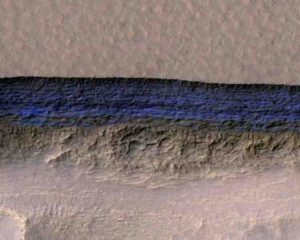
Home Blog Page 104

Fossil orphans reunited with their parents after half a billion years

Pseudooides
This is an image of Pseudooides. Credit: University of Bristol

Everyone wants to be with their family over the holidays, but spare a thought for a group of orphan fossils that have been separated from their parents since the dawn of animal evolution, over half a billion years ago.

For decades, paleontologists have puzzled over the microscopic fossils of Pseudooides, which are smaller than sand grains.

The resemblance of the fossils to animal embryos inspired their name, which means ‘false egg’.

The fossils preserve stages of embryonic development frozen in time by miraculous processes of fossilisation, which turned their squishy cells into stone.

Pseudooides fossils have a segmented middle like the embryos of segmented animals, such as insects, inspiring grand theories on how complex segmented animals may have evolved.

A team of paleontologists from the University of Bristol’s School of Earth Sciences and Peking University have now peered inside the Pseudooides embryos using X-rays and found features that link them to the adult stages of another fossil group.

It turns out that these adult stages were right under the scientists’ noses all along: they have been found long ago in the same rocks as Pseudooides.

Surprisingly, these long-lost family members are not complex segmented animals at all, but ancestors of modern jellyfish.

Dr Kelly Vargas from the University of Bristol said: “It seems that, in trying to classify these fossils, we’ve previously been barking up the wrong branch of the animals family tree.”

Professor Philip Donoghue, also from the University of Bristol, co-led the research with Professor Xiping Dong of Peking University.

Professor Donoghue added “We couldn’t have reunited these ancient family members without the amazing technology which allowed us to see inside the fossilized bodies of the embryos and adults.”

The team used the Swiss Light Source, a gigantic particle accelerator near Zurich, Switzerland, to supply the X-rays used to image the inside of the fossils.

This showed that the details of segmentation in the Pseudooides embryos to be nothing more than the folded edge of an opening, which developed into the rim of the cone-shaped skeleton that once housed the anemone-like stage in the life cycle of the ancient jellyfish.

Luis Porras, who helped make the discovery while still a student at the University of Bristol, said: “Pseudooides fossils may not tell us about how complex animals evolved, but they provide insights into the how embryology of animals itself has evolved.

“The embryos of living jellyfish usually develop into bizarre alien-like larvae which metamorphose into anemone-like adults before the final jellyfish (or ‘medusa’) phase.

“Pseudooides did things differently and more efficiently, developing directly from embryo to adult. Perhaps living jellyfish are a poor guide to ancestral animals.”

Professor Donoghue added: “It is amazing that these organisms were fossilised at all.

“Jellyfish are made up of little more than goo and yet they’ve been turned to stone before they had any chance to rot: a mechanism which some scientists refer to as the ‘Medusa effect’, named after the gorgon of Greek mythology who turned into stone anyone that laid eyes upon her.”

The Bristol team are still looking for fossil remains of the rest of Pseudooides life cycle, including the ‘medusa’ jellyfish stage itself. However, jellyfish fossils are few and far between, perhaps ironically because the ‘Medusa effect’ doesn’t seem to work on them.

In the interim, the embryos of Pseudooides have been reunited with their adult counterparts, just in time for Christmas.

Reference:
Baichuan Duan, Xi-Ping Dong, Luis Porras, Kelly Vargas, John A. Cunningham, Philip C. J. Donoghue. The early Cambrian fossil embryo Pseudooides is a direct-developing cnidarian, not an early ecdysozoan. Proceedings of the Royal Society B: Biological Sciences, 2017; 284 (1869): 20172188 DOI: 10.1098/rspb.2017.2188

Note: The above post is reprinted from materials provided by University of Bristol.

Oldest ice core ever drilled outside the polar regions

A joint research team from the United States and China ventured to the Guliya Ice Cap in Tibet in 2015
A joint research team from the United States and China ventured to the Guliya Ice Cap in Tibet in 2015. They drew a core from the ice that was more than 1,000 feet long, the bottom of which dates back to more than half a million years ago.
Credit: Photo by Giuliano Bertagna, courtesy of the Byrd Polar and Climate Research Center.

The oldest ice core ever drilled outside the polar regions may contain ice that formed during the Stone Age — more than 600,000 years ago, long before modern humans appeared.

Researchers from the United States and China are now studying the core — nearly as long as the Empire State Building is tall — to assemble one of the longest-ever records of Earth’s climate history.

What they’ve found so far provides dramatic evidence of a recent and rapid temperature rise at some of the highest, coldest mountain peaks in the world.

At the American Geophysical Union meeting on Thursday, Dec. 14, they report that there has been a persistent increase in both temperature and precipitation in Tibet’s Kunlun Mountains over the last few centuries. The change is most noticeable on the Guliya Ice Cap, where they drilled the latest ice core. In this region, the average temperature has risen 1.5 degrees Celsius (2.7 degrees Fahrenheit) in the last 50 years and the average precipitation has risen by 2.1 inches per year over the past 25 years.

Lonnie Thompson, Distinguished University Professor in the School of Earth Sciences at The Ohio State University and co-leader of the international research team, said that the new data lend support to computer models of projected climate changes.

“The ice cores actually demonstrate that warming is happening, and is already having detrimental effects on Earth’s freshwater ice stores,” Thompson said.

Earth’s largest supply of freshwater ice outside of the Arctic and Antarctica resides in Tibet — a place that was off limits to American glaciologists until 20 years ago, when Ohio State’s Byrd Polar and Climate Research Center (BPCRC) began a collaboration with China’s Institute of Tibetan Plateau Research. There, glaciologist Yao Tandong secured funding for a series of joint expeditions from the Chinese Academy of Sciences.

“The water issues created by melting ice on the Third Pole, along with that from the Arctic and Antarctica, have been recognized as important contributors to the rise in global sea level. Continued warming in these regions will result in even more ice melt with the likelihood of catastrophic environmental consequences,” Yao noted.

The name “Third Pole” refers to high mountain glaciers located on the Tibetan Plateau and in the Himalaya, in the Andes in South America, on Kilimanjaro in Africa, and in Papua, Indonesia — all of which have been studied by the Ohio State research team.

Of particular interest to the researchers is a projection from the Intergovernmental Panel on Climate Change that future temperatures on the planet will rise faster at high altitudes than they will at sea level. The warming at sea level is expected to reach 3 degrees Celsius by the year 2100, and possibly double that, or 6 degrees Celsius, at the highest mountain peaks in the low latitudes.

“The stable isotopic records that we’ve obtained from five ice cores drilled across the Third Pole document climate changes over the last 1,000 years, and contribute to a growing body of evidence that environmental conditions on the Third Pole, along with the rest of the world, have changed significantly in the last century,” Thompson said. “Generally, the higher the elevation, the greater the rate of warming that’s taking place.”

Around the world, hundreds of millions of people depend on high-altitude glaciers for their water supply. The Guliya Ice Cap is one of many Tibetan Plateau ice caches that provide fresh water to Central, South, and Southeast Asia.

“There are over 46,000 mountain glaciers in that part of the world, and they are the water source for major rivers,” Thompson said.

In September and October of 2015, the team ventured to Guliya and drilled through the ice cap until they hit bedrock. They recovered five ice cores, one of which is more than 1,000 feet long.

The cores are composed of compressed layers of snow and ice that settled on the western Kunlun Mountains year after year. In each layer, the ice captured chemicals from the air and precipitation during wet and dry seasons. Today, researchers analyze the chemistry of the different layers to measure historical changes in climate.

Based on dating of radioactive elements measured by scientists at the Swiss research center ETH Zurich, the ice at the base of the core may be at least 600,000 years old.

The oldest ice core drilled in the Northern Hemisphere was found in Greenland in 2004 by the North Greenland Ice Core Project and was dated to roughly 120,000 years, while the oldest continuous ice core record recovered on Earth to date is from Antarctica, and extends back 800,000.

Over the next few months, the American and Chinese research teams will analyze the chemistry of the core in detail. They will look for evidence of temperature changes caused by ocean circulation patterns in both the North Atlantic and tropical Pacific Oceans, which drive precipitation in Tibet as well as the Indian monsoons. For instance, one important driver of global temperatures, El Niño, leaves its chemical mark in the snow that falls on tropical glaciers.

Ultimately, researchers hope the work will reveal the linkages that exist between ice loss in tropical mountain glaciers and climate processes elsewhere on the planet. Thompson, Yao, and German ecologist Volker Mosbrugger are co-chairing a Third Pole Environment Program to focus on basic science and policy-relevant issues.

“The more we study the different components of the environment of the Third Pole, the better we understand climate change and its linkages among Earth’s three polar regions,” Yao said.

Note: The above post is reprinted from materials provided by Ohio State University. Original written by Pam Frost Gorder.

Dinosaur parasites trapped in 100-million-year-old amber tell blood-sucking story

Hard tick grasping a dinosaur feather preserved in 99 million-year-old Burmese amber.
Hard tick grasping a dinosaur feather preserved in 99 million-year-old Burmese amber. Modified from the open access article published in Nature Communications: ‘Ticks parasitised feathered dinosaurs as revealed by Cretaceous amber assemblages.’ Credit: Paper authors.

Fossilised ticks discovered trapped and preserved in amber show that these parasites sucked the blood of feathered dinosaurs almost 100 million years ago, according to a new article published in Nature Communications today.

Sealed inside a piece of 99 million-year-old Burmese amber researchers found a so-called hard tick grasping a feather. The discovery is remarkable because fossils of parasitic, blood-feeding creatures directly associated with remains of their host are exceedingly scarce, and the new specimen is the oldest known to date.

The scenario may echo the famous mosquito-in-amber premise of Jurassic Park, although the newly-discovered tick dates from the Cretaceous period (145-66 million years ago) and will not be yielding any dinosaur-building DNA: all attempts to extract DNA from amber specimens have proven unsuccessful due to the short life of this complex molecule.

“Ticks are infamous blood-sucking, parasitic organisms, having a tremendous impact on the health of humans, livestock, pets, and even wildlife, but until now clear evidence of their role in deep time has been lacking,” says Enrique Peñalver from the Spanish Geological Survey (IGME) and leading author of the work.

Cretaceous amber provides a window into the world of the feathered dinosaurs, some of which evolved into modern-day birds. The studied amber feather with the grasping tick is similar in structure to modern-day bird feathers, and it offers the first direct evidence of an early parasite-host relationship between ticks and feathered dinosaurs.

“The fossil record tells us that feathers like the one we have studied were already present on a wide range of theropod dinosaurs, a group which included ground-running forms without flying ability, as well as bird-like dinosaurs capable of powered flight,” explains Dr Ricardo Pérez-de la Fuente, a research fellow at Oxford University Museum of Natural History and one of the authors of the study.

“So although we can’t be sure what kind of dinosaur the tick was feeding on, the mid-Cretaceous age of the Burmese amber confirms that the feather certainly did not belong to a modern bird, as these appeared much later in theropod evolution according to current fossil and molecular evidence”.

The researchers found further, indirect evidence of ticks parasitising dinosaurs in Deinocroton draculi, or “Dracula’s terrible tick”, belonging to a newly-described extinct group of ticks. This new species was also found sealed inside Burmese amber, with one specimen remarkably engorged with blood, increasing its volume approximately eight times over non-engorged forms. Despite this, it has not been possible to directly determine its host animal.

“Assessing the composition of the blood meal inside the bloated tick is not feasible because, unfortunately, the tick did not become fully immersed in resin and so its contents were altered by mineral deposition,” explains Dr Xavier Delclòs, an author of the study from the University of Barcelona and IRBio.

But indirect evidence of the likely host for these novel ticks was found in the form of hair-like structures, or setae, from the larvae of skin beetles (dermestids), found attached to two Deinocroton ticks preserved together. Today, skin beetles feed in nests, consuming feathers, skin and hair from the nest’s occupants. And as no mammal hairs have yet been found in Cretaceous amber, the presence of skin beetle setae on the two Deinocroton draculi specimens suggests that the ticks’ host was a feathered dinosaur.

“The simultaneous entrapment of two external parasites – the ticks – is extraordinary, and can be best explained if they had a nest-inhabiting ecology as some modern ticks do, living in the host’s nest or in their own nest nearby,” says Dr David Grimaldi of the American Museum of Natural History and an author of the work.

Together, these findings provide direct and indirect evidence that ticks have been parasitising and sucking blood from dinosaurs within the evolutionary lineage leading to modern birds for almost 100 million years. While the birds were the only lineage of theropod dinosaurs to survive the mass extinction at the end of the Cretaceous 66 million years ago, the ticks did not just cling on for survival, they continued to thrive.

Reference:
Enrique Peñalver et al, parasitised feathered dinosaurs as revealed by Cretaceous amber assemblages, Nature Communications (2017). DOI: 10.1038/s41467-017-01550-z

Note: The above post is reprinted from materials provided by University of Oxford.

Small earthquakes at fracking sites may be early indicators of bigger tremors to come

Small earthquakes (yellow stars) can be induced during hydraulic fracturing when high-pressure fluid (blue arrows) is pumped into horizontal wells to crack rock layers containing natural gas.
Small earthquakes (yellow stars) can be induced during hydraulic fracturing when high-pressure fluid (blue arrows) is pumped into horizontal wells to crack rock layers containing natural gas. Earthquakes (green stars) can also be induced by disposal of wastewater from gas and oil operations into deep vertical wells. Over time, the disposal layer migrates away from the well (dashed green arrows), destabilizing preexisting faults. Credit: Clara Yoon

Stanford geoscientists have devised a way of detecting thousands of faint, previously missed earthquakes triggered by hydraulic fracturing, or “fracking.”

The technique can be used to monitor seismic activities at fracking operations to help reduce the likelihood of bigger, potentially damaging earthquakes from occurring, according to the new study.

“These small earthquakes may act like canaries in a coalmine,” said study co-author William Ellsworth, a professor (research) of geophysics at Stanford’s School of Earth, Energy & Environmental Sciences. “When they happen, they should be viewed as cautionary indicators of underground conditions that could lead to larger earthquakes.”

Fracking involves injecting high-pressure fluid underground to crack open rocks and release the natural gas trapped inside. As the rocks crack, they produce tiny earthquakes that were typically too small to be detected – until now.

“In our study, you can actually see individual earthquakes occurring next to the section of a well that’s being fracked,” said Stanford PhD student Clara Yoon, lead author of the study published in the Journal of Geophysical Research.

Arkansas earthquakes

In October 2010, residents near an Arkansas natural gas field were shaken by a magnitude 4 earthquake that was followed by two larger aftershocks in February 2011.

Scientists say these large earthquakes were caused by injections of wastewater from fracking sites into deep underground wells, and not by fracking operations closer to the surface.

“These were some of the first earthquakes related to shale-gas development to draw national attention,” Ellsworth said.

Earthquakes of magnitude 4 and higher have subsequently rattled Oklahoma, Texas and other gas- and oil-producing states.

Data mining

Using an advanced data-mining algorithm developed by Yoon and her colleagues, the Stanford team conducted a retrospective analysis of seismic activity in Arkansas prior to the magnitude 4 event. The algorithm uses earthquake-pattern recognition to generate detailed records of seismicity.

The analysis tracked seismic events generated at production wells that utilized fracking and at deeper wastewater-disposal wells nearby.

“We were interested in how the sequence that led to the magnitude 4 earthquake got started,” Yoon said. “We looked at the earliest period of seismic activity in 2010, from June 1 to September 1, when wastewater injection was just beginning.”

When Yoon ran the algorithm on this dataset, she discovered more than 14,000 small, previously unreported earthquakes. By comparing the timing and location of the tremors with fluid-injection data provided by the state of Arkansas, Yoon was able to demonstrate that most of the earthquakes were the direct result of fracking operations at 17 of the 53 production wells.

“That was a surprise,” said co-author Gregory Beroza, the Wayne Loel Professor of Geophysics at Stanford. “It had been thought, and we thought, that early earthquakes in this area were related to wastewater injection. But we found that the majority were caused by fracking.”

Persistent quakes

Many of the fracking-induced earthquakes were also bigger and more persistent that expected – unusual properties indicating potential trouble ahead.

Earthquakes generated by fracking are typically no larger than magnitude 0. That’s equivalent to the amount of energy released when a milk carton hits the floor after falling off a counter.

But several earthquakes observed in the study were magnitude 1, which is 31 times stronger than a magnitude 0 quake. A few were above magnitude 2, which is 1,000 times stronger than magnitude 0.

Most fracking-induced quakes occur near the well and dissipate quickly. But some of the Arkansas earthquakes were located far from the wellbore and continued weeks after fracking operations had ended.

“We were particularly surprised by the size and persistence of the seismicity,” Ellsworth said. “When earthquakes during fracking operations are larger than expected and persist for weeks, it indicates a high level of stress in that area. Faults under high stress are unstable and can slip, triggering larger earthquakes.”

The fact that fracking near wastewater wells induced thousands of earthquakes – too many, too big and lasting too long – was a red flag that stress conditions deeper down were also primed to create the instability that triggered larger earthquakes, he added.

“We want to encourage continuous seismic monitoring before fracking operations start, while they’re in progress and after they’ve finished,” Beroza said. “The algorithm Clara developed offers an efficient, cost-effective method for getting more information out of existing data, so that in the future informed decisions can be made that reduce the chance of larger earthquakes from happening.”

Reference:
Clara E. Yoon et al. Seismicity During the Initial Stages of the Guy-Greenbrier, Arkansas, Earthquake Sequence, Journal of Geophysical Research: Solid Earth (2017). DOI: 10.1002/2017JB014946

Note: The above post is reprinted from materials provided by Stanford University.

New research improves understanding of ancient landscapes

The Rio San Juan transports sediment from the High Andes
The Rio San Juan transports sediment from the High Andes (the most distant mountains in the photo) across the Precordillera mountain range (foreground). Credit: Tomas Capaldi

Geologists use zircon mineral grains to reconstruct what the Earth and its landscapes looked like in ancient times. These microscopic grains, commonly the width of a human hair, record detailed information on when and where they formed, making them a standard tool for studying how our planet has changed through the ages.

A new study led by The University of Texas at Austin Jackson School of Geosciences suggests that scientists may be able to better leverage zircon data to understand how landscapes have evolved over time by considering a suite of factors that can skew zircon geochronologic data and interpretation of the origin of sediments.

The study, published on Dec. 1 in Earth and Planetary Science Letters, focused on a method called detrital zircon U-Pb (uranium-lead) geochronology. Zircon is an ideal mineral to trace landscape evolution because it is found in most crustal rocks, is very durable (harder than diamond), and contains three isotopic clocks (chronometers) that geoscientist can utilize.

The researchers found that estimates of landscape erosion and sediment dispersal could be improved by taking several factors into account:

Bedrock materials erode at different rates. This means sediment in rivers will be disproportionately enriched in zircon grains derived from weaker, erodible bedrock sources.
Zircon fertility, a term that indicates how many zircons are in a bedrock source region. Materials that produce less zircons can be underrepresented in a study unless this issue is accounted for.
Some zircons come from material that has been recycled over time. That means the zircons could contain complex signatures from multiple erosion events from different rocks.

Tomas Capaldi, a Ph.D. student in the Jackson School’s Department of Geological Sciences, led the study by collecting zircon grain samples from modern river watersheds in the Andes Mountains where the sediment sources and drainage networks are well known, which is not the case in ancient settings. Capaldi’s goal was to test whether zircons in the river sand accurately reflected the erosion patterns of the modern Andes, and to understand the extent that the aforementioned factors—zircon fertility, bedrock erosion rate, and sediment recycling— can impact results.

“We’re exploring how we can use sediment from modern rivers to calibrate ourselves for the ancient sedimentary record,” Capaldi said. The research involved collecting samples of river sands and bedrock from drainage basins in the Andes of western Argentina, across a region about one-fifth the size of Texas. Ph.D. student Margo Odlum and Ryan McKenzie, an assistant Professor at University of Hong Kong and former Jackson School Postdoctoral Fellow, assisted with the work. The team collected 21 river sand samples and 23 bedrock samples in the Rio Mendoza and Rio San Juan basins, dating about 120 zircon grains per sample.

The study found that the greatest difference between known upstream bedrock sources and downstream river sands was recorded by zircons in small, localized drainage catchments. Results varied by location. For example, researchers found that smaller, high elevation Andean river catchments eroded weaker bedrock units more easily and these sediment sources disproportionately contributedmore sand to the river than anticipated. In contrast, the zircons were more accurate when sampling larger river systems, which receive sand from the entire region and record the overall erosion of the Andes.

The findings are important because thousands of studies a year depend on detrital zircon U-Pb geochronology, said Jackson School Professor

Brian Horton, Capaldi’s advisor and a co-author on the paper.

“They all make an assumption that these sediments, these zircon grains, are accurate reflections or one-to-one tracers of their source regions,” Horton said. “It turns out there are some serious complications.”

The good news is that this can be largely accounted for by researchers in the field and lab, said co-author and Jackson School Professor Danny Stockli.

“You might have to take some of these complications that Tomas points out, maybe even leverage them, to obtain a better understanding of long-term landscape evolution,” he said.

Capaldi said that the study clarifies how these factors influence patterns of erosion and sediment dispersal, and warrant further research.

“This is the first stepping stone,” he said. “We’re trying to determine what these zircons, as potential erosional tracers, are really showing.”

Stockli said that the work is vital because studies of river sands have exploded over the past decade by researchers trying to reconstruct ancient landscapes, and oil and gas companies trying to determine the link between sand and the generation of offshore energy reservoirs.”If you understand how river drainage areas evolved you learn something about how the surface of the planet was shaped in the past,” Stockli said. “At the same time, people use these drainage areas to make predictions of how much sediment is delivered to the ocean. These sands provide a memory of landscape erosion as well as a predictor of what might be offshore.”

Reference:
Tomas N. Capaldi et al. Sediment provenance in contractional orogens: The detrital zircon record from modern rivers in the Andean fold-thrust belt and foreland basin of western Argentina, Earth and Planetary Science Letters (2017). DOI: 10.1016/j.epsl.2017.09.001

Note: The above post is reprinted from materials provided by University of Texas at Austin.

Ancient weakening of Earth’s crust explains unusual intraplate earthquakes

Distribution of intraplate earthquakes in central and eastern North America
Distribution of intraplate earthquakes in central and eastern North America with respect to ancient faulting from the assembly of supercontinent Rodinia and the Grenville orogeny (red lines) and from the breakup of Rodinia and opening of the Iapetus Ocean (green lines). Credit: Thomas and Powell

New research reveals that mysterious pockets of earthquake activity in the middle of North America all have one thing in common: Earth’s crust in these zones underwent significant deformation hundreds of millions of years ago, creating weak areas that are more susceptible to earthquakes. These fracturing features could help explain why some regions in central and eastern North America are more seismically active than others.

Earthquakes typically happen along fault lines, like California’s San Andreas fault, where the edges of Earth’s tectonic plates scrape against each other, releasing enough energy to shake the ground. Some seismic activity occurs in the middle of tectonic plates, but these earthquakes are generally random, occur rarely and are poorly understood.

But a few spots within the North American tectonic plate – thousands of kilometers away from the plate’s boundaries – experience earthquake activity frequently.

Seismologists have found geological evidence of past earthquakes greater than magnitude 7 in some regions in the eastern U.S. and Canada. For example, from December 1811 to February 1812, three magnitude-7 earthquakes shook southeastern Missouri, knocking down trees, damaging homes and disrupting the Mississippi River current.

Seismologists don’t know why these pockets of earthquakes occur in the middle of tectonic plates, but a new study suggests they happen in places where Earth’s crust experienced ancient fracturing events on top of old, buried fault lines.

It is important to better understand these intraplate seismic zones since the earthquakes associated with them have the potential to deal significant damage, said Christine Powell, a seismologist at the University of Memphis Center for Earthquake Research and Information in Memphis, Tennessee and co-author of the new study accepted for publication in Tectonics, a journal of the American Geophysical Union.

While California’s infrastructure is built to withstand large tremors, construction in central and eastern North America typically does not account for strong earthquakes. If a magnitude 7 earthquake happened within the North American tectonic plate today, communities would sustain serious injuries and face multi-billion-dollar damages to property, Powell said.

“We have to understand as much as we possibly can about why the earthquakes are here,” she said. “All of that information can then be used to help public safety and building construction.”

Waking up ancient faults

Seismologists know that many intraplate seismic zones overlap with ancient fault lines. But only parts of old fault lines in central and eastern North America show frequent earthquake activity. Unlike California, where earthquakes occur along the entire San Andreas Fault line, central and eastern North America experience seismic hiccups on only specific segments of old faults. The rest of the inner-North American faults are seismically inactive.

In the new study, Powell and her co-author Bill Thomas, an emeritus professor of geology at the University of Kentucky and now at the Geological Survey of Alabama in Tuscaloosa, reviewed the most active seismic spots in eastern and central North America to determine what geologic features may be involved with intraplate earthquakes.

Thomas and Powell examined three places in particular: the Charlevoix Seismic Zone (CSZ) in southeastern Canada, the Eastern Tennessee Seismic Zone (ETSZ), and the New Madrid Seismic Zone (NMSZ) along the Mississippi River valley between southeastern Missouri and western Tennessee. They surveyed the known geological characteristics of the three regions and soon realized each zone had experienced significant fracturing compared to other areas along the old faults.

The researchers reason that fracturing events from hundreds of millions of years ago have lowered the ability of Earth’s crust to withstand high levels of stress in these regions. This means that a weaker crust has a higher chance of breaking under the pressure of various geological forces, resulting in more seismic activity.

For example, roughly 357 million years ago, a large meteor hit the Charlevoix Seismic Zone, shattering rocks within the crust, likely creating the perfect conditions along the ancient fault to host future seismic activity, according to the researchers.

“You can look up and down the rest of those long faults and you don’t see the earthquake activity in other places. It’s just where that big meteorite smacked it,” Powell said.

An old fault line running through the Eastern Tennessee Seismic Zone is bent instead of straight, which created additional fracturing in the area as the North American Plate moved over time. The New Madrid Seismic Zone encompasses a segment of ancient fault lines where the two sides of the North American continent began to pull apart, but stopped short of making a significant break. The plates instead crunched back together, leaving the crust significantly faulted and fractured.

In each case, crustal deformation has weakened the crust along ancient fault lines, according to the researchers’ findings.

Past research has examined intraplate seismic zones individually, but no study has yet made an overall comprehensive attempt to explain all of them, Thomas said.

“This is the first [study] that actually answers the question: why do [intraplate earthquake zones] happen where they do,” Powell said.

The researchers point out that there are other spots within eastern and central North America that may have concentrated crustal deformation but lack significant seismic activity. Therefore, they suspect that crustal deformation is necessary for creating intraplate seismic zones, but intraplate earthquakes occur only in places with the right present-day crustal forces.

“If the various forces acting on the crust are oriented in the right direction, those faults down there will be reactivated,” Powell said.

This story is republished courtesy of AGU Blogs (http://blogs.agu.org), a community of Earth and space science blogs, hosted by the American Geophysical Union. Read the original story here.

Note: The above post is reprinted from materials provided by American Geophysical Union.

How much can 252-million-year-old ecosystems tell us about modern Earth? A lot

This map of Pangea shows the distribution of life during the late Permian period
This map of Pangea shows the distribution of life during the late Permian period. Many species exclusively thrived near the equator, including early amphibian tetrapods and early crocodiles and dinosaurs, while animals like dicynodonts (early mammal-relatives) were in greater abundance farther north and south. Credit: Brandon Peecook, The Field Museum, using illustrations from Wikimedia Commons

A whopping 252 million years ago, Earth was crawling with bizarre animals, including dinosaur cousins resembling Komodo dragons and bulky early mammal-relatives, a million years before dinosaurs even existed. New research shows us that the Permian equator was both a literal and figurative hotspot: it was, for the most part, a scorching hot desert, on top of having a concentration of unique animals. Here, you could find some of the first tetrapods to emerge from the water and live on land, living right next to newly evolved, dinosaur and crocodile-like reptiles. Many of these species were wiped out after an extinction which changed life on the planet forever.

In a paper published in Earth-Science Reviews, paleontologists studied fossil sites all over the world from the late Permian to get an idea of what lived where. They found an unusual assortment of species near the equator, and one that is comparable to the modern tropics — except that the array of large, carnivorous reptiles would look very out of place anywhere on Earth today.

“The tropics act as a diversity center — stuff that has gone extinct elsewhere is still alive there, and there’s new stuff evolving,” explains Postdoctoral Researcher Brandon Peecook, co-author of the paper. While it makes sense that the warm, wet rainforests we see now have incredible diversity, it seems counterintuitive that these fiery, hot deserts were home to an exceptional range of species, especially because diversity at the equator fluctuates so much historically.

These findings about the late Permian beg the question, “Why are we seeing so much biodiversity at the equator?” This is something scientists have yet to answer, but it shows us that biodiversity at the tropics isn’t intuitive, and isn’t consistent. What scientists know for sure is that regardless of desert or rainforest, climate change negatively impacts living things.

This unequaled comparison of Permian climate and species distribution to modern events shows us that while many changes are natural and we see them throughout our planet’s history, drastic changes like this can be triggered by something much larger — volcanic activity likely caused this in the Permian, and human activity is the suspected culprit today. After the Permian extinction, “it was almost as though the slate had been wiped clean, and all the ecosystems had to rebuild,” says Peecook. This event altered life permanently and while new animals evolved and thrived, the process of recovery took millions of years, and the animals that were lost never returned.

“If we want to know how Earth’s systems work, what’s expected and what’s normal, we need to look to the past,” and the fossil record is the best measure of ecosystem stability. As we already begin to face extinctions and carbon levels similar to those before the Permian extinction, examining these patterns over time gives us the evidence we need to measure and minimize our impact on climate, preventing further permanent damage to our planet’s ecosystems and animals.

Reference:
Massimo Bernardi, Fabio Massimo Petti, Evelyn Kustatscher, Matthias Franz, Christoph Hartkopf-Fröder, Conrad C. Labandeira, Torsten Wappler, Johanna H.A. van Konijnenburg-van Cittert, Brandon R. Peecook, Kenneth D. Angielczyk. Late Permian (Lopingian) terrestrial ecosystems: A global comparison with new data from the low-latitude Bletterbach Biota. Earth-Science Reviews, 2017; 175: 18 DOI: 10.1016/j.earscirev.2017.10.002

Note: The above post is reprinted from materials provided by Field Museum.

Nuclear technology unlocks 50-million-year-old time capsules

Sample of amber
Sample of amber. Credit: Monash University

A scientific analysis of fossilised tree resin has caused a rethink of Australia’s prehistoric ecosystem, and could pave the way to recovering more preserved palaeobiological artefacts from the time of dinosaurs or prehistoric mammals.

In a project that could be straight out of Jurassic Park, Monash University researchers and collaborators from the Deakin Institute of Frontier Materials (IFM) used nuclear magnetic resonance to investigate the make-up of 52 to 40-million-year-old amber samples recovered from sites in Anglesea, Victoria, and Strahan, Tasmania.

Study lead author, Andrew Coward, an Honours student from the Monash School of Earth, Atmosphere and Environment, said the amber captured a period in time during the Eocene Epoch (56 to 33.9 million years ago).

“This is an unparalleled method of preservation, and provides insights into past organisms, ecosystems and environments,” said Mr Coward.

Amber, also called resinite or fossilised resin, is organic material created through the fossilisation of the resins of seed plants.

“Our collaboration aimed to identify the original plant sources of amber at Anglesea and Strahan and to establish the way they degraded during their tens of millions of years underground,” said co-researcher Associate Professor Jeffrey Stilwell, also from the Monash School of Earth, Atmosphere and Environment.

Project collaborator Dr Luke O”Dell from IFM said this degradation could potentially have a major impact on the preserved palaeobiological information contained within the samples, and the sort of information we can recover about Earth’s ancient past.

By measuring how each sample absorbed and re-emitted electromagnetic radiation, Dr O”Dell, was able to probe the physical and chemical properties of the amber and identify distinct botanical sources.

Monash University researchers conducted their own chemical analysis using reflective and infrared spectroscopy.

“Nuclear magnetic resonance turned out to be extremely useful as it provided us with a unique fingerprint of the chemical structure of each piece of amber,” Associate Professor Stilwell said.

“This study, sponsored by the Australian Research Council Discovery Projects scheme (led by Stilwell), could represent the first unambiguous discovery of indigenous Class II amber in Australia,” he said.

“Amber can be separated into different classes based on which plants it came from, and the discovery of Class II amber from the Anglesea site could mean certain prehistoric plants capable of producing cadinene-based amber were native to Australia during the Eocene Epoch, which is something that has never been proven due to their absence from the fossil record.

“Another possibility is that there may even be an entirely new, previously unidentified botanical source capable of exuding cadinene resins.”

Associate Professor Stilwell said other outcomes of the study had important implications for the field of amber prospecting, by demonstrating how even visually altered amber could still be used to recover valid palaeobotanical and palaeobiological data.

Of particular note was the amount of amber that showed no significant chemical changes despite being extensively visibly altered during millions of years beneath the earth, suggesting such samples could still have preserved intact palaeobiological and palaeoenvironmental information.

Understanding which factors and reactions influence amber as it degrades and how this impacts stored biochemical information could make it much easier for the future collection of amber with intact palaeobiological data.

Dr O”Dell said the discovery was even more significant due to Australia’s sparse amber record.

“While there have been recent reports of amber stretching back 100 million years to the mid-Cretaceous period, the largest known deposits of Australian amber come from the Latrobe Valley coal measures in Victoria and are roughly 3 million to 23 million years old,” he said.

All amber samples that remained after IFM’s analysis are now being housed with Museums Victoria.

The project’s full findings, “Taphonomy and chemotaxonomy of Eocene amber from southeastern Australia,” have been accepted for publication in the Organic Geochemistry journal.

Note: The above post is reprinted from materials provided by Monash University.

What geologists got wrong about the world’s biggest failed rift

Dramatic cliffs on the shores of Lake Superior.
Geologists have disproved a theory about what stopped the formation of the Midcontinent Rift, which is responsible for creating the dramatic cliffs on the shores of Lake Superior. Credit: Northwestern University

Geologists have corrected a mix-up that made an ancient geological structure in the central U.S. seem hundreds of miles shorter than it really is. The biggest failed rift known to geologists is even bigger than originally thought, according to research that will be presented at the American Geophysical Union fall meeting Dec. 11 in New Orleans.

The Midcontinent Rift, which started but failed to split North America in two pieces 1.1 billion years ago, is the biggest failed rift ever discovered. It was formed when 350,000 cubic miles of volcanic rock poured out of the rift and formed the beautiful cliffs around Lake Superior. South of Lake Superior, the volcanic rocks are covered by younger rocks, so it wasn’t clear how far the rift extended.

For decades, geologists believed the rift stopped in southern Michigan, but a joint study by geologists at the University of Illinois at Chicago (UIC), Northwestern University, the University of Oklahoma and the University of Göttingen, Germany, reveals the rift extends much farther – as far south as Oklahoma.

Successful geologic rifts cut through the Earth’s surface, splitting continents in two and forming new ocean basins, but something prevented the Midcontinent Rift from completing this process. Until now, geologists believed the Grenville Front halted the Midcontinent Rift’s growth.

“Geologists got confused by the Grenville Front, which appears in southeast Canada,” said Carol Stein, lead author of the study and professor of Earth and environmental sciences at UIC. “It marks where another continent collided with North America after the Midcontinent Rift formed.”

“Somehow the idea developed that the Grenville Front extended south into the U.S., cutting off the Midcontinent Rift in Southern Michigan,” explained coauthor Seth Stein, professor of Earth and planetary sciences in Northwestern’s Weinberg College of Arts and Sciences. “That didn’t make sense because there wasn’t any good reason for the rift to stop there.

To sort this out, the researchers used gravity data to “see” underground.

“The Midcontinent Rift shows up nicely,” explained coauthor Reece Elling, a graduate student in Earth and planetary sciences at Northwestern. “The rift’s volcanic rocks are very dense, so they pull downward strongly. In contrast, the Grenville Front doesn’t have these dense rocks, and so it doesn’t cause the gravity high we see.”

The gravity high shows that the underground rift has an east arm that extends south from Lake Superior through Michigan, Ohio, Kentucky, Tennessee and Alabama. The gravity high also maps a western arm that extends as far south as Oklahoma.

“This make sense in terms of how continents grow,” said coauthor Jonas Kley of the University of Göttingen, Germany.

The new analysis “makes the Midcontinent Rift great again,” explains coauthor Randy Keller, professor emeritus of geology and geophysics at the University of Oklahoma. “It’s a major structure and should be recognized accordingly.”

The results of the study will be published in GSA Today.

Note: The above post is reprinted from materials provided by Northwestern University.

New species of extinct marsupial lion discovered in Australia

Reconstruction of Wakaleo schouteni
Reconstruction of Wakaleo schouteni challenging the thylacinid Nimbacinus dicksoni over a kangaroo carcass in the late Oligocene forest at Riversleigh.
Credit: Illustration by Peter Schouten in the Journal of Systematic Palaeontology

A team of Australian scientists has discovered a new species of marsupial lion which has been extinct for at least 19 million years. The findings, published in the Journal of Systematic Palaeontology, are based on fossilised remains of the animal’s skull, teeth, and humerus (upper arm bone) found by University of New South Wales (UNSW) scientists in the Riversleigh World Heritage Area of remote north-western Queensland.

Named in honour of palaeoartist Peter Schouten, Wakaleo schouteni was a predator that stalked Australia’s abundant rainforests some 18 to 26 million years ago in the late Oligocene to early Miocene era. This meat-eating marsupial is estimated to have been about the size of a dog and weighed around 23 kilograms.

The new species is about a fifth of the weight of the largest and last surviving marsupial lion, Thylacoleo carnifex, that weighed in at around 130 kilograms and which has been extinct for 30,000 years. Members of this family, the Thylacoleonidae, had highly distinct large, blade-like, flesh-cutting premolars that they used to tear up prey.

The discovery comes just a year after the fossilised remains of a kitten-sized marsupial lion were found in the same famous fossil site in Queensland. The UNSW scientists named that miniature predator Microleo attenboroughi after broadcasting legend Sir David Attenborough.

With this new find, the researchers believe that two different species of marsupial lion were present in the late Oligocene at least 25 million years ago. The other, originally named Priscileo pitikantensis, but renamed Wakaleo pitikantensis, was slightly smaller and was identified from teeth and limb bones discovered near Lake Pitikanta in South Australia in 1961.

This latest discovery reveals that the new species (W. schouteni) exhibits many skull and dental features of the genus Wakaleo but it also shared a number of similarities with P. pitikantensis — particularly the presence of three upper premolars and four molars, previously the diagnostic feature of Priscileo. Further similarities of the teeth and humerus which are shared with W. schouteni indicate that P. pitikantensis is a species of Wakaleo.

According to the authors, these dental similarities distinguish W. schouteni and W. pitikantensis from later species of this genus, all of which show premolar and molar reduction, and suggest that they are the most primitive members of the genus.

Lead author Dr Anna Gillespie, a palaeontologist from the University of New South Wales (UNSW) in Sydney, Australia says that the latest finding raises new questions about the evolutionary relationships of marsupial lions: “The identification of these new species have brought to light a level of marsupial lion diversity that was quite unexpected and suggest even deeper origins for the family.”

Reference:
Anna K. Gillespie, Michael Archer, Suzanne J. Hand. A new Oligo–Miocene marsupial lion from Australia and revision of the family Thylacoleonidae. Journal of Systematic Palaeontology, 2017; 1 DOI: 10.1080/14772019.2017.1391885

Note: The above post is reprinted from materials provided by Taylor & Francis Group.

It’s all in the ears: Inner ears of extinct sea monsters mirror those of today’s animals

Transparent skulls of an extinct plesiosaur (top) and a living crocodile (bottom).
Caption Transparent skulls of an extinct plesiosaur (top) and a living crocodile (bottom). The inner ear is the pink structure towards the back of the head.
Credit: James Neenan

A new study led by Oxford University Museum of Natural History has revealed that an extinct group of marine reptiles called sauropterygians evolved similar inner ear proportions to those of some modern day aquatic reptiles and mammals. The research is published in Current Biology today.

Sauropterygians were swimming reptiles from the ‘Age of Dinosaurs’ that included some semi-aquatic forms, nearshore swimmers and fully-aquatic ‘underwater-flyers’. Their most well-known members are the plesiosaurs, ferocious sea monsters with four flippers, which hunted anything from small fish and squid to large marine reptiles.

The inner ear is a structure shared by all vertebrates, containing an important sense organ that helps maintain balance and orientation. Aquatic animals move more naturally in a three-dimensional environment, so have different sensory inputs compared to animals which live on land. The inner ear is therefore very useful for detecting differences in locomotion in extinct animals, especially by comparing with living organisms.

Researchers were surprised when sauropterygians with very different lifestyles had evolved inner ears that were very similar to those of some modern animals.

“Sauropterygians are completely extinct and have no living descendants,” said Dr James Neenan, lead author of the study. “So I was amazed to see that nearshore species with limbs that resemble those of terrestrial animals had ears similar to crocodylians, and that the fully-aquatic, flippered plesiosaurs had ears similar to sea turtles.”

The similarities don’t end there. Some groups of plesiosaurs, the ‘pliosauromorphs’, evolved enormous heads and very short necks, a body shape that is shared by modern whales. Whales have the unusual feature of highly miniaturized inner ears (blue whales have a similar-sized inner ear to humans), possibly the result of having such a short neck. Neenan and colleagues have now shown that ‘pliosauromorph’ plesiosaurs also have a reduced inner ear size, supporting this idea.

These interesting results are the product of convergent evolution, the process in which completely unrelated organisms evolve similar solutions to the same evolutionary hurdles.

“Nearshore sauropterygians swam in a similar way and had comparable lifestyles to modern-day crocodiles, so had similar inputs on the inner ear organ,” said Dr Neenan. “Plesiosaurs also ‘flew’ under water with similar flippers to those of sea turtles. So it’s not surprising that the organ of balance and orientation evolved to be a similar shape between these unrelated groups.”

Reference:
James M. Neenan, Tobias Reich, Serjoscha W. Evers, Patrick S. Druckenmiller, Dennis F.A.E. Voeten, Jonah N. Choiniere, Paul M. Barrett, Stephanie E. Pierce, Roger B.J. Benson. Evolution of the Sauropterygian Labyrinth with Increasingly Pelagic Lifestyles. Current Biology, 2017; DOI: 10.1016/j.cub.2017.10.069

Note: The above post is reprinted from materials provided by University of Oxford.

Revising the story of the dispersal of modern humans across Eurasia

Map of sites and postulated migratory pathways associated with modern humans dispersing across Asia during the Late Pleistocene.
Credit: Bae et al. 2017. On the origin of modern humans: Asian perspectives. Science. Image by: Katerina Douka and Michelle O’Reilly

Most people are now familiar with the traditional “Out of Africa” model: modern humans evolved in Africa and then dispersed across Asia and reached Australia in a single wave about 60,000 years ago. However, technological advances in DNA analysis and other fossil identification techniques, as well as an emphasis on multidisciplinary research, are revising this story. Recent discoveries show that humans left Africa multiple times prior to 60,000 years ago, and that they interbred with other hominins in many locations across Eurasia.

A review of recent research on dispersals by early modern humans from Africa to Asia by researchers from the Max Planck Institute for the Science of Human History and the University of Hawai’i at Manoa confirms that the traditional view of a single dispersal of anatomically modern humans out of Africa around 60,000 years ago can no longer be seen as the full story. The analysis, published in the journal Science, reviews the plethora of new discoveries being reported from Asia over the past decade, which were made possible by technological advances and interdisciplinary collaborations, and shows that Homo sapiens reached distant parts of the Asian continent, as well as Near Oceania, much earlier than previously thought. Additionally, evidence that modern humans interbred with other hominins already present in Asia, such as Neanderthals and Denisovans, complicates the evolutionary history of our species.

New model: Multiple dispersals of modern humans out of Africa, beginning as early as 120,000 years ago

The authors brought together findings from multiple recent studies to refine the picture of human dispersals out of Africa and into Asia. While scientists once thought that humans first left Africa in a single wave of migration about 60,000 years ago, recent studies have identified modern human fossils in far reaches of Asia that are potentially much older. For example, H. sapiens remains have been found at multiple sites in southern and central China that have been dated to between 70,000 and 120,000 years ago. Additional finds indicate that modern humans reached Southeast Asia and Australia prior to 60,000 years ago.

However, other recent studies do confirm that all present-day non-African populations branched off from a single ancestral population in Africa approximately 60,000 years ago. This could indicate that there were multiple, smaller dispersals of humans out of Africa beginning as early as 120,000 years ago, followed by a major dispersal 60,000 years ago. While the recent dispersal contributed the bulk of the genetic make-up of present-day non-Africans, the earlier dispersals are still evident.

“The initial dispersals out of Africa prior to 60,000 years ago were likely by small groups of foragers, and at least some of these early dispersals left low-level genetic traces in modern human populations. A later, major ‘Out of Africa’ event most likely occurred around 60,000 years ago or thereafter,” explains Michael Petraglia of the Max Planck Institute for the Science of Human History.

Multiple interbreeding events

Recent genetic research has resolved the question of whether or not modern humans interbred with other ancient hominins — they definitely did. Modern humans interbred not only with Neanderthals, but also with our recently-discovered relatives the Denisovans, as well as a currently unidentified population of pre-modern hominins. One estimate is that all present-day non-Africans have 1-4% Neanderthal heritage, while another group has estimated that modern Melanesians have an average of 5% Denisovan heritage. In all, it is now clear that modern humans, Neanderthals, Denisovans and perhaps other hominin groups likely overlapped in time and space in Asia, and they certainly had many instances of interaction.

The increasing evidence of interactions suggests that the spread of material culture is also more complicated than previously thought. “Indeed, what we are seeing in the behavioral record is that the spread of so-called modern human behaviors did not occur in a simple time-transgressive process from west to east. Rather, ecological variation needs to be considered in concert with behavioral variation between the different hominin populations present in Asia during the Late Pleistocene,” explains Christopher Bae of the University of Hawai’i at Manoa.

In light of these new discoveries, our understanding of human movements across the Old World has become much more complex, and there are still many questions left open. The authors argue for the development of more complicated models of human dispersals and for conducting new research in the many areas of Asia where none has been done to date. Additionally, it will be important to review materials collected prior to the development of modern analytic methods, to see what more can now be learned from them. “Fortunately,” states Katerina Douka, also of the Max Planck Institute for the Science of Human History, “there have been an increasing number of multidisciplinary research programs launched in Asia over the past few decades. The information that is being reported is helping to fill in the gaps in the evolutionary records.”

“It is an exciting time to be involved with interdisciplinary research projects across Asia,” adds Bae.

Reference:
Christopher J. Bae, Katerina Douka, Michael D. Petraglia. On the origin of modern humans: Asian perspectives. Science, 2017; 358 (6368): eaai9067 DOI: 10.1126/science.aai9067

Note: The above post is reprinted from materials provided by Max Planck Institute for the Science of Human History.

How the oldest compound eyes were constructed

Trilobite
Trilobite. Credit: G. Baranov

Researchers from Cologne, Tallinn, and Edinburgh have found out that the compound eyes of today’s arthropods are still constructed in much the same way as they were in their ancestors 500 million years ago. The research team looked at fossil trilobites. However, these arthropods lacked the lenses of contemporary compound eyes. The zoologist Dr Brigitte Schoenemann and her colleagues have now published the results of their research in the Proceedings of the National Academy of Sciences.

Dr Brigitte Schoenemann (University of Cologne) and her colleagues Helje Pärnaste (Tallinn, Estonia), and Euan Clarkson (Edinburgh, Scotland) have succeeded in unraveling the structure and functioning of the oldest known compound eye. The researchers used an exceptionally well-preserved fossil trilobite (Schmidtiellus reetae), which is over half a billion years old, showing the cellular structure of a compound eye. It not only shows how this eye was constructed, but also its functioning, its performance, and how it differs from contemporary compound eyes. The results show that modern compound eyes work in ways strikingly similar to those of half a billion years ago. They are very conservative in their structure — and quite successfully so. “The principle of the modern compound eye most likely goes back to before the times of our first fossil records. Half a billion years ago, it was in the early stage of its development, and with our work we have succeeded in uncovering the first visible steps of this extremely successful visual principle,” says Schoenemann.

The eye belongs to a trilobite found in Estonia, an extinct arthropod that lived in the oceans of the Palaeozoic. The findings from this geological layer have brought to light the very first fossils of complex animals. The right eye of the trilobite is slightly abraded, allowing for a view into its interior. It is a typical compound eye consisting of approximately 100 subunits placed relatively far apart compared to modern forms. The authors were able to show that each of these subunits (ommatidia) consists of about eight sensory cells — just like modern compound eyes — grouped around a central rhabdom, a light-guiding receptive structure. The latter contains the visual pigments and conveys the brightness of the surrounding environment to the animal’s central nervous system.

“However, in contrast to the modern compound eyes of bees, dragonflies, and many crabs, this very old compound eye does not have a lens,” Schoenemann explains. “This is likely due to the fact that these rather soft-shelled arthropods lacked the necessary layer in their shell responsible for lens formation.” The physical features of the central rhabdom ensures that each element of the compound eye has a limited field of vision and that the animal’s overall visual impression already has the mosaic-like character of a modern compound eye. The precision of such an eye can be determined by the number of its elements — just like the number of pixels determines the precision of a computer graphic. “With approximately 100 ‘pixels,’ the performance of this eye dating back more than half a billion years is certainly not outstanding. But it was sufficient to provide the trilobite with information on movement in its field of vision, for example approaching predators. It could roughly discern the distribution of light in its surroundings or avoid obstacles in its path,” says Schoenemann.

The biologist and her team were also able to show that only a few million years after Schmidtiellus, new and improved compound eyes with higher resolution developed in another trilobite from the Baltic region: Holmia kjerulfi. The performance of this species’ eyes even approximated that of modern dragonflies. A physical analysis of the compound eyes of both trilobites showed that the organism inhabited bright waters, most likely coastal shelf regions of a Palaeozoic ocean.

Reference:
Brigitte Schoenemann, Helje Pärnaste, Euan N. K. Clarkson. Structure and function of a compound eye, more than half a billion years old. Proceedings of the National Academy of Sciences, 2017; 201716824 DOI: 10.1073/pnas.1716824114

Note: The above post is reprinted from materials provided by University of Cologne.

Synchrotron sheds light on the amphibious lifestyle of a new raptorial dinosaur

Halszkaraptor escuilliei
Reconstruction of Halszkaraptor escuilliei. This small dinosaur was a close relative of Velociraptor, but in both body shape and inferred lifestyle it much closely recalls some waterbirds like modern swans.
Credit: Lukas Panzarin; and Andrea Cau for scientific supervision

An exceptionally well-preserved dinosaur skeleton from Mongolia unites an unexpected combination of features that defines a new group of semi-aquatic predators related to Velociraptor. Detailed 3D synchrotron analysis allowed an international team of researchers to present the bizarre 75 million-year-old predator, named Halszkaraptor escuilliei, in Nature. The study not only describes a new genus and species of bird-like dinosaur that lived during the Campanian stage of the Cretaceous in Mongolia but also sheds light on an unexpected amphibious lifestyle for raptorial dinosaurs.

Theropods encompass all carnivorous dinosaurs, including the largest land-living predators in the history of life on Earth, such as Tyrannosaurus, and iconic agile hunters like Velociraptor. During 160 million years of the Mesozoic Era, theropods became the dominant predators on all continents, yet never conquered aquatic environments. Although some theropods reportedly incorporated fish in their diet, proposed indications for aquatic locomotion associated with exclusively aquatic lifestyles remain controversial.

A swan-necked and flipper-forelimbed new dinosaur species that combines an unexpected mix of features now demonstrates that some bird-like dinosaurs did adopt a semi-aquatic lifestyle. The fossil, nicknamed “Halszka” for Halszkaraptor escuilliei, was found at Ukhaa Tolgod. This locality in southern Mongolia has been known by palaeontologists for decades and is often targeted by poachers. “Illicit fossil trade presents a great challenge to modern palaeontology and accounts for a dramatic loss of Mongolian scientific heritage,” says Pascal Godefroit of the Royal Belgian Institute of Natural Sciences in Brussels. “Illegally exported from Mongolia, Halszka resided in private collections around the world before it was acquired in 2015 and offered to palaeontologists for study and to prepare its return to Mongolia.”

Although several important groups of predatory dinosaurs have been discovered in Mongolia, Halszka does not belong to any of them, having a number of strange features that are mostly absent among dinosaurs, but are shared by reptilian and avian groups with aquatic or semiaquatic ecologies. “The first time I examined the specimen, I even questioned whether it was a genuine fossil” says Andrea Cau of the Geological Museum Capellini in Bologna. Although Halszka is unique in many ways, certain parts of the skeleton, including the sickle-shaped “killer claws” on its feet, are shared with well-known dinosaurs such as Velociraptor. “This unexpected mix of traits makes it difficult to place Halszka within traditional classifications,” Cau remarks.

In order to ascertain the integrity of the fossil, the specimen was visualised and reconstructed in three dimensions using synchrotron multi-resolution X-ray microtomography. “This technique is currently the most powerful and sensitive method to image internal details without damaging invaluable fossils. The ESRF has become the worldwide leader for high quality X-ray imaging of such precious specimens,” notes Paul Tafforeau of the ESRF. “We had to mobilise an ESRF team of palaeontologists to study the complete anatomy of Halzka. So far, it’s the specimen for which the greatest number of experiments were made on a single fossil,” adds Tafforeau.

“Our first goal was to demonstrate that this bizarre and unexpected fossil is indeed a genuine animal: multi-resolution scanning confirmed that the skeleton is not a composite assembled from parts of different dinosaurs,” explains Dennis Voeten of the ESRF. “We implemented new methods for the acquisition and optimisation of tomographic scan data, which not only confirmed the integrity of the specimen, but also revealed additional palaeontological information,” Vincent Fernandez of the ESRF clarifies.

The synchrotron was even able to reveal, in astonishing detail, those parts of the skeleton that have remained deep within the rock ever since the dinosaur got buried. “Our analysis demonstrated that numerous teeth, which are not visible externally, are still preserved inside the mouth,” says Vincent Beyrand of the ESRF. “We also identified a neurovascular mesh inside its snout that resembles those of modern crocodiles to a remarkable degree. These aspects suggest that Halszka was an aquatic predator.”

The ESRF data revealed that the fossil represents a new genus and species of amphibious dinosaur that walked on two legs on land, with postural adaptations similar to short-tailed birds (like ducks), but used its flipper-like forelimbs to manoeuvre in water (like penguins and other aquatic birds), relying on its long neck for foraging and ambush hunting.

This new species was named Halszkaraptor escuilliei. Its generic name honours the late palaeontologist Halszka Osmólska. “This important genus is named in recognition of Halszka’s contribution to the study of Mongolian dinosaurs from the Gobi,” comments Rinchen Barsbold of the Mongolian Academy of Sciences. “The specific name refers to François Escuillié and thereby acknowledges his role in the first recognition and in the return of this specimen to Mongolia,” adds Khishigjav Tsogtbaatar of the Institute of Paleontology and Geology in Ulaanbaatar.

Halszkaraptor is not the only strange dinosaur recovered from the Gobi. Several previously described enigmatic Mongolian theropods were closely related to the new species, the study found. United in a new group, named Halszkaraptorinae, “is an unexpected subfamily of dromaeosaurs — the group colloquially known as raptors. This bizarre subfamily appears to have evolved a lifestyle different from all other predatory dinosaurs,” says Philip Currie of the University of Alberta.

“When we look beyond fossil dinosaurs, we find most of Halszkaraptor’s unusual features among aquatic reptiles and swimming birds,” concludes lead author Andrea Cau. “The peculiar morphology of Halszkaraptor fits best with that of an amphibious predator that was adapted to a combined terrestrial and aquatic ecology: a peculiar lifestyle that was previously unreported in these dinosaurs. Thanks to synchrotron tomography, we now demonstrate that raptorial dinosaurs not only ran and flew, but also swam!”

Reference:
Andrea Cau, Vincent Beyrand, Dennis F. A. E. Voeten, Vincent Fernandez, Paul Tafforeau, Koen Stein, Rinchen Barsbold, Khishigjav Tsogtbaatar, Philip J. Currie, Pascal Godefroit. Synchrotron scanning reveals amphibious ecomorphology in a new clade of bird-like dinosaurs. Nature, 2017; DOI: 10.1038/nature24679

Note: The above post is reprinted from materials provided by European Synchrotron Radiation Facility.

Recently discovered fossil shows transition of a reptile from life on land to life in the sea

Vadasaurus herzogi fossil.
This is a Vadasaurus herzogi fossil. Credit: Mick Ellison Used with permission from the American Museum of Natural History

Using modern research tools on a 155-million-year-old reptile fossil, scientists at Johns Hopkins and the American Museum of Natural History report they have filled in some important clues to the evolution of animals that once roamed land and transitioned to life in the water.

A report on the new discoveries about the reptile, Vadasaurus herzogi, appears online in the Nov. 8 issue of Royal Society Open Science, and suggests that some of the foot-long animal’s features, including its elongated, whip-like tail, and triangular-shaped head, are well suited to aquatic life, while its relatively large limbs link it to land-loving species.

Vadasaurus, which is the Latin term for “wading lizard,” was discovered in limestone quarries near Solnhofen, Germany, part of a once-shallow sea long explored for its rich trove of fossil finds.

The well-preserved fossil is housed in the American Museum of Natural History in New York, where the job of unlocking its evolutionary secrets fell to museum research associate Gabriel Bever, Ph.D., who is also assistant professor of functional anatomy and evolution at the Johns Hopkins University School of Medicine, and Mark Norell, Ph.D., the museum’s paleontology division chair.

“Anatomic and behavioral characteristics of modern groups of living things accumulated over long spans of time,” says Bever. “Fossils can teach us a lot about that evolutionary history, including the order in which those features evolved and their adaptive role in a changing environment.”

“Anytime we can get a fossil like this that is so well preserved, and so significant in understanding a major environmental transition, it is very important,” says Norell. “It’s so important,” he adds, “that we can consider Vadasaurus to be the Archaeopteryx of rynchocephalians.”

According to Bever, their work adds to the list of sea creatures whose ancestors were land-dwelling vertebrates. They include modern-day whales, seals, and sea snakes, and ancient (and now-extinct) species of ichthyosaurs, mosasaur, and plesiosaurs.

Bever says their study offers evidence that Vadasaurus, likely an adult when it died, can be linked by its anatomy to a small group of marine species called pleurosaurs, which have long been thought to have terrestrial roots. Pleurosaurs lived during the Jurassic period, 185 to 150 million years ago. The eel-like creatures had reduced limbs that were probably used for steering rather than propulsion in the water. Until now, fossils of only three ancient species of pleurosaurs have been discovered.

Using two types of statistical algorithms and reconstructions of evolutionary “trees,” Bever and Norell say that Vadasaurus and the pleurosaurs are part of a larger lineage of reptiles called Rhynchocephalia. Like the sea-loving pleurosaurs, Vadasaurus’ skull was a triangular shape, an adaptation found among many streamlined, water-dwelling animals, such as most fish, eels and whales. An elongated snout, common among sea animals, featured teeth farther away from the body for ensnaring fish.

By examining the shape and structure of the Vadasaurus’ skull, Bever and Norell also concluded that Vadasaurus’ bite was likely a quick, side-to-side motion, compared with the slower, stronger bite typical of many land-dwelling animals.

Some 155 million years ago, Vadasaurus’ tail had begun to lengthen like most modern sea animals, says Bever, but not to the size of the 5-foot pleurosaur. Vadasaurus, they found, had 24 pre-sacral vertebrae, which span from the head to the beginning of the tail, whereas pleurosaurus had more than 50 such back bones.

Despite its aquatic features, Vadasaurus retained some features more often found among land vertebrates. For example, Vadasaurus still had the large limbs, relative to the size of its body, expected of a land-dwelling reptile. Bever speculates that Vadasaurus did not use its limbs for propulsion in the water, but to steer. He says Vadasaurus may have swum like a modern sea snake, moving its spinal column with an undulating kind of motion.

“Our data indicate that Vadasaurus is an early cousin of the pleurosaur,” says Bever. “And these two reptiles are closely related to modern tuatara.” The modern tuatara is a lizard-like, land-dwelling reptile that lives on New Zealand’s coastal islands and is the single remaining species of rhynchocephalian still left on Earth.

Bever notes that a complete evolutionary history of Vadasaurus will require more data and fossil finds.

“We don’t know exactly how much time Vadasaurus was spending on land versus in the water. It may be that the animal developed its aquatic adaptations for some other reason, and that these changes just happened to be advantageous for life in the water,” says Bever.

Reference:
Gabriel S. Bever, Mark A. Norell. A new rhynchocephalian (Reptilia: Lepidosauria) from the Late Jurassic of Solnhofen (Germany) and the origin of the marine Pleurosauridae. Royal Society Open Science, 2017; 4 (11): 170570 DOI: 10.1098/rsos.170570

Note: The above post is reprinted from materials provided by Johns Hopkins Medicine.

Litte Foot takes a bow: The world’s most complete Australopithecus skeleton ever found

"Australopithecus skeleton" Little Foot Skull from the Sterkfontein Caves.
Professor Ron Clarke busy excavating the Little Foot Skull from the Sterkfontein Caves.
Credit: Wits University

South Africa’s status as a major cradle in the African nursery of humankind has been reinforced with today’s unveiling of “Little Foot,” the country’s oldest, virtually complete fossil human ancestor.

Little Foot is the only known virtually complete Australopithecus fossil discovered to date. It is by far the most complete skeleton of a human ancestor older than 1.5 million years ever found. It is also the oldest fossil hominid in southern Africa, dating back 3.67 million years. The unveiling will be the first time that the completely cleaned and reconstructed skeleton can be viewed by the national and international media.

Discovered by Professor Ron Clarke from the Evolutionary Studies Institute at the University of the Witwatersrand in Johannesburg, South Africa, the fossil was given the nickname of “Little Foot” by Prof. Phillip Tobias, based on Clarke’s initial discovery of four small footbones. Its discovery is expected to add a wealth of knowledge about the appearance, full skeletal anatomy, limb lengths and locomotor abilities of one of the species of our early ancestral relatives.

“This is one of the most remarkable fossil discoveries made in the history of human origins research and it is a privilege to unveil a finding of this importance today,” says Clarke.

After lying undiscovered for more than 3.6 million years deep within the Sterkfontein caves about 40km north-west of Johannesburg, Clarke found several foot bones and lower leg bone fragments in 1994 and 1997 among other fossils that had been removed from rock blasted from the cave years earlier by lime miners. Clarke sent his assistants Stephen Motsumi and Nkwane Molefe into the deep underground cave to search for any possible broken bone surface that might fit with the bones he had discovered in boxes. Within two days of searching, they found such a contact, in July 1997.

Clarke realised soon after the discovery that they were on to something highly significant and started the specialised process of excavating the skeleton in the cave up through 2012, when the last visible elements were removed to the surface in blocks of breccia. “My assistants and I have worked on painstakingly cleaning the bones from breccia blocks and reconstructing the full skeleton until the present day,” says Clarke.

In the 20 years since the discovery, they have been hard at work to excavate and prepare the fossil. Now Clarke and a team of international experts are conducting a full set of scientific studies on it. The results of these studies are expected to be published in a series of scientific papers in high impact, peer reviewed international journals in the near future.

This is the first time that a virtually complete skeleton of a pre-human ancestor from a South African cave has been excavated in the place where it was fossilised.

“Many of the bones of the skeleton are fragile, yet they were all deeply embedded in a concrete-like rock called breccia,” Clarke explains.

“The process required extremely careful excavation in the dark environment of the cave. Once the upward-facing surfaces of the skeleton’s bones were exposed, the breccia in which their undersides were still embedded had to be carefully undercut and removed in blocks for further cleaning in the lab at Sterkfontein,” says Clarke.

The 20-year long period of excavation, cleaning, reconstruction, casting, and analysis of the skeleton has required a steady source of funding, which was provide by the Palaeontological Scientific Trust (PAST) — a Johannesburg-based NGO that promotes research, education and outreach in the sciences related to our origins. Among its many initiatives aimed at uplifting the origin sciences across Africa, PAST has been a major funder of research at Sterkfontein for over two decades.

Professor Adam Habib, Vice-Chancellor and Principal of the University of the Witwatersrand says: “This is a landmark achievement for the global scientific community and South Africa’s heritage. It is through important discoveries like Little Foot that we obtain a glimpse into our past which helps us to better understand our common humanity.”

PAST’s chief scientist Professor Robert Blumenschine labels the discovery a source of pride for all Africans. “Not only is Africa the storehouse of the ancient fossil heritage for people the world over, it was also the wellspring of everything that makes us human, including our technological prowess, our artistic ability, and our supreme intellect,” he says.

The scientific value of the find and much more will be unveiled in a series of papers that Prof Clarke and a team of international experts have been preparing, with many expected in the next year.

Note: The above post is reprinted from materials provided by University of the Witwatersrand.

Unearthing the underground effects of earthquakes and volcanoes

The time variation of seismic velocity relative to the averaged pre-earthquake value are displayed.
The time variation of seismic velocity relative to the averaged pre-earthquake value are displayed. Each panel shows the central date within the 30-day window: (a) 8 March, (b) 1 May, (c) 1 June, and (d) 1 October 2016. Warm colors indicate regions where seismic velocity was decreased. During the 2016 earthquake, seismic velocity around the seismogenic Hinagu-Futagawa fault system and Mount Aso decreased greatly. Cold colors indicate regions where seismic velocity was increased. Seismic velocity at Mount Aso recovered rapidly and was faster than the pre-earthquake velocity after the eruption. The date described above shows the central date within the 30-day window. Yellow or white dots are Hi-net stations.
Credit: Science Advances

Most of what we know about earthquakes and volcanoes is based on what we can observe at the Earth’s surface. However, most of the action — especially early activity that could help with disaster prediction and preparedness — occurs deep underground.

Developing a clearer picture of changes in subsurface conditions, together with continuous monitoring, could provide life-saving information in advance of future disasters. In earthquake-prone Japan, especially, there is ongoing need for effective means of foreseeing seismic activity.

Japan’s National Research Institute for Earth Science and Disaster Prevention (NIED) has developed the Hi-net network of hundreds of high-sensitivity seismographs evenly distributed across the country. High-resolution seismic data from Hi-net shed light on the workings far below the country’s surface. A key source of information from Hi-net is the velocity of seismic waves as they travel between stations. Faults, fractures, and fluids in the subsurface, among other factors, can influence seismic velocity. Thus, changes in seismic velocity can signal changes occurring underground but not yet apparent at the surface.

Until recently, little variation in seismic velocity had been detected in central Kyushu, Japan’s southernmost major island. However, in April 2016, the MW 7.0 Kumamoto earthquake struck the region, shortly after a MW 6.2 foreshock. These destructive earthquakes were followed by eruptions of Japan’s largest active volcano, Mount Aso, in April, May, and October of the same year.

A trio of researchers at Kyushu University and its International Institute for Carbon-Neutral Energy Research (I2CNER) investigated Hi-net seismic velocity data, collected continuously from December 2015 to November 2016, to better understand the subsurface conditions associated with these disasters. They reported their findings in Science Advances.

“We applied seismic interferometry to the ambient noise recorded at 36 Hi-net seismic stations,” Tatsunori Ikeda explains. “We found that during the earthquake, velocity slowed significantly, which may have been related to damage and pressure changes around the deep rupture fault. This was followed by gradual ‘healing’ of the fault over the following months, although different areas recovered to different extents.”

The earthquakes also may have mobilized fluids around Aso’s magma body. Velocity below the caldera decreased when the earthquake struck, but recovered relatively rapidly after the eruptions; this may have released pressure.

“Although past studies have used similar approaches for velocity estimation, the higher spatial resolution we achieved over a broad area allowed us to identify the spatial distribution of the damage zone or stress state,” corresponding author Takeshi Tsuji says. “Denser deployment allows local anomalies to be more accurately resolved. Velocity changes thus identified could be useful in the estimation of future earthquakes and volcanic activity.”

Reference:
Hiro Nimiya, Tatsunori Ikeda, Takeshi Tsuji. Spatial and temporal seismic velocity changes on Kyushu Island during the 2016 Kumamoto earthquake. Science Advances, 2017; 3 (11): e1700813 DOI: 10.1126/sciadv.1700813

Note: The above post is reprinted from materials provided by Kyushu University, I2CNER.

Discovery about rare nitrogen molecules offers clues to makeup of life-supporting planets

Earth from space
Scientists have discovered a planetary-scale tug-of-war between life, deep Earth and the upper atmosphere that is expressed in atmospheric nitrogen. Credit: ISS Expedition 7 Crew, EOL, NASA

A team of scientists using a state-of-the-art UCLA instrument reports the discovery of a planetary-scale “tug-of-war” of life, deep Earth and the upper atmosphere that is expressed in atmospheric nitrogen.

Earth’s atmosphere differs from the atmospheres of most other rocky planets and moons in our solar system in that it is rich in nitrogen gas, or N2; Earth’s atmosphere is 78 percent nitrogen gas. Titan, the largest of Saturn’s more than 60 moons, is the other body in our solar system with a nitrogen-rich atmosphere that resembles ours.

Compared with other key elements of life — such as oxygen, hydrogen and carbon — molecular nitrogen is very stable. Two nitrogen atoms combine to form N2 molecules that stay in the atmosphere for millions of years.

The majority of nitrogen has an atomic mass of 14. Less than one percent of nitrogen has an extra neutron. While this heavy isotope, nitrogen-15, is rare, N2 molecules that contain two nitrogen-15s — which chemists call 15N15N — are the rarest of all N2 molecules.

The team of scientists measured the amount of 15N15N in air and discovered that this rare form of nitrogen gas is far more abundant than scientists had expected. Earth’s atmosphere contains about two percent more 15N15N than can be accounted for by geochemical processes occurring near Earth’s surface.

“This excess was not known before because nobody could measure it,” said senior author Edward Young, a UCLA professor of geochemistry and cosmochemistry. “Our one-of-a-kind Panorama mass spectrometer allows us to see this for the first time. We conducted experiments showing that the only way for this excess of 15N15N to occur is by rare reactions in the upper atmosphere. Two percent is a huge excess.”

Young said the enrichment of 15N15N in Earth’s atmosphere is a signature that’s unique to our planet. “But it also gives us a clue about what signatures of other planets might look like, especially if they are capable of supporting life as we know it.”

The research is published in the journal Science Advances.

“We didn’t believe the measurements at first, and spent about a year just convincing ourselves that they were accurate,” said lead author Laurence Yeung, an assistant professor of Earth, environmental and planetary sciences at Rice University.

The study began four years ago when Yeung, then a UCLA postdoctoral scholar in Young’s laboratory, learned about the first-of-its-kind mass spectrometer that was being installed in Young’s laboratory.

“At that time, no one had a way to reliably quantify 15N15N,” said Yeung, who joined Rice’s faculty in 2015. “It has an atomic mass of 30, the same as nitric oxide. The signal from nitric oxide usually overwhelms the signal from 15N15N in mass spectrometers.”

The difference in mass between nitric oxide and 15N15N is about two one-thousandths the mass of a neutron. When Yeung learned that the new machine in Young’s laboratory could discern this slight difference, he applied for grant funding from the National Science Foundation to learn exactly how much 15N15N is in Earth’s atmosphere.

Co-authors Joshua Haslun and Nathaniel Ostrom at Michigan State University conducted experiments on N2-consuming and N2-producing bacteria that allowed the team to determine their 15N15N signatures.

These experiments suggested that one should see a bit more 15N15N in air than random pairings of nitrogen-14 and nitrogen-15 would produce — an enrichment of about 1 part per 1,000, Yeung said.

“There was a bit of enrichment in the biological experiments, but not nearly enough to account for what we’d found in the atmosphere,” Yeung said. “In fact, it meant that the process causing the atmospheric 15N15N enrichment has to fight against this biological signature. They are locked in a tug-of-war.”

The team found that zapping mixtures of air with electricity, which simulates the chemistry of the upper atmosphere, could produce enriched levels of 15N15N like they measured in air samples.

The researchers tested air samples from ground level and from altitudes of about 20 miles, as well as dissolved air from shallow ocean water samples.

“We think the 15N15N enrichment fundamentally comes from chemistry in the upper atmosphere, at altitudes close to the orbit of the International Space Station,” Yeung said. “The tug-of-war comes from life pulling in the other direction, and we can see chemical evidence of that. We can see the tug-of-war everywhere.”

Reference:
Laurence Y. Yeung, Shuning Li, Issaku E. Kohl, Joshua A. Haslun, Nathaniel E. Ostrom, Huanting Hu, Tobias P. Fischer, Edwin A. Schauble, Edward D. Young. Extreme enrichment in atmospheric 15 N 15 N. Science Advances, 2017; 3 (11): eaao6741 DOI: 10.1126/sciadv.aao6741

Note: The above post is reprinted from materials provided by University of California – Los Angeles.

Meteorite analysis shows reduced salt is key in Earth’s new recipe

This is a reflected light image of a metal-sulphide clast in the enstatite chondrite ALH 77295
This is a reflected light image of a metal-sulphide clast in the enstatite chondrite ALH 77295. The central portion of the clast is a mineral called djerfisherite, an important host for chlorine in these meteorites. Credit: Dr Patricia Clay, The University of Manchester

Scientists have found the halogen levels in the meteorites that formed the Earth billions of years ago are much lower than previously thought.

The research was carried out by international team of researchers, led by the Universities of Manchester and Oxford, and has recently been published in Nature.

Halogens such as Chlorine, Bromine and Iodine, form naturally occurring salts which are essential for most life forms — but too much can prohibit life. When previously comparing halogen levels in meteorites that formed the planet, the Earth should have unhealthy levels of salt.

Many theories have been put forward to explain the mystery of why, instead, Earth salt concentrations are ‘just right’. The answer turns out to be quite simple — previous estimates meteorites were just too high.

Using a new analytical technique, the team looked at different kinds of chondrite meteorites, a type of primitive meteorite approximately 4.6 billion years old.

Dr Patricia Clay, lead author of the study from the University of Manchester’s School of Earth and Environmental Sciences (SEES), said: ‘These kinds of meteorites are remnants of the solar nebula, a molecular cloud made up of interstellar dust and hydrogen gas that predates our Solar System. Studying them provides important clues for our understanding of the origin and age of the Solar System.’

How the Earth acquired its volatile elements has long interested scientists. To answer the question the team re-examined one of the largest collection of meteorites assembled for this type of study.

They found that previous estimates of halogen levels in meteorites were too high, but the technique used by the team helped them avoid contaminated sources.

Dr Clay explains: “No single model of Earth formation using the old meteorite measurements could easily account for the halogens we see today. Some of these models needed catastrophic planetary wide removal of halogens without affecting related elements — which just didn’t make sense.”

Professor Ray Burgess, co-author and also from The University of Manchester, added: “The new simplified model we have developed is a big step forward in understanding how key ingredients essential for life were brought to our planet, including water that probably helped distribute the halogens between the planetary interior and surface.”

The results were a huge surprise, and time after time each meteorite measured was found to have halogen levels far lower than previously thought, and remarkably consistent between different types of meteorites.

Professor Chris Ballentine, co-author from the University of Oxford and who designed the study, added: “Another big surprise of the study was just how uniform the halogen content of very different meteorites actually is — this is an incredibly important picture into the processes that formed the meteorites themselves — but also means that whatever meteorites formed the earth the halogen ingredients for Earth’s recipe remains the same.”

Reference:
Patricia L. Clay, Ray Burgess, Henner Busemann, Lorraine Ruzié-Hamilton, Bastian Joachim, James M. D. Day, Christopher J. Ballentine. Halogens in chondritic meteorites and terrestrial accretion. Nature, 2017; 551 (7682): 614 DOI: 10.1038/nature24625

Note: The above post is reprinted from materials provided by University of Manchester.

Using Sensors Beneath Our Feet to Tell Us About Earthquakes, Water, and Other Geophysical Phenomenon

erkeley Lab team that used fiber optic cables for detecting earthquakes and other subsurface activity.
Shan Dou (from left), Jonathan Ajo-Franklin, and Nate Lindsey were on a Berkeley Lab team that used fiber optic cables for detecting earthquakes and other subsurface activity. Credit: Berkeley Lab

Scientists at the Department of Energy’s Lawrence Berkeley National Laboratory (Berkeley Lab) have shown for the first time that dark fiber – the vast network of unused fiber-optic cables installed throughout the country and the world – can be used as sensors for detecting earthquakes, the presence of groundwater, changes in permafrost conditions, and a variety of other subsurface activity.

In a pair of recently published papers, a team led by Berkeley Lab researcher Jonathan Ajo-Franklin announced they had successfully combined a technology called “distributed acoustic sensing,” which measures seismic waves using fiber-optic cables, with novel processing techniques to allow reliable seismic monitoring, achieving results comparable to what conventional seismometers can measure.

“This has huge potential because you can just imagine long stretches of fibers being turned into a massive seismic network,” said Shan Dou, a Berkeley Lab postdoctoral fellow. “The idea is that by using fiber that can be buried underground for a long time, we can transform traffic noise or other ambient vibrations into usable seismic signals that can help us to monitor near-surface changes such as permafrost thaw and groundwater-level fluctuations.”

Dou is the lead author of “Distributed Acoustic Sensing for Seismic Monitoring of the Near Surface: A Traffic-Noise Interferometry Case Study,” which was published in September in Nature’s Scientific Reports and verified the technique for monitoring the Earth’s near surface. More recently, Ajo-Franklin’s group published a follow-up study led by UC Berkeley graduate student Nate Lindsey, “Fiber-Optic Network Observations of Earthquake Wavefields,” in Geophysical Research Letters (GRL), which demonstrates the viability of using fiber-optic cables for earthquake detection.

What is dark fiber?

Dark fiber refers to unused fiber-optic cable, of which there is a glut thanks to a huge rush to install the cable in the early 1990s by telecommunications companies. Just as the cables were buried underground, the technology for transmitting data improved significantly so that fewer cables were needed. There are now dense corridors of dark fiber crisscrossing the entire country.

Distributed acoustic sensing (DAS) is a novel technology that measures seismic wavefields by shooting short laser pulses across the length of the fiber. “The basic idea is, the laser light gets scattered by tiny impurities in the fiber,” said Ajo-Franklin. “When fiber is deformed, we will see distortions in the backscattered light, and from these distortions, we can measure how the fiber itself is being squeezed or pulled.”

Using a test array they installed in Richmond, California – with fiber-optic cable placed in a shallow L-shaped trench, one leg of about 100 meters parallel to the road and another perpendicular – the researchers verified that they could use seismic waves generated by urban traffic, such as cars and trains, to image and monitor the mechanical properties of shallow soil layers.

The measurements give information on how “squishy” the soil is at any given point, making it possible to infer a great deal of information about the soil properties, such as its water content or texture. “Imagine a slinky – it can compress or wiggle,” Ajo-Franklin said. “Those correspond to different ways you can squeeze the soil, and how much energy it takes to reduce its volume or shear it.”

He added: “The neat thing about it is that you’re making measurements across each little unit of fiber. All the reflections come back to you. By knowing all of them and knowing how long it takes for a laser light to travel back and forth on the fiber you can back out what’s happening at each location. So it’s a truly distributed measurement.”

Having proven the concept under controlled conditions, the team said they expect the technique to work on a variety of existing telecommunications networks, and they are currently conducting follow-up experiments across California to demonstrate this. Ongoing research in Alaska is also exploring the same technique for monitoring the stability of Arctic permafrost.

Added Dou: “We can monitor the near surface really well by using nothing but traffic noise. It could be fluctuations in groundwater levels, or changes that could provide early warnings for a variety of geohazards such as permafrost thaw, sinkhole formation, and landslides.”

Using fiber for quake detection

Building on five years of Berkeley Lab-led research exploring the use of DAS for subsurface monitoring using non-earthquake seismic sources, Ajo-Franklin’s group has now pushed the envelope and has shown that DAS is a powerful tool for earthquake monitoring as well.

In the GRL study led by Lindsey in collaboration with Stanford graduate student Eileen Martin, the research team took measurements using the DAS technique on fiber-optic arrays in three locations – two in California and one in Alaska. In all cases, DAS proved to be comparably sensitive to earthquakes as conventional seismometers, despite its higher noise levels. Using the DAS arrays, they assembled a catalog of local, regional, and distant earthquakes and showed that processing techniques could take advantage of DAS’ many channels to help understand where earthquakes originate from.

Ajo-Franklin said that dark fiber has the advantage of being nearly ubiquitous, whereas traditional seismometers, because they are expensive, are sparsely installed, and subsea installations are particularly scarce. Additionally, fiber allows for dense spatial sampling, meaning data points are only meters apart, whereas seismometers typically are separated by many kilometers.

Lindsey added: “Fiber has a lot of implications for earthquake detection, location, and early warning. Fiber goes out in the ocean, and it’s all over the land, so this technology increases the likelihood that a sensor is near the rupture when an earthquake happens, which translates into finding small events, improved earthquake locations, and extra time for early warning.”

The GRL paper notes other potential applications of using the dark fiber, including urban seismic hazard analysis, global seismic imaging, offshore submarine volcano detection, nuclear explosion monitoring, and microearthquake characterization.

Reference:

  1. Nathaniel J. Lindsey et al, Fiber-optic network observations of earthquake wavefields, Geophysical Research Letters (2017). DOI: 10.1002/2017GL075722
  2. Shan Dou et al. Distributed Acoustic Sensing for Seismic Monitoring of The Near Surface: A Traffic-Noise Interferometry Case Study, Scientific Reports (2017). DOI: 10.1038/s41598-017-11986-4

Note: The above post is reprinted from materials provided by Lawrence Berkeley National Laboratory.

Related Articles