Geologists have corrected a mix-up that made an ancient geological structure in the central U.S. seem hundreds of miles shorter than it really is. The biggest failed rift known to geologists is even bigger than originally thought, according to research that will be presented at the American Geophysical Union fall meeting Dec. 11 in New Orleans.
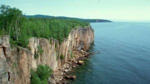
The Midcontinent Rift, which started but failed to split North America in two pieces 1.1 billion years ago, is the biggest failed rift ever discovered. It was formed when 350,000 cubic miles of volcanic rock poured out of the rift and formed the beautiful cliffs around Lake Superior. South of Lake Superior, the volcanic rocks are covered by younger rocks, so it wasn’t clear how far the rift extended.
For decades, geologists believed the rift stopped in southern Michigan, but a joint study by geologists at the University of Illinois at Chicago (UIC), Northwestern University, the University of Oklahoma and the University of Göttingen, Germany, reveals the rift extends much farther – as far south as Oklahoma.
Successful geologic rifts cut through the Earth’s surface, splitting continents in two and forming new ocean basins, but something prevented the Midcontinent Rift from completing this process. Until now, geologists believed the Grenville Front halted the Midcontinent Rift’s growth.
“Geologists got confused by the Grenville Front, which appears in southeast Canada,” said Carol Stein, lead author of the study and professor of Earth and environmental sciences at UIC. “It marks where another continent collided with North America after the Midcontinent Rift formed.”
“Somehow the idea developed that the Grenville Front extended south into the U.S., cutting off the Midcontinent Rift in Southern Michigan,” explained coauthor Seth Stein, professor of Earth and planetary sciences in Northwestern’s Weinberg College of Arts and Sciences. “That didn’t make sense because there wasn’t any good reason for the rift to stop there.
To sort this out, the researchers used gravity data to “see” underground.
“The Midcontinent Rift shows up nicely,” explained coauthor Reece Elling, a graduate student in Earth and planetary sciences at Northwestern. “The rift’s volcanic rocks are very dense, so they pull downward strongly. In contrast, the Grenville Front doesn’t have these dense rocks, and so it doesn’t cause the gravity high we see.”
The gravity high shows that the underground rift has an east arm that extends south from Lake Superior through Michigan, Ohio, Kentucky, Tennessee and Alabama. The gravity high also maps a western arm that extends as far south as Oklahoma.
“This make sense in terms of how continents grow,” said coauthor Jonas Kley of the University of Göttingen, Germany.
The new analysis “makes the Midcontinent Rift great again,” explains coauthor Randy Keller, professor emeritus of geology and geophysics at the University of Oklahoma. “It’s a major structure and should be recognized accordingly.”
The results of the study will be published in GSA Today.
Note: The above post is reprinted from materials provided by Northwestern University.


