The Yukon River is a major watercourse of northwestern North America. The source of the river is located in British Columbia, Canada. The next portion lies in, and gives its name to Yukon. The lower half of the river lies in the U.S. state of Alaska. The river is 3,190 kilometres (1,980 mi) long and empties into the Bering Sea at the Yukon-Kuskokwim Delta. The average flow is 6,430 m³/s (227,000 ft³/s). The total drainage area is 832,700 km² (321,500 mi²), of which 323,800 km² (126,300 mi²) is in Canada. By comparison, the total area is more than 25% larger than Texas or Alberta.
The longest river in Alaska and Yukon, it was one of the principal means of transportation during the 1896–1903 Klondike Gold Rush. A portion of the river in Yukon—”The Thirty Mile” section, from Lake Laberge to the Teslin River—is a national heritage river and a unit of Klondike Gold Rush International Historical Park. Paddle-wheel riverboats continued to ply the river until the 1950s, when the Klondike Highway was completed. After the purchase of Alaska by the United States in 1867, the Alaska Commercial Company acquired the assets of the Russian-American Company and constructed several posts at various locations on the Yukon River.
The Russians named the Yukon River, believing that “yuk-khana” was a Deg Xinag phrase meaning big river. However, “yuk-khana” is not a Deg Xinag phrase meaning big river. Probably, the Deg Hit’an borrowed the name from an upriver language and borrowed the “big river” meaning from the Central Yup’ik name. Most likely, Yukon was derived from an obsolete Gwich’in word, which included the concept of long water or wide water, but did not mean “big” river or “great” river. The Lewes River is the former name of the upper course of the Yukon, from Marsh Lake to the confluence of the Pelly River at Fort Selkirk.
The Yukon River has had a history of pollution from gold mining, military installations, dumps, wastewater, and other sources. However, the Environmental Protection Agency does not list the Yukon River among its impaired watersheds, and water quality data from the U.S. Geological Survey shows relatively good levels of turbidity, metals, and dissolved oxygen.
The Yukon River Inter-Tribal Watershed Council, a cooperative effort of 70 First Nations and tribes in Alaska and Canada, has the goal of making the river and its tributaries safe to drink from again by supplementing and scrutinizing Government data.
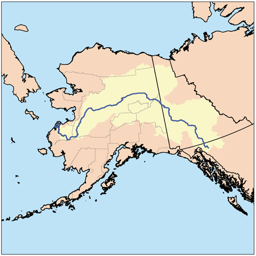
Course
The generally accepted source of the Yukon River is the Llewellyn Glacier at the southern end of Atlin Lake in British Columbia. Others suggest that the source is Lake Lindeman at the northern end of the Chilkoot Trail. Either way, Atlin Lake flows into Tagish Lake (via the Atlin River), as eventually does Lake Lindeman after flowing into Bennett Lake. Tagish Lake then flows into Marsh Lake (via the Tagish River). The Yukon River proper starts at the northern end of Marsh Lake, just south of Whitehorse. Some argue that the source of the Yukon River should really be Teslin Lake and the Teslin River, which has a larger flow when it reaches the Yukon at Hootalinqua. The upper end of the Yukon River was originally known as the Lewes River until it was established that it actually was the Yukon. North of Whitehorse, the Yukon River widens into Lake Laberge, made famous by Robert W. Service’s “The Cremation of Sam McGee”. Other large lakes that are part of the Yukon River system include Kusawa Lake (into the Takhini River) and Kluane Lake (into the Kluane and then White River).
The river passes through the communities of Whitehorse, Carmacks, (just before the Five Finger Rapids) and Dawson City in Yukon, and crossing Alaska into Eagle, Circle, Fort Yukon, Stevens Village, Rampart, Tanana, Ruby, Galena, Nulato, Grayling, Holy Cross, Russian Mission, Marshall, Pilot Station, St. Marys (which is accessible from the Yukon at Pitkas Point), and Mountain Village. After Mountain Village, the main Yukon channel frays into many channels, sprawling across the delta. There are a number of communities after the “head of passes,” as the channel division is called locally: Nunum Iqua, Alakanuk, Emmonak, and Kotlik. Of those delta communities, Emmonak is the largest with roughly 760 people in the 2000 census. Emmonak’s gravel airstrip is the regional hub for flights.
Geography and ecology
Some of the upper slopes of this watershed (e.g. Nulato Hills) are forested by Black Spruce. This locale near the Seward Peninsula represents the near westernmost limit of the Black Spruce, Picea mariana, one of the most widespread conifers in northern North America.
Note : The above story is based on materials provided by Wikipedia


