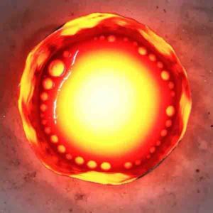
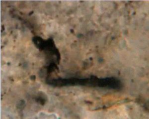
Home Blog Page 105

Trickle-down is the solution (to the planetary core formation problem)

New research from The University of Texas at Austin adds evidence to a theory that claims the metallic cores
New research from The University of Texas at Austin adds evidence to a theory that claims the metallic cores of rocky planets like Earth were formed when molten metal trapped between grains of silicate rock percolated to the center of the planet during its early formation. Credit: UT Austin

Scientists have long pondered how rocky bodies in the solar system — including our own Earth — got their metal cores. According to research conducted by The University of Texas at Austin, evidence points to the downwards percolation of molten metal toward the center of the planet through tiny channels between grains of rock.

The finding calls into question the interpretation of prior experiments and simulations that sought to understand how metals behave under intense heat and pressure when planets are forming. Past results suggested that large portions of molten metals stayed trapped in isolated pores between the grains. In contrast, the new research suggests that once those isolated pores grow large enough to connect, the molten metal starts to flow, and most of it is able to percolate along grain boundaries. This process would let metal trickle down through the mantle, accumulate in the center, and form a metal core, like the iron core at the heart of our home planet.

“What we’re saying is that once the melt network becomes connected, it stays connected until almost all of the metal is in the core,” said co-author Marc Hesse, an associate professor in the UT Jackson School of Geosciences Department of Geological Sciences, and a member of UT’s Institute for Computational Engineering and Sciences.

The research was published on Dec. 4 in the Proceedings of the National Academy of Sciences. The work was the doctoral thesis of Soheil Ghanbarzadeh, who earned his Ph.D. while a student in the UT Department of Petroleum and Geosystems Engineering (now the Hildebrand Department of Petroleum and Geosystems Engineering). He currently works as a reservoir engineer with BP America. Soheil was jointly advised by Hesse and Maša Prodanovic, an associate professor in the Hildebrand Department and a co-author.

Planets and planetesimals (small planets and large asteroids) are formed primarily from silicate rocks and metal. Part of the planet formation process involves the initial mass of material separating into a metallic core and a silicate shell made up of the mantle and the crust. For the percolation theory of core formation to work, the vast majority of metal in the planetary body must make its way to the center.

In this study, Ghanbarzadeh developed a computer model to simulate the distribution of molten iron between rock grains as porosity, or melt fraction, increased or decreased. The simulations were perfomed at the Texas Advanced Computing Center. Researchers found that once the metal starts to flow, it can continue flowing even as the melt fraction decreases significantly. This is in contrast to previous simulations that found that once the metal starts flowing, it only takes a small dip in the volume of melt for percolation to stop.

“People have assumed that you disconnect at the same melt fraction at which you initially connected…and it would leave significant amounts of the metal behind,” Hesse said. “What we found is that when the metallic melt connects and when it disconnects is not necessarily the same.”

According to the computer model, only 1 to 2 percent of the initial metal would be trapped in the silicate mantle when percolation stops, which is consistent with the amount of metal in the Earth’s mantle.

The researchers point to the arrangement of the rock grains to explain the differences in how well-connected the spaces between the grains are. Previous work used a geometric pattern of regular, identical grains, while this work relied on simulations using an irregular grain geometry, which is thought to more closely mirror real-life conditions. The geometry was generated using data from a polycrystalline titanium sample that was scanned using X-ray microtomography.

“The numerical model Soheil developed in his Ph.D. thesis allowed for finding three-dimensional melt networks of any geometrical complexity for the first time,” said Prodanovic. “Having a three-dimensional model is key in understanding and quantifying how melt trapping works.”

The effort paid off because researchers found that the geometry has a strong effect on melt connectivity. In the irregular grains, the melt channels vary in width, and the larges ones remain connected even as most of the metal drains away.

“What we did differently in here was to add the element of curiosity to see what happens when you drain the melt from the porous, ductile rock,” said Ghanbarzadeh.

The researchers also compared their results to a metallic melt network preserved in an anchondrite meteorite, a type of meteorite that came from a planetary body that differentiated into discernable layers. X-ray images of the meteorite taken in the Jackson School’s High-Resolution X-Ray CT Facility revealed a metal distribution that is comparable to the computed melt networks. Prodanovic said that this comparison shows that their simulation capture the features observed in the meteorite.

The study was funded by the Statoil Fellows Program at UT Austin and the National Science Foundation.

Reference:
Soheil Ghanbarzadeh, Marc A. Hesse, Maša Prodanović. Percolative core formation in planetesimals enabled by hysteresis in metal connectivity. Proceedings of the National Academy of Sciences, 2017; 201707580 DOI: 10.1073/pnas.1707580114

Note: The above post is reprinted from materials provided by University of Texas at Austin.

Collisions after moon formation remodeled early Earth

large collision on the early Earth
Artistic rendering of a large collision on the early Earth. Credit: SwRI/Marchi.

Southwest Research Institute scientists recently modeled the protracted period of bombardment following the Moon’s formation, when leftover planetesimals pounded the Earth. Based on these simulations, scientists theorize that moon-sized objects delivered more mass to the Earth than previously thought.

Early in its evolution, Earth sustained an impact with another large object, and the Moon formed from the resulting debris ejected into an Earth-orbiting disk. A long period of bombardment followed, the so-called “late accretion,” when large bodies impacted the Earth delivering materials that were accreted or integrated into the young planet.

“We modeled the massive collisions and how metals and silicates were integrated into Earth during this ‘late accretion stage,’ which lasted for hundreds of millions of years after the Moon formed,” said SwRI’s Dr. Simone Marchi, lead author of a Nature Geoscience paper outlining these results. “Based on our simulations, the late accretion mass delivered to Earth may be significantly greater than previously thought, with important consequences for the earliest evolution of our planet.”

Previously, scientists estimated that materials from planetesimals integrated during the final stage of terrestrial planet formation made up about half a percent of the Earth’s present mass. This is based on the concentration of highly “siderophile” elements—metals such as gold, platinum and iridium, which have an affinity for iron—in the Earth’s mantle. The relative abundance of these elements in the mantle points to late accretion, after Earth’s core had formed. But the estimate assumes that all highly siderophile elements delivered by the later impacts were retained in the mantle.

Late accretion may have involved large differentiated projectiles. These impactors may have concentrated the highly siderophile elements primarily in their metallic cores. New high-resolution impact simulations by researchers at SwRI and the University of Maryland show that substantial portions of a large planetesimal’s core could descend to, and be assimilated into, the Earth’s core—or ricochet back into space and escape the planet entirely. Both outcomes reduce the amount of highly siderophile elements added to Earth’s mantle, which implies that two to five times as much material may have been delivered than previously thought.

“These simulations also may help explain the presence of isotopic anomalies in ancient terrestrial rock samples such as komatiite, a volcanic rock,” said SwRI co-author Dr. Robin Canup. “These anomalies were problematic for lunar origin models that imply a well-mixed mantle following the giant impact. We propose that at least some of these rocks may have been produced long after the Moon-forming impact, during late accretion.”

The paper, “Heterogeneous delivery of silicate and metal to the Earth by large planetesimals,” was published Dec. 4 online in Nature Geoscience.

Reference:
Heterogeneous delivery of silicate and metal to the Earth by large planetesimals, Nature Geoscience (2017). DOI:10.1038/s41561-017-0022-3

Note: The above post is reprinted from materials provided by Southwest Research Institute.

Earthquakes in the Himalaya are bigger than in the Alps because tectonic plates collide faster

Mount Everest North Face as seen from the path to the base camp, Tibet.
Credit: Luca Galuzzi/Wikipedia

Earthquakes that happen in densely populated mountainous regions, such as the Himalaya, spell bigger earthquakes because of a fast tectonic-plate collision, according to a new study in Earth and Planetary Science Letters. Researchers from Geophysical Fluid Dynamics — ETH Zürich in Switzerland, say their findings give people a more complete view of the risk of earthquakes in mountainous regions.

The new study shows that the frequency and magnitude of large earthquakes in the densely populated regions close to mountain chains — such as the Alps, Apennines, Himalaya and Zagros — depend on the collision rate of the smaller tectonic plates.

In 2015, a magnitude 7.8 earthquake struck Gorkha-Nepal, and a year later, Norcia, Italy suffered a magnitude 6.2 earthquake. Previous research has attempted to explain the physical causes of earthquakes like these, but with ambiguous results. For the first time, the new study shows that the rate at which tectonic plates collide controls the magnitude of earthquakes in mountainous regions.

“The impact of large earthquakes in mountain belts is devastating,” commented Luca Dal Zilio, lead author of the study from Geophysical Fluid Dynamics — ETH Zürich. “Understanding the physical parameters behind the frequency and magnitude of earthquakes is important to improve the seismic hazard assessment. By combining classical earthquake statistics and newly developed numerical models, our contribution addresses a crucial aspect of the seismic hazard, providing an intuitive physical explanation for a global-scale problem. Our scientific contribution can help the society to develop a more complete view of earthquake hazard in one of the most densely populated seismic zones of the world and ultimately take action accordingly.”

There are seven large tectonic plates and several smaller ones in the earth’s lithosphere — its outermost layers. These plates move, sliding and colliding, and that movement causes mountains and volcanoes to form, and earthquakes to happen.

The researchers developed 2D models that simulate the way the tectonic plates move and collide. The seismo-thermo-mechanical (STM) modelling approach utilises long-time scale processes to explain short time scale problems namely replicate the results observed from the historical earthquake catalogues. Also, it shows graphically the distribution of earthquakes by their magnitude and frequency that are caused by movement in the orogeny — a belt of the earth’s crust involved in the formation of mountains.

The simulations suggest that the magnitude and frequency of the earthquakes in mountainous regions are directly related to the rate at which the tectonic plates collide. The researchers say this is because the faster they collide, the cooler the temperatures and the larger the areas that generate earthquakes. This increases the relative number of large earthquakes.

The team confirmed the link by comparing earthquakes recorded in four mountain ranges: the Alps, Apennines and Himalaya and Zagros. Their results imply that the plate collisions in the Alps are more ductile than those in the Himalaya, reducing the hazard of earthquakes.

Reference:
Luca Dal Zilio, Ylona van Dinther, Taras V. Gerya, Casper C. Pranger. Seismic behaviour of mountain belts controlled by plate convergence rate. Earth and Planetary Science Letters, 2018; 482: 81 DOI: 10.1016/j.epsl.2017.10.053

Note: The above post is reprinted from materials provided by Elsevier.

Submarine volcanoes add to ocean soundscape

Bogoslof volcano
A steam plume rises from Bogoslof volcano as hot lava heats the seawater during an eruption in August 2017. Credit: Dave Withrow (NOAA/Fisheries)

Most volcanoes erupt beneath the ocean, but scientists know little about them compared to what they know about volcanoes that eject their lava on dry land. Gabrielle Tepp of the Alaska Volcano Observatory and the U.S. Geological Survey thinks that with improved monitoring, scientists can learn more about these submarine eruptions, which threaten travel and alter the ocean soundscape.

During the 174th Meeting of the Acoustical Society of America, held Dec. 4-8, 2017, in New Orleans, Louisiana, Tepp will discuss the challenges and benefits of remote monitoring and what it can teach us about submarine volcanoes.

“It’s very difficult to study underwater volcanoes because it’s hard to put instruments in the water, especially long-term,” Tepp said.

Depending on the size and depth of an underwater eruption, gas and ash may never break the ocean surface, or the gas and ash could create a volcanic plume with the potential to interfere with air travel. “The ocean is a big place so it’s pretty unlikely that you’re going to have a situation where a ship haphazardly wanders over an eruption, but there are a few that have come close,” Tepp said. These unpredictable eruptions may also create a floating blanket of rocks, called a pumice raft, which can clog harbors and damage boats.

Tepp is presenting observations from two submarine volcanoes: Ahyi, a seamount in the Northern Mariana Islands in the Pacific Ocean, and Bogoslof, a shallow submarine volcano in the Aleutian Islands. The volcanoes made very different sounds, suggesting that different processes occurred during eruption. In 2014, Ahyi erupted for two weeks, with short, repetitive gunshotlike explosions every few minutes. In 2016 and 2017, Bogoslof had more sustained eruptions, lasting minutes to hours, which occurred every few days.

Evidence of these eruptions showed up on distant seismometers, which measure waves passing through the ground to record earthquakes, and hydrophone arrays that pick up underwater sound to detect covert nuclear detonations. When volcanoes erupt directly into the water, the sounds can travel for thousands of miles before dissipating.

Questions remain, however, such as if seismometers are sufficient for remote monitoring or if the more accurate information provided by cabled hydrophone arrays is worth the greater expense. Researchers are also interested in how the movement of waves from water into rock, and vice versa, affects signal detection.

Tepp and colleagues at National Oceanic and Atmospheric Administration and USGS recently deployed a hydrophone array in the Northern Mariana Islands. They will collect the data next summer and hope to determine where and how often local volcanoes erupt to see if the area needs better hazard monitoring.

Due to the long distances that eruption signals travel, they likely show up as anomalies on far-off monitoring devices used to study earthquakes, land-based volcanoes or even whale songs.

“Eruptions that create a loud enough sound, in the right location, can travel pretty far, even from one ocean to another,” Tepp said. “It makes you wonder, how many of these signals have we seen on distant instruments where nobody knew what they were, and it’s a submarine volcano from halfway around the world?”

Note: The above post is reprinted from materials provided by Acoustical Society of America.

Early avian evolution: The Archaeopteryx that wasn‘t

Haarlem specimen
Overview of the “Haarlem specimen”, holotype of Ostromia crassipes (Meyer, 1857). Credit: Oliver Rauhut

Paleontologists at Ludwig-Maximilians-Universitaet (LMU) in Munich correct a case of misinterpretation: The first fossil “Archaeopteryx” to be discovered is actually a predatory dinosaur belonging to the anchiornithid family, which was previously known only from finds made in China.

Even 150 million years after its first appearance on our planet, Archaeopteryx is still good for surprises. The so-called Urvogel has attained an iconic status well beyond the world of paleontology, and it is one of the most famous fossils ever recovered. In all, a dozen fossil specimens have been assigned to the genus. Archaeopteryx remains the oldest known bird fossil, not only documenting the evolutionary transition from reptiles to birds, but also confirming that modern birds are the direct descendants of carnivorous dinosaurs. LMU paleontologist Oliver Rauhut and Christian Foth from the Staatliches Museum für Naturkunde in Stuttgart have re-examined the so-called Haarlem specimen of Archaeopteryx, which is kept in Teylers Museum in that Dutch city and has gone down in history as the first member of this genus to be discovered.

In the journal BMC Evolutionary Biology, Foth and Rauhut now report that this fossil differs in several important respects from the other known representatives of the genus Archaeopteryx. In fact, their taxonomic analysis displaces it from its alleged perch on the phylogenetic tree: “The Haarlem specimen is not a member of the Archaeopteryx clade,” says Rauhut, a paleontologist in the Department of Earth and Environmental Sciences at LMU who is also affiliated with the Bavarian State Collections for Paleontology and Geology in Munich.

Instead, the two scientists assign the fossil to a group of bird-like maniraptoran dinosaurs known as anchiornithids, which were first identified only a few years ago based on material found in China. These rather small dinosaurs possessed feathers on all four limbs, and they predate the appearance of Archaeopteryx. “The Haarlem fossil is the first member of this group found outside China. And together with Archaeopteryx, it is only the second species of bird-like dinosaur from the Jurassic discovered outside eastern Asia. This makes it even more of a rarity than the true specimens of Archaeopteryx,” Rauhut says.

Made in China

The Haarlem specimen was found about 10 km to the northeast of the closest Archaeopteryx locality known (Schamhaupten) a full four years before the discovery of the skeleton that would introduce the Urvogel to the scientific world in 1861. Schamhaupten was once part of the so-called Solnhofen archipelago in the Altmühl Valley in southern Bavaria, the area from which all known specimens of the genus Archaeopteryx originated. Its taxonomic reassignment therefore provides new insights into the evolution of the bird-like dinosaurs in the Middle to Late Jurassic. “Our biogeographical analysis demonstrates that the group of dinosaurs that gave rise to birds originated in East Asia — all of the oldest finds have been made in China. As they expanded westward, they also reached the Solnhofen archipelago,” says Christian Foth. Thus, the fossil hitherto incorrectly assigned to the genus Archaeopteryx must have been one of the first members of the group to arrive in Europe.

Around 150 million years ago, the area known today as the Altmühl Valley was dotted with the coral and sponge reefs and lagoons of the Solnhofen archipelago, and the open sea lay to the West and South. The Haarlem fossil was originally recovered from what was then the eastern end of the archipelago, quite close to the mainland. Unlike Archaeopteryx, anchiornithids were unable to fly, and might not have been able to reach areas further offshore. On the other hand, all true fossils of Archaeopteryx found so far were recovered from the lithographic limestone strata further to the west, closer to the open sea. Based on the new findings, Rauhut argues that other known Archaeopteryx fossils may need reassessment: “Not every bird-like fossil that turns up in the fine-grained limestones around Solnhofen need necessarily be a specimen of Archaeopteryx,” he points out.

The authors of the new study have proposed that the Haarlem specimen be assigned to a new genus, for which they suggest the name Ostromia — in honor of the American paleontologist John Ostrom, who first identified the fossil as a theropod dinosaur.

Reference:
Christian Foth, Oliver W. M. Rauhut. Re-evaluation of the Haarlem Archaeopteryx and the radiation of maniraptoran theropod dinosaurs. BMC Evolutionary Biology, 2017; 17 (1) DOI: 10.1186/s12862-017-1076-y

Note: The above post is reprinted from materials provided by Ludwig-Maximilians-Universitaet Muenchen (LMU).

Emerald weighing more than 600 pounds found in Brazil

Emerald
The massive emerald, which weighs 794 pounds (360kg) and stands around 4.3 feet high (1.3metres), was unearthed a month ago,

An enormous £238million emerald rock discovered in a gem mining field in Brazil is being kept under heavy security in a secret location as the owner exclusively revealed he is living in fear of kidnapping, extortion and armed robbery.

The private holder, who can only be identified by his initials FG, said the giant stone is extremely rare because of its ‘considerable size and the quality of its gigantic crystals’.

He revealed that while it would need a forklift truck to lift the huge cluster of jewels, the risks of a heist are high in Brazil where criminal gangs use explosives to raid banks and carry powerful firearms.

The massive emerald, which weighs 794 pounds (360kg) and stands around 4.3 feet high (1.3metres), was unearthed a month ago, 200 metres deep inside the Carnaiba Mine, a gem-rich mineral exploration area in Bahia, north east Brazil.

The cautious owner said this week: ‘I can’t reveal anything about the whereabouts of the stone, how it’s being kept and how much I paid for it.

‘All I can say is the stone is being moved frequently from secure location to secure location under armed guard.

‘I cannot take any chances with my family’s lives by keeping the stone in one place where it could be found.’

There are only two giant stones with this density of crystals in the world, and according to FG, the other one, the Bahia emerald, which was the subject of a legal dispute over ownership between Brazil and America, ‘does not possess the same pure quality as the new Carnaiba emerald’.

The secretive keeper, who is currently finalising the legal paperwork for ownership, described the find as ‘a majestic and beautiful monument’.

He said: ‘This stone has emerald beryls spread all over it. Their quality is superb and by far the best I’ve ever seen and I’ve been in the industry for nearly 30 years.’

Experts predict the impressive jewelled stone, which contains around 180,000 carats of emerald crystals, could fetch around £238million.

The owner, a 50-year-old married father of one, revealed: ‘I’ve already had calls from interested parties including potential buyers fromEurope, Arab Emirates, America, India and China, who are keen to open negotiations.

‘Personally, I don’t know what the value of this piece is because it will be led by market demands.’

The Carnaiba emerald was found by members of the Bahia Mineral Cooperative, a group of workers legally authorised to explore the area.

FG explained: ‘Extracting the stone was extremely difficult. It took ten of us more than a week to get it out because it was 200 metres down in the ground.

‘It was cut out of the area, where it was embedded, in one piece and all hands were needed to lift it to the mine shaft where it was raised to the surface by a winch.’

FG paid each member of the Coop for their share of the gemstone, leaving him as the sole owner of the Carnaiba Emerald.

This jumbo jewel was found in the same mine just one hundred metres from where the Bahia emerald was discovered sixteen years ago.

FG said: ‘I saw the Bahia emerald when it was found in 2001. It was shaped flat like a basin and they had to chip away at it to reveal the emeralds underneath. Doing that made it lose a little of its value.

‘To my recollection the Bahia emerald doesn’t compare to my find which is magnificent in height and sumptuous to look at.

‘My one has simply been washed down with water to get rid of the dirt and it retains its appeal and value.’

According to reports, the Bahia emerald, which weighed 44 pounds (20 kg) more than the Carnaiba emerald, was illegally taken out of Brazil to the United States.

Although the Brazilian government claimed the emerald cluster, which was valued at 310 million US dollars, should be returned as part of the nation’s heritage, judges ruled otherwise in 2015 and the stone remains in America.

A confident FG said there is no risk of this happening to the new Carnaiba discovery.

His lawyer, Marcio Jandir, explained: ‘We have done all the issuance of the certificate of origin, a requirement of the Department of Mineral Production.

‘The owner of the stone will have the authorisation to do with it legally what he wants. And any transaction will be handled legitimately.’

FG said: ‘For now, I’m keeping the rock heavily guarded and out of sight until I reach a decision on whether to sell it or display it in museums here in Brazil.’

Hatton Garden emerald expert Marcus McCallum commented: ‘This is not the type of emerald used for making jewellery, it’s more a collector’s item which would look spectacular as an ornament in the foray of a wealthy home or make exceptional viewing in a museum.’

“Bahia Emerald” World’s Largest Emerald “Teodora” World’s Largest Emerald is Fake !!

Note: The above post is reprinted from materials provided by Daily Mail.

Researchers recover more mammoth bones from Chelsea-area farm

Intact Mammoth Rib
Fisher holding an intact mammoth rib collected at James Bristle’s farm near Chelsea on Nov. 29, 2017.

University of Michigan paleontologists conducted a second excavation this week at the Chelsea-area farm where the skull, tusks and dozens of intact bones of an ice age mammoth were pulled from the ground in late 2015.

A U-M news video of the skull and two attached tusks being hoisted from the muddy excavation pit with a backhoe on Oct. 1, 2015, has been viewed more than 875,000 times on YouTube.

Nothing that dramatic happened during the two-day follow-up. But 40 additional bones and bone fragments from the Bristle Mammoth were recovered, and the researchers were able to thoroughly document the site. That just wasn’t possible two years ago, in the one-day rush to get the skull and tusks out of the ground.

“This return to the Bristle site was absolutely a success. We got the kind of information that we need to do the science right, and we were also able to recover an impressive amount of additional material from this animal,” said U-M paleontologist Daniel Fisher, who led both Bristle digs and who is overseeing the analysis of the bones and the environmental samples.

“So I’m confident that as a result of this second excavation, we’ll have more insight into what happened here,” said Fisher, director of the U-M Museum of Paleontology.

Bristle’s farm deserved a second visit in part because a single radiocarbon date from one of the mammoth bones showed the animal to be more than 15,000 years old. Also, several lines of evidence point to human processing of the mammoth carcass for food.

If additional studies substantiate those preliminary findings, the Bristle Mammoth “would represent the earliest instance of human interaction with a mammoth in the eastern Great Lakes basin,” Fisher said.

The U-M team had been trying to make a return trip to Bristle’s farm for a while but needed to find a time that worked for Fisher, excavator James Bollinger and farmer James Bristle, who harvested corn from the dig site in October.

“The crops are off, so it’s really a perfect time to do it,” Bristle said Tuesday morning as Bollinger began removing soil from a site directly south of the October 2015 excavation.

“It was such a hurried thing the first time around,” said Bristle, who renamed his farm Mammoth Acres after that find. “So this is an opportunity to complete the discovery process.”

The first mammoth bones were discovered while Bristle was installing a drainage system at a low spot in one of his fields. The farmer gave U-M researchers one day to recover whatever remains they could find; after that, the drainage project and his harvest for the year needed to resume.

Bristle later donated the mammoth remains to the university, and some of them are now on display at the U-M Museum of Natural History. This week, additional bones were found in clays that were disturbed in 2015 when a sump pump was installed as part of the drainage project. The newly discovered bones will also be donated to the university, Bristle said.

During the first Bristle dig, 55 to 60 nearly complete mammoth bones were found, accounting for 30 to 40 percent of the animal’s skeletal mass. The animal was a male in its mid-40s and would have weighed about 9 tons.

In addition to the skull with teeth and tusks, most of the vertebrae and ribs were found, along with parts of the shoulder blades and the pelvis. Notably missing are the limb and foot bones and the tail vertebrae.

This week, the researchers added 40 more bones and bone fragments, including several vertebrae, skull fragments, an intact rib, part of a shoulder blade, a piece of the pelvis, and what appears to be part of the mandible.

Most of the workers in the muddy pit with Fisher were current or former U-M students. Scott Johnston, a 2017 graduate in the Department of Earth and Environmental Sciences who has worked at the U-M Museum of Natural History since he was 14, found a jagged, softball-sized fragment of the mammoth’s skull on Wednesday.

“I knew immediately that it was skull bone because nothing else looks exactly like it,” Johnston said. “The feeling was pure euphoria.”

Nichole Lohrke was a double major in German and evolutionary anthropology two years ago when she heard about the Bristle mammoth discovery. A few months later, she went to work in Fisher’s lab, repairing the Bristle tusks and skull. She added a minor in paleontology, graduated last spring, and on Wednesday found a plum-sized piece of the animal’s skull.

“The first Bristle excavation is what inspired me to get into paleontology,” she said. “I heard about it on the news and thought, ‘That is so cool. I would love to be part of that.’ And now I’m here.”

One goal of the second Bristle excavation was to find more bones and, possibly, additional evidence of human involvement. But an even higher priority was to reconstruct the geological context of the mammoth remains, something that simply wasn’t possible during 2015’s get-what-you-can-in-a-day dig.

The Bristle bones were found about 10 feet below the current land surface, in fine-grained clays and marls from the bottom of a pond that no longer exists.

On Tuesday of this week, the researchers dug a pit just south of the October 2015 location and collected sediment samples from the layers exposed in one of the walls. They collected samples at 2-inch intervals, from a couple feet below the top of the pit wall to the gravel at its bottom, a distance of about 13 feet. The gravel at the bottom of the pit is from a time 17,000 to 18,000 years ago, when glacial ice still covered the region, Fisher said.

Organic material from some of the samples will be radiocarbon-dated. If the dates grow steadily older with increasing depth, as expected, the researchers can have increased confidence in the dates of the Bristle Mammoth bones.

Pollen grains and fungal spores will be extracted from the sediments and analyzed to help reconstruct ancient environments and to provide proper context for the mammoth find.

Spores from the Sporormiella fungus are found today in the dung of domestic livestock animals as well as wild herbivores. The spores are preserved in recognizable form for thousands of years and are used in paleoecological studies as a proxy for the abundance of ancient grazing mammals such as mammoths.

If the fungal spores are found in the various ancient sediment layers at the Bristle site, their distribution could reveal when grazing mammals were present at the site as well as the timing of their local extinction.

Pollen grains would show what types of plants were growing at the time of the Bristle Mammoth and how the vegetation mix changed over time as the climate shifted.

The oldest well-documented, published evidence for humans in Michigan is about 13,000 years ago, the age of the spear-wielding Clovis hunters. But several lines of evidence from the Bristle Mammoth, including the single radiocarbon date, imply that humans processed the carcass more than 2,000 years before the Clovis hunters arrived.

The Bristle Mammoth remains were found in pond sediments. Fisher suspects early humans butchered the carcass and placed selected portions at the bottom of the pond for storage, using boulders to anchor their meat stash.

Examination of the sediments revealed during this week’s dig suggest the pond was small, perhaps only 20 to 30 yards across, said Fisher, a professor in the Department of Earth and Environmental Sciences and in the Department of Ecology and Evolutionary Biology.

The weather was ideal for this week’s two-day dig, with sunny skies and unseasonably warm temperatures both days. Excavation costs of the second dig are being covered by Friends of the University of Michigan Museum of Paleontology, a group of avocational paleontologists associated with the university.

Note: The above post is reprinted from materials provided by University of Michigan.

New early gravity signals to quantify the magnitude of strong earthquakes

New early signals to quantify the magnitude of strong earthquakes

After an earthquake, there is a disturbance in the field of gravity almost instantaneously. This could be recorded before the seismic waves that seismologists usually analyze. In a study published in Science on December 1, 2017, a team formed of researchers from CNRS, IPGP, the Université Paris Diderot and Caltech has managed to observe these weak signals related to gravity and to understand where they come from. Because they are sensitive to the magnitude of earthquakes, these signals may play an important role in the early identification of the occurrence of a major earthquake.

This work came out of the interaction between seismologists who wanted to better understand earthquakes and physicists who were developing fine gravity measurements with a view to detecting gravitational waves. Earthquakes change the equilibrium of forces on Earth brutally and emit seismic waves whose consequences may be devastating. But these same waves also disturb Earth’s field of gravity, which emits a different signal. This is particularly interesting with a view to fast quantification of tremors because it moves at the speed of light, unlike tremor waves, which propagate at speeds between 3 and 10 km/s. So seismometers at a station located 1000 km from the epicenter may potentially detect this signal more than two minutes before the seismic waves arrive.

The work presented here, which follows on a 2016 study which demonstrated this signal for the first time, greatly increases its understanding. First, the scientists did indeed observe these signals on the data from about ten seismometers located between 500 and 3000 km from the epicenter of the 2011 Japanese earthquake (magnitude 9.1). From their observations, the researchers then demonstrated that these signals were due to two effects. The first is the gravity change that occurs at the location of the seismometer, which changes the equilibrium position of the instrument’s mass. The second effect, which is indirect, is due to the gravity change everywhere on Earth, which disturbs the equilibrium of the forces and produces new seismic waves that will reach the seismometer.

Taking account of these two effects, the researchers have shown that this gravity-related signal is very sensitive to the earthquake’s magnitude, which makes it a good candidate for rapidly quantifying the magnitude of strong earthquakes. The future challenge is to manage to exploit this signal for magnitudes below about 8 to 8.5, because below this threshold, the signal is too weak relative to the seismic noise emitted naturally by Earth, and dissociating it from this noise is complicated. So several technologies, including some inspired from instruments developed to detect gravitational waves, are being envisaged to take a new step forward in detection of these precious signals.

Reference:
Martin Vallée, Jean Paul Ampuero, Kévin Juhel, Pascal Bernard, Jean-Paul Montagner, Matteo Barsuglia. Observations and modeling of the elastogravity signals preceding direct seismic waves. Science, 2017; DOI: 10.1126/science.aao0746

Note: The above post is reprinted from materials provided by CNRS.

Pterosaur hatchlings needed their parents, trove of eggs reveals

A fossilised pterosaur mandible
A fossilised pterosaur mandible is displayed at a museum in Hami, in northwestern China’s Xinjiang region.

The largest collection of fossilized pterosaur eggs ever found has shown that pterosaurs, the airborne cousins of dinosaurs, could not fly right away and needed care from their parents, researchers said Thursday.

Pterosaurs were reptiles, and the first creatures—after insects—to evolve powered flight, meaning they flapped their wings to stay aloft instead of simply jumping and gliding.

First known to exist as many as 225 million years ago, they went extinct along with the dinosaurs about 65 million years ago.

Until now, scientists had found some pterosaur eggs with remains inside, including three in Argentina and five in China.

But the latest report in the peer-reviewed US journal Science is based on the biggest collection to date—215 fossilized eggs that were found in a 10-foot (three-meter) long sandstone block in northwestern China’s Hami City, Xinjiang Uygur Autonomous Region.

“Since these are extremely fragile fossils, we were very surprised to find so many in the same place,” Brazilian paleontologist Alexander Kellner told AFP.

“Because of this discovery, we can talk about the behavior of these animals for the first time.”

Needed their parents

Sixteen of the eggs contained fossilized remains of a pterosaur species known as Hamipterus tianshanensis.

As adults, these creatures would have stood about four feet tall, with a wingspan of 11 feet.

None of the eggs held a full set of pterosaur bones, likely because pieces were lost over the years due to storms and floods.

But scientists did find partial wing and skull bones, along with one complete lower jaw, which fill in aspects of pterosaurs’ life cycle that have been poorly understood until now.

Using three-dimensional computed tomography scans, they discovered intact and well-developed thigh bones suggesting the creatures “benefited from functional hind legs shortly after hatching,” said the report.

But their chest muscles were weak.

“This shows that when pterosaurs hatched, they could walk but not fly,” said Kellner.

“They needed their parents. This is one of the biggest discoveries we have made.”

Nesting behavior

Adult pterosaur bones were also scattered across the site, a sign that they returned to the same nesting spots over time, much the same as modern day sea turtles.

The massive numbers of eggs and bones point to major storms thrashing the site, submerging the eggs in a lake where they floated briefly before sinking and becoming buried alongside adult skeletons.

Researchers also noted that the cracked exterior of the eggs resembled the fragile softness of lizard eggs.

“All are deformed to a certain extent, which indicate their pliable nature,” said the study.

One of the young pterosaurs was estimated to be “at least two years old and still growing at the time of its death, supporting the growing body of evidence that pterosaurs had long incubation periods.”

An accompanying article in the journal Science, written by D. Charles Deeming of the University of Lincoln, called the study “remarkable for the number of eggs in association with adults and juvenile pterosaurs that it reports on.”

However, many questions remain, including whether the size of each clutch was really two as previous studies have suggested, just how the pterosaurs concealed their eggs, whether beneath vegetation or sand or soil, and why so many of the eggs appear dehydrated.

“Hopefully additional finds of equally spectacular fossils will help us answer such questions,” he wrote.

Reference:
X. Wang el al., “Egg accumulation with 3D embryos provides insight into the life history of a pterosaur,” Science (2017). DOI: 10.1126/science.aan2329

Note: The above post is reprinted from materials provided by AFP.

Time between world-changing volcanic super-eruptions less than previously thought

The Toba caldera was the site of a massive super-eruption 75,000 years ago.
The Toba caldera was the site of a massive super-eruption 75,000 years ago. Credit: NASA/METI/AIST/Japan Space Systems, and U.S./Japan ASTER Science Team.

After analysing a database of geological records dated within the last 100,000 years, a team of scientists from the University of Bristol has discovered the average time between so-called volcanic super-eruptions is actually much less than previously thought.

Volcanoes and bolides, such as asteroids, are geohazards powerful enough to be destructive on a global scale.

One recent assessment described them as capable of returning humanity to a pre-civilization state.

The largest explosive eruptions are termed ‘super-eruptions’, and produce in excess of 1,000 gigatons of erupted mass, enough to blanket an entire continent with volcanic ash, and change global weather patterns for decades.

The team from the University of Bristol’s Schools of Earth Sciences and Mathematics estimated how often the largest explosive eruptions happen. Their analysis indicates that the average time between super-eruptions is only slightly longer than the age of our civilization — dating from the Agricultural Revolution 12,000 years ago.

Jonathan Rougier, Professor of Statistical Science, said: “The previous estimate, made in 2004, was that super-eruptions occurred on average every 45 — 714 thousand years, comfortably longer than our civilization.

“But in our paper just published, we re-estimate this range as 5.2 — 48 thousand years, with a best guess value of 17 thousand years.”

According to geological records, the two most recent super-eruptions were between 20 and 30 thousand years ago.

Professor Rougier added: “On balance, we have been slightly lucky not to experience any super-eruptions since then.

“But it is important to appreciate that the absence of super-eruptions in the last 20 thousand years does not imply that one is overdue. Nature is not that regular.

“What we can say is that volcanoes are more threatening to our civilization than previously thought.”

Our civilization will change in unimaginable ways over the next thousand years, and there are many other ways in which it might suffer a catastrophic blow well before the next super-eruption.

On that basis, Professor Rougier says there is little need to plan now for a super-eruption, especially with many other pressing issues to address, which will affect the current and the next generation of humans. But large eruptions, which are much more frequent, can still be devastating for communities and even countries, and careful planning is a crucial part of disaster risk reduction.

Regarding the paper, Professor Rougier explained: “As well as improving our understanding of global volcanism, our paper develops relatively simple techniques to analyse incomplete and error-prone geological and historical records of rare events.

“These difficulties are ubiquitous in geohazards, and we expect our approach will be used for reappraising other types of hazard, such as earthquakes.”

Reference:
J. Rougier, S. Sparks, K. Cashman, and S. Brown. The global magnitude-frequency relationship for large explosive volcanic eruptions. Earth and Planetary Science Letters, 2017 (in press). DOI: 10.1016/j.epsl.2017.11.015

Note: The above post is reprinted from materials provided by University of Bristol.

Parkfield segment of San Andreas fault may host occasional large earthquakes

Parkfield Segment, San Andreas fault

Although magnitude 6 earthquakes occur about every 25 years along the Parkfield Segment of the San Andreas Fault, geophysical data suggest that the seismic slip induced by those magnitude 6 earthquakes alone does not match the long-term slip rates on this part of the San Andreas fault, researchers report November 28 in the Bulletin of the Seismological Society of America (BSSA).

The Parkfield section of the fault could rupture simultaneously with a magnitude 7.7 earthquake on the fault segment immediately to the south. These southern earthquakes — the latest of which was the 1857 Fort Tejon earthquake — appear to occur about every 140 to 300 years. Using these data, Sylvain Michel of the University of Cambridge, UK and colleagues calculate that an earthquake occurring on the Parkfield segment during these simultaneous ruptures could reach the equivalent of a magnitude 6.4 to 7.5 earthquake, and help to close the “slip budget” on the fault.

Michel and colleagues compared the amount of slip in earthquakes on the Parkfield segment of the fault with the between-earthquake accumulation of seismic moment (a measure of earthquake size that is related to the fault area, amount of fault slip, and the material strength). The buildup of this seismic moment between earthquakes is called the “moment deficit,” which is available for release during the next earthquake.

The seismic moment released from the six earthquakes of about magnitude 6 that have occurred on the Parkfield fault segment since 1857 would only account for about 12 percent of the available moment deficit, Michel said. “This analysis shows that balancing the moment budget on the Parkfield segment of the San Andreas fault probably requires more frequent or larger earthquakes than what the instrumental and historical data suggest,” he and his colleagues write in the BSSA paper.

The Parkfield segment has been studied intensely by seismologists, especially as it forms the transition zone between the “creeping” northern half of the fault and its “locked” southern portion. Michel and colleagues took advantage of the wealth of geophysical data that have been collected in this region, using a catalog of earthquakes that have occurred in the area and models of the fault slip rate inferred from surface deformation given by Global Positioning System (GPS) and satellite observations of ground changes. The detailed information allowed the researchers to apply the slip budget concept to assessing the seismic potential of the fault, and thus the frequency of earthquakes.

After concluding that the Parkfield segment must host occasional large earthquakes under the slip budget model, they calculated the likely occurrence of these large earthquakes over 30-year and 200-year periods.

Michel and colleagues report that the probability of an earthquake of magnitude 6 or more is equal to about 43 percent over the span of 30 years, and 96 percent over the span of 200 years.

The findings will help seismologists further examine how earthquakes on the Parkfield segment might occur in the future, the researchers said. For instance, their data could be used to explore whether locked patches of the fault separately host magnitude 6 or smaller earthquakes, and if larger, less frequent earthquakes might rupture across patches.

Reference:
Sylvain Michel, Jean‐Philippe Avouac, Romain Jolivet, Lifeng Wang. Seismic and Aseismic Moment Budget and Implication for the Seismic Potential of the Parkfield Segment of the San Andreas Fault. Bulletin of the Seismological Society of America, 2017; DOI:10.1785/0120160290

Note: The above post is reprinted from materials provided by Seismological Society of America.

Eruption clues: Researchers create snapshot of volcano plumbing

Mount Etna in Italy
Mount Etna in Italy is a modern example of alkaline volcanism. Credit: Shawn Appel on Unsplash

Much like a forensic team recreates a scene to determine how a crime was committed, researchers at the University of New Hampshire are using scientific sleuthing to better understand the journey of magma, or molten rock, in one of Europe’s largest and most active volcanoes, Mount Etna. Researchers applied several techniques, in a new way, to create a more accurate picture of the volcano’s plumbing system and how quickly the magma rises to the top to cause an eruption. Their findings contribute to our understanding of how and when volcanoes erupt.

In their study, recently published in the journal Geochemical Perspective Letters, the UNH team set out to determine if the magma lingers below in pockets of the volcano or if it pushes up all at once. To put the pieces of the puzzle together, they combined three approaches previously not used together to reconstruct the ancient magma plumbing system by looking for chemical signatures in lava rock collected from flows on the surface. They looked at the minerals and the trace elements in the rocks because the tracers can help identify where the minerals have been by how they crystallized.

“As magma moves up through Earth’s crust beneath the volcano, it starts to crystallize,” says Sarah Miller, of UNH’s department of Earth sciences and lead author of the study. “Some elements move rapidly and some more slowly, so there is a chemical record of events in those crystals that can help us determine their journey.”

Extracting the timing and magma source information for ancient volcanism demonstrates how long-lived pre-eruptive processes of transport and storage work at Mount Etna. The researchers found a range of crystallization depths, suggesting there were discrete sites beneath the volcano where the rising magma crystallized. Their chemical forensic work showed two interesting things about the volcano. First, the source that produced magma in the ancient Mount Etna is much the same as what happens in Mount Etna in the present-day. Secondly, they showed that the crystals were virtually chemically identical to the lavas in which they erupted. This second finding suggests that in Mount Etna the length of time for crystal storage beneath the volcano is likely relatively short, a result which could help provide insight with recent findings for larger more explosive eruptive systems like Yellowstone.

“This proof-of-concept work puts us in a position to apply our approach more widely to other volcanoes,” said Julie Bryce, professor and chair of Earth sciences and a co-author of this paper. “Our work advances ways we can examine and think about volcanic plumbing systems beneath frequently active volcanic centers. Reconstructing the dynamics of these plumbing systems, and knowing how long-lived they are, helps in anticipating future changes in eruptive potential.”

The University of New Hampshire is a flagship research university that inspires innovation and transforms lives in our state, nation and world. More than 16,000 students from all 50 states and 71 countries engage with an award-winning faculty in top ranked programs in business, engineering, law, liberal arts and the sciences across more than 200 programs of study. UNH’s research portfolio includes partnerships with NASA, NOAA, NSF and NIH, receiving more than $100 million in competitive external funding every year to further explore and define the frontiers of land, sea and space.

Reference:
S.A. Miller et al. Magma dynamics of ancient Mt. Etna inferred from clinopyroxene isotopic and trace element systematics, Geochemical Perspectives Letters (2017). DOI: 10.7185/geochemlet.1735

Note: The above post is reprinted from materials provided by University of New Hampshire.

Research shows North Texas earthquakes occurring on ‘dead’ faults

The post-2008 seismicity has occurred both in areas that were seismically active before 2008 (for example, the Mississippi embayment) and in regions with no pre-2008 historical or instrumental seismicity (for example, FWB).
The post-2008 seismicity has occurred both in areas that were seismically active before 2008 (for example, the Mississippi embayment) and in regions with no pre-2008 historical or instrumental seismicity (for example, FWB). The two study areas are outlined and represented in Figs. 2 and 6. Credit: Modified with permissions from Rubinstein and Mahani (13).

Recent earthquakes in the Fort Worth Basin – in the rural community of Venus and the Dallas suburb of Irving – occurred on faults that had not been active for at least 300 million years, according to research led by SMU seismologist Beatrice Magnani.

The research supports the assertion that recent North Texas earthquakes were induced, rather than natural – a conclusion entirely independent of previous analyses correlating seismicity to the timing of wastewater injection practices, but that corroborates those earlier findings. The full study, “Discriminating between natural vs induced seismicity from long-term deformation history of intraplate faults,” published by Science Advances.

“To our knowledge this is the first study to discriminate natural and induced seismicity using classical structural geology analysis techniques,” said Magnani, associate professor of geophysics in SMU’s Huffington Department of Earth Sciences. Co-authors for the study include Michael L. Blanpied, associate coordinator of the USGS Earthquake Hazard program, and SMU seismologists Heather DeShon and Matthew Hornbach.

The results were drawn from analyzing the history of fault slip (displacement) over the lifetime of the faults. The authors analyzed seismic reflection data, which allow “mapping” of the Earth’s subsurface from reflected, artificially generated seismic waves. Magnani’s team compared data from the North Texas area, where several swarms of felt earthquakes have been occurring since 2008, to data from the Midwestern U.S. region that experienced major earthquakes in 1811 and 1812 in the New Madrid seismic zone.

Frequent small earthquakes are still recorded in the New Madrid seismic zone, which is believed to hold the potential for larger earthquakes in the future.

“These North Texas faults are nothing like the ones in the New Madrid Zone – the faults in the Fort Worth Basin are dead,” Magnani said. “The most likely explanation for them to be active today is because they are being anthropogenically induced to move.”

In the New Madrid seismic zone, the team found that motion along the faults that are currently active has been occurring over many millions of years. This has resulted in fault displacements that grow with increasing age of sedimentary formations.

In the Fort Worth Basin, along faults that are currently seismically active, there is no evidence of prior motion over the past (approximately) 300 million years. “The study’s findings suggest that that the recent Fort Worth Basin earthquakes, which involve swarms of activity on several faults in the region, have been induced by human activity,” said USGS scientist Blanpied.

The findings further suggest that these North Texas earthquakes are not simply happening somewhat sooner than they would have otherwise on faults continually active over long time periods. Instead, Blanpied said, the study indicates reactivation of long-dormant faults as a consequence of waste fluid injection.

Seismic reflection profiles in the Venus region used for this study were provided by the U.S. Geological Survey Earthquake Hazards Program. Seismic reflection profiles for the Irving area are proprietary. Magnani and another team of scientists collected seismic reflection data used for this research during a 2008-2011 project in the northern Mississippi embayment, home to the New Madrid seismic zone.

Reference:
Discriminating between natural versus induced seismicity from long-term deformation history of intraplate faults. DOI: 10.1126/sciadv.1701593

Note: The above post is reprinted from materials provided by Southern Methodist University.

Feathered dinosaurs were even fluffier than we thought

Depiction of Anchiornis and its contour feather.
Rebecca Gelernter’s new depiction of Anchiornis and its contour feather. Credit: Rebecca Gelernter

A University of Bristol-led study has revealed new details about dinosaur feathers and enabled scientists to further refine what is potentially the most accurate depiction of any dinosaur species to date.

Birds are the direct descendants of a group of feathered, carnivorous dinosaurs that, along with true birds, are referred to as paravians — examples of which include the infamous Velociraptor.

Researchers examined, at high resolution, an exceptionally-preserved fossil of the crow-sized paravian dinosaur Anchiornis — comparing its fossilised feathers to those of other dinosaurs and extinct birds.

The feathers around the body of Anchiornis, known as contour feathers, revealed a newly-described, extinct, primitive feather form consisting of a short quill with long, independent, flexible barbs erupting from the quill at low angles to form two vanes and a forked feather shape.

The observations were made possible by decay processes that separated some of these feathers from the body prior to burial and fossilisation, making their structure easier to interpret.

Such feathers would have given Anchiornis a fluffy appearance relative to the streamlined bodies of modern flying birds, whose feathers have tightly-zipped vanes forming continuous surfaces. Anchiornis’s unzipped feathers might have affected the animal’s ability to control its temperature and repel water, possibly being less effective than the vanes of most modern feathers. This shaggy plumage would also have increased drag when Anchiornis glided.

Additionally, the feathers on the wing of Anchiornis lack the aerodynamic, asymmetrical vanes of modern flight feathers, and the new research shows that these vanes were also not tightly-zipped compared to modern flight feathers. This would have hindered the feather’s ability to form a lift surface. To compensate, paravians like Anchiornis packed multiple rows of long feathers into the wing, unlike modern birds, where most of the wing surface is formed by just one row of feathers.

Furthermore, Anchiornis and other paravians had four wings, with long feathers on the legs in addition to the arms, as well as elongated feathers forming a fringe around the tail. This increase in surface-area likely allowed for gliding before the evolution of powered flight.

To assist in reconstructing the updated look of Anchiornis, scientific illustrator Rebecca Gelernter worked with Evan Saitta and Dr Jakob Vinther, from the University of Bristol’s School of Earth Sciences and School of Biological Sciences, to draw the animal as it was in life.

The new piece represents a radical shift in dinosaur depictions and incorporates previous research.

The color patterns for Anchiornis are known from fossilised pigment studies, the outline of the flesh of the animal has been constructed by examining fossils under laser fluorescence, and previous work has described the multi-tiered layering of the wing feathers.

Evan Saitta said: “The novel aspects of the wing and contour feathers, as well as fully-feathered hands and feet, are added to the depiction.

“Most provocatively, Anchiornis is presented in this artwork climbing in the manner of hoatzin chicks, the only living bird whose juveniles retain a relic of their dinosaurian past, a functional claw.

“This contrasts much previous art that places paravians perched on top of branches like modern birds.

“However, such perching is unlikely given the lack of a reversed toe as in modern perching birds and climbing is consistent with the well-developed arms and claws in paravians.

“Overall, our study provides some new insight into the appearance of dinosaurs, their behavior and physiology, and the evolution of feathers, birds, and powered flight.”

Rebecca Gelernter added: “Paleoart is a weird blend of strict anatomical drawing, wildlife art, and speculative biology. The goal is to depict extinct animals and plants as accurately as possible given the available data and knowledge of the subject’s closest living relatives.

“As a result of this study and other recent work, this is now possible to an unprecedented degree for Anchiornis. It’s easy to see it as a living animal with complex behaviours, not just a flattened fossil.

“It’s really exciting to be able to work with the scientists at the forefront of these discoveries, and to show others what we believe these fluffy, toothy almost-birds looked like as they went about their Jurassic business.”

Reference:
E. Saitta, R. Gelernter and J. Vinther. Additional information on the primitive contour and wing feathering of paravian dinosaurs. Paleontology, 2017. DOI: 10.1111/pala.12342

Note: The above post is reprinted from materials provided by University of Bristol.

When magma prevents volcanic eruptions

Following a large caldera-forming eruption some magma remains in the magma reservoir.
Following a large caldera-forming eruption some magma remains in the magma reservoir.This magma cools, its viscosity increases, and when new magma is injected, the magma left over after the caldera-forming eruption stops the fresh magma from propagating to the surface and promotes caldera resurgence. Credit: UNIGE / Roma Tre

A spectacular proof of our planet’s activity, calderas are huge topographic depressions, similar to flat-bottomed craters, with a diameter of several tens of kilometres. They are formed by large volcanic eruptions, and sometimes experience an inflation of their floor of up to a kilometre, caused by magma injection. This well-known process, dubbed “caldera resurgence,” has been observed several times and yet remains one of the least understood in volcanology. But why, after an eruption, does the arrival of new magma not produce another major eruption, but instead resurgence? A team of researchers from the University of Roma Tre, Italy, and the University of Geneva (UNIGE), Switzerland, shows that the non-erupted magma left after the caldera-forming eruption behaves as a “rubber sheet” that inhibits the rise to the surface of the newly injected magma. The research is published in Nature Communications.

A caldera forms when a magma chamber is partially emptied by a large eruption and its roof collapses, producing a depression at the surface. After this catastrophic event, in a slow process that can last thousands of years, the caldera floor may start to lift disproportionately but without eruption. Resurgence does not immediately follow caldera formation, suggesting that it is not driven by the residual magma left in the reservoir after collapse, but rather by the injection of new magma.

The magma behaves as a rubber sheet

“The magma is not entirely removed from the magma chamber during the caldera-forming eruption. We used thermal modelling to determine how this residual magma evolves over time, and what role it plays in the resurgence process,” explains Luca Caricchi, associate professor at the Department of Earth Sciences of the UNIGE Faculty of Science. The magma, hotter than the rocks surrounding the magma chamber, cools progressively and its viscosity increases. The higher viscosity of the leftover magma, with respect to the newly injected magma, makes it behave as a rubber sheet, stopping the propagation of the new magma to the surface.

These results were corroborated by experiments. The leftover magma was replaced by a silicone layer and the newly injected magma by less viscous vegetable oil. The contrast in viscosity between these two materials is equivalent to the contrast observed between the two magmas in nature. “Independently of the depth of the silicone layer, its presence always impedes the propagation of the newly injected magma to the surface,” says Federico Galetto, researcher at the Department of Science of the University of Roma Tre.

The model developed by the researchers provides a theoretical framework to account for the transition from magma eruption to accumulation. Valerio Acocella, associate professor at the Department of Eart Sciences of the University of Roma Tre, adds, “The process we discuss is essential not only to develop resurgence, but also for the formation of the magma reservoirs responsible for the largest eruptions on Earth.”

Reference:
Federico Galetto et al, Caldera resurgence driven by magma viscosity contrasts, Nature Communications (2017). DOI: 10.1038/s41467-017-01632-y

Note: The above post is reprinted from materials provided by University of Geneva.

New Genus of Extinct Horses in North America

Two skulls of the new genus Haringtonhippus from Nevada (upper) and Texas (lower).
Two skulls of the new genus Haringtonhippus from Nevada (upper) and Texas (lower). Credit: Photos by Eric Scott

An international team of researchers has discovered a previously unrecognized genus of extinct horses that roamed North America during the last ice age.

The new findings, published November 28 in the journal eLife, are based on an analysis of ancient DNA from fossils of the enigmatic “New World stilt-legged horse” excavated from sites such as Natural Trap Cave in Wyoming, Gypsum Cave in Nevada, and the Klondike goldfields of Canada’s Yukon Territory.

Prior to this study, these thin-limbed, lightly built horses were thought to be related to the Asiatic wild ass or onager, or simply a separate species within the genus Equus, which includes living horses, asses, and zebras. The new results, however, reveal that these horses were not closely related to any living population of horses.

Now named Haringtonhippus francisci, this extinct species of North American horse appears to have diverged from the main trunk of the family tree leading to Equus some 4 to 6 million years ago.

“The horse family, thanks to its rich and deep fossil record, has been a model system for understanding and teaching evolution. Now ancient DNA has rewritten the evolutionary history of this iconic group,” said first author Peter Heintzman, who led the study as a postdoctoral researcher at UC Santa Cruz.

“The evolutionary distance between the extinct stilt-legged horses and all living horses took us by surprise, but it presented us with an exciting opportunity to name a new genus of horse,” said senior author Beth Shapiro, professor of ecology and evolutionary biology at UC Santa Cruz.

The team named the new horse after Richard Harington, emeritus curator of Quaternary Paleontology at the Canadian Museum of Nature in Ottawa. Harington, who was not involved in the study, spent his career studying the ice age fossils of Canada’s North and first described the stilt-legged horses in the early 1970s.

“I had been curious for many years concerning the identity of two horse metatarsal bones I collected, one from Klondike, Yukon, and the other from Lost Chicken Creek, Alaska. They looked like those of modern Asiatic kiangs, but thanks to the research of my esteemed colleagues they are now known to belong to a new genus,” said Harington. “I am delighted to have this new genus named after me. ”

The new findings show that Haringtonhippus francisci was a widespread and successful species throughout much of North America, living alongside populations of Equus but not interbreeding with them. In Canada’s North, Haringtonhippus survived until roughly 17,000 years ago, more than 19,000 years later than previously known from this region.

At the end of the last ice age, both horse groups became extinct in North America, along with other large animals like woolly mammoths and saber-toothed cats. Although Equus survived in Eurasia after the last ice age, eventually leading to domestic horses, the stilt-legged Haringtonhippus was an evolutionary dead end.

“We are very pleased to name this new horse genus after our friend and colleague Dick Harington. There is no other scientist who has had greater impact in the field of ice age paleontology in Canada than Dick,” said coauthor Grant Zazula, a Government of Yukon paleontologist. “Our research on fossils such as these horses would not be possible without Dick’s life-long dedication to working closely with the Klondike gold miners and local First Nations communities in Canada’s North.”

Coauthor Eric Scott, a paleontologist at California State University San Bernardino, said that morphologically, the fossils of Haringtonhippus are not all that different from those of Equus. “But the DNA tells a fascinatingly different story altogether,” he said. “That’s what is so impressive about these findings. It took getting down to the molecular level to discern this new genus.”

Reference:
Peter D Heintzman, Grant D Zazula, Ross DE MacPhee, Eric Scott, James A Cahill, Brianna K McHorse, Joshua D Kapp, Mathias Stiller, Matthew J Wooller, Ludovic Orlando, John Southon, Duane G Froese, Beth Shapiro. A new genus of horse from Pleistocene North America. eLife, 2017; 6 DOI: 10.7554/eLife.29944

Note: The above post is reprinted from materials provided by University of California – Santa Cruz.

Geophysicists uncover new evidence for an alternative style of plate tectonics

Time slices of the computational geodynamic model showing dripping continental root and eventual surface uplift over a 4.5 million year period across Turkey's Central Anatolian Plateau
Time slices of the computational geodynamic model showing dripping continental root and eventual surface uplift over a 4.5 million year period across Turkey’s Central Anatolian Plateau. Credit: University of Toronto

When renowned University of Toronto (U of T) geophysicist J. Tuzo Wilson cemented concepts in the emerging field of plate tectonics in the 1960s, he revolutionized the study of Earth’s physical characteristics and behaviours. Decades later, successor researchers at U of T and Istanbul Technical University have determined that a series of volcanoes and a mountain plateau across central Turkey formed not solely by the collision of tectonic plates, but instead by a massive drip and then detachment of the lower tectonic plate beneath Earth’s surface.

The researchers propose that the reason the Central Anatolian (Turkish) Plateau has risen by as much as one kilometre over the past 10 million years is because the planet’s crust and upper mantle — the lithosphere — has thickened and dripped below the region. As the lithosphere sank into the lower mantle, it first formed a basin at the surface, which later sprang up when the weight below broke off and sank further into the deeper depths of the mantle.

“It seems the heavy base of the tectonic plate has ‘dripped’ off into the mantle, leaving a massive gap in the plate beneath Central Anatolia. Essentially, by dropping this dense lithospheric anchor, there has been an upward bobbing of the entire land mass across hundreds of kilometres,” said Professor Oğuz H. Göğüş of the Eurasia Institute of Earth Sciences at Istanbul Technical University (ITU), lead author of a study reporting the findings published in Nature Communications this month.

It’s a new idea where plate shortening initially squeezed and folded a mountain belt, triggering the thickening and dripping of the deep lithosphere, and then increasing the elevation of most of central Turkey. Puzzled by the presence of such a process at a significant distance away from regular plate tectonic boundaries, the research team set about identifying why, in an area of high heating and high elevation, is the lithosphere below completely gone — something that was recently discovered from seismology.

They tested high-performance computational models against known geological and geophysical observations of the Central Anatolian Plateau, and demonstrated that a drip of lithospheric material below the surface can account for the measured elevation changes across the region.

“It’s a new variation on the fundamental concepts of plate tectonics,” said Professor Russell Pysklywec, chair of the Department of Earth Sciences at U of T and one of the study’s coauthors. “It gives us some insight into the connection between the slow circulation of near-solid rock in Earth’s mantle caused by convection currents carrying heat upwards from the planet’s interior, and observed active plate tectonics at the surface.

“This is part of the holy grail of plate tectonics — linking the two processes to understand how the crust responds to the mantle thermal engine of the planet.”

Pysklywec carried out the study with Göğüş, who received his PhD from U of T in 2010, and fellow researchers at ITU including Professor A. M. C. Şengör, and Erkan Gün of the Eurasia Institute of Earth Sciences at Istanbul Technical Institute. Gün is also now a current graduate student at U of T, supervised by Pysklywec. The research adds to decades of groundbreaking work in plate tectonics at U of T, and builds on Wilson’s seminal work.

“Tuzo Wilson is a towering figure in geophysics internationally and the person most responsible for pioneering the ideas of plate tectonics in the 1960s,” said Pysklywec. “I am pleased that we are continuing his legacy in geophysics with our work.”

While Pysklywec notes there are many locations on Earth missing its lithosphere below, he is quick to reassure that no place is in imminent danger of sinking into the mantle or boosting upwards overnight. “Our results show that the Central Anatolian Plateau rose over a period of millions of years. We’re talking about mantle fluid motions and uplift at the pace at which fingernails grow.”

Göğüş highlights the links of the tectonics with human history saying, “The findings are exciting also because of the link with the remarkable historical human activity of Central Anatolia where some of the earliest known civilizations have existed. For example, Central Anatolia is described as an elevated, dry, cold plain of Lycaonia in Strabo’s Geographika in 7 BC, and even cave paintings in the region dating to approximately 7000 BC record active volcanic eruptions on the plateau.”

Reference:
Oğuz H. Göğüş, Russell N. Pysklywec, A. M. C. Şengör, Erkan Gün. Drip tectonics and the enigmatic uplift of the Central Anatolian Plateau. Nature Communications, 2017; 8 (1) DOI: 10.1038/s41467-017-01611-3

Note: The above post is reprinted from materials provided by University of Toronto.

Abominable Snowman? Nope. Study ties DNA samples from purported Yetis to Asian bears

A femur bone from the decayed body of a purported Yeti found in a cave in Tibet
A femur bone from the decayed body of a purported Yeti found in a cave in Tibet. Biologist Charlotte Lindqvist tested DNA from the bone for Icon Films’ “YETI OR NOT” TV special, which aired on Animal Planet in 2016. Credit: Icon Films Ltd.

The Yeti or Abominable Snowman — a mysterious, ape-like creature said to inhabit the high mountains of Asia — looms large in the mythology of Nepal and Tibet.

Sightings have been reported for centuries. Footprints have been spotted. Stories have been passed down from generation to generation.

Now, a new DNA study of purported Yeti samples from museums and private collections is providing insight into the origins of this Himalayan legend.

The research, which will be published in Proceedings of the Royal Society B, analyzed nine “Yeti” specimens, including bone, tooth, skin, hair and fecal samples collected in the Himalayas and Tibetan Plateau. Of those, one turned out to be from a dog. The other eight were from Asian black bears, Himalayan brown bears or Tibetan brown bears.

“Our findings strongly suggest that the biological underpinnings of the Yeti legend can be found in local bears, and our study demonstrates that genetics should be able to unravel other, similar mysteries,” says lead scientist Charlotte Lindqvist, PhD, an associate professor of biological sciences in the University at Buffalo College of Arts and Sciences, and a visiting associate professor at Nanyang Technological University, Singapore (NTU Singapore).

Lindqvist’s team is not the first to research “Yeti” DNA, but past projects ran simpler genetic analyses, which left important questions unresolved, she says.

“This study represents the most rigorous analysis to date of samples suspected to derive from anomalous or mythical ‘hominid’-like creatures,” Lindqvist and her co-authors write in their new paper. The team included Tianying Lan and Stephanie Gill from UB; Eva Bellemain from SPYGEN in France; Richard Bischof from the Norwegian University of Life Sciences; and Muhammad Ali Nawaz from Quaid-i-Azam University in Pakistan and the Snow Leopard Trust Pakistan program.

The science behind folklore

Lindqvist says science can be a useful tool in exploring the roots of myths about large and mysterious creatures.

She notes that in Africa, the longstanding Western legend of an “African unicorn” was explained in the early 20th century by British researchers, who found and described the flesh-and-blood okapi, a giraffe relative that looks like a mix between that animal and a zebra and a horse.

And in Australia — where people and oversized animals may have coexisted thousands of years ago — some scholars have speculated that references to enormous animal-like creatures in Australia’s Aboriginal “Dreamtime” mythology may have drawn from ancient encounters with real megafauna or their remains, known today from Australia’s fossil record.

But while such connections remain uncertain, Lindqvist’s work — like the discovery of the okapi — is direct: “Clearly, a big part of the Yeti legend has to do with bears,” she says.

She and colleagues investigated samples such as a scrap of skin from the hand or paw of a “Yeti” — part of a monastic relic — and a fragment of femur bone from a decayed “Yeti” found in a cave on the Tibetan Plateau. The skin sample turned out to be from an Asian black bear, and the bone from a Tibetan brown bear.

The “Yeti” samples that Lindqvist examined were provided to her by British production company Icon Films, which featured her in the 2016 Animal Planet special “YETI OR NOT,” which explored the origins of the fabled being.

Solving a scientific mystery, too: How enigmatic bears evolved

Besides tracing the origins of the Yeti legend, Lindqvist’s work is uncovering information about the evolutionary history of Asian bears.

“Bears in this region are either vulnerable or critically endangered from a conservation perspective, but not much is known about their past history,” she says. “The Himalayan brown bears, for example, are highly endangered. Clarifying population structure and genetic diversity can help in estimating population sizes and crafting management strategies.”

The scientists sequenced the mitochondrial DNA of 23 Asian bears (including the purported Yetis), and compared this genetic data to that of other bears worldwide.

This analysis showed that while Tibetan brown bears share a close common ancestry with their North American and Eurasian kin, Himalayan brown bears belong to a distinct evolutionary lineage that diverged early on from all other brown bears.

The split occurred about 650,000 years ago, during a period of glaciation, according to the scientists. The timing suggests that expanding glaciers and the region’s mountainous geography may have caused the Himalayan bears to become separated from others, leading to a prolonged period of isolation and an independent evolutionary path.

“Further genetic research on these rare and elusive animals may help illuminate the environmental history of the region, as well as bear evolutionary history worldwide — and additional ‘Yeti’ samples could contribute to this work,” Lindqvist says.

Note: The above post is reprinted from materials provided by University at Buffalo.

Atlantic and Pacific Ocean DO NOT MIX

Why do the two oceans not mix?

It’s not two oceans meeting, its glacial melt water meeting the off shore waters of gulf of Alaska. The reason for this strange phenomenon is due to the difference of water density, temperature and salinity of the glacial melt water and off shore waters of gulf of Alaska, making it difficult to mix.

Ken Bruland, professor of ocean sciences at University of California-Santa Cruz, was on that cruise. In fact, he was the one who snapped the pic. He said the purpose of the cruise was to examine how huge eddies — slow moving currents — ranging into the hundreds of kilometers in diameter, swirl out from the Alaska coast into the Gulf of Alaska.

Those eddies often carry with them huge quantities of glacial sediment thanks to rivers like Alaska’s 286-mile-long Copper River, prized for its salmon and originating from the Copper Glacier far inland. It empties out east of Prince William Sound, carrying with it all that heavy clay and sediment. And with that sediment comes iron.

“Glacier rivers in the summertime are like buzzsaws eroding away the mountains there,” Bruland said. “In the process, they lift up all this material — they call it glacial flour — that can be carried out.”

Once these glacial rivers pour out into the larger body of water, they’re picked up by ocean currents, moving east to west, and begin to circulate there. This is one of the primary methods that iron — found in the clay and sediment of the glacial runoff — is transported to iron-deprived regions in the middle of the Gulf of Alaska.

A Series of Fortunate Events: Antarctic Zircons Tell Story of Early Volcanism

Mount Etna in Italy
Mount Etna in Italy is a modern example of alkaline volcanism. Credit: Shawn Appel on Unsplash

Geoscientists from Michigan Technological University, University of Wisconsin Oshkosh and ETH Zurich have traced the age and chemical signatures stored in tiny zircon minerals to examine the recycling of carbon from the mantle to the surface through time.

A better understanding of these changes in carbon recycling help improve models about how the planet’s early processes transitioned from the cold Snowball Earth with near-global ice cover into more temperate swings between ice ages and warming periods. The team’s research will be published in Nature Geoscience next Monday.

“The geochemistry reflects a disequilibrium—and the Earth has to expel all of that to try to get back to equilibrium,” says Chad Deering, one of the co-authors and an assistant professor of geology at Michigan Tech. “What we propose is that a series of events had to coincide to ultimately lead to the optimal conditions required to release an anomalous amount of carbon.”

The chemical change is recorded on the scale of continents, but the details of that continent-building are locked in the layer-by-layer crystal structures of tiny zircons gathered from Antarctica. Some of the minerals are smaller than 100 microns, barely the width of an average human hair.

“We focused on looking at the trace elements in those zircons,” Deering says. “There’s a classification scheme that we use to determine the original rock type that the mineral grew in, which then tells us what kind of magma left that particular chemical signature of trace elements.”

The ETH Zurich lab then used uranium-lead dating to determine how old the samples are. Given the dates and trace elements, what Deering and his team observed is a peak in carbon-emitting magma types that occurred between 500 to 700 million years ago during the Ediacaran period. What that means is that a significant amount of carbon was likely released.

Volcanoes emit a lot of carbon dioxide—some much more so than others. Alkaline volcanoes like Mount Etna in Italy and Mount Erebus in Antarctica dwarf the carbon output of other volcanos by 10 to 50 times. And it’s the same type of volcanism that was identified in the zircons studied by Deering.

“Alkaline magmas are produced by melting just a little bit of the mantle,” he explains, adding that while rare and small in volume, their importance is in the amount of carbon dioxide belted out and the special conditions they form under. “What happens as subduction occurs is that the mantle becomes ‘polluted’ with volatile material from the Earth’s surface—water, carbon, sulfur.”

The changes leading up to this significant event are slow—occurring over hundreds of millions of years—and have major consequences. As the Earth cools through time and the mantle becomes increasingly more polluted, it will eventually generate alkaline magma that can erupt at the surface. The cooler subduction and mantle pollution can produce rocks known as blueschists, well-documented in the rock record during the Ediacaran period, along with alkaline volcanism. Following the pulse of carbon-rich volcanism, atmospheric carbon dioxide spikes, which is also recorded in the carbon isotope record, accompanied by a warming period. All told, this series of events gave rise to the atmosphere and geological cycles that shaped the planet as it is today.

“To create a timeline, we needed to have dates on a significant number of zircons spanning many hundreds of millions of years,” Deering says. “In essence, we discovered that throughout the Earth’s history there was a particularly significant pulse of carbon emitted that immediately preceded the Cambrian explosion, the most important emergence of life that has yet to occur.”

Gleaned from tiny zircons, the team used the chemical signatures of ancient volcanoes to establish that a series of fortunate events occurred as the oldest continents were constructed and materials recycled from the surface to eventually shape our modern carbon cycle.

Reference:
Timothy Paulsen et al, Evidence for a spike in mantle carbon outgassing during the Ediacaran period, Nature Geoscience (2017). DOI: 10.1038/s41561-017-0011-6

Note: The above post is reprinted from materials provided by Michigan Technological University.

Related Articles