A 127-million-year-old fossil bird, Jinguofortis perplexus (reconstruction on the right, artwork by Chung-Tat Cheung), second earliest member of the short-tailed birds Pygostylia. Credit: WANG Min
A newly identified extinct bird species from a 127 million-year-old fossil deposit in northeastern China provides new information about avian development during the early evolution of flight.
Drs. Wang Min, Thomas Stidham, and Zhou Zhonghe from the Institute of Vertebrate Paleontology and Paleoanthropology (IVPP) of the Chinese Academy of Sciences reported their study of the well-preserved complete skeleton and feathers of this early bird in the Proceedings of the National Academy of Sciences (PNAS).
The analysis of this early Cretaceous fossil shows it is from a pivotal point in the evolution of flight—after birds lost their long bony tail, but before they evolved a fan of flight feathers on their shortened tail.
The scientists named this extinct species Jinguofortis perplexus. The genus name “Jinguofortis” honors women scientists around the world. It derives from the Chinese word “jinguo,” meaning female warrior, and the Latin word “fortis” meaning brave.
Jinguofortis perplexus has a unique combination of traits, including a jaw with small teeth like its theropod dinosaur relatives; a short bony tail ending in a compound bone called a pygostyle; gizzard stones showing that it mostly ate plants; and a third finger with only two bones, unlike other early birds.
The fossil’s shoulder joint also gives clues about its flight capacity. In flying birds, the shoulder, which experiences high stress during flight, is a tight joint between unfused bones. In contrast, Jinguofortis perplexus preserves a shoulder girdle where the major bones of the shoulder, the shoulder blade (scapula) and the coracoid, are fused to one another, forming a scapulocoracoid.
The existence of a fused shoulder girdle in this short-tailed fossil suggests evolutionary variety during this stage of evolution, which probably resulted in different styles of flight.Based on its skeleton and feathers, Jinguofortis perplexus probably flew a bit differently than birds do today.
Measurement of the fossil’s wing size and estimation of its body mass show that the extinct species had a wing shape and wing loading (wing area divided by body mass) similar to living
Reference:
Min Wang el al., “A new clade of basal Early Cretaceous pygostylian birds and developmental plasticity of the avian shoulder girdle,” PNAS (2018). www.pnas.org/cgi/doi/10.1073/pnas.1812176115
The Highland Giant: Artist Viktor Radermacher’s reconstuction of what Ledumahadi mafube may have looked like. Another South African dinosaur, Heterodontosaurus tucki, watches in the foreground. Credit: Viktor Radermacher
A new species of a giant dinosaur has been found in South Africa’s Free State Province. The plant-eating dinosaur, named Ledumahadi mafube, weighed 12 tonnes and stood about four metres high at the hips. Ledumahadi mafube was the largest land animal alive on Earth when it lived, nearly 200 million years ago. It was roughly double the size of a large African elephant.
A team of international scientists, led by University of the Witwatersrand (Wits) palaeontologist Professor Jonah Choiniere, described the new species in the journal Current Biology today.
The dinosaur’s name is Sesotho for “a giant thunderclap at dawn” (Sesotho is one of South Africa’s 11 official languages and an indigenous language in the area where the dinosaur was found).
“The name reflects the great size of the animal as well as the fact that its lineage appeared at the origins of sauropod dinosaurs,” said Choiniere. “It honours both the recent and ancient heritage of southern Africa.”
Ledumahadi mafube is one of the closest relatives of sauropod dinosaurs. Sauropods, weighing up to 60 tonnes, include well-known species like Brontosaurus. All sauropods ate plants and stood on four legs, with a posture like modern elephants. Ledumahadi evolved its giant size independently from sauropods, and although it stood on four legs, its forelimbs would have been more crouched. This caused the scientific team to consider Ledumahadi an evolutionary “experiment” with giant body size.
Ledumahadi’s fossil tells a fascinating story not only of its individual life history, but also the geographic history of where it lived, and of the evolutionary history of sauropod dinosaurs.
“The first thing that struck me about this animal is the incredible robustness of the limb bones,” says lead author, Dr Blair McPhee. “It was of similar size to the gigantic sauropod dinosaurs, but whereas the arms and legs of those animals are typically quite slender, Ledumahadi’s are incredibly thick. To me this indicated that the path towards gigantism in sauropodomorphs was far from straightforward, and that the way that these animals solved the usual problems of life, such as eating and moving, was much more dynamic within the group than previously thought.”
The research team developed a new method, using measurements from the “arms” and “legs” to show that Ledumahadi walked on all fours, like the later sauropod dinosaurs, but unlike many other members of its own group alive at its time such as Massospondylus. The team also showed that many earlier relatives of sauropods stood on all fours, that this body posture evolved more than once, and that it appeared earlier than scientists previously thought.
“Many giant dinosaurs walked on four legs but had ancestors that walked on two legs. Scientists want to know about this evolutionary change, but amazingly, no-one came up with a simple method to tell how each dinosaur walked, until now,” says Dr Roger Benson.
By analysing the fossil’s bone tissue through osteohistological analysis, Dr Jennifer Botha-Brink from the South African National Museum in Bloemfontein established the animal’s age.
“We can tell by looking at the fossilised bone microstructure that the animal grew rapidly to adulthood. Closely-spaced, annually deposited growth rings at the periphery show that the growth rate had decreased substantially by the time it died,” says Botha-Brink. This indicates that the animal had reached adulthood.
“It was also interesting to see that the bone tissues display aspects of both basal sauropodomorphs and the more derived sauropods, showing that Ledumahadi represents a transitional stage between these two major groups of dinosaurs.”
Ledumahadi lived in the area around Clarens in South Africa’s Free State Province. This is currently a scenic mountainous area, but looked much different at that time, with a flat, semi-arid landscape and shallow, intermittently dry streambeds.
“We can tell from the properties of the sedimentary rock layers in which the bone fossils are preserved that 200 million years ago most of South Africa looked a lot more like the current region around Musina in the Limpopo Province of South Africa, or South Africa’s central Karoo,” says Dr Emese Bordy.
Ledumahadi is closely related to other gigantic dinosaurs from Argentina that lived at a similar time, which reinforces that the supercontinent of Pangaea was still assembled in the Early Jurassic. “It shows how easily dinosaurs could have walked from Johannesburg to Buenos Aires at that time,” says Choiniere.
South Africa’s Minister of Science and Technology Mmamoloko Kubayi-Ngubane says the discovery of this dinosaur underscores just how important South African palaeontology is to the world.
“Not only does our country hold the Cradle of Humankind, but we also have fossils that help us understand the rise of the gigantic dinosaurs. This is another example of South Africa taking the high road and making scientific breakthroughs of international significance on the basis of its geographic advantage, as it does in astronomy, marine and polar research, indigenous knowledge, and biodiversity,” says Kubayi-Ngubane.
The research team behind Ledumahadi includes South African-based palaeoscientists, Dr Emese Bordy and Dr Jennifer Botha-Brink, from the University of Cape Town and the South African National Museum in Bloemfontein, respectively.
The project also had a strong international component with the collaboration of Professor Roger BJ Benson of Oxford University and Dr Blair McPhee, currently residing in Brazil.
“South Africa employs some of the world’s top palaeontologists and it was a privilege to be able to build a working group with them and leading researchers in the UK,” says Choiniere, who recently emigrated from the USA to South Africa. “Dinosaurs didn’t observe international boundaries and it’s important that our research groups don’t either.”
Reference:
Blair W. McPhee, Roger B.J. Benson, Jennifer Botha-Brink, Emese M. Bordy, Jonah N. Choiniere. A Giant Dinosaur from the Earliest Jurassic of South Africa and the Transition to Quadrupedality in Early Sauropodomorphs. Current Biology, 2018; DOI: 10.1016/j.cub.2018.07.063
It is one of the biggest mud volcanoes of the world with 404 meters height.
It is half cone form and diameter of crater more than 350meters width.
The last eruption of this volcano was 06 February 2017, and 23 September 2018 by time 05:40 it started eruption again. The last eruption we can separate to 3 phases, by 05:40 we have got information from the locals there was a gas explosion and local earthquake.
By 08:52 we noticed dark mud flow towards south-east and south directions. Mudflow was very fast with speed approximately 30 km/h or 8 m/sec!
Thir eruption phase started at 09:47 and we noticed huge fireball lifting from its crater. Gas and mud eruption continued until 13:00.
To the next day, mudflow stopped and length of flow was 3-3.5 km long, approximately height of mud flow is 6 – 7 meters. Approximately erupted materials calculated as 2,5- 3 mln tons of mud.
It was one of the most powerful eruptions this mud volcano on its history, and most powerful eruption for this year.
I`d like to remind there is almost 800 mud volcanoes in the world and almost half of them located in the Azerbaijan Republic.
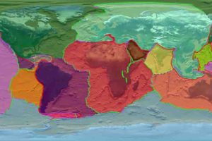
A combined image of Earth’s plates and their boundaries. Credit: NASA/Goddard Space Flight Center Scientific Visualization Studio
A new study suggests that plate tectonics—a scientific theory that divides the earth into large chunks of crust that move slowly over hot viscous mantle rock—could have been active from the planet’s very beginning. The new findings defy previous beliefs that tectonic plates were developed over the course of billions of years.
The paper, published in Earth and Planetary Science Letters, has important implications in the fields of geochemistry and geophysics. For example, a better understanding of plate tectonics could help predict whether planets beyond our solar system could be hospitable to life.
“Plate tectonics set up the conditions for life,” said Nick Dygert, assistant professor of petrology and geochemistry in UT’s Department of Earth and Planetary Sciences and coauthor of the study. “The more we know about ancient plate tectonics, the better we can understand how Earth got to be the way it is now.”
For the research, Dygert and his team looked into the distribution of two very specific noble gas isotopes: Helium-3 and Neon-22. Noble gases are those that don’t react to any other chemical element.
Previous models have explained the Earth’s current Helium-3/Neon-22 ratio by arguing that a series of large-scale impacts (like the one that produced our moon) resulted in massive magma oceans, which degassed and incrementally increased the ratio of the Earth each time.
However, Dygert believes the scenario is unlikely.
“While there is no conclusive evidence that this didn’t happen,” he said, “it could have only raised the Earth’s Helium-3/Neon-22 ratio under very specific conditions.”
Instead, Dygert and his team believe the Helium-3/Neon-22 ratio raised in a different way.
As the Earth’s crust is continuously formed, the ratio of helium to neon in the mantle beneath the crust increases. By calculating this ratio in the mantle beneath the crust, and considering how this process would affect the bulk Earth over long periods of time, a rough timeline of Earth’s tectonic plate cycling can be established.
“Helium-3 and Neon-22 were produced during the formation of the solar system and not by other means,” Dygert said. “As such, they provide valuable insight into Earth’s earliest conditions and subsequent geologic activity.”
Reference:
Nick Dygert et al, Plate tectonic cycling modulates Earth’s 3 He/ 22 Ne ratio, Earth and Planetary Science Letters (2018). DOI: 10.1016/j.epsl.2018.06.044
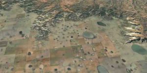
In the Panhandle of Texas – here an area near Silverton – one can witness how the High Plains, dotted with lakes, gradually erode at the edges. Source: Google Earth / Landsat / Copernicus
Starting at the eastern foot of the Rocky Mountains in the midwest United States, the dramatic landscape of the High Plains stretches across several US states. Dropping just a few hundred meters over a length of more than 500 kilometres, these plains have only a very gentle gradient and the nearly flat surfaces exhibit unique ecosystems, making them a geological and ecological anomaly.
In the High Plains there are hundreds of thousands of small ephemeral lakes known as playas, that are filled with rainwater only during wet seasons, drying out completely during dry periods. The lakes provide an important breeding, resting and wintering habitat for millions of birds and also supply recharge to the groundwater reservoir known as the Ogallala aquifer. At 450,000 square kilometres, it is the largest aquifer in North America. Without these groundwater resources, agriculture in this dry region would be nearly impossible.
By no means a geological bore
Geologists have given little attention to the High Plains in recent times. “For alpine geologists used to working in high mountains, the region is too flat and considered uninteresting,” says Sean Willett, a professor of geology at ETH Zurich, with a chuckle. It was by chance that he and his two colleagues from the University of Nevada developed an interest in the region when they noticed “peculiar patterns of streams” crossing the High Plains. They have now published their reconstruction of the region’s unusual geological history in “Nature.”
The High Plains were formed 20 million years ago. Earth scientists have recently discovered a zone of unusually hot material in the Earth’s mantle that creates a wave of uplift that is slowly shifting from west to east under the continental plate. This wave first uplifted the Colorado Plateau, then the Rockies and finally the plains themselves. This resulted in a steeper gradient of the mountains towards the plains, accelerating erosion. For 15 million years, a massive flow of sediment poured out of the mountains, down the river valleys and into the plains.
Sediment transported by the rivers was deposited to form huge alluvial fans at the foot of the mountains. Gravel and coarse sand completely filled river valleys and all older topography, effectively repaving the landscape to form the gentle slopes of the modern high plains.
Lakes with limestone sealant
Because alluvial fans only have a very low gradient, rivers flowing down its surface lack erosive power. The surface of these plains sealed with sand, mud and clay, thus making it possible for rain water to remain in sinks to form lakes. Chemical processes eventually led to a calcification of the lakebeds and soils, forming limestone layers up to 10 meters thick. Finally, as it aged, cracks formed in the limestone, allowing water to seep through and feed a groundwater reservoir of vast area and volume, hosted in the gravels shed from the mountains.
The flow of sediment finally stopped around three to five million years ago. Since then, the High Plains’ surfaces have changed very little (with the exception of human impact). “They are a preserved ancient landscape,” says Willett.
Rivers flowing from the Rocky Mountains did, however, seek out new paths and carved deeper into the subsurface along the edges of the prehistoric alluvial fans. This inexorable process is still underway: the rivers continue to erode the alluvial fans, which is evident in the formation of escarpments and badlands with dendritic patterns of streams and rivers cutting into the plateaus of the High Plains. “What we are seeing today is a landscape in transition,” the ETH professor points out. “It will take five or ten million years until the High Plains have completely eroded.”
An unstoppable disintegration of the alluvial fans
Willet does not see any immediate threat to the groundwater supply. However, people should be aware that the forces breaking down the High Plains are responsible for where groundwater is found today and where agriculture is possible.
There is nowhere else in the world quite like the High Plains. There are, of course, gigantic alluvial plains in South America as well, and in the part of the Himalayas located in India. “But the High Plains have been inactive for nearly five million years, whereas the other large alluvial fans are still in the process of formation,” says the researcher.
Reference:
Sean D. Willett, Scott W. McCoy, Helen W. Beeson. Transience of the North American High Plains landscape and its impact on surface water. Nature, 2018; 561 (7724): 528 DOI: 10.1038/s41586-018-0532-1
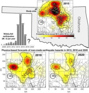
This image shows widely-felt earthquakes that struck north-central Oklahoma and southern Kansas and the probability that those areas will experience potentially damaging induced earthquakes in 2018 and 2020. Manmade earthquakes in this region are caused by deep injection of wastewater from oil and gas operations. Credit: Cornelius Langenbruch
Earthquakes in Oklahoma and Kansas had been on the rise due to injection of wastewater — a byproduct of oil and gas operations — before regulations started limiting injections. Now a new model developed by Stanford University researchers incorporates earthquake physics and the Earth’s hydrogeologic response to wastewater injection to forecast a decrease in human-made earthquakes in Oklahoma and Kansas through 2020.
The model is based on publicly available data on wastewater injection into the Arbuckle formation, a nearly 7,000-foot-deep sedimentary formation underlying north-central Oklahoma and southern Kansas. Assuming wastewater injection from oil and gas operations continues at its current rate, researchers mapped the likelihood that the region will experience future earthquakes. The research appears Sept. 26 in the journal Nature Communications.
“We’ve created a detailed model that allows regulators to know where most of the problems are likely to occur,” said co-author Mark Zoback, the Benjamin M. Page Professor of Geophysics at Stanford’s School of Earth, Energy & Environmental Sciences (Stanford Earth). “This can be used in Oklahoma, or elsewhere, to provide a scientific basis for regulatory action.”
Local insights
Oil and gas operations often produce large volumes of salty water that they dispose of by injecting it deep underground to protect water in aquifers near the surface used for drinking, livestock and irrigation.
Fluid injected into the Arbuckle formation increases pressure that spreads over a large area. This pressure is problematic because it can affect large faults nearby that are already under stress from tectonic processes. These faults are capable of producing widely felt and potentially damaging earthquakes, if reached by the pressure increase caused by injection.
The same pressure increase in different areas can cause up to 100 times the number of earthquakes, according to lead author Cornelius Langenbruch, a postdoctoral researcher at Stanford Earth. The earthquakes are not necessarily concentrated in areas where the pressure change is highest. In order to understand where earthquakes will or will not occur on a local scale, the new model evaluates the pressure increase in the context of the area’s vulnerable, pre-existing faults.
“It was surprising for me to see that the local susceptibility to earthquakes fluctuates by such a large amount,” Langenbruch said. “The example of Oklahoma shows that the key to managing seismic hazards related to these human-made, induced earthquakes is managing how much and where the wastewater is injected.”
Mandated reduction
Oklahoma’s induced earthquakes increased drastically around 2009 and peaked in 2015, with nearly 1,000 widely felt earthquakes spread across the northern and central parts of the state. Oklahoma’s public utilities commission, the Oklahoma Corporation Commission, mandated a 40 percent water injection reduction in early 2016 and the number of earthquakes declined thereafter.
The new model — which includes data from 809 injection wells from 2000 through 2018 — shows there will be a 32 percent, 24 percent and 19 percent probability of potentially damaging earthquakes of magnitude 5.0 or above in 2018, 2019 and 2020, respectively, suggesting that Oklahoma’s policies are working. If current injection practices in north-central Oklahoma and southern Kansas continue, one potentially damaging magnitude 5.0 or larger earthquake is expected to occur through 2020.
“The result of the new study is definitely good news — it shows injection rate reductions are still effective. In 2015 and 2016 the probabilities were as high as 70 percent,” Langenbruch said. “However, the problem is that earthquake probabilities in some areas are still much higher than historic rates.”
Future scenarios
The predictive maps from the study allow residents of Oklahoma and Kansas to see the probability that potentially damaging earthquakes will strike close to their homes. The new model can also be used to evaluate future injection scenarios intended to mitigate seismic hazards.
“The nice thing about the methodology is not only the predictions it makes, but its ability to make new predictions based on new measures that might be taken by the regulators,” Zoback said. “It turns out you can do these analyses fairly early in the process.”
The researchers hope this model will also be used in other areas with expanding oil and gas operations. Places like the Permian Basin in West Texas are being developed at an incredible rate and water injection is probably resulting in earthquakes in that area already, Zoback said.
A co-author of the paper is Matthew Weingarten, an assistant professor at San Diego State University who conducted research for the study as a postdoctoral researcher at Stanford. Zoback is also a senior fellow at Stanford’s Precourt Institute for Energy, an affiliate of the Stanford Woods Institute for the Environment and the director of the Stanford Natural Gas Initiative. Funding for the study was provided by the Stanford Center for Induced and Triggered Seismicity (SCITS), an industrial affiliates program involving 10 Stanford professors.
Reference:
Cornelius Langenbruch, Matthew Weingarten, Mark D. Zoback. Physics-based forecasting of man-made earthquake hazards in Oklahoma and Kansas. Nature Communications, 2018; 9 (1) DOI: 10.1038/s41467-018-06167-4
This is an illustration of the research finds by Sae Bom Ra, an Adelphi University scientific illustration major. Credit: Sae Bom Ra/Adelphi University
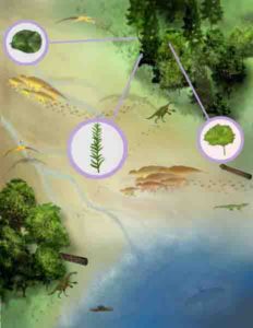
A newly discovered fossil suggests that large, flowering trees grew in North America by the Turonian age, showing that these large trees were part of the forest canopies there nearly 15 million years earlier than previously thought. Researchers from Adelphi University and the Burpee Museum of Natural History found the fossil in the Mancos Shale Formation in Utah, in ancient delta deposits formed during a poorly understood interval in the North American fossil record.
“These discoveries add much more detail to our picture of the landscape during the Turonian period than we had previously,” says Michael D’Emic, assistant professor of biology at Adelphi, who organized the study. “Since Darwin, the evolution of flowering plants has been a topic of debate for paleontologists because of their cryptic fossil record. Our paper shows that even today it is possible for a single fossil specimen to change a lot about what we know about the early evolution of the group.
“Understanding the past is the key to managing the future,” D’Emic added. “Learning how environments evolved and changed in the past teaches us how to better prepare for future environmental change.”
Aside from the large petrified log, the team reports fossilized foliage from ferns, conifers and angiosperms, which confirm that there was forest or woodland vegetation 90 million years ago in the area, covering a large delta extending into the sea. The team also reports the first turtle and crocodile remains from this geologic layer, as well as part of the pelvis of a duck-billed dinosaur; previously, the only known vertebrate remains found were shark teeth, two short dinosaur trackways, and a fragmentary pterosaur.
“Until now most of what we knew about plants from the Ferron Sandstone came from fossil pollen and spores,” says Nathan Jud, co-author and assistant professor of biology at William Jewell College. “The discovery of fossil wood and leaves allows us to develop a more complete picture of the flora.”
Reference:
Nathan A. Jud, Michael D. D’emic, Scott A. Williams, Josh C. Mathews, Katie M. Tremaine, and Janok Bhattacharya. A new fossil assemblage shows that large angiosperm trees grew in North America by the Turonian (Late Cretaceous). Science Advances, 2018 DOI: 10.1126/sciadv.aar8568
Note: The above post is reprinted from materials provided by Adelphi University.
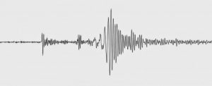
Careful analysis of data collected after the 3 September 2017 North Korean declared nuclear test explosion has allowed seismologists to distinguish the separate seismic signatures of the explosion, a collapse of the explosion cavity and even several small earthquakes that occurred after the collapse.
The data, compared with those collected from 20th-century Nevada nuclear test sites, can help refine seismologists’ methods of identifying nuclear test explosions around the world, write William R. Walter and his colleagues at Lawrence Livermore National Laboratory. Their paper is published as part of a special focus section on the September 2017 North Korean explosion and its aftermath in the journal Seismological Research Letters.
The September 2017 body-wave magnitude 6.1 underground test by the Democratic People’s Republic of Korea (DPRK) is the largest such test in more than 20 years, and is the sixth declared nuclear test by the DPRK since 2006. The September explosion is an order of magnitude larger than the next largest test by the country, which occurred in September 2016.
The researchers used a method that compares the ratio between regional P- and S-wave amplitudes to distinguish the seismic signature of an explosion compared to an earthquake, at distances about 200 to 1500 kilometers away from the seismic wave source. (P-waves compress rock in the same direction as the seismic wave’s movement, while S-waves move rock perpendicular to the direction of the wave.) “In the P/S ratio discriminant we use to identify explosions, it is the lack of S-waves at high frequency that is distinctive of the explosions,” Walter explained.
Walter and colleagues showed that the ratio could separate the six North Korean declared nuclear tests from natural earthquakes in the region, and that the same method could be used to successfully distinguish between historic Nevada Test Site nuclear explosions and earthquakes in the western United States.
However, there was another unusual seismic event, occurring about eight and half minutes after the explosion, which also drew the attention of the seismologists. Models of seismic waveforms of the event led the scientists to conclude that the event may have been the ground collapsing around an underground cavity left by the explosion.
Although collapses similar to this were sometimes seen after Nevada Test Site explosions, “this is the first time, to my knowledge, that we have remotely observed seismic waves from a collapse with modern instrumentation at a foreign test site,” said Walter. “It is important to be able to determine this collapse was not another nuclear test.”
Several features of the post-explosion event’s waveforms mark it as a collapse rather than an explosion, the researchers say, including the relative lack of high frequency energy compared to explosion waveforms.
“Identifying the event as a collapse is another indicator the 3 September 2017 event was a nuclear test that generated a large vaporization cavity that collapsed eight and half minutes later,” said Walter. “But we want to continue to develop methods to identify collapses to distinguish them from both explosions and earthquakes.”
Researchers studying the September 2017 nuclear test data also noted two smaller seismic events occurring after the explosion, of magnitudes 2.6 and 3.4, that appear from the P- to S-wave ratios to be small earthquakes located four to eight kilometers north of the explosion site.
“We had not remotely observed any aftershocks from the prior DPRK declared nuclear tests, so the earthquakes following the explosion got people’s attention,” Walter said. “Again, we wanted to determine they were not additional smaller nuclear tests. Alternatively, we wanted to determine they were not associated with the collapse event.” Upon careful re-analysis of the continuous data the researchers found a number of additional small earthquakes, including some that occurred before the 3 September 2017 declared nuclear test.
Given the timing these earthquakes do not appear to be true “aftershocks” of the nuclear test, Walter and colleagues concluded, though they may be related and possibly induced by the explosion. “The fact that apparent tectonic earthquakes are occurring near the DPRK test site reveals information about the state of [seismic] stress in the region, which may help us better understand the explosion seismic signatures,” said Walter.
Reference:
Andrea Chiang et al, Moment Tensor Source‐Type Analysis for the Democratic People’s Republic of Korea–Declared Nuclear Explosions (2006–2017) and 3 September 2017 Collapse Event, Seismological Research Letters (2018). DOI: 10.1785/0220180130
The epicenter of the 3 September 2017 nuclear test explosion in North Korea occurred about 3.6 kilometers northwest of the country’s first nuclear test in October 2006, according to a new high-precision analysis of the explosion and its aftermath.
The study published in Seismological Research Letters by Lian-Feng Zhao of the Chinese Academy of Sciences and colleagues used regional seismic data collected from a number of sources to locate the 2017 test, and to confirm that subsequent seismic events were not also nuclear explosions.
Their paper is published as part of the journal’s special focus section on the September 2017 North Korean explosion. The body-wave magnitude 6.1 underground test by the Democratic People’s Republic of Korea (DPRK) is the largest such test in more than 20 years, and is the sixth declared nuclear test by the DPRK since 2006. The September explosion is an order of magnitude larger than the next largest test by the country, which occurred in September 2016.
Zhao and colleagues used seismic wave data from 255 seismograph stations in the China National Digital Seismic Network, Global Seismic Network, International Federation of Digital Seismograph Networks and Full Range Seismograph Network in Japan to investigate the explosion and three other seismic events that occurred in the minutes and days after.
Although global seismic networks may pick up the signal of underground nuclear tests, the signals they detect are often too weak to be to be used in the kind of location analysis performed by Zhao and colleagues. “The closer to the sources the better,” said Zhao. “However, seismometers cannot be deployed in the North Korean test site due to political issues. Thus, seismologists have developed methods that can be applied to regional seismic data to investigate seismic characteristics of the underground nuclear explosions.”
The researchers used seismic data from the first DPRK nuclear test as the “master event” to calibrate their location analysis, since the epicenter of that small explosion could be visually located using satellite images of localized ground surface damage. The much larger September 2017 explosion produced surface damage over an area about nine square kilometers, however, in ground that was already disturbed by previous nuclear tests. “For example, after the sixth North Korean nuclear test, large displacements occurred on the west and south flank [of the test site] and debris flows were localized in pre-existing channels,” Zhao explained. “These spatially distributing phenomena made it difficult for us to directly determine the epicenter of the explosion.”
Zhao and colleagues used regional seismic data instead to calculate that the epicenter of the September 2017 explosion was at 41.3018°N and 129.0696°E. A seismic event that took place about eight minutes after the explosion occurred very close to the explosion epicenter—less than 200 meters away—and probably represents the seismic signature of the collapse of a cavity left by the underground explosion, the researchers suggested.
Two subsequent seismic events, one on 23 September and one on 12 October, were located about eight kilometers northeast of the nuclear test site. Zhao and colleagues said that the seismic signatures of these two events indicate that they are not explosions, but may have resulted from mechanisms such as landslide or ground collapse. They may also be very shallow natural earthquakes that were triggered by the explosion, they noted, a possibility that will require more research on the pre- and post-explosion stresses on the faults where the events occurred.
Reference:
“High-precision Relocation and Event Discrimination for the September 3, 2017 Underground Nuclear Explosion and Subsequent Seismic Events at North Korean Test Site,” DOI: 10.1785/0220180164
All gems in the tourmaline family are mixed crystals of aluminium boron silicate that also contain elements such as iron, manganese, sodium, lithium, or potassium. While tourmaline was first discovered in Brazil in the 16th century, the green crystals were initially confused with emerald. It was not until the 19th century that the gem was classified as tourmaline.
Gemmologists now divide tourmalines into 11 different species depending on their properties and chemical composition. Elbaite is the name given to the most colourful members of the tourmaline mineral family. The red or pink tourmalines known as rubellites, the blue variety called indicolite and the coveted Paraiba tourmaline are all Elbaites, as is the multi-coloured watermelon tourmaline.
The term tourmaline was derived from the Singhalese phrase tura mali, meaning “stone mixed with vibrant colours”, and the watermelon prefix refers to the unique colour combination that resembles the fruit of the same name. With a Moh’s scale hardness of 7-7.5, the watermelon tourmaline is a relatively durable stone for jewellery while its distinctive and eye-catching colours mark it out as a favourite with designers.
The History of Tourmaline
The name tourmaline comes from the Singhalese words “toramalli”. These words translate as “mixed gems”. It’s believed that the first tourmalines were discovered by conquistadors in Brazil in the 1500s. At the time, these green tourmalines were assumed to be emeralds. It wasn’t until the 1800s when scientists realized that these stones were their own species of mineral.
Large deposits of tourmaline have been found stateside in Maine and California. They were extremely popular stones in China, who would eagerly buy up American tourmaline specimens as they were discovered. Until 1912, the American tourmaline trade was booming. At that time, the Chinese government collapsed and the demand for the stones plummeted. The trade would pick back up when discoveries of deposits in countries like Brazil, Afghanistan, and Madagascar renewed interest in these multicolored beauties.
Where is watermelon tourmaline found?
Brazil, Nigeria, Madagascar, Afghanistan and the United States all produce watermelon tourmalines. The North American state of Maine, where the gem was first discovered at a mine in Newry in 1902, is renowned for its stunning watermelon tourmaline. In the early 1970s, a large pocket of some of the finest watermelon tourmalines ever seen was unearthed at the nearby Plumbago Gem Pit.
Brazil is also famous for its gem-quality watermelon tourmalines, with amazingly clear and vibrant colours. Gem dealer Matthew Morrell of Direct Source Gems says the most abundant sources of classic red/green watermelon tourmalines are the Araçuaí and São José da Safira regions of Minas Gerais in Brazil.
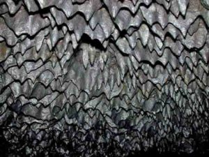
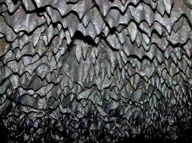
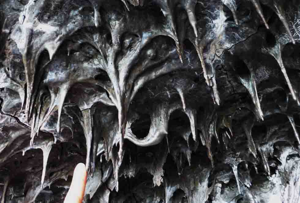
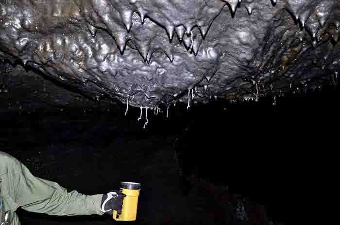
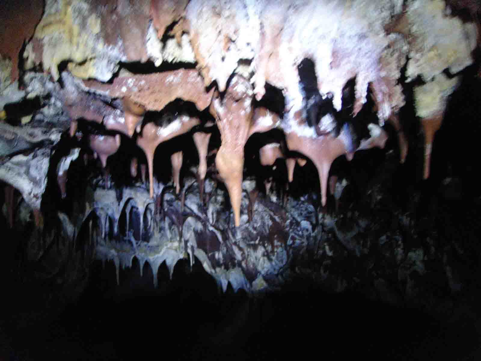
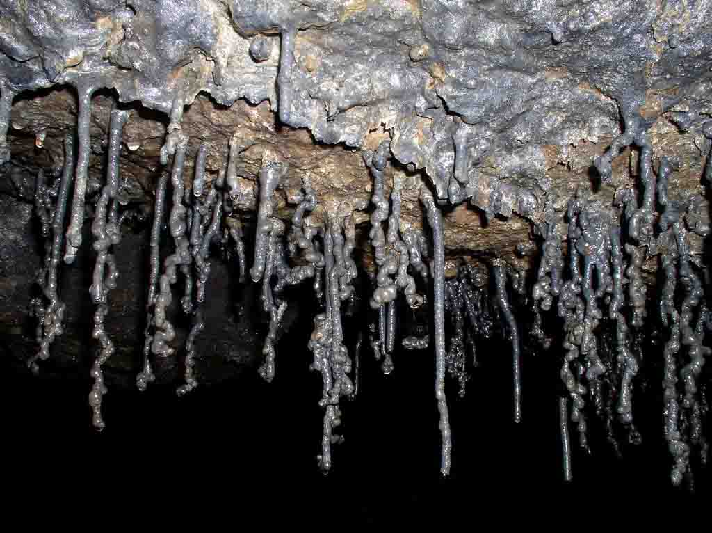
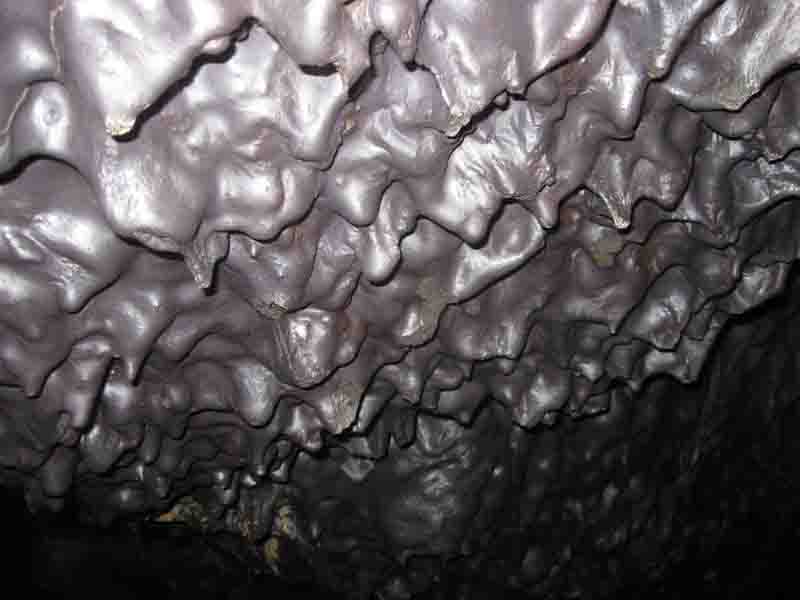
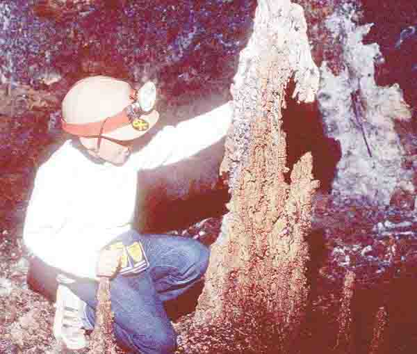
A geological formation consisting of a quantity of lava that dripped from the roof of a cave as it cooled and hardened, leaving a rounded protrusion.
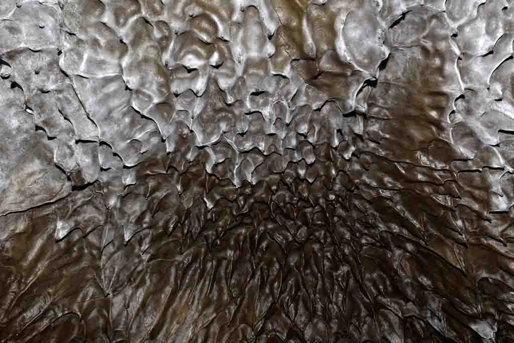
Lavacicles are small round-tipped stalactites that are found in lava tubes, the name comes from their resemblance to icicles. Lavacicle is really a generic term that encompasses several different types of stalactites found in lava tubes, which differ in their shape and morphology.
Geology of Lavacicle Cave
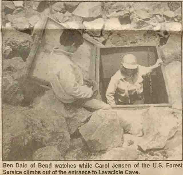
Lavacicle Cave was found by accident in 1959 by firefighter, Max Stenkamp. Lavacicle revealed itself with a strong draft of air that ascended through the smoke of the Aspen Flat Fire. Stenkamp and his men followed the draft, but went only as far as the lavacicles and came out dazzled by the spectacle. You’ll notice the same brisk draft that revealed the cave’s location to Stenkamp as you peer inside the entrance today but you won’t get to see any lavacicles.
Lavacicle Cave is unique because of the well-developed lava pinnacles rising from the floor. The formations resemble common stalagmites and stalactites, however, they were formed by cooling lava rather than by dripping water.
Geologists have observed that certain lava tubes served as channel ways for later lava flows. Evidence of these younger flows is seen along the walls in the form of projecting shelves and gutters, representing the various stages of flooding as the lava stream rose and fell. Apparently, Lavacicle Cave was temporarily filled to the roof by a younger flow. Immediately after this lava drained out of the tube, the molten material coating the ceiling dripped to the floor, building pinnacles of rock.
The tallest lavacicle was reported 6 feet high; hundreds of others scattered over the floor range from 1 to 2 feet in height. In contrast, lavacicles on the ceiling are only a few inches in length. Over the years many of these lavacicles have been vandalized and broken. One of the largest and most beautiful formations, the so-called Horse Head was actually stolen from the cave, never to be seen again.
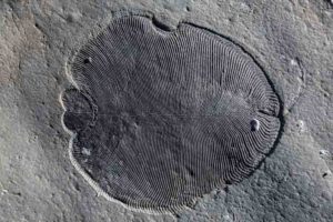
This is a Dickinsonia fossil. Credit: The Australian National University (ANU)
Scientists from The Australian National University (ANU) and overseas have discovered molecules of fat in an ancient fossil to reveal the earliest confirmed animal in the geological record that lived on Earth 558 million years ago.
The strange creature called Dickinsonia, which grew up to 1.4 metres in length and was oval shaped with rib-like segments running along its body, was part of the Ediacara Biota that lived on Earth 20 million years prior to the ‘Cambrian explosion’ of modern animal life.
ANU PhD scholar Ilya Bobrovskiy discovered a Dickinsonia fossil so well preserved in a remote area near the White Sea in the northwest of Russia that the tissue still contained molecules of cholesterol, a type of fat that is the hallmark of animal life.
Lead senior researcher Associate Professor Jochen Brocks said the ‘Cambrian explosion’ was when complex animals and other macroscopic organisms — such as molluscs, worms, arthropods and sponges — began to dominate the fossil record.
“The fossil fat molecules that we’ve found prove that animals were large and abundant 558 million years ago, millions of years earlier than previously thought,” said Associate Professor Jochen Brocks from the ANU Research School of Earth Sciences.
“Scientists have been fighting for more than 75 years over what Dickinsonia and other bizarre fossils of the Edicaran Biota were: giant single-celled amoeba, lichen, failed experiments of evolution or the earliest animals on Earth. The fossil fat now confirms Dickinsonia as the oldest known animal fossil, solving a decades-old mystery that has been the Holy Grail of palaeontology.”
Mr Bobrovskiy said the team developed a new approach to study Dickinsonia fossils, which hold the key between the old world dominated by bacteria and the world of large animals that emerged 540 million years ago during the ‘Cambrian explosion’.
“The problem that we had to overcome was finding Dickinsonia fossils that retained some organic matter,” said Mr Bobrovskiy from the ANU Research School of Earth Sciences.
“Most rocks containing these fossils such as those from the Ediacara Hills in Australia have endured a lot of heat, a lot of pressure, and then they were weathered after that — these are the rocks that palaeontologists studied for many decades, which explained why they were stuck on the question of Dickinsonia’s true identity.”
Palaeontologists normally study the structure of fossils, but Mr Bobrovskiy extracted and analysed molecules from inside the Dickinsonia fossil found in ancient rocks in Russia to make the breakthrough discovery.
“I took a helicopter to reach this very remote part of the world — home to bears and mosquitoes — where I could find Dickinsonia fossils with organic matter still intact,” Mr Bobrovskiy said.
“These fossils were located in the middle of cliffs of the White Sea that are 60 to 100 metres high. I had to hang over the edge of a cliff on ropes and dig out huge blocks of sandstone, throw them down, wash the sandstone and repeat this process until I found the fossils I was after.”
Associate Professor Brocks said being able to study molecules from these ancient organisms was a gamechanger.
“When Ilya showed me the results, I just couldn’t believe it,” he said.
“But I also immediately saw the significance.”
ANU led the research in collaboration with scientists from the Russian Academy of Science and the Max Planck Institute for Biogeochemistry and the University of Bremen in Germany.
Reference:
Ilya Bobrovskiy, Janet M. Hope, Andrey Ivantsov, Benjamin J. Nettersheim, Christian Hallmann, Jochen J. Brocks. Ancient steroids establish the Ediacaran fossil Dickinsonia as one of the earliest animals. Science, 2018; 361 (6408): 1246 DOI: 10.1126/science.aat7228
Reconstruction of Edaphosaurus, a primitive mammal ancestor; its long spines form a sail on its back. Credit: Harvard University Museum of Comparative Zoology
Mammals are unique in many ways. We’re warm-blooded and agile in comparison with our reptilian relatives.
But a new study, funded by the National Science Foundation (NSF) and led by Harvard University researchers Stephanie Pierce and Katrina Jones, suggests we’re unique in one more way — the makeup of our spines. The researchers describe their finding in a paper published this week in the journal Science.
“The spine is basically like a series of beads on a string, with each bead representing a single bone — a vertebra,” said Pierce, curator of vertebrate paleontology at Harvard. “In most four-legged animals, like lizards, the vertebrae all look and function the same.
“But mammal backbones are different. The different sections or regions of the spine — like the neck, thorax and lower back — take on very different shapes. They function separately and so can adapt to different ways of life, like running, flying, digging and climbing.”
While mammal backbones are specialized, the regions that underlie them were believed to be ancient, dating back to the earliest land animals.
Mammals made the most of the existing anatomical blueprint, or so scientists believed. However, the new study is challenging this idea by looking into the fossil record.
“There are no animals alive today that record the transition from a ‘lizard-like’ ancestor to a mammal,” said Jones, lead author of the study. “To do that, we have to dive into the fossil record and look at the extinct forerunners of mammals, the non-mammalian synapsids.”
These ancient ancestors hold the key to understanding the origin of mammal-specific characteristics, including the spine.
But studying fossils isn’t easy. “Fossils are scarce and finding extinct animals with all 25-plus vertebrae in place is incredibly rare,” Jones said.
To tackle this problem, the researchers combed museum collections around the world to study the best-preserved fossils of animals that lived some 320 million years ago.
“Looking into the ancient past, an early change in mammals’ spinal columns was an important first step in their evolution,” said Dena Smith, a program director in NSF’s Division of Earth Sciences, which funded the research. “Changes in the spine over time allowed mammals to develop into the myriad species we know today.”
Pierce and Jones, along with co-author Ken Angielczyk of the Field Museum in Chicago, examined dozens of fossil spines, as well as more than 1,000 vertebrae of living animals, including mice, alligators, lizards and amphibians.
They wanted to find out whether mammal vertebral regions were as ancient as previously thought, or if mammals were doing something unique.
“If vertebral regions had remained unchanged through evolution, as hypothesized, we would expect to see the same regions in the non-mammalian synapsids that we see in mammals today,” said Pierce.
But that doesn’t seem to be the case. When the researchers compared the positioning and shape of the vertebrae, they found something surprising. The spine had gained new regions during mammal evolution.
“The earliest non-mammalian synapsids had fewer regions than living mammals,” said Jones.
About 250 million years ago, a new region evolved near the shoulders and front legs. Dramatic changes also began to appear in the forelimbs of animals known as non-mammalian therapsids.
These simultaneous developments, the scientists believe, likely occurred in conjunction with changes in how creatures walked and ran.
“There appears to be some sort of cross-talk during development between the tissues that form the vertebrae and the shoulder blade,” Pierce said. “We think this interaction resulted in the addition of a region near the shoulder as the forelimbs of our ancestors evolved to take on new shapes and functions.”
Later, a region emerged near the pelvis. “It is this last region, the ribless lumbar region, that appears to be able to adapt the most to different environments,” said Pierce.
The final step in building the mammal backbone may be linked with changes in Hox genes, important to spine regions early in their development.
“We’ve been able to make connections among changes in the skeletons of extinct animals and ideas in modern developmental biology and genetics,” Jones said. “This combined approach is helping us understand what makes a mammal a mammal.”
Reference:
K. E. Jones, K. D. Angielczyk, P. D. Polly, J. J. Head, V. Fernandez, J. K. Lungmus, S. Tulga, S. E. Pierce. Fossils reveal the complex evolutionary history of the mammalian regionalized spine. Science, 2018; 361 (6408): 1249 DOI: 10.1126/science.aar3126
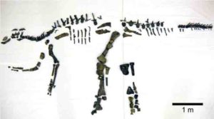
The unearthed bones of Mukawaryu, Japan’s largest complete dinosaur skeleton, have now been prepared and pieced together, giving us a fuller and clearer image of the 72 million-year-old dinosaur.
Excavations of Mukawaryu, the largest complete dinosaur skeleton in Japan, began in 2013 in the Hobetsu district of Mukawa Town on Japan’s northernmost island of Hokkaido by the Hokkaido University Museum and Hobetsu Museum research teams. Although many bones have not yet been identified, the majority have been, and those which can be pieced together now present a more accurate depiction of the dinosaur’s anatomy.
Mukawaryu was recovered from marine deposits dating back to the Late Cretaceous Period around 72 million years ago. The skeleton has been identified as a duck-billed dinosaur (Hadrosauridae). These herbivores thrived in Eurasia, North and South America, and Antarctica.
The Mukawaryu skeleton revealed in 2017 was defined as a complete skeleton, as it contained more than 50 percent of the bones, but now an estimated 60 percent of the bones have been confirmed as well as 80 percent of the entire expected skeletal volume. With a significant amount of cranial bones pieced together in addition to more shoulder, forelimb, hip, hindlimb, and backbones, the skeleton is now more discernible.
“There are still many unidentified bones and fossils that need to be restored,” said Associate Professor Yoshitsugu Kobayashi of the research team. “We will continue researching Mukawaryu, analyzing its bones, and unraveling more details of this creature. We also hope to further clarify its systematic position, determine any related species and the ecology of the environment it lived in.”
The observed direction of polar motion, shown as a light blue line, compared with the sum (pink line) of the influence of Greenland ice loss (blue), postglacial rebound (yellow) and deep mantle convection (red). The contribution of mantle convection is highly uncertain. Credit: NASA/ JPL-Caltech
A typical desk globe is designed to be a geometric sphere and to rotate smoothly when you spin it. Our actual planet is far less perfect — in both shape and in rotation.
Earth is not a perfect sphere. When it rotates on its spin axis — an imaginary line that passes through the North and South Poles — it drifts and wobbles. These spin-axis movements are scientifically referred to as “polar motion.” Measurements for the 20th century show that the spin axis drifted about 4 inches (10 centimeters) per year. Over the course of a century, that becomes more than 11 yards (10 meters).
Using observational and model-based data spanning the entire 20th century, NASA scientists have for the first time identified three broadly-categorized processes responsible for this drift — contemporary mass loss primarily in Greenland, glacial rebound, and mantle convection.
“The traditional explanation is that one process, glacial rebound, is responsible for this motion of Earth’s spin axis. But recently, many researchers have speculated that other processes could have potentially large effects on it as well,” said first author Surendra Adhikari of NASA’s Jet Propulsion Laboratory in Pasadena, California. “We assembled models for a suite of processes that are thought to be important for driving the motion of the spin axis. We identified not one but three sets of processes that are crucial — and melting of the global cryosphere (especially Greenland) over the course of the 20th century is one of them.”
In general, the redistribution of mass on and within Earth — like changes to land, ice sheets, oceans and mantle flow — affects the planet’s rotation. As temperatures increased throughout the 20th century, Greenland’s ice mass decreased. In fact, a total of about 7,500 gigatons — the weight of more than 20 million Empire State Buildings — of Greenland’s ice melted into the ocean during this time period. This makes Greenland one of the top contributors of mass being transferred to the oceans, causing sea level to rise and, consequently, a drift in Earth’s spin axis.
While ice melt is occurring in other places (like Antarctica), Greenland’s location makes it a more significant contributor to polar motion.
“There is a geometrical effect that if you have a mass that is 45 degrees from the North Pole — which Greenland is — or from the South Pole (like Patagonian glaciers), it will have a bigger impact on shifting Earth’s spin axis than a mass that is right near the Pole,” said coauthor Eric Ivins, also of JPL.
Previous studies identified glacial rebound as the key contributor to long-term polar motion. And what is glacial rebound? During the last ice age, heavy glaciers depressed Earth’s surface much like a mattress depresses when you sit on it. As that ice melts, or is removed, the land slowly rises back to its original position. In the new study, which relied heavily on a statistical analysis of such rebound, scientists figured out that glacial rebound is likely to be responsible for only about a third of the polar drift in the 20th century.
The authors argue that mantle convection makes up the final third. Mantle convection is responsible for the movement of tectonic plates on Earth’s surface. It is basically the circulation of material in the mantle caused by heat from Earth’s core. Ivins describes it as similar to a pot of soup placed on the stove. As the pot, or mantle, heats, the pieces of the soup begin to rise and fall, essentially forming a vertical circulation pattern — just like the rocks moving through Earth’s mantle.
With these three broad contributors identified, scientists can distinguish mass changes and polar motion caused by long-term Earth processes over which we have little control from those caused by climate change. They now know that if Greenland’s ice loss accelerates, polar motion likely will, too. The paper was recently published in the journal Earth and Planetary Science Letters.
Reference:
Surendra Adhikari, Lambert Caron, Bernhard Steinberger, John T. Reager, Kristian K. Kjeldsen, Ben Marzeion, Eric Larour, Erik R. Ivins. What drives 20th century polar motion? Earth and Planetary Science Letters, 2018; 502: 126 DOI: 10.1016/j.epsl.2018.08.059
The diamond anvil in which samples of magnesiowüstite were placed under extreme pressure and studied. Credit: Jennifer Jackson/Caltech
Nearly 1,800 miles below the earth’s surface, there are large odd structures lurking at the base of the mantle, sitting just above the core. The mantle is a thick layer of hot, mostly plastic rock that surrounds the core; atop the mantle is the thin shell of the earth’s crust. On geologic time scales, the mantle behaves like a viscous liquid, with solid elements sinking and rising through its depths.
The aforementioned odd structures, known as ultra-low velocity zones (ULVZs), were first discovered in 1995 by Caltech’s Don Helmberger. ULVZs can be studied by measuring how they alter the seismic waves that pass through them. But observing is not necessarily understanding. Indeed, no one is really sure what these structures are.
ULVZs are so-named because they significantly slow down the speeds of seismic waves; for example, they slow down shear waves (oscillating seismic waves capable of moving through solid bodies) by as much as 30 percent. ULVZs are several miles thick and can be hundreds of miles across. Several are scattered near the earth’s core roughly beneath the Pacific Rim. Others are clustered underneath North America, Europe, and Africa.
“ULVZs exist so deep in the inner earth that they are impossible to study directly, which poses a significant challenge when trying to determine what exactly they are,” says Helmberger, Smits Family Professor of Geophysics, Emeritus.
Earth scientists at Caltech now say they know not just what ULVZs are made of, but where they come from. Using experimental methods at high pressures, the researchers, led by Professor of Mineral Physics Jennifer Jackson, have found that ULVZs consist of chunks of a magnesium/iron oxide mineral called magnesiowüstite that could have precipitated out of a magma ocean that is thought to have existed at the base of the mantle millions of years ago.
The other leading theory for ULVZs formation had suggested that they consist of melted material, some of it possibly leaking up from the core.
Jackson and her colleagues, who reported on their work in a recent paper in the Journal of Geophysical Research: Solid Earth, found evidence supporting the magnesiowüstite theory by studying the mineral’s elastic (or seismic) anisotropy; elastic anisotropy is a variation in the speed at which seismic waves pass through a mineral depending on their direction of travel.
One particularly unusual characteristic of the region where ULVZs exist—the core-mantle boundary (CMB)—is that it is highly heterogenous (nonuniform in character) as well as anisotropic. As a result, the speed at which seismic waves travel through the CMB varies based not only on the region that the waves are passing through but on the direction in which those waves are moving. The propagation direction, in fact, can alter the speed of the waves by a factor of three.
“Previously, scientists explained the anisotropy as the result of seismic waves passing through a dense silicate material. What we’re suggesting is that in some regions, it is largely due to the alignment of magnesiowüstite within ULVZs,” says Jackson.
At the pressures and temperatures experienced at the earth’s surface, magnesiowüstite exhibits little anisotropy. However, Jackson and her team found that the mineral becomes strongly anisotropic when subjected to pressures comparable to those found in the lower mantle.
Jackson and her colleagues discovered this by placing a single crystal of magnesiowüstite in a diamond anvil cell, which is essentially a tiny chamber located between two diamonds. When the rigid diamonds are compressed against one another, the pressure inside the chamber rises. Jackson and her colleagues then bombarded the sample with x-rays. The interaction of the x-rays with the sample acts as a proxy for how seismic waves will travel through the material. At a pressure of 40 gigapascals—equivalent to the pressure at the lower mantle—magnesiowüstite was significantly more anisotropic than seismic observations of ULVZs.
In order to create objects as large and strongly anisotropic as ULVZs, only a small amount of magnesiowüstite crystals need to be aligned in one specific direction, probably due to the application of pressure from a strong outside force. This could be explained by a subducting slab of the earth’s crust pushing its way to the CMB, Jackson says. (Subduction occurs at certain boundaries between earth’s tectonic plates, where one plate dives below another, triggering volcanism and earthquakes.)
“Scientists are still in the process of discovering what happens to the crust when it’s subducted into the mantle,” Jackson says. “One possibility, which our research now seems to support, is that these slabs push all the way down to the core-mantle boundary and help to shape ULVZs.”
Next, Jackson plans to explore the interaction of subducting slabs, ULVZs, and their seismic signatures. Interpreting these features will help place constraints on processes that happened early in Earth’s history, she says.
The study is titled “Strongly Anisotropic Magnesiowüstite in Earth’s Lower Mantle.”
Reference:
Gregory J. Finkelstein et al. Strongly Anisotropic Magnesiowüstite in Earth’s Lower Mantle, Journal of Geophysical Research: Solid Earth (2018). DOI: 10.1029/2017JB015349
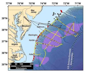
The Mid-Atlantic Resource Imaging Experiment (MATRIX) collected reflection seismic data along more than 2000 km of trackline shown in yellow. Black tracklines show transit lines where no seismic data were acquired, and orange crosses denote sonobuoy deployments. Purple areas were identified by BOEM based on legacy seismic data and show possible gas hydrate accumulations. Red symbols mark seafloor methane seeps, and the black and white circles represent exploratory wells drilled in the 1970s and 1980s. Names at the edge of the shelf refer to the major shelf-break submarine canyons. Credit: Bathymetric base map from B. Andrews.
Data acquired by the U.S. Geological Survey on the U.S. Atlantic margin in August 2018 reveal new information about the distribution of gas hydrates in the sector stretching from the upper continental slope to deep water areas offshore New Jersey to North Carolina. The Mid-Atlantic Resource Imaging Experiment (MATRIX), which was jointly sponsored by the USGS Coastal/Marine Hazards and Resources Program (CMHRP), the Methane Hydrates R&D Program at the Department of Energy, and the Bureau of Ocean Energy Management, acquired more than 2,000 kilometers (about 1,240 statute miles) of marine seismic data that image gas hydrate features and other geologic structures below the seafloor.
Gas hydrate forms naturally in seafloor sediments when methane and water combine at moderate pressures and relatively low temperatures. Gas hydrate deposits resemble ice, and they concentrate enormous amounts of methane in the global oceans and in permafrost areas. On the U.S. Atlantic margin, BOEM had previously identified potential deep water gas hydrate accumulations that guided planning for MATRIX. In fact, the sediments of deep marine continental margins host nearly 99 percent of the world’s gas hydrate.
The MATRIX data image 1 to 3 km (about 3,300 to 9,800 ft) below the seafloor and provide new information about the distribution of a key seismic indicator linked to the presence of gas hydrate. The data also reveal shallow gas deposits and structural features beneath some of the hundreds of seafloor methane seeps discovered along the Atlantic margin since 2011 and image submarine landslide deposits, shallow faults, and sedimentary markers considered important in interpreting the history of the Atlantic Ocean basin to inform assessment of geologic hazards along the eastern seaboard.
During MATRIX, USGS scientists and operational staff from CMHRP were joined by BOEM scientists, protected species visual observers, and outside technicians aboard the research vessel (R/V) Hugh R. Sharp, which is owned and operated by the University of Delaware as part of the University-National Oceanographic Laboratory System.
Up to four airguns were used to generate the acoustic energy for imaging seafloor sediments. The seismic signals were recorded by 112 to 160 receivers towed behind the ship and arrayed within a streamer up to 1.2 kilometers (0.75 miles) long. The USGS also deployed 60 sonobuoys, which are expendable instruments that receive seismic signals and transmit the information back to the ship at distances up to 15 km (9.3 miles).
Renee Orr, Chief of BOEM’s Office of Strategic Resources commented, “MATRIX presented an opportunity to acquire modern seismic data to refine understanding of gas hydrates on the U.S. Atlantic margin in areas that both BOEM and the USGS have previously identified as worthy of study.”
Lou Capitanio, program manager for DOE’s Methane Hydrates program, added that, “MATRIX also represented an important step in addressing interagency priorities to identify deep water gas hydrate deposits on U.S. marine margins.”
MATRIX Chief Scientists Carolyn Ruppel and Nathan Miller, both marine geophysicists with the USGS, credited excellent weather and a favorable Gulf Stream current as key factors in the success of the seismic cruise. Researchers acquired six seismic lines running down the continental slope from the shelf-break to waters as deep as 4,000 meters (about 13,100 ft) offshore New Jersey, Delaware, Maryland, Virginia, and North Carolina. MATRIX also completed three upper continental slope lines and three deep water (more than 2,700 meters water depth) lines oriented parallel to the coastline in this sector.
John Haines, Program Coordinator for USGS CMHRP, noted that the MATRIX effort “engaged scientific, technical, and operations staff across our USGS Program and marked the first time since the 1990s that CMHRP has independently conducted a regional-scale seismic project with airgun sources. The multiagency collaboration that contributed to the success of MATRIX is an excellent model for marine seismic programs that support mission-related research objectives.”
In addition to the scientific partnership among the USGS Gas Hydrates Project, DOE, and BOEM, MATRIX benefited from logistical support provided by Scripps Institute of Oceanography, Lamont-Doherty Earth Observatory, and the National Science Foundation. The National Marine Fisheries Service of the National Oceanic and Atmospheric Administration supported environmental compliance and permitting under the Marine Mammal Protection Act and the Endangered Species Act.
The USGS Gas Hydrates Project focuses on the energy resource potential of gas hydrates, the interaction between hydrates and the environment, and connections between gas hydrates and geohazards like submarine landslides. MATRIX produced data that will, for years to come, facilitate studies in all of these areas and support broader analyses of the margin’s hazards, stratigraphy, and deep structure by the USGS, other agencies, and the academic community.
This is a drawing of Mesosaurus. Credit: Roman Yevseyev and Graciela Piñeiro
The oldest known aquatic reptiles, the mesosaurs, probably spent part of their life on land, reveals a new study published in Frontiers in Ecology and Evolution. The fossilized bones of adult Mesosaurus share similarities with land-dwelling animals, which — coupled with the relative scarcity of land-weathered fossilized remains of large specimens — suggests that older mesosaurs were semi-aquatic, whereas juveniles spent most of their time in the water. This new research emphasizes the importance of thoroughly analyzing fossilized remains from across all stages of a reptile’s life to get a full appreciation of its lifestyle and behavior.
“Despite being considered the oldest-known fully aquatic reptile, mesosaurs share several anatomical features with terrestrial species,” says Professor Graciela Piñeiro, who completed this research at the Facultad de Ciencias, Universidad de la República, Uruguay. “Our comprehensive analysis of the vertebrae and limbs of these ancient reptiles suggests they lived in the water during the earliest stages of their development, whereas mature adults spent more time on land.”
Since the discovery of unusually large Mesosaurus bones in the Mangrullo Formation of Uruguay, Piñeiro and her international team of colleagues wondered why the larger, presumably adult specimens, around two meters in length, were not as abundant as mesosaur skeletons of around 90 cm.
“The larger specimens, at least twice the length of the more commonly reported Mesosaurus fossils, could just be exceptionally big individuals. However, the environmental conditions of the Mangrullo lagoon of where they lived were harsh, making it difficult for the occasional mesosaur to reach such a relatively large size and age,” explains Piñeiro.
She continues, “We then realized that in comparison to the smaller, better-preserved specimens, larger Mesosaurus fossils were almost always disarticulated, very weathered and badly preserved. This suggested these larger specimens had extended exposure to the air when they died.”
During the reconstruction of a Mesosaurus skeleton and analysis of skeletons representing different life stages of this ancient reptile, the researchers examined the remains for evidence of a terrestrial, land-dwelling existence.
Terrestrial, semi-aquatic and aquatic animals show a clear difference in bone profiles, so they used morphometrics to analyze the shape of the fossilized bones. Forty Mesosaurus specimens, from juveniles to adults, were examined and their bone profiles compared to those of similar reptiles known to be aquatic or semi-aquatic, such as crocodiles and marine iguanas.
“The adult mesosaur tarsus (a cluster of bones in the ankle region) suggests a more terrestrial or amphibious locomotion rather than a fully aquatic behavior as widely suggested before,” says Pablo Núñez, also based at Universidad de la República. “Their caudal vertebrae, the tail bones, also showed similarities to semi-aquatic and terrestrial animals. This supports the hypothesis that the oldest and largest mesosaurs spent more time on land, where fossil preservation is not as good as in the subaquatic domain.”
Published as part of a special article collection on Mesosaurs, these findings have broader implications — both for future research on early prehistoric animals that laid eggs with embryonic membranes and for the understanding of reptile evolution.
Piñeiro explains, “Our study emphasizes the importance of working with fossils representing an entire population of a species, including a wide range of juveniles and adults, before establishing paleobiological interpretations on their lifestyle and behavior.”
She continues, “These findings also have important implications on the inferred lifestyle of species closely related to mesosaurs, particularly in the context of the evolution of the amniotic egg. For instance, thanks to our previous discovery of a mesosaur egg and embryos inside the mother’s body, our new findings can give support to earlier hypotheses suggesting that the amniotic egg might have appeared in aquatic or semiaquatic animals as a strategy to leave the water to avoid predation.”
Reference:
Pablo Nuñez Demarco, Melitta Meneghel, Michel Laurin, Graciela Piñeiro. Was Mesosaurus a Fully Aquatic Reptile? Frontiers in Ecology and Evolution, 2018; 6 DOI: 10.3389/fevo.2018.00109
Note: The above post is reprinted from materials provided by Frontiers.
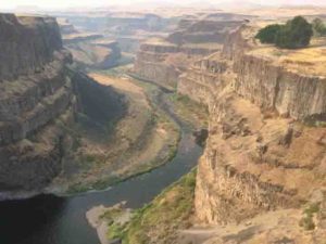
Princeton geologists Jennifer Kasbohm and Blair Schoene used tiny zircon crystals found in volcanic ash to rewrite the timeline for the eruptions of the Columbia River flood basalts, a series of massive lava flows that coincided with an ancient global warming period 16 million years ago. Palouse Falls State Park in Washington presents an excellent exposure of lava flows of the Wanapum Basalt, the second-youngest formation of the Columbia River Basalt Group. Credit: Jennifer Kasbohm, Princeton University Department of Geosciences
Imagine an enormous volcano erupting in the Pacific Northwest, pouring lava across Washington, Oregon and Idaho. Imagine the lava flooding out until river valleys are filled in. Until bushes and shrubs are buried in liquid rock. Until the tallest trees are completely covered.
About 16 million years ago, this happened.
Lava erupted in pulses, ultimately burying the region to the height of a 30-story building. If the lava had been spread evenly over the lower 48 states instead of staying concentrated in the northwest, it would cover the country to a depth of about 80 feet.
Before now, most geologists believed that it took almost 2 million years to erupt all that lava, collectively known as “the Columbia River flood basalts.” But Princeton researchers are publishing findings today that show it happened more than twice as fast as previously believed, with 95 percent erupting within a 750,000-year window.
Flood basalts have fascinated geologists for centuries. As the largest volcanic events on Earth, they have been implicated in mass extinctions, such as the largest extinction event in Earth history, 252 million years ago. There was no mass extinction 16 million years ago, but there was a major climate event about that time, known as the Mid-Miocene Climate Optimum (MMCO), a global warming event with high temperatures and elevated atmospheric carbon dioxide levels.
The same volcanoes that erupt liquid rock also belch out greenhouse gases, so geologists have wondered if there was a connection between the flood basalts and the MMCO global warming event. Just one problem: Before now, no one was quite sure about the timing of the Columbia River flood basalts.
“In order to answer the question of whether the Columbia River flood basalts caused the MMCO, we need to know the timing of eruptions and climate shifts as precisely as possible,” said Blair Schoene, associate professor of geosciences.
“To put it simply, people didn’t know exactly when or over how long the Columbia River Basalt Group erupted, which made it difficult to explore a causal relationship with the MMCO,” said Jennifer Kasbohm, a graduate student and lead author of the paper appearing today in the journal Science Advances.
To help explain the scale of the eruptions, Kasbohm drew a parallel to the 2010 Eyjafjallajökull eruption in Iceland. “The Icelandic eruption shut down airports in Europe for a week, affecting 10 million travelers, and there were periodic airline disruptions for the following month,” she said. “Now imagine having one of those Icelandic eruptions every 8 months for 750,000 years in a row, and that would give you our predicted eruption rate for the Columbia River basalts.”
Three undergraduates accompanied Kasbohm and Schoene in the lab and the field, contributing to their research while completing projects of their own: Josh Murray of the Class of 2018, Sam Bartusek ’20 and Kyle Duffey ’19. “The project involved seven weeks of fieldwork, with many days over 100 degrees Fahrenheit,” said Kasbohm. “We encountered a handful of rattlesnakes, numerous spiders, friendly and helpful locals, and we managed to stay one step ahead of the forest fires in the region.”
They were looking for zircons, tiny minerals containing trace amounts of uranium. Over time, the naturally radioactive material decays into lead, so geologists can use the ratio of uranium to lead to calculate exactly how old the zircon is. Unfortunately for geologists, basaltic lava flows like the Columbia River flood basalts don’t have the right chemistry to make zircons, so until now, geologists have had to settle for dates with uncertainties of over a million years, produced through other dating methods.
“To test for a causal link between climate and eruptions, a million years is not good enough,” said Schoene.
The researchers got around the lack of zircons in the lava rocks by looking at layers of volcanic ash between the basalt layers. The ash came from the nearby Cascade volcanoes (including Mount Saint Helens), which do contain zircon and were erupting about the same time as the massive lavas.
In their lab at Princeton, Kasbohm and Schoene separated 0.1 mm sized zircons from the 16-million-year-old rocks, measured the isotopic ratios of uranium and lead, and pinned down the ages of individual lava flows to within a few tens of thousands of years. “That precision is basically the best you can do with any chronometer for samples of this age — even though 10,000 years sounds like a lot — so our method is the gold standard,” she said.
“This is the most significant paper to come out about the Columbia River flood basalts in a decade or two,” said Stephen Reidel, a research professor of geology at Washington State University-Tri-Cities, who has studied these lava flows since 1972 and contributed to the analysis of this research. “Jenn and Blair deserve a lot of compliments for thinking to look at the zircons in the ash beds between the flows…. Of course, now we’re going to have to go back and re-calculate everything that used the old timeline or eruption rate. That’s okay — that’s part of the fun.”
With their more precise timeline, Kasbohm and Schoene have now shown that the prehistoric climate change did start very close in time to the beginning of the eruptions, but further work is needed to pin down the connection between them.
This 16-million-year-old climate change event is the last time that carbon dioxide concentrations in the atmosphere shot above 400 parts per million — until the last decade.
“The MMCO could be a parallel to our current climate, and further work investigating the timing and duration of that event will tell us more about how we can expect Earth to recover from anthropogenic climate change,” Kasbohm said. For instance, if the climate stayed warm for a million years after the volcanoes stopped erupting, as now looks possible, that could have significant implications for predicting how long the atmosphere will respond to human-caused global warming.
“Time matters,” said Kasbohm, “whether we’re trying to learn about Earth’s past or its future. It’s very empowering to use tiny minerals to tell the story of these voluminous rocks.”
Reference:
Jennifer Kasbohm, Blair Schoene. Rapid eruption of the Columbia River flood basalt and correlation with the mid-Miocene climate optimum. Science Advances, 2018; 4 (9): eaat8223 DOI: 10.1126/sciadv.aat8223
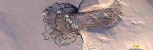
In the last few years, the Vavilov Ice Cap in the Russian High Arctic has dramatically accelerated, sliding as much as 82 feet a day in 2015, according to a new multi-national, multi-institute study led by CIRES Fellow Mike Willis, an assistant professor of Geology at CU Boulder. That dwarfs the ice’s previous average speed of about 2 inches per day and has challenged scientists’ assumptions about the stability of the cold ice caps dotting Earth’s high latitudes. Credit: Image compiled by Whyjay Zheng/Cornell University using Landsat imagery by NASA/USGS
In the last few years, the Vavilov Ice Cap in the Russian High Arctic has dramatically accelerated, sliding as much as 82 feet a day in 2015, according to a new multi-national, multi-institute study led by CIRES Fellow Mike Willis, an assistant professor of Geology at CU Boulder. That dwarfs the ice’s previous average speed of about 2 inches per day and has challenged scientists’ assumptions about the stability of the cold ice caps dotting Earth’s high latitudes.
“In a warming climate, glacier acceleration is becoming more and more common, but the rate of ice loss at Vavilov is extreme and unexpected,” said Mike Willis, CIRES Fellow and lead author of the paper published this week in Earth and Planetary Science Letters.
Glaciers and ice caps like Vavilov cover nearly 300,000 square miles of Earth’s surface and hold about a foot of potential sea-level rise. Scientists have never seen such acceleration in this kind of ice cap before, and the authors of the new paper wrote that their finding raises the possibility that other, currently stable ice caps may be more vulnerable than expected.
For the new assessment, researchers played the part of forensic ice detectives, piecing together the ice cap’s deterioration by spying on the advancing ice with remote sensing technology from a constellation of satellites operated by DigitalGlobe Inc, headquartered in Westminster, Colorado. The project also relied on support from the National Science Foundation and the National Geospatial-Intelligence Agency, which funded the development of high-resolution topographic maps of the Arctic.
By satellite, they watched ice on the cap creep slowly forward for several years, before it accelerate slowly in 2010, surging rapidly forward in 2015. The initial very slow advance is thought to have been caused by a shift in the direction of precipitation that occurred about 500 years ago. Before this time snow and rain came from the southeast, after this time rain and snow came from the southwest. As the western part of the ice cap advanced into the ocean the ice surged forward.
“Cold” ice caps, like Vavilov, occur in polar “deserts” with very little precipitation, and they’re normally frozen to their beds, flowing only due to bending of the ice under the force of gravity. With beds above sea level, they are normally insulated from the kinds of changes that have hit glaciers in less frigid regions: melting from below by warm sea water, for example, or sliding faster when warm surface meltwater drains to the bed of the ice.
Researchers suspect the ice cap began to dramatically advance when the bottom of the ice cap became wetter and the front of the glacier advanced onto very slippery marine sediments. The ice began to speed up, and friction caused some of the ice underneath the glacier to melt, which supplied more water to the bottom of the ice, reducing friction, which caused the ice to speed up, which in turn, again produced more water. Some of this water might have combined with clay underneath the glacier, reducing the friction beneath the glacier even further and allowing the truly extraordinary sliding speeds to occur.
By 2015, the sediments and rock at the bed beneath the ice had become so slippery that the material couldn’t stop the ice from flowing. It took just two years for the ice cap base to reach that tipping point, transforming into a near frictionless zone, which is well-lubricated and highly mobile. The glacier continues to slide today at accelerated speeds of 5-10 meters per day.
The Vavilov Ice Cap thinned by a total of a few meters, advanced about 2 km, and lost about 1.2 km3 in total volume into the ocean in the 30 years before the speedup. In the one year between 2015 and 2016, the ice advanced about 4 kilometers and thinned by about 100 meters (~0.3 m per day). The ice cap lost about 4.5 km3 of ice, enough to cover Manhattan with about 250 feet of water, or the entire state of Washington with an inch. And it’s unlikely the ice cap will ever be able to recover ice mass in today’s warming climate, the paper states.
Many scientists have assumed that polar ice caps that sit above sea level will only respond slowly to a warming climate — but the authors of this study urge that this assumption be questioned. The rapid collapse of the Vavilov Ice Cap has significant ramifications for glaciers in other polar regions, especially those fringing Antarctica and Greenland.
“We’ve never seen anything like this before, this study has raised as many questions as it has answered.” said Willis. “And we’re now working on modeling the whole situation to get a better handle of the physics involved.”
Reference:
Michael J. Willis, Whyjay Zheng, William J. Durkin, Matthew E. Pritchard, Joan M. Ramage, Julian A. Dowdeswell, Toby J. Benham, Robin P. Bassford, Leigh A. Stearns, Andrey F. Glazovsky, Yuri Y. Macheret, Claire C. Porter. Massive destabilization of an Arctic ice cap. Earth and Planetary Science Letters, 2018; 502: 146 DOI: 10.1016/j.epsl.2018.08.049