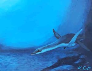
A representation of a plesiosaur – living reconstruction (representation: Kai Caspar)
In the Mesozoic era, about 250 to 65 million years ago a large number of reptiles populated the oceans. The most successful were the plesiosaurs, which existed for about the same time as the dinosaurs. Enlarged red blood cells ensured their survival. This was discovered by paleontologists at Bonn University and zoologist Kai R. Caspar from Duisburg-Essen University (UDE). The results can be read in the international bioscientific online journal PeerJ.
Why did the size of the red blood cells increase? The scientists explain this with the environment of the marine animals. “Obviously, the plesiosaur firstly developed in the open sea after their ancestors had migrated from the shallow coastal waters to the high seas. The processes in their bodies adapted accordingly,” says Kai Caspar. The enlarged red blood cells were advantageous for their longer, repeated dives in the open sea. “The larger they are, the more oxygen can be bound per cell,” says the biologist.
For their investigation, the scientists created microscopically thin sections of fossil bones of the plesiosaurs, large (ancient) marine reptiles, and compared them with those of coastal ancestors. “The pattern found is unequivocal: By moving to the high seas, the blood cell size of these marine animals increased rapidly,” summarises the UDE-scientist.
From an evolutionary perspective, this change is obviously still useful. Today`s whales, seals and penguins also have unusually large red blood cells, but their close relatives on land and in freshwater do not. “This supports our assumption that this is a significant adaption of warm-blooded marine life,” says Kai Caspar.
Reference:
Corinna V. Fleischle et al. Hematological convergence between Mesozoic marine reptiles (Sauropterygia) and extant aquatic amniotes elucidates diving adaptations in plesiosaurs, PeerJ (2019). DOI: 10.7717/peerj.8022
Margaret Mangan didn’t sleep well in the weeks following the Ridgecrest, Calif., earthquakes. The July shaking triggered a swarm of smaller tremors in the nearby Coso Volcanic Field, a cluster of lava domes and cinder cones at the northern end of the Mojave Desert. And it was Mangan’s job to watch for a possible eruption.
“We were pretty much on 24-7 vigilance,” said Mangan, the longtime scientist-in-charge of the U.S. Geological Survey’s California Volcano Observatory.
For several weeks, she personally monitored thousands of quakes via an automated alert system that pinged her phone at all hours. Occasionally, she had to wake a colleague in the middle of the night to make sure the shaking pattern didn’t point to rising magma.
California is famous for its catastrophic earthquakes and wildfires, but they are not the state’s only natural hazards. As head of the observatory, or CalVO, Mangan has drawn attention to the state’s more overlooked threats: a dozen restive volcanoes that stretch from Medicine Lake near the Oregon border to the Salton Buttes in the Coachella Valley.
“Most people are surprised that there are any volcanoes in California,” said Kari Cooper, a geologist at the University of California, Davis. “It’s just really not on people’s radar.”
It should be. According to a report Mangan and her colleagues released this year, the risk of a small-to-moderate eruption somewhere in the state over the next 30 years is 16% – about the same as for a magnitude 6.7 or greater earthquake along the San Andreas Fault.
Those odds are “not something to ignore,” she said.
For Mangan, the threat of a volcanic crisis is not merely hypothetical.
She began her career at the USGS’ Hawaii Volcano Observatory in 1990, just as Mount Kilauea began to pave over the town of Kalapana on the Big Island. It was the first time she had seen an eruption with her own eyes.
“For a volcanologist,” she said, it was “almost a religious experience.”
The event also drove home the degree of devastation a volcano can cause—and made her realize how important it is for people living in volcanically active areas to know what could happen. “I’ve seen what it can do to communities,” she said, “and the psyche of people that are faced with these things.”
Mangan came to California in the late 1990s to work at what was then called the Long Valley Volcanic Observatory.
Long Valley lies on the east side of the Sierra Nevada—the mountains themselves the roots of ancient volcanoes—and it drew scientists for good reason: In 1980, just a few days after Mount St. Helens blew its top, Mammoth Mountain started to show signs of unrest. (It eventually settled down, damaging nothing more than real estate values.)
The Long Valley research team also monitored the area’s other volcanoes, which were equally—if not more—concerning. That included the relatively young Mono Craters, which last erupted in the middle ages, and the Long Valley Caldera, which produced a supereruption that splattered ash across the southwestern U.S. 760,000 years ago.
Mangan took over the observatory in 2009. She and her staff used seismometers to listen for magma rumbling up through the crust and tracked the elevation of the ground, which can swell when magma begins to pool beneath a volcano. They also measured volcanic gases seeping through vents for clues about what was happening underground. (The answer is still not much.)
The eastern Sierra isn’t the only volcanically active region in the state. Seven other volcanoes made the most recent USGS watch list, including Mount Lassen and Mount Shasta in the north (very high-risk volcanoes); the Medicine Lake volcano, the Clearlake Volcanic Field near Napa and the Salton Buttes (high risk); and Death Valley’s Ubehebe Craters and the Coso Volcanic Field (moderate risk).
Mangan proposed bringing them all together under a unified California Volcano Observatory, and she took charge when CalVO opened in 2012.
In that role, she tried to alert people to the dangers of volcanoes while sharing her fascination with them.
“One of the reasons the state is so gorgeous is that there are volcanoes here,” she said.
In 2010, the Icelandic volcano Eyjafjallajokull produced a modest eruption. It released a quarter as much ash as Mount St. Helens, causing zero deaths and minimal damage.
But the eruption brought European air traffic to a halt for a week, stranding millions of passengers, including the mother of an employee at the California Governor’s Office of Emergency Services. It prompted the agency to realize that the same thing could happen in California—and that the state wasn’t prepared.
When CalOES asked for help, Mangan was thrilled. It was exactly the kind of thing she created CalVO to do.
Over the next few years, she led a team that assessed California’s volcanoes and the hazards they pose. The analysis contained some sobering results.
Roughly 200,000 people live in or visit the state’s volcanic hazard zones every day, and 45,000 of them are close enough to be exposed to threats like deadly blasts of hot gas and rock, lava flows, and volcanic mudslides.
Unlike earthquakes, which are over in a matter of seconds, volcanic eruptions can drag on, said Marcus Bursik, a geologist at the University of Buffalo who has worked extensively in California. “They persist for quite a long time—over years if not decades.”
As with Eyjafjallajokull, even a small paroxysm could snarl air travel. Planes regularly fly over California’s volcanoes, ferrying up to 300,000 passengers to, from and along the West Coast every day. Each year, millions more people drive through the Mount Shasta hazard zone on Interstate 5 between Redding and the Oregon border.
The indirect effects of an eruption could spread ever farther, Mangan and her colleagues found.
Thousands of miles of high-voltage power lines bound for major population centers cross through hazard zones, particularly in the northern part of the state. These could short out if covered in wet ash, leaving consumers in the dark for weeks.
A natural gas pipeline snakes between Shasta, Lassen and Medicine Lake, supplying 4.2 million homes. And many of the state’s water reservoirs lie within the ash fall zones of various volcanoes, the report noted.
“Even a small eruption in the wrong place could take out large swaths of California’s infrastructure and really cause problems for people who are hundreds of miles away,” Cooper said.
California’s Office of Emergency Services is now developing volcano response plans for the state and its vulnerable cities and counties.
“A lot of it is getting out of the way,” said Kevin Miller, manager of the earthquake, tsunami and volcano program at CalOES.
Many communities are already working on evacuation procedures for wildfires, and these could be put to use in a volcanic crisis, emergency managers say. For instance, Siskiyou County—home to Mount Shasta—has coordinated with the California Highway Patrol on a plan to commandeer both directions of I-5 if necessary.
CalOES is adding volcanoes to its MyHazards website, which allows residents to enter their address and get information about local threats, along with advice on how to deal with them.
Communities can also increase their resilience by fortifying critical equipment, like electrical substations, with protective shields and closing air intakes to keep ash out of buildings.
These efforts build on the groundwork Mangan laid over the last few years. She has crisscrossed the state, meeting with local officials to help them grasp what an eruption in their backyard would really mean.
At one stop, she persuaded Frank Frievalt to consider stronger safeguards for Mammoth Lakes, where he’s the chief of the fire protection district.
Since ash damages electronics and interferes with radio signals, Frievalt realized a top priority would be to bring in extra repeaters. “That happens all the time on wildfires,” he said. “In this case, we’d have to figure out a way to make them more resilient to an ash environment.”
Mangan has also worked with the Federal Emergency Management Agency to develop a California-specific version of its volcano crisis awareness training that includes a mock eruption exercise.
In 2015, Mangan coordinated an exchange between scientists, emergency responders and land managers in California and Chile, so they could learn from one another about the challenges of living in the shadow of active volcanoes. On their trip, the Californians witnessed the aftermath of an eruption in the town of Chaiten, where a volcano roared to life in 2008 and unleashed a mudflow that buried homes up to their windowsills.
“I’ve never been to a place that was totally decimated,” said Carolyn Napper, a ranger at the Shasta-Trinity National Forest who participated in the program.
Jim Richardson, the superintendent of Lassen Volcanic National Park, knew he was in good hands with Mangan keeping watch over his territory. (Lassen last erupted in the early 1900s, sending a slurry of melted snow and mud racing down a nearby river valley and lofting ash all the way to Elko, Nev.)
One Saturday afternoon last year, Richardson was sitting on his couch when he felt the house rattle. “That was an earthquake!” he said to his wife.
As he was checking the USGS website, he got a phone call from Mangan. There was nothing to worry about, she assured him. It was just the volcano talking in its sleep.
Richardson had come to rely on her not only for her technical expertise, but her ability to translate it into useful guidance for managers like him. “She has been our No. 1 go-to in-person person,” he said.
Starting Sunday, it will no longer be Mangan calling when a volcano shudders. She is retiring after 36 years with the USGS, including seven at the helm of CalVO.
“I’ve raised the awareness,” said Mangan, 65. Now it will be up to her successor and the state to get prepared.
Note: The above post is reprinted from materials provided by Los Angeles Times Distributed by Tribune Content Agency, LLC.
New research in Science Advances is uncovering the vital role that Precambrian-eon microbes may have played in two of the early Earth’s biggest mysteries.
University of British Columbia (UBC) researchers, and collaborators from the universities of Alberta, Tübingen, Autònoma de Barcelona and the Georgia Institute of Technology, found that ancestors of modern bacteria cultured from an iron-rich lake in Democratic Republic of Congo could have been key to keeping Earth’s dimly lit early climate warm, and in forming the world’s largest iron ore deposits billions of years ago.
The bacteria have special chemical and physical features that in the complete absence of oxygen allow them to convert energy from sunlight into rusty iron minerals and into cellular biomass. The biomass ultimately causes the production of the potent greenhouse gas methane by other microbes.
“Using modern geomicrobiological techniques, we found that certain bacteria have surfaces which allow them to expel iron minerals, making it possible for them to export these minerals to the seafloor to make ore deposits,” said Katharine Thompson, lead author of the study and PhD student in the department of microbiology and immunology.
“Separated from their rusty mineral products, these bacteria then go on to feed other microbes that make methane. That methane is what likely kept Earth’s early atmosphere warm, even though the sun was much less bright than today.”
This is a possible explanation to the ‘faint-young-sun’ paradox, originated by astronomer Carl Sagan. The paradox is that there were liquid oceans on early Earth, yet heat budgets calculated from the early Sun’s luminosity and modern atmospheric chemistry imply Earth should have been entirely frozen. A frozen Earth would not have supported very much life. A methane-rich atmosphere formed in connection to large-scale iron ore deposits and life was initially proposed by University of Michigan atmospheric scientist James Walker in 1987. The new study provides strong physical evidence to support the theory and finds that microscale bacterial-mineral interactions were likely responsible.
“The fundamental knowledge we’re gaining from studies using modern geomicrobiological tools and techniques is transforming our view of Earth’s early history and the processes that led to a planet habitable by complex life including humans,” said senior author of the paper, Sean Crowe, Canada Research Chair in Geomicrobiology and associate professor at UBC.
“This knowledge of the chemical and physical processes through which bacteria interact with their surroundings can also be used to develop and design new processes for resource recovery, novel building and construction materials, and new approaches to treating disease.”
In the future, such geo-microbiological information will likely be invaluable to large-scale geoengineering efforts that might be used to remove from CO2 from the atmosphere for carbon capture and storage, and again influence climate through bacterial mineral interactions.
Reference:
Katharine J. Thompson, Paul A. Kenward, Kohen W. Bauer, Tyler Warchola, Tina Gauger, Raul Martinez, Rachel L. Simister, Céline C. Michiels, Marc Llirós, Christopher T. Reinhard, Andreas Kappler, Kurt O. Konhauser, Sean A. Crowe. Photoferrotrophy, deposition of banded iron formations, and methane production in Archean oceans. Science Advances, 2019; 5 (11): eaav2869 DOI: 10.1126/sciadv.aav2869
Microscopic structures created in the lab. Credit: Sean McMahon
The search for evidence of life on Mars could be helped by fresh insights into ancient rocks on Earth.
Research which suggests that structures previously thought to be fossils may, in fact, be mineral deposits could save future Mars missions valuable time and resources.
Microscopic tubes and filaments that resemble the remains of tiny creatures may have been formed by chemical reactions involving iron-rich minerals, the study shows.
Previous research had suggested that such structures were among the oldest fossils on Earth.
The new findings could aid the search for extraterrestrial life during future missions to Mars by making it easier to distinguish between fossils and non-biological structures.
The discovery was made by a scientist from the University of Edinburgh who is developing techniques to seek evidence that life once existed on Mars.
Astrobiologist Sean McMahon created tiny formations in the lab that closely mimic the shape and chemical composition of iron-rich structures commonly found in Mars-like rocks on Earth, where some examples are thought to be around four billion years old.
Dr McMahon created the complex structures by mixing iron-rich particles with alkaline liquids containing the chemicals silicate or carbonate.
This process — known as chemical gardening — is thought to occur naturally where these chemicals abound. It can occur in hydrothermal vents on the seabed and when deep groundwater circulates through pores and fractures in rocks.
His findings suggest that structure alone is not sufficient to confirm whether or not microscopic life-like formations are fossils. More research will be needed to say exactly how they were formed.
The study, published in the journal Proceedings of the Royal Society B, was funded by the European Union’s Horizon 2020 programme.
Dr Sean McMahon said: “Chemical reactions like these have been studied for hundreds of years but they had not previously been shown to mimic these tiny iron-rich structures inside rocks. These results call for a re-examination of many ancient real-world examples to see if they are more likely to be fossils or non-biological mineral deposits.”
Reference:
Sean McMahon. Earth’s earliest and deepest purported fossils may be iron-mineralized chemical gardens. Proceedings of the Royal Society B: Biological Sciences, 2019; 286 (1916): 20192410 DOI: 10.1098/rspb.2019.2410
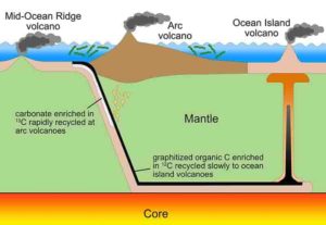
This figure illustrates how inorganic carbon cycles through the mantle more quickly than organic carbon, which contains very little of the isotope carbon-13. Both inorganic and organic carbon are drawn into Earth’s mantle at subduction zones (top left). Due to different chemical behaviors, inorganic carbon tends to return through eruptions at arc volcanoes above the subduction zone (center). Organic carbon follows a longer route, as it is drawn deep into the mantle (bottom) and returns through ocean island volcanos (right). The differences in recycling times, in combination with increased volcanism, can explain isotopic carbon signatures from rocks that are associated with both the Great Oxidation Event, about 2.4 billion years ago, and the Lomagundi Event that followed. Credit: J. Eguchi/University of California, Riverside
Earth’s breathable atmosphere is key for life, and a new study suggests that the first burst of oxygen was added by a spate of volcanic eruptions brought about by tectonics.
The study by geoscientists at Rice University offers a new theory to help explain the appearance of significant concentrations of oxygen in Earth’s atmosphere about 2.5 billion years ago, something scientists call the Great Oxidation Event (GOE). The research appears this week in Nature Geoscience.
“What makes this unique is that it’s not just trying to explain the rise of oxygen,” said study lead author James Eguchi, a NASA postdoctoral fellow at the University of California, Riverside who conducted the work for his Ph.D. dissertation at Rice. “It’s also trying to explain some closely associated surface geochemistry, a change in the composition of carbon isotopes, that is observed in the carbonate rock record a relatively short time after the oxidation event. We’re trying explain each of those with a single mechanism that involves the deep Earth interior, tectonics and enhanced degassing of carbon dioxide from volcanoes.”
Eguchi’s co-authors are Rajdeep Dasgupta, an experimental and theoretical geochemist and professor in Rice’s Department of Earth, Environmental and Planetary Sciences, and Johnny Seales, a Rice graduate student who helped with the model calculations that validated the new theory.
Scientists have long pointed to photosynthesis—a process that produces waste oxygen—as a likely source for increased oxygen during the GOE. Dasgupta said the new theory doesn’t discount the role that the first photosynthetic organisms, cyanobacteria, played in the GOE.
“Most people think the rise of oxygen was linked to cyanobacteria, and they are not wrong,” he said. “The emergence of photosynthetic organisms could release oxygen. But the most important question is whether the timing of that emergence lines up with the timing of the Great Oxidation Event. As it turns out, they do not.”
Cyanobacteria were alive on Earth as much as 500 million years before the GOE. While a number of theories have been offered to explain why it might have taken that long for oxygen to show up in the atmosphere, Dasgupta said he’s not aware of any that have simultaneously tried to explain a marked change in the ratio of carbon isotopes in carbonate minerals that began about 100 million years after the GOE. Geologists refer to this as the Lomagundi Event, and it lasted several hundred million years.
One in a hundred carbon atoms are the isotope carbon-13, and the other 99 are carbon-12. This 1-to-99 ratio is well documented in carbonates that formed before and after Lomagundi, but those formed during the event have about 10% more carbon-13.
Eguchi said the explosion in cyanobacteria associated with the GOE has long been viewed as playing a role in Lomagundi.
“Cyanobacteria prefer to take carbon-12 relative to carbon-13,” he said. “So when you start producing more organic carbon, or cyanobacteria, then the reservoir from which the carbonates are being produced is depleted in carbon-12.”
Eguchi said people tried using this to explain Lomagundi, but timing was again a problem.
“When you actually look at the geologic record, the increase in the carbon-13-to-carbon-12 ratio actually occurs up to 10s of millions of years after oxygen rose,” he said. “So then it becomes difficult to explain these two events through a change in the ratio of organic carbon to carbonate.”
The scenario Eguchi, Dasgupta and Seales arrived at to explain all of these factors is:
A dramatic increase in tectonic activity led to the formation of hundreds of volcanoes that spewed carbon dioxide into the atmosphere.
The climate warmed, increasing rainfall, which in turn increased “weathering,” the chemical breakdown of rocky minerals on Earth’s barren continents.
Weathering produced a mineral-rich runoff that poured into the oceans, supporting a boom in both cyanobacteria and carbonates.
The organic and inorganic carbon from these wound up on the seafloor and was eventually recycled back into Earth’s mantle at subduction zones, where oceanic plates are dragged beneath continents.
When sediments remelted into the mantle, inorganic carbon, hosted in carbonates, tended to be released early, re-entering the atmosphere through arc volcanoes directly above subduction zones.
Organic carbon, which contained very little carbon-13, was drawn deep into the mantle and emerged hundreds of millions of years later as carbon dioxide from island hotspot volcanoes like Hawaii.
“It’s kind of a big cyclic process,” Eguchi said. “We do think the amount of cyanobacteria increased around 2.4 billion years ago. So that would drive our oxygen increase. But the increase of cyanobacteria is balanced by the increase of carbonates. So that carbon-12-to-carbon-13 ratio doesn’t change until both the carbonates and organic carbon, from cyanobacteria, get subducted deep into the Earth. When they do, geochemistry comes into play, causing these two forms of carbon to reside in the mantle for different periods of time. Carbonates are much more easily released in magmas and are released back to the surface at a very short period. Lomagundi starts when the first carbon-13-enriched carbon from carbonates returns to the surface, and it ends when the carbon-12-enriched organic carbon returns much later, rebalancing the ratio.”
Eguchi said the study emphasizes the importance of the role that deep Earth processes can play in the evolution of life at the surface.
“We’re proposing that carbon dioxide emissions were very important to this proliferation of life,” he said. “It’s really trying to tie in how these deeper processes have affected surface life on our planet in the past.”
Dasgupta is also the principal investigator on a NASA-funded effort called CLEVER Planets that is exploring how life-essential elements might come together on distant exoplanets. He said better understanding how Earth became habitable is important for studying habitability and its evolution on distant worlds.
“It looks like Earth’s history is calling for tectonics to play a big role in habitability, but that doesn’t necessarily mean that tectonics is absolutely necessary for oxygen build up,” he said. “There might be other ways of building and sustaining oxygen, and exploring those is one of the things we’re trying to do in CLEVER Planets.”
Reference:
Great Oxidation and Lomagundi events linked by deep cycling and enhanced degassing of carbon, Nature Geoscience (2019). DOI: 10.1038/s41561-019-0492-6
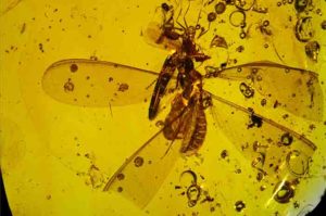
Distribution of springtails on termite and ant hosts within ~ 16 Ma old Dominican amber. Credit: N. Robin, C. D’Haese and P. Barden
When trying to better the odds for survival, a major dilemma that many animals face is dispersal — being able to pick up and leave to occupy new lands, find fresh resources and mates, and avoid intraspecies competition in times of overpopulation.
For birds, butterflies and other winged creatures, covering long distances may be as easy as the breeze they travel on. But for soil-dwellers of the crawling variety, the hurdle remains: How do they reach new, far-off habitats?
For one group of tiny arthropods called springtails (Collembola), a recent fossil discovery now suggests their answer to this question has been to piggyback on the dispersal abilities of others, literally.
In findings published in BMC Evolutionary Biology, researchers at the New Jersey Institute of Technology (NJIT) and Museum national d’Histoire naturelle have detailed the discovery of an ancient interaction preserved in 16-million-year-old amber from the Dominican Republic: 25 springtails attached to, and nearby, a large winged termite and ant from the days of the early Miocene.
The fossil exhibits a number of springtails still attached to the wings and legs of their hosts, while others are preserved as if gradually floating away from their hosts within the amber. Researchers say the discovery highlights the existence of a new type of hitchhiking behavior among wingless soil-dwelling arthropods, and could be key to explaining how symphypleonan springtails successfully achieved dispersal worldwide.
“The existence of this hitchhiking behavior is especially exciting given the fact that modern springtails are rarely described as having any interspecfic association with surrounding animals,” said Ninon Robin, the paper’s first author whose postdoctoral research at NJIT’s Department of Biological Sciences was funded by the Fulbright Program of the French-American Commission. “This finding underscores how important fossils are for telling us about unsuspected ancient ecologies as well as still ongoing behaviors that were so far simply overlooked.”
Today, springtails are among the most common arthropods found in moist habitats around the world. Most springtails possess a specialized appendage under their abdomen they use to “spring” away in flee-like fashion to avoid predation. However this organ is not sufficient for traversing long distances, especially since most springtails are unable to survive long in dry areas.
The hitchhikers the researchers identified belong to a lineage of springtails found today on every continent, known as Symphypleona,which they say may have been “pre-adapted” to grasping on to other arthropods through prehensile antennae.
Because springtails would have encountered such winged termites and ants frequently due to their high abundance during the time of the preservation, these social insects may have been their preferred hosts for transportation.
“Symphypleonan springtails are unusual compared to other Collembola in that they have specialized antennae that are used in mating courtship,” said Phillip Barden, assistant professor of biology at NJIT and the study’s principal investigator. “This antennal anatomy may have provided an evolutionary pathway for grasping onto other arthropods. In this particular fossil, we see these specialized antennae wrapping around the wings and legs of both an ant and termite. Some winged ants and termites are known to travel significant distances, which would greatly aid in dispersal.”
Barden says that the discovery joins other reports from the Caribbean and Europe of fossil springtails attached to a beetle, a mayfly and a harvestman in amber, which together suggest that this behavior may still exist today.
Barden notes that evidence of springtail hitchhiking may not have been captured in such high numbers until now due to the rarity of such a fossilized interaction, as well as the nature of modern sampling methods for insects, which typically involves submersion in ethanol for preservation.
“Because it appears that springtails reflexively detach from their hosts when in danger, evidenced by the detached individuals in the amber, ethanol would effectively erase the link between hitchhiker and host,” said Barden. “Amber derives from fossilized sticky tree resin and is viscous enough that it would retain the interaction. … Meaning, sometimes you have to turn to 16-million-year-old amber fossils to find out what might be happening in your backyard.”
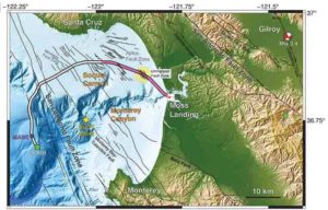
Researchers employed 20 kilometers (pink) of a 51-kilometer undersea fiber-optic cable, normally used to communicate with an off-shore science node (MARS, Monterey Accelerated Research System), as a seismic array to study the fault zones under Monterey Bay. During the four-day test, the scientists detected a magnitude 3.5 earthquake 45 kilometers away in Gilroy, and mapped previously uncharted fault zones (yellow circle). Credit: Nate Lindsey, UC Berkeley
Fiber-optic cables that constitute a global undersea telecommunications network could one day help scientists study offshore earthquakes and the geologic structures hidden deep beneath the ocean surface.
In a paper appearing this week in the journal Science, researchers from the University of California, Berkeley, Lawrence Berkeley National Laboratory (Berkeley Lab), Monterey Bay Aquarium Research Institute (MBARI) and Rice University describe an experiment that turned 20 kilometers of undersea fiber-optic cable into the equivalent of 10,000 seismic stations along the ocean floor. During their four-day experiment in Monterey Bay, they recorded a 3.5 magnitude quake and seismic scattering from underwater fault zones.
Their technique, which they had previously tested with fiber-optic cables on land, could provide much-needed data on quakes that occur under the sea, where few seismic stations exist, leaving 70% of Earth’s surface without earthquake detectors.
“There is a huge need for seafloor seismology. Any instrumentation you get out into the ocean, even if it is only for the first 50 kilometers from shore, will be very useful,” said Nate Lindsey, a UC Berkeley graduate student and lead author of the paper.
Lindsey and Jonathan Ajo-Franklin, a geophysics professor at Rice University in Houston and a visiting faculty scientist at Berkeley Lab, led the experiment with the assistance of Craig Dawe of MBARI, which owns the fiber-optic cable. The cable stretches 52 kilometers offshore to the first seismic station ever placed on the floor of the Pacific Ocean, put there 17 years ago by MBARI and Barbara Romanowicz, a UC Berkeley Professor of the Graduate School in the Department of Earth and Planetary Science. A permanent cable to the Monterey Accelerated Research System (MARS) node was laid in 2009, 20 kilometers of which were used in this test while off-line for yearly maintenance in March 2018.
“This is really a study on the frontier of seismology, the first time anyone has used offshore fiber-optic cables for looking at these types of oceanographic signals or for imaging fault structures,” said Ajo-Franklin. “One of the blank spots in the seismographic network worldwide is in the oceans.”
The ultimate goal of the researchers’ efforts, he said, is to use the dense fiber-optic networks around the world—probably more than 10 million kilometers in all, on both land and under the sea—as sensitive measures of Earth’s movement, allowing earthquake monitoring in regions that don’t have expensive ground stations like those that dot much of earthquake-prone California and the Pacific Coast.
“The existing seismic network tends to have high-precision instruments, but is relatively sparse, whereas this gives you access to a much denser array,” said Ajo-Franklin.
Photonic seismology
The technique the researchers use is Distributed Acoustic Sensing, which employs a photonic device that sends short pulses of laser light down the cable and detects the backscattering created by strain in the cable that is caused by stretching. With interferometry, they can measure the backscatter every 2 meters (6 feet), effectively turning a 20-kilometer cable into 10,000 individual motion sensors.
“These systems are sensitive to changes of nanometers to hundreds of picometers for every meter of length,” Ajo-Franklin said. “That is a one-part-in-a-billion change.”
Earlier this year, they reported the results of a six-month trial on land using 22 kilometers of cable near Sacramento emplaced by the Department of Energy as part of its 13,000-mile ESnet Dark Fiber Testbed. Dark fiber refers to optical cables laid underground, but unused or leased out for short-term use, in contrast to the actively used “lit” internet. The researchers were able to monitor seismic activity and environmental noise and obtain subsurface images at a higher resolution and larger scale than would have been possible with a traditional sensor network.
“The beauty of fiber-optic seismology is that you can use existing telecommunications cables without having to put out 10,000 seismometers,” Lindsey said. “You just walk out to the site and connect the instrument to the end of the fiber.”
During the underwater test, they were able to measure a broad range of frequencies of seismic waves from a magnitude 3.4 earthquake that occurred 45 kilometers inland near Gilroy, California, and map multiple known and previously unmapped submarine fault zones, part of the San Gregorio Fault system. They also were able to detect steady-state ocean waves—so-called ocean microseisms—as well as storm waves, all of which matched buoy and land seismic measurements.
“We have huge knowledge gaps about processes on the ocean floor and the structure of the oceanic crust because it is challenging to put instruments like seismometers at the bottom of the sea,” said Michael Manga, a UC Berkeley professor of earth and planetary science. “This research shows the promise of using existing fiber-optic cables as arrays of sensors to image in new ways. Here, they’ve identified previously hypothesized waves that had not been detected before.”
According to Lindsey, there’s rising interest among seismologists to record Earth’s ambient noise field caused by interactions between the ocean and the continental land: essentially, waves sloshing around near coastlines.
“By using these coastal fiber optic cables, we can basically watch the waves we are used to seeing from shore mapped onto the seafloor, and the way these ocean waves couple into the Earth to create seismic waves,” he said.
To make use of the world’s lit fiber-optic cables, Lindsey and Ajo-Franklin need to show that they can ping laser pulses through one channel without interfering with other channels in the fiber that carry independent data packets. They’re conducting experiments now with lit fibers, while also planning fiber-optic monitoring of seismic events in a geothermal area south of Southern California’s Salton Sea, in the Brawley seismic zone.
Reference:
N.J. Lindsey at University of California, Berkeley in Berkeley, CA el al., “Illuminating seafloor faults and ocean dynamics with dark fiber distributed acoustic sensing,” Science (2019). science.sciencemag.org/cgi/doi … 1126/science.aay5881
Russian and Italian scientists have recently come closer to understanding volcanic eruptions by studying Monte Nuovo near Naples as a basis. Lava, the molten rock that forms and then solidifies on the Earth’s surface, contains information that can not only reveal the causes of eruptions, but also unravel the mysteries of the planet’s past and future.
The study of Italian volcanoes has advanced thanks to the new physical methods of Professor Sultan Dabagov’s laboratory at MEPhI and INFN (National Institute of Nuclear Physics in Italy). The latest advances in physics were used in the research, which has allowed scientists to obtain the information “recorded” in the remains of an eruption.
“Our work is a detailed study of the active phase in the planet’s life, which manifests itself in the form of volcanic eruptions. Eruptions are complex phenomena, and finding the correlations between their many variables is a step toward understanding and prediction. We used powerful sources of X-ray radiation capable of penetrating deep into the studied samples without destroying them,” Sultan Dabagov, the research director, professor at the Institute of Nanotechnology in Electronics, Spintronics and Photonics at MEPhI, told Sputnik.
According to the scientist, in the first stage, they studied volcanic samples using multi-capillary optics based on X-rays. Then, to confirm the results, they examined the samples using more powerful synchrotron radiation. This made it possible to obtain X-rays and tomograms of the samples, recreate the internal features of various rocks and obtain high-resolution three-dimensional models.
The researchers believe that analyzing these models in comparison to samples of other eruptions will lead to conclusions about historically known eruptions and the eruptions of active and passive volcanoes.
“The data obtained using computed tomography and synchrotron radiation can be integrated into the general environment of feature-finding methods used in geology. We can better understand the impact of micro- and nanoporosity of the studied rocks on their permeability in order to answer many important questions on the formation and the future development of the planet,” Sultan Dabagov said.
The work of the Russian and Italian scientists is aimed at creating a tool that allows for detailed tomographic analysis in a lab using a low-power X-ray tube. This is possible with multi-capillary optics.
The new tool will allow for the continuous study of volcanic samples since it is smaller and cheaper than synchrotron sources (this will help equip almost any geological research center). According to experts, the use of multi-capillary optics with small-sized sources and radiation detectors can form the basis for creating compact portable devices for analyzing various rocks on the ground, without moving samples.
Reference:
A. Liedl et al. A 3D imaging textural characterization of pyroclastic products from the 1538 AD Monte Nuovo eruption (Campi Flegrei, Italy), Lithos (2019). DOI: 10.1016/j.lithos.2019.05.010
Spherules in the Barberton greenstone belt in the Kaapvaal craton, South Africa. Credit: Lowe et al., 2014.
When — and how — Earth’s surface evolved from a hot, primordial mush into a rocky planet continually resurfaced by plate tectonics remain some of the biggest unanswered questions in earth science research. Now a new study, published in Geology, suggests this earthly transition may in fact have been triggered by extra-terrestrial impacts.
“We tend to think of the Earth as an isolated system, where only internal processes matter,” says Craig O’Neill, director of Macquarie University’s Planetary Research Centre. “Increasingly, though, we’re seeing the effect of solar system dynamics on how the Earth behaves.”
Modelling simulations and comparisons with lunar impact studies have revealed that following Earth’s accretion about 4.6 billion years ago, Earth-shattering impacts continued to shape the planet for hundreds of millions of years. Although these events appear to have tapered off over time, spherule beds — distinctive layers of round particles condensed from rock vaporized during an extra-terrestrial impact — found in South Africa and Australia suggest the Earth experienced a period of intense bombardment about 3.2 billion years ago, roughly the same time the first indications of plate tectonics appear in the rock record.
This coincidence caused O’Neill and co-authors Simone Marchi, William Bottke, and Roger Fu to wonder whether these circumstances could be related. “Modelling studies of the earliest Earth suggest that very large impacts — more than 300 km in diameter — could generate a significant thermal anomaly in the mantle,” says O’Neill. This appears to have altered the mantle’s buoyancy enough to create upwellings that, according to O’Neill, “could directly drive tectonics.”
But the sparse evidence found to date from the Archaean — the period of time spanning 4.0 to 2.5 billion years ago — suggests that mostly smaller impacts less than 100 km in diameter occurred during this interval. To determine whether these more modest collisions were still large and frequent enough to initiate global tectonics, the researchers used existing techniques to expand the Middle Archaean impact record and then developed numerical simulations to model the thermal effects of these impacts on Earth’s mantle.
The results indicate that during the Middle Archaean, 100-kilometer-wide impacts (about 30 km wider than the much younger Chixculub crater) were capable of weakening Earth’s rigid, outermost layer. This, says O’Neill, could have acted as a trigger for tectonic processes, especially if Earth’s exterior was already “primed” for subduction.
“If the lithosphere were the same thickness everywhere, such impacts would have little effect,” states O’Neill. But during the Middle Archean, he says, the planet had cooled enough for the mantle to thicken in some spots and thin in others. The modelling showed that if an impact were to happen in an area where these differences existed, it would create a point of weakness in a system that already had a large contrast in buoyancy — and ultimately trigger modern tectonic processes.
“Our work shows there is a physical link between impact history and tectonic response at around the time when plate tectonics was suggested to have started,” says O’Neill. “Processes that are fairly marginal today — such as impacting, or, to a lesser extent, volcanism — actively drove tectonic systems on the early Earth,” he says. “By examining the implications of these processes, we can start exploring how the modern habitable Earth came to be.”
Reference:
C. O’Neill, S. Marchi, W. Bottke, R. Fu. The role of impacts on Archaean tectonics. Geology, 2019; DOI: 10.1130/G46533.1
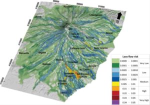
Oblique view of the risk map for lava flow inundation on the flanks of Mt. Etna for the next 50 years. Colors represent different levels of risk and indicate the probability of damage. The lava flow risk map constitutes a powerful instrument to promptly evaluate the real cost of living in areas near Mt. Etna and provide a tool both for the management of the eruptive emergencies and the long-term planning of the territory. In addition, the risk assessment approach developed by researchers of the TecnoLab at the INGV in Catania allows a fast update of the risk map including new data as soon as they are available. Credit: Del Negro and colleagues
On Mt. Etna volcano, inhabited areas have been inundated repeatedly by lava flows in historical times. The increasing exposure of a larger population, which has almost tripled in the area around Mt. Etna during the last 150 years, has resulted from on a poor assessment of the volcanic hazard and risk, allowing inappropriate land use in vulnerable areas. Thus, the researchers of the Laboratory of Technologies for Volcanology (TecnoLab) at the INGV in Catania assessed and mapped hazard, exposure, and risk for providing a basic broad overview of the potential effusive eruption impacts on the flanks of Mt. Etna.
Despite our knowledge of volcanic hazards and our capability to monitor volcanic activity, the possibility that effusive eruptions of Etna volcano could harm people, properties and services is greater today than ever before. A 2013 analysis of lava flow hazards and their distribution around the Etna volcano showed them to be far more dangerous than previously expected. There is no compelling evidence to think that rates and magnitudes of volcanism are changing, but, as a consequence of rising population densities, increasingly sophisticated facilities, and expanding complex social and economic infrastructure, all communities around Mt. Etna are becoming more vulnerable to experiencing heavy consequences from volcanic hazard activity.
The researchers of the TecnoLab assessed the lava flow risk on the flanks of Mt. Etna by using a GIS-based approach that combines simply the hazard with the exposure of elements at stake (the vulnerability was not considered). The hazard, showing the long-term probability related to lava flow inundation, was obtained by combining three different kinds of information: the spatiotemporal probability of the future opening of new flank eruptive vents, the event probability associated with classes of expected eruptions, and the overlapping of lava flow paths simulated by the MAGFLOW model. Data including all exposed elements were gathered from institutional web portals and high-resolution satellite imagery, and organized in four thematic layers: population, buildings, service networks, and land use. The total exposure is given by a weighted linear combination of the four thematic layers, where weights are calculated using the Analytic Hierarchy Process (AHP).
The resulting risk map shows the likely damage caused by a lava flow eruption, allowing rapid visualization of the areas in which there would be the greatest losses if a flank eruption occurred on Mt. Etna. The highest hazard levels were obtained within the uninhabited Valle del Bove and along the upper portions of the South and North-East Rifts. Instead, higher exposure levels were found near the eastern coast where the population is highly concentrated and, as a consequence, there are wider urban areas and critical infrastructures. By combining the location of the main population centers on Etna with those where the hazard is high, we identified the south-eastern flank as the sector with the highest overall level of risk due to effusive eruptions from vents located on the volcano flanks.
Reference:
Ciro Del Negro et al. Living at the edge of an active volcano: Risk from lava flows on Mt. Etna, GSA Bulletin (2019). DOI: 10.1130/B35290.1
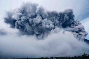
Anak Krakatoa eruption. Credit: Dr Mohammad Heidarzadeh
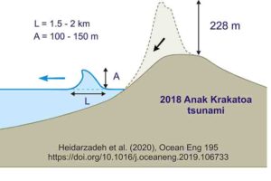
The deadly volcanic eruption of Anak Krakatoa in 2018 unleashed a wave at least 100m high that could have caused widespread devastation had it been travelling in another direction, new research shows.
Over 400 people lost their lives in December 2018 when Anak Krakatoa erupted and partially collapsed into the sea, sending a wave westward towards the Indonesian island of Sumatra that was between 5 and 13 metres high when it made landfall less than an hour later.
However, new analysis from researchers at Brunel University London and the University of Tokyo has shown that the disaster wreaked could have been significantly worse had the wave—which started between 100m and 150m high—been travelling towards closer shores.
“When volcanic materials fall into the sea they cause displacement of the water surface,” said Dr. Mohammad Heidarzadeh, an assistant professor of civil engineering at Brunel, who led the study. “Similar to throwing a stone into a bathtub—it causes waves and displaces the water.
“In the case of Anak Krakatoa, the height of the water displacement caused by the volcano materials was over 100m.”
Although the height of the wave quickly shrunk, thanks mainly to the joint effects of gravity pulling the mass of water downward and the friction generated between the tsunami wave and the seafloor, it was still over 80m high when it hit an uninhabited island just a few kilometres away.
“Fortunately, nobody was living on that island,” said Dr. Heidarzadeh. “However, if there was a coastal community close to the volcano—say, within 5km—the tsunami height would have been between 50m and 70m when it hit the coast.”
For context, Dr. Heidarzadeh gives the example of the 1883 eruption of Krakatoa, which generated a tsunami that struck land at a maximum height of 42m, causing at least 36,000 deaths at a time when the coastal areas were less populated.
The new research is important for coastal communities living near volcanos all over the world, said Dr. Heidarzadeh, as it’s the first to show that such a huge wave could be generated by the December 2018 Anak Krakatoa volcanic eruption.
The new analysis, published in the journal Ocean Engineering, used sea-level data from five locations near Anak Krakatoa to validate computer models which simulated the tsunami’s movement from the collapse of the volcano to landfall.
“The measurements were done by wave gauges operated by the government of Indonesia,” Dr. Heidarzadeh said.
“We used that real data to make sure that our simulations are consistent with reality—it’s extremely important to validate computer simulations with real-world data.”
Indonesia, one of the most earthquake and tsunami prone areas of the world, was struck by two deadly waves in 2018—one unleashed by Anak Krakatoa, and one by a landslide off the coast of Sulawesi, which killed over 2000 people.
Dr. Heidarzadeh will now be working with the Indonesian Institute of Sciences (LIPI) and Agency for the Assessment & Application of Technology (BPPT) to map the country’s eastern seafloor and develop a new tsunami resilience plan – a project funded by £500,000 from The Royal Society.
Reference:
Mohammad Heidarzadeh et al. Numerical modeling of the subaerial landslide source of the 22 December 2018 Anak Krakatoa volcanic tsunami, Indonesia, Ocean Engineering (2019). DOI: 10.1016/j.oceaneng.2019.106733
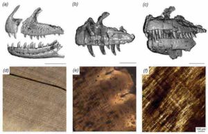
CT scan-generated models of the jaws of Majungasaurus (left), Ceratosaurus (center) and Allosaurus (right), with microscopic views of the interior of their teeth below each model. Stripes running from upper left to lower right in each microscopic image are daily deposited incremental lines, which allow the amount of time it took for a tooth to grow to be reconstructed. Credit: PLOS ONE
A meat-eating dinosaur species (Majungasaurus) that lived in Madagascar some 70 million years ago replaced all its teeth every couple of months or so, as reported in a new study published today in the open-access journal PLOS ONE, surprising even the researchers.
In fact, Majungasaurus grew new teeth roughly two to thirteen times faster than those of other carnivorous dinosaurs, says paper lead-author Michael D. D’Emic, an assistant professor of biology at Adelphi University. Majungasaurus would form a new tooth in each socket approximately every two months.
“This meant they were wearing down on their teeth quickly, possibly because they were gnawing on bones,” D’Emic said. “There is independent evidence for this in the form of scratches and gouges that match the spacing and size of their teeth on a variety of bones—bones from animals that would have been their prey.” Importantly, the study also examined two other species of predatory dinosaur (Allosaurus and Ceratosaurus), providing an opportunity to consider tooth growth patterns at a broader scale.
Some animals today, too, will gnaw on bones, including rodents, D’Emic said. It’s a way for them to ingest certain nutrients. It also requires exceptionally strong teeth—but Majungasaurus did not have those.
“That’s our working hypothesis for why they had such elevated rates of replacement,” D’Emic said. The rapid-fire tooth growth puts Majungasaurus in same league with sharks and big, herbivorous dinosaurs, he adds.
In collaboration with Patrick O’Connor, professor of anatomy at Ohio University, D’Emic used a collection of isolated fossil teeth to examine microscopic growth lines in the teeth. These growth lines are similar to tree rings, but instead of being deposited once a year, they are deposited daily. At the same, the team used computerized tomography (CT) on intact jaws to visualize unerupted teeth growing deep inside the bones. This allowed them to estimate tooth-replacement rates in a large number of individual jaws so they could cross-check their results.
The time-consuming process would not have been possible without the involvement of students at both OHIO and Adelphi. Graduate students Thomas Pascucci (Adelphi University) and Eric Lund (Ohio University) played important roles as part of the research team, serving to conduct both microscopic and digital computed tomography analyses at the heart of the study.
“As an interdisciplinary Ph.D. student, being able to work on impactful, multi-institutional research utilizing novel approaches has been really influential and highlights the power of interdisciplinary approaches to answering tough scientific questions,” Lund said.
“The ability to interface with colleagues across the state, country, or planet, particularly when we can include students in different parts of the research process, is a game changer when we consider collaborative research in the 21st Century,” O’Connor stated. “This project addresses yet another aspect of the biology of Majungasaurus, and predatory dinosaurs more generally,” he added, “heralding the next phase of research based on recent field discoveries.”
Reconstruction of Jeholbaatar kielanae. Credit: XU Yong
Researchers from the Institute of Vertebrate Paleontology and Paleoanthropology (IVPP) of the Chinese Academy of Sciences and the American Museum of Natural History (AMNH) have reported a new species of multituberculate—a type of extinct Mesozoic rodent—with well-preserved middle ear bones from the Cretaceous Jehol Biota of China. The findings were published in Nature on November 27.
The new mammal, Jeholbaatar kielanae, has a middle ear that is distinct from those of its relatives. Wang Yuanqing and Wang Haibing from IVPP, along with Meng Jin from AMNH, proposed that the evolution of its auditory apparatus might have been driven by specialization for feeding.
Fossil evidence shows that postdentary bones were either embedded in the postdentary trough on the medial side of the dentary or connected to the dentary via an ossified Meckel’s cartilage in early mammals, prior to their migration into the cranium as seen in extant mammals.
Detachment of the mammalian middle ear bones from the dentary occurred independently at least three times. But how and why this process took place in different clades of mammals remains unclear.
The Jeholbaatar kielanae specimen was discovered in the Jiufotang Formation in China’s Liaoning Province (Jehol Biota). It displays the first well-preserved middle-ear bones in multituberculates, providing solid evidence of the morphology and articulation of these bony elements, which are fully detached from the dentary.
It reveals a unique configuration with more complete components than those previously reported in multituberculates. The new fossil reveals a transitional stage in the evolution of the surangular—a “reptilian” jawbone.
In light of current evidence, scientists argue that the primary (malleus-incus) and secondary (squamosal-dentary) jaw joints co-evolved in allotherians, allowing a distinct palinal (anteroposterior) jaw movement while chewing.
Detachment of the auditory apparatus of the middle ear would have gained higher selective pressure in order to increase feeding efficiency, suggesting that evolution of the middle ear was probably triggered by functional constraints on the feeding apparatus in allotherians.
Reference:
Cretaceous fossil reveals a new pattern in mammalian middle ear evolution, Nature (2019). DOI: 10.1038/s41586-019-1792-0
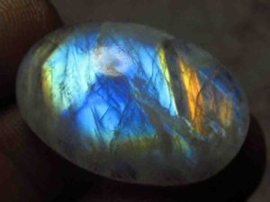
Moonstone is a sodium potassium aluminium silicate ((Na,K)AlSi3O8) of the feldspar group that displays a pearly and opalescent schiller. An alternative name is hecatolite
The name derives from a visual effect, sheen or schiller (adularescence), caused by light diffraction within a microstructure consisting of normal exode layers (lamellae) of specific alkali feldspars (orthoclase and sodium-rich plagioclase).
Moonstone is an opalescent orthoclase type. Traditionally thought of as a stone of good luck and connected to a romantic desire, it was often given as a gift to lovers. Moonstone can be translucent with a strong blue hue on the surface, or it can be milky with the appearance of inner light.
The ancient Romans had theorized that Moonstone, with its unfathomable glow, had been created by frozen moonlight. This beautiful gem variety shines with cool lunar light, but it is a mineral feldspar, very terrestrial in nature. The shimmer, called schiller or adularescence, is caused by the intergrowth of two different types of feldspar with different refractive indexes.
Moonstones come in a variety of colors. The body color can range from colorless to gray, brown, yellow, green, or pink. The clarity ranges from transparent to translucent. The best moonstone has a blue sheen, perfect clarity, and a colorless body color.
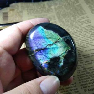
Sometimes the moonstone has an eye as well as a glare. The similar feldspar form is known as Moonstone Rainbow. A variety of feldspar labradorite has a range of rainbow colours, from red and orange, to white, purple and blue. Sometimes a gem will reveal all of these colors.
Fine moonstone is quite rare and becoming rarer. It is mined in Sri Lanka and Southern India. The rainbow variety can be found in India and Madagascar.
Moonstones are usually cut in a smooth, oval cabochon shape to maximize the effect. Sometimes it’s carved to display a man-in – the-moon head.
Moonstone has a 6 to 6.5 hardness. It should not be kept in contact with your other gemstones to avoid scratching. Wash with a mild soap dish: use a toothbrush to clean behind a stone where dust can be gathered.
Types and Colours of Moonstone
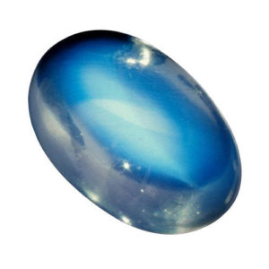
Blue Moonstone
Blue Moonstone
The blue moonston with its floating blue color on the surface is transparent and crystal clear. The most desirable rocks are of the strongest blue colour. The largest and best stones usually come from Myanmar (Burma), but the discovery of good stones became much more difficult and the price rose.
Blue moonstone is sometimes faceted, however much care needs to be taken when working with it, as the material can be brittle and break under pressure.
Rainbow Moonstone
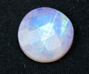
The Rainbow Moonstone emerges from the empty orthoclastic inclusions and textures and has a milky patchy look. The reflection from the layers and inclusions generates a rainbow effect when the stone attracts light. This is a very common color play and is commonly used in silver jewelry.
Rainbow Moonstone
The scientific name for moonstone with rainbows is labradorite, and although the name is distinct from genuine orthoclase moonstone.
Moonstone has a transparent, white color similar to “moonshine” which, when rolled, rolls or floats over the stone, which is why the term is called “moonstone.” A rainbow moonstone is typically a creamy translucent white stone with occasional (particularly blue) iridescent or painted flashes that varies from opaque to semitranslucent.
Moonstone Rainbow is best seen for playing color in the natural light. In the jewels of ancient civilizations Moonstone was used. The Romans thought that the moon was born from solidified moon rays. The Romans and Greeks combined lunar gods with moonstones. Moonstone became famous with the development of jewellery artists and goldsmiths during the Art Nouveau period in the early 20th century.
The moonstone of Rainbow is present in various parts of the world, including China, India, Australia, Malagasy, Sri Lanka and Russia. Because the feldspar mineral comprises 60% of the Earth’s crust, it is commonly found in small parts and smaller parts are much rarer.
Green Moonstone
Green Moonstone
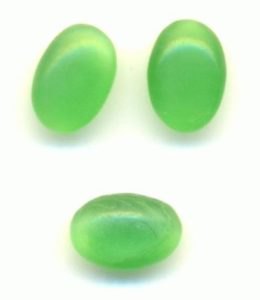
Green moon is not as well recognized as a rainbow or a blue moon as the color game, but it’s still a lovely stone. This usually appears slightly white or transparent with a pale green-yellow colour. If you look down on the pier, like a full moon, you’re going to see a glow from inside. This optical effect is usually filtered out with a tall dome, and often a star of light on the top of the dome can be seen.
Pink Moonstone
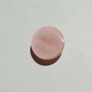
Pink Moonstone
The term pink encompasses color, varying from honey to beige to peach. The stone has a white shine and often is seen with the appearance of a cat’s eye or a star. This type of rock is commonly used in painted bead columns.
Orthoclase
The orthoclase feldspar is an essential mineral of the tectosilicate, or orthoclase orthodontic (endmember formulation KAlSi3O8). It’s a “straight fracture,” since its two cleavages are at right angles to each other. The name is of Ancient Greek. It’s a potassium feldspar type, also referred to as K-feldspar. The diamond (composed mainly by orthoclase) is called the moonstone.
Orthoclase is an expensive, colorless, pale yellow and transparent stone which has a white or shiny blue tone. The colourless variety, as seen on Mount Adular in Switzerland, is called adularia. Due to its fragile nature, orthoclase is usually seen as a step cut and is therefore not widely used or produced.
Amazonite
Amazonite is a mineral that is beautiful and opaque. It is either a blue-green or a blue and white streaked hue because of the presence of mercury. Even with the solid color content, the color pattern is typically erratic. Amazonite can come in various colors, including orange, purple, red and gray but it is the most popular and widely used blue green paint.
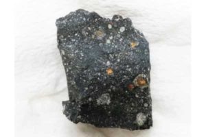
This is a Murchison meteorite. Sugars are found from this meteorite in this study.. Credit: Yoshihiro Furukawa
Researchers from Tohoku University, Hokkaido University, JAMSTEC, and NASA Goddard Space Flight Center investigated meteorites and found ribose and other sugars. These sugars possessed distinct carbon-isotope compositions, differing from terrestrial biological sugars, indicating their extraterrestrial origin. The results suggest that the sugars formed in the early solar system and made their way to earth via meteorites.
The team analyzed three meteorites with their original protocol and found sugars in two meteorites. “Analysis of sugars in meteorites is so difficult. Over the past several years, we have investigated the techniques of sugar analysis in such samples and constructed our original method” says lead author, Yoshihiro Furukawa of Tohoku University.
Amino acids and nucleobases, other vitally important compounds in the building block of life, have been found in meteorites previously. Scientists have known of the existence of sugars in meteorites. However, research to date has largely revealed sugar-related compounds (sugar acids and sugar alcohols) and the simplest sugar (dihydroxy acetone), compounds not considered essential for life.
Formation of bio-essential sugars, including ribose, on the prebiotic Earth, is considered to have been possible. However, there is no geological evidence of their formation. Furthermore, it is not clear which and how much sugar(s) formed on the prebiotic Earth.
With the current research evidencing the delivery of bio-essential sugars, it is plausible that extraterrestrial sugar contributed to the formation of primordial RNA on the prebiotic Earth. This, in turn, has the possibility of being a factor in the origin of life.
“The next step is to investigate the chirality of the sugars in more meteorites and to investigate how much sugars were provided from space and how the extraterrestrial sugar influenced life’s homochirality” says the team. NASA Jonson Space Center has provided the team other meteorites and the team will analyze them to see which meteorites contain the sugars and how theses sugars formed.
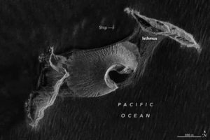
An October 7th, 2019 image of Hunga Tonga-Hunga Ha‘apai from NASA Earth Observatory. Credit: Joshua Stevens, using RADARSAT-2 data courtesy of James Garvin/NASA GSFC
A surtseyan eruption is a volcanic eruption in shallow water. It’s named after the island Surtsey, off the coast of Iceland. In 2015, a surtseyan eruption in the Tongan Archipelago created the island Hunga Tonga-Hunga Ha’apai. Despite the odds, that island is still there almost five years later.
Fortunately, scientists have a wealth of resources at their disposal to study this whole phenomenon. These types of eruptions are difficult to study, since they occur underwater, and often in remote locations. They also tend to erode away quickly. But Earth-observing satellites are changing that, and Hunga Tonga-Hunga Ha’apai is the first of its kind to be studied intensively, especially during its formation.
Jim Garvin and Dan Slayback are two NASA scientists who have studied the volcanic island. They’ve relied on radar imaging satellites to do so, using synthetic aperture radar (SAR). SAR can see through clouds and can see at night, providing high-resolution images of the island. In 2018, Garvin, Slayback, and other scientists published a paper on their observations in the AGU journal Geophysical Letters. The paper is titled “Monitoring and Modeling the Rapid Evolution of Earth’s Newest Volcanic Island: Hunga Tonga Hunga Ha’apai (Tonga) Using High Spatial Resolution Satellite Observations.”
Before the eruption, there were two small islands nearby. They were in a relatively isolated location, about 30 kilometers (19 miles) from the Tongan island of Fonuafo’ou. On December 19, 2014, fishermen spotted a plume of white steam rising from under the water. Satellite images from December 29th show the plume. Eventually, an ash cloud rose 3 kilometers into the sky on January 9th, 2015. By January 11th, the plume reached 9 kilometers (30,000 feet) high.
By January 26, Tongan officials declared the eruption over. By that time, the island was 1 to 2 kilometers (0.62 to 1.24 miles) wide, 2 kilometers (1.2 miles) long, and 120 meters (390 feet) high.
During 2015, the island stabilized somewhat, thanks to redistribution of volcanic material and “hydrothermal alteration” of the same. The island had a crater lake in the middle, which was eventually eroded away. Then a sandbar formed, sealing it off again, and protecting it from ocean waves. Eventually, ash and sediment widened the isthmus connecting it to Hunga Tonga to the northeast.
The team studying this volcanic island has developed two scenarios for its future.
The first sees accelerated erosion due to ocean waves, and in six or seven years, only the land bridge connecting the two island would remain. What’s called the “tuff cone” would be eroded. The second scenario sees slower erosion, with the tuff cone intact for up to 30 years.
The volcanic island changed the most in its first six months. At that time, Slayback and Garvin thought that the island might disappear quickly. When the barrier protecting the crater lake and the tuff cone was washed away, they thought the island’s demise was near. But the sandbar reappeared.
“Those cliffs of volcanic ash are pretty unstable,” said remote sensing specialist and co-author Dan Slayback of NASA Goddard in a press release.
This new volcanic island and its neighbors are situated above the north rim of a caldera of a much larger underwater volcano. That whole complex rises 1400 meters (4,593 feet) above the ocean floor, and the larger caldera is about 5 kilometers (3 miles) across.
In 2017, NASA scientist Jim Garvin said, “Volcanic islands are some of the simplest landforms to make. Our interest is to calculate how much the three-dimensional landscape changes over time, particularly its volume, which has only been measured a few times at other such islands. It is the first step to understanding erosion rates and processes and deciphering why the island has persisted longer than most people expected.”
Dan Slayback visited the island in October 2019, and wrote in a blog post: “We made many useful observations, collected some good data, and gained a more practical human-scale understanding of the topography of the place (such as that the adjacent pre-existing islands and their rocky shorelines are almost fortress-like in their inaccessibility). We also saw things not accessible from space, such as the hundreds of nesting sooty terns, and details of the emergent vegetation.”
A Martian Connection?
Garvin and Slayback think that their study of this volcano is not only useful for understanding our own planet; they think it might shed light on processes on Mars.
“Using the Earth to understand Mars is, of course, something we do,” Garvin said, noting the similarities in erosion on the island and scars left by ancient eruptions through shallow seas on Mars. “Mars may not have a place exactly like this, but still, it bespeaks the planet’s history of persistent water.”
Mars is not without volcanoes. In fact, it’s home to the largest volcano in the solar system, now dormant. Olympus Mons rises almost 22 kilometers (13.6 miles or 72,000 feet) above the surface of Mars. It’s the granddaddy of volcanoes. But NASA’s Mars Reconnaissance Orbiter (MRO) has found fields of smaller volcanoes. These volcanoes may once have erupted into the Martian oceans, deep in that planet’s geological past. Those surviving landscapes could tell us something about how those ancient volcanoes responded to the active Mars environment.
Reference:
J. B. Garvin et al. Monitoring and Modeling the Rapid Evolution of Earth’s Newest Volcanic Island: Hunga Tonga Hunga Ha’apai (Tonga) Using High Spatial Resolution Satellite Observations, Geophysical Research Letters (2018). DOI: 10.1002/2017GL076621
Note: The above post is reprinted from materials provided by Universe Today.
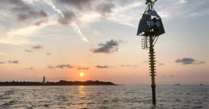
The shallow water buoy can detect small movements and changes in the Earth’s seafloor that are often a precursor to deadly natural hazards, like earthquakes, volcanoes and tsunamis. Credit: University of South Florida
University of South Florida geoscientists have successfully developed and tested a new high-tech shallow water buoy that can detect the small movements and changes in the Earth’s seafloor that are often a precursor to deadly natural hazards, like earthquakes, volcanoes and tsunamis.
The buoy, created with the assistance of an $822,000 grant from the National Science Foundation’s Ocean Technology and Interdisciplinary Coordination program, was installed off Egmont Key in the Gulf of Mexico last year and has been producing data on the three-dimensional motion of the sea floor. Ultimately the system will be able to detect small changes in the stress and strain the Earth’s crust, said USF School of Geosciences Distinguished Professor Tim Dixon.
The patent-pending seafloor geodesy system is an anchored spar buoy topped by high precision Global Positioning System (GPS). The buoy’ orientation is measured using a digital compass that provides heading, pitch, and roll information — helping to capture the crucial side-to-side motion of the Earth that can be diagnostic of major tsunami-producing earthquakes, Dixon said. He was joined in leading the project by USF Geoscience Phd student Surui Xie, Associate Professor Rocco Malservisi USF College of Marine Science’s Center for Ocean Technology research faculty member Chad Lembke, and a number of USF ocean technology personnel.
Their findings were recently published in the Journal of Geophysical Research-Solid Earth.
While there are several techniques for seafloor monitoring currently available, that technology typically works best in the deeper ocean where there is less noise interference. Shallow coastal waters (less than a few hundred meters depth) are a more challenging environment but also an important one for many applications, including certain types of devastating earthquakes, the researchers said. Offshore strain accumulation and release processes are critical for understanding megathrust earthquakes and tsunamis, they noted.
The experimental buoy rests on the sea bottom using a heavy concrete ballast and has been able to withstand several storms, including Hurricane Michael’s march up the Gulf of Mexico. The system is capable of detecting movements as small as one to two centimeters, said Dixon, an expert on natural hazards and author of the book Curbing Catastrophe.
“The technology has several potential applications in the offshore oil and gas industry and volcano monitoring in some places, but the big one is for improved forecasting of earthquakes and tsunamis in subduction zones,” Dixon said. “The giant earthquakes and tsunamis in Sumatra in 2004 and in Japan in 2011 are examples of the kind of events we’d like to better understand and forecast in the future.”
Dixon said the system is designed for subduction zone applications in the Pacific Ocean’s “Ring of Fire” where offshore strain accumulation and release processes are currently poorly monitored. One example where the group hopes to deploy the new system is the shallow coastal waters of earthquake prone Central America.
The Egmont Key test location sits in just 23 meters depth. While Florida is not prone to earthquakes, the waters off Egmont Key proved an excellent test location for the system. It experiences strong tidal currents that tested the buoy’s stability and orientation correction system. The next step in the testing is to deploy a similar system in deeper water of the Gulf of Mexico off Florida’s west coast.
Reference:
Surui Xie, Jason Law, Randy Russell, Timothy H. Dixon, Chad Lembke, Rocco Malservisi, Mel Rodgers, Giovanni Iannaccone, Sergio Guardato, David F. Naar, Daniele Calore, Nicola Fraticelli, Jennifer Brizzolara, John W. Gray, Matt Hommeyer, Jing Chen. Seafloor Geodesy in Shallow Water With GPS on an Anchored Spar Buoy. Journal of Geophysical Research: Solid Earth, 2019; DOI: 10.1029/2019JB018242
Opal is a hydrated amorphous form of silica (SiO2·nH2O); its water content can range from 3 to 21 per cent by weight, but is usually between 6 and 10 per cent. Because of its amorphous nature, it is classified as mineraloid, unlike the crystalline forms of silica, which are classified as minerals.
It is deposited at a relatively low temperature and can occur in cracks of almost any kind of rock, most commonly found with limonite, sandstone, rhyolite, marl and basalt. Opal is Australia’s national gemstone.
Moonstone
Moonstone is a sodium potassium aluminum silicate ((Na, K)AlSi3O8) of the feldspar group with a pearly and opalescent schiller.
The most common moonstone is the orthoclase feldspar mineral adularia, named for the early mining site near Mt. Adular in Switzerland, now the town of St. Gotthard. Strong solution of plagioclase feldspar oligoclase + /-Potassium feldspar orthoclase also contains lunar stone samples.
Physical Properties
Opal is hardened by silica. Measures 7 on the Mohs hardness scale, with 10 being the hardest. Opal is available in a variety of colours, including white, red, pink and blue.
Moonstone is one of the most valuable forms of feldspar. Measure 6 on the Mohs scale. Moonstone ranges in color from silver gray to peach and has a white or blue sheen.
Occurrence
Opal occurs in a significant quantity and variety in central Mexico, where the Querétaro state mining and production center is located. In this area, the opal deposits are mainly located in the mountain ranges of three municipalities: Colón, Tequisquiapan and Ezequiel Montes.
Spencer, Idaho, is another source of white opal base or creamy opal in the United States. A high percentage of opal contained exists in thin layers.
Other large deposits of precious opal can be found worldwide in the Czech Republic, Canada, Slovakia, Hungary, Turkey, Indonesia, Brazil (in Pedro II, Piauí), Honduras (more specifically in Erandique), Guatemala and Nicaragua.
Moonstone is the Florida State Gemstone; it was designated as such in 1970 to commemorate the Moon landings, which took off from Kennedy Space Center. Despite it being the Florida State Gemstone, it does not naturally occur in the state.
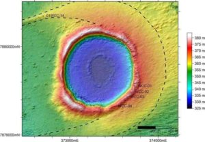
An orthophoto of Wolfe Creek Crater. An orthophoto is an aerial photograph that has been geometrically corrected so that the scale is uniform and the photo has the same lack of distortion as a map. Credit: University of Wollongong
A study by an international research team led by Professor Tim Barrows from the University of Wollongong has thrown new light on how frequently large meteorites strike the Earth.
The research focused on Wolfe Creek Crater, one of the largest meteorite impact craters in Australia and the second largest on Earth from which meteorite fragments have been recovered (the largest is Meteor Crater in Arizona in the United States).
Horror film buffs might recognise Wolfe Creek Crater from the 2005 film Wolf Creek.
Located in a remote part of Western Australia, on the edge of the Great Sandy Desert and about 145 kilometres from Halls Creek via the Tanami Road, Wolfe Creek Crater was formed by a meteorite estimated to be about 15 metres in diameter and weighing around 14,000 tonnes.
The meteorite was probably travelling at 17 kilometres per second and struck with the force of 0.54 megatons of TNT.
Just when that impact occurred, however, had not been well understood.
The new study, published in the journal Meteoritics & Planetary Science, found that the impact most likely occurred around 120,000 years ago—much more recently than the previous estimate of 300,000 years ago.
Debris from outer space constantly bombards the Earth, but only the biggest objects survive the journey through the atmosphere to hit the planet’s surface and leave a crater. Having an accurate age for the Wolfe Creek Crater impact enabled the researchers to calculate how frequently such impacts occur.
Including Wolfe Creek Crater, there are seven sets of impact craters in Australia dating to within the past 120,000 years, said Professor Barrows, a Future Fellow in UOW’s School of Earth, Atmospheric and Life Sciences.
“Although the rate is only one large meteor hitting Australia every 17,000 years, it isn’t that simple,” he said.
“The craters are only found in the arid parts of Australia. Elsewhere, craters are destroyed by geomorphic activity like river migration or slope processes in the mountains. Since Australia has an excellent preservation record with dated craters within the arid zone, we can extrapolate a rate for the whole Earth.
“Taking into account that arid Australia is only about one percent of the surface, the rate increases to one every 180 years or so.
“This is a minimum estimate because some smaller impacts were probably covered by sand during the ice age. The number of large objects is probably 20 times this number because stony meteorites are far more common but not as many survive the fiery journey through the atmosphere or effectively make craters.
“Our results give us a better idea of how frequent these events are.”
Professor Barrows and his colleagues used two techniques to date the crater: exposure dating (which estimates the length of time a rock has been exposed at the Earth’s surface to cosmic radiation) and optically stimulated luminescence (which measures how long ago sediment was last exposed to sunlight).
The researchers also created a new 3-D topographical model of the crater using aerial photographs taken by Ted Brattstrom, a Hawaiian high school teacher who flew over the crater in 2007 taking photos of it from a number of different directions. They used this to calculate the crater’s dimensions.
“We calculate that the maximum width of the crater is 946 metres in a NE-SW direction, reflecting the direction of the impact. The average diameter is 892 metres. We predict a depth of 178 metres and that it is filled by about 120 metres of sediment, mostly sand blown in from the desert,” Professor Barrows said.
Using the same geochronological dating techniques, the researchers were also able to recalculate the age of the Meteor Crater in Arizona. They found it is likely to be 61,000 years old, more than 10,000 years older than previously thought.
Reference:
Timothy T. Barrows et al. The age of Wolfe Creek meteorite crater ( Kandimalal ), Western Australia, Meteoritics & Planetary Science (2019). DOI: 10.1111/maps.13378
Reconstructed paleo-elevation in southwestern North America at the Late Eocene (36 million years ago). Credit: Bahadori and Holt
By using the latest computer numerical modeling technologies, combined with geologic compilations and seismic data, researchers in the Department of Geosciences at Stony Brook University have developed a complete geodynamic model that explains the forces behind the remarkable collapse of what were lofty mountains some 30 million years ago in what is now part of the American West.
The research, published in Nature Communications, includes visuals that reveal how the mountains were probably higher than the Rockies are today and how a complex system of faults chopped the region up, allowing mountains to expand bountifully and form the Basin and Range province and the now dangerous San Andreas fault system in California.
The article is authored by graduate student Ali Bahadori and William E. Holt, Ph.D., and the study was funded by the National Science Foundation.
Holt, who is the project leader, says that the results will be combined with climate and erosion models of the vast region to better explain this geologic evolution over millions of years and its impact on the fauna and flora found in the fossil record.
Reference:
Alireza Bahadori et al. Geodynamic evolution of southwestern North America since the Late Eocene, Nature Communications (2019). DOI: 10.1038/s41467-019-12950-8