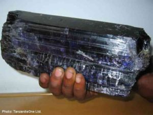
Bastnaesite (the reddish parts) in Carbonatite. Bastnaesite is an important ore for rare earth elements, one of the mineral commodities identified as most at-risk of supply disruption by the USGS in a new methodology. Credit: Scott Horvath, USGS
Policymakers and the U.S. manufacturing sector now have a powerful tool to help them identify which mineral commodities they rely on that are most at risk to supply disruptions, thanks to a new methodology by the U.S. Geological Survey and its partners.
“This methodology is an important part of how we’re meeting our goals in the President Trump’s Strategy to ensure a reliable supply of critical minerals,” said USGS director Jim Reilly. “It provides information supporting American manufacturers’ planning and sound supply-chain management decisions.”
The methodology evaluated the global supply of and U.S. demand for 52 mineral commodities for the years 2007 to 2016. It identified 23 mineral commodities, including some rare earth elements, cobalt, niobium and tungsten, as posing the greatest supply risk for the U.S. manufacturing sector. These commodities are vital for mobile devices, renewable energy, aerospace and defense applications, among others.
“Manufacturers of new and emerging technologies depend on mineral commodities that are currently sourced largely from other countries,” said USGS scientist Nedal Nassar, lead author of the methodology. “It’s important to understand which commodities pose the greatest risks for which industries within the manufacturing sector.”
The supply risk of mineral commodities to U.S. manufacturers is greatest under the following three circumstances: U.S. manufacturers rely primarily on foreign countries for the commodities, the countries in question might be unable or unwilling to continue to supply U.S. manufacturers with the minerals; and U.S. manufacturers are less able to handle a price shock or from a disruption in supply.
“Supply chains can be interrupted for any number of reasons,” said Nassar. “International trade tensions and conflict are well-known reasons, but there are many other possibilities. Disease outbreaks, natural disasters, and even domestic civil strife can affect a country’s mineral industry and its ability to export mineral commodities to the U.S.”
Risk is not set in stone; it changes based on global market conditions that are specific to each individual mineral commodity and to the industries that use them. However, the analysis indicates that risk typically does not change drastically over short periods, but instead remains relatively constant or changes steadily.
“One thing that struck us as we were evaluating the results was how consistent the mineral commodities with the highest risk of supply disruption have been over the past decade,” said Nassar. “This is important for policymakers and industries whose plans extend beyond year-to-year changes.”
For instance, between 2007 and 2016, the risk for rare earth elements peaked in 2011 and 2012 when China halted exports during a dispute with Japan. However, the supply of rare earth elements consistently remained among the highest risk commodities throughout the entire study period.
In 2019, the U.S. Department of Commerce, in coordination with the Department of the Interior and other federal agencies, published the interagency report entitled “A Federal Strategy to Ensure a Reliable Supply of Critical Minerals,” in response to President Trump’s Executive Order 13817. Among other things, the strategy commits the U.S. Department of the Interior to improve the geophysical, geologic, and topographic mapping of the U.S.; make the resulting data and metadata electronically accessible; support private mineral exploration of critical minerals; make recommendations to streamline permitting and review processes enhancing access to critical mineral resources.
The methodology is entitled “Evaluating the Mineral Commodity Supply Risk of the U.S. Manufacturing Sector,” and is published in Science Advances.
Reference:
Evaluating the mineral commodity supply risk of the U.S. manufacturing sector, Science Advances 21 Feb 2020: Vol. 6, no. 8, eaay8647, DOI: 10.1126/sciadv.aay8647
The rising Earth from the perspective of the moon. Credit: NASA Goddard
Sometimes, you need to leave home to understand it. For Stanford planetary geologist Mathieu Lapôtre, “home” encompasses the entire Earth.
“We don’t only look at other planets to know what’s out there. It’s also a way for us to learn things about the planet that’s under our own feet,” said Lapôtre, an assistant professor of geological sciences in the School of Earth, Energy, & Environmental Sciences (Stanford Earth).
Scientists since Galileo have sought to understand other planetary bodies through an earthly lens. More recently, researchers have recognized planetary exploration as a two-way street. Studies of space have helped to explain aspects of climate and the physics of nuclear winter, for example. Yet revelations have not permeated all geoscience fields equally. Efforts to explain processes closer to the ground—at Earth’s surface and deep in its belly—are only beginning to benefit from knowledge gathered in space.
Now, as telescopes acquire more power, exoplanet studies grow more sophisticated and planetary missions produce new data, there’s potential for much broader impacts across Earth sciences, as Lapôtre and co-authors from Arizona State University, Harvard University, Rice University, Stanford and Yale University argue in the journal Nature Reviews Earth & Environment.
“The multitude and variety of planetary bodies within and beyond our solar system,” they write in a paper published March 2, “might be key to resolving fundamental mysteries about the Earth.”
In the coming years, studies of these bodies may well alter the way we think about our place in the universe.
Alien forms
Observations from Mars have already changed the way scientists think about the physics of sedimentary processes on Earth. One example got underway when NASA’s Curiosity Rover crossed a dune field on the red planet in 2015.
“We saw that there were big sand dunes and small, decimeter-scale ripples like the ones we see on Earth,” said Lapôtre, who worked on the mission as a Ph.D. student at Caltech in Pasadena, Calif. “But there was also a third type of bedform, or ripple, that does not exist on Earth. We couldn’t explain how or why this shape existed on Mars.”
The strange patterns prompted scientists to revise their models and invent new ones, which ultimately led to the discovery of a relationship between the size of a ripple and the density of the water or other fluid that created it. “Using these models developed for the environment of Mars, we can now look at an old rock on Earth, measure ripples in it and then draw conclusions about how cold or salty the water was at the time the rock formed,” Lapôtre said, “because both temperature and salt affect fluid density.”
This approach is applicable across the geosciences. “Sometimes when exploring another planet, you make an observation that challenges your understanding of geological processes, and that leads you to revise your models,” Lapôtre explained.
Planets as experiments
Other planetary bodies can also help to show how frequent Earth-like bodies are in the universe and what, exactly, makes Earth so different from the average planet.
“By studying the variety of outcomes that we see on other planetary bodies and understanding the variables that shape each planet, we can learn more about how things might have happened on Earth in the past,” explained co-author Sonia Tikoo-Schantz, a geophysics professor at Stanford Earth whose research centers on paleomagnetism.
Consider, she suggested, how studies of Venus and Earth have helped scientists better understand plate tectonics. “Venus and Earth are about the same size, and they probably formed under fairly similar conditions,” Tikoo-Schantz said. But while Earth has tectonic plates moving around and abundant water, Venus has a mostly solid lid, no water on its surface and a very dry atmosphere.
“From time to time, Venus has some kind of catastrophic disruption and a resurfacing of much of the world,” Tikoo-Schantz said, “but we don’t see this continuous steady state tectonic environment that we have on Earth.”
Scientists are increasingly convinced that water may explain much of the difference. “We know that subduction of tectonic plates brings water down into the Earth,” Tikoo-Schantz said. “That water helps lubricate the upper mantle, and helps convection happen, which helps drive plate tectonics.”
This approach—using planetary bodies as grand experiments—can be applied to answer more questions about how Earth works. “Imagine you want to see how gravity might affect certain processes,” Lapôtre said. “Going to other planets can let you run an experiment where you can observe what happens with a lower or higher gravity—something that’s impossible to do on Earth.”
Core paradox
Studies measuring magnetism in ancient rocks suggest that Earth’s magnetic field has been active for at least 3.5 billion years. But the cooling and crystallization of the inner core that scientists believe sustains Earth’s magnetic field today started less than 1.5 billion years ago. This 2-billion-year gap, known as the new core paradox, has left researchers puzzling over how Earth’s dynamo could have started so early, and persisted for so long.
Answers may lie in other worlds.
“In our circle of close neighbors—the Moon, Mars, Venus—we’re the only planet with a magnetic field that’s been going strong since the beginning and remains active today,” Lapôtre said. But Jupiter-sized exoplanets orbiting close to their star have been identified with magnetic fields, and it may soon be technically feasible to detect similar fields on smaller, rocky, Earth-like worlds. Such discoveries would help clarify whether Earth’s long-lived dynamo is a statistical anomaly in the universe whose startup required some special circumstance.
Ultimately, the mystery around the origin and engine behind Earth’s dynamo is a mystery about what creates and sustains the conditions for life. Earth’s magnetic field is essential to its habitability, protecting it against dangerous solar winds that can strip a planet of water and atmosphere. “That’s part of why Mars is such a dry desert compared to Earth,” Tikoo-Schantz said. “Mars started to dehydrate when its magnetic field died.”
Earth everchanging
Much of the impetus to look far beyond Earth when trying to decode its inner workings has to do with our planet’s restless nature. At many points in its 4.5 billion-year existence, Earth looked nothing like the blue-green marble it is today.
“We’re trying to get to the point where we can characterize planets that are like the Earth, and hopefully, someday find life on one of them,” said co-author Laura Schaefer, a planetary scientist at Stanford Earth who studies exoplanets. Chances are it will be something more like bacteria than E.T., she said.
“Just having another example of life anywhere would be amazing,” Schaefer said. It would also help to illuminate what happened on Earth during the billions of years before oxygen became abundant and, through processes and feedback loops that remain opaque, complex life burst forth.
“We’re missing information from different environments that existed on the surface of the Earth during that time period,” Schaefer explained. Plate tectonics constantly recycles rocks from the surface, plunging them into the planet’s fiery innards, while water sloshing around oceans, pelting down from rainclouds, hanging in the air, and slipping in rivers and streams tends to alter the geochemistry of rocks and minerals that remain near the surface.
Earth’s very liveliness makes it a poor archive for evidence of life and its impacts. Other planetary bodies—some of them dead still and bone dry, others somehow akin to the ancient Earth—may prove better suited to the task.
That’s part of why scientists were so excited to find, in 2019, that a rock sample collected by the Apollo 14 astronauts in 1971 may in fact hold minerals that rocketed off of Earth as a meteorite billions of years ago. “On the Moon, there is no plate tectonics or aqueous weathering,” Lapôtre said. “So this piece of rock has been sitting there intact for the last few billion years just waiting for us to find it.”
To be sure, planetary scientists do not expect to find many ancient Earth time capsules preserved in space. But continued exploration of other worlds in our solar system and beyond could eventually yield a small statistical sample of planets with life on them—not carbon copies of Earth’s systems, but systems nonetheless where interactions between life and atmosphere can come into sharper focus.
“They’re not going to be at the same stage of life as we have today on Earth, and so we’ll be able to learn about how planets and life evolve together,” Schaefer said. “That would be pretty revolutionary.”
Reference:
Mathieu G. A. Lapôtre et al. Probing space to understand Earth, Nature Reviews Earth & Environment (2020). DOI: 10.1038/s43017-020-0029-y
Fossilised threads – some as long as four metres – connecting organisms known as rangeomorphs, which dominated Earth’s oceans half a billion years ago. Credit: Alex Liu
Some of the first animals on Earth were connected by networks of thread-like filaments, the earliest evidence yet found of life being connected in this way.
Scientists from the Universities of Cambridge and Oxford discovered the fossilised threads—some as long as four metres—connecting organisms known as rangeomorphs, which dominated Earth’s oceans half a billion years ago.
The team found these filament networks—which may have been used for nutrition, communication or reproduction -in seven species across nearly 40 different fossil sites in Newfoundland, Canada. Their results are reported in the journal Current Biology.
Towards the end of the Ediacaran period, between 571 and 541 million years ago, the first diverse communities of large and complex organisms began to appear: prior to this, almost all life on Earth had been microscopic in size.
Fern-like rangeomorphs were some of the most successful life forms during this period, growing up to two metres in height and colonising large areas of the sea floor. Rangeomorphs may have been some of the first animals to exist, although their strange anatomies have puzzled palaeontologists for years; these organisms do not appear to have had mouths, organs or means of moving. One suggestion is that they absorbed nutrients from the water around them.
Since rangeomorphs could not move and are preserved where they lived, it is possible to analyse whole populations from the fossil record. Earlier studies of rangeomorphs have looked at how these organisms managed to reproduce and be so successful in their time.
“These organisms seem to have been able to quickly colonise the sea floor, and we often see one dominant species on these fossil beds,” said Dr. Alex Liu from Cambridge’s Department of Earth Sciences, and the paper’s first author. “How this happens ecologically has been a longstanding question—these filaments may explain how they were able to do that.”
Most of the filaments were between two and 40 centimetres in length, although some were as long as four metres. Since they are so thin however, the filaments are only visible in places where the fossil preservation is exceptionally good, which is one of the reasons they were not identified sooner. The fossils for this study were found on five sites in eastern Newfoundland, one of the world’s richest sources of Ediacaran fossils.
It’s possible that the filaments were used as a form of clonal reproduction, like modern strawberries, but since the organisms in the network were the same size, the filaments may have had other functions. For example, the filaments may have provided stability against strong ocean currents. Another possibility is that they enabled organisms to share nutrients, a prehistoric version of the ‘wood wide web’ observed in modern-day trees. What is known however, is that some reconsideration of how Ediacaran organisms lived may be in order.
“We’ve always looked at these organisms as individuals, but we’ve now found that several individual members of the same species can be linked by these filaments, like a real-life social network,” said Liu. “We may now need to reassess earlier studies into how these organisms interacted, and particularly how they competed for space and resources on the ocean floor. The most unexpected thing for me is the realisation that these things are connected. I’ve been looking at them for over a decade, and this has been a real surprise.”
“It’s incredible the level of detail that can be preserved on these ancient sea floors; some of these filaments are only a tenth of a millimetre wide,” said co-author Dr. Frankie Dunn from the Oxford University Museum of Natural History. “Just like if you went down the beach today, with these fossils, it’s a case of the more you look, the more you see.”
The SHIRE project, which contributed resources to this research, is investigating seamounts within the Hikurangi Trench, to learn how they generate or dampen earthquakes at different stages of subduction. This seismic image shows a seamount known as Puke Seamount, colliding with New Zealand. Image: SHIRE/Andrew Gase.
Subduction zones — places where one tectonic plate dives beneath another — are where the world’s largest and most damaging earthquakes occur. A new study has found that when underwater mountains — also known as seamounts — are pulled into subduction zones, not only do they set the stage for these powerful quakes, but also create conditions that end up dampening them.
The findings mean that scientists should more carefully monitor particular areas around a subducting seamount, researchers said. The practice could help scientists better understand and predict where future earthquakes are most likely to occur.
“The Earth ahead of the subducting seamount becomes brittle, favoring powerful earthquakes while the material behind it remains soft and weak, allowing stress to be released more gently,” said co-author Demian Saffer, director of the University of Texas Institute for Geophysics (UTIG), a research unit of The University of Texas at Austin Jackson School of Geosciences.
The study was published on March 2 in Nature Geoscience and was led by Tian Sun, who is currently a research scientist at the Geological Survey of Canada. Other co-authors include Susan Ellis, a scientist at the New Zealand research institute GNS Science. Saffer supervised the project and was Sun’s postdoctoral advisor at Penn State when they began the study.
The researchers used a computer model to simulate what happens when seamounts enter ocean trenches created by subduction zones. According to the model, when a seamount sinks into a trench, the ground ahead of it becomes brittle, as its slow advance squeezes out water and compacts the Earth. But in its wake, the seamount leaves a trail of softer wet sediment. The hard, brittle rock can be a source for powerful earthquakes, as forces generated by the subducting plate build up in it — but the weakened, wet material behind the seamount creates an opposite, dampening effect on these quakes and tremors.
Although seamounts are found all over the ocean floor, the extraordinary depths at which subduction occurs means that studying or imaging a subducting seamount is extremely difficult. This is why until now, scientists were not sure whether seamounts could affect the style and magnitude of subduction zone earthquakes.
The current research tackled the problem by creating a realistic computer simulation of a subducting seamount and measuring the effects on the surrounding rock and sediment, including the complex interactions between stresses in the Earth and fluid pressure in the surrounding material. Getting realistic data for the model involved conducting experiments on rock samples collected from subduction zones by scientific ocean drilling offshore Japan.
The scientists said the model’s results took them completely by surprise. They had expected water pressure and stress to break up material at the head of the seamount and thus weaken the rocks, not strengthen them.
“The seamount creates a feedback loop in the way fluids get squeezed out and the mechanical response of the rock to changes fluid pressure,” said Ellis, who co-developed the numerical code at the heart of the study.
The scientists are satisfied their model is robust because the earthquake behavior it predicts consistently matches the behavior of real earthquakes.
While the weakened rock left in the wake of seamounts may dampen large earthquakes, the researchers believe that it could be an important factor in a type of earthquake known as a slow slip event. These slow-motion quakes are unique because they can take days, weeks and even months to unfold.
Laura Wallace, a research scientist at UTIG and GNS Science, who was the first to document New Zealand slow slip events, said that the research was a demonstration of how geological structures in the Earth’s crust, such as seamounts, could influence a whole spectrum of seismic activity.
“The predictions from the model agree very nicely with what we are seeing in New Zealand in terms of where small earthquakes and tremors are happening relative to the seamount,” said Wallace, who was not part of the current study.
Sun believes that their investigations have helped address a knowledge gap about seamounts, but that research will benefit from more measurements.
“We still need high resolution geophysical imaging and offshore earthquake monitoring to better understand patterns of seismic activity,” said Sun.
The research was funded by the Seismogenesis at Hikurangi Integrated Research Experiment (SHIRE), an international project co-led by UT Austin to investigate the origin of earthquakes in subduction zones.
The study was also supported by the National Science Foundation, the New Zealand Ministry of Business, Innovation and Employment, and GNS Science.
Reference:
Tianhaozhe Sun, Demian Saffer, Susan Ellis. Mechanical and hydrological effects of seamount subduction on megathrust stress and slip. Nature Geoscience, 2020; DOI: 10.1038/s41561-020-0542-0
Research suggest that rocks colliding inside fault zones, like this one in Maine, may contribute to damaging high-frequency earthquake vibrations. Credit: Julia Carr
Earthquakes produce seismic waves with a range of frequencies, from the long, rolling motions that make skyscrapers sway, to the jerky, high-frequency vibrations that cause tremendous damage to houses and other smaller structures. A pair of Brown University geophysicists has a new explanation for how those high-frequency vibrations may be produced.
In a paper published in Geophysical Research Letters, Brown faculty members Victor Tsai and Greg Hirth propose that rocks colliding inside a fault zone as an earthquake happens are the main generators of high-frequency vibrations. That’s a very different explanation than the traditional one, the researchers say, and it could help explain puzzling seismic patterns made by some earthquakes. It could also help scientists predict which faults are likely to produce the more damaging quakes.
“The way we normally think of earthquakes is that stress builds up on a fault until it eventually fails, the two sides slip against each other, and that slip alone is what causes all the ground motions we observe,” said Tsai, an associate professor in Brown’s Department of Earth, Environmental and Planetary Sciences. “The idea of this paper is to evaluate whether there’s something other than just slip. The basic question is: If you have objects colliding inside the fault zone as it slips, what physics could result from that?”
Drawing from mathematical models that describe the collisions of rocks during landslides and other debris flows, Tsai and Hirth developed a model that predicts the potential effects of rock collisions in fault zones. The model suggested the collisions could indeed be the principal driver of high-frequency vibrations. And combining the collision model with more traditional frictional slip models offers reasonable explanations for earthquake observations that don’t quite fit the traditional model alone, the researchers say.
For example, the combined model helps explain repeating earthquakes — quakes that happen at the same place in a fault and have nearly identical seismic wave forms. The odd thing about these quakes is that they often have very different magnitudes, yet still produce ground motions that are nearly identical. That’s difficult to explain by slip alone, but makes more sense with the collision model added, the researchers say.
“If you have two earthquakes in the same fault zone, it’s the same rocks that are banging together — or at least rocks of basically the same size,” Tsai said. “So if collisions are producing these high-frequency vibrations, it’s not surprising that you’d get the same ground motions at those frequencies regardless of the amount of slip that occurs.”
The collision model also may help explain why quakes at more mature fault zones — ones that have had lots of quakes over a long period of time — tend to produce less damage compared to quakes of the same magnitude at more immature faults. Over time, repeated quakes tend to grind down the rocks in a fault, making the faults smoother. The collision model predicts that smoother faults with less jagged rocks colliding would produce weaker high-frequency vibrations.
Tsai says that more work needs to be done to fully validate the model, but this initial work suggests the idea is promising. If the model does indeed prove valid, it could be helpful in classifying which faults are likely to produce more or less damaging quakes.
“People have made some observations that particular types of faults seem to generate more or less high-frequency motion than others, but it has not been clear why faults fall into one category or the other,” he said. “What we’re providing is a potential framework for understanding that, and we could potentially generalize this to all faults around the world. Smoother faults with rounded internal structures may generally produce less high-frequency motions, while rougher faults would tend to produce more.”
The research also suggests that some long-held ideas about how earthquakes work might need revising.
“In some sense it might mean that we know less about certain aspects of earthquakes than we thought,” Tsai said. “If fault slip isn’t the whole story, then we need a better understanding of fault zone structure.”
Reference:
Victor C. Tsai, Greg Hirth. Elastic Impact Consequences for High‐Frequency Earthquake Ground Motion. Geophysical Research Letters, 2020; DOI: 10.1029/2019GL086302
Representative Image : Scientists used the model to calculate seismic risk in the L.A. Basin. Credit: Juan Vargas, Jean-Philippe Avouac, Chris Rollins / Caltech
Devastating historical earthquakes and tsunamis in Indonesia can be traced to a recently discovered submarine extensional fault system, where sediment slumping along the fault zone triggers the tsunamis, according to a study published in Nature Geoscience. These findings provide a new theory for earthquake and tsunami hazard in this highly tectonically active region.
A number of destructive events in the Banda Sea have been documented from the seventeenth century onwards, including detailed reports of the large 1852 Banda earthquake and tsunami in Indonesia. This event, along with the others, had been assumed to have been caused by compressional faults in the subduction zone—where one tectonic plate plunges below another—that underlies the Banda Sea. However, there is geological evidence of submarine extensional faulting that suggests this region has recently been experiencing stretching rather than compression.
Phil Cummins and colleagues combined existing geological information with GPS observations of crustal motion and an analysis of historical earthquakes and tsunamis in the region, with a particular focus on the 1852 event. They found that the 1852 Banda earthquake and four other historical earthquakes that devastated the Banda Islands were triggered by the shallowly dipping extensional fault system, rather than a deeper source related to subduction. Furthermore, the authors found that slumping of marine sediment destabilized by the earthquakes along the fault zone triggered the tsunamis, rather than the tsunamis being directly triggered by the earthquakes themselves.
The authors conclude that their findings demonstrate that earthquake-induced sediment slumping can trigger large tsunamis, and that—in the Banda Sea—seismic activity in a region of extensional tectonics is a source of large earthquake and tsunami hazard for Indonesia.
Reference:
Phil R. Cummins et al. Earthquakes and tsunamis caused by low-angle normal faulting in the Banda Sea, Indonesia, Nature Geoscience (2020). DOI: 10.1038/s41561-020-0545-x
Note: The above post is reprinted from materials provided by Springer Nature .
Benjamin Johnson of Iowa State University woks at an outcrop in remote Western Australia where geologists are studying 3.2-billion-year-old ocean crust. Photo by Jana Meixnerova. Photos provided by Benjamin Johnson.
The Earth of 3.2 billion years ago was a “water world” of submerged continents, geologists say after analyzing oxygen isotope data from ancient ocean crust that’s now exposed on land in Australia.
And that could have major implications on the origin of life.
“An early Earth without emergent continents may have resembled a ‘water world,’ providing an important environmental constraint on the origin and evolution of life on Earth as well as its possible existence elsewhere,” geologists Benjamin Johnson and Boswell Wing wrote in a paper just published online by the journal Nature Geoscience.
Johnson is an assistant professor of geological and atmospheric sciences at Iowa State University and a recent postdoctoral research associate at the University of Colorado Boulder. Wing is an associate professor of geological sciences at Colorado. Grants from the National Science Foundation supported their study and a Lewis and Clark Grant from the American Philosophical Society supported Johnson’s fieldwork in Australia.
Johnson said his work on the project started when he talked with Wing at conferences and learned about the well-preserved, 3.2-billion-year-old ocean crust from the Archaean eon (4 billion to 2.5 billion years ago) in a remote part of the state of Western Australia. Previous studies meant there was already a big library of geochemical data from the site.
Johnson joined Wing’s research group and went to see ocean crust for himself — a 2018 trip involving a flight to Perth and a 17-hour drive north to the coastal region near Port Hedland.
After taking his own rock samples and digging into the library of existing data, Johnson created a cross-section grid of the oxygen isotope and temperature values found in the rock.
(Isotopes are atoms of a chemical element with the same number of protons within the nucleus, but differing numbers of neutrons. In this case, differences in oxygen isotopes preserved with the ancient rock provide clues about the interaction of rock and water billions of years ago.)
Once he had two-dimensional grids based on whole-rock data, Johnson created an inverse model to come up with estimates of the oxygen isotopes within the ancient oceans. The result: Ancient seawater was enriched with about 4 parts per thousand more of a heavy isotope of oxygen (oxygen with eight protons and 10 neutrons, written as 18O) than an ice-free ocean of today.
How to explain that decrease in heavy isotopes over time?
Johnson and Wing suggest two possible ways: Water cycling through the ancient ocean crust was different than today’s seawater with a lot more high-temperature interactions that could have enriched the ocean with the heavy isotopes of oxygen. Or, water cycling from continental rock could have reduced the percentage of heavy isotopes in ocean water.
“Our preferred hypothesis — and in some ways the simplest — is that continental weathering from land began sometime after 3.2 billion years ago and began to draw down the amount of heavy isotopes in the ocean,” Johnson said.
The idea that water cycling through ocean crust in a way distinct from how it happens today, causing the difference in isotope composition “is not supported by the rocks,” Johnson said. “The 3.2-billion-year-old section of ocean crust we studied looks exactly like much, much younger ocean crust.”
Johnson said the study demonstrates that geologists can build models and find new, quantitative ways to solve a problem — even when that problem involves seawater from 3.2 billion years ago that they’ll never see or sample.
And, Johnson said these models inform us about the environment where life originated and evolved: “Without continents and land above sea level, the only place for the very first ecosystems to evolve would have been in the ocean.”
Reference:
Benjamin W. Johnson & Boswell A. Wing. Limited Archaean continental emergence reflected in an early Archaean 18O-enriched ocean. Nature Geoscience, 2020 DOI: 10.1038/s41561-020-0538-9
In a New Jersey mine spanning 2,670 vertical feet—more than twice as deep as the Empire State Building is tall—visitors might notice a little glow. The Sterling Hill Mining Museum is well known to have the largest collection of fluorescent rocks publicly exhibited in the world— one that shines bright neon colors under certain types of light.
The museum is an old zinc mine— one of the country’s oldest, opened in 1739 and in operation until 1986, when it was an important site for zinc removal, as well as iron and manganese removal. The abandoned mine was bought in 1989 and turned into a museum in 1990, and now attracts about 40,000 visitors each year. The museum itself includes both outdoor and indoor mining exhibits, rock and fossil discovery centers, an observatory, an underground mine tour and the Thomas S. Warren Museum of Fluorescence, devoted to the glowing minerals.
The Museum of Fluorescence occupies the old mill of the mine, a building dating back to 1916. There are approximately 1,800 square feet of rooms, with more than two dozen exhibits— some of which you can view and experience alone. Even the entrance is impressive; over 100 large fluorescent mineral specimens cover a whole wall that is illuminated by various types of ultraviolet light, showing the sparkling capabilities of each mineral type. For kids, there’s a “cave,” complete with a fluorescent volcano, a castle and some glowing wildlife. And there’s an exhibit comprised solely of fluorescent rocks and minerals from Greenland. All told, more than 700 objects are on display in the museum.
Approximately 15 percent of minerals fluoresce under black light and usually do not glow during the day. Essentially, ultraviolet light reflecting on these minerals is absorbed into the rock, where it interacts with the material’s chemicals and excites the mineral’s electrons, releasing its energy as an outward glow. Different types of ultraviolet light— longwave and shortwave — can produce different colors from the same rock, and some rocks can glow multiple colors that have other materials within them (called activators).
“A mineral could pick up different activators depending on where it is made, so a specimen from Mexico could fluoresce a different color than one from Arizona, even though it’s the same mineral,” Jill Pasteris, a professor of earth and planetary sciences at Washington University, told the newspaper at the college. “A few rocks, on the other hand, are just fine fluorescents. Of example, calcite will shine in just about any fluorescent colour. Yet interestingly enough, having too much of an activator can also prevent fluorescence. So an excess of a generic activator such as manganese will keep from lighting up a good fluorescer like calcite.
Among the most exciting aspects of the Sterling Hill mine tour is the walk through the Rainbow Tunnel culminating in a whole fluoresced room called the Rainbow Room. Much of the route is illuminated by ultraviolet light which causes the exposed zinc ore in the walls to burst with flashing, neon reds and greens. The green color stands for another form of zinc ore called willemite. The color of the mineral can vary wildly at daylight — all from the usual reddish-brown pieces to crystallized and gem-like blues and greens — but all variations fluoresce bright neon green. When the mine was active, the ore covered the walls throughout, so anyone shining ultraviolet light would have had a similar experience to what occurs in the tunnel today.
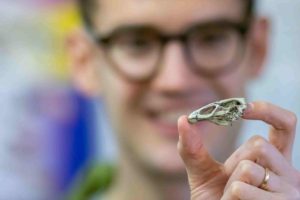
A tiny lizard forefoot of the genus Anolis is trapped in amber that is about 15 to 20 million years old. Credit: Jonas Barthel
The tiny forefoot of a lizard of the genus Anolis was trapped in amber about 15 to 20 million years ago. Every detail of this rare fossil is visible under the microscope. But the seemingly very good condition is deceptive: The bone is largely decomposed and chemically transformed, very little of the original structure remains. The results, which are now presented in the journal PLOS ONE, provide important clues as to what exactly happens during fossilization.
How do fossils stay preserved for millions of years? Rapid embedding is an important prerequisite for protecting the organisms from access by scavengers, for example. Decomposition by microorganisms can for instance be prevented by extreme aridity. In addition, the original substance is gradually replaced by minerals. The pressure from the sediment on top of the fossil ensures that the fossil is solidified. “That’s the theory,” says Jonas Barthel, a doctoral student at the Institute for Geosciences at the University of Bonn. “How exactly fossilization proceeds is currently the subject of intensive scientific investigation.”
Amber is considered an excellent preservative. Small animals can be enclosed in a drop of tree resin that hardens over time. A team of geoscientists from the University of Bonn has now examined an unusual find from the Dominican Republic: The tiny forefoot of a lizard of the genus Anolis is enclosed in a piece of amber only about two cubic centimeters in size. Anolis species still exist today.
Vertebrate inclusions in amber are very rare
The Stuttgart State Museum of Natural History has entrusted the exhibit to the paleontologists of the University of Bonn for examination. “Vertebrate inclusions in amber are very rare, the majority are insect fossils,” says Barthel. The scientists used the opportunity to investigate the fossilization of the seemingly very well preserved vertebrate fragment. Since 2018 there is a joint research project of the University of Bonn with the German Research Foundation, which contributes to the understanding of fossilization using experimental and analytical approaches. The present study was also conducted within the framework of this project.
The researchers had thin sections prepared for microscopy at the Institute for Evolutionary Biology at the University of Bonn. The claws and toes are very clearly visible in the honey-brown amber mass, almost as if the tree resin had only recently dripped onto them — yet the tiny foot is about 15 to 20 million years old.
Scans in the micro-computer tomograph of the Institute for Geosciences revealed that the forefoot was broken in two places. One of the fractures is surrounded by a slight swelling. “This is an indication that the lizard had perhaps been injured by a predator,” says Barthel. The other fracture happened after the fossil was embedded — exactly at the place where a small crack runs through the amber.
Amber did not protect from environmental influences
The analysis of a thin section of bone tissue using Raman spectroscopy revealed the state of the bone tissue. The mineral hydroxyapatite in the bone had been transformed into fluoroapatite by the penetration of fluorine. Barthel: “This is surprising, because we assumed that the surrounding amber largely protects the fossil from environmental influences.” However, the small crack may have encouraged chemical transformation by allowing mineral-rich solutions to find their way in. In addition, Raman spectroscopy shows that collagen, the bone’s elastic component, had largely degraded. Despite the seemingly very good state of preservation, there was actually very little left of the original tissue structure.
“We have to expect that at least in amber from the Dominican Republic, macromolecules are no longer detectable,” says the supervisor of the study, Prof. Dr. Jes Rust from the Institute for Geosciences. It was not possible to detect more complex molecules such as proteins, but final analyses are still pending. The degradation processes in this amber deposit are therefore very advanced, and there is very little left of the original substance.
Acids in tree resin attack bone
Amber is normally considered an ideal preservative: Due to the tree resin, we have important insights into the insect world of millions of years. But in the lizard’s bone tissue, the resin might even have accelerated the degradation processes: Acids in the tree secretion have probably attacked the apatite in the bone — similar to tooth decay.
Reference:
H. Jonas Barthel, Denis Fougerouse, Thorsten Geisler, Jes Rust. Fluoridation of a lizard bone embedded in Dominican amber suggests open-system behavior. PLOS ONE, 2020; 15 (2): e0228843 DOI: 10.1371/journal.pone.0228843
Maculaferrum blaisi, described in a study published in Acta Palaeontologica Polonica, is the first hemipteran insect (true bug) to be discovered at the Redmond Formation, a fossil site from the Cretaceous period near Schefferville, Labrador. Credit: Alexandre V. Demers-Potvin
A fossilised insect wing discovered in an abandoned mine in Labrador has led palaeontologists from McGill University and the University of Gdańsk to identify a new hairy cicada species that lived around 100 million years ago.
Maculaferrum blaisi, described in a study published in Acta Palaeontologica Polonica, is the first hemipteran insect (true bug) to be discovered at the Redmond Formation, a fossil site from the Cretaceous period near Schefferville, Labrador.
Alexandre Demers-Potvin, a Master’s student under the supervision of Professor Hans Larsson, Director of the Redpath Museum at McGill, said that a single wing was sufficient to identify the family to which the insect belonged.
“We were easily able to demonstrate that the insect belonged to the Tettigarctidae family thanks to the pattern of the veins we observed on its wing,” said Demers-Potvin, who is also a 2018 National Geographic Explorer.
The genus name (Maculaferrum) is derived from the Latin words macula — spot — because of the spotted pattern found on parts of the wing and ferrum — iron — due to the high iron content of the red rocks found at the Redmond site. The species name — blaisi — is in honour of Roger A. Blais, who conducted the first survey of the Redmond Formation and of its fossils in 1957 while working for the Iron Ore Company of Canada.
“This gives us a better understanding of the site’s insect biodiversity during the Cretaceous, a time before the dinosaurs were wiped out,” Demers-Potvin added. “The finding also illustrates that rare species can be found at the Redmond mine and that it deserves the attention from the palaeontological community.”
“The find is exciting because it represents the oldest, diverse insect locality in Canada. It’s also from an exciting time during an evolutionary explosion of flowering plants and pollinating insects, that evolved into the terrestrial ecosystems of today,” said Larsson.
Reference:
Alexandre Demers-Potvin, Jacek Szwedo, Cassia Paragnani, Hans Larsson. First North American occurrence of hairy cicadas discovered in a Late Cretaceous (Cenomanian) exposure from Labrador, Canada. Acta Palaeontologica Polonica, 2020; 65 DOI: 10.4202/app.00669.2019
Mystery has long surrounded the evolution of Facivermis, a worm-like creature that lived approximately 518 million years ago in the Cambrian period. Credit: Franz Anthony
Scientists have discovered the earliest known example of an animal evolving to lose body parts it no longer needed.
Mystery has long surrounded the evolution of Facivermis, a worm-like creature that lived approximately 518 million years ago in the Cambrian period.
It had a long body and five pairs of spiny arms near its head, leading to suggestions it might be a “missing link” between legless cycloneuralian worms and a group of fossil animals called “lobopodians,” which had paired limbs all along their bodies.
But the new study — by the University of Exeter, Yunnan University and the Natural History Museum — reveals Facivermis was itself a lobopodian that lived a tube-dwelling lifestyle anchored on the sea floor, and so evolved to lose its lower limbs.
“A key piece of evidence was a fossil in which the lower portion of a Facivermis was surrounded by a tube,” said lead author Richard Howard.
“We don’t know the nature of the tube itself, but it shows the lower portion of the worm was anchored inside by a swollen rear end.
“Living like this, its lower limbs would not have been useful, and over time the species ceased to have them.
“Most of its relatives had three to nine sets of lower legs for walking, but our findings suggest Facivermis remained in place and used its upper limbs to filter food from the water.
“This is the earliest known example of ‘secondary loss’ — seen today in cases such as the loss of legs in snakes.”
The Cambrian period is seen as the dawn of animal life, and the researchers were fascinated to find a species evolving to be “more primitive” even at this early stage of evolution.
“We generally view organisms evolving from simple to more complex body plans, but occasionally we see the opposite occurring,” said senior author Dr Xiaoya Ma.
“What excited us in this study is that even at this early stage of animal evolution, secondary-loss modifications — and in this case, reverting ‘back’ to lose some of its legs — had already occurred.
“We’ve known about this species for about 30 years, but it’s only now that we’ve got a confident grasp of where it fits in the evolutionary tree.
“Studies like this help us understand the shape of the tree of life and figure out where the adaptations and body parts we now see have come from.”
Co-author Greg Edgecombe, of the Natural History Museum, said: “For several years we and others have been finding lobopodians from the Cambrian period with pairs of appendages along the length of the body — long, grasping ones in the front, and shorter, clawed ones in the back.
“But Facivermis takes this to the extreme, by completely reducing the posterior batch.”
The Chengjiang Biota in Yunnan Province, south-west China has been a source of well-preserved Facivermis fossils.
Using these fossils, the study placed Facivermis in the Cambrian lobopodian group, which gave rise to three modern animal groups (phyla): Arthropoda (including insects, shrimps and spiders), Tardigrada (water bears) and Onychophora (velvet worms).
The research was funded by the Natural History Museum and the Natural Environment Research Council (NERC).
Reference:
Richard J. Howard, Xianguang Hou, Gregory D. Edgecombe, Tobias Salge, Xiaomei Shi, Xiaoya Ma. A Tube-Dwelling Early Cambrian Lobopodian. Current Biology, 2020; DOI: 10.1016/j.cub.2020.01.075
Alaska Centennial Nugget : Largest Gold Nugget Ever Found in Alaska
The largest gold nugget ever found in Alaska is named the Alaska Centennial Nugget. It weighs a whopping 294.10 troy ounces, and was found near the town of Ruby, Alaska in 1998.
A number of big nuggets have been discovered in Alaska. Yes, Alaska is probably the best state in the U.S. to look for gold, especially if you’re looking for a BIG nugget.
Miners have been looking for gold in Alaska for more than 100 years now, and some spectacular nuggets have been found. Of all the gold found in Alaska, the Centennial Nugget in Alaska is the most spectacular of all the discoveries made here.
Barry Clay was a placer mining region that was known for producing big nuggets along Swift Creek. He was driving dirt with his bulldozer when his eye spotted something odd. He jumped out of the dozer, catching the ring. He knew immediately by weight that a huge gold nugget had been found. He buried the nugget under a nearby tree afterwards, until he could find out what to do with it.
As he finally took it to town for further study, it was determined he had discovered the largest nugget ever found in Alaska, and the second largest nugget ever found in the western hemisphere behind the Cortez nugget found in Mexico.
It was named the Centennial nugget because it was discovered on the Klondike Gold Rush’s 100th anniversary which took thousands of men north to Alaska in search of gold. His finding in 1998 indicates that a number of huge gold nuggets are still left to be found. They haven’t all been discovered, not by a long shot!
With the record high gold prices in recent years and the renewed interest in gold mining, there is a very good chance in the very near future that more large gold nuggets will be discovered.
There were also many other big nuggets found in the Ruby Mining District, including several nuggets that weighed over a pound.
Alaska has by far the most commercial mining operations compared to other states, mainly due to its miner friendly regulations in comparison to other states. Alaska has a reputation for large nuggets as well. Overall gold produced here is not as high as other states like California and Nevada, but if you want to find a huge gold nugget in the United States, Alaska is the best place to look.
This beautiful nugget wasn’t alone. It may be the largest to be found here, but several whoppers have been found around Ruby. Nearly all the waters in this area, including Ruby Creek, Long Creek, Poorman Creek, Moose Creek and Bear Gulch, have produced gold. Such drainages have also created some of the most valuable nuggets in Alaska.
Ruby is in this region the primary center for the mines. The city is located on the Yukon River and is the main supply source for the placer mines operating in this region. Some of Alaska’s richest placers were working in the areas around Ruby from 1910 to 1920. There are only a handful of commercial mining operations here today, but it is very probable that good nuggets are still unearthed here.
Gold nuggets are pieces of native gold which occur naturally. Water and erosion concentrate the accumulation of nuggets which are collected by the methods of placer or lode mining. Nuggets are also frequently found in leftover layers where veins or lodes that contain gold have decayed. Nuggets can also be found today in the tailing piles of former mining operations, in particular the tailings of old dredging operations.
Nuggets of composition are never totally pure, or 24K. The bulk of nuggets are pure around 20-22 K or 83-92 per cent. The “fineness” of nuggets is noted for their pureness. As an example “865 perfect” means the nugget will be 865 gold parts per thousand. The common impurities present in gold nuggets include copper and silver.
Can you imagine a 2,332 ounce nugget of solid gold? Considered the largest gold nugget ever found, the Welcome Stranger Nugget was discovered buried just inches below the surface in Moliagul, Victoria, Australia on February 5th, 1869. Unbelievable!
The Holtermann Nugget found at Hill End, New South Wales, Australia in 1872, at 290 kg. was huge, and indeed remains the largest single mass of gold ever discovered, but it can’t really be called a “nugget” in my book. We could go into hard rock vs placer, but the essence is that a gold nugget has left the lode at some point and is no longer in the host rock. The Holtermann was what the Aussies call “reef gold” after the quartz reefs sought after by the hard rock miners.
Found near Wedderburn, Australia in October 1980, the magnificent Hand of Faith gold nugget was found using a metal detector. This incredible treasure was discovered in a vertical position, laying just six inches below the surface. The Hand of Faith nugget weighs a massive 875 troy ounces (61 pounds, 11 ounces). Kevin Hiller and his family were prospecting behind their modest trailer home when they made this incredible discovery. It is impossible to imagine their excitement and joy; what an amazing find! The Hand of Faith is presently on display at the Golden Nugget Hotel and Casino in Las Vegas, Nevada, USA.
Nuggets are generally considered parts that broke off from the original gold mine and were taken to a new location through water or erosion. The Holtermann Nugget, by applying this description, the greatest mass of gold ever discovered, is not really a nugget. The Holtermann Nugget, discovered in October 1872, is “reef gold,” rather than a diamond nugget. Nonetheless, an amazing find was the Holtermann Nugget, discovered at Hill End, New South Wales, Australia. Reef gold, usually quartz, occurs as a “vein” included in rock. This nugget was a quartz reef. The gold was retrieved by scraping the rock around the vein in one giant piece which weighed 286 kilograms (about 630 pounds). The true weight of this gold mass is unknown as several pieces are believed to have been broken away in the excavation and mining process.
Throughout history several magnificent nuggets have been discovered:
Three large nuggets were found in Montana near the famed Alder Gulch, the most substantial weighing in at 42 pounds. Discovered by Thomas Ramon and Joseph Lefebre in January 1902, the nugget was the size of a man’s fist and very small, with impurities of only 5 per cent.
Early prospectors didn’t find all the gold in Montana. A gold nugget weighing about 2 pounds (27.5 ounces) is the largest gold nugget found in Montana during the last 80 years. The Highland Centennial Gold Nugget was recovered in September 1989 by the Stratton family while working a placer claim in the Highland Mountains south of Butte. The nugget is currently on display at the Mineral Museum at the University of Montana in Butte, Montana.
Alaska is famous for the gold discovered there including the Centennial Nugget found near Ruby, Alaska, on Swift Creek. This treasure discovery is reportedly the largest nugget ever discovered in Alaska and weights 294.1 troy ounces. About the height of a softball, Barry Clay found this formidable nugget in 1998. It has been donated, and is now in a private collection.
Another Alaskan nugget of note was found on Anvil Creek near Nome, Alaska on September 29th, 1901, the Anvil Nugget weighed 108 troy ounces.
California and gold go hand-in-hand. The largest nugget ever discovered in California was located in 1854 at Carson Hill above the Stanislaus River. The nugget weighed 195 pounds.
They may not look like much, but CI chondrites – small fragile meteorites as shown here – are thought to be our best compositional equivalents of the bulk material of our solar system.
The precursor of our planet, the proto-Earth, formed within a time span of approximately five million years, shows a new study from the Centre for Star and Planet Formation (StarPlan) at the Globe Institute at the University of Copenhagen.
On an astronomical scale, this is extremely fast, the researchers explain.
If you compare the solar system’s estimated 4.6 billion years of existence with a 24-hour period, the new results indicate that the proto-Earth formed in what corresponds to about a minute and a half.
Thus, the results from StarPlan break with the traditional theory that the proto-Earth formed by random collisions between larger and larger planetary bodies throughout several tens of millions of years — equivalent to about 5-15 minutes out of the above-mentioned fictional 24 hours of formation.
Instead, the new results support a more recent, alternative theory about the formation of planets through the accretion of cosmic dust. The study’s lead author, Associate Professor Martin Schiller, explains it as follows:
“The other idea is that we start from dust, essentially. Millimetre-sized objects, all coming together, raining down on the growing body and making the planet in one go,” he says, adding:
“Not only is this implication of the rapid formation of the Earth interesting for our solar system. It is also interesting to assess how likely it is for planets to form somewhere else in the galaxy.”
The bulk composition of the solar system
The key to the new finding came in the form of the most precise measurements of iron isotopes that have so far been published scientifically.
By studying the isotopic mixture of the metallic element in different meteorites, the researchers found only one type of meteoritic material with a composition similar to Earth: The so-called CI chondrites.
The researchers behind the study describe the dust in this fragile type of meteorite as our best equivalent to the bulk composition of the solar system itself. It was dust like this combined with gas that was funnelled via a circumstellar accretion disk onto the growing Sun.
This process lasted about five million years and our planets were made from material in this disk. Now, the researchers estimate that the proto-Earth’s ferrous core also formed already during this period, removing early accreted iron from the mantle.
Two different iron compositions
Other meteorites, for example from Mars, tell us that at the beginning the iron isotopic composition of material contributing to the growing Earth was different. Most likely due to thermal processing of dust close to the young sun, the researchers from StarPlan explain.
After our solar system’s first few hundred thousands of years it became cold enough for unprocessed CI dust from further out in the system to enter the accretion region of the proto-Earth.
“This added CI dust overprinted the iron composition in the Earth’s mantle, which is only possible if most of the previous iron was already removed into the core. That is why the core formation must have happened early,” Martin Schiller explains.
“If the Earth’s formation was a random process where you just smashed bodies together, you would never be able to compare the iron composition of the Earth to only one type of meteorite. You would get a mixture of everything,” he adds.
More planets, more water, perhaps more life
Based on the evidence for the theory that planets form through the accretion of cosmic dust, the researchers believe that the same process may occur elsewhere in the universe.
This means that also other planets may likely form much faster than if they grow solely from random collisions between objects in space.
This assumption is corroborated by the thousands of exoplanets — planets in other galaxies — that astronomers have discovered since the mid-nineties, explains Centre Leader and co-author of the study, Professor Martin Bizzarro:
“Now we know that planet formation happens everywhere. That we have generic mechanisms that work and make planetary systems. When we understand these mechanisms in our own solar system, we might make similar inferences about other planetary systems in the galaxy. Including at which point and how often water is accreted,” he says, adding:
“If the theory of early planetary accretion really is correct, water is likely just a by-product of the formation of a planet like the Earth — making the ingredients of life, as we know it, more likely to be found elsewhere in the universe.”
Reference:
Martin Schiller, Martin Bizzarro, Julien Siebert. Iron isotope evidence for very rapid accretion and differentiation of the proto-Earth. Science Advances, 2020; 6 (7): eaay7604 DOI: 10.1126/sciadv.aay7604
Asteroid strikes upset the environment and provide clues via the elements they leave behind. Now, University of Tsukuba researchers have linked elements that are enriched in the Cretaceous–Paleogene (KPg) boundary clays from Stevns Klint, Denmark, to the impact of the asteroid that produced the Chicxulub crater at the Yucatán Peninsula, Mexico. This corresponds to one of the “Big Five” mass extinctions, which occurred at the KPg boundary at the end of the Cretaceous, 66 million years ago. The findings provide a better understanding of which processes lead to enrichment of these types of elements—an understanding that may be applied to other geological boundary events as well.
In a study published in the Geological Society of America Bulletin, the researchers analyzed the concentrations of certain elements within the KPg boundary clays—such as copper, silver, and lead—to determine which processes led to the element enrichment after the end-Cretaceous asteroid impact. Two enriched components were found in the boundary layer, each with distinctly different compositions of elements. One component was incorporated in pyrite (FeS2), whereas the other component was not related to pyrite.
“Since the enrichments of elements in these two components of the boundary clay were accompanied by enrichments of iridium,” says first author Professor Teruyuki Maruoka, “both two components might have been induced by processes related to the asteroid impact.”
Iron oxides/hydroxides acted as a carrier phase that supplied chalcophile elements (elements concentrated in sulfide minerals) to the KPg boundary clays on the sea floor. The vapor cloud of the asteroid impact produced iron oxides/hydroxides, which could have carried chalcophile elements in oceans and been the source of iron in the pyrite grains holding chalcophile elements.
“These could have been incorporated into the pyrite as impurities,” explains Professor Maruoka. “Furthermore, both iron oxides/hydroxides and chalcophile elements could have been released to the environment from the rocks that were struck by the asteroid impact.”
Additionally, organic matter in the oceans could have accumulated copper and silver. As such matter degraded on the sea floor, it could have released these elements, which then formed copper- or silver-enriched grains in the KPg boundary clays. This, in turn, may have led to the formation of discrete grains that differ from pyrite. Acid rain that occurred after the end-Cretaceous asteroid impact could have supplied elements such as copper, silver, and lead to the ocean, as these elements are typical constituents of acid-soluble sulfides and were enriched in the second chalcophile component not related to pyrite.
These findings will hopefully provide further avenues to increase our understanding of the events around the end-Cretaceous impact, and potentially other major boundary events.
Reference:
Teruyuki Maruoka et al. Enrichment of chalcophile elements in seawater accompanying the end-Cretaceous impact event, GSA Bulletin (2020). DOI: 10.1130/B35403.1
Representative Image : Volcanic eruption in australia. Image courtesy of Pete Johnson
South American volcano showing early warning signs of ‘potential collapse’, research shows
One of South America’s most prominent volcanoes is producing early warning signals of a potential collapse, new research has shown.
Tungurahua volcano in Ecuador — known locally as “The Black Giant” — is displaying the hallmarks of flank instability, which could result in a colossal landslide.
New research, led by Dr James Hickey from the Camborne School of Mines, has suggested that the volcano’s recent activity has led to significant rapid deformation on the western flank.
The researchers believe that the driving force causing this deformation could lead to an increased risk of the flank collapsing, causing widespread damage to the surrounding local area.
The research recommends the volcano should be closely monitored to watch for stronger early warning signs of potential collapse.
The study is published in the journal Earth & Planetary Science Letters.
Dr Hickey, who is based at the University of Exeter’s Penryn Campus, Cornwall, said: “Using satellite data we have observed very rapid deformation of Tungurahua’s west flank, which our research suggests is caused by imbalances between magma being supplied and magma being erupted.”
Tungurahua volcano has a long history of flank collapse, and has also been frequently active since 1999. The activity in 1999 led to the evacuation of 25,000 people from nearby communities.
A previous eruption of Tungurahua, around 3,000 years ago, caused a prior, partial collapse of the west flank of the volcanic cone.
This collapse led to a wide-spread debris avalanche of moving rock, soil, snow and water that covered 80 square kilometres — the equivalent of more than 11,000 football fields.
Since then, the volcano has steadily been rebuilt over time, peaking with a steep-sided cone more than 5000 m in height.
However, the new west flank, above the site of the 3000 year old collapse, has shown repeated signs of rapid deformation while the other flanks remain stable.
The new research has shown that this deformation can be explained by shallow, temporary magma storage beneath the west flank. If this magma supply is continued, the sheer volume can cause stress to accumulate within the volcanic cone — and so promote new instability of the west flank and its potential collapse.
Dr Hickey added: “Magma supply is one of a number of factors that can cause or contribute to volcanic flank instability, so while there is a risk of possible flank collapse, the uncertainty of these natural systems also means it could remain stable. However, it’s definitely one to keep an eye on in the future.”
Reference:
James Hickey, Ryan Lloyd, Juliet Biggs, David Arnold, Patricia Mothes, Cyril Muller. Rapid localized flank inflation and implications for potential slope instability at Tungurahua volcano, Ecuador. Earth and Planetary Science Letters, 2020; 534: 116104 DOI: 10.1016/j.epsl.2020.116104
Researchers at the Smithsonian Tropical Research Institute (STRI) discovered a massive, 7,000-year-old fossilized coral reef near the institute’s Bocas del Toro Research Station in Panama. Spanning about 50 hectares, it rewards paleontologists with an unusual glimpse of a “pristine” reef that formed before humans arrived.
“All modern reefs in the Caribbean have been impacted in some way by humans,” said STRI staff scientist Aaron O’Dea. “We wanted to quantify that impact by comparing reefs that formed before and after human settlement.”
Using a large excavator, the team dug 4-meter-deep trenches into the fossil reef and bagged samples of rubble. They dated the reef with high resolution radiometric dating.
“The fossils are exquisitely preserved,” O’Dea said. “We found branching corals in life position with chemically pristine fossil preservation. Now we are classifying everything from snails and clams to sea urchins, sponge spicules and shark dermal denticles.”
Archaeological evidence from Bocas del Toro indicates that settlers did not make extensive use of marine resources until around 2,000 years ago. So, the fossilized reef predates human impact by a few thousand years. After comparing fossilized corals with corals from nearby reefs, the team was surprised to find a modern reef that closely resembled the pre-settlement reef. They dubbed this a “bright spot,” and asked why this reef is more similar to the prehistoric reef than the others.
“Most of the reefs in Bocas today look nothing like they did 7,000 years ago,” said Andrew Altieri, former STRI scientist and now assistant professor at the University of Florida, Gainesville. “That confirmed our expectations given what we know about recent deterioration caused by humans. So we were really surprised when we discovered one modern reef that is indistinguishable in its community composition to the ancient reefs.”
When the team cored this “bright spot” reef, they discovered that it had been in this state for centuries. “This suggests resilience,” said Mauro Lepore, former STRI post-doctoral fellow. “And that kind of information can be really powerful for conservation.”
“This finding begs the question of what’s so special about this reef,” O’Dea said. The team evaluated current environmental factors such as water quality, hypoxia, temperature, aspect and shape, but none of those explained why this reef is more like the pre-human impact reef. The only clues were that it was the furthest away from human activity and that the staghorn coral, which dominates the reef, had previously been shown to consist of clones resilient to white band disease.
More work is needed to understand why this bright spot persists in the face of human impacts. However, the team propose that these kinds of fossil records can help in conservation by establishing which ecosystems have been irrevocably altered and those which preserve elements of what was natural. Once identified, these “bright spots” could act as a guide to conserve other ecosystems.
Reference:
Aaron O’Dea et al, Defining variation in pre-human ecosystems can guide conservation: An example from a Caribbean coral reef, Scientific Reports (2020). DOI: 10.1038/s41598-020-59436-y
The discovery of a new species of prehistoric reptile from Germany is reported this week in Scientific Reports. The anatomical features of the species, named Vellbergia bartholomaei, add to our understanding of the early evolution of lepidosauromorphs.
Lepidosauromorphs are one of the largest and most diverse tetrapod lineages with over 10,500 species. Ancestors to modern-day lizards, snakes and reptiles known as tuataras, lepidosauromorph specimens have only been found across a few Triassic sites and their early evolution remains largely unknown.
Gabriela Sobral and colleagues discovered the small fossil within the Middle Triassic (247 to 237 million-year-old) deposits of Vellberg, Germany. Analyses suggest that the specimen is a previously unknown species of early lepidosauromorph. One of the smallest found at the site, it could represent the first juvenile fossil collected at Vellberg. V. bartholomaei differs from other lepidosauromorph species owing to its distinct characteristics, including narrow, slender and short teeth relative to the lower jaw, but shares a mosaic of features found in the predecessors of present-day lizards and tuataras. The findings, which suggest that Vellbergia may be a common ancestor of the two lineages, further our understanding of early reptile evolution.
The fossil adds to evidence implicating Vellberg as an important site for understanding early lepidosauromorph evolution. Owing to the poor fossil record for the Early Triassic period, specimens from the Middle Triassic are of fundamental importance to understanding how vertebrates recovered after the Permian–Triassic mass extinction (around 252 million years ago), the Earth’s most severe known extinction event, and how they diversified into modern species.
Reference:
A tiny new Middle Triassic stem-lepidosauromorph from Germany: implications for the early evolution of lepidosauromorphs and the Vellberg fauna, Scientific Reports (2020). DOI: 10.1038/s41598-020-58883-x
Note: The above post is reprinted from materials provided by Nature Publishing Group .
A group of Russian and German palaeontologists have described a previously unknown genus and species of prehistoric salamanders. The new amphibian is named Egoria malashichevi — in honor of Yegor Malashichev a talented scientist and associate professor of the Department of Vertebrate Zoology at St Petersburg University, who passed away at the end of 2018. Credit: Pavel Skutschas
A group of Russian and German palaeontologists have described a previously unknown genus and species of prehistoric salamanders. The new amphibian is named Egoria malashichevi—in honor of Yegor Malashichev a talented scientist and associate professor of the Department of Vertebrate Zoology at St Petersburg University, who passed away at the end of 2018.
The palaeontologists found the remains of the ancient amphibian at the Berezovsky quarry, a fossil locality in the Krasnoyarsk Krai near the town of Sharypovo. Fossils of ancient fish, various reptiles, mammals, herbivorous and predatory dinosaurs have been previously found there. The research materials were collected on field expeditions in the mid-2010s. In these expeditions the scientists from St Petersburg University worked alongside experts from the University of Bonn (Germany), the Tomsk State University, the Zoological Institute of the Russian Academy of Sciences, and the Sharypovo Museum of Local History and Nature.
Four vertebrate fossils enabled the scientists to declare the finding of a new genus and species. These were: three trunk vertebrae and the atlas—the first and, in the case of the salamander, the only cervical vertebra. Since the atlas is a highly specialised vertebra, providing for attachment and rotation movements of the skull, it has a rather complex structure, the scientists explain. It is therefore most suitable for describing a new species as it provides much information for analysis. The amphibian proved to have belonged to the geologically oldest stem salamanders.
It was not the first time that remains of ancient salamanders had been found at the Berezovsky quarry. One of them—a basal stem salamander Urupia monstrosa, named after the nearby Uryup River—was about 50-60 centimetres long. Another one—Kiyatriton krasnolutskii—was named after a local historian Sergei Krasnolutskii, the discoverer of the fossil locality Berezovsky quarry. By contrast, this one was quite small in size (about 10-15 centimetres) and looked more like modern Hynobiidae. The newly discovered salamander, judging by the size of the vertebrae, was of medium length (about 20 centimetres).
“Salamanders first appear in the fossil records in the Middle Jurassic, including representatives of both the present-day salamander families and the most primitive ones,” said Pavel Skutschas, associate professor of St Petersburg University, doctor of biology, expert in Mesozoic vertebrates. “When they had just appeared, salamanders made efforts to occupy different ecological niches. Thus, the stem salamanders filled the niche of large water bodies; while those close to the present-day salamanders found their niche in small water bodies. As for the newly discovered salamander, it occupied a middle position, although morphologically, it is closer to the primitive.”
The scientists not only described the external characteristics of the specimens, but were able to look inside the fossils. In this they were assisted by the experts from the “Centre of X-ray diffraction studies’ at the Research Park of St Petersburg University, where the specimens were scanned on up-to-date microtomography scanners. Based on the obtained data, the palaeontologists created 3-D reconstructions of the vertebrae and described their internal structure. As expected, it proved to be very similar to that of the large stem salamanders.
The ancient amphibian received the name Egoria malashichevi—in honour of Yegor Malashichev, associate professor of the Department of Vertebrate Zoology at St Petersburg University, who, among other things, studied the morphology of caudate amphibians. “Yegor Malashichev was a wonderful person and a very talented scientist. He supported aspiring palaeontologists and did everything to help them to stay in scientific research,” remarked Pavel Skutschas. Additionally, Malashichev studied the phenomenon of lateralisation (body asymmetries associated with the functioning of the nervous system), as well as other asymmetries in motor performance and visual perception. Yegor Malashichev’s professional career was almost exclusively connected with St Petersburg University. In 1996, he graduated from the Faculty of Biology and Soil Science. In 2000, he began to teach there, and in 2003, he defended his dissertation and was awarded a Ph.D. in biology. Sadly, in late 2018, he passed away unexpectedly.
The next step for the palaeontologists is to compare the bones of the ‘Berezovsky’ salamanders with the fossils from Great Britain: the ‘Kirtlington’ salamanders which were found at the Kirtlington quarry in Oxfordshire. The Siberian and British faunas of the mid-Jurassic time were very similar. Besides, the palaeontologists are aware of similar amphibians that lived in the territory of present-day England. “They may be representatives of the same genera. However, to ascertain this, a detailed comparison of the palaeontological collections is required. In the coming spring, our colleagues from England will come to St Petersburg to study our research materials. We may discover that Urupia and Egoria used to have a very wide habitat, extending across Europe and Asia,” said Pavel Skutschas.
View of Takarkori shelter from the west. Credit: Savino di Lernia, 2020
Catfish and tilapia make up many of the animal remains uncovered in the Saharan environment of the Takarkori rock shelter in southwestern Libya, according to a study published February 19, 2020 in the open-access journal PLOS ONE by Wim Van Neer from the the Natural History Museum in Belgium, Belgium and Savino di Lernia, Sapienza University of Rome, Italy, and colleagues.
Today, the Saharan Tadrart Acacus mountains are windy, hot, and hyperarid; however, the fossil record shows that for much of the early and middle Holocene (10,200 to 4650 years BP), this region was humid and rich in water as well as life, with evidence of multiple human settlements and diverse fauna.
Rock shelters within the Tadrart Acacus preserve not only significant floral and faunal remains, but also significant cultural artifacts and rock art due to early Holocene occupation of these shelters. In this study, the authors worked with the Libyan Department of Antiquities in excavating parts of the Takarkori rock shelter to identify and date animal remains found at this site and investigate shifts in the abundance and type of these animal remains over time.
Fish remains made up almost 80 percent of the entire find overall, which numbered 17,551 faunal remains total (19 percent of these were mammal remains, with bird, reptile, mollusc, and amphibian remains the last 1.3 percent). All of the fish and most of the other remains were determined to be human food refuse, due to cut marks and traces of burning—the two fish genera at Takarkori were identified as catfish and tilapia.
Based on the relative dates for these remains, the amount of fish decreased over time (from 90 percent of all remains 10,200-8000 years BP versus only 40 percent of all remains 5900-4650 years BP) as the number of mammal remains increased, suggesting the inhabitants of Takarkori gradually focused more on hunting/livestock. The authors also found the proportion of tilapia specifically decreased more significantly over time, which may have been because catfish have accessory breathing organs allowing them to breathe air and survive in shallow, high-temperature waters—further evidence that this now-desert environment became less favorable to fish as the aridity increased.
The authors add: “This study reveals the ancient hydrographic network of the Sahara and its interconnection with the Nile, providing crucial information on the dramatic climate changes that led to the formation of the largest hot desert in the world. Takarkori rock shelter has once again proved to be a real treasure for African archaeology and beyond: a fundamental place to reconstruct the complex dynamics between ancient human groups and their environment in a changing climate.”
Reference:
Van Neer W, Alhaique F, Wouters W, Dierickx K, Gala M, Goffette Q, et al. (2020) Aquatic fauna from the Takarkori rock shelter reveals the Holocene central Saharan climate and palaeohydrography. PLoS ONE 15(2): e0228588. doi.org/10.1371/journal.pone.0228588