Home Blog Page 4

A giant weak spot in Earth’s magnetic field is now half the size of Europe

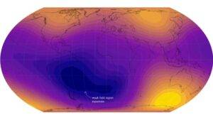
The South Atlantic Anomaly — a growing weak spot in Earth’s magnetic shield — has expanded by nearly half the size of continental Europe since 2014, with especially intense weakening now occurring near Africa. At the same time, magnetic strength is rising over Siberia and fading over Canada, reflecting powerful changes unfolding deep inside Earth’s core. Credit: ESA (Data source: Finlay, C.C. et al., 2025)

After analyzing 11 years of magnetic field data from the European Space Agency’s Swarm satellite constellation, researchers have found that a large weak zone in Earth’s magnetic field over the South Atlantic has grown dramatically. This region, called the South Atlantic Anomaly, has expanded since 2014 by an area nearly half the size of continental Europe.

Earth’s magnetic field plays a critical role in making the planet livable. It acts as a protective barrier, shielding us from harmful cosmic radiation and charged particles streaming from the Sun.

How Earth Generates Its Magnetic Field

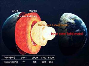
The magnetic field is produced deep inside the planet. Roughly 3000 km below the surface, a vast ocean of molten, churning liquid iron fills the outer core. As this electrically conductive material moves, it generates electric currents. Those currents create the ever changing electromagnetic field that surrounds Earth. Although it can be loosely compared to the motion of a spinning conductor in a bicycle dynamo, the true processes driving the field are far more complicated.

Swarm is an Earth Explorer mission developed under ESA’s Earth Observation FutureEO program. It consists of three identical satellites that measure magnetic signals originating from Earth’s core, mantle, crust, and oceans, along with contributions from the ionosphere and magnetosphere.

These detailed observations help scientists separate the different sources of magnetism and better understand why the magnetic field is weakening in some regions while strengthening in others.

Why the South Atlantic Anomaly Matters

The South Atlantic Anomaly was first identified in the 19th century southeast of South America. Today it is closely monitored because of its implications for space safety. Satellites passing through this region are exposed to elevated levels of radiation, increasing the risk of technical malfunctions, hardware damage, and even temporary outages.

New findings published in Physics of the Earth and Planetary Interiors show that the anomaly expanded steadily between 2014 and 2025. Since 2020, however, an area of the Atlantic southwest of Africa has experienced even more rapid magnetic weakening.

“The South Atlantic Anomaly is not just a single block,” says lead author Chris Finlay, Professor of Geomagnetism at the Technical University of Denmark. “It’s changing differently towards Africa than it is near South America. There’s something special happening in this region that is causing the field to weaken in a more intense way.”

Reverse Flux Patches and Core Dynamics

Scientists link this unusual behavior to patterns in the magnetic field at the boundary between Earth’s liquid outer core and its solid mantle. These features, known as reverse flux patches, represent areas where the magnetic field behaves in an unexpected way.

Prof. Finlay explains, “Normally we’d expect to see magnetic field lines coming out of the core in the southern hemisphere. But beneath the South Atlantic Anomaly we see unexpected areas where the magnetic field, instead of coming out of the core, goes back into the core. Thanks to the Swarm data we can see one of these areas moving westward over Africa, which contributes to the weakening of the South Atlantic Anomaly in this region.”

Swarm Sets a New Magnetic Record

The latest magnetic field model marks an important milestone for Swarm. The mission now holds the longest continuous space based record of Earth’s magnetic field.

Launched on November 22, 2013, as the fourth Earth Explorer mission, the satellites were designed to test advanced Earth observation technologies. They have exceeded their planned lifetime and become essential for maintaining long term magnetic field records, supporting operational services, and guiding future satellite missions.

Swarm measurements form the foundation of global magnetic models used for navigation, tracking space weather hazards, and studying Earth’s system from its deep interior to the upper atmosphere.

Magnetic Field Strength Grows Over Siberia

The new results also highlight how dynamic Earth’s magnetism truly is. In the southern hemisphere, there is one region where the magnetic field is especially strong. In the northern hemisphere, there are two such areas, one near Canada and another over Siberia.

“When you’re trying to understand Earth’s magnetic field, it’s important to remember that it’s not just a simple dipole, like a bar magnet. It’s only by having satellites like Swarm that we can fully map this structure and see it changing,” said Prof. Finlay.

Since Swarm began operating, the magnetic field over Siberia has intensified while the field over Canada has weakened. The strong magnetic region over Canada has shrunk by 0.65% of Earth’s surface area, roughly the size of India. In contrast, the Siberian strong field region has expanded by 0.42% of Earth’s surface area, comparable to the size of Greenland.

These changes are driven by complex activity in Earth’s turbulent core and are connected to the gradual movement of the northern magnetic pole toward Siberia in recent years. This ongoing shift affects navigation systems, which depend on the balance between these strong magnetic regions.

ESA’s Swarm Mission Manager, Anja Stromme, said, “It’s really wonderful to see the big picture of our dynamic Earth thanks to Swarm’s extended timeseries. The satellites are all healthy and providing excellent data, so we can hopefully extend that record beyond 2030, when the solar minimum will allow more unprecedented insights into our planet.”

Reference:
C.C. Finlay, C. Kloss, N. Gillet. Core field changes from eleven years of Swarm satellite observations. Physics of the Earth and Planetary Interiors, 2025; 368: 107447 DOI: 10.1016/j.pepi.2025.107447

Note: The above post is reprinted from materials provided by European Space Agency (ESA).
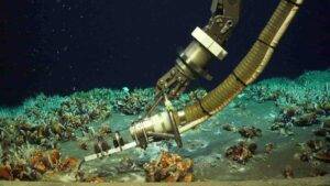
Scientists discover a hidden deep sea hotspot bursting with life

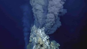
Measuring the temperature on the seafloor: In the newly discovered hydrothermal field, hot liquid and cold gas bubble up from the sediment just a few centimeters apart. Credit: ROV Kiel 6000 / GEOMAR

Off the coast of Papua New Guinea, scientists have identified a previously unknown type of hydrothermal field where two different processes occur at the same time: hot hydrothermal fluids rise from below the seafloor while unusually large quantities of methane and other hydrocarbons escape from the sediments. This combination has not been documented anywhere else. The site is located about 1,300 meters deep on the slope of Conical Seamount in the western Pacific, near the island of Lihir in Papua New Guinea.

The findings were recently described in Scientific Reports.

ROV delivers the surprise

“We essentially have a hot vent bubbling right next to a cool gas seep — a combination that has never been described before,” says Dr. Philipp Brandl, marine geologist at the GEOMAR Helmholtz Centre for Ocean Research Kiel. He was chief scientist on the SONNE expedition SO299 DYNAMET, which surveyed the Tabar-Lihir-Tanga-Feni island chain in 2023 to investigate the region’s underwater volcanoes (seamounts).

Brandl adds: “No one really expected to find a hydrothermal field here, let alone one that is so exceptional.” Earlier missions had shown hints of limited hydrothermal activity, yet this field went unnoticed during several previous research cruises. Only when the team deployed the ROV Kiel 6000 did the unusual features of the site become clear. “It was a real surprise,” Brandl says, “especially for those of us who had worked in this area multiple times.”

A hybrid system of hot and cool vents

Hydrothermal vents and methane seeps typically appear in separate locations on the seafloor. In this instance, however, their close spacing results from the specific makeup of Conical Seamount. Thick layers of sediment rich in organic material lie beneath the volcanic edifice. Rising magma heats these buried layers, producing methane and other hydrocarbons. At the same time, the heat from the magma drives chemically rich fluids upward until they exit the seafloor as hot hydrothermal vents.

Both the heated fluids from below and the cooler, methane-filled gases from the sediments move upward through the same pathways. As a result, hot water and cold gas emerge from the seafloor only a few centimeters apart.

A habitat unlike any other

This unusual arrangement creates an entirely new kind of deep-sea environment that supports an exceptionally varied community of organisms. The rocks are densely covered by Bathymodiolus mussels, tube worms, shrimp, amphipods, and vivid purple sea cucumbers. “In places, you couldn’t see a single patch of rock because everything is so densely populated,” Brandl says. “We are confident that some of the species there have not yet been described. However, a dedicated expedition would be needed to fully study this unique habitat.”

Because mussels dominate the area, the research team and local observer Stanis Konabe from the University of Papua New Guinea named the site ‘Karambusel’. In Tok Pisin, the word means ‘mussel’.

Traces of precious metals in the rock

The unusual mixture of gases at Karambusel affects both the ecosystem and the geological characteristics of the vent field. Methane levels exceed 80 percent, and hot fluids rising from below create distinctive chemical conditions in the subsurface. Gold and silver, along with arsenic, antimony, and mercury, accumulate in the surrounding rocks. These minerals indicate that the area once experienced high-temperature hydrothermal activity that deposited precious metals, even though current activity is cooler.

Threats from human activity

Although the site is remarkable for both its geology and its biology, it faces significant risks. Mining operations already occur nearby, such as at the Ladolam gold mine on Lihir, where waste material is discharged into the ocean. Additional exploration licences for seafloor minerals and hydrocarbons are in place. These activities pose threats to the delicate ecosystem and the organisms that depend on it.

The researchers urge further investigation of this region, along with careful marine spatial planning and protective measures to safeguard the site. Philipp Brandl states: “We have discovered an unexpected treasure trove of biodiversity in the Karambusel field that needs to be protected before economic interests destroy it.”

Reference:

Philipp A. Brandl, Sylvia G. Sander, Christoph Beier, Mark Schmidt, Jan J. Falkenberg, Terue Kihara, Klaas Meyn, Felix Genske, Rebecca Zitoun, Brent I. A. McInnes, Mark D. Hannington, Sven Petersen, Eemu J. Ranta, Fred Jourdan, Louis-Maxime Gautreau, Thor H. Hansteen, Ingo Heyde, Stanis Konabe, Joseph O. Espi, Octavio Acuña Avendaño, Alan T. Baxter, Christophe Y. Galerne, Max Kaufmann, Johanna Klein, Sabine Lange, Doris Maicher, Esther Panachi, Konstantin Reeck, Egor Riemer, William Ruth, Johanna Schenk, Sarima Vahrenkamp, Leon Waßmund, Julia Wenske, Hannah Zimmer. Coupled hydrothermal venting and hydrocarbon seepage discovered at Conical Seamount, Papua New Guinea. Scientific Reports, 2025; 15 (1) DOI: 10.1038/s41598-025-17192-x

Note: The above post is reprinted from materials provided by Helmholtz Centre for Ocean Research Kiel (GEOMAR).

Physical Properties of Iron Alloys in the Superionic State at Earth’s Core Conditions

The inner core, outer core, mantle and Earth’s crust.

Physical Properties of Iron Alloys in the Superionic State at Earth’s Core Conditions

The concept of a Superionic Earth Core challenges the classical view of Earth’s inner core as a purely solid iron–nickel alloy. Recent high-pressure experiments and first-principles simulations suggest that under extreme temperature and pressure conditions, iron alloys containing light elements (H, C, O, Si, S) may enter a superionic state—a phase where one atomic sublattice remains solid while lighter elements become partially mobile, behaving like a liquid within a crystalline framework.

This emerging model has profound implications for inner core physics, geodynamics, seismic anisotropy, and the long-term stability of Earth’s magnetic field.

To understand whether Earth’s inner core may host superionic behavior, we must examine the physical conditions, experimental constraints, mineral physics, and thermodynamic mechanisms operating at depths of ~5,100–6,371 km.

What Is a Superionic State? A Mineral Physics Perspective

Definition of Superionic Matter

A superionic state is a phase of matter in which:

  • One component (typically heavier atoms) forms a rigid crystalline lattice.
  • Another component (usually lighter ions such as hydrogen or oxygen) becomes highly mobile.
  • The material exhibits both solid-like and liquid-like properties simultaneously.

Superionic phases were first observed in materials such as AgI and later predicted for planetary ices (e.g., water at Uranus–Neptune conditions). Under extreme pressures and temperatures, ionic mobility increases dramatically without complete melting.

In the context of the Superionic Earth Core, the key question is whether iron alloys under core conditions exhibit similar behavior.

Physical Conditions at Earth’s Inner Core

Pressure and Temperature Regime

The inner core exists under:

  • Pressures of ~330–360 GPa
  • Temperatures estimated between 5,000–6,500 K

These extreme conditions are replicated experimentally using:

  • Diamond anvil cells
  • Laser-heated compression experiments
  • Shock compression methods

Such conditions approach the melting boundary of iron alloys and may stabilize unusual high-temperature phases.

Composition of the Inner Core — Beyond Pure Iron

Seismic density measurements indicate that Earth’s core is not pure iron. It must contain 5–10 wt% light elements, inferred from density deficits relative to pure Fe at core pressures.

Candidate Light Elements

Commonly proposed light elements include:

  • Hydrogen (H)
  • Carbon (C)
  • Oxygen (O)
  • Silicon (Si)
  • Sulfur (S)

The incorporation of light elements alters:

  • Melting temperature
  • Electrical conductivity
  • Sound velocity
  • Diffusion rates

These compositional effects are central to evaluating superionic behavior.

Experimental Evidence for Superionic Behavior in Iron Alloys

Hydrogen-Bearing Iron Alloys

First-principles molecular dynamics simulations suggest that Fe–H systems under core conditions may allow hydrogen to diffuse rapidly through an iron lattice. At sufficiently high temperatures, hydrogen mobility resembles liquid diffusion while the iron framework remains crystalline.

This diffusion resembles superionic phases predicted in high-pressure ices and oxides.

Oxygen and Other Light Elements

Experimental studies of Fe–O and Fe–Si alloys indicate possible decoupling between heavy and light atomic mobility at extreme conditions. While not definitively proven in the inner core, these findings support the plausibility of partial ionic mobility.

Implications for Inner Core Physics

Seismic Anisotropy

Earth’s inner core exhibits seismic anisotropy, where P-waves travel faster along polar directions than equatorial ones. A superionic state could influence:

  • Elastic constants
  • Crystal alignment
  • Diffusion-assisted recrystallization

Superionic mobility may contribute to anisotropic behavior via enhanced lattice reorganization.

Thermal Conductivity

The mobility of light elements affects:

  • Heat transport efficiency
  • Core cooling rates
  • Energy available for convection in the outer core

If the inner core hosts superionic properties, it may modify estimates of the heat flux driving the geodynamo.

Connection to the Geodynamo and Magnetic Field

Role of the Inner Core in Magnetic Field Generation

Earth’s magnetic field originates primarily in the liquid outer core, where convection of electrically conductive iron generates a self-sustaining dynamo.

However, the inner core influences this system by:

  • Releasing latent heat during solidification
  • Expelling light elements into the outer core
  • Contributing compositional buoyancy

If the inner core exhibits partial superionic behavior, the exchange of light elements between solid and liquid regions may alter buoyancy flux and magnetic field stability.

Thermodynamics of the Superionic Transition

Melting vs Superionic Transition

A superionic transition differs from full melting:

  • Lattice framework persists
  • Partial ionic disorder occurs
  • Electrical and thermal properties change nonlinearly

Phase diagrams of Fe–light element systems at 300+ GPa suggest complex transitions that are not fully constrained experimentally.

Challenges and Open Questions

Despite compelling theoretical work, several uncertainties remain:

  • Is superionic behavior stable under inner core pressure–temperature conditions?
  • What is the exact composition of the core?
  • How does long-term diffusion affect core evolution?
  • Can seismic observations distinguish superionic phases from conventional solid phases?

Resolving these questions requires advances in:

  • High-pressure mineral physics
  • Synchrotron experiments
  • Ab initio simulations
  • Seismic modeling

Broader Implications for Planetary Science

The concept of a Superionic Earth Core also informs the study of:

  • Superionic water in ice giants
  • Core states of terrestrial exoplanets
  • Evolution of planetary magnetic fields

If superionic phases are common under extreme planetary conditions, they may represent a fundamental state of matter in planetary interiors.

References 

  1. Hirose, K., Labrosse, S., & Hernlund, J. (2013). Composition and state of the core. Annual Review of Earth and Planetary Sciences, 41, 657–691.
  2. Pozzo, M., Davies, C., Gubbins, D., & Alfè, D. (2012). Thermal and electrical conductivity of iron at Earth’s core conditions. Nature, 485, 355–358.
  3. Umemoto, K., & Wentzcovitch, R. M. (2011). Ab initio study of Fe–H systems at high pressure. Earth and Planetary Science Letters, 311, 225–229.
  4. Ohta, K., et al. (2016). Experimental determination of electrical resistivity of iron at core conditions. Nature, 534, 95–98.
  5. McDonough, W. F. (2014). Compositional model for Earth’s core. Treatise on Geochemistry, 3, 559–577.
  6. French, M., Mattsson, T. R., Nettelmann, N., & Redmer, R. (2009). Equation of state and phase diagram of water at extreme conditions. Physical Review B, 79, 054107.

Mantle Plume Initiation and the Role of Large Low-Shear-Velocity Provinces (LLSVPs)

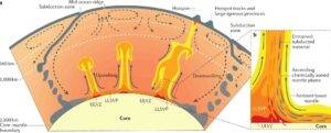
Dynamic nature of Earth’s interior.

Introduction — Why “Mantle Blobs” Matter in Deep Earth Science

Large Low-Shear-Velocity Provinces (LLSVPs), often informally called mantle blobs, represent some of the most enigmatic and fundamental structures within Earth’s interior. Identified through global seismic tomography, LLSVPs are vast regions at the base of the mantle, near the core–mantle boundary (CMB), where seismic shear waves (S-waves) travel anomalously slowly.

Understanding LLSVPs is essential because they are increasingly linked to:

  • Mantle plume initiation
  • The location of hotspots and large igneous provinces (LIPs)
  • Long-term mantle convection patterns
  • The thermal and chemical evolution of Earth

In modern deep-Earth geodynamics, LLSVPs are no longer considered passive anomalies. Instead, they are thought to play an active, organizing role in how heat and material are transferred from the deep mantle to the surface.

What Are LLSVPs? A Seismological Definition

Seismic Characteristics of LLSVPs

LLSVPs are defined as regions of markedly reduced shear-wave velocity in the lowermost mantle, typically extending several hundred kilometers above the core–mantle boundary.

Key defining features include:

  • Shear-wave velocity reductions of 1–3% relative to surrounding mantle
  • Lateral dimensions on the order of thousands of kilometers
  • Vertical thicknesses of 200–1000 km
  • Sharp lateral boundaries detectable in high-resolution tomography

Two dominant LLSVPs have been consistently imaged:

  • One beneath Africa
  • One beneath the central Pacific

These structures have remained stable over hundreds of millions of years, suggesting a fundamental role in mantle dynamics.

Discovery Through Seismic Tomography

How Seismic Tomography Reveals Deep Mantle Structure

Seismic tomography works by analyzing variations in seismic wave travel times from earthquakes recorded worldwide. Slower-than-expected S-wave velocities indicate:

  • Elevated temperatures
  • Chemical heterogeneity
  • Partial melt or compositional anomalies

The recognition of LLSVPs emerged in the late 20th century as global datasets improved, revealing coherent, continent-scale low-velocity provinces at the base of the mantle rather than random thermal anomalies.

Thermal vs Chemical Nature of LLSVPs

A central scientific debate concerns what LLSVPs are made of.

Thermal Anomaly Hypothesis

In a purely thermal interpretation, LLSVPs represent:

  • Hot, buoyant regions
  • Accumulations of heat above the core
  • Long-lived thermal reservoirs

However, temperature alone cannot fully explain:

  • Their sharp boundaries
  • Their long-term stability against convective mixing

Thermochemical Pile Hypothesis

The prevailing model interprets LLSVPs as thermochemical piles, meaning they are:

  • Hotter and compositionally distinct
  • Enriched in dense materials such as recycled oceanic crust
  • Stabilized by chemical density contrasts

This model explains both seismic observations and the persistence of LLSVPs over geological time.

Origin of LLSVPs in Earth History

Accumulation of Subducted Slabs

One leading hypothesis suggests that LLSVPs formed through:

  • Long-term subduction of oceanic lithosphere
  • Sinking slabs reaching the lowermost mantle
  • Chemical segregation and accumulation near the CMB

Over billions of years, this process may have produced compositionally distinct mantle reservoirs.

Primordial Mantle Reservoirs

An alternative view proposes that LLSVPs represent primordial mantle domains, preserved since Earth’s early differentiation. Isotopic signatures from plume-related basalts support the existence of deep, ancient mantle sources.

LLSVPs and Mantle Plume Initiation

Why Plumes Prefer LLSVP Margins

One of the strongest links between LLSVPs and surface geology is the observation that mantle plumes preferentially originate at the edges of LLSVPs rather than their centers.

This occurs because:

  • Strong lateral thermal gradients exist at LLSVP margins
  • Instabilities develop where hot, dense material meets cooler mantle
  • These instabilities evolve into buoyant plume upwellings

This relationship explains why many hotspots and LIPs cluster geographically above inferred LLSVP boundaries.

Connection to Large Igneous Provinces and Hotspots

Large Igneous Provinces (LIPs)

Geochronological reconstructions show that many LIPs erupted above present-day or reconstructed LLSVP margins, including:

  • Deccan Traps
  • Karoo–Ferrar province
  • Ontong Java Plateau

This spatial correlation strongly supports a deep-mantle control on surface magmatism.

Hotspot Stability

Long-lived hotspots such as Hawaii and Réunion are thought to be fed by plumes rooted near LLSVPs, explaining their persistence over tens of millions of years despite plate motion.

LLSVPs and Global Mantle Convection

Influence on Mantle Flow Patterns

LLSVPs act as large-scale boundary conditions for mantle convection by:

  • Deflecting descending slabs
  • Anchoring plume generation zones
  • Organizing long-wavelength mantle circulation

Rather than a chaotic system, Earth’s mantle appears structured around these deep reservoirs.

Interaction with the Core–Mantle Boundary

LLSVPs sit directly above the outer core, influencing:

  • Heat flux from the core
  • Core cooling rates
  • Potential links to the geodynamo

This coupling highlights the importance of LLSVPs in whole-Earth dynamics.

Implications for Plate Tectonics

Deep Control on Surface Plates

Although plate tectonics operates at the surface, LLSVPs may indirectly influence:

  • Plate boundary reorganization
  • Supercontinent cycles
  • Long-term distribution of volcanism

This challenges the traditional view that mantle convection is driven only from the top down.

Competing Models and Open Questions

Despite major advances, key questions remain:

  • Are LLSVPs primarily thermal, chemical, or both?
  • How sharp are their boundaries at mineralogical scales?
  • Do they evolve over time, or are they quasi-permanent?

Future progress depends on integrating seismology, mineral physics, geochemistry, and numerical modeling.

Why LLSVPs Matter Beyond Academia

Understanding LLSVPs has implications for:

  • Interpreting mantle-derived geochemical signatures
  • Predicting long-term volcanic patterns
  • Modeling Earth’s thermal evolution
  • Constraining deep carbon and volatile cycles

In short, LLSVPs are central to explaining how Earth works as a coupled deep-to-surface system.

References

  • Garnero, E. J., McNamara, A. K., & Shim, S.-H. (2016). Continent-sized anomalous zones with low seismic velocity at the base of the mantle. Nature Geoscience, 9, 481–489.
  • Burke, K., Steinberger, B., Torsvik, T. H., & Smethurst, M. A. (2008). Plume generation zones at the margins of large low shear velocity provinces. Earth and Planetary Science Letters, 265, 49–60.
  • McNamara, A. K., & Zhong, S. (2005). Thermochemical structures within a spherical mantle. Journal of Geophysical Research, 110, B07402.
  • Dziewonski, A. M., Lekic, V., & Romanowicz, B. A. (2010). Mantle anchor structure. Earth and Planetary Science Letters, 299, 69–79.
  • Torsvik, T. H., et al. (2014). Deep mantle structure as a reference frame for plate motion. Nature, 514, 400–404.
  • Li, M., McNamara, A. K., & Garnero, E. J. (2014). Chemical complexity of hotspots caused by cycling oceanic crust through mantle plumes. Nature Geoscience, 7, 366–370.

Niobium Carbonatites: Petrology and Mineralization Processes

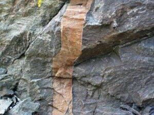
Calciocarbonatite in the Precambrian of Ontario, Canada.

Introduction — Why Carbonatites Matter in the Critical Minerals Era

Carbonatite complexes occupy a unique and strategically important position in global geology. Although volumetrically rare, carbonatites are the primary global source of niobium (Nb)—a critical metal essential for high-strength low-alloy steels, aerospace components, energy infrastructure, and advanced technologies. As demand for critical minerals intensifies, understanding the petrological evolution of niobium-bearing carbonatites has become central to both academic research and mineral exploration strategies.

From a geological perspective, carbonatites are extraordinary because they represent carbonate-dominated magmas derived from the mantle, challenging long-standing models of silicate-dominated magmatism. Their evolution involves complex interactions between mantle source heterogeneity, partial melting, fractional crystallization, immiscibility, and hydrothermal processes, all of which play a role in concentrating niobium into economically viable deposits.

What Are Carbonatites? A Petrological Definition

Carbonatites are igneous rocks composed of more than 50% carbonate minerals by volume, primarily calcite, dolomite, or ankerite. Unlike sedimentary carbonates, carbonatites are unequivocally magmatic in origin, as demonstrated by their textures, mineral assemblages, isotope compositions, and spatial association with alkaline silicate rocks.

Mineralogical Composition of Carbonatites

Typical carbonatites contain:

  • Carbonate minerals (calcite, dolomite, ferroan carbonates)
  • Accessory phases such as apatite, magnetite, barite, fluorite
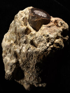
  • Nb-bearing minerals, most notably pyrochlore-group minerals
  • Enrichment in incompatible elements (Nb, REE, Sr, Ba, Th, U)

This unusual chemistry reflects their derivation from low-degree partial melts of a metasomatized mantle source.

Global Distribution and Tectonic Setting of Carbonatite Complexes

Carbonatites are spatially associated with intraplate tectonic environments, commonly occurring within:

  • Continental rift zones
  • Cratonic margins
  • Stable continental interiors affected by mantle upwelling

They are frequently linked to alkaline igneous complexes, forming ring structures, cone sheets, and multi-phase intrusive centers.

Mantle Plumes and Lithospheric Control

Geophysical and geochemical evidence indicates that many carbonatite complexes originate from mantle plume-related thermal anomalies, combined with lithospheric thinning or reactivation of deep-seated structures. This tectonic configuration facilitates:

  • Low-degree partial melting
  • Ascent of volatile-rich melts
  • Long-lived magmatic systems capable of extreme elemental fractionation

Carbonatite Petrogenesis — From Mantle to Crust

Understanding carbonatite petrogenesis is fundamental to explaining niobium enrichment.

Mantle Source Characteristics

Isotopic data (Sr–Nd–Pb–C–O) consistently indicate derivation from a heterogeneous, metasomatized subcontinental lithospheric mantle. This mantle source has been enriched by:

  • Carbonate-rich melts
  • Alkali- and volatile-bearing fluids
  • Recycled subducted materials

These processes introduce niobium and other incompatible elements into mantle domains capable of generating carbonatitic melts.

Partial Melting and Melt Generation

Carbonatite magmas are produced by:

  • Extremely low degrees of partial melting (<1%)
  • Melting of carbonated peridotite or eclogite
  • Stabilization of carbonate melts at lower temperatures than silicate melts

Such low-degree melts are inherently enriched in Nb, REE, and volatiles, setting the stage for mineralization.

Evolution of Carbonatite Magmas in the Crust

Once generated, carbonatite magmas undergo complex evolutionary pathways.

Magma Ascent and Emplacement

Carbonatite magmas ascend rapidly due to:

  • Low viscosity
  • High volatile content
  • Buoyancy relative to surrounding rocks

They commonly intrude as:

  • Dykes
  • Cone sheets
  • Plug-like bodies
  • Zoned intrusive complexes

Fractional Crystallization

As carbonatite magmas cool, early crystallization of carbonate and oxide minerals leads to progressive enrichment of incompatible elements, including niobium, in the residual melt. This process is critical in achieving ore-grade concentrations.

Immiscibility and the Silicate–Carbonatite Link

One of the most important processes in carbonatite evolution is liquid immiscibility.

Silicate–Carbonate Melt Separation

Experimental and natural studies demonstrate that alkaline silicate magmas can unmix into:

  • A silicate-rich melt
  • A carbonate-rich (carbonatitic) melt

This immiscibility process:

  • Concentrates Nb into the carbonatitic melt
  • Explains the intimate spatial association of carbonatites with nepheline syenites, ijolites, and phonolites

Niobium Min`2eralization in Carbonatite Complexes

Why Niobium Concentrates in Carbonatites

Niobium is a high-field-strength element (HFSE) with limited compatibility in major silicate minerals. In carbonatite systems:

  • Nb remains in the melt during early crystallization
  • Volatile-rich conditions suppress Nb incorporation into early phases
  • Late-stage melts become extremely Nb-rich

Pyrochlore-Group Minerals

The dominant niobium ore mineral in carbonatites is pyrochlore, typically occurring as:

  • Magmatic crystals
  • Hydrothermally altered phases
  • Zoned grains recording magmatic evolution

Pyrochlore chemistry reflects:

  • Redox conditions
  • Magma composition
  • Degree of hydrothermal overprinting

Hydrothermal Processes and Ore Upgrading

Role of Late-Stage Fluids

Post-magmatic hydrothermal fluids play a crucial role by:

  • Redistributing niobium
  • Altering primary pyrochlore
  • Enhancing ore grade through dissolution–reprecipitation processes

Fluids rich in F, CO₂, and alkalis are particularly effective in mobilizing HFSEs.

Structural Controls on Mineralization

Faults, fractures, and breccia zones provide:

  • Pathways for fluid flow
  • Sites for mineral precipitation
  • Controls on ore geometry and continuity

Carbonatites and Critical Mineral Exploration

Exploration Indicators for Niobium Carbonatites

Successful exploration relies on recognizing:

  • Association with alkaline complexes
  • Geophysical anomalies (magnetic, gravity)
  • Geochemical halos enriched in Nb, REE, P, Sr, Ba
  • Presence of pyrochlore and apatite-rich zones

Economic Significance

Major niobium deposits hosted by carbonatites supply the majority of global Nb demand, making these systems strategic assets in critical mineral supply chains.

Geological and Economic Implications

Carbonatite-hosted niobium deposits demonstrate how:

  • Mantle processes directly influence resource distribution
  • Rare magmatic systems can dominate global supply
  • Understanding petrology is essential for sustainable exploration

As the global transition toward low-carbon and high-performance technologies accelerates, niobium carbonatites will remain at the forefront of critical mineral geology.

References

  • Woolley, A. R., & Kjarsgaard, B. A. (2008). Carbonatite occurrences of the world. Geological Survey of Canada.
  • Mitchell, R. H. (2005). Carbonatites and Carbonatites and Carbonatite Petrogenesis. Mineralogical Association of Canada.
  • Bell, K., & Tilton, G. R. (2001). Nd, Pb and Sr isotopic compositions of carbonatites. Journal of Petrology, 42, 959–988.
  • Chakhmouradian, A. R., & Zaitsev, A. N. (2012). Rare earth mineralization in carbonatites. Elements, 8, 333–338.
  • Kjarsgaard, B. A., & Hamilton, D. L. (1989). Carbonatite–nephelinite liquid immiscibility. Journal of Petrology, 30, 939–974.
  • Mariano, A. N. (1989). Economic geology of rare earth minerals. Reviews in Mineralogy, 21, 309–348.

16,000 fossil footprints in central Bolivia reveal dinosaur behavior

A petrified footprint by a dinosaur is visible in Carreras Pampa in Toro Toro National Park, north of Potosi, Bolivia, Saturday, Dec. 6, 2025. Credit: AP Photo/Juan Karita

Legend once had it that the huge, three-toed footprints scattered across the central highlands of Bolivia came from supernaturally strong monsters—capable of sinking their claws even into solid stone.

Then scientists came here in the 1960s and dispelled children’s fears, determining that the strange footprints in fact belonged to gigantic, two-legged dinosaurs that stomped and splashed over 60 million years ago, in the ancient waterways of what is now Toro Toro, a village and popular national park in the Bolivian Andes.

Now, a team of paleontologists, mostly from California’s Loma Linda University, have discovered and meticulously documented 16,600 such footprints left by theropods, the dinosaur group that includes the Tyrannosaurus rex. Their study, based on six years of regular field visits and published in the peer-reviewed journal PLOS One, reports that this finding represents the highest number of theropod footprints recorded anywhere in the world.

“There’s no place in the world where you have such a big abundance of (theropod) footprints,” said Roberto Biaggi, a co-author of the study led by Spanish paleontologist Raúl Esperante. “We have all these world records at this particular site.”

Prints record dinosaur behavior—including attempts to swim

The dinosaurs that ruled the earth and roamed this region also made awkward attempts to swim here, according to the study, scratching at what was squishy lake-bottom sediment to leave another 1,378 traces.

They pressed their claws into the mud just before water levels rose and sealed their tracks, protecting them from centuries of erosion, scientists said.

“The preservation of many of the tracks is excellent,” said Richard Butler, a paleontologist at the University of Birmingham who was not involved in the research. He said that, to his knowledge, the number of footprints and trackways found in Toro Toro had no precedent.

“This is a remarkable window into the lives and behaviors of dinosaurs at the end of the Cretaceous,” Butler added, referring to the period around 66 million years ago at the end of which an asteroid impact abruptly extinguished all dinosaurs and 75% of living species along with them, according to scientists.

Footprints face preservation threats

Although they’ve survived for millions of years, human life has threatened these traces. For decades, farmers threshed corn and wheat on the footprint-covered plateaus. Nearby quarry workers didn’t think much of the formations as they blasted rock layers for limestone. And just two years ago, researchers said, highway crews tunneling through hillsides nearly wiped out a major site of dinosaur tracks before the national park intervened.

Such disturbances may have something to do with the area’s striking absence of dinosaur bones, teeth and eggs, experts say. For all of the footprints and swim traces found across Bolivia’s Toro Toro, there are virtually no skeletal remains of the sort that litter the peaks and valleys of Argentine Patagonia and Campanha in Brazil.

But the lack of bones could have natural causes, too. The team said the quantity and pattern of tracks—and the fact they were all found in the same sediment layer—suggest that dinosaurs didn’t settle in what is now Bolivia as much as trudge along an ancient coastal superhighway stretching from southern Peru into northwest Argentina.

The range in footprint sizes indicated that giant creatures roughly 10 meters (33 feet) tall moved in a herd with tiny theropods the size of a chicken, 32 centimeters (1 foot) tall at the hip.

In presenting a snapshot of everyday behavior footprints “reveal what skeletons cannot,” said Anthony Romilio, a paleontologist at the University of Queensland in Australia who also did not participate in the study. Just from footprints, researchers can tell when dinosaurs strolled or sped up, stopped or turned around.

It’s not clear why so many dinosaurs roamed the site

But the reason they flocked in droves to this wind-swept plateau remains a mystery.

“It may have been that they were all regular visitors to a large, ancient, freshwater lake, frequenting its expansive muddy shoreline,” offered Romilio.

Biaggi suggested that they were “running away from something or searching for somewhere to settle.”

What’s certain is that research into this treasure trove of a dinosaur tracksite will continue.

“I suspect that this will keep going over the years and many more footprints will be found right there at the edges of what’s already uncovered,” Biaggi said.

Reference:
Morphotypes, preservation, and taphonomy of dinosaur footprints, tail traces, and swim tracks in the largest tracksite in the world: Carreras Pampa (Upper Cretaceous), Torotoro National Park, Bolivia, PLOS One (2025). DOI: 10.1371/journal.pone.0335973

Note: The above post is reprinted from materials provided by The Associated Press.

Decades-long quest leads to first scholarly accurate fossil replica of ‘dinosaur-killer’ croc

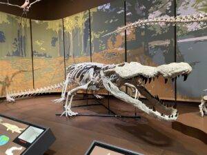
The fossil replica of Deinosuchus schwimmeri on display in the Tellus Science Museum. Credit: Tellus Science Museum

Dr. David Schwimmer, an expert on the giant North American crocodilian genus Deinosuchus and a Columbus State University geology professor, has contributed his research to the creation of the first-ever scholarly accurate, mounted skeleton replica of the species Deinosuchus schwimmeri. Known for decades as a “dinosaur-killer,” Deinosuchus was almost certainly the apex predator of its day.

Deinosuchus schwimmeri, which walked the eastern United States 83 million to 76 million years ago, was a dinosaur-eating, school-bus-sized relative of modern alligators. Measuring up to 31 feet (9.45 meters) long, the new Deinosuchus schwimmeri prototype was commissioned by the Tellus Science Museum in Cartersville, Georgia, and recently installed there. It marks the culmination of two years of Schwimmer’s consulting with Triebold Paleontology Inc., a leader in fossil skeleton models for museums, universities and attractions around the world.

“Each year, we have thousands of students visit us from across Georgia and neighboring states,” the Tellus Science Museum’s director of education, Hannah Eisla, explained. “Many of these students come on school field trips specifically to learn more about the region they call home and how it has changed over time. The addition of Deinosuchus schwimmeri allows us to provide a more detailed picture of this area’s ecosystem in the Cretaceous Period.”

“Tellus is currently the only museum to have a cast of Deinosuchus schwimmeri, so this is an experience our visitors can’t get anywhere else,” added Rebecca Melsheimer, the museum’s curatorial coordinator. “The scale of the dinosaurs and other creatures that lived during [the Late Cretaceous epoch] is hard to capture in words or pictures. We can tell you that Deinosuchus is 30 feet long, but seeing it is far more impactful.”

A group of paleontologists classified the new species of “terror croc” and named it Deinosuchus schwimmeri for Schwimmer in 2020, after years of Schwimmer’s meticulous fossil study, journal publications, conference presentations and a 2002 book on the giant North American Cretaceous crocodilian genus. In their article, published by the Journal of Vertebrate Paleontology in July 2020, they explained that naming it after Schwimmer honored “his tireless work on the Late Cretaceous paleontology of the Southeast and Eastern Seaboard, U.S..”

For more than 40 years, Schwimmer has searched for and excavated fossil evidence of Deinosuchus schwimmeri. The fossil artifacts he’s recovered are now permanently cared for and preserved by leading national “repository” museums, including the Smithsonian Institution in Washington, D.C., the American Museum of Natural History in New York and the Tellus Science Museum.

Creating a science-informed, life-sized fossil replica is a meticulous process, Schwimmer explained. In the case of Deinosuchus schwimmeri, the two-year project involved the Triebold Paleontology team capturing high-resolution 3D scans of Deinosuchus fossil records to rearticulate the creature’s detailed dermal armor and skeletal structure. He pointed out that the newly assembled replica better informs the field of paleontology.

“These replicas are more than just creating a ‘scare factor,'” Schwimmer explained. “Understanding dinosaurs’ predatory habits helps us decode some of nature’s greatest survival strategies. By studying these ancient apex predators, we are essentially looking back in time to see exactly how life adapted and dominated a changing world.”

Research decades in the making

Schwimmer grew up in New York City just 10 blocks from the American Museum of Natural History, and it was there that a terrifying skull display sparked his fascination with Deinosuchus. Since finding his first Deinosuchus fossil remains in 1979—a year after joining Columbus State (then Columbus College)—his research has focused on piecing together the life and environment of this creature.

Today, his research on Deinosuchus has made him a worldwide expert on life in the Late Cretaceous epoch (100.5 million years ago to 66 million years ago) in the Southeast U.S. His research, dating back to the 1980s, led to the discovery of evidence for specific “firsts” in Georgia: flying reptiles (pterodactyls), the first dinosaurs and the first Deinosuchus.

Schwimmer—who once worked as a science writer for pioneering ocean explorer Jacques-Yves Cousteau—detailed the first two decades of his research findings in his popular 2002 book, “King of the Crocodylians: The Paleobiology of Deinosuchus.” It was an Amazon top-seller in its category for several weeks and a popular book-of-the-month selection by science-oriented reading clubs, such as one organized by the Discovery Educator Network.

The book, which Schwimmer is currently updating, has helped shape the understanding of Deinosuchus and other Mesozoic animals in Georgia and garnered him international recognition as a top paleontology scholar. Since then, respected museums like Atlanta’s Fernbank Museum of Natural History, the University of Texas’ Vertebrate Paleontology Laboratory, and the Tellus Museum have sought his expertise on their fossil collections and educational displays.

In 2010, Schwimmer drew international attention for two published fossil studies linked to Deinosuchus: his research on dinosaur-bone bite marks, and research on fossilized dung (coprolites) by 2010 undergraduate environmental science and geology major Samantha (Harrell) Stanford, whom he supervised. Those studies appeared in the special symposium volume of the “New Mexico Museum of Natural History and Science Bulletin,” a publication with an international reputation, and at the March 2010 Geological Society of America Northeastern-Southeastern Annual Meeting. Harrell was cited as contributing to both studies.

Schwimmer pointed out that specialties like paleontology and other natural, Earth and space sciences offer students opportunities to conduct “backyard research” with faculty at regional universities like Columbus State. He said that locally based research opportunities are plentiful for students wishing to get their hands dirty, as well as offering other benefits.”

“[Harrell] came out in the field and collected fossils with me. At most universities, undergraduates rarely collaborate on or publish peer-reviewed research. Institutions of our size provide undergraduate students like Samantha with greater one-on-one access to faculty mentors and field-based research opportunities like this that, while local, are still quite impactful on the field,” Schwimmer said.

With several Deinosuchus sites within 40 miles of Columbus, the area has been a rich bed of discovery for Schwimmer and the student researchers who have tagged along on his expeditions. Schwimmer said that proximity is also what makes the Tellus Science Museum a natural place for one of the first Deinosuchus fossil replicas.

“Bones and fossils tell us only part of the story,” Schwimmer concluded. “Fully assembled, life-size replicas become a blueprint for better understanding the dynamic animals that creatures like Deinosuchus really were.”

Note: The above post is reprinted from materials provided by Columbus State University.

Prehistoric elephant footprints documented for first time in Murcia’s fossil dunes

Mustelipeda aff. punctata Kordos. Credit: Quaternary Science Reviews (2025). DOI: 10.1016/j.quascirev.2025.109631

An international team, involving researchers from the University of Seville, the Andalusian Institute of Earth Sciences in Granada and the University of Huelva, has identified the first fossilized vertebrate footprints from the Quaternary period in fossil dune deposits in Murcia, attributed to the elephant Palaeoloxodon antiquus, known as the straight-tusked elephant.

The study “New vertebrate footprint sites in the latest interglacial dune deposits on the coast of Murcia (southeast Spain). Ecological corridors for elephants in Iberia?” published in the journal Quaternary Science Reviews, reconstructs the movement routes of megafauna during the Last Interglacial, some 125,000 years ago. This record of footprints in coastal landscapes provides remarkable information about Iberian paleoecology.

The research was based on prospecting campaigns on the Murcian coast, in the areas of Calblanque and Torre de Cope, coordinated by Carlos Neto de Carvalho, from the Geology Office of the Municipality of Idanha-a-Nova and the University of Lisbon. The researchers Fernando Muñiz Guinea and Miguel Cortés-Sánchez, from the University of Seville, Francisco J. Jiménez Espejo and Jon Camuera, from IACT-CSIC (Granada), and Luis M. Cáceres, from the University of Huelva, participated in these campaigns. The team was completed by experts from Portugal, such as Noel Moreira (University of Évora) and João Belo (University of Coimbra).

Not only elephants, but also wolves and deer

Thanks to this work, the study has confirmed the existence of four areas with fossil footprints that evidence the presence of a very diverse community of mammals in a coastal forest ecosystem during the marine isotopic stage (MIS 5e) of Earth.

The main finding comes from Torre de Cope, where a 2.75-meter-long proboscidean trackway has been preserved, consisting of four rounded footprints 40–50 cm in diameter. The arrangement, typical of the quadrupedal gait of elephants, has made it possible to estimate that the trackway belonged to an adult Palaeoloxodon antiquus about 2.3 meters tall at the hip, over 30 years old and weighing approximately 2.6 tonnes.

Moreover, traces of a medium-sized mustelid have been found in Calblanque. The trail, one and a half meters long and consisting of ten almost circular footprints arranged in pairs, suggests slow movements near water sources. An isolated footprint of a canid, measuring 10 × 8 cm, with claw marks, has also been found in this area, pointing to the presence of predators such as wolves (Canis lupus) in wooded habitats.

In addition, bifid footprints up to 10 cm in size have been identified as compatible with red deer (Cervus elaphus). Their westward orientation indicates movement through dunes and scrubland. Meanwhile, the trail of a young equid (Equus ferus), with footprints measuring approximately 10 × 12 cm, represents the most recent record of this species in the south-east of the peninsula.

Taken together, these data support the hypothesis of coastal ecological corridors for seasonal migrations, connecting Mediterranean forests with beaches in a more humid landscape.

Coastal corridors and Neanderthal life in the Iberian Pleistocene

The possible megafaunal corridors located on the coast of Murcia open up a broader reflection on the role played by the Iberian Peninsula during the Pleistocene. This territory would have acted as a climate refuge for fauna and flora, as well as serving as a route for large mammals, including elephants.

In this study, the authors establish a connection between these coastal ecological corridors and paleoanthropology, showing a geographical coincidence between the routes followed by elephants in south-eastern Iberia and the sites with Neanderthal presence. These coastal areas would therefore have been rich in resources and key areas for hunting and subsistence for Neanderthal populations.

Reference:
Carlos Neto de Carvalho et al, New vertebrate tracksites from the Last Interglacial dune deposits of coastal Murcia (southeastern Spain): ecological corridors for elephants in Iberia?, Quaternary Science Reviews (2025). DOI: 10.1016/j.quascirev.2025.109631

Note: The above post is reprinted from materials provided by University of Seville.

Metabolic analyses of animal fossils help scientists reconstruct million-year-old environments

Antelope bone fragment in rock from the 3-million-year-old early human site, Makapansgaat (South Africa). Its bone marrow cavity is filled with a white carbonate-rich precipitate. Paleometabolomics can describe the well-being of that animal and provide ultrafine-scale reconstructions of its paleoecology. Credit: Timothy Bromage and Bin Hu, NYU College of Dentistry

For the first time, scientists have analyzed metabolism-related molecules from the fossilized bones of animals that lived 1.3 to 3 million years ago, revealing insights about both the animals and their environments.

The metabolic clues about the animals’ health and diets enabled researchers to paint a picture of their living conditions, including the temperature, soil, rainfall, and vegetation.

Their findings, published in Nature, reveal warmer and wetter conditions across these environments compared to today.

Studying metabolites—the molecules produced and used in digestion and other chemical processes in the body—can provide information about health and disease, as well as external factors like diet and environmental exposures.

While metabolomic research is increasingly used in studying human diseases and drugs, few scientists have explored its use in understanding the prehistoric world. Instead, they largely focus on DNA in fossils, which is primarily used for establishing genetic relationships.

“I’ve always had an interest in metabolism, including the metabolic rate of bone, and wanted to know if it would be possible to apply metabolomics to fossils to study early life. It turns out that bone, including fossilized bone, is filled with metabolites,” said Timothy Bromage, professor of molecular pathobiology at NYU College of Dentistry and affiliated professor in NYU’s Department of Anthropology, who led this study with an international team of researchers.

Measuring metabolites

In recent years, paleontologists learned that collagen—the protein that provides structure to bones, skin, and connective tissues—can be preserved in ancient bones, including those of dinosaurs.

“I thought, if collagen is preserved in a fossil bone, then maybe other biomolecules are protected in the bone microenvironment as well,” said Bromage, who directs the Hard Tissue Research Unit at NYU College of Dentistry.

The surfaces of bones are spongy and surrounded by capillary networks, exchanging oxygen and nutrients between the bloodstream and bones. Bromage suspected that, during the process of bone formation, metabolites carried in the bloodstream enter and become trapped in tiny niches in bone.

To test this idea, the researchers employed mass spectrometry, an analytical technique that converts molecules into ions, to see if they could extract metabolites from bone. Using present-day mouse bones, they identified nearly 2,200 metabolites for analysis. The technology also analyzed proteins to detect collagen in some bone samples.

The researchers then turned to animal fossils from 1.3 million to 3 million years ago, collected for prior paleontological research at sites in Tanzania, Malawi, and South Africa where early humans lived.

Focusing on species with living counterparts near these sites today, they used the same analytical methods on fossilized bone fragments from rodents (mouse, ground squirrel, gerbil), as well as an antelope, pig, and elephant.

The analyses yielded thousands of metabolites, many of which were shared with modern-day animals.

The stories fossils tell

Many of the metabolites the researchers found in the fossilized bones represent normal biological functions, including the metabolism of amino acids, carbohydrates, and vitamins and minerals. Several pointed to genes associated with estrogen, suggesting that some of the animals were female.

Other metabolites revealed the animals’ response to disease. Notably, in the bone of a 1.8-million-year-old ground squirrel from the Olduvai Gorge in Tanzania, the researchers found evidence that the squirrel was infected with a parasitic disease known as sleeping sickness in humans, caused by the Trypanosoma brucei parasite and transmitted by the tsetse fly.

“What we discovered in the bone of the squirrel is a metabolite that is unique to the biology of that parasite, which releases the metabolite into the bloodstream of its host. We also saw the squirrel’s metabolomic anti-inflammatory response, presumably due to the parasite,” said Bromage.

The researchers could also deduce what plants the animals ate. While data on plant metabolites are much more limited than those documented in human and animal health, they identified the metabolites of several regionally specific plants, including forms of aloe and asparagus.

“What that means is that, in the case of the squirrel, it nibbled on aloe and took those metabolites into its own bloodstream,” explained Bromage.

“Because the environmental conditions of aloe are very specific, we now know more about the temperature, rainfall, soil conditions, and tree canopy, essentially reconstructing the squirrel’s environment. We can build a story around each of the animals.”

The reconstructed environments corroborate what other research has found about these settings millions of years ago—for instance, that the Olduvai Gorge Bed in Tanzania was freshwater woodland and grassland, while the Olduvai Gorge Upper Bed was dry woodland and marsh. Across all of the sites studied, the conditions in which the animals lived were wetter and warmer than the regions are today.

“Using metabolic analyses to study fossils may enable us to reconstruct the environment of the prehistoric world with a new level of detail, as though we were field ecologists in a natural environment today,” said Bromage.

Reference:
Timothy Bromage, Palaeometabolomes yield biologic and ecologic profiles at early human sites, Nature (2025). DOI: 10.1038/s41586-025-09843-w.

Note: The above post is reprinted from materials provided by New York University.

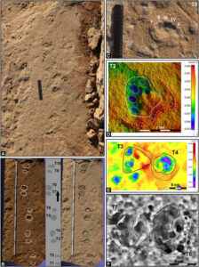
A photographer finds thousands of dinosaur footprints near Italian Winter Olympic venue

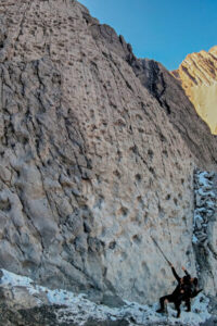
In this photograph taken in September 2025 and released Tuesday, Dec. 16, 2025, by Stelvio National Park, Carabinieri officer Giacomo Regazzoni, left, and park employee Elia Vitalini inspect Late Triassic prosauropod footprints discovered in the Fraele Valley in northern Italy. Credit: Elio Della Ferrara/Stelvio National Park via AP

A wildlife photographer stumbled upon one of the oldest and largest known collections of dinosaur footprints, dating back about 210 million years to the Triassic Period, high in an Italian national park near the 2026 Milan Cortina Winter Olympic venue of Bormio, officials announced Tuesday.

The discovery in the Stelvio National Park was striking for the sheer number of footprints, estimated at as many as 20,000 over some five kilometers (three miles), and the location near the Swiss border, once a prehistoric coastal area, that has never previously yielded dinosaur tracks, experts said.

“This time reality really surpasses fantasy,” said Cristiano Dal Sasso, a paleontologist at Milan’s Natural History Museum, who received the first call from wildlife photographer Elio Della Ferrera after making the discovery.

The dinosaur prints are believed to have been made by long-necked bipedal herbivores that were up to 10 meters (33 feet) long, weighing up to four tons, similar to a Plateosaurus, Dal Sasso said. Some of the tracks were 40 centimeters wide, with visible claws.

The footprints indicated that the dinosaurs traveled in packs and they sometimes stopped in circular formations, possibly as a protective measure.

“There are very obvious traces of individuals that have walked at a slow, calm, quiet rhythmic pace, without running,” Dal Sasso told a press conference.

The tracks were discovered by Della Ferrera, who set out to photograph deer and vultures in September when his camera was trained on a vertical wall about 600 meters (nearly 2,000 feet) above the nearest road.

The location, some 2,400 to 2,800 meters (7,900-9,200 feet) above sea level on a north-facing wall that is mostly in the shade, made the footprints, though in plain sight, particularly hard to spot without a very strong lens, Dal Sasso said.

Della Ferra said something strange caught his eye, and he scaled a vertical rock wall with some difficulty to get a closer look.

“The huge surprise was not so much in discovering the footprints, but in discovering such a huge quantity,” Della Ferrara said. “There are really tens of thousands of prints up there, more or less well-preserved.”

The entrance of the park, where the prints were discovered, is located just two kilometers (a mile) from the mountain town of Bormio, where Men’s Alpine skiing will be held during the Feb. 6-22 Games.

Lombardy regional governor, Attilio Fontana, hailed the discovery as a “gift for the Olympics,” even if the site is too remote to access in the winter, and plans for eventual public access have not been made.

Note: The above post is reprinted from materials provided by The Associated Press. All rights reserved.

Giant sea monsters lived in rivers at the end of the dinosaur age

The Hell Creek Mosasaur. Credit: Christopher DiPiazza

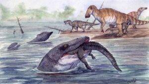
Mosasaurs were enormous marine reptiles that lived more than 66 million years ago, but new evidence shows they did not spend all their time in the ocean. Researchers analyzing a mosasaur tooth discovered in North Dakota have found strong signs that some of these animals lived in rivers. The tooth likely came from an individual that grew up to 11 meters long. Led by scientists at Uppsala University, the international research team concluded that mosasaurs adapted to freshwater river systems during the final million years before their extinction.

The tooth was uncovered in 2022 from a river deposit in North Dakota. It was found alongside a tooth from a Tyrannosaurus rex and a jawbone from a crocodylian, in a region already known for fossils of the duck-billed dinosaur Edmontosaurus. The unusual mix of land dinosaurs, river-dwelling crocodiles, and a giant marine reptile immediately stood out. If mosasaurs were ocean animals, how did one of their teeth end up preserved in a river?

Isotopes Provide the Answer

To solve this puzzle, researchers from the United States, Sweden, and the Netherlands examined the chemical makeup of the mosasaur tooth enamel using isotope analysis.

Because the mosasaur tooth, the T. rex tooth, and the crocodylian jawbone all date to roughly the same time, about 66 million years ago, the scientists could directly compare their chemistry. The work was carried out at the Vrije Universiteit (VU) in Amsterdam and focused on isotopes of oxygen, strontium, and carbon. The mosasaur tooth contained unusually high levels of the lighter oxygen isotope (16O), which is typical of freshwater environments rather than marine ones. Strontium isotope ratios also pointed to a freshwater habitat.

“Carbon isotopes in teeth generally reflect what the animal ate. Many mosasaurs have low 13C values because they dive deep. The mosasaur tooth found with the T. rex tooth, on the other hand, has a higher 13C value than all known mosasaurs, dinosaurs and crocodiles, suggesting that it did not dive deep and may sometimes have fed on drowned dinosaurs,” says Melanie During, one of the study’s corresponding authors.

“The isotope signatures indicated that this mosasaur had inhabited this freshwater riverine environment. When we looked at two additional mosasaur teeth found at nearby, slightly older, sites in North Dakota, we saw similar freshwater signatures. These analyses shows that mosasaurs lived in riverine environments in the final million years before going extinct,” says During.

When Seas Slowly Turned Into Rivers

The findings also help explain how this lifestyle shift became possible. Over time, increasing amounts of freshwater flowed into the Western Interior Seaway, a vast inland sea that once ran north to south across what is now central North America and split the continent in two. As freshwater input grew, the seaway gradually changed from salty to brackish and eventually to mostly freshwater, similar to conditions seen today in the Gulf of Bothnia. The researchers suggest this process created a ‘halocline’, with lighter freshwater forming a surface layer above denser saltwater. Isotope data supports this idea.

“For comparison with the mosasaur teeth, we also measured fossils from other marine animals and found a clear difference. All gill-breathing animals had isotope signatures linking them to brackish or salty water, while all lung-breathing animals lacked such signatures. This shows that mosasaurs, which needed to come to the surface to breathe, inhabited the upper freshwater layer and not the lower layer where the water was more saline,” says Per Ahlberg, coauthor of the study and promotor of Dr. During.

Adapting to a Changing World

The researchers argue that the teeth studied clearly belonged to mosasaurs that had adjusted to these new conditions. Large predators shifting between habitats is not unheard of in evolutionary history.

“Unlike the complex adaptation required to move from freshwater to marine habitats, the reverse adaptation is generally simpler,” says During.

Modern animals show similar flexibility. River dolphins live entirely in freshwater even though their ancestors were marine. The estuarine crocodile, known in Australia as the saltwater crocodile, regularly moves between rivers and the open ocean, hunting wherever prey is available.

A Bus-Sized Predator in Unexpected Places

Mosasaur fossils are common in marine deposits across North America, Europe, and Africa dating from 98-66 million years ago. In contrast, they are rarely found in North Dakota, making this discovery especially striking. The size of the tooth suggests an animal up to 11 meters long, roughly the length of a bus. Earlier discoveries of mosasaur bones at a nearby site support this estimate. The tooth likely belonged to a prognathodontine mosasaur, although its exact genus cannot be identified. Close relatives in the genus Prognathodon had massive heads, powerful jaws, and robust teeth, and are thought to have been opportunistic predators capable of attacking large prey.

“The size means that the animal would rival the largest killer whales, making it an extraordinary predator to encounter in riverine environments not previously associated with such giant marine reptiles,” says Ahlberg.

The research was carried out by scientists from Uppsala University in collaboration with Eastern West Virginia Community and Technical College, Moorefield, West Virginia, Vrije Universiteit Amsterdam, and the North Dakota Geological Survey. The article draws on a chapter from Melanie During’s doctoral thesis, which she defended at Uppsala University in November 2024.

Reference:
Melanie A. D. During, Nathan E. Van Vranken, Clint A. Boyd, Per E. Ahlberg, Suzan J. A. Warmerdam-Verdegaal, Jeroen H. J. L. Van der Lubbe. “King of the Riverside”, a multi-proxy approach offers a new perspective on mosasaurs before their extinction. BMC Zoology, 2025; 10 (1) DOI: 10.1186/s40850-025-00246-y

Note: The above post is reprinted from materials provided by Uppsala University.

Fossil brain scans show pterosaurs evolved flight in a flash

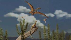
Reconstruction of a Late Triassic landscape (approximately 215 million years ago). A lagerpetid, a close relative of pterosaurs, is perched on a rock, observing pterosaurs flying overhead. Credit: Matheus Fernandes, edited

A research group led by an evolutionary biologist at Johns Hopkins Medicine reports that giant reptiles living as far back as 220 million years ago may have developed the ability to fly at the very start of their evolutionary history. This contrasts with the ancestors of modern birds, which are thought to have reached powered flight more slowly and with larger, more complex brains.

Details of the investigation, which relied on advanced imaging methods to examine the internal brain cavities of pterosaur fossils and received partial support from the National Science Foundation, appeared Nov. 26 in Current Biology.

According to Matteo Fabbri, Ph.D., assistant professor of functional anatomy and evolution at the Johns Hopkins University School of Medicine, the results strengthen the idea that the enlarged brains seen in birds and likely in their ancestors were not responsible for allowing pterosaurs to take to the air.

“Our study shows that pterosaurs evolved flight early on in their existence and that they did so with a smaller brain similar to true non-flying dinosaurs,” Fabbri says.

Giant Fliers With Surprising Brain Structure

Fabbri describes pterosaurs as powerful airborne predators of the dinosaur era, capable of reaching 500 pounds in some species and stretching up to 30 feet across the wings. Pterosaurs are recognized as the earliest of the three major vertebrate lineages (in addition to birds and bats) that eventually achieved powered flight on their own.

To investigate how pterosaurs gained this ability and whether their path differed from that of birds and bats, the team examined the reptile’s evolutionary history. They looked closely at shifts in the shape and size of the brain over time and focused on the optic lobe, the region involved in vision that has been linked to flight capabilities.

CT Scans Reveal Clues From Early Relatives

Using CT imaging and specialized software that allowed them to digitally model fossilized nervous system structures, the researchers concentrated on the closest known relative of the pterosaur. This animal, the flightless and tree-climbing lagerpetid, was first identified by scientists in 2016 and lived during the Triassic period between 242 and 212 million years ago. In 2020, another team confirmed the lagerpetid’s close evolutionary connection to pterosaurs.

“The lagerpetid’s brain already showed features linked to improved vision, including an enlarged optic lobe, an adaptation that may have later helped their pterosaur relatives take to the skies,” says corresponding author Mario Bronzati, a researcher at University of Tübingen, Germany.

Fabbri notes that pterosaurs also had enlarged optic lobes. Outside of this trait, however, he explains that their brain shape and size differed considerably from those of the lagerpetid.

“The few similarities suggest that flying pterosaurs, which appeared very soon after the lagerpetid, likely acquired flight in a burst at their origin,” Fabbri says. “Essentially, pterosaur brains quickly transformed acquiring all they needed to take flight from the beginning.”

Comparing Pterosaur and Bird Flight

In contrast, modern birds are thought to have evolved flight through a more gradual process. They appear to have inherited several key traits, including expansion of the cerebrum, cerebellum and optic lobes, from earlier relatives before further adapting these regions for flight, Fabbri says. Support for this gradual model comes from 2024 research from the laboratory of Amy Balanoff, Ph.D., assistant professor of functional anatomy and evolution at Johns Hopkins Medicine, which highlights the importance of cerebellum expansion in the origins of bird flight. The cerebellum is located at the back of the brain and helps regulate muscle coordination and other functions.

“Any information that can fill in the gaps of what we don’t know about dinosaur and bird brains is important in understanding flight and neurosensory evolution within pterosaur and bird lineages,” Balanoff says.

Insights From Fossilized Brains Across Species

The team also examined brain cavities from crococdylians (crocodile ancestors) and early, extinct birds, comparing these structures with those of pterosaurs.

Their analysis showed that pterosaurs had moderately enlarged brain hemispheres, a feature comparable to other dinosaur groups. These include two-legged, bird-like troodontids that lived between the Late Jurassic and Late Cretaceous periods from 163 to 66 million years ago, as well as Archaeopteryx lithographica, the oldest-known bird that lived between 150.8 and 125.45 million years ago. These prehistoric species differ strongly from modern birds, which have significantly larger brain cavities.

Looking Ahead to Future Research

Fabbri says that future progress will depend on understanding how the brain’s internal structure, not just its size and shape, enabled pterosaurs to achieve flight. He explains that this will be essential for uncovering the broader biological principles that govern the evolution of flight.

Funding support for this research was provided by the Alexander von Humboldt Foundation, Brazilian Federal Government, The Paleontological Society, Agencia Nacional de Promoción Científica y Técnica, Conselho Nacional de Desenvolvimento Científico e Tecnológico, the European Union NextGeneration EU/PRTR, the National Science Foundation ( NSF DEB 1754596, NSF IOB-0517257, IOS-1050154, IOS-1456503), and the Swedish Research Council

In addition to Fabbri and Bronzati, other scientists who contributed to this research are Akinobu Watanabe from New York Institute of Technology, Roger Benson from the American Museum of Natural History, Rodrigo Müller from Federal University of Santa Maria, Brazil, Lawrence Witmer from the University of Ohio, Martín Ezcurra and M. Belén von Baczko from Bernardino Rivadavia Museum of Natural Science, Felipe Montefeltro from São Paulo State University; Bhart-Anjan Bhullar from Yale University; Julia Desojo from Universidad Nacional de La Plata, Argentina; Fabien Knoll from Museo Nacional de Ciencias Naturales, Spain; Max Langer from Universidade de São Paulo, Brazil; Stephan Lautenschlager from University of Birmingham; Michelle Stocker and Sterling Nesbitt from from Virginia Tech; Alan Turner from Stony Brook University; and Ingmar Werneburg from Eberhard Karls University of Tübingen.

Reference:
Mario Bronzati, Akinobu Watanabe, Roger B.J. Benson, Rodrigo T. Müller, Lawrence M. Witmer, Martín D. Ezcurra, Felipe C. Montefeltro, M. Belén von Baczko, Bhart-Anjan S. Bhullar, Julia B. Desojo, Fabien Knoll, Max C. Langer, Stephan Lautenschlager, Michelle R. Stocker, Alan H. Turner, Ingmar Werneburg, Sterling J. Nesbitt, Matteo Fabbri. Neuroanatomical convergence between pterosaurs and non-avian paravians in the evolution of flight. Current Biology, 2025; DOI: 10.1016/j.cub.2025.10.086

Note: The above post is reprinted from materials provided by Johns Hopkins Medicine.

This rare bone finally settles the Nanotyrannus mystery

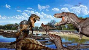
A Late Cretaceous face-off between an adult Nanotyrannus (left) and two juvenile T. rex, with a sub-adult T. rex watching from a distance. The scene evokes a preface to the NHMLAC’s famous T. rex trio on display in the Jane G. Pisano Dinosaur Hall. Credit: Jorge Gonzalez

For many years, paleontologists have debated whether the single skull used to define the species Nanotyrannus represented a true species or simply a young Tyrannosaurus rex. A new study in Science has now resolved this question. The research shows that Nanotyrannus was nearly fully grown and not a juvenile T. rex, while also offering new clues about how large tyrannosaur species achieved rapid growth.

A collaborative team that included Dinosaur Institute Postdoctoral Fellow Dr. Zach Morris studied the disputed Nanotyrannus holotype — the specimen originally used to identify the species — with a close focus on its throat bone. By investigating the microscopic details of this bone and comparing them with those of modern birds, crocodilians, and other dinosaurs — including specimens from the Dino Hall’s T. rex growth series — the group confirmed that Nanotyrannus was a mature and separate predator. Although smaller than an adult T. rex, it was still a full-grown animal that lived in a far more diverse Late Cretaceous ecosystem than previously thought. Measuring under half the size of an adult T. rex, Nanotyrannus likely competed with young T. rex individuals for the same prey.

“The identity of the holotype specimen was the key piece in this debate. Discovering that this small skull was actually fully grown shows definitively that it is different from Tyrannosaurus rex,” said Dr. Christopher Griffin, lead author and Assistant Professor of Geosciences at Princeton University.

How Bone Structure Reveals Age and Growth

Just as tree rings can indicate a tree’s age, thin slices taken from dinosaur bones can reveal how old an animal was and how quickly it grew. Scientists study microscopic tissue patterns within these bone samples to determine maturity. Long bones such as ribs or femora are typically used, but they are not always preserved. In the case of Nanotyrannus, most of the holotype consists of skull material filled with sinuses and other irregular features that make it unsuitable for this type of study. The hyoid, however — the throat bone that supports the tongue — offered a rare opportunity to assess maturity in a skull-dominated specimen.

“When we started this project, it was unclear whether the hyoid preserved a record of a dinosaur’s growth. To be honest, we mostly accepted the hypothesis that Nanotyrannus was a juvenile T. rex, so we expected the microscopic bone structure or histology of the holotype would show this animal was still growing quickly,” said co-author Dr. Morris. “What we did not expect was to see it was nearing maturity with clear evidence of the cessation of growth!”

Testing the Throat Bone as a New Tool for Dinosaur Aging

Because no one had previously proven that hyoid bones could reliably preserve growth information, the researchers needed to verify the method before applying it to Nanotyrannus. To do so, Dr. Griffin assembled a team to create a broad comparative dataset of hyoid samples from living lizards, crocodiles, birds, and extinct dinosaurs. “To show that hyoid microstructure would work to test maturity status in Nanotyrannus, we first had to compile strong support for this method across many groups of living reptiles and extinct dinosaurs,” said Dr. Griffin.

Dr. Morris led the work on the juvenile and sub-adult specimens known as “Thomas” from NHM’s rare T. rex growth series. “The growth series in our Dino Hall was critical to demonstrating that the hyoid in Tyrannosaurus showed the same kind of growth record as long bones,” Morris explained. “Having a growth series that had already been histologically analyzed meant that we could compare the growth record in the hyoid and the growth record in the long bones and see that they show consistent signals even in these uniquely giant predators.” This comparison allowed the researchers to set clear benchmarks for distinguishing growth differences between T. rex and Nanotyrannus.

“Our teenage Tyrannosaurus looks immature in both its limbs and its hyoid, while Thomas looks like a more mature, but still not quite adult animal. Amusingly enough, Thomas is not nearly as mature as the Nanotyrannus holotype, despite being much larger,” added Morris.

Balancing Conservation, Discovery, and Scientific Accuracy

The findings emphasize how important it is for paleontologists to understand the maturity of holotype specimens. Without this knowledge, scientists risk mistaking growth-related changes for evolutionary ones. “So many techniques in modern paleontology require some degree of destructive analysis, and as a Curator, I’m always trying to strike a balance between conservation and discovery. We preserved the anatomical data by 3D scanning and molding and casting the hyoid, and there is still more of it for future analyses,” said senior author Dr. Caitlin Colleary of the Cleveland Museum of Natural History (and incidentally, a former undergraduate volunteer in the NHM Dinosaur Institute). “In this instance, it was totally worth it because we gained so much more than we lost.”

The new evidence also reshapes the view of Late Cretaceous North America. Instead of T. rex ruling alone before the end-Cretaceous mass extinction, the region appears to have hosted multiple tyrannosaur species at the same time. “It is remarkable that our study matches findings from other independent lines of evidence, including an analysis published last month, demonstrating that multiple species of tyrannosaurs lived alongside one another. It shows that we need to re-evaluate what we think these ecosystems looked like,” said Dr. Morris.

Expanding Knowledge Through Museum Collections and Collaborative Research

Dr. Morris serves as the first Dinosaur Institute Postdoctoral Fellow, focusing on how developmental processes shape evolutionary changes and how skull anatomy shifts over time in the fossil record. “I am fascinated by the ways in which changes during development give rise to the skeletal features which distinguish dinosaurs, birds, crocodylians, and other vertebrates,” said Morris. “This project was an exciting collaboration to study developmental patterns in the fossil record directly.”

“Zach’s expertise in dinosaur growth and development, coupled with his histological skills, was a huge asset to this project. It’s another example of our NHMLAC Post-Docs conducting novel, ground-breaking research,” said Dr. Nate Smith, Gretchen Augustyn Director & Curator of the Dinosaur Institute. “This study also highlights the incredible potential of unique museum collections like our T. rex growth series, which not only inform the public but also provide rich ground for new scientific discoveries.”

Reference:
Christopher T. Griffin, Jeb Bugos, Ashley W. Poust, Zachary S. Morris, Riley S. Sombathy, Michael D. D’Emic, Patrick M. O’Connor, Holger Petermann, Matteo Fabbri, Caitlin Colleary. A diminutive tyrannosaur lived alongside Tyrannosaurus rex. Science, 2025; DOI: 10.1126/science.adx8706

Note: The above post is reprinted from materials provided by Natural History Museum of Los Angeles County.

Dinosaur bones found almost on top of each other in Transylvania

The bones were lying almost on top of each other in the layer. Credit: ELTE Eötvös Loránd University

The Hațeg Basin in Transylvania has long been known around the world for its dinosaur fossils, uncovered at dozens of sites over the last hundred years. Even so, complete dinosaur discoveries are usually uncommon across the region. That pattern changed with the identification of a newly studied site where scientists documented more than 100 vertebrate fossils per square meter, including large dinosaur bones lying almost directly on top of one another.

Years of Fieldwork Lead to an Exceptional Fossil Find

For more than five years, the Valiora Dinosaur Research Group, made up of Hungarian and Romanian paleontologists, has been carrying out fieldwork in the western Hațeg Basin. The rocks examined there date back to the Upper Cretaceous and capture the final few million years before dinosaurs disappeared. Excavations have revealed fossil-rich deposits containing thousands of remains from amphibians, turtles, crocodiles, dinosaurs, pterosaurs, and mammals.

Among all the sites explored, one location known as K2 stands out. From an area measuring less than five square meters, researchers recovered more than 800 vertebrate fossils, making it the richest site documented so far. The full scientific analysis of this discovery was recently published in the journal PLOS ONE.

A Defining Moment in the Field

“In 2019, during our first field survey in the Hațeg Basin, we almost immediately came across the K2 site. It was a defining moment for us — we instantly noticed dozens of large, exceptionally well-preserved black dinosaur bones gleaming in the grey clay layers exposed in the streambed. We immediately began our work, and through several years of excavation we collected an extraordinarily rich vertebrate assemblage from the site,” explained Gábor Botfalvai, assistant professor at the Department of Paleontology, Eötvös Loránd University, and leader of the research group.

How Ancient Floods Created a Bone-Rich Landscape

About 72 million years ago, the region that is now the Hațeg Basin experienced a warm, subtropical climate shaped by temporary river systems. These rivers flowed from higher terrain toward the basin and frequently spilled over their banks during heavy rainfall. As floodwaters surged downstream, they gathered animal carcasses from the surface, along with living creatures and skeletal remains caught in their path.

“Detailed study of the rocks at the K2 site indicates that a small lake once existed here, which was periodically fed by flash floods carrying animal carcasses. As the flow of the rivers slowed rapidly upon entering the lake, the transported bodies accumulated in the deltaic environment along the shore, producing this exceptionally high bone concentration,” said Soma Budai, researcher at the University of Pavia and co-author of the publication.

Rare Dinosaur Skeletons Reveal New Scientific Insights

The K2 site produced far more than scattered bones. Researchers also identified several partial dinosaur skeletons that remained associated with one another. These fossils represent two separate plant-eating dinosaur species. One group belongs to a roughly two-meter-long dinosaur from the Rhabdodontidae family, a species commonly found in the Hațeg Basin that likely moved mainly on two legs.

The second group of skeletons marks a major breakthrough. These remains belong to a titanosaurian sauropod, a long-necked dinosaur for which no comparably well-preserved skeletons had ever been discovered in Transylvania. Ongoing analysis of these fossils is expected to improve scientists’ understanding of how this dinosaur fits into the broader evolutionary family tree.

The Oldest Known Vertebrate Accumulation in the Basin

“Besides the remarkably high bone concentration, another key significance of this newly described site is that it represents the oldest known vertebrate accumulation in the Hațeg Basin. Studying this fossil assemblage allows us to look into the earliest composition of the Hațeg dinosaur fauna and trace the evolutionary directions and processes leading toward the dinosaurs known from younger Transylvanian sites — revealing how these Late Cretaceous ecosystems were similar or different from one another,” added Zoltán Csiki-Sava, associate professor at the University of Bucharest and Romanian leader of the research team.

Reconstructing Dinosaur Life in Ancient Europe

The fossils described in this study, together with discoveries still emerging from ongoing excavations in the Hațeg Basin, are helping scientists refine their understanding of how dinosaur communities evolved across (Eastern) Europe during the Late Cretaceous. These finds provide valuable clues about how ancient ecosystems formed, changed, and responded to environmental forces near the end of the age of dinosaurs.

The research was supported by the National Research, Development and Innovation Office of Hungary (NKFIH), the Supervisory Authority for Regulatory Affairs of Hungary, the Romanian Ministry of Research, Innovation and Digitalization, and the University of Bucharest.

Reference:
Gábor Botfalvai, Zoltán Csiki-Sava, János Magyar, Barna Páll-Gergely, Levente Koczó, Daniel Ţabără, Gergő Konecsni, Soma Budai. Paleontological and paleoecological significance of the oldest highly productive Upper Cretaceous (lowermost Maastrichtian) bonebed of Haţeg Basin (western Romania; Densuş-Ciula Formation). PLOS One, 2025; 20 (11): e0335893 DOI: 10.1371/journal.pone.0335893

Note: The above post is reprinted from materials provided by Eötvös Loránd University.

Scientists found a hidden clock inside dinosaur eggshells

Artistic reconstruction of a newly hatched troodontid-like dinosaur resting among fragments of its eggshell (loosely based on Mongolian microtroodontid-type). These eggshells, when buried within ancient soil, interacted with meteoric waters, leading to early uranium incorporation into the eggshell calcite crystals. Credit: Eva Utsukiyouhei (宇津城遥平)

A global team of geologists and paleontologists has developed a new technique that makes it possible to accurately determine the age of fossil-bearing rocks by directly analyzing fossilized dinosaur eggshells. This approach offers a reliable alternative to methods that depend on surrounding materials that may not always be present.

The research was led by Dr. Ryan Tucker of Stellenbosch University’s Department of Earth Sciences and published in the journal Communications Earth & Environment.

Why Fossil Dating Has Been So Difficult

Many fossil sites around the world lack precise age estimates. When scientists do not know exactly when fossils formed, it becomes much harder to understand how ancient species and ecosystems evolved and interacted over time. Traditional dating methods usually rely on minerals like zircon or apatite found near fossils, but these minerals are not consistently available at every site. Efforts to directly date fossil remains such as bones or teeth have often resulted in unreliable or inconsistent ages.

Instead of focusing on surrounding minerals or skeletal remains, Dr. Tucker and his colleagues turned their attention to fossilized dinosaur eggshells. Using advanced uranium-lead (U-Pb) dating combined with detailed elemental mapping, the team measured extremely small amounts of uranium and lead locked inside the calcite structure of the eggshells. These radioactive elements decay at known rates, effectively acting as a built-in clock that reveals when the eggs were buried.

Testing the Method in Utah and Mongolia

The researchers tested their approach on dinosaur eggshells from Utah (USA) and the Gobi Desert (Mongolia). The results showed that the eggshells could be dated with an accuracy of about five percent when compared with ages determined from volcanic ash layers. In Mongolia, the team achieved a major milestone by establishing the first direct age for a famous site containing dinosaur eggs and nests, placing it at roughly 75 million years old.

“Eggshell calcite is remarkably versatile,” says Dr. Tucker. “It gives us a new way to date fossil sites where volcanic layers are missing, a challenge that has limited paleontology for decades.”

The project brought together scientists from the North Carolina Museum of Natural Sciences, North Carolina State University, Colorado School of Mines, the Mongolian Academy of Sciences’ Institute of Paleontology, and Universidade Federal de Ouro Preto (Brazil). Fieldwork in Mongolia was conducted through the Mongolian Alliance for Dinosaur Exploration (MADEx), with support from the National Geographic Society and the National Science Foundation.

A Powerful Tool for Understanding Dinosaur Evolution

By demonstrating that dinosaur eggshells can reliably record geologic time, the study creates a new connection between biology and Earth science and provides researchers with a valuable tool for dating fossil sites worldwide.

“Direct dating of fossils is a paleontologist’s dream,” says study co-author Lindsay Zanno, associate research professor at North Carolina State University and head of paleontology at the North Carolina Museum of Natural Sciences. “Armed with this new technique, we can unravel mysteries about dinosaur evolution that used to be insurmountable.”

The article “U-Pb calcite age dating of fossil eggshell as an accurate deep time geochronometer” was published in Communications Earth & Environment.

Reference:
Ryan T. Tucker, Kira E. Venter, Cristiano Lana, Eric M. Roberts, Tsogtbaatar Chinzorig, Khishigjav Tsogtbaatar, Lindsay E. Zanno. U-Pb calcite age dating of fossil eggshell as an accurate deep time geochronometer. Communications Earth, 2025; 6 (1) DOI: 10.1038/s43247-025-02895-w

Note: The above post is reprinted from materials provided by Stellenbosch University.

Ancient oceans were ruled by super predators unlike anything today

Image by Artwork by Guillermo Torres, Hace Tiempo, Instituto von Humboldt. Illustration of some of the apex predators in the Paja Formation biota with a human for scale.

Around 130 million years ago, the ocean’s most dominant hunters held far more power than any marine predator alive today. Recent research from McGill University reveals that during the Cretaceous period, some sea creatures sat at the very top of an extraordinarily complex food chain, surpassing modern standards of ecological dominance.

The findings come from a study published in the Zoological Journal of the Linnean Society, which reconstructs the ancient marine ecosystem preserved in Colombia’s Paja Formation. According to the research, this prehistoric sea was filled with enormous marine reptiles, some growing longer than 10 meters, that occupied a previously unseen seventh level of the food chain.

What Trophic Levels Reveal About Food Chains

Trophic levels describe an organism’s position in a food chain based on how it gets energy and nutrients. Put simply, they explain who eats whom within an ecosystem. In today’s oceans, food chains typically reach only six levels, with animals such as killer whales and great white sharks sitting at the top.

The discovery of predators operating at a seventh trophic level highlights just how rich and complex the Paja ecosystem once was. It also offers rare insight into a deep evolutionary struggle, where predators and prey continuously adapted in response to one another.

Reconstructing a Lost Marine Ecosystem

To uncover this ancient food web, McGill researchers analyzed all known animal fossils from a single geological formation in central Colombia. They built a detailed ecological network using fossil body sizes, feeding traits, and comparisons with modern animals that fill similar roles today.

To ensure accuracy, the team compared their reconstructed network with one of the most comprehensive modern marine ecosystem models available, based on living Caribbean environments. This allowed them to test whether their ancient model behaved realistically when measured against present-day ocean systems.

A Time of Explosive Marine Diversity

The Paja Formation dates back to the Mesozoic era, a time that included the Cretaceous period and was shaped by rising sea levels and warmer global temperatures. These conditions fueled a surge in marine biodiversity. The region supported plesiosaurs, ichthyosaurs, and large numbers of invertebrates, creating one of the most intricate marine food webs ever identified.

“Our study is the first to examine these possible ecological interactions,” said Dirley Cortés, lead author and doctoral student in the Department of Biology. “Understanding this complexity helps us trace how ecosystems evolve over time, shedding light on the structures that support today’s biodiversity.”

“These findings illuminate how marine ecosystems developed through intense trophic competition and shaped the diversity we see today,” added Hans Larsson, co-author of the study and Professor in the Department of Biology.

Why This Discovery Matters

The researchers note that this work marks only an early step in understanding ancient marine ecosystems. Very few fossil sites have been studied in enough detail to rebuild entire food webs. As more discoveries emerge, scientists will be able to compare ecosystems across different regions and time periods, deepening knowledge of how ancient oceans influenced the modern seas we depend on today.

“Top of the food chains: an ecological network of the marine Paja Formation biota from the Early Cretaceous of Colombia reveals the highest trophic levels ever estimated” by Dirley Cortés and Hans Larsson, was published in the Zoological Journal of the Linnean Society.

The research was supported by funding from the McGill-STRI Neotropical Environment Option (NEO) and the Natural Sciences and Engineering Research Council of Canada (NSERC).

Reference:
Dirley Cortés, Hans C E Larsson. Top of the food chains: an ecological network of the marine Paja Formation biota from the Early Cretaceous of Colombia reveals the highest trophic levels ever estimated. Zoological Journal of the Linnean Society, 2024; 202 (1) DOI: 10.1093/zoolinnean/zlad092

Note: The above post is reprinted from materials provided by McGill University.

1.5-million-year-old fossil face is forcing a rethink of human origins

Map showing potential migration routes of the human ancestor, Homo erectus, in Africa, Europe, and Asia during the early Pleistocene. Key fossils of Homo erectus and the earlier Homo habilis species are shown, including the new face reconstruction of the DAN5 fossil from Gona, Ethiopia dated to 1.5 million years ago. Credit: Dr. Karen L. Baab. Scans provided by National Museum of Ethiopia, National Museums of Kenya and Georgian National Museum

An international research team led by Dr. Karen Baab, a paleoanthropologist at the College of Graduate Studies, Glendale Campus of Midwestern University in Arizona, created a digital reconstruction of the face of early Homo erectus. The fossil, known as DAN5, is dated to about 1.5 to 1.6 million years old and was discovered at Gona in Ethiopia’s Afar region. The rebuilt face looks more archaic than many scientists expected, offering fresh clues about one of the first human species to expand across Africa and Eurasia. The results were published in Nature Communications.

Dr. Baab says the reconstruction adds a surprising new twist: “We already knew that the DAN5 fossil had a small brain, but this new reconstruction shows that the face is also more primitive than classic African Homo erectus of the same antiquity. One explanation is that the Gona population retained the anatomy of the population that originally migrated out of Africa approximately 300,000 years earlier.”

Gona’s Deep Record of Fossils and Stone Tools

The Gona Paleoanthropological Research Project in Ethiopia’s Afar region is co-directed by Dr. Sileshi Semaw (Centro Nacional de Investigación sobre la Evolución Humana, Spain) and Dr. Michael Rogers (Southern Connecticut State University). The Gona area has produced hominin fossils older than 6.3 million years ago, along with stone tools covering the past 2.6 million years of human evolution.

For this reconstruction, scientists combined a fossil brain case (previously described in 2020) with smaller facial fragments from the same individual, DAN5, dated to between 1.6 and 1.5 million years ago. Using virtual methods, the team reassembled the face fragments (and teeth) to build what they describe as the most complete fossil human skull from the Horn of Africa for this time period. Researchers classify DAN5 as Homo erectus, a long-lasting species found across Africa, Asia, and Europe after about 1.8 million years ago.

How Micro-CT Scans Rebuilt the DAN5 Skull

To piece the fossil together, the team used high-resolution micro-CT scans of four major facial fragments recovered during fieldwork at Gona in 2000. They built 3D digital models from those scans, then carefully aligned and reassembled the fragments on a computer. Where possible, they positioned the teeth into the upper jaw. The final stage involved “attaching” the reconstructed face to the braincase to create a mostly complete cranium. The process took about a year and required multiple rounds of refinement before the team settled on the final reconstruction.

Dr. Baab, who led the reconstruction work, compared it to “a very complicated 3D puzzle, and one where you do not know the exact outcome in advance. Fortunately, we do know how faces fit together in general, so we were not starting from scratch.”

A Mix of Homo erectus Traits and Older Features

The study suggests that the Gona population living around 1.5 million years ago combined traits typically associated with Homo erectus in the braincase with more ancestral features in the face and teeth that are usually linked to earlier species. The researchers point to examples such as a relatively flat bridge of the nose and large molars.

To reach these conclusions, the team compared the size and shape of the DAN5 face and teeth with fossils from the same geological age, as well as specimens that are older and younger. A similar trait combination has been reported before in Eurasia, but DAN5 is described as the first fossil showing this pattern within Africa. That finding challenges the idea that Homo erectus evolved outside Africa. “I’ll never forget the shock I felt when Dr. Baab first showed me the reconstructed face and jaw,” says Dr. Yousuke Kaifu of the University of Tokyo, a co-author of the study.

Dr. Baab argues the broader fossil record still points toward an African origin for the species: “The oldest fossils belonging to Homo erectus are from Africa, and the new fossil reconstruction shows that transitional fossils also existed there, so it makes sense that this species emerged on the African continent. But the DAN5 fossil postdates the initial exit from Africa, so other interpretations are possible.”

Dr. Rogers agrees that the new skull highlights how varied early humans could be. “This newly reconstructed cranium further emphasizes the anatomical diversity seen in early members of our genus, which is only likely to increase with future discoveries.”

Dr. Semaw adds that the fossil is also notable for its archaeological context: “It is remarkable that the DAN5 Homo erectus was making both simple Oldowan stone tools and early Acheulian handaxes, among the earliest evidence for the two stone tool traditions to be found directly associated with a hominin fossil.”

What Comes Next for DAN5 and Early European Fossils

Next, the researchers want to compare DAN5 with some of the earliest known human fossils from Europe. These include remains assigned to Homo erectus as well as Homo antecessor, a distinct species, with both dated to around one million years ago. “Comparing DAN5 to these fossils will not only deepen our understanding of facial variability within Homo erectus but also shed light on how the species adapted and evolved,” says study co-author Dr. Sarah Freidline of the University of Central Florida.

The team also hopes future discoveries will help test other possibilities, including scenarios involving genetic admixture between species, similar to what has been documented much later among Neanderthals, modern humans and “Denisovans.” One idea is that DAN5 could reflect admixture between classic African Homo erectus and the earlier Homo habilis species. As Dr. Rogers puts it, “We’re going to need several more fossils dated between one to two million years ago to sort this out.”

Reference:
Karen L. Baab, Yousuke Kaifu, Sarah E. Freidline, Michael J. Rogers, Sileshi Semaw. New reconstruction of DAN5 cranium (Gona, Ethiopia) supports complex emergence of Homo erectus. Nature Communications, 2025; 16 (1) DOI: 10.1038/s41467-025-66381-9

Note: The above post is reprinted from materials provided by Midwestern University.

New fossils in Qatar reveal a tiny sea cow hidden for 21 million years

 An illustration of ancient sea cows Alex Boersma
An illustration of ancient sea cows Alex Boersma

Today the Arabian Gulf supports large numbers of dugongs, marine mammals related to manatees that feed on seagrass and leave trails in the sediment as they graze. Newly examined fossils from Qatar show that sea cows living more than 20 million years ago shaped their environments in much the same way.

The findings, published December 10 in the journal PeerJ, come from a partnership between scientists at the Smithsonian’s National Museum of Natural History and Qatar Museums. The team also identified a previously unknown species of ancient sea cow that was much smaller than modern dugongs.

“We discovered a distant relative of dugongs in rocks less than 10 miles away from a bay with seagrass meadows that make up their prime habitat today,” said Nicholas Pyenson, curator of fossil marine mammals at the National Museum of Natural History and a lead author of the study. “This part of the world has been prime sea cow habitat for the past 21 million years — it’s just that the sea cow role has been occupied by different species over time.”

Modern Dugong Biology and Behavior

Dugongs (Dugong dugon) have a stout body and a downward-facing snout lined with bristles that help them sense food, giving them a broad resemblance to manatees. Their tails distinguish them from their relatives. Manatees have a rounded, paddle-shaped tail while dugongs have a dolphin-like tail with flukes (however, dugongs and manatees are more closely related to elephants than they are to dolphins, whales and porpoises).

These herbivores occupy shallow coastal habitats across a wide range that includes western Africa, the Indo-Pacific, and northern Australia. The largest single herd of dugongs occurs in the Arabian Gulf, where their constant grazing stirs up sediment and releases nutrients that benefit surrounding marine ecosystems.

A Long Fossil History and Growing Modern Threats

Fossil evidence shows that sea cow ancestors have fed on aquatic plants for roughly 50 million years. Despite this long history, dugongs in the Gulf now face significant challenges. They are sometimes caught accidentally by local fishers, and development along the coast affects the waters where they feed. Rising temperatures and increasing salinity place further pressures on the seagrass meadows that dugongs depend on.

Ferhan Sakal, head of excavation and site management at Qatar Museums and a coauthor of the study, noted that crucial information about past seagrass environments is preserved in the region’s rock record.

“If we can learn from past records how the seagrass communities survived climate stress or other major disturbances like sea-level changes and salinity shifts, we might set goals for a better future of the Arabian Gulf,” he said.

Researchers rely heavily on fossilized bones to understand these environments, since the soft blades of seagrass rarely leave impressions in the geologic record.

Exploring the Al Maszhabiya Fossil Site

One of the most significant sources of these fossils is Al Maszhabiya [AL mahz-HA-bee-yah], a site in southwestern Qatar. Geologists first encountered the site in the 1970s while conducting mining and petroleum surveys and believed they had found reptile bones. When paleontologists revisited the area in the early 2000s, they recognized the bones as belonging to ancient sea cows.

“The area was called ‘dugong cemetery’ among the members of our authority,” Sakal said. “But at the time, we had no idea just how rich and vast the bonebed actually was.”

After obtaining the required permits in 2023, Pyenson, Sakal, and their team surveyed the site. Surrounding rock layers suggest that the fossils date to the Early Miocene, approximately 21 million years ago. The area was once a shallow sea inhabited by sharks, barracuda-like fish, prehistoric dolphins, and sea turtles.

The World’s Densest Sea Cow Bonebed

The team documented sea cow remains at more than 170 separate locations across the site. Pyenson described Al Maszhabiya as the richest fossil sea cow assemblage known. He compared it to Cerro Ballena in Chile’s Atacama Desert, where he and other researchers had uncovered a large collection of whale fossils.

Although the bones share similarities with those of modern dugongs, they also show differences. The ancient animals still had hind limb bones, which living dugongs and manatees lost during their evolution. The prehistoric species also had a straighter snout and smaller tusks.

Naming a New Species: Salwasiren qatarensis

The team formally designated the Al Maszhabiya sea cows as a new species, Salwasiren qatarensis. The genus name refers to the Bay of Salwa, a nearby section of the Gulf where dugongs live today. Although the Bay of Salwa touches the waters of several countries, the species name “qatarensis” honors Qatar, where the fossils were discovered.

“It seemed only fitting to use the country’s name for the species as it clearly points to where the fossils were discovered,” Sakal said.

Based on their estimates, the researchers believe Salwasiren weighed around 250 pounds, similar to the weight of an adult panda or a heavyweight boxer. Even at that size, it was relatively small compared with some dugongs living today, which can weigh nearly eight times more.

Ancient Seagrass Meadows and the Role of Sea Cows

The fossils provide evidence that abundant seagrass beds existed in the region more than 20 million years ago, during a period when the Gulf supported high marine biodiversity. Sea cows would have helped maintain these underwater meadows by feeding and disturbing the sediment.

“The density of the Al Maszhabiya bonebed gives us a big clue that Salwasiren played the role of a seagrass ecosystem engineer in the Early Miocene the way that dugongs do today,” Pyenson said. “There’s been a full replacement of the evolutionary actors but not their ecological roles.”

Pyenson also noted that sea cow fossils often appear in mixed species groups, making it likely that further research at the site could uncover additional dugong relatives.

Preserving Qatar’s Fossil Heritage

Sakal hopes continued collaboration between Qatar Museums and the Smithsonian will lead to further discoveries at Al Maszhabiya and other nearby locations. Protecting the site is a top priority, and the team plans to nominate it for recognition as a UNESCO World Heritage site.

“The most important part of our collaboration is ensuring that we provide the best possible protection and management for these sites, so we can preserve them for future generations,” Sakal said.

“Dugongs are an integral part of our heritage, not only as a living presence in our waters today, but also in the archaeological record that connects us to generations past,” said Faisal Al Naimi, coauthor and director of the Archaeology Department at Qatar Museums. “The findings at Al Maszhabiya remind us that this heritage is not confined to memory or tradition alone, but extends deep into geologic time, reinforcing the timeless relationship between our people and the natural world. In preserving and studying these remarkable creatures, we are also safeguarding a narrative that speaks to our nation’s identity, resilience and enduring connection to the sea.”

Digital Access and Continued Research

To make their data widely available, Pyenson and Sakal worked with the Smithsonian’s Digitization Program Office to create digital scans of several fossil sites and of the fossil skull, vertebrae, tooth, and other skeletal parts of the newly described species. These 3D models can be explored through the open-source Smithsonian Voyager platform, which includes interactive educational materials and a virtual tour of the excavation.

The study’s authors also include researchers from the Smithsonian’s Digitization Program Office, the Stone Ridge School of the Sacred Heart, Texas A&M University at Galveston, Texas A&M University College Station, and the Natural History Museum of Los Angeles County.

This work was supported by a collaborative agreement between the Smithsonian Institution and Qatar Museums and received additional funding from the National Museum of Natural History and the Qatar National Research Fund.

Reference:
Nicholas D. Pyenson, Ferhan Sakal, Jacques LeBlanc, Jon Blundell, Katherine D. Klim, Christopher D. Marshall, Jorge Velez-Juarbe, Katherine Wolfe, Faisal Al-Naimi. High abundance of Early Miocene sea cows from Qatar shows repeated evolution of seagrass ecosystem engineers in Eastern Tethys. PeerJ, 2025; 13: e20030 DOI: 10.7717/peerj.20030

Note: The above post is reprinted from materials provided by Smithsonian. 

Scientists find a massive hidden CO2 sponge beneath the ocean floor

Cores of lava breccia, cemented with white calcium carbonate minerals, recovered from IODP Site U1557. Credit: IODP JRSO

Rock samples that formed about 60 million years ago and were collected from far beneath the ocean surface have helped scientists understand how large amounts of carbon dioxide can remain locked away for extremely long periods. These samples show that CO2 becomes trapped within layers of lava rubble that build up across the seafloor.

Researchers examined lava material drilled from deep below the South Atlantic Ocean to measure how much CO2 becomes incorporated into these rocks through interactions between seawater and the cooling volcanic material.

Work led by the University of Southampton demonstrates that these accumulations of broken lava, created as underwater mountains erode, act as natural reservoirs for CO2. This study marks the first time their role as extensive carbon-holding structures has been clearly recognized, offering fresh insight into how Earth manages carbon over millions of years.

Lava Rubble as a Long-Term Geological “Sponge”

Lead author Dr. Rosalind Coggon, Royal Society Research Fellow at the University of Southampton, explained: “We’ve known for a long time that erosion on the slopes of underwater mountains produces large volumes of volcanic rubble, known as breccia — much like scree slopes on continental mountains.

“However, our drilling efforts recovered the first cores of this material after it has spent tens of millions of years being rafted across the seafloor as Earth’s tectonic plates spread apart.

“Excitingly, the cores revealed that these porous, permeable deposits have the capacity to store large volumes of seawater CO2 as they are gradually cemented by calcium carbonate minerals that form from seawater as it flows through them.”

How Carbon Moves Through Earth Over Geological Time

The amount of carbon dioxide in the atmosphere is influenced by the slow exchange of carbon among Earth’s interior, the oceans, and the air over many millions of years. Understanding this long-term carbon cycle requires studying where and how carbon is added or removed from different parts of the planet.

Dr. Coggon noted: “The oceans are paved with volcanic rocks that form at mid-ocean ridges, as the tectonic plates move apart creating new ocean crust. This volcanic activity releases CO2 from deep inside the Earth into the ocean and atmosphere.

“However, ocean basins are not just a container for seawater. Seawater flows through the cracks in the cooling lavas for millions of years and reacts with the rocks, transferring elements between the ocean and rock. This process removes CO2 from the water and stores it in minerals like calcium carbonate in the rock.”

As part of the project, the team quantified how much CO2 becomes incorporated into ocean crust through these chemical reactions.

Discovering Far Greater CO₂ Storage in Breccia

“While drilling deep into the seafloor of the South Atlantic, we discovered lava rubble that contained between two and 40 times more CO2 than previously sampled lavas,” said Dr. Coggon.

“This study revealed the importance of such breccia, which forms due to the erosion of seafloor mountains along mid-ocean ridges, as a sponge for carbon in the long-term carbon cycle.”

The findings come from Expedition 390/393 of the International Ocean Discovery Program.

Reference:

Rosalind M. Coggon, Elliot J. Carter, Lewis J. C. Grant, Aled D. Evans, Christopher M. Lowery, Damon A. H. Teagle, Pamela D. Kempton, Matthew J. Cooper, Claire M. Routledge, Elmar Albers, Justin Estep, Gail L. Christeson, Michelle Harris, Thomas M. Belgrano, Jason B. Sylvan, Julia S. Reece, Emily R. Estes, Trevor Williams. A geological carbon cycle sink hosted by ocean crust talus breccias. Nature Geoscience, 2025; 18 (12): 1279 DOI: 10.1038/s41561-025-01839-5

Note: The above post is reprinted from materials provided by University of Southampton.

Scientists discover a hidden deep sea hotspot bursting with life

hydrothermal vent
Eggs of deep-sea skates have been discovered near the hottest type of hydrothermal vents, where super-heated water emerges out of the sea floor. These vents, called black smokers, emit dark, sulphurous plumes. Credit: Ocean Exploration Trust

Off the coast of Papua New Guinea, scientists have identified a previously unknown type of hydrothermal field where two different processes occur at the same time: hot hydrothermal fluids rise from below the seafloor while unusually large quantities of methane and other hydrocarbons escape from the sediments. This combination has not been documented anywhere else. The site is located about 1,300 meters deep on the slope of Conical Seamount in the western Pacific, near the island of Lihir in Papua New Guinea.

The findings were recently described in Scientific Reports.

ROV delivers the surprise

“We essentially have a hot vent bubbling right next to a cool gas seep — a combination that has never been described before,” says Dr. Philipp Brandl, marine geologist at the GEOMAR Helmholtz Centre for Ocean Research Kiel. He was chief scientist on the SONNE expedition SO299 DYNAMET, which surveyed the Tabar-Lihir-Tanga-Feni island chain in 2023 to investigate the region’s underwater volcanoes (seamounts).

Brandl adds: “No one really expected to find a hydrothermal field here, let alone one that is so exceptional.” Earlier missions had shown hints of limited hydrothermal activity, yet this field went unnoticed during several previous research cruises. Only when the team deployed the ROV Kiel 6000 did the unusual features of the site become clear. “It was a real surprise,” Brandl says, “especially for those of us who had worked in this area multiple times.”

A hybrid system of hot and cool vents

Hydrothermal vents and methane seeps typically appear in separate locations on the seafloor. In this instance, however, their close spacing results from the specific makeup of Conical Seamount. Thick layers of sediment rich in organic material lie beneath the volcanic edifice. Rising magma heats these buried layers, producing methane and other hydrocarbons. At the same time, the heat from the magma drives chemically rich fluids upward until they exit the seafloor as hot hydrothermal vents.

Both the heated fluids from below and the cooler, methane-filled gases from the sediments move upward through the same pathways. As a result, hot water and cold gas emerge from the seafloor only a few centimeters apart.

A habitat unlike any other

This unusual arrangement creates an entirely new kind of deep-sea environment that supports an exceptionally varied community of organisms. The rocks are densely covered by Bathymodiolus mussels, tube worms, shrimp, amphipods, and vivid purple sea cucumbers. “In places, you couldn’t see a single patch of rock because everything is so densely populated,” Brandl says. “We are confident that some of the species there have not yet been described. However, a dedicated expedition would be needed to fully study this unique habitat.”

Because mussels dominate the area, the research team and local observer Stanis Konabe from the University of Papua New Guinea named the site ‘Karambusel’. In Tok Pisin, the word means ‘mussel’.

Traces of precious metals in the rock

The unusual mixture of gases at Karambusel affects both the ecosystem and the geological characteristics of the vent field. Methane levels exceed 80 percent, and hot fluids rising from below create distinctive chemical conditions in the subsurface. Gold and silver, along with arsenic, antimony, and mercury, accumulate in the surrounding rocks. These minerals indicate that the area once experienced high-temperature hydrothermal activity that deposited precious metals, even though current activity is cooler.

Threats from human activity

Although the site is remarkable for both its geology and its biology, it faces significant risks. Mining operations already occur nearby, such as at the Ladolam gold mine on Lihir, where waste material is discharged into the ocean. Additional exploration licences for seafloor minerals and hydrocarbons are in place. These activities pose threats to the delicate ecosystem and the organisms that depend on it.

The researchers urge further investigation of this region, along with careful marine spatial planning and protective measures to safeguard the site. Philipp Brandl states: “We have discovered an unexpected treasure trove of biodiversity in the Karambusel field that needs to be protected before economic interests destroy it.”

Reference:
Philipp A. Brandl, Sylvia G. Sander, Christoph Beier, Mark Schmidt, Jan J. Falkenberg, Terue Kihara, Klaas Meyn, Felix Genske, Rebecca Zitoun, Brent I. A. McInnes, Mark D. Hannington, Sven Petersen, Eemu J. Ranta, Fred Jourdan, Louis-Maxime Gautreau, Thor H. Hansteen, Ingo Heyde, Stanis Konabe, Joseph O. Espi, Octavio Acuña Avendaño, Alan T. Baxter, Christophe Y. Galerne, Max Kaufmann, Johanna Klein, Sabine Lange, Doris Maicher, Esther Panachi, Konstantin Reeck, Egor Riemer, William Ruth, Johanna Schenk, Sarima Vahrenkamp, Leon Waßmund, Julia Wenske, Hannah Zimmer. Coupled hydrothermal venting and hydrocarbon seepage discovered at Conical Seamount, Papua New Guinea. Scientific Reports, 2025; 15 (1) DOI: 10.1038/s41598-025-17192-x

Note: The above post is reprinted from materials provided by Helmholtz Centre for Ocean Research Kiel (GEOMAR).

MOST POPULAR

MORE ARTICLES