Home Blog Page 46

Which factors control the height of mountains?

 The Andes seen from space. The height of the Andes, like the height of other mountain ranges on Earth, is determined by tectonic forces (Credit: NASA; Astronaut photograph ISS059-E-517).
The Andes seen from space. The height of the Andes, like the height of other mountain ranges on Earth, is determined by tectonic forces (Credit: NASA; Astronaut photograph ISS059-E-517).

Which forces and mechanisms determine the height of mountains? A group of researchers from Münster and Potsdam has now found a surprising answer: It is not erosion and weathering of rocks that determine the upper limit of mountain massifs, but rather an equilibrium of forces in the Earth’s crust. This is a fundamentally new and important finding for the earth sciences. The researchers report on it in the scientific journal Nature.

The highest mountain ranges on Earth — such as the Himalayas or the Andes — arise along convergent plate boundaries. At such plate boundaries two tectonic plates move toward each other, and one of the plates is forced beneath the other into the Earth’s mantle. During this process of subduction, strong earthquakes repeatedly occur on the plate interface, and over millions of years mountain ranges are built at the edges of the continents.

Whether the height of mountain ranges is mainly determined by tectonic processes in the Earth’s interior or by erosional processes sculpturing the Earth’s surface has long been debated in geosciences.

A new study led by Armin Dielforder of GFZ German Research Centre for Geoscience now shows that erosion by rivers and glaciers has no significant influence on the height of mountain ranges. Together with scientists from the GFZ and the University of Münster (Germany), he resolved the longstanding debate by analysing the strength of various plate boundaries and calculating the forces acting along the plate interfaces.

The researchers arrived at this surprising result by calculating the forces along different plate boundaries on the Earth. They used data that provide information about the strength of plate boundaries. These data are derived, for example, from heat flow measurements in the subsurface. The heat flow at convergent plate boundaries is in turn influenced by the frictional energy at the interfaces of the continental plates.

One can imagine the formation of mountains using a tablecloth. If you place both hands under the cloth on the table top and push it, the cloth folds and at the same time it slides a little over the back of your hands. The emerging folds would correspond, for instance, to the Andes, the sliding over the back of the hands to the friction in the underground. Depending on the characteristics of the rock, tensions also build up in the deep underground which are discharged in severe earthquakes, especially in subduction zones.

The researchers collected worldwide data from the literature on friction in the subsurface of mountain ranges of different heights (Himalayas, Andes, Sumatra, Japan) and calculated the resulting stress and thus the forces that lead to the uplift of the respective mountains. In this way they showed that in active mountains the force on the plate boundary and the forces resulting from the weight and height of the mountains are in balance.

Such a balance of forces exists in all the mountain ranges studied, although they are located in different climatic zones with widely varying erosion rates. This result shows that mountain ranges are able to react to processes on the Earth’s surface and to grow with rapid erosion in such a way that the balance of forces and the height of the mountain range are maintained. This fundamentally new finding opens up numerous opportunities to study the long-term development and growth of mountains in greater detail.

Reference:
Armin Dielforder, Ralf Hetzel, Onno Oncken. Megathrust shear force controls mountain height at convergent plate margins. Nature, 2020; 582 (7811): 225 DOI: 10.1038/s41586-020-2340-7

Note: The above post is reprinted from materials provided by GFZ GeoForschungsZentrum Potsdam, Helmholtz Centre.

Remixed mantle suggests early start of plate tectonics

New Curtin University research on the remixing of Earth's stratified deep interior suggests that global plate tectonic processes, which played a pivotal role in the existence of life on Earth, started to operate at least 3.2 billion years ago. Credit: Professor Zheng-Xiang Li
New Curtin University research on the remixing of Earth’s stratified deep interior suggests that global plate tectonic processes, which played a pivotal role in the existence of life on Earth, started to operate at least 3.2 billion years ago.
Credit: Professor Zheng-Xiang Li

New Curtin University research on the remixing of Earth’s stratified deep interior suggests that global plate tectonic processes, which played a pivotal role in the existence of life on Earth, started to operate at least 3.2 billion years ago.

Published in Nature’s Scientific Reports, researchers from Curtin University’s Earth Dynamics Research Group re-analysed global data to detect sudden changes in the chemical characteristics of basalt and komatiite lava rocks, believed to have been derived from Earth’s upper and lower mantle layers and erupted to the surface between two and four billion years ago.

Lead researcher PhD Candidate Mr Hamed Gamal El Dien, from Curtin’s School of Earth and Planetary Sciences, said there was much scientific debate over the exact start date of plate tectonics on Earth.

“Some scientists believe plate tectonics only began to operate from around 800 million years ago, whereas others think it could go as far back as four billion years ago, soon after the formation of our planet,” Mr Gamal El Dien said.

“So far nearly all the evidence used in this debate came from scarcely preserved surface geological proxies, and little attention has been paid to the record kept by Earth’s deep mantle — this is where our research comes in.

“For the first time, we were able to demonstrate that a significant shift in mantle composition (or a major mantle remixing) started around 3.2 billion years ago, indicating a global recycling of the planet’s crustal materials back in to its mantle layer, which we believe shows the start of global plate tectonic activity.”

During the earliest stages of Earth’s planetary differentiation, the planet was divided into three main layers: the core, the mantle and the crust. Scientists believe there would have been very little remixing between the lighter crust and the much denser mantle, until the onset of plate tectonics.

However through the ongoing process of subduction, some lighter crustal materials are carried back into the denser deep Earth and remixed with the mantle. The question the researchers then asked was, when did this global and whole-mantle remixing process start?

“Keeping the basic process of subduction in mind, we hypothesise that ancient rock samples found on the crust, that are ultimately sourced from the deep mantle, should show evidence of the first major ‘stirring up’ in the mantle layer, marking the start of plate subduction as a vital component of plate tectonic processes,” Mr Gamal El Dien said.

To complete this research, the team looked at the time variation of the isotopic and chemical composition of approximately 6,000 mantle-derived basaltic and komatiitic lava rocks, dated to be between two and four billion years old.

Research co-author John Curtin Distinguished Professor and Australian Laureate Fellow Professor Zheng-Xiang Li, head of the Earth Dynamics Research Group, said the research is highly significant in understanding the dynamic evolution of our planet.

“Plate tectonic activity on the planet is responsible for the formation of mineral and energy resources. It also plays a vital role for the very existence of humankind. Plate tectonics are found uniquely operative on Earth, the only known habitable planet,” Professor Li said.

“Through our retrospective analysis of mantle-derived samples, we discovered that after the initial chemical stratification and formation of a hard shell in the first billion years of Earth’s 4.5 billion year history, there was indeed a major chemical ‘stir up’ some 3.2 billion years ago.

“We take this ‘stir up’ as the first direct evidence from deep Earth that plate tectonics started over 3 billion years ago, leading to a step change in mantle composition, followed by the oxygenation of our atmosphere and the evolution of life.”

Reference:
Hamed Gamal El Dien, Luc S. Doucet, J. Brendan Murphy, Zheng-Xiang Li. Geochemical evidence for a widespread mantle re-enrichment 3.2 billion years ago: implications for global-scale plate tectonics. Scientific Reports, 2020; 10 (1) DOI: 10.1038/s41598-020-66324-y

Note: The above post is reprinted from materials provided by Curtin University.

Half the earth relatively intact from global human influence

The Brooks Range stretches across northern Alaska. Boreal forests in North America are among the largest areas experiencing a relatively low human impact. (Jason Riggio/UC Davis)

Roughly half of Earth’s ice-free land remains without significant human influence, according to a study from a team of international researchers led by the National Geographic Society and the University of California, Davis.

The study, published in the journal Global Change Biology, compared four recent global maps of the conversion of natural lands to anthropogenic land uses to reach its conclusions. The more impacted half of Earth’s lands includes cities, croplands, and places intensively ranched or mined.

“The encouraging takeaway from this study is that if we act quickly and decisively, there is a slim window in which we can still conserve roughly half of Earth’s land in a relatively intact state,” said lead author Jason Riggio, a postdoctoral scholar at the UC Davis Museum of Wildlife and Fish Biology.

The study, published June 5 on World Environment Day, aims to inform the upcoming global Convention on Biological Diversity — the Conference of Parties 15. The historic meeting was scheduled to occur in China this fall but was postponed due to the coronavirus pandemic. Among the meeting’s goals is to establish specific, and higher, targets for land and water protection.

Approximately 15 percent of the Earth’s land surface and 10 percent of the oceans are currently protected in some form. However, led by organizations including Nature Needs Half and the Half-Earth Project, there have been bold global calls for governments to commit to protecting 30 percent of the land and water by 2030 and 50 percent by 2050.

Intact natural lands across the globe can help purify air and water, recycle nutrients, enhance soil fertility and retention, pollinate plants, and break down waste products. The value of maintaining these vital ecosystem services to the human economy has been placed in the trillions of U.S. dollars annually.

CONSERVATION AND COVID-19

The coronavirus pandemic now shaking the globe illustrates the importance of maintaining natural lands to separate animal and human activity. The leading scientific evidence points to the likelihood that SARS-CoV2, the virus that causes the disease COVID-19, is a zoonotic virus that jumped from animals to humans. Ebola, bird flu and SARS are other diseases known to have spilled over into the human population from nonhuman animals.

“Human risk to diseases like COVID-19 could be reduced by halting the trade and sale of wildlife, and minimizing human intrusion into wild areas,” said senior author Andrew Jacobson, professor of GIS and conservation at Catawba College in North Carolina.

Jacobson said that regional and national land-use planning that identify and appropriately zone locations best suited to urban growth and agriculture could help control the spread of human development. Establishing protections for other landscapes, particularly those currently experiencing low human impacts, would also be beneficial.

FROM THE TUNDRA TO THE DESERT

Among the largest low-impact areas are broad stretches of boreal forests and tundra across northern Asia and North America and vast deserts like the Sahara in Africa and the Australian Outback. These areas tend to be colder and/or drier and less fit for agriculture.

“Though human land uses are increasingly threatening Earth’s remaining natural habitats, especially in warmer and more hospitable areas, nearly half of Earth still remains in areas without large-scale intensive use,” said co-author Erle Ellis, professor of geography at the University of Maryland-Baltimore County.

Areas having low human influence do not necessarily exclude people, livestock or sustainable management of resources. A balanced conservation response that addresses land sovereignty and weighs agriculture, settlement or other resource needs with the protection of ecosystem services and biodiversity is essential, the authors note.

“Achieving this balance will be necessary if we hope to meet ambitious conservation targets,” said Riggio. “But our study optimistically shows that these targets are still within reach.”

Reference:
Jason Riggio, Jonathan E. M. Baillie, Steven Brumby, Erle Ellis, Christina M. Kennedy, James R. Oakleaf, Alex Tait, Therese Tepe, David M. Theobald, Oscar Venter, James E. M. Watson, Andrew P. Jacobson. Global human influence maps reveal clear opportunities in conserving Earth’s remaining intact terrestrial ecosystems. Global Change Biology, 2020; DOI: 10.1111/gcb.15109

Note: The above post is reprinted from materials provided by University of California – Davis. Original written by Kat Kerlin.

Researchers unlock clues to a dramatic chapter of Earth’s geological history

If ice once covered the entire planet, how did the transition take place and what does it say about Earth's climate? Credit: NASA Goddard photo
If ice once covered the entire planet, how did the transition take place and what does it say about Earth’s climate? Credit: NASA Goddard photo

Imagine Earth completely covered in ice. While it’s hard to picture all of today’s oceans and land masses obscured with glaciers, such an ice-covered version of the planet was not so far-fetched millions of years ago.

Lasting from approximately 1,000 to 540 million years ago, the dramatic chapter known as the Neoproterozoic Era is an important part of Earth’s 4.5-billion-year history. During that period of severe glaciation was a time when multicellular organisms were beginning to diversify and spread across the planet.

Many researchers posit that ice may have covered every surface of the planet, stretching from the poles all the way to the hot tropics of the equator—a hypothesis known as ‘Snowball Earth.’

How was it possible there was global ice—even in the warmest areas of Earth?

Researchers from the University of Rochester are shedding new light on that question. By analyzing mineral data left by glaciers before the onset of the Neoproterozoic Era, Scott MacLennan, a postdoctoral research associate in the lab of Mauricio Ibanez-Mejia, an assistant professor in the Department of Earth and Environmental Sciences, present the first geological evidence that Earth may have had a cool climate before Snowball Earth.

The study, published in Science Advances, provides important information about a period of the planet’s history that paved the way for the development of complex life on Earth.

“This is a fascinating period, as these dramatic environmental changes happened right as the first true animals were beginning to appear and evolve on Earth,” Ibanez-Mejia says.

What Caused Snowball Earth?

A critical aspect of understanding a period of planetwide glaciation is determining what the climate was like before Snowball Earth. Computer models indicate that a cool global climate was necessary in order to initiate a Snowball Earth state, but such a state has not been confirmed by geological evidence. Instead, geological evidence has previously suggested that Earth had a warm and ice-free climate immediately prior to the Neoproterozoic glaciation.

While scientists don’t know the exact mechanisms that may have caused Snowball Earth, they suspect that whatever they were, the mechanisms involved a massive decrease in atmospheric carbon dioxide concentrations. There are several scenarios in which the atmospheric carbon dioxide may have decreased. They include an increase in biomass in the oceans, which may have taken carbon dioxide out of the atmosphere and turned it into organic matter, or an increase in the weathering of the continental crust, which also takes up carbon dioxide.

In order to determine whether these scenarios are feasible, however, it’s critical to know more about Earth’s climate before the massive glaciation events started.

“If the Earth was very hot, it would mean the ocean was storing a lot of heat, which would take a lot of time to get rid of in order to create a Snowball Earth,” MacLennan says.

Unlocking Climate Clues in Rocks

Scientists can determine Earth’s climate at points in time by studying rocks that were deposited at different times throughout Earth’s history. MacLennan and his colleagues used zircon dating methods to very precisely date glacial rocks found in modern-day Virginia. Paleomagnetic data, which allows researchers to determine where the continents were located thousands and even millions of years ago, have established that Virginia was located in the middle of a supercontinent within the tropics while the glacial rocks were being deposited. The supercontinent later broke up into smaller parts.

The researchers discovered that the glacial rocks were actually deposited 30 million years before the first Snowball Earth. The observation was surprising because they had expected the glacial rocks to be related to the Snowball Earth event. Instead, the discovery indicates that there were glaciers in the tropics near the equator—albeit at potentially high altitudes—even before Snowball Earth.

“The planet always gets colder away from the tropics and toward the poles because Earth receives most of its incoming sunlight at the equator,” MacLennan says. “If there are glaciers in the tropics, the rest of the planet must have also been very cold. This means that our previous vision of a hot, humid world before the Snowball Earth is probably incorrect.”

The potential trigger mechanism for the massive global cooling therefore may not have been as extreme as some researchers believe; the planet didn’t immediately turn from a warm state to a frozen state but instead appears to have experienced a more gradual cool-off into a Snowball Earth state.

The Survival Of Life In The Neoproterozoic Era

This research raises interesting questions about what Earth was really like 800 to 700 million years ago, before Snowball Earth events, during a time when interesting biological innovations were taking place as multicellular organisms were beginning to diversify.

“There have been a lot of questions about how multi- and single-cellular life forms would survive the Snowball Earths, especially if there was a rapid transition from a hot greenhouse world,” MacLennan says. “Our estimates for pre-Snowball climate imply the planet was probably colder than the modern world, which means there may have been ample cold environments at high latitude and altitude where organisms could have adapted to these cold conditions.”

Reference:
Scott A. MacLennan et al, Geologic evidence for an icehouse Earth before the Sturtian global glaciation, Science Advances (2020). DOI: 10.1126/sciadv.aay6647

Note: The above post is reprinted from materials provided by University of Rochester.

Study proves that magma chambers are huge masses of crystals with just a very small amount of melt

The structure of Earth’s interior, showing the solid inner core and molten outer core and the surrounding mantle. Hot plumes of rock rise from the base of the mantle and erupt on the surface at hot spots like Iceland. © Johan Swanepoel/iStockphoto/Thinkstock

Wits University (University of the Witwatersrand, Johannesburg, South Africa) PhD student, Willem Kruger’s study on the state of magma within plutonic magmatic systems in the Earth’s crust has been published in the journal Nature Communications.

Working alongside his PhD supervisor, Professor Rais Latypov, from the Wits School of Geosciences, Kruger’s paper shows that basaltic magma chambers may develop as large bodies of crystal-free melts in the Earth’s crust. This study challenges a recently-emerged paradigm that magma chambers are huge masses of crystal-rich mush — in other words, crystals with just a very small amount of melt.

Attempts to understand the processes that operate in magma chambers in our planet’s crust is incredibly challenging as they are hidden from direct observations. Geologists must follow an indirect approach to study these features, such as examining their ancient fossilised remains that are exposed on Earth’s surface after millions of years of erosion.

To examine the state of magma within a chamber is very demanding, as it requires the study of the very contact between the crystallising margins of magma bodies (also called solidification fronts) and their liquid interiors.

Difficulties in understanding the behaviour of solidification fronts can fortunately be overcome by studying a particularly fascinating rock type, called massive magnetitite, from the Bushveld Complex in South Africa.

“Magnetitite contains chromium that is an extremely sensitive indicator of magma chamber processes and can be used to study solidification fronts in extreme detail,” says Kruger.

“By mapping the distribution of chromium in magnetitite in the field we can observe the two-dimensional propagation patterns of solidification fronts on a scale never done before.”

Kruger and Latypov found that all evolved liquid is effectively removed from the solidification front of magnetitite as it propagates towards the chamber interior. “This is because of extremely effective compositional convection that occurs during the crystallisation of magnetite. The process results in the solidification front to propagate as almost a completely solid surface.” says Latypov.

This research shows that such powerful compositional convection may inhibit the formation of crystal-rich mushes in basaltic magma chambers.

There are many reasons to believe that this process is not unique to magnetitite layers of the Bushveld Complex but will likely operate in other rock types as well, for instance, in the Bushveld’s economically important chromitite layers.

“Our results thus argue for the existence of large, liquid-dominated magma chambers hidden within the Earth’s crust,” says Kruger.

Reference:
Willem Kruger, Rais Latypov. Fossilized solidifications fronts in the Bushveld Complex argues for liquid-dominated magmatic systems. Nature Communications, 2020; 11 (1) DOI: 10.1038/s41467-020-16723-6

Note: The above post is reprinted from materials provided by University of the Witwatersrand.

New hints of volcanism under the heart of northern Europe

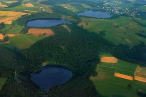
Three water-filled maars in the Eifel, Germany (Gemündener Maar, Weinfelder Maar, Schalkenmehrener Maar). Created by volcanic activity, maars are also found in other parts of Europe and on other continents, but Eifel-Maars are the classic example worldwide.
Credit: Martin Schildgen / Wikimedia Commons

Scientists have discovered new evidence for active volcanism next door to some of the most densely populated areas of Europe. The study ‘crowd-sourced’ GPS monitoring data from antennae across western Europe to track subtle movements in the Earth’s surface, thought to be caused by a rising subsurface mantle plume. The work is published in Geophysical Journal International.

The Eifel region lies roughly between the cities of Aachen, Trier, and Koblenz, in west-central Germany. It is home to many ancient volcanic features, including the circular lakes known as ‘maars’.

These are the remnants of violent volcanic eruptions, such as the one which created Laacher See, the largest lake in the area. The explosion that created this is thought to have occurred around 13,000 years ago, with a similar explosive power to the cataclysmic Mount Pinatubo eruption in 1991.

The mantle plume that likely fed this ancient activity is thought to still be present, extending up to 400km down into the Earth. However, whether or not it is still active is unknown: “Most scientists had assumed that volcanic activity in the Eifel was a thing of the past,” said Prof. Corné Kreemer, lead author of the new study. “But connecting the dots, it seems clear that something is brewing underneath the heart of northwest Europe.”

In the new study, the team — based at the University of Nevada, Reno and the University of California, Los Angeles in the United States — used data from thousands of commercial and state-owned GPS antennae all over western Europe, to map out how the ground is moving vertically and horizontally as the Earth’s crust is pushed, stretched and sheared.

The research revealed that the region’s land surface is moving upward and outward over a large area centred on the Eifel, and including Luxembourg, eastern Belgium and the southernmost province of the Netherlands, Limburg.

“The Eifel area is the only region in the study where the ground motion appeared significantly greater than expected,” adds Prof. Kreemer. “The results indicate that a rising plume could explain the observed patterns and rate of ground movement.”

The new results complement those of a previous study in Geophysical Journal International that found seismic evidence of magma moving underneath the Laacher See. Both studies point towards the Eifel being an active volcanic system.

The implication of this study is that there may not only be an increased volcanic risk, but also a long-term seismic risk in this part of Europe. The researchers urge caution however: “This does not mean that an explosion or earthquake is imminent, or even possible again in this area. We and other scientists plan to continue monitoring the area using a variety of geophysical and geochemical techniques, in order to better understand and quantify any potential risks.”

Reference:
Paul M Davis, Geoffrey Blewitt, Corné Kreemer. Geodetic evidence for a buoyant mantle plume beneath the Eifel volcanic area, NW Europe. Geophysical Journal International, 2020; 222 (2): 1316 DOI: 10.1093/gji/ggaa227

Note: The above post is reprinted from materials provided by Royal Astronomical Society.

Study shows diamonds aren’t forever

Graphite & Hexagonal Diamond
Representative image: Graphite & Hexagonal Diamond

Diamonds, those precious, sparkling jewels, are known as the hardest materials on Earth. They are a high-pressure form of carbon and found deep in the ground.

While diamonds are commonly thought of as hard and stable, carbon from about 100 miles beneath the African plate is being brought to shallower levels where diamond will become unstable. Molten rock (magma) brings the excess carbon towards the surface, and earthquakes open cracks that allow the carbon to be released into the air as carbon dioxide.

PhD student Sarah Jaye Oliva and Professor of Earth and Environmental Sciences and Marshall-Heape Chair in Geology Cynthia Ebinger are among a group of international researchers who co-authored a paper “Displaced cratonic mantle concentrates deep carbon during continental rifting,” which was published in the journal Nature on June 3.

“Somewhat amusedly,” Ebinger said, “the paper is evidence that Diamonds Aren’t Forever.”

The pair report on their findings about the African continent splitting in two and the massive amounts of CO2 (carbon dioxide) being released into the atmosphere.

Ebinger said of her student, “Sarah Jaye contributed to the gas measurements, and she analyzed the deep structure and state-of-stress data that enabled us to deduce the process leading to the excess CO2 in some rift zones.”

Oliva participated in a month-long campaign in 2018 to sample gases released diffusely through the soil and at springs that dot the East African Rift System in Tanzania.

Through the sampling, Oliva and other researchers found that CO2 fluxes [flows] and the number of earthquakes are highest where the rift intersects the edge of the ancient, thick cratonic plate that is more than 60 km (about 37 miles) thicker than the adjoining area.

Oliva said this made sense because the steep edge of the bottom of the plate is “where we expect magmas (molten rock material within the Earth that will cool to form igneous rock) to form and where faulting and fracture networks should be most intense.”

“The resulting faults and fissures, we think, act as conduits through the crust that concentrate fluxes of CO2 sourced from beneath,” said Oliva.

Modeling by the researchers also suggests that the mantle underneath the study region may be enriched in carbon due to the local erosion of the cratonic lithosphere that may even contain diamonds. (A craton is an old and stable part of the continental lithosphere, which consists of the Earth’s two topmost layers, the crust and the uppermost mantle.)

“The eroded material could melt as it moves towards thinner lithosphere, and this would be another factor in increasing the CO2 flux through the rift valley margin,” said Oliva.

She added, “Participating in this project was extremely rewarding for me. We, as seismologists, geodynamicists, structural geologists and geochemists all came together to understand how rifts help mobilize CO2 that is sequestered in the deep Earth. This newly liberated CO2 ultimately influences Earth’s climate over geologic time, temporarily contributing to global warming.”

Reference:
James D. Muirhead, Tobias P. Fischer, Sarah J. Oliva, Amani Laizer, Jolante van Wijk, Claire A. Currie, Hyunwoo Lee, Emily J. Judd, Emmanuel Kazimoto, Yuji Sano, Naoto Takahata, Christel Tiberi, Stephen F. Foley, Josef Dufek, Miriam C. Reiss, Cynthia J. Ebinger. Displaced cratonic mantle concentrates deep carbon during continental rifting. Nature, 2020; 582 (7810): 67 DOI: 10.1038/s41586-020-2328-3

Note: The above post is reprinted from materials provided by Tulane University.

Discovery of ancient super-eruptions indicates the Yellowstone hotspot may be waning

Yellowstone National Park is an American national park located in Wyoming, Montana, and Idaho.

Throughout Earth’s long history, volcanic super-eruptions have been some of the most extreme events ever to affect our planet’s rugged surface. Surprisingly, even though these explosions eject enormous volumes of material — at least 1,000 times more than the 1980 eruption of Mount St. Helens — and have the potential to alter the planet’s climate, relatively few have been documented in the geologic record.

Now, in a study published in Geology, researchers have announced the discovery of two newly identified super-eruptions associated with the Yellowstone hotspot track, including what they believe was the volcanic province’s largest and most cataclysmic event. The results indicate the hotspot, which today fuels the famous geysers, mudpots, and fumaroles in Yellowstone National Park, may be waning in intensity.

The team used a combination of techniques, including bulk chemistry, magnetic data, and radio-isotopic dates, to correlate volcanic deposits scattered across tens of thousands of square kilometers. “We discovered that deposits previously believed to belong to multiple, smaller eruptions were in fact colossal sheets of volcanic material from two previously unknown super-eruptions at about 9.0 and 8.7 million years ago,” says Thomas Knott, a volcanologist at the University of Leicester and the paper’s lead author.

“The younger of the two, the Grey’s Landing super-eruption, is now the largest recorded event of the entire Snake-River-Yellowstone volcanic province,” says Knott. Based on the most recent collations of super-eruption sizes, he adds, “It is one of the top five eruptions of all time.”

The team, which also includes researchers from the British Geological Survey and the University of California, Santa Cruz, estimates the Grey’s Landing super-eruption was 30% larger than the previous record-holder (the well-known Huckleberry Ridge Tuff) and had devastating local and global effects. “The Grey’s Landing eruption enamelled an area the size of New Jersey in searing-hot volcanic glass that instantly sterilized the land surface,” says Knott. Anything located within this region, he says, would have been buried and most likely vaporized during the eruption. “Particulates would have choked the stratosphere,” adds Knott, “raining fine ash over the entire United States and gradually encompassing the globe.”

Both of the newly discovered super-eruptions occurred during the Miocene, the interval of geologic time spanning 23-5.3 million years ago. “These two new eruptions bring the total number of recorded Miocene super-eruptions at the Yellowstone-Snake River volcanic province to six,” says Knott. This means that the recurrence rate of Yellowstone hotspot super-eruptions during the Miocene was, on average, once every 500,000 years.

By comparison, Knott says, two super-eruptions have — so far — taken place in what is now Yellowstone National Park during the past three million years. “It therefore seems that the Yellowstone hotspot has experienced a three-fold decrease in its capacity to produce super-eruption events,” says Knott. “This is a very significant decline.”

These findings, says Knott, have little bearing on assessing the risk of another super-eruption occurring today in Yellowstone. “We have demonstrated that the recurrence rate of Yellowstone super-eruptions appears to be once every 1.5 million years,” he says. “The last super-eruption there was 630,000 years ago, suggesting we may have up to 900,000 years before another eruption of this scale occurs.” But this estimate, Knott hastens to add, is far from exact, and he emphasizes that continuous monitoring in the region, which is being conducted by the U.S. Geological Survey, “is a must” and that warnings of any uptick in activity would be issued well in advance.

This study, which builds on decades of contributions by many other researchers, grew out of a larger project investigating the productivity of major continental volcanic provinces. Those with super-eruptions are the result of colossal degrees of crustal melting over prolonged periods of time, says Knott, and therefore have a profound impact on the structure and composition of Earth’s crust in the regions where they occur.

Because studying these provinces is vital to understanding their role in shaping our planet’s crustal processes, Knott hopes this research foreshadows even more revelations. “We hope the methods and findings we present in our paper will enable the discovery of more new super-eruption records around the globe,” he says.

Reference:
Robert S. Coe, Simon Tapster, David R. Finn, Marc K. Reichow, Michael J. Branney, Thomas R. Knott. Discovery of two new super-eruptions from the Yellowstone hotspot track (USA): Is the Yellowstone hotspot waning? Geology, 2020; DOI: 10.1130/G47384.1

Note: The above post is reprinted from materials provided by Geological Society of America.

New model shows how diamond-carrying rocks formed in Northern Alberta

Blue Diamond
A blue, boron-bearing diamond with dark inclusions of a mineral called ferropericlase, which were examined as part of this study. This gem weighs 0.03 carats. Credit: Photo by Evan Smith/GIA.

A new study by University of Alberta geologists is proposing a new model for explaining the eruption of diamond-bearing kimberlites in Northern Alberta.

The research demonstrates that 90 to 70 million years ago, the movement of an ancient slab of oceanic rocks buried hundreds of kilometres beneath Earth’s surface caused the eruption of diamond-bearing kimberlite in Northern Alberta.

“We are able to provide a new theory about why we have diamond-bearing kimberlites in Northern Alberta, which has been a source of debate for decades,” explained Yunfeng Chen, who conducted this research as part of his graduate studies with Jeffrey Gu, professor in the Department of Physics. “Our work is based on geological, paleomagnetic, and seismic data from our collaborators both at the University of Alberta and around the world.”

The model enables scientists to match the seismic structures with the time and location of kimberlite eruptions in the area, explaining how these diamonds came to Earth’s surface in the Late Cretaceous period — and providing key insight for those on the hunt for other deposits in the region.

“The kimberlites in Northern Alberta were discovered in relatively young parts of Earth’s crust — an unconventional setting for diamond-bearing kimberlites,” added Chen. “This distant location relative to other major kimberlite groups in North America plus the large variability of compositions further highlight the complex nature of the origins of kimberlite.”

The multidisciplinary study combines the work of geophysical imaging, geochronological dating, and plate motion calculation.

“What we have observed in Northern Alberta is similar to Hawaii,” said Gu. “In both scenarios, a relatively stationary mantle heat source essentially burned through the migrating plates above it, leaving ‘scars’ on the Earth’s surface. Diamonds were carried to the surface through this ‘upwelling’ process.”

A key difference is that the generation of the mantle upwelling in Northern Alberta took place no deeper than 700 kilometres below surface, whereas the ongoing Hawaii ‘plume’ appears to have occurred much deeper, at approximately 2,900 kilometres under Earth’s surface.

Reference:
Shu-Huei Hung, Erdinc Saygin, Lei Wu, Larry M. Heaman, Yu Jeffrey Gu, Yunfeng Chen. Reconciling seismic structures and Late Cretaceous kimberlitemagmatism in northern Alberta, Canada. Geology, 2020; DOI: 10.1130/G47163.1

Note: The above post is reprinted from materials provided by University of Alberta.

Scientists decipher the role of carbon and the break-up of continents

Proposed model for deep-carbon transport along a cratonic boundary in the EARS study region.

University of New Mexico (UNM) Professor of Earth and Planetary Sciences, Dr. Tobias Fischer and Syracuse University research fellow (now University of Auckland Lecturer), Dr. James Muirhead led an international team of interdisciplinary researchers to investigate the role of carbon in the break-up of continents.

This work, much of which has been funded by grants from the National Science Foundation, is a culmination of research efforts that started with former students from UNM and other US, French, Tanzanian and Kenyan universities.

The collaboration, which also included scientists from New Mexico Tech, the University of Oregon, University of Dar Es Salaam, Seoul National University, University of Tokyo, University of Alberta, Macquarie University, Goethe University and Université de Montpellier II, led to new insights into the storage and dynamic transfer of carbon below thick and very old continental crust currently published in the journal Nature titled, Displacement of cratonic mantle and lithospheric channeling concentrates deep carbon during continental rifting.

It was first recognized by former UNM student, now assistant professor at Seoul National University, Dr. Hyunwoo Lee, that the East African Rift and continental rifts in general are significant sources of carbon degassed from the Earth’s mantle to the atmosphere. While later work by other groups showed that CO2 emissions from the East African Rift are variable along its 3,000 km extent, the question remained “where does all this carbon come from and how is it so efficiently released?”

Subsequent work by Fischer and collaborator Professor Stephen Foley from Macquarie University, Australia, proposed a model in which the degassing CO2 is ultimately sourced from carbon that has accumulated over billions of years at the base of the thick old cratonic lithosphere located in the center and edge of the East African Rift.

“The model suggests that this accumulated carbon originates from subducting oceanic plates and deep mantle plumes,” said Fischer. “These processes could deliver sufficient carbon to the bottom of very thick and billion year old continental lithosphere to explain the high CO2 fluxes observed in the actively deforming part of the rift.”

However, the model proposed by Fischer and Foley could not explain how this deep CO2 managed to leak out from the actively extending part of the rift, which is exactly where the current work connects the dots.

Muirhead and Fischer together with Master’s student Amani Laizer from University of Dar Es Salaam in Tanzania and geophysics Ph.D. student Sarah Jaye Oliva from Tulane University returned to Tanzania in 2018 and collected data and samples in locations where active rifting,

i.e. where the plates move apart, intersect the old thick craton that lies above a mantle plume. Gas samples were collected from hot springs in this region that have never been sampled before.

The analyses of these samples within the context of already existing data from the earlier work showed a striking difference in chemical composition of the gases that are released from the active rift and the craton. Craton gases are entirely crustal with no sign of any mantle gases, including CO2. Nitrogen and crustal helium dominate these craton gases. Rift gases on the other hand are stuffed with mantle CO2 and have a strong mantle helium isotope signature. Measured mantle CO2 fluxes are close to zero on the craton but surge in the adjacent actively extending rift.

“Right at the boundary between the craton and the deforming rift sits the world’s only currently erupting carbonatite volcano, Oldoinyo Lengai,” said Fischer. “This volcano erupts lavas that are so liquid they move like motor oil. The reason for this is that they are devoid of the silica that makes up most igneous rocks but contain about 30 percent carbon, a staggeringly high amount that gives the rock its name carbonatite. Looking back in geologic time, it turns out that there are many carbonatite volcanoes right at the edge of the Tanzania craton, but they are just not currently active.”

This distribution of carbonatites led the team to propose a mechanism that causes the lateral migration of the deep cratonic lithosphere where all that stored solid carbon is located, into the mantle at the edges of the craton.

Geophysical data acquired and analyzed by Tulane University and Université de Montpellier II image a steep step in plate thickness at the craton edge. The geophysicists led by Professor Cindy Ebinger, Drs. Sarah Oliva and Professor Christel Tiberi proposed that this step enhances formation of melt and explains the concentration of magma that carries the excess CO2, as well as the spatial distribution of sometimes damaging earthquakes that open cracks for the CO2 to rise to the surface. This would explain the striking difference in CO2 release and source as documented by the surface measurements.

This conceptual model also fits into quantitative physical models developed by Dr. Jolante van Wjik, professor at New Mexico Tech and Dr. Claire Currie, professor at University of Alberta, which shows that unusually thick and low density mantle rocks beneath a craton will be swept laterally by mantle flow, moving toward the thinner plate beneath the continental rift.

This material transfer may enhance melt production. Therefore, the research team concluded, lateral migration of deep cratonic lithosphere soaked with ancient accumulated carbon is ultimately responsible for carbonatite volcanism and the on-going continental break-up in this region of East Africa.

Reference:
Muirhead, J.D., Fischer, T.P., Oliva, S.J. et al. Displaced cratonic mantle concentrates deep carbon during continental rifting. Nature, 2020 DOI: 10.1038/s41586-020-2328-3

Note: The above post is reprinted from materials provided by University of New Mexico. Original written by Steve Carr.

Scientists discover what an armored dinosaur ate for its last meal

Illustration of Borealopelta markmitchelli dinosaur by Julius Csotonyi. Credit: © Royal Tyrrell Museum of Palaeontology

More than 110 million years ago, a lumbering 1,300-kilogram, armour-plated dinosaur ate its last meal, died, and was washed out to sea in what is now northern Alberta. This ancient beast then sank onto its thorny back, churning up mud in the seabed that entombed it — until its fossilized body was discovered in a mine near Fort McMurray in 2011.

Since then, researchers at the Royal Tyrrell Museum of Palaeontology in Drumheller, Alta., Brandon University, and the University of Saskatchewan (USask) have been working to unlock the extremely well-preserved nodosaur’s many secrets — including what this large armoured dinosaur (a type of ankylosaur) actually ate for its last meal.

“The finding of the actual preserved stomach contents from a dinosaur is extraordinarily rare, and this stomach recovered from the mummified nodosaur by the museum team is by far the best-preserved dinosaur stomach ever found to date,” said USask geologist Jim Basinger, a member of the team that analyzed the dinosaur’s stomach contents, a distinct mass about the size of a soccer ball.

“When people see this stunning fossil and are told that we know what its last meal was because its stomach was so well preserved inside the skeleton, it will almost bring the beast back to life for them, providing a glimpse of how the animal actually carried out its daily activities, where it lived, and what its preferred food was.”

There has been lots of speculation about what dinosaurs ate, but very little known. In a just-published article in Royal Society Open Science, the team led by Royal Tyrrell Museum palaeontologist Caleb Brown and Brandon University biologist David Greenwood provides detailed and definitive evidence of the diet of large, plant-eating dinosaurs — something that has not been known conclusively for any herbivorous dinosaur until now.

“This new study changes what we know about the diet of large herbivorous dinosaurs,” said Brown. “Our findings are also remarkable for what they can tell us about the animal’s interaction with its environment, details we don’t usually get just from the dinosaur skeleton.”

Previous studies had shown evidence of seeds and twigs in the gut but these studies offered no information as to the kinds of plants that had been eaten. While tooth and jaw shape, plant availability and digestibility have fuelled considerable speculation, the specific plants herbivorous dinosaurs consumed has been largely a mystery.

So what was the last meal of Borealopelta markmitchelli (which means “northern shield” and recognizes Mark Mitchell, the museum technician who spent more than five years carefully exposing the skin and bones of the dinosaur from the fossilized marine rock)?

“The last meal of our dinosaur was mostly fern leaves — 88 per cent chewed leaf material and seven per cent stems and twigs,” said Greenwood, who is also a USask adjunct professor.

“When we examined thin sections of the stomach contents under a microscope, we were shocked to see beautifully preserved and concentrated plant material. In marine rocks we almost never see such superb preservation of leaves, including the microscopic, spore-producing sporangia of ferns.”

Team members Basinger, Greenwood and Brandon University graduate student Jessica Kalyniuk compared the stomach contents with food plants known to be available from the study of fossil leaves from the same period in the region. They found that the dinosaur was a picky eater, choosing to eat particular ferns (leptosporangiate, the largest group of ferns today) over others, and not eating many cycad and conifer leaves common to the Early Cretaceous landscape.

Specifically, the team identified 48 palynomorphs (microfossils like pollen and spores) including moss or liverwort, 26 clubmosses and ferns, 13 gymnosperms (mostly conifers), and two angiosperms (flowering plants).

“Also, there is considerable charcoal in the stomach from burnt plant fragments, indicating that the animal was browsing in a recently burned area and was taking advantage of a recent fire and the flush of ferns that frequently emerges on a burned landscape,” said Greenwood.

“This adaptation to a fire ecology is new information. Like large herbivores alive today such as moose and deer, and elephants in Africa, these nodosaurs by their feeding would have shaped the vegetation on the landscape, possibly maintaining more open areas by their grazing.”

The team also found gastroliths, or gizzard stones, generally swallowed by animals such as herbivorous dinosaurs and today’s birds such as geese to aid digestion.

“We also know that based on how well-preserved both the plant fragments and animal itself are, the animal’s death and burial must have followed shortly after the last meal,” said Brown. “Plants give us a much better idea of season than animals, and they indicate that the last meal and the animal’s death and burial all happened in the late spring to mid-summer.”

“Taken together, these findings enable us to make inferences about the ecology of the animal, including how selective it was in choosing which plants to eat and how it may have exploited forest fire regrowth. It will also assist in understanding of dinosaur digestion and physiology.”

Borealopelta markmitchelli, discovered during mining operations at the Suncor Millennium open pit mine north of Fort McMurray, has been on display at the Royal Tyrrell Museum since 2017. The main chunk of the stomach mass is on display with the skeleton.

Other members of the team include museum scientists Donald Henderson and Dennis Braman, and Brandon University research associate and USask alumna Cathy Greenwood.

Research continues on Borealopelta markmitchelli — the best fossil of a nodosaur ever found — to learn more about its environment and behaviour while it was alive. Student Kalyniuk is currently expanding her work on fossil plants of this age to better understand the composition of the forests in which it lived. Many of the fossils she will examine are in Basinger’ collections at USask.

The research was funded by Canada Foundation for Innovation, Research Manitoba, Natural Sciences and Engineering Research Council of Canada, National Geographic Society, Royal Tyrrell Museum Cooperating Society, and Suncor Canada, as well as in-kind support from Olympus Canada.

Reference:
Caleb M. Brown, David R. Greenwood, Jessica E. Kalyniuk, Dennis R. Braman, Donald M. Henderson, Cathy L. Greenwood, James F. Basinger. Dietary palaeoecology of an Early Cretaceous armoured dinosaur (Ornithischia; Nodosauridae) based on floral analysis of stomach contents. Royal Society Open Science, 2020; 7 (6): 200305 DOI: 10.1098/rsos.200305

Note: The above post is reprinted from materials provided by University of Saskatchewan.

Palaeontologists create most detailed virtual 3-D-model of endocranial cast and blood vessels of head of ankylosaurian

What the ankylosaur Bissektipelta archibaldi might look like. Credit: the authors of the paper.

Palaeontologists from St Petersburg University have been the first to study in detail the structure of the brain and blood vessels in the skull of the ankylosaur Bissektipelta archibaldi, an herbivorous dinosaur somewhat similar in appearance to a modern armadillo. Scientists produced the first three-dimensional computer reconstruction of a dinosaur endocast made in Russia,a digital cast of its braincase. It made it possible to determine that ankylosaurs, and Bissektipelta in particular, were capable of cooling their brains, had an extremely developed sense of smell, and heard low-frequency sounds. However, their brains were one and a half times smaller than that of modern animals of the same size.

Ankylosaurs appeared on Earth in the middle of the Jurassic—about 160 million years ago—and existed until the end of the dinosaur era, which ended 65 million years ago. These herbivorous animals were somewhat reminiscent of modern turtles or armadillos, were covered with thick armour, and sometimes even had a bony club on the tail. The researchers became interested in the uniquely preserved remains of ankylosaurs from Uzbekistan. Although these fossils have been known for 20 years, only now have the scientists had an opportunity to study the specimens from the inside using cutting-edge methods.

During the study, the palaeontologists examined three fragments of fossil skulls of the ankylosaur Bissektipelta archibaldi. They were found during a series of international expeditions URBAC (Uzbek / Russian / British / American / Canadian Joint Paleontological Expeditions) in the late 1990s and early 2000s at the Dzharakuduk locality in the Central Kyzylkum Desert, Uzbekistan. The scientists emphasise that it is unique, in that numerous remains of representatives of ~90-million-year-old fauna can be found there. These include dinosaurs, pterosaurs, crocodiles, birds, mammals and other vertebrates.

“This is really one of the richest locations in the world. The fauna of Dzharakuduk now has more than 100 species of ancient vertebrates,” said Pavel Skutschas, associate professor at St Petersburg University and an expert in Mesozoic vertebrates. “Of course, such a diversity of life would not have been found without large-scale field studies. A series of nine URBAC expeditions, undertaken from 1997 to 2006, pooled together the efforts of palaeontologists from many countries in the search for the bones of ancient animals.”

The material that was collected at that time comprises dozens of fragments of skulls and skeletons, and hundreds of thousands of isolated bones. Scientists still use them in their research and say that will provide studies for many years to come. At present, the three fragments of fossil ankylosaur braincases from Uzbekistan are stored at the Zoological Institute of the Russian Academy of Sciences. However, they have been temporarily transferred for research to the Department of Vertebrate Zoology at St Petersburg University.

Ankylosaurs lived on our planet for 100 million years

“Thanks to the development of computed tomography (CT) over the past 15 to 20 years, palaeontologists are able to learn more and more about the dinosaur brain and its structure,” said Ivan Kuzmin, the lead author of the article and a doctoral student at St Petersburg University.

“We decided to re-describe Bissektipelta archibaldi, and we managed to clarify its place on the phylogenetic tree of ankylosaurs. A 3-D reconstruction of the endocast of its brain cavity was made using CT. It is important to understand that the digital ‘cast’ of the braincase is not the brain itself. It is necessary to study it carefully to understand how big the actual brain was, where its parts were, how the vessels and nerves were housed.”

After meticulous work that lasted for three years, the scientists determined that a considerable part of the brain of Bissektipelta archibaldi was occupied by olfactory bulbs—about 60% of the size of the cerebral hemispheres. Bissektipelta likely had an extremely developed sense of smell, which probably helped it to look for food, the opposite sex, and to feel the approach of predators in time. It was of vital importance to know about any danger in advance because ankylosaurs had such heavy armor and a clumsy figure. The olfaction of ankylosaurs can even be compared with the olfaction of the famous predator Tyrannosaurus rex. Its olfactory bulbs were even larger, as they occupied about 65-70% of the size of the large hemispheres.

“Another interesting skill of the ankylosaur that we learned about is the ability to cool its brains in the literal sense,” said Ivan Kuzmin. “The network of veins and arteries in its braincase turned out to be very complicated: They did not go in a single direction, but constantly communicated with each other, like a system of railway tracks. The blood could have flowed in different directions and been redistributed, while maintaining the optimal brain temperature of the animal. For example, if the top of an ankylosaur’s head became warm, the vessels quickly diverted the warm blood and created a screening effect—as if a dinosaur put a sun hat on. Moreover, the endocranial vasculature of ankylosaurs turned out to be somewhat more like the vessels of present-day lizards than that of the closer extant relatives of dinosaurs—crocodiles or birds.”

Another important conclusion concerns the hearing of Bissektipelta archibaldi. The palaeontologists managed to examine the inner ear of the ancient animal. Its anatomy suggests the frequency of sounds that the ankylosaur could hear. The range turned out to have been from about 300 to 3,000 hertz—present-day crocodiles hear in the same range. These are quite low frequencies that correspond to the relatively large size of ankylosaurs. The larger the present-day animals are, the more low-frequency sounds they make and hear. The palaeontologists suggested that, during evolution, ankylosaurs increased in size, so later forms perceived sounds of even lower frequencies.

“Present-day animal species are characterized by a certain brain-body size relationship,” explained Ivan Kuzmin. “If you look at dinosaurs, then ankylosaurs and their closest relatives (stegosaurs) were almost outsiders. The mass of their brain turned out to be at least half less than what we would expect, based on a comparison with present-day animals. It was about 26.5 grams for a three-meter Bissektipelta. Its brain size can be compared with two walnuts. Nevertheless, ankylosaurs existed on the planet for 100 million years. They were quite successful in terms of evolution. However, judging by the size of their olfactory bulbs, they sniffed a little faster than they thought.”

At the next stage of their research, the scientists would like to study the fossil braincases of other species of ankylosaurs in order to test the hypotheses expressed in the paper. Additionally, the palaeontologists continue to use computed tomography and are currently working with digital endocranial casts of hadrosaurs—duck-billed dinosaurs whose remains were found at the same locality in Uzbekistan.

The research is published in Biological Communications.

Note: The above post is reprinted from materials provided by St. Petersburg State University.

Argentine paleontologists discover small carnivorous dinosaur

The fossilized jaw of an Overoraptor chimentoi, a new species of dinosaur discovered in Argentine Patagonia

Fossilized remains of a new species of dinosaur that lived 90 million years ago have been discovered in Patagonia, Argentine paleontologists announced on Thursday.

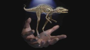
The winged dinosaur had legs similar to the velociraptor and experts believe it may hold the key to revealing information about the evolution of birds.

The fossil remains, which measure less than a meter and a half in length, were discovered at a dig in the province of Rio Negro in Argentine Patagonia, around 1,100 kilometers (685 miles) from Buenos Aires, the scientific dissemination agency from the La Matanza university said.

It is a new species of carnivorous Paraves theropod that has been named Overoraptor chimentoi, explained Matias Motta, a researcher from the Argentine natural sciences museum.

It is related to another species found more than 10,000 kilometers away in Madagascar.

The first remains were discovered in 2013, with more fossils found in a second dig in 2018.

“This animal had a very sharp claw on its index toe, which certainly was used to attack prey, and it had a long and graceful leg, which indicates it was a running animal,” said Motta, the main author of the study published in The Science of Nature magazine.

“It was certainly fast, agile and, like all its relatives, it would have been carnivorous.”

Researchers were surprised to find that while its legs were similar to the “raptor” family of dinosaurs, its upper limbs were very long and robust, similar to modern birds.

The second dig uncovered many bones, including an almost complete foot, tail vertebrae and parts of a wing, said paleontologist Federico Brisson Egli.

Previous discoveries in Patagonia of dinosaurs with bird-like features belonged to the Unenlagia genus of dromaeosaurid theropods, which were agile and walked on their hind legs.

“Contrary to what we originally assumed, the Overoraptor is not part of the Unenlagia family, but from another group including a Madagascan species called Rahonavis,” said paleontologist Fernando Novas.

Note: The above post is reprinted from materials provided by AFP.

Nevada home to 246M-year-old fossil of pregnant ichthyosaur

Ichthyosaur
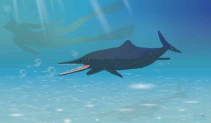
Image of pregnant ichthyosaur with octuplets. Credit: Copyright Nobumichi Tamura

Autumn was closing in fast on northern Nevada when Martin Sander took one last look around the excavation site in the Augusta Mountains 150 miles (241 kilometers) east of Reno.

The longtime paleontologist from Germany had been working summers in Nevada for 20 years by that point and believed in the maxim that, “we find the spectacular things on the second to last day or last day.”

It was Oct. 3, 2011, and Sander and his team were nearing the end of a two-week expedition in an area that’s a hotspot for ichthyosaur fossils.

Just getting to the site requires hours of driving on dirt from Winnemucca or Lovelock and hours more hiking from base camp.

When the team packs up and leaves for the season they know it might be months, or even years, before they return.

Sander’s decision to take another trip around the site proved fateful.

“The trick is you have to know what you are looking for,” said Sander, who described that final stroll as “wandering around in the field.”

At an outcropping around 6,000 feet (1,829 meters) in elevation he spotted what appeared to be fossilized remains of an ichthyosaur spine. Further, there was evidence the large, prehistoric, swimming reptile had been pregnant when it died.

“I found it and realized pretty quickly what I was looking at,” Sander said.

The next day, with cold and snow closing in, the team packed up the exposed fossils for further research. They returned in 2014 and excavated the rest.

Last month, they published a paper on the findings.

The ichthyosaur was the second-oldest pregnant specimen ever found and it was of a species that had never before been identified.

Even more remarkable, it was just one of two major ichthyosaur findings at the location in the Augusta Mountains.

“It is an incredible place and there is new stuff coming out all the time,” Sander said. “Everything we touch, new stuff is coming out of it.”

The other finding hasn’t yet been published in an academic journal, but it involves an ichthyosaur fossil Sander refers to as “the giant skull.”

While the paper detailing the specifics of the giant skull fossil aren’t yet published, Sander says the findings are, well, big.

“It is the first big thing that lived on this earth,” he said of the beast, which had a skull so big researchers had to borrow a beer truck to haul it away.

Although “the giant skull” may prove the more significant of the two recent discoveries, Sander says there’s plenty to celebrate about the pregnant ichthyosaur dubbed “Martina,” by the scientists.

For starters, at 246 million-years-old Martina is the second-oldest specimen of a pregnant ichthyosaur. The oldest is a 249-million-year-old specimen from China.

Martina is also a species of ichthyosaur, Cymbospondylus duelferi, that hasn’t been found anywhere else, according to Sander’s research.

Researchers know because literature reviews that were part of the scientific reporting showed Martina had characteristics not found in any other ichthyosaur fossils.

At about 12 feet (3.6 meters) long she was smaller than other ichthyosaurs, some of which are as large as 60 feet (18 meters) . Despite her smaller body, Martina’s teeth were larger than expected for an ichthyosaur of similar size.

The teeth, about an inch in length, would have helped her tear up prey such as squid or fish that were in the sea that covered what is now Nevada.

“She was a pretty fierce lady,” Sander said, comparing her to a much larger sample found in another Nevada range. “She is half the size but her teeth are nearly as big as the bigger one from the Humboldt Range.”

Martina and “the giant skull” also add to the diversity of Nevada’s ichthyosaur legacy. The specimens, both from the early triassic period, show how quickly life evolved following the Permian-Triassic extinction event.

The extinction event, which is thought to have wiped out as many as 96% of species, happened 252 million years ago.

That ichthyosaurs of immense size and diversity are found dating back to a few million years later suggests the animals evolved relatively quickly.

“The cool thing about it is … they just diversified crazily fast,” Sander said. “In Nevada you see this incredible explosion of ichthyosaurs.”

One of the reptiles’ adaptations, as Martina demonstrates, is they would have evolved from laying eggs to giving live birth, which would have been an advantage in their move to the sea, Sander said.

He compared it to the advantage a whale or dolphin has over a sea turtle, the latter of which is exposed, along with offspring, to danger by having to leave the water to lay eggs on shore.

“Most of the reptiles that returned to the sea, they all evolved this ability from egg laying to giving birth to live young,” he said.

While both Martina and the giant skull are exciting to researchers like Sander, they’ve also captured the imagination of people like craft brewer Tom Young, who has emerged as a major paleontology booster in Nevada.

Young, a former geologist, is the founder of Great Basin Brewing in Reno, which produces Ichthyosaur, or Icky, IPA. It was his beer truck researchers used to haul the giant skull from the Augusta Mountains to the Los Angeles Museum of Natural History.

And it’s Young whose made it his mission to popularize paleontology in Nevada.

“It is so important we preserve this and study these things to show where we are today and how we got here,” Young said. “You marvel as a human and realize the importance of our being here now, but at the same time you are looking at us as part of this much larger, huge universe.”

Young’s enthusiasm carries over to financial support. He’s contributed thousands of dollars, and plenty of beer, to research efforts. He’s also hosted brewery fundraisers that attract hundreds of people who want to hear directly from the scientists.

“I’m ecstatic when people give a crap about science,” Young said.

All three said they’d like to see the state develop a repository with the tools and talent to meet requirements for keeping ichthyosaur fossils recovered from public land.

Nevada’s Berlin-Ichthyosaur State Park retains fossils that are on display as they were found. But many significant finds are trucked to Berkeley or Los Angeles where there are repositories that meet federal standards.

“It should give Nevada some great pride we have some the coolest and biggest and meanest things to evolve on Earth here in our backyard,” Young said.

In recent years some of the most significant ichthyosaur findings have been outside Nevada, including an amphibious ichthyosaur from China that filled an evolutionary gap and a fossil in the United Kingdom from an ichthyosaur thought to be among the largest animals to ever live on the planet.

The paper on Martina and upcoming revelations about the giant skull will likely bring Nevada back into the spotlight.

Paula Noble, a professor of paleontology at University of Nevada, Reno, said that’s good news if it inspires more interest in science, especially among young people.

“Paleo is a great hook,” said Noble. “It is not just this stodgy thing we do in a lab.”

Note: The above post is reprinted from materials provided by The Associated Press.

Philippine volcanic eruption could prompt El Nino warming next winter

El Niño events and high-latitude Eurasian warming are usually observed after large tropical eruptions. However, simulations of climate impacts by volcanos show large biases when compared with observations, calling for substantial improvements in climate models. The graph depicts the change in zonally averaged surface temperature in observations (the shaded part) and simulations (the line) after large tropical volcanic eruptions. The equation denotes the chemical reaction in the stratosphere. Credit: Advances in Atmospheric Sciences

Climatologists have found that if an ongoing Philippine volcanic eruption becomes more violent, the gases released are likely to produce an El Niño event during the 2020-21 winter, a more intense polar vortex and warming across Eurasia.

When Taal volcano near Manila started erupting on January 12, ash spewed 14 kilometers into the air, coating villages in a blanket of dust and affecting nearly 460,000 people, many of whom lost access to electricity and fresh water. Despite the significant impact, the eruption so far has been tame compared to some of the biggest eruptions in history, and the Philippine Institute of Volcanology and Seismology (PHIVOLCS) has since downgraded its alert.

But these same volcanologists now warn that the Taal volcano may merely be in a lull and that the risk of a more dangerous eruption still exists.

“The Taal eruption has been terrible for local communities,” said Fei Liu, a researcher with China’s Sun Yat-sen University, “but it has also become a deep global concern, with potentially hazardous consequences for the Earth’s climate.”

Fine ash and sulfur dioxide from eruptions block incoming solar radiation, thus reducing heat at Earth’s surface that in turn produces atmospheric warming. As a result, for a year after especially violent eruptions, temperatures can be cooler than normal across much of the planet. But in addition to the cooling, there can also be a warming in the first post-eruption winter in the northern hemisphere as surface temperatures rebounds.

However, there are still some gaps between the climate impacts of volcanoes projected by computer simulations and what observations demonstrate. So Liu’s team are using the Taal eruption as a real-time assessment tool of the impact of volcanic eruptions on the climate in order to improve models.

The team’s research, joined by scientists from Nanjing University of Information Science and Technology, University of Hawaii, Zhejiang University, Institute of Atmospheric Physics at Chinese Academy of Sciences, Nanjing Normal University, and University of Gothenburg, is reported as a “News &Views” article in Advances in Atmospheric Sciences.

The researchers took data on the scale of volcanic eruptions worldwide over the past 1,100 years taken from Greenland and Antarctica ice cores and inputted this into global climate models. This then allowed them to project the impact of the Taal eruption.

They reckon there is a high likelihood (83% probability) of an El Niño-like warming event during the 2020/21 winter if the magnitude of the Taal eruption reaches a mid-range “volcanic explosive index”. Such an eruption would also produce an enhanced polar vortex— a large area of low pressure and cold air surrounding the Earth’s North and South poles, which in turn would drive warming across the Eurasian continent.

The researchers’ next step will be to use the eruption to better assess impacts from stratospheric aerosol geo-engineering (also known as solar radiation management), a theoretical method of reducing global warming by injecting sulfate aerosols into the stratosphere via balloons that would work as a sort of ‘deliberate’ volcanic eruption.

Reference:
Fei Liu et al, Could the Recent Taal Volcano Eruption Trigger an El Niño and Lead to Eurasian Warming?, Advances in Atmospheric Sciences (2020). DOI: 10.1007/s00376-020-2041-z

Note: The above post is reprinted from materials provided by Chinese Academy of Sciences.

New study reveals cracks beneath giant, methane gushing craters

The deep origin of craters and mounds was discovered using cutting edge 3D seismic technology which can penetrate deep into the ocean floor, and help scientists visualize the structures in the hard bedrock underneath. Illustration: M. Waage

A paper published in Science in 2017 described hundreds of massive, kilometer -wide, craters on the ocean floor in the Barents Sea. Today more than 600 gas flares are identified in and around these craters, releasing the greenhouse gas steadily into the water column. Another study, published the same year in PNAS, mapped several methane mounds, some 500m wide, in the Barents Sea. The mounds were considered to be signs of soon-to-happen methane expulsions that have created the said craters.

The most recent study in Scientific Reports looks into the depths far beneath these craters in the ocean floor and reveals the geological structures that have made the area prone to crater formation and subsequent methane expulsions.

“It turns out that this area has a very old fault system — essentially cracks in bedrock that likely formed 250 million years ago. Craters and mounds appear along different fault structures in this system. These structures control the size, placement, and shape of the craters. The methane that is leaking through the seafloor originates from these deep structures and is coming up through these cracks.” according to Malin Waage, a postdoc at CAGE, Centre for Arctic Gas Hydrate, Environment and Climate, and the first author of the study.

Cutting edge 3D seismic technology

The deep origin of craters and mounds was discovered using cutting edge 3D seismic technology which can penetrate deep into the ocean floor, and help scientists visualize the structures in the hard bedrock underneath.

“Our previous studies in the area hypothesized that climate warming and the retreat of the ice sheet some 20,000 years ago, caused the gas hydrates beneath the ice to melt leading to abrupt methane release and creating craters.”

Gas hydrates are a solid form of methane, among others, that is stable in cold temperatures and under pressure, which an enormous ice sheet provides. As the ocean warmed up, and the pressure of the ice sheet lifted, the methane ice in the seafloor melted and thus the craters were formed.

“This study, however, ads several layers to that picture, as we now see that there has been a structural weakness beneath these giant craters, for much longer than the last 20,000 years. Deep below the seafloor, the expansion of gas and release of water build up a muddy slurry which eventually erupted through the fractures and caused seafloor collapses and craters in the hard bedrock. Think of it as a building: A roof of a building can cave in if the ground structure is weak. We believe that this is what happened in the crater area after the last glaciation.” says Waage.

The Barents Sea is poorly understood

The exploration of petroleum resources in the Barents Sea is a hot topic in Norway and beyond as the area is a part of a vulnerable Arctic ecosystem. But the area’s geological system is poorly understood.

“Our 3D survey covered approximately 20 percent of the entire crater area. We believe that it is important to understand if similar fault systems exist in the larger context of the Barents Sea because they potentially could pose a threat to marine operations.”

Some of the questions that scientists, society and the industry does not know the answer to are: Will these weak structures lead to unpredictable and explosive methane release? Can such release and related geohazards be triggered by drilling? And can the gas reach the atmosphere in case of abrupt blow-outs, adding to the greenhouse gas budget?

“There is still very much that we don’t know about this system. But we are currently collecting and analyzing new data in the Barents Sea, dominated by similar crater structures. This can help us map in bigger detail the fault systems and associated weakness. ” says Waage.

Reference:
Malin Waage, Pavel Serov, Karin Andreassen, Kate A. Waghorn, Stefan Bünz. Geological controls of giant crater development on the Arctic seafloor. Scientific Reports, 2020; 10 (1) DOI: 10.1038/s41598-020-65018-9

Note: The above post is reprinted from materials provided by CAGE – Center for Arctic Gas Hydrate, Climate and Environment.

World’s oldest bug is fossil millipede from Scotland

UT Austin scientists found that the fossil millipede Kampecaris obanensis was 425 million years old. Credit: British Geological Survey

A 425-million-year-old millipede fossil from the Scottish island of Kerrera is the world’s oldest “bug”—older than any known fossil of an insect, arachnid or other related creepy-crawly, according to researchers at The University of Texas at Austin.

The findings offer new evidence about the origin and evolution of bugs and plants, suggesting that they evolved much more rapidly than some scientists believe, going from lake-hugging communities to complex forest ecosystems in just 40 million years.

“It’s a big jump from these tiny guys to very complex forest communities, and in the scheme of things, it didn’t take that long,” said Michael Brookfield, a research associate at UT Austin’s Jackson School of Geosciences and adjunct professor at the University of Massachusetts Boston. “It seems to be a rapid radiation of evolution from these mountain valleys, down to the lowlands, and then worldwide after that.”

The research was recently published in the journal Historical Biology. Brookfield led the study with co-authors including Elizabeth Catlos, a professor in the Jackson School’s Department of Geological Sciences, and Stephanie Suarez, a doctoral student at the University of Houston who made improvements to the fossil dating technique used in the study when she was an undergraduate at the Jackson School.

The team found that the ancient millipede fossil is 425 million years old, or about 75 million years younger than the age other scientists have estimated the oldest millipede to be using a technique known as molecular clock dating, which is based on DNA’s mutation rate. Other research using fossil dating found that the oldest fossil of a land-dwelling, stemmed plant (also from Scotland) is 425 million years old and 75 million years younger than molecular clock estimates.

Although it’s certainly possible there are older fossils of both bugs and plants, Brookfield said that the fact they haven’t been found—even in deposits known for preserving delicate fossils from this era—could indicate that the ancient millipede and plant fossils that have already been discovered are the oldest specimens.

If that’s the case, it also means both bugs and plants evolved much more rapidly than the timeline indicated by the molecular clock. Bountiful bug deposits have been dated to just 20 million years later than the fossils. And by 40 million years later, there’s evidence of thriving forest communities filled with spiders, insects and tall trees.

“Who is right, us or them?” Catlos said. “We’re setting up testable hypotheses—and this is where we are at in the research right now.”

Given their potential evolutionary significance, Brookfield said that he was surprised that this study was the first to address the age of the ancient millipedes.

Suarez said a reason could be the difficulty of extracting zircons—a microscopic mineral needed to precisely date the fossils—from the ashy rock sediment in which the fossil was preserved. As an undergraduate researcher at the Jackson School, Suarez developed a technique for separating the zircon grain from this type of sediment. It’s a process that takes practice to master. The zircons are easily flushed away when trying to loosen their grip on the sediment. And once they are successfully released from the surrounding rock, retrieving the zircons involves an eagle-eyed hunt with a pin glued to the tip of a pencil.

“That kind of work trained me for the work that I do here in Houston,” Suarez said. “It’s delicate work.”

As an undergraduate, Suarez used the technique to find that a different millipede specimen, thought to be the oldest bug specimen at the time, was about 14 million years younger than estimated—a discovery that stripped it of the title of oldest bug. Using the same technique, this study passes the distinction along to a new specimen.

Reference:
M. E. Brookfield et al. Myriapod divergence times differ between molecular clock and fossil evidence: U/Pb zircon ages of the earliest fossil millipede-bearing sediments and their significance, Historical Biology (2020). DOI: 10.1080/08912963.2020.1761351

Note: The above post is reprinted from materials provided by University of Texas at Austin.
Study finds a (much) earlier birth date for tectonic plates

This artist’s impression shows a view of the surface of the planet Proxima b orbiting the red dwarf star Proxima Centauri, the closest star to the Solar System. The double star Alpha Centauri AB also appears in the image to the upper-right of Proxima itself. Proxima b is a little more massive than the Earth and orbits in the habitable zone around Proxima Centauri, where the temperature is suitable for liquid water to exist on its surface. (Illustration by ESO/M. Kornmesser)

Yale geophysicists reported that Earth’s ever-shifting, underground network of tectonic plates was firmly in place more than 4 billion years ago — at least a billion years earlier than scientists generally thought.

Tectonic plates are large slabs of rock embedded in the Earth’s crust and upper mantle, the next layer down. The interactions of these plates shape all modern land masses and influence the major features of planetary geology — from earthquakes and volcanoes to the emergence of continents.

“Understanding when plate tectonics started on Earth has long been a fundamentally difficult problem,” said Jun Korenaga, a professor of earth and planetary sciences in Yale’s Faculty of Arts and Sciences and senior author of the new study, published in Science Advances. “As we go back deeper in time, we have fewer geological records.”

One promising proxy for determining if tectonic plates were operational is the growth of continents, Korenaga said. This is because the only way to build up a continent-sized chunk of land is for surrounding surface rock to keep sinking deeply over a long period — a process called subduction that is possible only through plate tectonics.

In the new study, Korenaga and Yale graduate student Meng Guo found evidence of continental growth starting as early as 4.4 billion years ago. They devised a geochemical simulation of the early Earth based on the element argon — an inert gas that land masses emit into the atmosphere. Argon is too heavy to escape Earth’s gravity, so it remains in the atmosphere like a geochemical ledger.

“Because of the peculiar characteristics of argon, we can deduce what has happened to the solid Earth by studying this atmospheric argon,” Korenaga said. “This makes it an excellent bookkeeper of ancient events.”

Most of the argon in Earth’s atmosphere is 40Ar — a product of the radioactive decay of 40K (potassium), which is found in the crust and mantle of continents. The researchers said their model looked at the atmospheric argon that has gradually accumulated over the history of the planet to determine the age of continental growth.

Part of the challenge in creating their simulation, the researchers said, was incorporating the effects of a geological process called “crustal recycling.” This refers to the cycle by which continental crust builds up, then is eroded into sediments, and eventually carried back underground by tectonic plate movements — until the cycle renews itself.

The simulation thus had to account for argon gas emissions that were not part of continental growth.

“The making of continental crust is not a one-way process,” Korenaga said.

Reference:
Meng Guo, Jun Korenaga. Argon constraints on the early growth of felsic continental crust. Science Advances, 2020; 6 (21): eaaz6234 DOI: 10.1126/sciadv.aaz6234

Note: The above post is reprinted from materials provided by Yale University. Original written by Jim Shelton.

Asteroid, climate change not responsible for mass extinction 215 million years ago

URI graduate student Reilly Hayes (left) and undergraduate Amanda Bednarick examine an outcrop for fossils at Petrified Forest National Park as part of their research. Credit: Amanda Bednarick

A team of University of Rhode Island scientists and statisticians conducted a sophisticated quantitative analysis of a mass extinction that occurred 215 million years ago and found that the cause of the extinction was not an asteroid or climate change, as had previously been believed. Instead, the scientists concluded that the extinction did not occur suddenly or simultaneously, suggesting that the disappearance of a wide variety of species was not linked to any single catastrophic event.

Their research, based on paleontological field work carried out in sediments 227 to 205 million years old in Petrified Forest National Park, Arizona, was published in April in the journal Geology.

According to David Fastovsky, the URI professor of geosciences whose graduate student, Reilly Hayes, led the study, the global extinction of ancient Late Triassic vertebrates—the disappearance of which scientists call the Adamanian/Revueltian turnover—had never previously been reconstructed satisfactorily. Some researchers believed the extinction was triggered by the Manicouagan Impact, an asteroid impact that occurred in Quebec 215.5 million years ago, leaving a distinctive 750-square-mile lake. Others speculated that the extinction was linked to a hotter and drier climate that occurred at about the same time.

“Previous hypotheses seemed very nebulous, because nobody had ever approached this problem—or any ancient mass extinction problem—in the quantitative way that we did,” Fastovsky said. “In the end, we concluded that neither the asteroid impact nor the climate change had anything to do with the extinction, and that the extinction was certainly not as it had been described—abrupt and synchronous. In fact, it was diachronous and drawn-out.”

The Adamanian/Revueltian turnover was the perfect candidate for applying the quantitative methods employed by the research team, Fastovsky said. Because the fossil-rich layers at Petrified Forest National Park preserve a diversity of vertebrates from the period, including crocodile-like phytosaurs, armored aetosaurs, early dinosaurs, large crocodile-like amphibians, and other land-dwelling vertebrates, Hayes relocated the sites where known fossils were discovered and precisely determined their age by their position in the rock sequence. He was assisted by URI geosciences majors Amanda Bednarick and Catherine Tiley.

Hayes and URI Statistics Professor Gavino Puggioni then applied several Bayesian statistical algorithms to create “a probabilistic estimate” of when the animals most likely went extinct. This method allowed for an unusually precise assessment of the likelihood that the Adamanian vertebrates in the ancient ecosystem went extinct dramatically and synchronously, as would be expected with an asteroid impact.

Previous research concluded that the asteroid impact occurred 215.5 million years ago and the climate change some 3 to 5 million years later. The URI researchers demonstrated that the extinctions happened over an extended period between 222 million years ago and 212 million years ago. Some species of armored archosaurs Typothorax and Paratypothorax, for instance, went extinct about 6 million years before the impact and 10 million years before the climate change, while those of Acaenasuchus, Trilophosaurus and Calyptosuchus went extinct 2 to 3 million years before the impact. Desmatosuchus and Smilosuchus species, on the other hand, went extinct 2 to 3 million years after the impact and during the very early stages of the climate change.

“It was a long-lasting suite of extinctions that didn’t really occur at the same time as the impact or the climate change or anything else,” Fastovsky said. “No known instantaneous event occurred at the same time as the extinctions and thus might have caused them.”

The URI professor believes it will be difficult to apply these quantitative methods to calculate other mass extinctions because equally rich fossil data and precise radiometric dates for them aren’t available at other sites and for other time periods.

“This was like a test case, a perfect system for applying these techniques because you had to have enough fossils and sufficiently numerous and precise dates for them,” he said. “Other extinctions could potentially be studied in a similar way, but logistically it’s a tall mountain to climb. It’s possible there could be other ways to get at it, but it’s very time consuming and difficult.”

Note: The above post is reprinted from materials provided by University of Rhode Island.

Volcanic eruptions reduce global rainfall

Credit: Pohang University of Science & Technology (POSTECH)

Climate change is occurring all over the globe as 1°C increase in Earth’s surface temperature has led to the sea level rise, abrupt melting of the Arctic sea ice, and the increase in extreme weather events such as heat waves, droughts, and floods. To accurately predict the anthropogenic climate changes under the increase in greenhouse gases, it is important to understand the effects of natural factors such as solar and volcanic activities. A recent study has shown how global precipitation decreases when volcanoes erupt in the tropics.

Professor Seung-Ki Min and Dr. Seungmok Paik of Division of Environmental Science and Engineering at POSTECH and researchers from the French National Centre for Scientific Research, Swiss Federal Institute of Technology in Zurich, and University of Edinburgh have released new findings that the El Niño induced by volcanic eruptions plays a key role in the decrease in global precipitation. So far, studies have shown that volcanic activity reduces precipitation across the globe, but its specific mechanism had been unclear. These research results were recently published in Science Advances, a sister journal of Science.

During the two to three years following Mount Pinatubo’s eruption in 1991, the average global temperature fell by about 0.2 degrees. This is because the massive dust including sulfur dioxide emitted by the eruption reflected the light from the sun and blocked its heat from reaching the Earth’s surface. Volcanic activities, along with this cooling effect, reduce the global terrestrial precipitation but its amplitude greatly varies depending on climate model simulations. For the first time, the joint research team confirmed that the main factor for the drop in precipitation after volcanic eruptions is the difference in El Niño’s response.

El Niño is a natural climate variability that occurs every three to eight years, with weakened trade winds in the equatorial Pacific Ocean and warmer sea surface temperatures in the equatorial eastern Pacific, causing extreme weather conditions across the globe including drought and heavy rains. Under El Niño’s influence, precipitation reduction occurs especially in the global monsoon regions, including Southeast Asia, India, South Africa, Australia and northern South America.

The team compared several climate model simulations and found that El Niño appeared in the year following a volcanic eruption in most models, with a significant drop in precipitation around the global monsoon region. In particular, the strength of El Niño was different for each simulation, and the stronger the El Niño, the more pronounced the reduction in precipitation occurred. The research team also found that the stronger the volcanic forcing and the greater the warm water volume in the western Pacific Ocean, a stronger El Niño developed, which in turn intensified the reduction in precipitation.

These findings are expected to be used to identify the side effects of geoengineering techniques and to predict the climate of the later years. In particular, it suggests that if geoengineering techniques are used to reduce global warming by spraying sulfur dioxide — the main component of volcanic ash — in the lower stratosphere to imitate artificial volcanoes, they could produce unexpected side effect of changing the precipitation patterns across the globe.

Professor Seung-Ki Min stated, “If geoengineering techniques are applied to mimic volcanoes and block sunlight, drought and water shortages may increase significantly in the monsoon regions — home to two-thirds of the world’s population.”

This research was supported by the Mid-career Researcher Program of the National Research Foundation of Korea.

Reference:
Seungmok Paik, Seung-Ki Min, Carley E. Iles, Erich M. Fischer, Andrew P. Schurer. Volcanic-induced global monsoon drying modulated by diverse El Niño responses. Science Advances, 2020; 6 (21): eaba1212 DOI: 10.1126/sciadv.aba1212

Note: The above post is reprinted from materials provided by Pohang University of Science & Technology (POSTECH).

Related Articles