1. Lava Beds National Monument, California
Lava Beds National Monument in Siskiyou and Modoc County is located in north east California. This monument is located at the northeast edge of Medicine Lake Volcano and is the largest volcano in the Cascade region.
The region in and around Lava Beds National Monument lies at the junction of the Sierra-Klamath, Cascade, and the Great Basin physiographic provinces. The monument was established as a national monument on November 21, 1925, and includes more than 46,000 acres (190 km2).
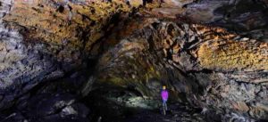
Lava Beds National Monument contains numerous lava tubes, 25 of which have marked entrances and established public access and exploration trails. The monument also provides paths through the xeric desert landscape of the high Great Basin and through the volcanic zone. The Modoc War was waged in 1872 and 1873, with a band commanded by Captain Jack (Kintpuash). The area in his memory was called Captain Jack’s Stronghold.
Lava Beds National Monument is geologically significant because of its wide variety of volcanic formations, including lava tubes, fumaroles, cinder cones, spatter cones, pit craters, hornitos, maars, lava flows, and volcanic fields.
Volcanic eruptions on the Medicine Lake shield volcano have created an incredibly rugged landscape punctuated by these many landforms of volcanism.
2. The Ice Age Flood Trail, Washington, Oregon and Idaho
The National Geologic Trail or Ice Age Floods Trail is known as the United States ‘ first National Geologic Trail. It will consist of a network of linking routes that will provide explanation of the geological effects of the last glacial period’s Glacial Lake Missoula floods that started around 110,000 years ago.
The National Park Service (NPS) commissioned an Environmental Assessment that found that Option 3 — setting up a “National Geological Trail — designating National Park Service Floods Pathways, with an Interagency Technical Committee including federal, tribal and state agencies and a Trail Advisory Committee to assist trail managers and staff” was the preferred optium. As a result, the Ice Age Floods Trail was created by the 2009 Omnibus Public Land Management Act, which allowed Congress to create the Ice Age Floods National Geologic Trail in parts of the states of Montana, Idaho, Washington, and Oregon, and formed the Trail’s NPS administration.
3. Mammoth Cave National Park, Kentucky
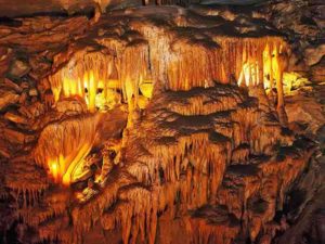
Mammoth Cave National Park is an American national park located in central Kentucky that includes parts of Mammoth Cave, the world’s longest known cave system. The system’s official name has been the Mammoth–Flint Ridge Cave System since the 1972 merger of Mammoth Cave with the even-longer system under Flint Ridge to the north. The park was established on 1 July 1941 as a national park, on 27 October 1981 as a World Heritage Site, and on 26 September 1990 as an international biosphere reserve.
The 52,830-acre park (21,380 ha) is mainly located in Edmonson County, with small areas spreading eastward to the counties of Hart and Barren. The Green River runs through the park, flowing into the Green just inside the park by a tributary named the Nolin River. Mammoth Cave is the longest known cave system in the world with more than 400 miles (640 km) of surveyed caves, which is almost twice as long as Mexico’s second-longest cave system, the Sac Actun underwater cave.
4. San Andreas Fault at the Carrizo Plain, California
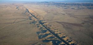
Credit: Wikipedia.
In the southeast of San Luis Obispo County, California, about 100 miles (160 km) northwest of Los Angeles, the Carrizo Plain is a large enclosed grassland plain, about 50 miles (80 km) wide and up to 15 miles (24 km) across. It includes the Carrizo Plain National Monument of 246,812 acres (99,881 ha) and is California’s largest single native grassland. It includes Painted Rock in the Carrizo Plain Rock Art Discontiguous District, which is listed on the National Register of Historic Places. In 2012 it was further designated a National Historic Landmark due to its archeological value. The San Andreas Fault cuts across the plain.
The Carrizo Plain extends northwest from the town of Maricopa, following the San Andreas Fault. Bordering the plain to the northeast is the Temblor Range, on the other side of which is California’s Central Valley. Bordering the plain to the southwest is the Caliente Range. The community of California Valley is in the northern part of the plain. The average elevation of the plain is about 2,200 feet (670.6 m). Soda Lake, a 3,000-acre (12 km2) alkaline lake, is in the center of the plain with the popular Painted Rock containing Chumash and Yokut rock art nearby. As the central depression in an enclosed basin, Soda Lake receives all of the runoff from both sides of the plain. At 5,106 feet (1,556 m), Caliente Mountain, southwest of the plain, stands as the highest point in San Luis Obispo County. The climate type of the Carrizo Plain is semi-arid grassland. No trees grow there and the annual rainfall is around 9 inches (230 mm) per year.
5. La Brea Tar Pits, California

La Brea Tar Pits are a group of tar pits around which Hancock Park was built in Los Angeles urban area. Natural asphalt (also called asphalt, bitumen, pitch, or tar-brea in Spanish) has for tens of thousands of years sprung up from the ground in this area. Often the tar is coated with dirt, leaves, or water. The tar has preserved the bones of trapped animals for many years. The George C. Page Museum is devoted to exploring the tar pits and exhibiting the animals that died there. La Brea Tar Pits is a National Natural Landmark listed.
Tar pits are composed of heavy oil fractions called gilsonite, which seeped from the Earth as oil. In Hancock Park, crude oil seeps up along the 6th Street Fault from the Salt Lake Oil Field, which underlies much of the Fairfax District north of the park.[2] The oil reaches the surface and forms pools at several locations in the park, becoming asphalt as the lighter fractions of the petroleum biodegrade or evaporate.
The tar pits visible today are actually from a human excavation. The lake pit was originally an asphalt mine. The other pits visible today were produced between 1913 and 1915 when over 100 pits were excavated in search of large mammal bones. Various combinations of asphaltum, dust, leaves, and water have since filled in these holes. Normally, the asphalt appears in vents, hardening as it oozes out, to form stubby mounds. These can be seen in several areas of the park.
For hundreds of thousands of years, this seepage has been occurring. For time to time, asphalt formed a crust that was dense enough to trap wildlife, and layers of mud, dust, or leaves would cover the surface. Animals are going to walk in, get stuck and eventually die. Predators would enter and caught to eat the trapped animals. The asphalt soaks inside as the dead animals ‘ bones sink, turning them into a dark-brown or black hue. Lighter fractions of petroleum evaporate from the asphalt, leaving a more solid substance, which encases the bones. Dramatic fossils of large mammals have been extricated from the tar, but the asphalt also preserves microfossils: wood and plant remnants, rodent bones, insects, mollusks, dust, seeds, leaves, and even pollen grains. Examples of some of these are on display in the George C. Page Museum. Radiometric dating of preserved wood and bones has given an age of 38,000 years for the oldest known material from the La Brea seeps. The pits still ensnare organisms today, so most of the pits are fenced to protect humans and animals.
6. Mount St. Helens National Volcanic Monument, Washington
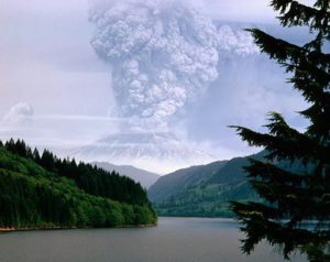
The National Volcanic Monument of Mount St. Helens is a U.S. National Monument, which covers the landscape surrounding Washington’s Mount St. Helens. It was created by the U.S. on August 27, 1982. After the eruption of 1980, President Ronald Reagan. The National Volcanic Monument of 110,000 acres (445 km2) has been set aside for science, tourism and education. The ecosystem within the Monument is left to respond to the disturbance naturally.
Mount St. Helens National Volcanic Monument was the first such monument operated by the United States of America. Service to the wood. Max Peterson, head of the USFS, said at dedication ceremonies on May 18, 1983, “we can be proud to have preserved the special episode of natural history for future generations.” Since then, several trails, viewpoints, information stations, campgrounds and picnic areas have been set up to accommodate the increasing number of visitors every year.
Beginning in 1983, visitors have been able to drive to Windy Ridge, only 4 miles (6.4 km) northeast of the crater.
Mountain climbing to the summit of the volcano has been allowed since 1986.
7. Meteor Crater, Arizona
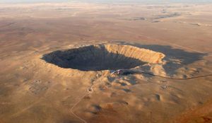
The crater was created about 50,000 years ago during the Pleistocene epoch, when the local climate on the Colorado Plateau was much cooler and damper. The area was an open grassland dotted with woodlands inhabited by mammoths and giant ground sloths.
Meteor Crater is about 37 miles (60 km) east of Flagstaff and 18 miles (29 km) west of Winslow in the United States ‘ northern Arizona desert. Since the U.S. Geographic Names Board generally honors names of natural features originating from the nearest post office, the feature obtained the name “Meteor Crater” from the local post office called Meteor. Formerly known as the Canyon Diablo Crater, the site is officially called the Canyon Diablo Meteorite, and parts of the meteorite.
The crater is referred to by scientists as Barringer Crater in honor of Daniel Barringer, who first claimed that it was created by meteorite impact. The crater is owned by the Barringer family privately through its Barringer Crater Company, which claims to be the “best preserved meteorite crater on Earth.” The crater is not protected as a national monument, given its significance as a geological site, a designation that would entail federal ownership. In November 1967, it was designated as a National Natural Landmark.
Meteor Crater is located at an elevation above sea level of 5,640 ft (1,719 m). It is approximately 3,900 ft (1,200 m) in diameter, approximately 560 ft (170 m) deep, and is surrounded by a 148 ft (45 m) rim above the surrounding plains. The crater center is filled with rubble lying above crater bedrock with 690–790 ft (210–240 m). One of the crater’s interesting features is its squared-off outline, which is thought to be caused by existing regional joints (cracks) at the impact site in the strata.
8. Niagara Falls, New York
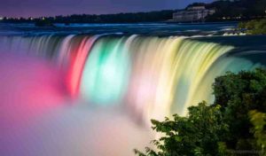
Niagara Falls is a town in the county of Niagara, New York, USA. The city had a total population of 50,193 as of the 2010 census, down from the 55,593 reported in the census of 2000. It is adjacent to the Niagara River, across the Niagara Falls city, Ontario, and named after the famous Niagara Falls that they share. The city is located within the Metropolitan Statistical Area of Buffalo–Niagara Falls and the West New York region.
While the city was formerly occupied by Native Americans, in the mid-17th century, Europeans who migrated to the Niagara Falls began to open businesses and develop infrastructure. Scientists and entrepreneurs later started to harness the power of the Niagara River for electricity in the 18th and 19th centuries, and the city began to attract factories and other companies drawn by the prospect of inexpensive hydroelectric power. Nevertheless, after an attempt at urban renewal under then-Mayor Lackey, the city and region experienced an economic decline after the 1960s. When manufacturing left the city, old line affluent families moved to nearby suburbs and out of town, in line with the rest of the Rust Belt.
Despite the decline in heavy industry, Niagara Falls State Park and the downtown area closest to the falls continue to thrive as a result of tourism. The population, however, has continued to decline from a peak of 102,394 in the 1960s due to the loss of manufacturing jobs in the area.
9. Yellowstone National Park, Idaho, Montana and Wyoming
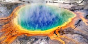
Yellowstone National Park is an American national park with small sections in Montana and Idaho, mainly located in Wyoming. It was set up by the U.S. Congress and President Ulysses S. Grant signed it into law on March 1, 1872. Yellowstone was the first national park in the U.S. and the first national park in the world is also widely held. The park is known for its wildlife and various geothermal features, including Old Faithful Geyser, one of its most popular features. It has many habitat types, but the most common is the subalpine forest. It is part of the South Central Rockies forests ecoregion.
Native Americans have existed for at least 11,000 years in the Yellowstone area. During the early-to-mid-19th century, apart from visits by mountain men, organized exploration did not begin until the late 1860s. Initially, the management and regulation of the park was under the authority of the Interior Secretary, the first being Columbus Delano. But the U.S. Subsequently, the Army was commissioned to oversee Yellowstone management for a period of 30 years from 1886 to 1916. In 1917, the park administration was moved to the National Park Service established the year before. Hundreds of structures have been built and are protected for their architectural and historical significance, and researchers have examined more than a thousand archaeological sites.
Yellowstone National Park covers an area of 8,983 km2 (3,468.4 square miles), and includes lakes, canyons, rivers and mountain ranges. Yellowstone Lake is one of North America’s largest high-altitude lakes, centered above the Yellowstone Caldera, the continent’s largest supervolcano. The caldera is a volcano that is dormant. Over the past two million years, it has exploded many times with tremendous force. Half of the geysers and hydrothermal properties of the planet are in Yellowstone, caused by this ongoing volcanism. Lava flows and volcanic eruptions rocks cover most of Yellowstone’s land area. The park is at the heart of the Greater Yellowstone Ecosystem, the largest remaining near-intact ecosystem in the northern temperate zone of the Earth. Yellowstone was declared a UNESCO World Heritage Site in 1978.
10. Grand Canyon, Arizona
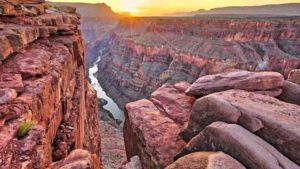
The Grand Canyon is a steep-sided canyon carved by the Colorado River in Arizona, United States. The Grand Canyon is 277 miles (446 km) long, up to 18 miles (29 km) wide and attains a depth of over a mile (6,093 feet or 1,857 meters).
Grand Canyon National Park, Kaibab National Forest, Grand Canyon-Parashant National Monument, Hualapai Indian Reservation, Havasupai Indian Reservation, and Navajo Nation contain the canyon and surrounding rim. President Theodore Roosevelt was a major supporter of protecting the Grand Canyon region, visiting it many times to hunt and enjoy the scenery.
Nearly two billion years of the geological history of Earth became uncovered as the Colorado River and its tributaries carved their channels through layer after layer of rock while the Colorado Plateau was elevated. While geologists are discussing some aspects of the canyon’s incision history, several recent studies support the hypothesis that the Colorado River set its course through the area about 5 to 6 million years ago. The Colorado River has since driven down the tributaries and the cliffs ‘ withdrawal, gradually deepening and widening the canyon.
The area has been inhabited continuously by Native Americans for thousands of years, who established villages within the canyon and its numerous caves. The inhabitants of the Pueblo saw the Grand Canyon as a sacred place and made pilgrimages to it. García López de Cárdenas, who arrived in 1540, was the first European known to have seen the Grand Canyon.


