Moeraki Boulders – New Zealand
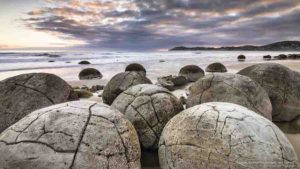
The Moeraki Boulders are unusually large and spherical boulders lying along a stretch of Koekohe Beach on the wave-cut Otago coast of New Zealand between Moeraki and Hampden. They occur scattered either as isolated or clusters of boulders within a stretch of beach where they have been protected in a scientific reserve. The erosion by wave action of mudstone, comprising local bedrock and landslides, frequently exposes embedded isolated boulders. These boulders are grey-colored septarian concretions, which have been exhumed from the mudstone enclosing them and concentrated on the beach by coastal erosion.
Local Māori legends explained the boulders as the remains of eel baskets, calabashes, and kumara washed ashore from the wreck of Arai-te-uru, a large sailing canoe. This legend tells of the rocky shoals that extend seaward from Shag Point as being the petrified hull of this wreck and a nearby rocky promontory as being the body of the canoe’s captain. In 1848 W.B.D. Mantell sketched the beach and its boulders, more numerous than now. The picture is now in the Alexander Turnbull Library in Wellington.[5] The boulders were described in 1850 colonial reports and numerous popular articles since that time. In more recent times they have become a popular tourist attraction, often described and pictured in web pages and tourist guides.
The most striking aspect of the boulders is their unusually large size and spherical shape, with a distinct bimodal size distribution. Approximately one-third of the boulders range in size from about 0.5 to 1.0 metre (1.6 to 3.3 ft) in diameter, the other two-thirds from 1.5 to 2.2 metres (4.9 to 7.2 ft). Most are spherical or almost spherical, but a small proportion are slightly elongated parallel to the bedding plane of the mudstone that once enclosed them.
Neither the spherical to subspherical shape or large size of the Moeraki Boulders is unique to them. Virtually identical spherical boulders, called Koutu Boulders, are found on the beaches, in the cliffs, and beneath the surface inland of the shore of Hokianga Harbour, North Island, New Zealand, between Koutu and Kauwhare points. Like the Moeraki Boulders, the Koutu Boulders are large, reaching 3 metres (10 ft) in diameter, and almost spherical.
Similar boulder-size concretions, known as Katiki Boulders, are also found on the north-facing shore of Shag Point some 19 kilometres (12 mi) south of where the Moeraki Boulders are found. These concretions occur as both spherical cannonball concretions and flat, disk-shaped or oval concretions. Unlike the Moeraki boulders, some of these concretions contain the bones of mosasaurs and plesiosaurs.
Large spherical concretions similar in size and shape to the Moeraki Boulders have been found in many other countries.
White Desert – Egypt
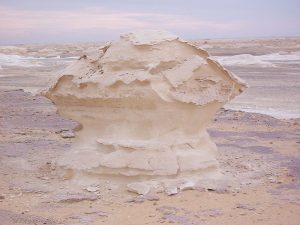
White Desert (known as Sahara el Beyda, with the word sahara meaning a desert). The White Desert of Egypt is located 45 km (28 mi) north of the town of Farafra. The desert has a white, cream color and has massive chalk rock formations that have been created as a result of occasional sandstorm in the area.
The majority of the valley is devoid of vegetation desert today. Rock and subsoil are usually made of limestone or chalk.
The valley is flat and is interrupted only by a few isolated standing conical hills – both north and south of the city of el-Farafra, they are called el-Qunna, mostly spoken el-Gunna (Arabic: القنة, al-Qunna, “the pinnacle “). East of el-Quss-Abu-Sa ? id plateaus are also numerous small limestone mountains witnesses.
The Giant’s Causeway – Northern Ireland
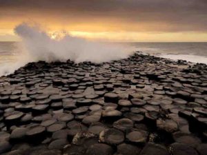
The Giant’s Causeway is an area of about 40,000 interlocking basalt columns, the result of an ancient volcanic fissure eruption. It is located in County Antrim on the north coast of Northern Ireland, about three miles (4.8 km) northeast of the town of Bushmills.
It was declared a World Heritage Site by UNESCO in 1986, and a national nature reserve in 1987 by the Department of the Environment for Northern Ireland. In a 2005 poll of Radio Times readers, the Giant’s Causeway was named as the fourth greatest natural wonder in the United Kingdom. The tops of the columns form stepping stones that lead from the cliff foot and disappear under the sea. Most of the columns are hexagonal, although there are also some with four, five, seven or eight sides. The tallest are about 12 metres (39 ft) high, and the solidified lava in the cliffs is 28 metres (92 ft) thick in places.
Much of the Giant’s Causeway and Causeway Coast World Heritage Site is today owned and managed by the National Trust and it is one of the most popular tourist attractions in Northern Ireland. The remainder of the site is owned by the Crown Estate and a number of private landowners.
Reed Flute Cave – Guangxi Province, China
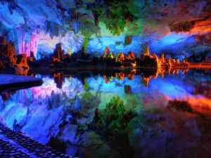
The Reed Flute Cave is a landmark and tourist attraction in Guilin, Guangxi, China. It is a natural limestone cave with multicolored lighting and has been one of Guilin’s most interesting attractions for over 1200 years.
It is over 180 million years old. The cave got its name from the type of reed growing outside, which can be made into melodious flutes. Reed Flute Cave is filled with a large number of stalactites, stalagmites and rock formations in weird and wonderful shapes. Inside, there are more than 70 inscriptions written in ink, which can be dated back as far as 792 AD in the Tang Dynasty.
Mono Lake – California
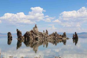
Mono Lake is a large, shallow saline soda lake in Mono County, California, formed at least 760,000 years ago as a terminal lake in an endorheic basin. The lack of an outlet causes high levels
of salts to accumulate in the lake. These salts also make the lake water alkaline.
This desert lake has an unusually productive ecosystem based on brine shrimp that thrive in its waters, and provides critical nesting habitat for two million annual migratory birds that feed on the shrimp and blackflies (that also feed on the shrimp). Historically, the native Kutzadika’a people derived nutrition from the Ephydra hians pupae, which live in the shallow waters around the edge of the lake having been hatched from the eggs of adult alkali flies.
When the city of Los Angeles diverted water from the freshwater streams flowing into the lake, it lowered the lake level, which imperiled the migratory birds. The Mono Lake Committee formed in response and won a legal battle that forced Los Angeles to partially replenish the lake level.
Devils Tower – Wyoming
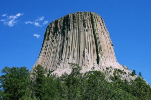
Devils Tower was the first declared United States National Monument, established on September 24, 1906, by President Theodore Roosevelt. The Monument’s boundary encloses an area of 1,347 acres (545 ha).
In recent years, about 1% of the Monument’s 400,000 annual visitors climbed Devils Tower, mostly using traditional climbing techniques.
Gibson Steps (The Twelve Apostles) – Great Ocean Road, Australia
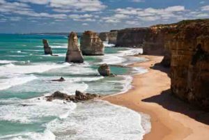
The Twelve Apostles is a collection of limestone stacks off the shore of the Port Campbell National Park, by the Great Ocean Road in Victoria, Australia. Their proximity to one another has made the site a popular tourist attraction. Currently there are eight apostles left, the ninth one of the stacks collapsed dramatically in July 2005. The name remains significant and spectacular especially in the Australian tourism industry.
Cave of the Crystals – Naica, Mexico
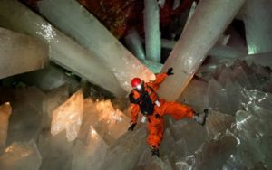
Cave of the Crystals or Giant Crystal Cave is a cave connected to the Naica Mine 300 metres (980 ft) below the surface in Naica, Chihuahua, Mexico.
One of the world’s most spectacular geographical discoveries was the cave of giant crystals with its selenite crystals of a size never seen before. most of them measure six meters in length, with some of them reaching eleven meters. the temperature at this depth varies from 45°C to 50°C, while the percentage of humidity ranges from 90 to 100%, meaning that human beings cannot survive there for longer than two hours.
Door to Hell “Gate to Hell” – Turkmenistan
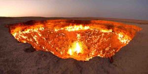
The “Door to Hell” is a natural gas field in Derweze, Turkmenistan, that collapsed into an underground cavern in 1971, becoming a natural gas crater. Geologists set it on fire to prevent the spread of methane gas, and it has been burning continuously since then. The diameter of the crater is 69 metres (226 ft), and its depth is 30 metres (98 ft).
Chocolate Hills – Philippines
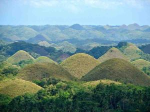
The Chocolate Hills (Cebuano: Mga Bungtod sa Tsokolate; Filipino: Mga Tsokolateng Burol) are a geological formation in the Bohol province of the Philippines. There are at least 1,260 hills but there may be as many as 1,776 hills spread over an area of more than 50 square kilometres (20 sq mi). They are covered in green grass that turns brown (like chocolate) during the dry season, hence the name.
The Chocolate Hills is a famous tourist attraction of Bohol. They are featured in the provincial flag and seal to symbolize the abundance of natural attractions in the province. They are in the Philippine Tourism Authority’s list of tourist destinations in the Philippines; they have been declared the country’s third National Geological Monument and proposed for inclusion in the UNESCO World Heritage List.
Salar de Uyuni – Bolivia
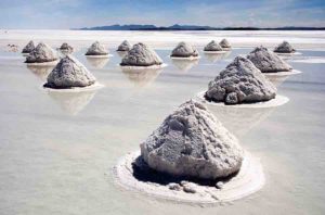
Salar de Uyuni (or Salar de Tunupa) is the world’s largest salt flat at 10 582 square kilometers (4 086 sq mi). It is in the Daniel Campos Province in Potosí in southwest Bolivia, near the crest of the Andes and is at an elevation of 3 656 meters (11 995 ft) above sea level.
The Salar was formed as a result of transformations between several prehistoric lakes. It is covered by a few meters of salt crust, which has an extraordinary flatness with the average elevation variations within one meter over the entire area of the Salar. The crust serves as a source of salt and covers a pool of brine, which is exceptionally rich in lithium. It contains 50 % to 70 % of the world’s known lithium reserves, which is in the process of being extracted. The large area, clear skies, and exceptional flatness of the surface make the Salar an ideal object for calibrating the altimeters of Earth observation satellites.
Stone Forest – China
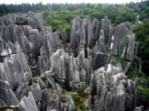
The Stone Forest or Shilin is a notable set of limestone formations about 500 km2 located in Shilin Yi Autonomous County, Yunnan Province, People’s Republic of China, near Shilin approximately 90 km (56 mi) from the provincial capital Kunming.
The tall rocks seem to arise from the ground in a manner somewhat reminiscent of stalagmites, or with many looking like petrified trees, thereby creating the illusion of a forest made of stone. Since 2007, two parts of the site, the Naigu Stone Forest (乃古石林) and Suogeyi Village (所各邑村), have been UNESCO World Heritage Sites as part of the South China Karst. The site is classified as a AAAAA-class tourist site.
Fairy Chimneys – Turkey
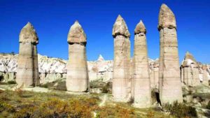
Cappadocia “Fairy Chimneys – Turkey” is a historical region in Central Anatolia, largely in the Nevşehir, Kayseri, Kırşehir, Aksaray, and Niğde Provinces in Turkey.
According to Herodotus, in the time of the Ionian Revolt (499 BC), the Cappadocians were reported as occupying a region from Mount Taurus to the vicinity of the Euxine (Black Sea). Cappadocia, in this sense, was bounded in the south by the chain of the Taurus Mountains that separate it from Cilicia, to the east by the upper Euphrates, to the north by Pontus, and to the west by Lycaonia and eastern Galatia.
The name, traditionally used in Christian sources throughout history, continues in use as an international tourism concept to define a region of exceptional natural wonders, in particular characterized by fairy chimneys and a unique historical and cultural heritage. is a historical region in Central Anatolia, largely in the Nevşehir, Kayseri, Kırşehir, Aksaray, and Niğde Provinces in Turkey.
The Jeita Grotto – Lebanon
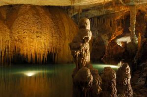
The Jeita Grotto is a system of two separate, but interconnected, karstic limestone caves spanning an overall length of nearly 9 kilometres (5.6 mi). The caves are situated in the Nahr al-Kalb valley within the locality of Jeita, 18 kilometres (11 mi) north of the Lebanese capital Beirut. Though inhabited in prehistoric times, the lower cave was not rediscovered until 1836 by Reverend William Thomson; it can only be visited by boat since it channels an underground river that provides fresh drinking water to more than a million Lebanese.
In 1958, Lebanese speleologists discovered the upper galleries 60 metres (200 ft) above the lower cave which have been accommodated with an access tunnel and a series of walkways to enable tourists safe access without disturbing the natural landscape. The upper galleries house the world’s largest known stalactite. The galleries are composed of a series of chambers the largest of which peaks at a height of 12 metres (39 ft).
Aside from being a Lebanese national symbol and a top tourist destination, the Jeita grotto plays an important social, economic and cultural role in the country. It was one of top 14 finalists in the New 7 Wonders of Nature competition.
Skaftafell – Iceland
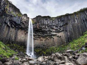
Skaftafell is a preservation area in Öræfi, southeast Iceland. It used to be a manor farm and a national park, but has been a part of Vatnajökull National Park since its establishment in 2008.
Skaftafell National Park was a national park, situated between Kirkjubæjarklaustur, typically referred to as Klaustur, and Höfn in the south of Iceland. On 7 June 2008, it became a part of the larger Vatnajökull National Park.
It was founded on September 15, 1967, and enlarged twice afterwards. Before its inclusion into Vatnajökull National Park, it measured about 4807 km2 (2884 mi2), making it Iceland’s second largest national park. It contains the valley Morsárdalur, the mountain Kristínartindar and the glacier Skaftafellsjökull (a spur of the Vatnajökull ice cap).
Puerto Princesa Underground River – Philippines
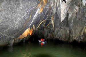
The Puerto Princesa Subterranean River National Park is a protected area of the Philippines located about 80 kilometres (50 mi) north of the city centre of Puerto Princesa, Palawan, and which contains the Puerto Princesa Underground River.
The park is located in the Saint Paul Mountain Range on the western coast of the island, and has been managed by the City Government of Puerto Princesa since 1992.
It was listed as a UNESCO World Heritage Site in 1999, and voted as a New7Wonders of Nature in 2012. It also became a Ramsar Wetland Site in 2012.
Yellowstone
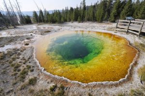
Yellowstone National Park is a national park located in the U.S. states of Wyoming, Montana, and Idaho. It was established by the U.S. Congress and signed into law by President Ulysses S. Grant on March 1, 1872. Yellowstone was the first national park in the U.S. and is also widely held to be the first national park in the world. The park is known for its wildlife and its many geothermal features, especially Old Faithful geyser, one of its most popular features. It has many types of ecosystems, but the subalpine forest is the most abundant. It is part of the South Central Rockies forests ecoregion.
Native Americans have lived in the Yellowstone region for at least 11,000 years. Aside from visits by mountain men during the early-to-mid-19th century, organized exploration did not begin until the late 1860s. Management and control of the park originally fell under the jurisdiction of the Secretary of the Interior, the first being Columbus Delano. However, the U.S. Army was subsequently commissioned to oversee management of Yellowstone for a 30-year period between 1886 and 1916. In 1917, administration of the park was transferred to the National Park Service, which had been created the previous year. Hundreds of structures have been built and are protected for their architectural and historical significance, and researchers have examined more than a thousand archaeological sites.
Arches National Park – Utah
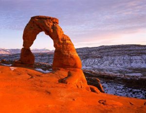
Arches National Park is a United States National Park in eastern Utah. The park is adjacent to the Colorado River, 4 miles (6 km) north of Moab, Utah. It is home to over 2,000 natural sandstone arches, including the world-famous Delicate Arch, in addition to a variety of unique geological resources and formations. It contains the highest density of natural arches in the world.
The park consists of 76,679 acres (119.811 sq mi; 31,031 ha; 310.31 km2) of high desert located in the Colorado Plateau. Its highest elevation is 5,653 feet (1,723 m) at Elephant Butte, and its lowest elevation is 4,085 feet (1,245 m) at the visitor center. Forty-three arches are known to have collapsed since 1977. The park receives on average 10 inches (250 mm) of rain a year.
Administered by the National Park Service, the area was originally named a National Monument on April 12, 1929. It was redesignated as a National Park on November 12, 1971.
Richat Structure “Eye of the Sahara” – Mauritania
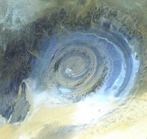
The Richat Structure, also known as the Eye of the Sahara and Guelb er Richat, is a prominent circular feature in the Sahara near Ouadane, west–central Mauritania.
The Richat Structure is a deeply eroded, slightly elliptical dome with a diameter of 40 kilometres (25 mi). The sedimentary rock exposed in this dome ranges in age from Late Proterozoic within the center of the dome to Ordovician sandstone around its edges. The sedimentary rocks comprising this structure dip outward at 10–20°. Differential erosion of resistant layers of quartzite has created high-relief circular cuestas. Its center consists of a siliceous breccia covering an area that is at least 30 kilometres (19 mi) in diameter.
Eisriesenwelt “World of Ice Giants” – Austria
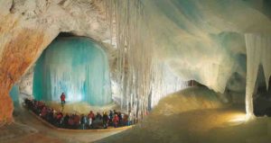
The Eisriesenwelt (German for “World of the Ice Giants”) is a natural limestone and ice cave located in Werfen, Austria, about 40 km south of Salzburg. The cave is inside the Hochkogel mountain in the Tennengebirge section of the Alps. It is the largest ice cave in the world, extending more than 42 km and visited by about 200,000 tourists every year.
The Tennengebirge mountains were formed during the late Tertiary period, during the Würm glaciation period of the Pleistocene. The mountain range, one of the massifs in the Austrian Alps, is the largest karst plateau in the Salzburger Alps, and the Eisriesenwelt is located at the rim of this plateau. Although the cave has a length of 42 km, only the first kilometer, the area that tourists are allowed to visit, is covered in ice. The rest of the cave is formed of limestone.
Eisriesenwelt was formed by the Salzach river, which eroded passageways into the mountain. The ice formations in the cave were formed by thawing snow which drained into the cave and froze during winter.
Since the entrance to the caves is open year-round, chilly winter winds blow into the cave and freeze the snow inside. In summer, a cold wind from inside the cave blows toward the entrance and prevents the formations from melting.
Babele – Romania
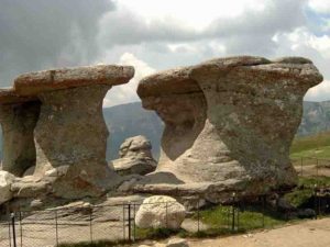
Babele (meaning The old women) is a name for an area on the Bucegi Mountains plateau in Romania, within the Southern Carpathians.
Babele is one of the most popular tourist destinations in the country. The name comes from some mushroom shaped rock formations, the result of erosion and varying hardness of the rock layers.
The Bucegi Sphinx is another rock formation in the same area, named for its sphinx-like appearance.
The Babele chalet is accessible either by cable car from Buşteni or by road. It can also be reached by foot, coming from Buşteni through Valea Jepilor (Juniper Valley), or from the crest of Bucegi Mountains, from the Piatra Arsă (The Burned Rock) challet.
The Wave – Arizona
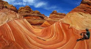
The Wave is a sandstone rock formation located in Arizona, United States near its northern border with Utah. The formation is situated on the slopes of the Coyote Buttes in the Paria Canyon-Vermilion Cliffs Wilderness of the Colorado Plateau. The area is administered by the Bureau of Land Management (BLM) at the Grand Staircase-Escalante National Monument visitor center in Kanab, Utah.
The formation is well-known among hikers and photographers for its colorful, undulating forms and the difficult hike required to reach it. Due to the fragile nature of the formation and the large number of people wishing to visit it, a daily lottery system is used to dispense only ten next-day permits in person at the Kanab visitor center. Additionally, ten online permits for each date are available four months in advance of a planned trip. A map and information about the hike are supplied to those who have obtained permits.
Punakaiki Pancake Rocks and Blowholes – New Zealand
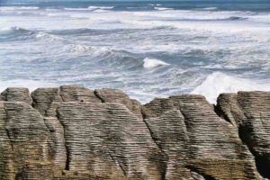
Punakaiki is a small community on the West Coast of the South Island of New Zealand, between Westport and Greymouth. The community lies on the edge of the Paparoa National Park.
The Pancake Rocks are a very popular tourist destination at Dolomite Point south of the main village. The Pancake Rocks are a heavily eroded limestone area where the sea bursts through several vertical blowholes during high tides. Together with the ‘pancake’-layering of the limestone (created by immense pressure on alternating hard and soft layers of marine creatures and plant sediments), these form the main attraction of the area.
The Pancake Rocks are presently explorable by a number of walkways winding through the rock formations, parts of these wheelchair-accessible and others carved into stairways up and down the rock faces. State Highway 6, the only through road on the West Coast, passes through the town.
Fingal’s Cave – Scotland
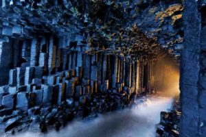
Fingal’s Cave is a sea cave on the uninhabited island of Staffa, in the Inner Hebrides of Scotland, known for its natural acoustics. The National Trust for Scotland owns the cave as part of a National Nature Reserve. It became known as Fingal’s Cave after the eponymous hero of an epic poem by 18th-century Scots poet-historian James Macpherson.


