A team of volcanologists and engineers from the Universities of Bristol and Cambridge have collected measurements from directly within volcanic clouds, together with visual and thermal images of inaccessible volcano peaks.
During a ten-day research trip the team carried out many proof-of-concept flights at the summits of both Volcán de Fuego and Volcán de Pacaya in Guatemala. Using lightweight modern sensors they measured temperature, humidity and thermal data within the volcanic clouds and took images of multiple eruptions in real-time.
This is one of the first times that bespoke fixed-wing unmanned aerial vehicles (UAVs) have been used at a volcano such as Fuego, where the lack of close access to the summit vent has prevented robust gas measurements. Funding from the Cabot Institute has helped the team to develop technologies to enable this capability. The UAVs were successfully flown beyond-visual-line-of-sight (BVLOS) at distances of up to 8 kilometres away, and 10,000 feet above the launch site.
The group plan to return to Guatemala later in the year with a wider range of sensors including a multiGAS gas analyser (CO2, SO2, H2S); a four-stage filter pack; carbon stubs for ash sampling; thermal and visual cameras, and atmospheric sensors.
Dr Emma Liu, Volcanologist from the Department of Earth Sciences at Cambridge, said: “Volcanoes are prodigious sources of volatiles and trace metals and have a key role in the geochemical cycling of these elements through the Earth system. Drones offer an invaluable solution to the challenges of in-situ sampling and routine monitoring of volcanic emissions, particularly those where the near-vent region is prohibitively hazardous or inaccessible. These sensors not only help to understand emissions from volcanoes, they could also be used in the future to help alert local communities of impending eruptions — particularly if the flights can be automated.”
Dr Tom Richardson, Senior Lecturer in Flight Dynamics in the Department of Aerospace Engineering at Bristol, explained: “Building on our award winning work on Ascension Island, the team carried out multiple beyond-visual-line-of-sight (BVLOS) flights from the observatory flying up to 10,000 feet above the launch site to reach the summit of Volcán de Fuego. Our success has resulted in direct invitations from the Dirección General de Aeronáutica Civil and Instituto Nacional de Sismología, Vulcanología, Meteorología e Hidrología to return and continue this ground-breaking work.”
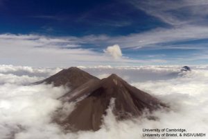
Dr Kieran Wood, Senior Research Associate in the Department of Aerospace Engineering at Bristol, added: “Even during this initial campaign we were able to meet significant science and engineering targets. For example, multiple imaging flights over several days captured the rapidly changing topography of Fuego’s summit. These showed that the volcano was erupting from not just one, but two active summit vents.”
Ben Schellenberg, a first year Aerospace Engineering PhD student at Bristol, expressed: “Being involved in a field trip of this type so early on in my PhD has been incredibly exciting. Initial analysis of the sensor and flight data tell us that we will be able to automatically identify when we are in volcanic emissions. I can’t wait to return to test out this hypothesis.”
Taking time out from their sample flights, the research group also used their aircraft to map the topology of a barranca and the volcanic deposits within it. These deposits were formed by a recent pyroclastic flow, a fast-moving cloud of superheated ash and gas, which travelled down the barranca from Fuego. The data captured will assist in modelling flow pathways and the potential impact of future volcanic eruptions on nearby settlements.
Dr Matt Watson, Reader in Natural Hazards in the School of Earth Sciences at Bristol, said: “This is exciting initial research for future investigations, and would not be possible without a very close collaboration between volcanology and engineering.”
The team of engineers and volcanologists involved in the research trip were: Dr Colin Greatwood, Dr Tom Richardson, Ben Schellenberg, Dr Helen Thomas, Dr Matt Watson, Dr Kieran Wood from the University of Bristol and Dr Emma Liu from the University of Cambridge.
Note: The above post is reprinted from materials provided by University of Bristol.


