Guatemala’s Pacaya volcano needs monitoring to prevent death and destruction from eruptions and landslides, and Michigan Technological University researchers are helping local residents and government agencies do just that.
As part of a two-year, $100,000 project, Thomas Oommen, Gregory Waite, and Rüdiger Escobar-Wolf have joined their Guatemalan counterparts scouting the countryside around the volcano to come up with the best sites for monitoring equipment. It’s the first step in compiling information to set up equipment for volcanic monitoring, part of a Society of Exploration Geophysicists-Geoscientists Without Borders (SEG-GWB) project.
“The infrastructure is not there,” said Oommen, assistant professor of geological and mining engineering and sciences. “They lack proper instrumentation, and we will overcome this challenge with seismic stations, GPS, high-resolution cameras and other devices to capture the data.”
They’ll also produce permanent displays explaining volcanic hazards and monitoring to inform local people and visiting tourists.
Oommen just returned from Guatemala, where he, geophysicist Waite and geological engineering postdoc Escobar-Wolf met with leadership of that country’s National Institute of Seismology, Volcanology, Meteorology, and Hydrology (INSIVUMEH), which monitors atmospheric, geophysical and hydrological phenomena and makes recommendations in case of natural disasters.
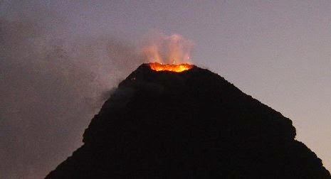
Monitoring Pacaya Volcano
The team also met with a group from the Instituto Geografico Nacional (IGN), which has ongoing studies of ground deformation around Pacaya, to discuss how best to integrate the new instrumentation with their existing monitoring program.
“The idea is to train the local agencies in the use of the equipment, so we can turn it over to them some day,” Oommen said. “The data obtained from this equipment will help several PhD students here to advance research on volcanic hazards.”
In addition to the work with these scientific agencies, a key meeting was held with leaders of the Pacaya National Park, the municipality of the area that surrounds the volcano, and the representatives from National Coordination Agency for Disaster reduction (CONRED), an agency responsible for risk reduction from a variety of hazards.
“These groups were all very keen to cooperate on the monitoring and outreach components of the project,” said Waite. “The success of this project hinges on this collaboration.”
The project also includes funding for thesis projects to be developed by students from San Carlos University in Guatemala, using the data that will be produced by the new monitoring equipment.
“The multidisciplinary approach involving the volcanologists at INSIVUMEH, the administration of the National Park, the academics from the San Carlos University, and collaborators in other agencies has a great potential to further that type of cooperation beyond the scope of this two-year project,” said Escobar-Wolf.
Pacaya is one of the most active volcanoes in Central America, Oommen pointed out.
“It erupted recently, so the project is timely,” he said. “They’ve had to evacuate 9,000 people 11 times in 24 years. These are large events.”
He said that real-time streaming of data can help prevent a catastrophic event, especially with better monitoring of data. It’s part of volcanic research that goes back some fifty years.
“[Professor Emeritus] Bill Rose actually started this work in Guatemala in the 1960s,” Oommen said. “This is a continuation of natural hazard reduction with a humanitarian focus.”
“I got my undergraduate degree at the San Carlos University and worked for CONRED before coming to Michigan Tech” said Escobar-Wolf. “I also worked with INSIVUMEH at Pacaya and other volcanoes, and I first came in contact with Tech researchers and students, led by Bill Rose. It is very rewarding to collaborate in this project with some of the same people I studied and worked with when I was in Guatemala.”
This research-come-full-circle is a three-pronged attack, Oommen said: build the capacities of local emergency agencies, improve understanding of volcanic hazards at Pacaya, and validate and advance the remote-sensing-based research, including graduate student research back on the Michigan Tech campus.
Note : The above story is based on materials provided by Michigan Technological University


