back to top
27.8 C
New York
Friday, April 26, 2024
Home Blog Page 19

Longest known continuous record of the Paleozoic discovered in Yukon wilderness

Ordovician black shales of the Mount Hare Formation, Road River Group (approximately 465 million years old) rise above conglomerates of the Aberdeen Member. The dangerous rapids of Aberdeen Canyon (Nan Zhak Nadhàdlaii), created by the Peel River cutting through the resistant conglomerates, appear at bottom left. (Image credit: Erik Sperling)

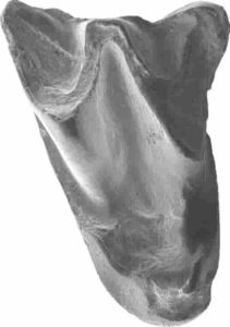
Hundreds of millions of years ago, in the middle of what would eventually become Canada’s Yukon Territory, an ocean swirled with armored trilobites, clam-like brachiopods and soft, squishy creatures akin to slugs and squid.

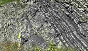
A trove of fossils and rock layers formed on that ancient ocean floor have now been unearthed by an international team of scientists along the banks of the Peel River a few hundred miles south of the Arctic’s Beaufort Sea. The discovery reveals oxygen changes at the seafloor across nearly 120 million years of the early Paleozoic era, a time that fostered the most rapid development and diversification of complex, multi-cellular life in Earth’s history.

“It’s unheard of to have that much of Earth’s history in one place,” said Stanford University geological scientist Erik Sperling, lead author of a July 7 study detailing the team’s findings in Science Advances. Most rock formations from the Paleozoic Era have been broken up by tectonic forces or eroded over time. “There’s nowhere else in the world that I know of where you can study that long a record of Earth history, where there’s basically no change in things like water depth or basin type.”

Oxygen was scarce in the deep water of this and other oceans at the dawn of the Paleozoic, roughly 541 million years ago. It stayed scarce until the Devonian, roughly 405 million years ago, when, in a geological blink — no more than a few million years — oxygen likely rocketed to levels close to those in modern oceans and the diversity of life on Earth exploded. Big, predatory fish appeared. Primitive ferns and conifers marched across continents previously ruled by bacteria and algae. Dragonflies took flight. And all of this after nearly four billion years of Earth’s landscapes being virtually barren.

Scientists have long debated what might have caused the dramatic shift from a low oxygen world to a more oxygenated one that could support a diverse web of animal life. But until now, it has been difficult to pin down the timing of global oxygenation or the long-term, background state of the world’s oceans and atmosphere during the era that witnessed both the so-called Cambrian explosion of life and the first of Earth’s “Big Five” mass extinctions, about 445 million years ago at the end of the Ordovician.

“In order to make comparisons throughout these huge swaths of our history and understand long-term trends, you need a continuous record,” said Sperling, an assistant professor of geological sciences at Stanford’s School of Earth, Energy & Environmental Sciences (Stanford Earth).

Context for past life

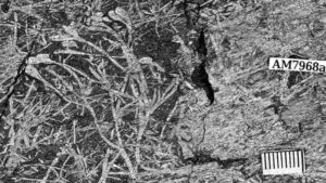
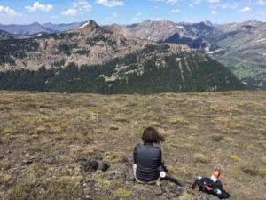
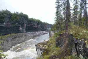
With permission from the Na Cho Nyak Dun and Tetlit Gwitch’in communities in Yukon, Sperling’s team, which included researchers from Dartmouth College and the Yukon Geological Survey, spent three summers at the Peel River site. Arriving by helicopter, the research team hacked through brush with machetes beside Class VI rapids to collect hundreds of fist-sized samples of rock from more than a mile of interbedded layers of shale, chert and lime mudstone.

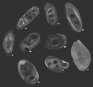
Back at Sperling’s lab at Stanford, a small army of summer undergraduates and graduate students worked over five summers to help analyze the fossils and chemicals entombed in the rocks. “We spent a lot of time splitting open rocks and looking at graptolite fossils,” Sperling said. Because graptolites evolved a vast array of recognizable body shapes relatively quickly, the pencil-like markings left by the fossils of these colony-dwelling sea creatures give geologists a way to date the rocks in which they’re found.

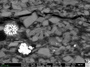
Once the researchers had finished identifying and dating graptolite fossils, they ground the rocks in a mill, then measured iron, carbon, phosphorus and other elements in the resulting powder to assess the ocean conditions at the time and place where the layers formed. They analyzed 837 new samples from the Peel River site, as well as 106 new samples from other parts of Canada and 178 samples from around the world for comparison.

Winners and losers

The data show low oxygen levels, or anoxia, likely persisted in the world’s oceans for millions of years longer than previously thought — well into the Phanerozoic, when land plants and early animals began to diversify. “The early animals were still living in a low oxygen world,” Sperling said. Contrary to long-held assumptions, the scientists found Paleozoic oceans were also surprisingly free of hydrogen sulfide, a respiratory toxin often found in the anoxic regions of modern oceans.

When oxygen eventually did tick upward in marine environments, it came about just as larger, more complex plant life took off. “There’s a ton of debate about how plants impacted the Earth system,” Sperling said. “Our results are consistent with a hypothesis that as plants evolved and covered the Earth, they increased nutrients to the ocean, driving oxygenation.” In this hypothesis, the influx of nutrients to the sea would have given a boost to primary productivity, a measure of how quickly plants and algae take carbon dioxide and sunlight, turn them into new biomass — and release oxygen in the process.

The change probably killed off graptolites. “Although more oxygen is really good for a lot of organisms, graptolites lost the low oxygen habitat that was their refuge,” Sperling said. “Any environmental change is going to have winners and losers. Graptolites might have been the losers.”

Reference:
Erik A. Sperling, Michael J. Melchin, Tiffani Fraser, Richard G. Stockey, Una C. Farrell, Liam Bhajan, Tessa N. Brunoir, Devon B. Cole, Benjamin C. Gill, Alfred Lenz, David K. Loydell, Joseph Malinowski, Austin J. Miller, Stephanie Plaza-Torres, Beatrice Bock, Alan D. Rooney, Sabrina A. Tecklenburg, Jacqueline M. Vogel, Noah J. Planavsky, Justin V. Strauss. A long-term record of early to mid-Paleozoic marine redox change. Science Advances, 2021; 7 (28): eabf4382 DOI: 10.1126/sciadv.abf4382

Note: The above post is reprinted from materials provided by Stanford University. Original written by Josie Garthwaite.

Researchers detail the most ancient bat fossil ever discovered in Asia

Upper molar of Altaynycteris aurora. Credit: Li Qiang

A new paper appearing in Biology Letters describes the oldest-known fragmentary bat fossils from Asia, pushing back the evolutionary record for bats on that continent to the dawn of the Eocene and boosting the possibility that the bat family’s “mysterious” origins someday might be traced to Asia.

A team based at the University of Kansas and China performed the fieldwork in the Junggar Basin — a very remote sedimentary basin in northwest China — to discover two fossil teeth belonging to two separate specimens of the bat, dubbed Altaynycteris aurora.

The new fossil specimens help scientists better understand bat evolution and geographic distribution and better grasp how mammals developed in general.

“Bats show up in the fossil record out of the blue about 55-ish million years ago — and they’re already scattered on different parts of the globe,” said lead author Matthew Jones, a doctoral student at the KU Biodiversity Institute and Department of Ecology & Evolutionary Biology. “Before this, the earliest bats are known from a couple of places in Europe — Portugal and southern France — and Australia. So, when they show up early in the fossil record as these fragmentary fossils they’re already effectively worldwide. By the time we get their earliest known full skeletons, they look modern — they can fly, and most of them are able to echolocate. But we don’t really know anything about this transitional period from non-bats to bats. We don’t even really know what their closest living relatives are among mammals. It’s a really big evolutionary mystery where bats came from and how they evolved and became so specialized.”

Jones’ co-authors were K. Christopher Beard, senior curator at the KU Biodiversity Institute and Foundation Distinguished Professor of Ecology & Evolutionary Biology at KU; and Qiang Li and Xijun Ni of the Key Laboratory of Vertebrate Evolution and Human Origins, Institute of Vertebrate Paleontology and Paleoanthropology at the Chinese Academy of Sciences and the Center for Excellence in Life and Paleoenvironment at the Chinese Academy of Sciences.

The ancient bat teeth were discovered through painstaking fieldwork in the Junggar Basin, where the KU researchers worked at an isolated field site established by their Chinese colleagues, one of two sites in the region the team hope will continue yielding interesting fossils.

“This was concerted effort over a long period of time by our Chinese colleagues,” Jones said.

“They suspected that there were fossiliferous deposits from the Paleocene and Eocene, and they spent several years going out there, identifying where to find fossils. Chris was a part of several seasons of fieldwork there. I was a part of one season of fieldwork there. What we did was collect a bunch of sediment to screen wash, which is sort of like panning for gold. You pour a bunch of sediment into a sievelike apparatus and let all the dirt and everything fall out, and you’re only left with particles of a certain size, but also fossils.”

Beard said the fieldwork was an outgrowth of long-standing relationships between the KU team and its Chinese counterparts.

“We’ve been fortunate enough to be able to host our Chinese colleagues here in Lawrence for extended research visits, and they’ve more than reciprocated by hosting us for research and fieldwork in China. This work in the Junggar Basin is really trailblazing work because the fossil record in this part of China is only just barely beginning to emerge, and this area is very removed and isolated. It’s just a giant empty place. There are some camels, some snakes and lizards, but you don’t see many people there. That remoteness makes the logistics to do fieldwork there quite difficult and expensive because you’ve got to bring in all your food and water from far outside — all of that hindered research in this area previously.”

Following the challenging fieldwork, the residue left behind from the screen washing at the site was sorted at the Institute of Vertebrate Paleontology and Paleoanthropology in Beijing.

“In 2017, after we got back from the field, Xijun said. ‘Hey, one of the technicians picking through this sediment thinks they found a bat,'” Jones said. “Knowing I was interested in bats, they showed it to me. The next year, the other tooth was found — so there’s two teeth.”

Through meticulous morphological analysis of the teeth, along with biostratigraphy — or analyzing the position of layers of fossil remains in the deposits — the authors were able to date the specimens to the advent of the Eocene, the earliest period when bat fossils have been found anywhere on Earth. Indeed, the presence of these ancient bat fossils in Asia bolsters a theory that bats could have emerged from there in the first place, then distributed themselves worldwide when they later developed flight.

More fieldwork in the area is ongoing, and Jones and Beard said they were hopeful to find even older specimens, perhaps even dating to the Paleocene, the epoch before the Eocene, when researchers believe bats probably originated. Yet the particulars of Altaynycteris aurora remain hazy — for instance, it’s impossible to say from teeth fragments if the animal could fly or echolocate.

“These teeth look intermediate, in between what we would expect a bat ancestor to look like — and in fact, what a lot of early Cenozoic insectivorous mammals to do look like — and what true bat looks like,” Jones said. “So, they have some features that are characteristic of bats that we can point to and say, ‘These are bats.’ But then they have some features that we can call for simplicity’s sake ‘primitive.'”

The researchers said the new fossils help fill in a gap to understanding the evolution of bats, which remains a puzzle to experts — and could teach us more about mammals in general.

“I can think of two mammal groups that are alive today that are really weird,” Beard said. “One of them is bats, because they fly — and that’s just ridiculous. The other one is whales, because they’re completely adapted to life in the ocean, they can swim, obviously, and they do a little bit of sonar echolocation themselves. We know a lot about transitional fossils for whales. There are fossils from places like Pakistan that were quadrupedal mammals that looked vaguely doglike. We have a whole sequence of fossils linking these things that were clearly terrestrial animals walking around on land, through almost every kind of transitional phase you can imagine, to a modern whale. This isn’t true for bats. For bats, literally you’ve got a normal mammal and then you’ve got bats — and anytime you’ve got a fossil record that’s a giant vacuum, we need work that can fill partly that. This paper is at least a step along that path.”

Reference:
Matthew F. Jones, Qiang Li, Xijun Ni, K. Christopher Beard. The earliest Asian bats (Mammalia: Chiroptera) address major gaps in bat evolution. Biology Letters, 2021; 17 (6): 20210185 DOI: 10.1098/rsbl.2021.0185

Note: The above post is reprinted from materials provided by University of Kansas.

Earth’s climate life story, 3 billion years in the making

Boriana Kalderon-Asael conducts field work at a Middle-Upper Ordovician outcrop near Reedsville, Penn. Credit: Ashleigh Hood

One of Earth’s greatest mysteries is how it transformed itself, ever so gradually, from a barren ball of rock into a launching pad for life.

Earth scientists have spent decades piecing together the relevant clues—identifying and studying the planet’s complex interplay of geological processes, atmospheric dynamics, and chemical cycles. In particular, scientists have studied the roles played by carbon and silicon in stabilizing Earth’s climate over a vast stretch of time.

Now a Yale-led study in the journal Nature provides an unprecedented look at this 3-billion-year-old story, told in ancient sediments from around the world.

“We wanted to advance our understanding of what processes have regulated Earth’s climate over geologic time scales,” said Noah Planavsky, an associate professor of Earth and planetary sciences in Yale’s Faculty of Arts and Sciences and co-corresponding author of the new study with Yale graduate student Boriana Kalderon-Asael and University College London researcher Philip Pogge von Strandmann.

“How the Earth’s climate has remained stable for the majority of the last 3 billion years is one of the most fundamental questions one can ask about how the Earth works,” Planavsky said.

At the root of Earth’s climate life story is its ability to remove carbon dioxide from the atmosphere and store it in rocks and sediments. We have plants to thank for that, the researchers said.

The emergence of plants on land and in the ocean led to gradual—but major—changes in how rocks and sediments weathered. These changes in weathering opened the door for sequestering carbon into the Earth itself.

“The result was a substantial decrease in carbon dioxide levels, which kept pace with the increasing luminosity of the sun as it aged, helping to ensure that the Earth remained persistently habitable to both simple and complex life forms,” Planavsky said.

Kalderon-Asael and Planavsky led an international team of researchers that gathered more than 600 sediment samples at roughly 100 sites worldwide. The researchers studied geochemical data found in lithium isotopes in the samples—a methodology used in other studies over the past decade to look at specific points in Earth’s recent and distant past.

The new study encompasses the entirety of Earth’s history, allowing researchers to document the evolution of how Earth regulated its climate.

“It gives us the whole picture,” said Kalderon-Asael, the study’s first author. “This began as a one-year project to look at a couple of sites. As we started to see the data come in, we added more collaborators and more samples until we were able to look at all of Earth’s history.”

In addition to the history lesson, the study offers a long-term perspective on the rapid changes in global climate today.

“Through all of the massive changes Earth has undergone—in the biosphere and in the amount of solar radiation it receives—it has remained habitable by making adjustments on extremely long time-scales,” Planavsky said. “It highlights how totally unprecedented the current shifts are in the carbon cycle.”

Reference:
Boriana Kalderon-Asael et al, A lithium-isotope perspective on the evolution of carbon and silicon cycles, Nature (2021). DOI: 10.1038/s41586-021-03612-1

Note: The above post is reprinted from materials provided by Yale University.

A rock with many perspectives

The Alum Shale, here an example of a coastal deposit, consists of quartz and potassium Feldspar clasts as well as conspicuous Pyrite crystals (here: white) embedded in a clayey matrix. Scanning electron micrograph (scale: lower image edge length corresponds to approx. 40 μm). Credit: Schulz, GFZ

The Alum Shale of Northern Europe not only has an eventful history of formation, connected with the microcontinent Baltica, it also holds great potential as an object of investigation for future research questions. Geologists use the rock to reconstruct processes of oil and gas formation, and even possible traces of past life on Mars can be identified with its help. Researchers at the German Research Centre for Geosciences Potsdam GFZ, together with colleagues from Canada, China, Switzerland and Denmark, have summarized the state of knowledge about the multi-layered rock. Their article was published in July in the journal Earth-Science Reviews.

The microcontinent ‘Baltica’

“This rock tells a story,” says Hans-Martin Schulz when he talks about the Northern European Alum Shale. It is the checkered history of a microcontinent called “Baltica”, which was located in the southern hemisphere about 500 million years ago. “The microcontinent is surrounded by a calm, shallow marginal sea,” says the scientist in the GFZ’s Organic Geochemistry Section, describing the situation in the period from the Middle Cambrian to the Lower Ordovician. Higher land plants do not yet exist, and the surface of Baltica is exposed to wind and weather. “Rocks weather, and debris and dust are carried into the sea. Together with components of algae and other microorganisms, they trickle through the layers of the calm marginal sea and settle layer by layer in the oxygen-free bottom water,” Schulz continues. These organic-mineral deposits fossilize and form the dark claystone that makes up today’s Alum Shale. Over millions of years, Baltica migrated northwards and is now integrated into northern Europe. “Almost half a billion years later, the Baltic Sea forms on Baltica,” Schulz concludes the first part of the story.

Oil and gas formation in phases

For three years, Schulz’s group and international colleagues have been combing through their own data and that of other research groups. In their comprehensive synopsis, they also describe the different phases of oil and gas formation during Baltica’s development. Parts of the microcontinent sink to depths of several thousand meters during migration. Oil forms under the influence of geothermal heat. “The oil that was generated at that time is now produced on the Swedish island of Gotland and in the Baltic Sea off the Polish coast,” Schulz explains.

Other parts of the microcontinent occur more near the surface, for example in what is now southern Sweden. There, about 300 million years ago, increased expansion of the earth’s crust takes place. Magma escapes, the heat of which causes further crude oil to form in the Alum Shale. “These rather regional deposits are enclosed in the rock,” the geologist describes. At the end of the last ice age, about ten thousand years ago, sweet meltwater penetrates the shale here. “It meets tiny inclusions of ancient seawater. They contain bacteria that have survived for millions of years,” Schulz describes. The fresh water awakens them to new activity, and further bacteria are possibly contained in the meltwater. The microbes decompose components of the oil and form methane gas.

Influence of uranium

And that’s not the end of the story: although there is still plenty of organic material, the oil-forming potential of the Alum Shale is declining. This is because it contains uranium, whose radiation alters the enclosed carbon compounds over long periods of time—”with fatal consequences for oil formation”, as Schulz says. “The long chains are split off,” he explains. “What remains are ring-shaped hydrocarbons, predominantly benzene rings, which are linked together.” These changes prevent the further formation of petroleum from the organic remnants of Cambrian and Ordovician life. The uranium probably originated in the rocks that were eroded on Baltica and settled in the sea. “And seawater also contains dissolved uranium, so some of the radioactive metal could have been absorbed by the sediments from it,” Schulz adds.

Alum shale has many talents

The GFZ researcher and his team are investigating the significance of the very high uranium concentrations in places in the Alum Shale: “Can organic material altered by uranium still feed a deep biosphere?” they are asking themselves in ongoing studies, for example. Or does the radioactive fission of hydrocarbons prevent microbes from surviving at great depths? And it is not only the influence of uranium on microbial life that interests him. “The Alum Shale is a rock with many talents,” Schulz says. “We can study numerous processes on it at different depths, at different degrees of maturity of the organic material, different uranium concentrations and sometimes extreme conditions.”

The Alum Shale may even have answers to the question of past life at a distance of 70 million kilometers from Earth: organic components have been found on Mars that have structural similarities to those found in the Alum Shale. And similar to the uranium-containing terrestrial mudstone, these molecules were exposed to the equally radioactive cosmic over long periods of time. “So these hydrocarbon compounds could be the altered remains of organisms similar to our earlier bacteria,” Schulz explains. “The Alum Shale serves as a Mars analog for us to interpret the possible traces of past life on our neighboring planet.”

Insights into final disposal of nuclear waste?

For us on Earth, another aspect of his research is topical: besides salts and granites, mudstone is a candidate for the final disposal of nuclear waste. “We also have ideas for future projects on this,” Schulz reveals. “At the core of this is the question of microbial life over long periods of time in the low-porosity, uranium-rich Alum Shale—but that story is on another page.”

Reference:
Hans-Martin Schulz et al, The Furongian to Lower Ordovician Alum Shale Formation in conventional and unconventional petroleum systems in the Baltic Basin – A review, Earth-Science Reviews (2021). DOI: 10.1016/j.earscirev.2021.103674

Note: The above post is reprinted from materials provided by Helmholtz Association of German Research Centres.

‘Fool’s gold’ not so foolish after all

Gold in pyrite
Gold in pyrite

Curtin University research has found tiny amounts of gold can be trapped inside pyrite, commonly known as ‘fool’s gold’, which would make it much more valuable than its name suggests.

This study, published in the journal Geology in collaboration with the University of Western Australia and the China University of Geoscience, provides an in-depth analysis to better understand the mineralogical location of the trapped gold in pyrite, which may lead to more environmentally friendly gold extraction methods.

Lead researcher Dr Denis Fougerouse from Curtin’s School of Earth and Planetary Sciences said this new type of “invisible” gold has not previously been recognised and is only observable using a scientific instrument called an atom probe.

“The discovery rate of new gold deposits is in decline worldwide with the quality of ore degrading, parallel to the value of precious metal increasing,” Dr Fougerouse said.

“Previously gold extractors have been able to find gold in pyrite either as nanoparticles or as a pyrite-gold alloy, but what we have discovered is that gold can also be hosted in nanoscale crystal defects, representing a new kind of “invisible” gold.

“The more deformed the crystal is, the more gold there is locked up in defects. The gold is hosted in nanoscale defects called dislocations — one hundred thousand times smaller than the width of a human hair — so a special technique called atom probe tomography is needed to observe it.”

Dr Fougerouse said the team also explored gold extraction methods and possible ways to obtain the trapped gold with less adverse impacts on the environment.

“Generally, gold is extracted using pressure oxidizing techniques (similar to cooking), but this process is energy hungry. We wanted to look into an eco-friendlier way of extraction,” Dr Fougerouse said.

“We looked into an extraction process called selective leaching, using a fluid to selectively dissolve the gold from the pyrite. Not only do the dislocations trap the gold, but they also behave as fluid pathways that enable the gold to be “leached” without affecting the entire pyrite.”

The study is supported by the Australian Research Council and the Science and Industry Endowment Fund. Dr Fougerouse is affiliated with The Institute for Geoscience Research (TIGeR), Curtin’s flagship Earth Sciences research institute.

Reference:
Denis Fougerouse, Steven M. Reddy, Mark Aylmore, Lin Yang, Paul Guagliardo, David W. Saxey, William D.A. Rickard, Nicholas Timms. A new kind of invisible gold in pyrite hosted in deformation-relateddislocations. Geology, 2021; DOI: 10.1130/G49028.1

Note: The above post is reprinted from materials provided by Curtin University.

Earth’s meteorite impacts over past 500 million years tracked

The asteroid belt between Jupiter and Mars is the main source of extraterrestrial material that lands on Earth. (Illustration: ESA/ATG Medialab)

For the first time, a unique study conducted at Lund University in Sweden has tracked the meteorite flux to Earth over the past 500 million years. Contrary to current theories, researchers have determined that major collisions in the asteroid belt have not generally affected the number of impacts with Earth to any great extent.

Researchers have been studying geological series since the 19th century in order to reconstruct how flora, fauna and the climate have changed over millions of years. Until now, however, almost nothing has been known about ancient meteorite flux — which makes sense since impact is rare, and the battered celestial bodies quickly break down as they encounter Earth’s oxygen. A new study published in PNAS shows how researchers in Lund have reconstructed meteorite bombardment towards Earth over the past 500 million years.

“The research community previously believed that meteorite flux to Earth was connected to dramatic events in the asteroid belt. The new study, however, shows that the flux has instead been very stable,” says Birger Schmitz, professor of geology at Lund University.

To conduct the study, researchers at Lund University’s Astrogeobiology Laboratory dissolved almost ten tonnes of sedimentary rocks from ancient seabeds in strong acids because the sediment contains residue from the meteorites dating back to when they fell to Earth.

Meteorites contain a small fraction of a mineral, a chromium oxide, which is very resistant to degradation. The microscopic chromium oxide grains were sifted out in the laboratory and serve as time capsules with an abundance of information.

“The dissolved sediment represents 15 periods over the past 500 million years. In total, we have extracted chromium oxide from almost 10,000 different meteorites. Chemical analyses then enabled us to determine which types of meteorites the grains represent,” says Birger Schmitz.

A couple of thousand meteorites land on the Earth’s surface every year, and approximately 63,000 space rocks have been documented by science. The space rocks originate from the asteroid belt between Mars and Jupiter where battered celestial bodies from gigantic collisions revolve around the sun.

“We were very surprised to learn that only one of the 70 largest asteroid collisions that took place over the past 500 million years resulted in an increased flux of meteorites to Earth. For some reason, most of the rocks stay in the asteroid belt,” says Birger Schmitz.

The study not only upends generally accepted meteorite flux theories; it also provides entirely new perspectives on which types of celestial bodies are at greatest risk of colliding with Earth and where in the solar system they originate. From a geological time perspective, kilometre-sized celestial bodies collide with the Earth on a regular basis. One such event took place 66 million years ago, when a celestial body stretching over 10 kilometres in size hit the Yucatán Peninsula. The impact was part of the reason the Earth went dark and dinosaurs starved to death.

“Future impact from even a small asteroid for example in the sea close to a populated area could lead to disastrous outcomes. This study provides important understanding that we can use to prevent this from happening; for example, by attempting to influence the trajectory of rapidly approaching celestial bodies,” concludes Birger Schmitz.

Reference:
Fredrik Terfelt, Birger Schmitz. Asteroid break-ups and meteorite delivery to Earth the past 500 million years. Proceedings of the National Academy of Sciences, 2021; 118 (24): e2020977118 DOI: 10.1073/pnas.2020977118

Note: The above post is reprinted from materials provided by Lund University.

Discovery of the oldest plant fossils on the African continent!

 Uskiella spargen a small plant whose axes divide several times before bearing oval sporangia. Credit : Cyrille Prestianni
Uskiella spargen a small plant whose axes divide several times before bearing oval sporangia. Credit : Cyrille Prestianni

The analysis of very old plant fossils discovered in South Africa and dating from the Lower Devonian period documents the transition from barren continents to the green planet we know today. Cyrille Prestianni, a palaeobotanist at the EDDy Lab at the University of Liège (Belgium), participated in this study, the results of which have just been published in the journal Scientific Reports.

The greening of continents — or terrestrialisation — is undoubtedly one of the most important processes that our planet has undergone. For most of the Earth’s history, the continents were devoid of macroscopic life, but from the Ordovician period (480 million years ago) green algae gradually adapted to life outside the aquatic environment. The conquest of land by plants was a very long process during which plants gradually acquired the ability to stand upright, breathe in the air or disperse their spores. Plant fossils that document these key transitions are very rare. In 2015, during the expansion of the Mpofu Dam (South Africa), researchers discovered numerous plant fossils in geological strata dated to the Lower Devonian (420 — 410 million years ago), making this a truly exceptional discovery.

Cyrille Prestianni, a palaeobotanist at the EDDy Lab (Evolution and Diversity Dynamics Lab) at the University of Liège, explains: “The discovery quickly proved to be extraordinary, since we are in the presence of the oldest fossil flora in Africa and it is very diversified and of exceptional quality. It is thanks to a collaboration between the University of Liège, the IRSNB (Royal Belgian Institute of Natural Sciences) and the New Albany Museum (South Africa) that this incredible discovery could be studied. The study, which has just been published in the journal Scientific Reports, describes this particularly diverse fossil flora with no less than fifteen species analysed, three of which are new to science. Dr. Prestianni adds : ” This flora is also particularly interesting because of the quantity of complete specimens that have been discovered,” says the researcher. These plants are small, with the largest specimens not exceeding 10 cm in height. They are simple plants, consisting of axes that divide two or three times and end in reproductive structures called sporangia. ”

The fossil flora of Mpofu allows us today to imagine what the world might have been like when the largest plants were no taller than our ankle and almost no animals had yet been able to free themselves from the aquatic environment. It gives us a better understanding of how our Earth went from a red rock devoid of life to the green planet we know today. These plants, simple as they are, are a crucial step in the construction of the environments that hosted the first land animals, arthropods. They form the basis of the long history of life on Earth, which continues today from dense tropical forests to the arid tundra of the north.

Reference:
Robert W. Gess, Cyrille Prestianni. An early Devonian flora from the Baviaanskloof Formation (Table Mountain Group) of South Africa. Scientific Reports, 2021; 11 (1) DOI: 10.1038/s41598-021-90180-z

Note: The above post is reprinted from materials provided by University of Liege.

The Earth has a pulse — a 27.5-million-year cycle of geological activity, researchers say

The early Earth was hotter than it is today and this affected the strength of the crust and mantle.

Geologic activity on Earth appears to follow a 27.5-million-year cycle, giving the planet a “pulse,” according to a new study published in the journal Geoscience Frontiers.

“Many geologists believe that geological events are random over time. But our study provides statistical evidence for a common cycle, suggesting that these geologic events are correlated and not random,” said Michael Rampino, a geologist and professor in New York University’s Department of Biology, as well as the study’s lead author.

Over the past five decades, researchers have proposed cycles of major geological events — including volcanic activity and mass extinctions on land and sea — ranging from roughly 26 to 36 million years. But early work on these correlations in the geological record was hampered by limitations in the age-dating of geologic events, which prevented scientists from conducting quantitative investigations.

However, there have been significant improvements in radio-isotopic dating techniques and changes in the geologic timescale, leading to new data on the timing of past events. Using the latest age-dating data available, Rampino and his colleagues compiled updated records of major geological events over the last 260 million years and conducted new analyses.

The team analyzed the ages of 89 well-dated major geological events of the last 260 million years. These events include marine and land extinctions, major volcanic outpourings of lava called flood-basalt eruptions, events when oceans were depleted of oxygen, sea-level fluctuations, and changes or reorganization in the Earth’s tectonic plates.

They found that these global geologic events are generally clustered at 10 different timepoints over the 260 million years, grouped in peaks or pulses of roughly 27.5 million years apart. The most recent cluster of geological events was approximately 7 million years ago, suggesting that the next pulse of major geological activity is more than 20 million years in the future.

The researchers posit that these pulses may be a function of cycles of activity in the Earth’s interior — geophysical processes related to the dynamics of plate tectonics and climate. However, similar cycles in the Earth’s orbit in space might also be pacing these events.

“Whatever the origins of these cyclical episodes, our findings support the case for a largely periodic, coordinated, and intermittently catastrophic geologic record, which is a departure from the views held by many geologists,” explained Rampino.

In addition to Rampino, study authors include Yuhong Zhu of NYU’s Center for Data Science and Ken Caldeira of the Carnegie Institution for Science.

Reference:
Michael R. Rampino, Ken Caldeira, Yuhong Zhu. A pulse of the Earth: A 27.5-Myr underlying cycle in coordinated geological events over the last 260 Myr. Geoscience Frontiers, 2021; 12 (6): 101245 DOI: 10.1016/j.gsf.2021.101245

Note: The above post is reprinted from materials provided by New York University.

Mining precious rare-earth elements from coal fly ash with a reusable ionic liquid

Open cut hard rock mining, Kalgoorlie, Western Australia.
Open cut hard rock mining, Kalgoorlie, Western Australia. Credit: Stephen Codrington

Rare-earth elements are in many everyday products, such as smart phones, LED lights and batteries. However, only a few locations have large enough deposits worth mining, resulting in global supply chain tensions. So, there’s a push toward recycling them from non-traditional sources, such as waste from burning coal — fly ash. Now, researchers in ACS’ Environmental Science & Technology report a simple method for recovering these elements from coal fly ash using an ionic liquid.

While rare-earth elements aren’t as scarce as their name implies, major reserves are either in politically sensitive locations, or they are widely dispersed, which makes mining them challenging. So, to ensure their supply, some people have turned to processing other enriched resources. For instance, the ash byproduct from coal-fired power plants has similar elemental concentrations to raw ores. Yet, current methods to extract these precious materials from coal fly ash are hazardous and require several purification steps to get a usable product. A potential solution could be ionic liquids, which are considered to be environmentally benign and are reusable. One in particular, betainium bis(trifluoromethylsulfonyl)imide or [Hbet][Tf2N], selectively dissolves rare-earth oxides over other metal oxides. This ionic liquid also uniquely dissolves into water when heated and then separates into two phases when cooled. So, Ching-Hua Huang, Laura Stoy and colleagues at Georgia Tech wanted to see if it would efficiently and preferentially pull the desired elements out of coal fly ash and whether it could be effectively cleaned, creating a process that is safe and generates little waste.

The researchers pretreated coal fly with an alkaline solution and dried it. Then, they heated ash suspended in water with [Hbet][Tf2N], creating a single phase. When cooled, the solutions separated. The ionic liquid extracted more than 77% of the rare-earth elements from fresh material, and it extracted an even higher percentage (97%) from weathered ash that had spent years in a storage pond. Finally, rare-earth elements were stripped from the ionic liquid with dilute acid. The researchers found that adding betaine during the leaching step increased the amounts of rare-earth elements extracted. The team tested the ionic liquid’s reusability by rinsing it with cold water to remove excess acid, finding no change in its extraction efficiency through three leaching-cleaning cycles. The researchers say that this low-waste approach produces a solution rich in rare-earth elements, with limited impurities, and could be used to recycle precious materials from the abundance of coal fly ash held in storage ponds.

Reference:
Laura Stoy, Victoria Diaz, Ching-Hua Huang. Preferential Recovery of Rare-Earth Elements from Coal Fly Ash Using a Recyclable Ionic Liquid. Environmental Science & Technology, 2021; DOI: 10.1021/acs.est.1c00630

Note: The above post is reprinted from materials provided by American Chemical Society.

Earth-like biospheres on other planets may be rare

An artistic representation of the potentially habitable planet Kepler 422-b (left), compared with Earth (right). Credit: Ph03nix1986 / Wikimedia Commons
An artistic representation of the potentially habitable planet Kepler 422-b (left), compared with Earth (right).
Credit: Ph03nix1986 / Wikimedia Commons

A new analysis of known exoplanets has revealed that Earth-like conditions on potentially habitable planets may be much rarer than previously thought. The work focuses on the conditions required for oxygen-based photosynthesis to develop on a planet, which would enable complex biospheres of the type found on Earth. The study is published today in Monthly Notices of the Royal Astronomical Society.

The number of confirmed planets in our own Milky Way galaxy now numbers into the thousands. However planets that are both Earth-like and in the habitable zone — the region around a star where the temperature is just right for liquid water to exist on the surface — are much less common.

At the moment, only a handful of such rocky and potentially habitable exoplanets are known. However the new research indicates that none of these has the theoretical conditions to sustain an Earth-like biosphere by means of ‘oxygenic’ photosynthesis — the mechanism plants on Earth use to convert light and carbon dioxide into oxygen and nutrients.

Only one of those planets comes close to receiving the stellar radiation necessary to sustain a large biosphere: Kepler-442b, a rocky planet about twice the mass of the Earth, orbiting a moderately hot star around 1,200 light years away.

The study looked in detail at how much energy is received by a planet from its host star, and whether living organisms would be able to efficiently produce nutrients and molecular oxygen, both essential elements for complex life as we know it, via normal oxygenic photosynthesis.

By calculating the amount of photosynthetically active radiation (PAR) that a planet receives from its star, the team discovered that stars around half the temperature of our Sun cannot sustain Earth-like biospheres because they do not provide enough energy in the correct wavelength range. Oxygenic photosynthesis would still be possible, but such planets could not sustain a rich biosphere.

Planets around even cooler stars known as red dwarfs, which smoulder at roughly a third of our Sun’s temperature, could not receive enough energy to even activate photosynthesis. Stars that are hotter than our Sun are much brighter, and emit up to ten times more radiation in the necessary range for effective photosynthesis than red dwarfs, however generally do not live long enough for complex life to evolve.

“Since red dwarfs are by far the most common type of star in our galaxy, this result indicates that Earth-like conditions on other planets may be much less common than we might hope,” comments Prof. Giovanni Covone of the University of Naples, lead author of the study.

He adds: “This study puts strong constraints on the parameter space for complex life, so unfortunately it appears that the “sweet spot” for hosting a rich Earth-like biosphere is not so wide.”

Future missions such as the James Webb Space Telescope (JWST), due for launch later this year, will have the sensitivity to look to distant worlds around other stars and shed new light on what it really takes for a planet to host life as we know it.

Reference:
Giovanni Covone, Riccardo M Ienco, Luca Cacciapuoti, Laura Inno. Efficiency of the oxygenic photosynthesis on Earth-like planets in the habitable zone. Monthly Notices of the Royal Astronomical Society, 2021; 505 (3): 3329 DOI: 10.1093/mnras/stab1357

Note: The above post is reprinted from materials provided by Royal Astronomical Society.

Analysing volcanoes to predict their awakening

One of the strombolian explosions that have occurred at Stromboli about every 10 minutes for at least 2000 years. © UNIGE, Luca Caricchi

What causes an eruption? Why do some volcanoes erupt regularly, while others remain dormant for thousands of years? A team of geologists and geophysicists, led by the University of Geneva (UNIGE), Switzerland, has reviewed the literature on the internal and external mechanisms that lead to a volcanic eruption. Analyzing the thermo-mechanics of deep volcanic processes and magma propagation to the surface, together with magma chemistry, the geologists determined that most of the magma rising from depth actually does not cause a volcanic eruption. They also show that older volcanoes tend to produce less frequent, but larger and more dangerous eruptions. Their findings, published in Nature Reviews Earth and Environment, will help refine models of volcanic processes to reduce the impact of volcanic eruptions on the more than 800 million people living near active volcanoes.

Volcanic activity remains difficult to predict even when it is closely monitored. Why didn’t Mount Fuji erupt after the strong earthquake in Tohoku, Japan? Why did the eruption of Eyjafjallajökul generate such a large amount of volcanic ash? In order to determine the causes of volcanic eruptions, geologists and geophysicists led by Luca Caricchi, professor at the Department of Earth Sciences of the Faculty of Science of the UNIGE, have taken up the existing literature and analysed all the stages that precede an eruption.

The path of magma from the depths of the Earth

Magma is molten rock that comes from tens of kilometres depth and rises to the Earth’s surface. “During its journey, magma can get trapped in reservoirs within the Earth’s crust, where it may stagnate for thousands of years and potentially never erupt,” explains Meredith Townsend, a researcher at the Department of Earth Sciences of the University of Oregon (USA). Specialising in thermomechanical modelling, the American researcher focused on calculating the pressure required for the magma to break up the rocks surrounding the reservoir and rise to the surface. Eleonora Rivalta, a researcher at the Potsdam Research Centre for Geosciences (Germany) and the University of Bologna (Italy), studied the propagation of magma as it rises to the surface: “If it is runny enough, that is if it does not contain too many crystals, magma can rise very quickly by a sort of self-propelled fracking,” she continues. If magma crystallises more than 50%, it becomes too viscous and its march towards the surface stops. Magma can also take different paths, vertical, horizontal or inclined. Luca Caricchi specialises in magma chemistry, which provides vital information about the state of the magma before a volcanic eruption occurs. “The chemistry of magma and the crystals it contains provide vital information on the sequence of events leading to a volcanic eruption, which is valuable to better interpret the monitoring signals of active volcanoes and anticipate- whether an eruption might occur,” explains the Geneva-based researcher. Finally, Atsuko Namiki, a researcher at the Graduate School of Environmental Studies at Nagoya University (Japan), has analysed the external triggers of an eruption, such as earthquakes, tides or rain: “These alone cannot cause an eruption, the magma has to be ready and awaiting a trigger.”

“For an eruption to take place, several conditions must be met simultaneously. Magma with less than 50% crystals must be stored in a reservoir,” begins Luca Caricchi. Then this reservoir must be overpressurised. The overpressure can be the result of internal phenomena such as a renewed injection of magma or the exsolution of magmatic gases or it can rise to critical values because of external events such as earthquakes. Finally, once the pressure is sufficient for the magma to start rising, there are still many obstacles that can prevent the magma from erupting.

The age of the volcano as a primary criterion

This comprehensive analysis sheds a light on the behaviour of volcanoes that can change over their lifetime. “When a volcano is just starting to be active, its reservoir is rather small (a few km3) and the surrounding crust is relatively cold, which leads to many frequent, but small and rather predictable eruptions,” explains Luca Caricchi. It’s a different story with old volcanoes. “Their reservoir is bigger and the rocks around them are hotter. When new magma is injected, it does not generate much overpressure because the rocks around the reservoir deform and the growth continues,” says the geologist. As an example Mt St Helens (USA) started erupting 40’000 years ago (a time lapse by geological standards) and its last eruption in 2008 was small and not dangerous. On the contrary, Toba (Indonesia) started erupting explosively about 1.2 million years ago and its last eruption 74000 years ago was cataclysmic. It totally destroyed the surroundings and had an impact on global climate.

Eventually, the accumulation of large amounts of magma will lead to large eruptions. “Moreover, the warning signs are very difficult to detect because the high temperatures decrease seismic activity and the interaction between gases and magma modifies their composition, making it harder to understand what is going on underneath,” he says. The higher the rate of magma input, the faster the volcano ‘ages’.

Knowing the age of the volcano, which can be dated by analysing the zircon in the rocks, allows geologists to understand the stage of life of the volcanoes. “There are currently 1,500 active volcanoes, and about 50 of them erupt each year. Knowing whether or not to evacuate the population is crucial and we hope that our study will contribute to decrease the impact of volcanic activity on our society,” continues Luca Caricchi. “Hopefully our findings will be tested on volcanoes that have been studied extensively, such as those in Italy, USA and Japan, and transferred to other volcanoes for which there are less data, such as in Indonesia or South America.”

Reference:
Luca Caricchi, Meredith Townsend, Eleonora Rivalta, Atsuko Namiki. The build-up and triggers of volcanic eruptions. Nature Reviews Earth & Environment, 2021; DOI: 10.1038/s43017-021-00174-8

Note: The above post is reprinted from materials provided by Université de Genève.

Environmental impact of hydrofracking vs. conventional gas/oil drilling: Research shows the differences may be minimal

A new study led by A&S professor Tao Wen used a novel method of machine learning to explore the environmental impact of oil and gas drilling.

Crude oil production and natural gas withdrawals in the United States have lessened the country’s dependence on foreign oil and provided financial relief to U.S. consumers, but have also raised longstanding concerns about environmental damage, such as groundwater contamination.

A researcher in Syracuse University’s College of Arts and Sciences, and a team of scientists from Penn State, have developed a new machine learning technique to holistically assess water quality data in order to detect groundwater samples likely impacted by recent methane leakage during oil and gas production. Using that model, the team concluded that unconventional drilling methods like hydraulic fracturing — or hydrofracking — do not necessarily incur more environmental problems than conventional oil and gas drilling.

The two common ways to extract oil and gas in the U.S. are through conventional and unconventional methods. Conventional oil and gas are pumped from easily accessed sources using natural pressure. Conversely, unconventional oil and gas are acquired from hard-to-reach sources through a combination of horizontal drilling and hydraulic fracturing. Hydrofracking extracts natural gas, petroleum and brine from bedrock formations by injecting a mixture of sand, chemicals and water. By drilling into the earth and directing the high-pressure mixture into rock, the gas inside releases and flows out to the head of a well.

Tao Wen, assistant professor of earth and environmental sciences (EES) at Syracuse, recently led a study comparing data from different states to see which method might result in greater contamination of groundwater. They specifically tested levels of methane, which is the primary component of natural gas.

The team selected four U.S. states located in important shale zones to target for their study: Pennsylvania, Colorado, Texas and New York. One of those states — New York — banned the practice of hydrofracking in 2015 following a review by the NYS Department of Health which found significant uncertainties about health, including increased water and air pollution.

Wen and his colleagues compiled a large groundwater chemistry dataset from multiple sources including federal agency reports, journal articles, and oil and gas companies. The majority of tested water samples in their study were collected from domestic water wells. Although methane itself is not toxic, Wen says that methane contamination detected in shallow groundwater could be a risk to the relevant homeowner as it could be an explosion hazard, could increase the level of other toxic chemical species like manganese and arsenic, and would contribute to global warming as methane is a greenhouse gas.

Their model used sophisticated algorithms to analyze almost all of the retained geochemistry data in order to predict if a given groundwater sample was negatively impacted by recent oil and gas drilling.

The data comparison showed that methane contamination cases in New York — a state without unconventional drilling but with a high volume of conventional drilling — were similar to that of Pennsylvania — a state with a high volume of unconventional drilling. Wen says this suggests that unconventional drilling methods like fracking do not necessarily lead to more environmental problems than conventional drilling, although this result might be alternatively explained by the different sizes of groundwater chemistry datasets compiled for these two states.

The model also detected a higher rate of methane contamination cases in Pennsylvania than in Colorado and Texas. Wen says this difference could be attributed to different practices when drillers build/drill the oil and gas wells in different states. According to previous research, most of the methane released into the environment from gas wells in the U.S. occurs because the cement that seals the well is not completed along the full lengths of the production casing. However, no data exists to conclude if drillers in those three states use different technology. Wen says this requires further study and review of the drilling data if they become available.

According to Wen, their machine learning model proved to be effective in detecting groundwater contamination, and by applying it to other states/counties with ongoing or planned oil and gas production it will be an important resource for determining the safest methods of gas and oil drilling.

Wen and his colleagues from Penn State, including Mengqi Liu, a graduate student from the College of Information Sciences and Technology, Josh Woda, a graduate student from Department of Geosciences, Guanjie Zheng, former Ph.D. student from the College of Information Sciences and Technology, and Susan L. Brantley, distinguished professor in the Department of Geosciences and director of Earth and Environmental Systems Institute, recently had their findings published in the journal Water Research.

The team’s work was funded by National Science Foundation IIS-16-39150, US Geological Survey (104b award G16AP00079), and College of Earth and Mineral Sciences Dean’s Fund for Postdoc-Facilitated Innovation at Penn State.

Reference:
Tao Wen, Mengqi Liu, Josh Woda, Guanjie Zheng, Susan L. Brantley. Detecting anomalous methane in groundwater within hydrocarbon production areas across the United States. Water Research, 2021; 200: 117236 DOI: 10.1016/j.watres.2021.117236

Note: The above post is reprinted from materials provided by Syracuse University. Original written by Dan Bernardi.

Continuous activity of small earthquakes makes mountains grow

In the time between mega-earthquakes, smaller earthquakes continuously occur between oceanic and continental plates (background earthquakes). Where a lot of energy is released through these earthquakes, we observe coastal mountains that rise faster. In contrast, slow-uplifting coastal areas coincide with fewer background earthquakes. Credit: University of Tübingen

From a human perspective, earthquakes are natural disasters—in the past hundred years, they have caused more than 200,000 deaths and enormous economic damage. Mega-earthquakes with a magnitude of nine or higher on the Richter scale are considered a particular threat. Yet the inconceivable energy released in these events doesn’t seem to affect the uplift of mountains, according to a new study by geoscientists at the University of Tübingen. The energy of small earthquakes that work steadily in the background appears to play a far greater role in shaping the landscape. In Chile and Japan, Professor Todd Ehlers and Dr. Andrea Madella found parallels between seismic activity and the pattern and rate of mountain uplift. The results have been published in the journal Nature Geoscience.

Earthquakes generally occur in areas of the Earth where continental plates collide. Along the Chilean coast, for example, the Nazca plate is being pushed under the South American plate, causing the latter to be compressed and to accumulate elastic energy over hundreds of years. “The discharge of all that energy within a short time—often less than a minute—results in mega-earthquakes which can shake the ground in a terrifying way,” says Todd Ehlers, “and in that time, the oceanic Nazca plate slides under the continental one.”

Mountain ranges are pushed up at the edge of the compressed plate. In Peru and Chile, these are the Andes, which reach heights of more than 6,900 meters. In Japan, where several continental plates collide, mountains form a large part of the land mass.

Surprising patterns

In their study, the researchers examined records of earthquakes of various magnitudes along the fault lines in Chile and Japan and compared that data with the topographic patterns of the landscape. “Once we subtracted the mega-earthquakes and their smaller aftershocks from our calculations, we found that the energy released from the slow sustained activity of smaller earthquakes often matched the coastal uplift,” Andrea Madella reports.

These smaller earthquakes occur mainly at depths of 30 to 60 kilometers and have a magnitude of four to five. “The correlation surprised us. These smaller earthquakes have clearly been underestimated,” says Ehlers. “They occur constantly in the background without any particular spatial or temporal peaks. It seems to be their cumulative energy that makes the mountains grow over millions of years.” But what happens to the energy from mega-earthquakes? “It bends the whole landscape cyclically,” says Madella. “But that deformation is then reversed and often it causes no permanent uplift of mountains.”

Reference:
Andrea Madella et al, Contribution of background seismicity to forearc uplift, Nature Geoscience (2021). DOI: 10.1038/s41561-021-00779-0

Note: The above post is reprinted from materials provided by University of Tübingen.

Rock crystals from the deep give microscopic clues to earthquake ground movements

Chunks of exotic green rocks from the mantle erupted from the San Carlos Volcanic Field, Arizona. Credit: James St John

Microscopic imperfections in rock crystals deep beneath Earth’s surface play a deciding factor in how the ground slowly moves and resets in the aftermath of major earthquakes, says new research involving the University of Cambridge.

The stresses resulting from these defects—which are small enough to disrupt the atomic building blocks of a crystal—can transform how hot rocks beneath Earth’s crust move and in turn transfer stress back to Earth’s surface, starting the countdown to the next earthquake.

The new study, published in Nature Communications, is the first to map out the crystal defects and surrounding force fields in detail. “They’re so tiny that we’ve only been able to observe them with the latest microscopy techniques,” said lead author Dr. David Wallis from Cambridge’s Department of Earth Sciences, “But it’s clear that they can significantly influence how deep rocks move, and even govern when and where the next earthquake will happen.”

By understanding how these crystal defects influence rocks in the Earth’s upper mantle, scientists can better interpret measurements of ground motions following earthquakes, which give vital information on where stress is building up—and in turn where future earthquakes may occur.

Earthquakes happen when pieces of Earth’s crust suddenly slip past each other along fault lines, releasing stored-up energy which propagates through the Earth and causes it to shake. This movement is generally a response to the build-up of tectonic forces in the Earth’s crust, causing the surface to buckle and eventually rupture in the form of an earthquake.

Their work reveals that the way Earth’s surface settles after an earthquake, and stores stress prior to a repeat event, can ultimately be traced to tiny defects in rock crystals from the deep.

“If you can understand how fast these deep rocks can flow, and how long it will take to transfer stress between different areas across a fault zone, then we might be able to get better predictions of when and where the next earthquake will strike,” said Wallis.

The team subjected olivine crystals—the most common component of the upper mantle—to a range of pressures and temperatures in order to replicate conditions of up to 100 km beneath Earth’s surface, where the rocks are so hot (roughly 1250oC) they move like syrup.

Wallis likens their experiments to a blacksmith working with hot metal—at the highest temperatures, their samples were glowing white-hot and pliable.

They observed the distorted crystal structures using a high-resolution form of electron microscopy, called electron backscatter diffraction, which Wallis has pioneered on geological materials.

Their results shed light on how hot rocks in the upper mantle can mysteriously morph from flowing almost like syrup immediately after an earthquake to becoming thick and sluggish as time passes.

This change in thickness—or viscosity—transfers stress back to the cold and brittle rocks in the crust above, where it builds up—until the next earthquake strikes.

The reason for this switch in behavior has remained an open question, “We’ve known that microscale processes are a key factor controlling earthquakes for a while, but it’s been difficult to observe these tiny features in enough detail,” said Wallis. “Thanks to a state-of-the-art microscopy technique, we’ve been able to look into the crystal framework of hot, deep rocks and track down how important these miniscule defects really are.”

Wallis and co-authors show that irregularities in the crystals become increasingly tangled over time; jostling for space due to their competing force fields—and it’s this process that causes the rocks to become more viscous.

Until now it had been thought that this increase in viscosity was because of the competing push and pull of crystals against each other, rather than being caused by microscopic defects and their stress fields inside the crystals themselves.

The team hope to apply their work to improving seismic hazard maps, which are often used in tectonically active areas like southern California to estimate where the next earthquake will occur. Current models, which are usually based on where earthquakes have struck in the past, and where stress must therefore be building up, only take into account the more immediate changes across a fault zone and do not consider gradual stress changes in rocks flowing deep within the Earth.

Working with colleagues at Utrecht University, Wallis also plans to apply their new lab constraints to models of ground movements following the hazardous 2004 earthquake which struck Indonesia, and the 2011 Japan quake—both of which triggered tsunamis and lead to the loss of tens of thousands of lives.

Reference:
David Wallis et al, Dislocation interactions in olivine control postseismic creep of the upper mantle, Nature Communications (2021). DOI: 10.1038/s41467-021-23633-8

Note: The above post is reprinted from materials provided by University of Cambridge.

New knowledge of Earth’s mantle helps to explain Indonesia’s explosive volcanoes

Agung, a volcano in Bali, had an explosive eruption in 2018. Credit: O.L. Andersen

Indonesia’s volcanoes are among the world’s most dangerous. Why? Through chemical analyses of tiny minerals in lava from Bali and Java, researchers from Uppsala University and elsewhere have found new clues. They now understand better how the Earth’s mantle is composed in that particular region and how the magma changes before an eruption. The study is published in Nature Communications.

Frances Deegan, the study’s first author and a researcher at Uppsala University’s Department of Earth Sciences, says, “Magma is formed in the mantle, and the composition of the mantle under Indonesia used to be only partly known. Having better knowledge of Earth’s mantle in this region enables us to make more reliable models for the chemical changes in magma when it breaks through the crust there, which is 20 to 30 kilometers thick, before an eruption.”

The composition of magma varies greatly from one geological environment to another, and has a bearing on the kind of volcanic eruption that occurs. The Indonesian archipelago was created by volcanism, caused by two of Earth’s continental tectonic plates colliding there. In this collision, Indo-Australian plate slides beneath the Eurasian plate at a speed of some 7 cm annually. This process, known as subduction, can cause powerful earthquakes. The tsunami disaster of 2004, for example, was caused by movements along this particular plate boundary.

Volcanism, too, arises in subduction zones. When the sinking tectonic plate descends into the mantle, it heats up and the water it contains is released, causing the surrounding rock to start melting. The result is volcanoes that are often explosive and, over time, build up arc-shaped groups of islands. Along the Sunda Arc, comprising Indonesia’s southern archipelago, several cataclysmic volcanic eruptions have taken place. Examples are Krakatoa in 1883, Mount Tambora in 1815 and Toba, which had a massive super-eruption some 72,000 years ago.

Magma reacts chemically with surrounding rock when it penetrates Earth’s crust before breaking out on the surface. It can therefore vary widely among volcanoes. To get a better grasp of the origin of volcanism in Indonesia, the researchers wanted to find out the composition of the “primary” magma, that is derived from the mantle itself. Since samples cannot be taken directly from the mantle, geologists studied minerals in lava recently ejected from four volcanoes: Merapi and Kelut in Java, and Agung and Batur in Bali.

Using the powerful ion beams from a secondary ion mass spectrometry (SIMS) instrument, an ultramodern form of mass spectrometer, the researchers examined crystals of pyroxene. This mineral is one of the first to crystallize from a magma. What they wanted to determine was the ratio of the oxygen isotopes 16O and 18O, which reveals a great deal about the source and evolution of magma.

“Lava consists of roughly 50 percent oxygen, and Earth’s crust and mantle differ hugely in their oxygen isotope composition. So, to trace how much material the magma has assimilated from the crust after leaving the mantle, oxygen isotopes are very useful,” Deegan says.

The researchers found that the oxygen composition of pyroxene minerals from Bali had hardly been affected at all during their journey through Earth’s crust. Their composition was fairly close to their original state, indicating that a minimum of sediment had been drawn down into the mantle during subduction. An entirely different pattern was found in the minerals from Java.

“We were able to see that Merapi in Java exhibited an isotope signature very different from those of the volcanoes in Bali. It’s partly because Merapi’s magma interacts intensively with Earth’s crust before erupting. That’s highly important because when magma reacts with, for instance, the limestone that’s found in central Java right under the volcano, the magma becomes full to bursting point with carbon dioxide and water, and the eruptions get more explosive. That may be why Merapi’s so dangerous. It’s actually one of the deadliest volcanoes in Indonesia: it’s killed nearly 2,000 people in the past 100 years, and the most recent eruption claimed 400 lives,” says Professor Valentin Troll of Uppsala University’s Department of Earth Sciences.

The study is a collaboration among researchers at Uppsala University, the Swedish Museum of Natural History in Stockholm, the University of Cape Town in South Africa, the University of Freiburg in Germany and Vrije Universiteit (VU) Amsterdam in the Netherlands. The results of the study enhance our understanding of how volcanism in the Indonesian archipelago works.

“Indonesia is densely populated, and everything that gives us a better grasp of how these volcanoes work is valuable, and helps us to be better prepared for when the volcanoes erupt,” says Deegan.

Reference:
Frances M. Deegan et al, Sunda arc mantle source δ18O value revealed by intracrystal isotope analysis, Nature Communications (2021). DOI: 10.1038/s41467-021-24143-3

Note: The above post is reprinted from materials provided by Uppsala University.

Earth’s oldest minerals date onset of plate tectonics to 3.6 billion years ago

Zircons studied by the research team, photographed using cathodoluminescence, a technique that allowed the team to visualize the interiors of the crystals using a specialized scanning electron microscope. Dark circles on the zircons are the cavities left by the laser that was used to analyze the age and chemistry of the zircons.Scientists led by Michael Ackerson, a research geologist at the Smithsonian's National Museum of Natural History, provide new evidence that modern plate tectonics, a defining feature of Earth and its unique ability to support life, emerged roughly 3.6 billion years ago. The study, published May 14 in the journal Geochemical Perspective Letters, uses zircons, the oldest minerals ever found on Earth, to peer back into the planet's ancient past.The team tested more than 3,500 zircons, each just a couple of human hairs wide, by blasting them with a laser and then measuring their chemical composition with a mass spectrometer. These tests revealed the age and underlying chemistry of each zircon. Of the thousands tested, about 200 were fit for study due to the ravages of the billions of years these minerals endured since their creation. Credit: Michael Ackerson, Smithsonian.
Zircons studied by the research team, photographed using cathodoluminescence, a technique that allowed the team to visualize the interiors of the crystals using a specialized scanning electron microscope. Dark circles on the zircons are the cavities left by the laser that was used to analyze the age and chemistry of the zircons.Scientists led by Michael Ackerson, a research geologist at the Smithsonian’s National Museum of Natural History, provide new evidence that modern plate tectonics, a defining feature of Earth and its unique ability to support life, emerged roughly 3.6 billion years ago. The study, published May 14 in the journal Geochemical Perspective Letters, uses zircons, the oldest minerals ever found on Earth, to peer back into the planet’s ancient past.The team tested more than 3,500 zircons, each just a couple of human hairs wide, by blasting them with a laser and then measuring their chemical composition with a mass spectrometer. These tests revealed the age and underlying chemistry of each zircon. Of the thousands tested, about 200 were fit for study due to the ravages of the billions of years these minerals endured since their creation. Credit: Michael Ackerson, Smithsonian.

Scientists led by Michael Ackerson, a research geologist at the Smithsonian’s National Museum of Natural History, provide new evidence that modern plate tectonics, a defining feature of Earth and its unique ability to support life, emerged roughly 3.6 billion years ago.

Earth is the only planet known to host complex life and that ability is partly predicated on another feature that makes the planet unique: plate tectonics. No other planetary bodies known to science have Earth’s dynamic crust, which is split into continental plates that move, fracture and collide with each other over eons. Plate tectonics afford a connection between the chemical reactor of Earth’s interior and its surface that has engineered the habitable planet people enjoy today, from the oxygen in the atmosphere to the concentrations of climate-regulating carbon dioxide. But when and how plate tectonics got started has remained mysterious, buried beneath billions of years of geologic time.

The study, published May 14 in the journal Geochemical Perspectives Letters, uses zircons, the oldest minerals ever found on Earth, to peer back into the planet’s ancient past.

The oldest of the zircons in the study, which came from the Jack Hills of Western Australia, were around 4.3 billion years old — which means these nearly indestructible minerals formed when the Earth itself was in its infancy, only roughly 200 million years old. Along with other ancient zircons collected from the Jack Hills spanning Earth’s earliest history up to 3 billion years ago, these minerals provide the closest thing researchers have to a continuous chemical record of the nascent world.

“We are reconstructing how the Earth changed from a molten ball of rock and metal to what we have today,” Ackerson said. “None of the other planets have continents or liquid oceans or life. In a way, we are trying to answer the question of why Earth is unique, and we can answer that to an extent with these zircons.”

To look billions of years into Earth’s past, Ackerson and the research team collected 15 grapefruit-sized rocks from the Jack Hills and reduced them into their smallest constituent parts — minerals — by grinding them into sand with a machine called a chipmunk. Fortunately, zircons are very dense, which makes them relatively easy to separate from the rest of the sand using a technique similar to gold panning.

The team tested more than 3,500 zircons, each just a couple of human hairs wide, by blasting them with a laser and then measuring their chemical composition with a mass spectrometer. These tests revealed the age and underlying chemistry of each zircon. Of the thousands tested, about 200 were fit for study due to the ravages of the billions of years these minerals endured since their creation.

“Unlocking the secrets held within these minerals is no easy task,” Ackerson said. “We analyzed thousands of these crystals to come up with a handful of useful data points, but each sample has the potential to tell us something completely new and reshape how we understand the origins of our planet.”

A zircon’s age can be determined with a high degree of precision because each one contains uranium. Uranium’s famously radioactive nature and well-quantified rate of decay allow scientists to reverse engineer how long the mineral has existed.

The aluminum content of each zircon was also of interest to the research team. Tests on modern zircons show that high-aluminum zircons can only be produced in a limited number of ways, which allows researchers to use the presence of aluminum to infer what may have been going on, geologically speaking, at the time the zircon formed.

After analyzing the results of the hundreds of useful zircons from among the thousands tested, Ackerson and his co-authors deciphered a marked increase in aluminum concentrations roughly 3.6 billion years ago.

“This compositional shift likely marks the onset of modern-style plate tectonics and potentially could signal the emergence of life on Earth,” Ackerson said. “But we will need to do a lot more research to determine this geologic shift’s connections to the origins of life.”

The line of inference that links high-aluminum zircons to the onset of a dynamic crust with plate tectonics goes like this: one of the few ways for high-aluminum zircons to form is by melting rocks deeper beneath Earth’s surface.

“It’s really hard to get aluminum into zircons because of their chemical bonds,” Ackerson said. “You need to have pretty extreme geologic conditions.”

Ackerson reasons that this sign that rocks were being melted deeper beneath Earth’s surface meant the planet’s crust was getting thicker and beginning to cool, and that this thickening of Earth’s crust was a sign that the transition to modern plate tectonics was underway.

Prior research on the 4 billion-year-old Acasta Gneiss in northern Canada also suggests that Earth’s crust was thickening and causing rock to melt deeper within the planet.

“The results from the Acasta Gneiss give us more confidence in our interpretation of the Jack Hills zircons,” Ackerson said. “Today these locations are separated by thousands of miles, but they’re telling us a pretty consistent story, which is that around 3.6 billion years ago something globally significant was happening.”

This work is part of the museum’s new initiative called Our Unique Planet, a public-private partnership, which supports research into some of the most enduring and significant questions about what makes Earth special. Other research will investigate the source of Earth’s liquid oceans and how minerals may have helped spark life.

Ackerson said he hopes to follow up these results by searching the ancient Jack Hills zircons for traces of life and by looking at other supremely old rock formations to see if they too show signs of Earth’s crust thickening around 3.6 billion years ago.

Funding and support for this research were provided by the Smithsonian and the National Aeronautics and Space Administration (NASA).

Reference:
M.R. Ackerson, D. Trail, J. Buettner. Emergence of peraluminous crustal magmas and implications for the early Earth. Geochemical Perspectives Letters, 2021; 17: 50 DOI: 10.7185/geochemlet.2114

Note: The above post is reprinted from materials provided by Smithsonian.

Clues from soured milk reveal how gold veins form

McGill Colloidal Au research team study a mineralized (gold-bearing) vein underground at the Brucejack mine. Credit: Duncan McLeish

For decades scientists have been puzzled by the formation of rare hyper-enriched gold deposits in places like Ballarat in Australia, Serra Palada in Brazil, and Red Lake in Ontario. While such deposits typically form over tens to hundreds of thousands of years, these “ultrahigh-grade” deposits can form in years, month, or even days. So how do they form so quickly?

Studying examples of these deposits from the Brucejack Mine in northwestern British Columbia, McGill Professor Anthony Williams-Jones of the Department of Earth and Planetary Sciences and Ph.D. student Duncan McLeish have discovered that these gold deposits form much like soured milk. When milk goes sour, the butterfat particles clump together to form a jelly.

What did you set to find out?

Scientists have long known that gold deposits form when hot water flows through rocks, dissolving minute amounts of gold and concentrating it in cracks in the Earth’s crust at levels invisible to the naked eye. In rare cases, the cracks are transformed into veins of solid gold centimetres thick. But how do fluids with such low concentrations of gold produce rare ultrahigh-grade gold deposits?

What did you discover?

Our findings solve the paradox of “ultrahigh-grade” or “bonanza” gold formation, which has frustrated scientists for over a century. The paradox of bonanza gold deposits is that there is simply not enough time for them to form, they should not exist, but they do!

As the concentration of gold in hot water is very low, very large volumes of fluid need to flow through the cracks in the Earth’s crust to deposit mineable concentrations of gold. This process would require millions of years to fill a single centimetre wide crack with gold, whereas these cracks typically seal in days, months, or years.

Using a powerful electron microscope to observe particles in thin slices of rock, we discovered that bonanza gold deposits form from a fluid much like milk. Milk consists of little butterfat particles that are suspended in water because they repel each other, like the negative ends of two magnets. When the milk goes sour the surface charge breaks down, and the particles clump together to form a jelly. It is the same with gold colloids, which consist of charged nanoparticles of gold which repel each other, but when the charge breaks down, they “flocculate” to form a jelly. This jelly gets trapped in the cracks of rocks to form the ultra high-grade gold veins. The gold colloids are distinctively red and can be made in the lab, whereas solutions of dissolved gold are colourless.

Why are the results important?

We produced the first evidence for gold colloid formation and flocculation in nature and the first images of small veins of gold colloid particles and their flocculated aggregates at the nano-scale. These images document the process by which the cracks are filled with gold and, scaled up through the integration of millions of these small veins, reveal how bonanza veins are formed.

How will this discovery impact the mining industry?

Our results are important to the mineral exploration and mining industry in Canada and around the world. Now that we finally understand how bonanza deposits form, mineral exploration companies will be able to use the results of our work to better explore for bonanza deposits as well as gold deposits. Genetic studies of Canada’s most fertile metallogenic districts—such as the one we have just completed at Brucejack—are required to improve our understanding of how world-class mineral deposits form, and thereby develop more effective strategies for their exploration.

What’s next for this research?

We suspect that the colloidal processes that operated at Brucejack and other bonanza gold systems may also have operated to form more typical gold deposits. The challenge will be to find suitable material to test this hypothesis. At Brucejack, the next step will be to better understand the reasons why colloid formation and flocculation occurred on the scale observed and reconstruct the geological environment of these processes. We have also been preparing gold colloids in the lab in an attempt to simulate what we discovered at Brucejack.

Reference:
Duncan F. McLeish et al, Colloidal transport and flocculation are the cause of the hyperenrichment of gold in nature, Proceedings of the National Academy of Sciences (2021). DOI: 10.1073/pnas.2100689118

Note: The above post is reprinted from materials provided by McGill University.

Where on Earth is all the water?

The quantitative model used in the study explains the enigmatic melt degrees and layered structures observed in most cratons on Earth.

High-temperature and high-pressure experiments involving a diamond anvil and chemicals to simulate the core of the young Earth demonstrate for the first time that hydrogen can bond strongly with iron in extreme conditions. This explains the presence of significant amounts of hydrogen in the Earth’s core that arrived as water from bombardments billions of years ago.

Given the extreme depths, temperatures and pressures involved, we are not physically able to probe very far into the earth directly. So, in order to peer deep inside the Earth, researchers use techniques involving seismic data to ascertain things like composition and density of subterranean material. Something that has stood out for as long as these kinds of measurements have been taking place is that the core is primarily made of iron, but its density, in particular that of the liquid part, is lower than expected.

This led researchers to believe there must be an abundance of light elements alongside the iron. For the first time, researchers have examined the behavior of water in laboratory experiments involving metallic iron and silicate compounds that accurately simulate the metal-silicate (core-mantle) reactions during Earth’s formation. They found that when water meets iron, the majority of the hydrogen dissolves into the metal while the oxygen reacts with iron and goes into the silicate materials.

“At the temperatures and pressures we are used to on the surface, hydrogen does not bond with iron, but we wondered if it were possible under more extreme conditions,” said Shoh Tagawa, a Ph.D. student at the Department of Earth and Planetary Science at the University of Tokyo during the study. “Such extreme temperatures and pressures are not easy to reproduce, and the best way to achieve them in the lab was to use an anvil made of diamond. This can impart pressures of 30-60 gigapascals in temperatures of 3,100-4,600 kelvin. This is a good simulation of the Earth’s core formation.”

The team, under Professor Kei Hirose, used metal and water-bearing silicate analogous to those found in the Earth’s core and mantle, respectively, and compressed them in the diamond anvil whilst simultaneously heating the sample with a laser. To see what was going on in the sample, they used high-resolution imaging involving a technique called secondary ion mass spectroscopy. This allowed them to confirm their hypothesis that hydrogen bonds with iron, which explains the apparent lack of ocean water. Hydrogen is said to be iron-loving, or siderophile.

“This finding allows us to explore something that affects us in quite a profound way,” said Hirose. “That hydrogen is siderophile under high pressure tells us that much of the water that came to Earth in mass bombardments during its formation might be in the core as hydrogen today. We estimate there might be as much as 70 oceans’ worth of hydrogen locked away down there. Had this remained on the surface as water, the Earth may never have known land, and life as we know it would never have evolved.”

Reference:
Shoh Tagawa, Naoya Sakamoto, Kei Hirose, Shunpei Yokoo, John Hernlund, Yasuo Ohishi, Hisayoshi Yurimoto. Experimental evidence for hydrogen incorporation into Earth’s core. Nature Communications, 2021; 12 (1) DOI: 10.1038/s41467-021-22035-0

Note: The above post is reprinted from materials provided by University of Tokyo.

Discovery of new geologic process calls for changes to plate tectonic cycle

Elements of a newly discovered process in plate tectonics include a mass (rock slab weight), a pulley (trench), a dashpot (microcontinent), and a string (oceanic plate) that connects these elements to each other. In the initial state, the microcontinent drifts towards the subduction zone (Figure a). The microcontinent then extends during its journey to the subduction trench owing to the tensional force applied by the pull of the rock slab pull across the subduction zone (Figure b). Finally, the microcontinent accretes to the overriding plate and resists subduction due to its low density, causing the down-going slab to break off (Figure c). Credit: Erkan Gün/University of Toronto

Geoscientists at the University of Toronto (U of T) and Istanbul Technical University have discovered a new process in plate tectonics which shows that tremendous damage occurs to areas of Earth’s crust long before it should be geologically altered by known plate-boundary processes, highlighting the need to amend current understandings of the planet’s tectonic cycle.

Plate tectonics, an accepted theory for over 60 years that explains the geologic processes occurring below the surface of Earth, holds that its outer shell is fragmented into continent-sized blocks of solid rock, called “plates,” that slide over Earth’s mantle, the rocky inner layer above the planet’s core. As the plates drift around and collide with each other over million-years-long periods, they produce everything from volcanoes and earthquakes to mountain ranges and deep ocean trenches, at the boundaries where the plates collide.

Now, using supercomputer modelling, the researchers show that the plates on which Earth’s oceans sit are being torn apart by massive tectonic forces even as they drift about the globe. The findings are reported in a study published this week in Nature Geoscience.

The thinking up to now focused only on the geological deformation of these drifting plates at their boundaries after they had reached a subduction zone, such as the Marianas Trench in the Pacific Ocean where the massive Pacific plate dives beneath the smaller Philippine plate and is recycled into Earth’s mantle.

The new research shows much earlier damage to the drifting plate further away from the boundaries of two colliding plates, focused around zones of microcontinents — continental crustal fragments that have broken off from main continental masses to form distinct islands often several hundred kilometers from their place of origin.

“Our work discovers that a completely different part of the plate is being pulled apart because of the subduction process, and at a remarkably early phase of the tectonic cycle,” said Erkan Gün, a PhD candidate in the Department of Earth Sciences in the Faculty of Arts & Science at U of T and lead author of the study.

The researchers term the mechanism a “subduction pulley” where the weight of the subducting portion that dives beneath another tectonic plate, pulls on the drifting ocean plate and tears apart the weak microcontinent sections in an early phase of potentially significant damage.

“The damage occurs long before the microcontinent fragment reaches its fate to be consumed in a subduction zone at the boundaries of the colliding plates,” said Russell Pysklywec, professor and chair of the Department of Earth Sciences at U of T, and a coauthor of the study. He says another way to look at it is to think of the drifting ocean plate as an airport baggage conveyor, and the microcontinents are like pieces of luggage travelling on the conveyor.

“The conveyor system itself is actually tearing apart the luggage as it travels around the carousel, before the luggage even reaches its owner.”

The researchers arrived at the results following a mysterious observation of major extension of rocks in alpine regions in Italy and Turkey. These observations suggested that the tectonic plates that brought the rocks to their current location were already highly damaged prior to the collisional and mountain-building events that normally cause deformation.

“We devised and conducted computational Earth models to investigate a process to account for the observations,” said Gün. “It turned out that the temperature and pressure rock histories that we measured with the virtual Earth models match closely with the enigmatic rock evolution observed in Italy and Turkey.”

According to the researchers, the findings refine some of the fundamental aspects of plate tectonics and call for a revised understanding of this fundamental theory in geoscience.

“Normally we assume — and teach — that the ocean plate conveyor is too strong to be damaged as it drifts around the globe, but we prove otherwise,” said Pysklywec.

The findings build on the legacy of J. Tuzo Wilson, also a U of T scientist, and a renowned figure in geosciences who pioneered the idea of plate tectonics in the 1960s.

The research was made possible with support from SciNet and Compute Canada, the Natural Sciences and Engineering Research Council of Canada (NSERC), and the Scientific and Technological Research Council of Turkey.

Reference:
Erkan Gün, Russell N. Pysklywec, Oğuz H. Göğüş, Gültekin Topuz. Pre-collisional extension of microcontinental terranes by a subduction pulley. Nature Geoscience, 2021; DOI: 10.1038/s41561-021-00746-9

Note: The above post is reprinted from materials provided by University of Toronto. Original written by Sean Bettam.

Yellowstone National Park is hotter than ever

Karen Heeter overlooks Yellowstone from Republic Pass on a tree coring excursion in July 2018. Credit: Grant L. Harley

Yellowstone National Park is famous for harsh winters but a new study shows summers are also getting harsher, with August 2016 ranking as one of the hottest summers in the last 1,250 years.

The new study drew upon samples of living and dead Engelmann spruce trees collected at high elevations in and around Yellowstone National Park to extend the record of maximum summer temperatures back centuries beyond instrumental records. The findings were published in Geophysical Research Letters, AGU’s journal for high-impact, short-format reports with immediate implications spanning all Earth and space sciences.

The team, led by Karen Heeter, a dendrochronologist at the University of Idaho in Moscow, found that the 20th and 21st centuries, and especially the past 20 years, are the hottest in the new 1,250-year record. Previously, temperature records for the Yellowstone region were only available going back to 1905.

The climate data gleaned from the tree ring samples fits closely with the instrumental record over the past 100 years. The team was also able to identify several known periods of warming in the tree ring record, including the Medieval Climate Anomaly that occurred between 950 and 1250, as well as several multidecadal periods of cooling that occurred prior to 1500.

“If we can find historical analogs to the warming conditions we’re seeing now, that’s really valuable,” Heeter said. “The records show that the 1080s were extremely warm and in the 16th century, there was a period of prolonged warmth for about 130 years.”

The warm periods of the past were characterized by substantial multidecadal temperature variability, markedly different from the prolonged, intense warming trends seen over the past 20 years. Today’s unprecedented warming may spell trouble for the Greater Yellowstone Ecosystem, the pride of the US National Park system, by exacerbating droughts, wildfires, and other types of ecosystem stress.

The new record provides crucial data for scientists seeking to better understand the relationships between increasing temperatures and environmental factors like fire regimes, seasonal snowpack, and vegetation changes, Heeter said. “The warming trend we see beginning around 2000 is the most intense in the record. The rate of warmth over a relatively short period of time is alarming and has important implications for ecosystem health and function,” she said.

In addition to providing one of the few millennial-length temperature records for North America, the study identified summer surface temperature trends using a new tree ring technique called Blue Intensity, Heeter said.

“Unlike traditional tree ring methods where we just measure annual or sub-annual growth rings, Blue Intensity gives us a representation of ring density,” Heeter said. Density of the outermost part of annual growth rings, called the latewood, has been shown to correlate closely with maximum summer temperatures, she said.

Developed in Europe in the early 2000s, Blue Intensity has been shown to be a more cost effective method of assessing tree ring density than other methods, says Robert Wilson, a dendrochronologist at the University of St. Andrews in Scotland, who was not involved in the new study.

Engelmann spruce trees, found throughout North America from Canada to Mexico, are the “perfect species for BI methods due to their uniformly light-colored wood,” Wilson said, helping to assuage the main drawback of the Blue Intensity method, which can be biased by color variations in wood samples. Engelmann spruce also live between 600 and 800 years and rot relatively slowly. The pristine setting of Yellowstone National Park provided an opportunity to source samples from living and downed trees dating back 1,250 years.

Heeter and colleagues are also working on applying Blue Intensity methods to more locations across North America, particularly in southern states, where obtaining a strong temperature signal from traditional tree ring data can be difficult. The team has already made the new Greater Yellowstone dataset available to other researchers by adding it to the International Tree-Ring Data Bank, which is publicly available from NOAA.

“I have all these things I’d like to do with [the Yellowstone dataset], such as looking at periods of drought through time or temperature and fire trends,” Heeter said. “But I hope that it might also be useful to other researchers who are studying other aspects of the ecosystem. Honestly, I think the [research] possibilities are endless.”

Reference:
Karen J. Heeter, Maegen L. Rochner, Grant L. Harley. Summer Air Temperature for the Greater Yellowstone Ecoregion (770–2019 CE) Over 1,250 Years. Geophysical Research Letters, 2021; 48 (7) DOI: 10.1029/2020GL092269

Note: The above post is reprinted from materials provided by American Geophysical Union.

Related Articles