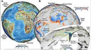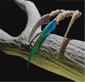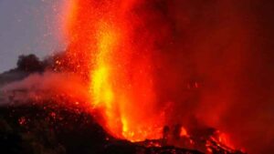
Earthquakes and volcanism occur as a result of plate tectonics. The movement of tectonic plates themselves is largely driven by the process known as subduction. The question of how new active subduction zones come into being, however, is still under debate. An example of this is the volcanic Lesser Antilles arc in the Caribbean. A research team including geophysicists Dr. Nicolas Riel and Professor Boris Kaus of Johannes Gutenberg University Mainz (JGU) as well as researchers from Universidade de Lisboa (ULisboa) recently developed models that simulated the occurrences in the Caribbean region during the Cretaceous, when a subduction event in the Eastern Pacific led to the formation of a new subduction zone in the Atlantic. The computer simulations show how the collision of the old Caribbean plateau with the Greater Antilles arc contributed to the creation of this new Atlantic subduction zone. Some 86 million years ago, the triggered processes subsequently resulted in a major mantle flow and thus to the development of the Caribbean large igneous province.
Subduction as a driving force of plate tectonics
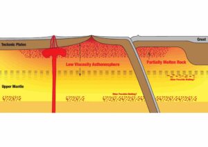
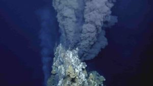
Subduction is a geological process in which the cold oceanic lithosphere, which is part of the rocky and about 100 kilometer thick outermost layer of the planet, runs into the edge of a continental plate and slides beneath it to be recycled back into the Earth’s mantle. Together with the release of hot mantle material in the form of mantle plumes and new oceanic floor generation at mid-ocean ridges, subduction events form the backbone of plate tectonics. However, it is largely unknown how active subduction zones form mainly because there are very few examples of ongoing subduction initiation currently here on Earth. With this in view, Dr. Nicolas Riel and Professor Boris Kaus of the JGU Institute of Geosciences decided to investigate the geodynamic conditions that would have predominated in the Caribbean region in the late Cretaceous period. “In terms of its plate tectonics, the Caribbean is a particularly interesting location,” said Professor Boris Kaus, head of the Geodynamics & Geophysics group at Mainz University. The Caribbean region can be seen as a kind of natural laboratory in which, over millions of years, plate tectonics resulted in the transfer of a subduction zone from the Pacific to the Atlantic. This was associated with very extensive magmatic activity that accounted for the origin of the Caribbean large igneous province (or CLIP for short). This structure of magmatic rock is now the center of the Caribbean plate.
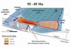
For their computer simulations, the researchers selected a point in time 140 million years ago when the so-called Farallon plate, an ancient major plate in the Eastern Pacific, began to move east and subduct beneath the South American margin, thus shifting the old Caribbean plateau in the direction of the Farallon trench. About 135 million years ago, the old Caribbean plateau came into collision with the proto-Caribbean plate. As the simulations showed, the subduction of the Farallon plate was then temporarily interrupted while the subduction of the proto-Caribbean plate was initiated. Several subsequent phases follow over a period of some 50 million years, including the renewed subduction of the Farallon plate at the western end of the old plateau, the formation of a mantle plume, and the transfer of the Greater Antilles arc onto the retreating proto-Caribbean plate.
Simultaneous subduction of two plates forced part of the mantle upwards
“With the help of our computer simulations, we can better understand the physical process,” added Dr. Nicolas Riel, the lead author of the corresponding article recently published in Nature Communications. “We were all surprised by the results showing that 90 to 86 million years ago the renewal of the Farallon plate subduction led to a major mantle flow, triggering the formation of a plume. This produced a huge amount of magma.” This molten rock material added to the thickness of the crust of the Caribbean plate, making it up to 22 kilometers in depth, thus 8 to 10 kilometers thicker than the standard for the oceanic crust. It was previously assumed that the mantle plume induced the renewal of the Farallon plate subduction.
“We are in the unique situation of being able to carry out very realistic simulations,” said Boris Kaus. His team is one of the few groups worldwide that can use supercomputer modeling to test to the plausibility of their physical assumptions and thus to analyze what plate tectonic events actually occurred in the Caribbean. For their complex calculations, the researchers had access to the MOGON II supercomputer operated by Johannes Gutenberg University Mainz and the Helmholtz Institute Mainz (HIM), one of the fastest high-performance computers in the world.
Research under the aegis of TeMaS
The geophysical research was undertaken under the aegis of the Terrestrial Magmatic Systems (TeMaS) research platform, a joint project of the universities of Mainz, Frankfurt, and Heidelberg. TeMaS coordinates interdisciplinary research on magmatic processes in the broadest sense, from the generation of magma in the Earth’s mantle through to its eruption in volcanoes and how this impacts the atmosphere and climate. TeMaS is a High-potential Research Area at JGU, funded by the Ministry of Science and Health of Rhineland-Palatinate.
Boris Kaus is Head of the Geodynamics & Geophysics group at the JGU Institute of Geosciences. In 2018, he was granted an ERC Consolidator Grant, one of the most richly endowed EU funding awards, to support his research into magmatic processes. As part of the ERC project MAGMA, short for “Melting And Geodynamic Models of Ascent,” Kaus and his team developed numerical models that enabled them to simulate magmatic events. The geophysicist is also a Fellow of the Gutenberg Research College (GRC) of JGU.
Reference:
Nicolas Riel, João C. Duarte, Jaime Almeida, Boris J. P. Kaus, Filipe Rosas, Yamirka Rojas-Agramonte, Anton Popov. Subduction initiation triggered the Caribbean large igneous province. Nature Communications, 2023; 14 (1) DOI: 10.1038/s41467-023-36419-x
Note: The above post is reprinted from materials provided by Johannes Gutenberg Universitaet Mainz.