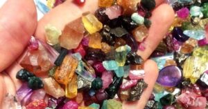
back to top
27.8 C
New York
Monday, May 6, 2024
Home Blog Page 18

500-million-year-old fossil represents rare discovery of ancient animal in North America

Researchers at the University of Missouri have found a rare, 500-million-year-old “worm-like” fossil called a palaeoscolecid, which is an uncommon fossil group in North America.

Many scientists consider the “Cambrian explosion” — which occurred about 530-540 million years ago — as the first major appearance of many of the world’s animal groups in the fossil record. Like adding pieces to a giant jigsaw puzzle, each discovery dating from this time period has added another piece to the evolutionary map of modern animals. Now, researchers at the University of Missouri have found a rare, 500-million-year-old “worm-like” fossil called a palaeoscolecid, which is an uncommon fossil group in North America. The researchers believe this find, from an area in western Utah, can help scientists better understand how diverse the Earth’s animals were during the Cambrian explosion.

Jim Schiffbauer, an associate professor of geological sciences in the MU College of Arts and Science and one of the study’s co-authors, said that while this fossil has the same anatomical organization as modern worms, it doesn’t exactly match with anything we see on modern Earth.

“This group of animals are extinct, so we don’t see them, or any modern relatives, on the planet today,” Schiffbauer said. “We tend to call them ‘worm-like’ because it’s hard to say that they perfectly fit with annelids, priapulids, or any other types of organism on the planet today that we would generally call a “worm.” But palaeoscolecids have the same general body plan, which in the history of life has been an incredibly successful body plan. So, this is a pretty cool addition because it expands the number of worm-like things that we know about from 500 million years ago in North America and adds to our global occurrences and diversity of the palaeoscolecids.”

At the time, this palaeoscolecid was likely living on an ocean floor, said Wade Leibach, an MU graduate teaching assistant in the College of Arts and Science, and lead author on the study.

“It is the first known palaeoscolecid discovery in a certain rock formation — the Marjum Formation of western Utah — and that’s important because this represents one of only a few palaeoscolecid taxa in North America,” Leibach said. “Other examples of this type of fossil have been previously found in much higher abundance on other continents, such as Asia, so we believe this find can help us better understand how we view prehistoric environments and ecologies, such as why different types of organisms are underrepresented or overrepresented in the fossil record. So, this discovery can be viewed from not only the perspective of its significance in North American paleontology, but also broader trends in evolution, paleogeography and paleoecology.”

Leibach, who switched his major from biology to geology after volunteering to work with the invertebrate paleontology collections at the University of Kansas, began this project as an undergraduate student by analyzing a box of about a dozen fossils in the collections of the KU Biodiversity Institute. Initially, Leibach and one of his co-authors, Anna Whitaker, who was a graduate student at KU at the time and now is at the University of Toronto-Mississauga, analyzed each fossil using a light microscope, which identified at least one of the fossils to be a palaeoscolecid.

Leibach worked with Julien Kimmig, who was at the KU Biodiversity Institute at the time and is now at Penn State University, to determine that, in order to be able to confirm their initial findings, he would need the help of additional analyses provided by sophisticated microscopy equipment located at the MU X-ray Microanalysis Core, which is directed by Schiffbauer. Using the core facility at MU, Leibach focused his analysis on the indentations left in the fossil by the ancient animal’s microscopic plates, which are characteristic of the palaeoscolecids.

“These very small mineralized plates are usually nanometers-to-micrometers in size, so we needed the assistance of the equipment in Dr. Schiffbauer’s lab to be able to study them in detail because their size, orientation and distribution is how we classify the organism to the genus and species levels,” Leibach said.

Leibach said the team found a couple reasons about why this particular fossil may be found in limited quantities in North America as compared to other parts of the world. They are:

  • Geochemical limitations or different environments that may be more predisposed to preserving these types of organisms.
  • Ecological competition, which may have driven this type of organism to be less competitive or less abundant in certain areas.

The new taxon is named Arrakiscolex aasei after the fictional planet Arrakis in the novel “Dune” by Frank Herbert, which is inhabited by a species of armored worm and the collector of the specimens Arvid Aase.

The study, “First palaeoscolecid from the Cambrian (Miaolingian, Drumian) Marjum Formation of western Utah,” was published in Acta Palaeontologica Polonica, an international quarterly journal which publishes papers from all areas of paleontology. Funding was provided by a National Science Foundation CAREER grant (1652351), a National Science Foundation Earth Sciences Instrumentation and Facilities grant (1636643), a University of Kansas Undergraduate Research grant, a student research grant provided by the South-Central Section of the Geological Society of America, and the J. Ortega-Hernández Laboratory for Invertebrate Palaeobiology at Harvard University. The study’s authors would like to thank Arvid Aase and Thomas T. Johnson for donating the specimens analyzed in the study.The new taxon is named Arrakiscolex aasei after the fictional planet Arrakis in the novel “Dune” by Frank Herbert, which is inhabited by a species of armored worm and the collector of the specimens Arvid Aase.

Reference:
Wade Leibach, Rudy Lerosey-Aubril, Anna Whitaker, James Schiffbauer, Julien Kimmig. First palaeoscolecid from the Cambrian (Miaolingian, Drumian) Marjum Formation of western Utah. Acta Palaeontologica Polonica, 2021; 66 DOI: 10.4202/app.00875.2021

Note: The above post is reprinted from materials provided by University of Missouri-Columbia.

Who was king before Tyrannosaurus? Uzbek fossil reveals new top dino

University of Tsukuba researchers have described a new apex predator from the lower Upper Cretaceous of Central Asia, Ulughbegsaurus uzbekistanensis, which coexisted with a smaller tyrannosauroid

Iconic tyrannosauroids like T. rex famously dominated the top of the food web at the end of the reign of the dinosaurs. But they didn’t always hold that top spot.

In a new study published in Royal Society Open Science, a research team led by the University of Tsukuba has described a new genus and species belonging to the Carcharodontosauria, a group of medium- to large-sized carnivorous dinosaurs that preceded the tyrannosauroids as apex predators.

The new dinosaur, named Ulughbegsaurus uzbekistanensis, was found in the lower Upper Cretaceous Bissekty Formation of the Kyzylkum Desert in Uzbekistan, and therefore lived about 90 million years ago. Two separate evolutionary analyses support classification of the new dinosaur as the first definitive carcharodontosaurian discovered in the Upper Cretaceous of Central Asia.

“We described this new genus and species based on a single isolated fossil, a left maxilla, or upper jawbone,” explains study first author Assistant Professor Kohei Tanaka. “Among theropod dinosaurs, the size of the maxilla can be used to estimate the animal’s size because it correlates with femur length, a well-established indicator of body size. Thus, we were able to estimate that Ulughbegsaurus uzbekistanensis had a mass of over 1,000 kg, and was approximately 7.5 to 8.0 meters in length, greater than the length of a full-grown African elephant.”

This size greatly exceeds that of any other carnivore known from the Bissekty Formation, including the small-sized tyrannosauroid Timurlengia described from the same formation. Therefore, the newly named dinosaur likely topped the food web in its early Late Cretaceous ecosystem.

The genus’s namesake is fittingly regal; Ulughbegsaurus is named for Ulugh Beg, the 15th century mathematician, astronomer, and sultan of the Timurid Empire of Central Asia. The species is named for the country where the fossil was discovered.

Before the Late Cretaceous, carcharodontosaurians like Ulughbegsaurus disappeared from the paleocontinent that included Central Asia. This disappearance is thought to have been related to the rise of tyrannosauroids as apex predators, but this transition has remained poorly understood because of the scarcity of relevant fossils.

Senior author Professor Yoshitsugu Kobayashi at the Hokkaido University Museum explains “The discovery of Ulughbegsaurus uzbekistanensis fills an important gap in the fossil record, revealing that carcharodontosaurians were widespread across the continent from Europe to East Asia. As one of the latest surviving carcharodontosaurians in Laurasia, this large predator’s coexistence with a smaller tyrannosauroid reveals important constraints on the transition of the apex predator niche in the Late Cretaceous.”

Reference:
Kohei Tanaka, Otabek Ulugbek Ogli Anvarov, Darla K. Zelenitsky, Akhmadjon Shayakubovich Ahmedshaev, Yoshitsugu Kobayashi. A new carcharodontosaurian theropod dinosaur occupies apex predator niche in the early Late Cretaceous of Uzbekistan. Royal Society Open Science, 2021; 8 (9): 210923 DOI: 10.1098/rsos.210923

Note: The above post is reprinted from materials provided by University of Tsukuba.

Massive new animal species discovered in half-billion-year-old Burgess Shale

Titanokorys gainesi reconstruction. Illustration by Lars Fields, © Royal Ontario Museum.

Palaeontologists at the Royal Ontario Museum (ROM) have uncovered the remains of a huge new fossil species belonging to an extinct animal group in half-a-billion-year-old Cambrian rocks from Kootenay National Park in the Canadian Rockies. The findings were announced on September 8, 2021, in a study published in Royal Society Open Science.

Named Titanokorys gainesi, this new species is remarkable for its size. With an estimated total length of half a meter, Titanokorys was a giant compared to most animals that lived in the seas at that time, most of which barely reached the size of a pinky finger.

“The sheer size of this animal is absolutely mind-boggling, this is one of the biggest animals from the Cambrian period ever found,” says Jean-Bernard Caron, ROM’s Richard M. Ivey Curator of Invertebrate Palaeontology.

Evolutionarily speaking, Titanokorys belongs to a group of primitive arthropods called radiodonts. The most iconic representative of this group is the streamlined predator Anomalocaris, which may itself have approached a metre in length. Like all radiodonts, Titanokorys had multifaceted eyes, a pineapple slice-shaped, tooth-lined mouth, a pair of spiny claws below its head to capture prey and a body with a series of flaps for swimming. Within this group, some species also possessed large, conspicuous head carapaces, with Titanokorys being one of the largest ever known.

“Titanokorys is part of a subgroup of radiodonts, called hurdiids, characterized by an incredibly long head covered by a three-part carapace that took on myriad shapes. The head is so long relative to the body that these animals are really little more than swimming heads,” added Joe Moysiuk, co-author of the study, and a ROM-based Ph.D. student in Ecology & Evolutionary Biology at the University of Toronto.

Why some radiodonts evolved such a bewildering array of head carapace shapes and sizes is still poorly understood and was likely driven by a variety of factors, but the broad flattened carapace form in Titanokorys suggests this species was adapted to life near the seafloor.

“These enigmatic animals certainly had a big impact on Cambrian seafloor ecosystems. Their limbs at the front looked like multiple stacked rakes and would have been very efficient at bringing anything they captured in their tiny spines towards the mouth. The huge dorsal carapace might have functioned like a plough,” added Dr. Caron, who is also an Associate Professor in Ecology & Evolutionary Biology and Earth Sciences at the University of Toronto, and Moysiuk’s Ph.D. advisor.

All fossils in this study were collected around Marble Canyon in northern Kootenay National Park by successive ROM expeditions. Discovered less than a decade ago, this area has yielded a great variety of Burgess Shale animals dating back to the Cambrian period, including a smaller, more abundant relative of Titanokorys named Cambroraster falcatusin reference to its Millennium Falcon-shaped head carapace. According to the authors, the two species might have competed for similar bottom-dwelling prey.

The Burgess Shale fossil sites are located within Yoho and Kootenay National Parks and are managed by Parks Canada. Parks Canada is proud to work with leading scientific researchers to expand knowledge and understanding of this key period of earth history and to share these sites with the world through award-winning guided hikes. The Burgess Shale was designated a UNESCO World Heritage Site in 1980 due to its outstanding universal value and is now part of the larger Canadian Rocky Mountain Parks World Heritage Site.

The discovery of Titanokorys gainesi was profiled in the CBC’s The Nature of Things episode “First Animals.” These and other Burgess Shale specimens will be showcased in a new gallery at ROM, the Willner Madge Gallery, Dawn of Life, opening in December 2021.

Major funding support for the research and fieldwork came from the Polk Milstein Family, ROM, the National Geographic Society (#9475-14 to JBC), the Swedish Research Council (to Michael Streng), the National Science Foundation (NSF-EAR-1556226, 1554897) and Pomona College (to Robert R. Gaines). This research is also supported by a National Science and Engineering Research Council (NSERC) Discovery grant to J.-B.C and a Vanier Canada Graduate Scholarship through the University of Toronto (Dept. of Ecology and Evolution) to J.M.

Reference:
J.-B. Caron, J. Moysiuk. A giant nektobenthic radiodont from the Burgess Shale and the significance of hurdiid carapace diversity. Royal Society Open Science, 2021; 8 (9): 210664 DOI: 10.1098/rsos.210664

Note: The above post is reprinted from materials provided by Royal Ontario Museum.

Researchers identify new source for earthquakes and tsunamis in the Greater Tokyo Region

Jessica Pilarczyk (SFU) and collaborator Tina Dura (Virginia Tech) sample sediment cores from rice paddies of the Greater Tokyo Region that contain evidence for an earthquake from 1,000 years ago that potentially originated from a historically unconsidered earthquake source. Credit: SFU

Researchers have discovered geologic evidence that unusually large earthquakes and tsunamis from the Tokyo region — located near tectonic plate boundaries that are recognized as a seismic hazard source — may be traceable to a previously unconsidered plate boundary. The team, headed by Simon Fraser University Earth scientist Jessica Pilarczyk, has published its research today in Nature Geoscience.

The team’s ground-breaking discovery represents a new and unconsidered seismic risk for Japan with implications for countries lining the Pacific Rim, including Canada.

Pilarczyk points to low-lying areas like Delta, Richmond and Port Alberni as potentially vulnerable to tsunamis originating from this region.

In 2011, eastern Japan was hit with a massive magnitude 9 quake — creating the largest rupture area of any earthquake originating from the Japan Trench. It triggered the Fukushima Daiichi nuclear disaster and a tsunami that travelled thousands of miles away — impacting the shores of British Columbia, California, Oregon, Hawaii and Chile.

For the past decade, Pilarczyk and an international team of collaborators have been working with the Geological Survey of Japan to study Japan’s unique geologic history. Together, they uncovered and analyzed sandy deposits from the Boso Peninsula region (50 km east of Tokyo) that they attribute to an unusually large tsunami that occurred about 1,000 years ago.

Until now, scientists did not have historical records to ascertain if a portion of the Philippine Sea/Pacific plate boundary near the Boso Peninsula was capable of generating large tsunamis similar in size as the Tohoku event in 2011.

Using a combination of radiocarbon dating, geologic and historical records, and paleoecology, the team used 13 hypothetical and historical models to assess each of the three plate boundaries, including the Continental/Philippine Sea plate boundary (Sagami Trough), the Continental/Pacific plate boundary (Japan Trench) and the Philippine Sea/Pacific plate boundary (Izu-Bonin Trench) as sources of the 1,000-year-old earthquake.

Pilarczyk reports that the modeled scenarios suggest that the source of the tsunami from 1,000 years ago originated from the offshore area off the Boso Peninsula — the smallest of which (for example, possible earthquakes with the lowest minimum magnitude), are linked to the previously unconsidered Izu-Bonin Trench at the boundary of the Philippine Sea and Pacific plates.

“Earthquake hazard assessments for the Tokyo region are complicated by the ‘trench-trench triple junction’, where the oceanic Philippine Sea Plate not only underthrusts a continental plate but is also being subducted by the Pacific Plate,” says Pilarczyk, an assistant professor of Earth sciences at SFU who holds a Canada Research Chair in Natural Hazards. “Great thrust earthquakes and associated tsunamis are historically recognized hazards from the Continental/Philippine Sea (Sagami Trough) and Continental/Pacific (Japan Trench) plate boundaries but not from the Philippine Sea/Pacific boundary alone.”

Pilarczyk hopes that these findings will be used to produce better informed seismic hazard maps for Japan. She also says that this information could be used by far-field locations, including Canada, to inform building practices and emergency management strategies that would help mitigate the destructive consequences of an earthquake similar to the one of 1,000 years ago.

Reference:
Jessica E. Pilarczyk, Yuki Sawai, Yuichi Namegaya, Toru Tamura, Koichiro Tanigawa, Dan Matsumoto, Tetsuya Shinozaki, Osamu Fujiwara, Masanobu Shishikura, Yumi Shimada, Tina Dura, Benjamin P. Horton, Andrew C. Parnell, Christopher H. Vane. A further source of Tokyo earthquakes and Pacific Ocean tsunamis. Nature Geoscience, Sept. 2, 2021; DOI: 10.1038/s41561-021-00812-2

Note: The above post is reprinted from materials provided by Simon Fraser University. Original written by Diane Mar-Nicolle.

Volcanic eruptions may have spurred first ‘whiffs’ of oxygen in Earth’s atmosphere

Volcanic eruption
Volcanic eruption

A new analysis of 2.5-billion-year-old rocks from Australia finds that volcanic eruptions may have stimulated population surges of marine microorganisms, creating the first puffs of oxygen into the atmosphere. This would change existing stories of Earth’s early atmosphere, which assumed that most changes in the early atmosphere were controlled by geologic or chemical processes.

Though focused on Earth’s early history, the research also has implications for extraterrestrial life and even climate change. The study led by the University of Washington, the University of Michigan and other institutions was published in August in the Proceedings of the National Academy of Sciences.

“What has started to become obvious in the past few decades is there actually are quite a number of connections between the solid, nonliving Earth and the evolution of life,” said first author Jana Meixnerová, a UW doctoral student in Earth and space sciences. “But what are the specific connections that facilitated the evolution of life on Earth as we know it?”

In its earliest days, Earth had no oxygen in its atmosphere and few, if any, oxygen-breathing lifeforms. Earth’s atmosphere became permanently oxygen-rich about 2.4 billion years ago, likely after an explosion of lifeforms that photosynthesize, transforming carbon dioxide and water into oxygen.

But in 2007, co-author Ariel Anbar at Arizona State University analyzed rocks from the Mount McRae Shale in Western Australia, reporting a short-term whiff of oxygen about 50 to 100 million years before it became a permanent fixture in the atmosphere. More recent research has confirmed other, earlier, short-term oxygen spikes, but hasn’t explained their rise and fall.

In the new study, researchers at the University of Michigan, led by co-corresponding author Joel Blum, analyzed the same ancient rocks for the concentration and number of neutrons in the element mercury, emitted by volcanic eruptions. Large volcanic eruptions blast mercury gas into the upper atmosphere, where today it circulates for a year or two before raining out onto Earth’s surface. The new analysis shows a spike in mercury a few million years before the temporary rise in oxygen.

“Sure enough, in the rock below the transient spike in oxygen we found evidence of mercury, both in its abundance and isotopes, that would most reasonably be explained by volcanic eruptions into the atmosphere,” said co-author Roger Buick, a UW professor of Earth and Space Sciences.

Where there were volcanic emissions, the authors reason, there must have been lava and volcanic ash fields. And those nutrient-rich rocks would have weathered in the wind and rain, releasing phosphorus into rivers that could fertilize nearby coastal areas, allowing oxygen-producing cyanobacteria and other single-celled lifeforms to flourish.

“There are other nutrients that modulate biological activity on short timescales, but phosphorus is the one that is most important on long timescales,” Meixnerová said.

Today, phosphorus is plentiful in biological material and in agricultural fertilizer. But in very ancient times, weathering of volcanic rocks would have been the main source for this scarce resource.

“During weathering under the Archaean atmosphere, the fresh basaltic rock would have slowly dissolved, releasing the essential macro-nutrient phosphorus into the rivers. That would have fed microbes that were living in the shallow coastal zones and triggered increased biological productivity that would have created, as a byproduct, an oxygen spike,” Meixnerová said.

The precise location of those volcanoes and lava fields is unknown, but large lava fields of about the right age exist in modern-day India, Canada and elsewhere, Buick said.

“Our study suggests that for these transient whiffs of oxygen, the immediate trigger was an increase in oxygen production, rather than a decrease in oxygen consumption by rocks or other nonliving processes,” Buick said. “It’s important because the presence of oxygen in the atmosphere is fundamental — it’s the biggest driver for the evolution of large, complex life.”

Ultimately, researchers say the study suggests how a planet’s geology might affect any life evolving on its surface, an understanding that aids in identifying habitable exoplanets, or planets outside our solar system, in the search for life in the universe.

Other authors of the paper are co-corresponding author Eva Stüeken, a former UW astrobiology graduate student now at the University of St. Andrews in Scotland; Michael Kipp, a former UW graduate student now at the California Institute of Technology; and Marcus Johnson at the University of Michigan. The study was funded by NASA, the NASA-funded UW Virtual Planetary Laboratory team and the MacArthur Professorship to Blum at the University of Michigan.

Reference:
Jana Meixnerová, Joel D. Blum, Marcus W. Johnson, Eva E. Stüeken, Michael A. Kipp, Ariel D. Anbar, Roger Buick. Mercury abundance and isotopic composition indicate subaerial volcanism prior to the end-Archean “whiff” of oxygen. Proceedings of the National Academy of Sciences, 2021; 118 (33): e2107511118 DOI: 10.1073/pnas.2107511118

Note: The above post is reprinted from materials provided by University of Washington. Original written by Hannah Hickey.

Confiscated fossil turns out to be exceptional flying reptile from Brazil

Entombed in limestone blocks, the newly studied fossil is the first nearly complete skeleton of a pterosaur species that was first described in 2003. Photograph by Victor Beccari

A fossil acquired in a police raid has turned out to be one of the best-preserved flying reptiles ever found, according to a study published August 11, 2021 in the open-access journal PLOS ONE by Victor Beccari of the University of São Paulo and colleagues.

Tapejarids (an Early Cretaceous subgroup of flying reptiles called pterosaurs) are known for their enormous head crests and their abundance in the fossil record of Brazil, but most Brazilian tapejarid fossils preserve only partial remains. In this study, researchers describe an exceptional tapejarid specimen which includes nearly the entire body, mostly intact and even including remnants of soft tissue alongside the bones, making it the most complete tapejarid skeleton ever found in Brazil.

This fossil belongs to a species called Tupandactylus navigans, and it has a dramatic history. It is preserved across six square-cut limestone slabs which were confiscated during a police raid at Santos Harbour in São Paulo. It is now among the collections of the University of São Paulo, where researchers were able to reunite the slabs and examine the entire fossil, even CT-scanning to reveal the bones concealed within the stone. This is the first time that paleontologists have been able to study more than just the skull of this species.

The description suggests this species had a terrestrial foraging lifestyle, due to its long neck and the proportions of its limbs, as well as its large head crest that could negatively influence long-distance flight. However, the specimen possesses all the necessary adaptation for powered flight, such as the presence of a notarium and a developed muscle anchoring region in the arm bones. This specimen also has an unusually large crest on its chin, part of its already impressive skull ornamentation. Precisely how all these factors contributed to the flight performance and lifestyle of these animals will be a subject of future research, among the many other questions that can be answered through study of this exceptional fossil.

The authors add: “We described the most complete tapejarid fossil from Brazil, a partially articulated skeleton of Tupandactylus navigans with soft tissue preservation. This specimen brings new insights into the anatomy of this animal and its constraints for flight, arguing for terrestrial foraging ecology.”

Reference:
Victor Beccari, Felipe Lima Pinheiro, Ivan Nunes, Luiz Eduardo Anelli, Octávio Mateus, Fabiana Rodrigues Costa. Osteology of an exceptionally well-preserved tapejarid skeleton from Brazil: Revealing the anatomy of a curious pterodactyloid clade. PLOS ONE, 2021; 16 (8): e0254789 DOI: 10.1371/journal.pone.0254789

Note: The above post is reprinted from materials provided by PLOS.

Geologists dig into Grand Canyon’s mysterious gap in time

Grand Canyon, Arizona

A new study led by the University of Colorado Boulder reveals the complex history behind one of the Grand Canyon’s most well-known geologic features: A mysterious and missing gap of time in the canyon’s rock record that covers hundreds of millions of years.

The research comes closer to solving a puzzle, called the “Great Unconformity,” that has perplexed geologists since it was first described nearly 150 years ago.

Think of the red bluffs and cliffs of the Grand Canyon as Earth’s history textbook, explained Barra Peak, lead author of the new study and a graduate student in geological sciences at CU Boulder. If you scale down the canyon’s rock faces, you can jump back almost 2 billion years into the planet’s past. But that textbook is also missing pages: In some areas, more than 1 billion years’ worth of rocks have disappeared from the Grand Canyon without a trace.

Geologists want to know why.

“The Great Unconformity is one of the first well-documented geologic features in North America,” Peak said. “But until recently, we didn’t have a lot of constraints on when or how it occurred.”

Now, she and her colleagues think they may be narrowing in on an answer in a paper published this month in the journal Geology. The team reports that a series of small yet violent faulting events may have rocked the region during the breakup of an ancient supercontinent called Rodinia. The resulting havoc likely tore up the earth around the canyon, causing rocks and sediment to wash away and into the ocean.

The team’s findings could help scientists fill in missing pieces of what happened during this critical period for the Grand Canyon — today one of North America’s foremost natural wonders.

“We have new analytical methods in our lab that allow us to decipher the history in the missing window of time across the Great Unconformity,” said Rebecca Flowers, coauthor of the new study and a professor of geological sciences. “We are doing this in the Grand Canyon and at other Great Unconformity localities across North America.”

Beautiful lines

It’s a mystery that goes back a long way. John Wesley Powell, the namesake of today’s Lake Powell, first saw the Great Unconformity during his famed 1869 expedition by boat down the rapids of the Colorado River.

Peak, who completed a similar research rafting trip through the Grand Canyon in spring 2021, said that the feature is stark enough that you can see it from the river.

“There are beautiful lines,” Peak said. “At the bottom, you can see very clearly that there are rocks that have been pushed together. Their layers are vertical. Then there there’s a cutoff, and above that you have these beautiful horizontal layers that form the buttes and peaks that you associate with the Grand Canyon.”

The difference between those two types of rocks is significant. In the western part of the canyon toward Lake Mead, the basement stone is 1.4 to 1.8 billion years old. The rocks sitting on top, however, are just 520 million years old. Since Powell’s voyage, scientists have seen evidence of similar periods of lost time at sites around North America.

“There’s more than a billion years that’s gone,” Peak said. “It’s also a billion years during an interesting part of Earth’s history where the planet is transitioning from an older setting to the modern Earth we know today.”

A continent splits

To explore the transition, Peak and her colleagues employed a method called “thermochronology,” which tracks the history of heat in stone. Peak explained that, when geologic formations are buried deep underground, the pressure building on top of them can cause them to get toasty. That heat, in turn, leaves a trace in the chemistry of minerals in those formations.

Using this approach, the researchers conducted a survey of samples of rock collected from throughout the Grand Canyon. They discovered that the history of this feature may be more convoluted than scientists have assumed. In particular, the western half of the canyon and its eastern portion (the part that tourists are most familiar with) may have undergone different geologic contortions throughout time.

“It’s not a single block with the same temperature history,” Peak said.

Roughly 700 million years ago, basement rock in the west seems to have risen to the surface. In the eastern half, however, that same stone was under kilometers of sediment.

The difference likely came down to the breakup of Rodinia, a gigantic land mass that began to pull apart at about the same time, Peak said. The researchers results suggest that this major upheaval may have torn at the eastern and western halves of the Grand Canyon in different ways and at slightly different times — producing the Great Unconformity in the process.

Peak and her colleagues are now looking at other sites of the Great Unconformity in North America to see how general this picture might be. For now, she’s excited to watch geologic history play out in one of the country’s most picturesque landscapes.

“There are just so many things there that aren’t present anywhere else,” she said. “It’s a really amazing natural lab.”

Other coauthors of the new study included John Cottle and Francis Macdonald of the University of California, Santa Barbara.

Reference:
B.A. Peak, R.M. Flowers, F.A. Macdonald, J.M. Cottle. Zircon (U-Th)/He thermochronology reveals pre-Great Unconformity paleotopography in the Grand Canyon region, USA. Geology, 2021; DOI: 10.1130/G49116.1

Note: The above post is reprinted from materials provided by University of Colorado at Boulder. Original written by Daniel Strain.

Volcanism drove rapid ocean deoxygenation during the time of the dinosaurs

Core samples for Oceanic Anoxic Event 1a. Credit: Elisabetta Erba.

Ocean deoxygenation during the Mesozoic Era was much more rapid than previous thought, with CO2 induced environmental warming creating ocean ‘dead zones’ over timescales of only tens of thousands of years.

The research from University of British Columbia (UBC) and University of Hong Kong (HKU) Earth scientists paints a new picture of severe ocean deoxygenation events in our planet’s geologic history.

“Physical drivers, in particular ocean warming linked to volcanic activity during the Cretaceous Period, played key roles in triggering and maintaining oceanic anoxia,” says lead researcher Dr. Kohen Bauer, who began the work while at UBC and completed the study with HKU’s Department of Earth Sciences.

“The same mechanisms are also critically important drivers of modern ocean deoxygenation and expanding marine dead zones. Today, in addition to volcanoes releasing CO2 into the atmosphere, humans are as well.”

Previous research tended to focus on the role ocean nutrient cycles played in causing so called ‘dead zones’ — a process that would have driven ocean deoxygenation over much longer timescales of hundreds of thousands of years. However, it’s now clear that massive volcanism and its associated feedbacks was a more direct trigger for the rapid development of oceanic anoxia.

The research delved into the causes of Oceanic Anoxic Event 1a — an interval 120 million years ago when large swaths of Earth’s oceans became anoxic. Those conditions likely persisted for almost a million years, causing climate perturbations, and biotic turnover.

The scientists reconstructed the period’s environmental conditions using novel geochemical methods and ancient sediments deposited in both the paleo-Tethys and paleo-Pacific oceans.

“Mesozoic oceanic anoxic events are some of the most important analogs for unlocking lessons about warm-Earth climate states in the geological record,” says UBC’s Dr. Sean Crowe, author on the paper and Canada Research Chair in Geomicrobiology with UBC’s departments of Microbiology and Immunology, and Earth, Ocean and Atmospheric Sciences.

“These events provide enormous potential to help us better understand the sensitivity of the Earth system to perturbations in global biogeochemical cycles, marine biology, and climate on timescales relevant to humankind.”

Reference:
Kohen W. Bauer, Cinzia Bottini, Robert Frei, Dan Asael, Noah J. Planavsky, Roger Francois, N. Ryan McKenzie, Elisabetta Erba, Sean A. Crowe. Pulsed volcanism and rapid oceanic deoxygenation during Oceanic Anoxic Event 1a. Geology, 2021; DOI: 10.1130/G49065.1

Note: The above post is reprinted from materials provided by University of British Columbia.

Volcanoes acted as a safety valve for Earth’s long-term climate

Continental volcanic arcs such as this one in Kamchatka, Russia, are rapidly weathered, driving CO2 removal from the atmosphere over geological time. Credit: Tom Gernon, University of Southampton

Scientists at the University of Southampton have discovered that extensive chains of volcanoes have been responsible for both emitting and then removing atmospheric carbon dioxide (CO2) over geological time. This stabilised temperatures at Earth’s surface.

The researchers, working with colleagues at the University of Sydney, Australian National University (ANU), University of Ottawa and University of Leeds, explored the combined impact of processes in the solid Earth, oceans and atmosphere over the past 400 million years. Their findings are published in the journal Nature Geoscience.

Natural break-down and dissolution of rocks at Earth’s surface is called chemical weathering. It is critically important because the products of weathering (elements like calcium and magnesium) are flushed via rivers to the oceans, where they form minerals that lock up CO2. This feedback mechanism regulates atmospheric CO2 levels, and in turn global climate, over geological time.

“In this respect, weathering of the Earth’s surface serves as a geological thermostat,” says lead author Dr Tom Gernon, Associate Professor in Earth Science at the University of Southampton, and a Fellow of the Turing Institute. “But the underlying controls have proven difficult to determine due to the complexity of the Earth system.”

“Many Earth processes are interlinked, and there are some major time lags between processes and their effects,” explains Eelco Rohling, Professor in Ocean and Climate Change at ANU and co-author of the study. “Understanding the relative influence of specific processes within the Earth system response has therefore been an intractable problem.”

To unravel the complexity, the team constructed a novel “Earth network,” incorporating machine-learning algorithms and plate tectonic reconstructions. This enabled them to identify the dominant interactions within the Earth system, and how they evolved through time.

The team found that continental volcanic arcs were the most important driver of weathering intensity over the past 400 million years. Today, continental arcs comprise chains of volcanoes in, for example, the Andes in South America, and the Cascades in the US. These volcanoes are some of the highest and fastest eroding features on Earth. Because the volcanic rocks are fragmented and chemically reactive, they are rapidly weathered and flushed into the oceans.

Martin Palmer, Professor of Geochemistry at the University of Southampton and co-author of the study, said: “It’s a balancing act. On one hand, these volcanoes pumped out large amounts of CO2 that increased atmospheric CO2 levels. On the other hand, these same volcanoes helped remove that carbon via rapid weathering reactions.”

The study casts doubt on a long-held concept that Earth’s climate stability over tens to hundreds of millions of years reflects a balance between weathering of the seafloor and continental interiors. “The idea of such a geological tug of war between the landmasses and the seafloor as a dominant driver of Earth surface weathering is not supported by the data,” Dr Gernon states.

“Unfortunately, the results do not mean that nature will save us from climate change,” stresses Dr Gernon. “Today, atmospheric CO2 levels are higher than at any time in the past 3 million years, and human-driven emissions are about 150 times larger than volcanic CO2 emissions. The continental arcs that appear to have saved the planet in the deep past are simply not present at the scale needed to help counteract present-day CO2 emissions.”

But the team’s findings still provide critical insights into how society might manage the current climate crisis. Artificially enhanced rock weathering — where rocks are pulverised and spread across land to speed up chemical reaction rates — could play a key role in safely removing CO2 from the atmosphere. The team’s findings suggest that such schemes may be deployed optimally by using calc-alkaline volcanic materials (those containing calcium, potassium and sodium), like those found in continental arc environments.

“This is by no means a silver bullet solution to the climate crisis — we urgently need to reduce CO2 emissions in line with IPCC mitigation pathways, full stop. Our assessment of weathering feedbacks over long timescales may help in designing and evaluating large-scale enhanced weathering schemes, which is just one of the steps needed to counteract global climate change,” Dr Gernon concludes.

Reference:
Thomas M. Gernon, Thea K. Hincks, Andrew S. Merdith, Eelco J. Rohling, Martin R. Palmer, Gavin L. Foster, Clément P. Bataille, R. Dietmar Müller. Global chemical weathering dominated by continental arcs since the mid-Palaeozoic. Nature Geoscience, 2021; DOI: 10.1038/s41561-021-00806-0

Note: The above post is reprinted from materials provided by University of Southampton.

Geologists take Earth’s inner temperature using erupted sea glass

A map of the World Ocean Floor. Credit: Library of Congress, Geography and Map Division

If the Earth’s oceans were drained completely, they would reveal a massive chain of undersea volcanoes snaking around the planet. This sprawling ocean ridge system is a product of overturning material in the Earth’s interior, where boiling temperatures can melt and loft rocks up through the crust, splitting the sea floor and reshaping the planet’s surface over hundreds of millions of years.

Now geologists at MIT have analyzed thousands of samples of erupted material along ocean ridges and traced back their chemical history to estimate the temperature of the Earth’s interior.

Their analysis shows that the temperature of the Earth’s underlying ocean ridges is relatively consistent, at around 1,350 degrees Celsius—about as hot as a gas range’s blue flame. There are, however, “hotspots” along the ridge that can reach 1,600 degrees Celsius, comparable to the hottest lava.

The team’s results, appearing today in the Journal of Geophysical Research: Solid Earth, provide a temperature map of the Earth’s interior around ocean ridges. With this map, scientists can better understand the melting processes that give rise to undersea volcanoes, and how these processes may drive the pace of plate tectonics over time.

“Convection and plate tectonics have been important processes in shaping Earth history,” says lead author Stephanie Brown Krein, a postdoc in MIT’s Department of Earth, Atmospheric and Planetary Sciences (EAPS). “Knowing the temperature along this whole chain is fundamental to understanding the planet as a heat engine, and how Earth might be different from other planets and able to sustain life.”

Krein’s co-authors include Zachary Molitor, an EAPS graduate student, and Timothy Grove, the R.R. Schrock Professor of Geology at MIT.

A chemical history

The Earth’s interior temperature has played a critical role in shaping the planet’s surface over hundreds of millions of years. But there’s been no way to directly read this temperature tens to hundreds of kilometers below the surface. Scientists have applied indirect means to infer the temperature of the upper mantle—the layer of the Earth just below the crust. But estimates thus far are inconclusive, and scientists disagree about how widely temperatures vary beneath the surface.

For their new study, Krein and her colleagues developed a new algorithm, called ReversePetrogen, that is designed to trace a rock’s chemical history back in time, to identify its original composition of elements and determine the temperature at which the rock initially melted below the surface.

The algorithm is based on years of experiments carried out in Grove’s lab to reproduce and characterize the melting processes of the Earth’s interior. Researchers in the lab have heated up rocks of various compositions, reaching various temperatures and pressures, to observe their chemical evolution. From these experiments, the team has been able to derive equations—and ultimately, the new algorithm—to predict the relationships between a rock’s temperature, pressure, and chemical composition.

Krein and her colleagues applied their new algorithm to rocks collected along the Earth’s ocean ridges—a system of undersea volcanoes spanning more than 70,000 kilometers in length. Ocean ridges are regions where tectonic plates are spread apart by the eruption of material from the Earth’s mantle—a process that is driven by underlying temperatures.

“You could effectively make a model of the temperature of the entire interior of the Earth, based partly on the temperature at these ridges,” Krein says. “The question is, what is the data really telling us about the temperature variation in the mantle along the whole chain?”

Mantle map

The data the team analyzed include more than 13,500 samples collected along the length of the ocean ridge system over several decades, by multiple research cruises. Each sample in the dataset is of an erupted sea glass—lava that erupted in the ocean and was instantly chilled by the surrounding water into a pristine, preserved form.

Scientists previously identified the chemical compositions of each glass in the dataset. Krein and her colleagues ran each sample’s chemical compositions through their algorithm to determine the temperature at which each glass originally melted in the mantle.

In this way, the team was able to generate a map of mantle temperatures along the entire length of the ocean ridge system. From this map, they observed that much of the mantle is relatively homogenous, with an average temperature of around 1,350 degrees Celsius. There are however, “hotspots,” or regions along the ridge, where temperatures in the mantle appear significantly hotter, at around 1,600 degrees Celsius.

“People think of hotspots as regions in the mantle where it’s hotter, and where material may be melting more, and potentially rising faster, and we don’t exactly know why, or how much hotter they are, or what the role of composition is at hotspots,” Krein says. “Some of these hotspots are on the ridge, and now we may get a sense of what the hotspot variation is globally using this new technique. That tells us something fundamental about the temperature of the Earth now, and now we can think of how it’s changed over time.”

Krein adds: “Understanding these dynamics will help us better determine how continents grew and evolved on Earth, and when subduction and plate tectonics started—which are critical for complex life.”

Note: The above post is reprinted from materials provided by Massachusetts Institute of Technology.

Giant friction experiment at Kilauea volcano

A wide-angle aerial view looks southeast over Kīlauea’s summit caldera on July 22, 2021. Large cliffs formed during the 2018 collapses are visible on the left side of the photo. A recently active lava lake is visible in the lower right. (Image credit: M. Patrick, USGS)

On April 30, 2018, on the eastern flank of Hawaii’s Kīlauea volcano, lava suddenly drained from a crater that had been spewing lava for more than three decades. Then the floor of the crater, named Pu’u’ō’ō, dropped out.

Within 48 hours, the lava lake at Kīlauea’s summit 12 miles northwest of Pu’u’ō’ō began to fall as magma drained into the volcano’s plumbing. Soon, new cracks opened 12 miles east of Pu’u’ō’ō and molten lava spurted out, crept over roads, burned trees and torched power poles.

Over three months, Kīlauea spat out enough lava to fill 320,000 Olympic-sized swimming pools, destroyed more than 700 homes and displaced thousands of people. The summit landscape itself was transformed as its crater collapsed by as much as 1,500 feet throughout the summer in a way that scientists are only beginning to understand.

“In the entire 60 years of modern geophysical instrumentation of volcanoes, we’ve had only half a dozen caldera collapses,” said Stanford University geophysicist Paul Segall, lead author of a new study in Proceedings of the National Academy of Sciences that helps explain how these events unfold and finds evidence confirming the reigning scientific paradigm for how friction works on earthquake faults.

The results may help to inform future hazard assessments and mitigation efforts around volcanic eruptions. “Improving our understanding of the physics governing caldera collapses will help us to better understand the conditions under which collapses are possible and forecast the evolution of a collapse sequence once it begins,” said co-author Kyle Anderson, PhD ’12, a geophysicist with the U.S. Geological Survey who was part of the team working on-site at Kīlauea during the 2018 eruption.

The nature of friction

A key factor controlling the collapse of volcanic calderas — and the rupture of earthquake faults around the world — is friction. It’s ubiquitous in nature and our everyday lives, coming into play any time two surfaces move relative to each other. But interactions between surfaces are so complex that, despite centuries of study, scientists still don’t completely understand how friction behaves in different situations. “It’s not something that we can entirely predict using only equations. We also need data from experiments,” Segall said.

Scientists seeking to understand the role of friction in earthquakes usually run these experiments in labs using rock slabs barely larger than a door and often closer to the size of a deck of cards. “One of the big challenges in earthquake science has been to take these friction laws and the values that were found in the laboratory, and apply them to, say, the San Andreas Fault, because it’s such an enormous jump in scale,” said Segall, the Cecil H. and Ida M. Green Professor of Geophysics at Stanford’s School of Earth, Energy & Environmental Sciences (Stanford Earth).

In the new study, published July 23, Segall and Anderson examine the slipping and sticking of Kīlauea volcano’s collapse block — a chunk of crust five miles around and half a mile deep — to characterize friction at a much larger scale. “We set out to develop a mathematical model of that collapse, highly simplified, but using modern understanding of friction,” Segall said.

Kīlauea’s collapse

Kīlauea’s caldera collapsed not in one smooth descent, but rather like a sticky piston. Roughly every day and a half, the collapse block dropped by nearly eight feet in a matter of seconds, then stopped. That’s because as magma in the chamber below the caldera surged out to fissures in Kīlauea’s lower eastern flank, it took away support for the overlying rock. “Eventually, the pressure becomes low enough that the floor falls in and it starts collapsing, like a sinkhole,” Segall said.

By the time the 2018 Kīlauea eruption ended, the volcano’s piston-like collapse events repeated 62 times — with each one triggering an earthquake and every move tracked down to the millimeter every five seconds by an array of 20 global positioning system (GPS) instruments. During the first few dozen collapse events, the geometry of the rock surfaces changed, but they held stable for the final 30 halting descents.

The new research shows that for this type of eruption, when the eruptive vent is at a lower elevation, it leads to a bigger drop in pressure below the caldera block — which then makes it more likely that a collapse event will start. Once collapse initiates, the weight of the massive caldera block maintains pressure on the magma, forcing it to the eruption site. “If not for the collapse, the eruption would have undoubtedly ended much sooner,” Segall said.

Evolving friction

Segall and Anderson’s analysis of the trove of data from Kīlauea’s caldera collapse confirms that, even at the vast scale of this volcano, the ways different rock surfaces slip and slide past one another or stick at different speeds and pressures over time are very similar to what scientists have found in small-scale laboratory experiments.

Specifically, the new results provide an upper bound for an important factor in earthquake mechanics known as slip-weakening distance, which geophysicists use to calculate how faults become unstuck. This is the distance over which the frictional strength of a fault weakens before rupturing — something that’s central to accurate modeling of the stability and buildup of energy on earthquake faults. Laboratory experiments have suggested this distance could be as short as tens of microns — equivalent to the width of a hair spliced into a few dozen slivers — while estimates from real earthquakes indicate it could be as long as 20 centimeters.

The new modeling now shows this evolution occurs over no more than 10 millimeters, and possibly much less. “The uncertainties are bigger than they are in the lab, but the friction properties are completely consistent with what’s measured in the laboratory, and that’s very confirming,” Segall said. “It tells us that we’re okay taking those measurements from really small samples and applying them to big tectonic faults because they held true in the behavior we observed in Kīlauea’s collapse.”

The new work also adds realistic complexity to a mathematical piston model, proposed a decade ago by Japanese volcanologist Hiroyuki Kumagai and colleagues, to explain a large caldera collapse on Miyake Island, Japan. While the widely embraced Kumagai model assumed the volcano’s rock surfaces changed as if by flipping a switch from being stationary relative to each other to slipping past one another, the new modeling recognizes that the transition between “static” and “dynamic” friction is more complex and gradual. “Nothing in nature occurs instantaneously,” Segall said.

Reference:
Paul Segall, Kyle Anderson. Repeating caldera collapse events constrain fault friction at the kilometer scale. Proceedings of the National Academy of Sciences, 2021; 118 (30): e2101469118 DOI: 10.1073/pnas.2101469118

Note: The above post is reprinted from materials provided by Stanford University.

Sea levels influence eruptions on volcanic island

The cliffs of the volcanic island of Santorini showing the layers of deposits from past volcanic eruptions. Credit: co-author Dr. Ralf Gertisser (Keele University).

The rise and fall of sea levels influence the likelihood of volcanic eruptions on the Greek island of Santorini, new research led by Oxford Brookes University has discovered. Analysing the timings of eruptions over hundreds of thousands of years, the researchers found that a 40 metre fall in sea level is a crucial point beyond which eruptions are more likely to occur. The findings could have implications for millions of people living on volcanic islands around the world.

Santorini — cliffs reveal history of eruptions

The research on the popular tourist destination was led by Dr Christopher Satow, Senior Lecturer in Physical Geography at Oxford Brookes.

He says there are clues about past volcanic activity on Santorini in the layers of rock on the cliff face encircling the inner part of the island: “A huge eruption 3,600 years ago caused the centre of what was then a conical island to sink into the sea, revealing an extraordinarily detailed history of over 200 volcanic eruptions preserved within the remaining circle of cliffs.

“Comparing this eruption history to a sea level record allowed us to show for the first time that the sea level has had an important role in determining the timing of eruptions at Santorini, and probably at many other island volcanoes around the world.

“The mechanism is quite simple: falling sea levels remove mass from the Earth’s crust and the crust fractures as a result. These fractures allow magma to rise and feed eruptions at the surface.”

The researchers say that eruptions at hundreds of other volcanic islands around the world may also have been influenced by fluctuations in sea level. Dr Satow added: “Just as when you pull a plug out of the bath, the water level drops everywhere throughout the bath at the same time; in a similar way, sea level changes occur at the same time everywhere across the globe.”

Volcanic eruptions and climate change

Volcanic eruptions can change the climate, for example the eruption of the Philippines’ Mt. Pinatubo in 1992 resulted in a fall in global temperature of 0.5oC.

But Dr Satow says the climate also impacts on volcanic activity: “What is less well known is that on long timescales, the climate can also affect volcanoes. As ice sheets retreated across volcanic landscapes after the last ice age, the removal of mass changed the stress conditions in the Earth’s crust, allowing the fractures which feed volcanic eruptions to form more easily.

“As these ice sheets melted the global sea level rose rapidly, by around 100 meters, adding a significant mass to the crust around many volcanic islands which, in theory, should alter their eruptive activity.”

Dr Satow concludes: “57% of the world’s volcanoes are islands or are coastal, and are often home to large populations. Further vital research is needed to fully understand the effects of changing sea level on these volcanoes and the risks they pose to their populations.”

Dr Satow collaborated with researchers from Royal Holloway University of London, Keele University, the University of Oxford, Uppsala University in Sweden, the University of Portsmouth and the University of Leicester.

Reference:
Chris Satow, Agust Gudmundsson, Ralf Gertisser, Christopher Bronk Ramsey, Mohsen Bazargan, David M. Pyle, Sabine Wulf, Andrew J. Miles, Mark Hardiman. Eruptive activity of the Santorini Volcano controlled by sea-level rise and fall. Nature Geoscience, 2021; DOI: 10.1038/s41561-021-00783-4

Note: The above post is reprinted from materials provided by Oxford Brookes University.

Volcanic tremor and deformation at Kīlauea

A view of Kīlauea’s summit lava lake. The lava lake is contained within a crater, which is set within the larger Halema‘uma‘u Crater. New research aims to understand the activity that led to the eruption in 2018 in Kīlauea’s lower East Rift Zone. Credit: USGS

Kīlauea in Hawaii is the best-monitored volcano in the world. The 2018 eruption was the largest in some 200 years, providing researchers with a plethora of new data to understand the volcano’s plumbing and behavior. Two new studies dig into data on volcanic tremor and deformation to better characterize the events leading up to and following the 2018 eruption.

In one study, Soubestre et al. used data from a permanent seismic network and tiltmeter located at Kīlauea’s summit and derived models of tremor source processes to examine how volcanic tremors related to the disappearance of a lava lake and subsidence in Halema’uma’u Crater at the beginning and throughout the 2018 eruption. Here the authors used a seismic network covariance matrix approach to enhance coherent signals and cut out noise to detect and locate the volcanic tremor sources.

The team identified three previously unidentified tremor sources, including long-period tremor during the period preceding the eruption associated with radiation from a shallow hydrothermal system on the southwest flank of Halema’uma’u Crater. The team picked up on two sets of gliding tremor in early and late May. Models show that the first set was linked to the intrusion of a rock piston into the hydrothermal system and the second was linked to changes in the gas content of magma within a dike below the crater affected by a dozen collapse events.

The second study focused on the period following the 2018 eruption. Here Wang et al. used GPS and interferometric synthetic aperture radar data to examine deformation around the caldera associated with the volcano’s known reservoirs—the shallow Halema’uma’u reservoir (HMM) and the deeper South Caldera reservoir (SC)—after the eruption ended in August of 2018. They documented inflation on the northwestern side of the caldera and deflation on the southeastern side of the caldera, indicating that the summit magma chambers are hydraulically distinct. The concurrent East Rift Zone (ERZ) inflation indicated dynamic magma transfer between the summit and the ERZ.

The authors presented a new physics-based model that uses differential equations to describe reservoir pressure and magma flux between the volcano’s reservoirs to simulate potential magmatic pathways of connectivity between the reservoirs and the ERZ. They used a dynamic inversion of the postcollapse GPS time series of surface displacement to estimate the conductivity of potential magmatic pathways.

The team found that the primary connective pathway in the postcollapse period that best fits the GPS data is a shallow connection between the HMM and the ERZ. The study doesn’t rule out a direct pathway between the SC and ERZ reservoirs but suggests that if it exists, it was significantly less active over the study period.

Reference:

  1. Jean Soubestre et al, Sources of Volcanic Tremor Associated With the Summit Caldera Collapse During the 2018 East Rift Eruption of Kīlauea Volcano, Hawai’i, Journal of Geophysical Research: Solid Earth (2021). DOI: 10.1029/2020JB021572
  2. Taiyi Wang et al, Post‐2018 Caldera Collapse Re‐Inflation Uniquely Constrains Kīlauea’s Magmatic System, Journal of Geophysical Research: Solid Earth (2021). DOI: 10.1029/2021JB021803

Note: The above post is reprinted from materials provided by American Geophysical Union.

Skull of 340 million year old animal digitally recreated, revealing secrets of ancient amphibian

Skull fossils of amphibian. Credit: Field Museum of Natural History, Chicago

Researchers from the University of Bristol and University College London have used cutting-edge techniques to digitally reconstruct the skull of one of the earliest limbed animals.

Tetrapods include mammals, reptiles and amphibians—everything from salamanders to humans. Their origin represents a crucial time in animal evolution, from the development of limbs with digits and the shift from water on to land. The study, which was recently published in the Journal of Vertebrate Paleontology, depicts the reconstructed skull of a prehistoric amphibian, the 340-million year old Whatcheeria deltae, to reveal what this animal looked like and how it may have fed.

First discovered in Iowa in 1995, the fossils of Whatcheeria were originally squashed flat after being buried by mud at the bottom of an ancient swamp, but paleontologists were able to use computational methods to restore the bones to their original arrangement. The fossils were put through a CT scanner to create exact digital copies, and software was used to separate each bone from the surrounding rock. These digital bones were then repaired and reassembled to produce a 3D model of the skull as it would have appeared while the animal was alive.

The authors found that Whatcheeria possessed a tall and narrow skull quite unlike many other early tetrapods that were alive at the time. Lead author James Rawson, who worked on this project alongside his undergraduate degree in paleontology and evolution, said: “Most early tetrapods had very flat heads which might hint that Whatcheeria was feeding in a slightly different way to its relatives, so we decided to look at the way the skull bones were connected to investigate further.”

By tracing the connecting edges of the skull bones, known as sutures, the authors were able to figure out how this animal tackled its prey. Professor Emily Rayfield, of the University of Bristol’s School of Earth Sciences, who also worked on the study, said: “We found that the skull of Whatcheeria would have made it well-adapted to delivering powerful bites using its large fangs.”

Co-author Dr. Laura Porro said: “There are a few types of sutures that connect skull bones together and they all respond differently to various types of force. Some are better at dealing with compression, some can handle more tension, twisting and so on. By mapping these suture types across the skull, we can predict what forces were acting on it and what type of feeding may have caused those forces.”

The authors found that the snout had lots of overlapping sutures to resist twisting forces from struggling prey, while the back of the skull was more solidly connected to resist compression during biting.

Mr Rawson added: “Although this animal was still probably doing most of its hunting in the water, a bit like a modern crocodilian, we’re starting to see the sorts of adaptations that enabled later tetrapods to feed more efficiently on land.”

Reference:
James R. G. Rawson et al, Osteology and digital reconstruction of the skull of the early tetrapod Whatcheeria deltae, Journal of Vertebrate Paleontology (2021). DOI: 10.1080/02724634.2021.1927749

Note: The above post is reprinted from materials provided by University of Bristol.

Icy waters of ‘Snowball Earth’ may have spurred early organisms to grow bigger

Two fossils of Brooksella alternata.
Two fossils of Brooksella alternata. Credits: Glenn Asakawa/CU Boulder; CC photo via Wikimedia Commons

A new study from CU Boulder finds that hundreds of millions of years ago, small single-celled organisms may have evolved into larger multicellular life forms to better propel themselves through icy waters.

The research was led by paleobiologist Carl Simpson and appears today in the journal The American Naturalist. It hones in on a question that’s central to the history of the planet: How did life on Earth, which started off teeny-tiny, get so big?

“Once organisms get big, they have a clear ecological advantage because the physics around how they capture food become totally different,” said Simpson, assistant professor in the Department of Geological Sciences at CU Boulder and the CU Museum of Natural History. “But the hard part for researchers has been explaining how they got big in the first place.”

In his latest study, Simpson draws on a series of mathematical equations to argue that this all-important shift may have come down to hydrodynamics — or the pursuit of a more efficient backstroke.

Roughly 750 million years ago, and for reasons that scientists are still debating, the planet became suddenly and dramatically colder — a period of time called “Snowball Earth.” To adapt to these frigid conditions, which can make swimming more difficult, small organisms like bacteria may have begun to glom together to form larger and more complex life.

Simpson still has a lot of work to do before he can prove his theory. But, the geologist said, the results could help to reveal how the ancestors of all modern multicellular life, from flowers to elephants and even people, first arose on Earth.

“By swimming together, these cells could remain small on an individual level but still produce more power,” Simpson said. “They become both bigger and faster as a group.”

Snowball Earth

Those successes took place at a seemingly inhospitable time in the planet’s past.

During “Snowball Earth,” the globe may have been all but recognizable. Ice sheets a half-mile thick or more may have blanketed the planet for as much as 70 million years, while temperatures in the oceans plummeted to less than 32 degrees Fahrenheit.

But even amid those frigid conditions, something spectacular happened: The first organisms made up of many different cells, not just one, began to emerge around the planet. Scientists still aren’t sure what those ancient multicellular organisms might have looked like. One theory suggests that they resembled Volvox, a type of algae that are common in oceans today and are shaped like a hollow sphere or snow globe.

“That’s something that has lodged in my mind for years,” Simpson said. “How do Snowball Earth and the rise of multicellular organisms go together?”

The answer to that counterintuitive problem may hinge on a little-known property of water.

Simpson explained that when saltwater gets colder, it also becomes several times thicker, or more viscous. Humans are too big to notice the change. But for organisms the size of modern-day bacteria, the difference can be huge.

“When you’re small, you’re stuck,” he said. “The water moves you.”

Taking a swim

The geologist ran a series of calculations to gauge how organisms of various shapes and sizes might fare in the oceans of Snowball Earth. And, in this case, bigger might be better.

Simpson said that modern-day bacteria and other single-celled organisms move around in aquatic environments using two different sets of tools: There are cilia — which are wavy, hair-like projections — and flagella — think the “tails” on sperm cells. Both of these tools would have been painfully slow in frigid ocean conditions, his results show.

If individual cells joined forces to make a bigger organism, in contrast, they could produce a lot more swimming power while keeping the energy needs of each cell low.

“The advantage of the multicellular strategy is that each cell stays small and has low metabolic requirements, but these cells can swim together,” Simpson said.

He’s currently testing the theory using experiments with modern algae in a lab and by digging deeper into Earth’s fossil record. One thing is clear, Simpson said: Once life forms got big, a whole new world of possibilities became available to them. Primitive animals like sponges, for example, survive not by floating in the ocean but by actively pumping water through their bodies.

“When you’re big, you now can move the water rather than the other way around,” Simpson said.

Reference:
Carl Simpson. Adaptation to a viscous Snowball Earth Ocean as a path to complex multicellularity. The American Naturalist, 2021; DOI: 10.1086/716634

Note: The above post is reprinted from materials provided by University of Colorado at Boulder. Original written by Daniel Strain.

Decline in CO2 cooled Earth’s climate more than 30 million years ago

Tree stomp in lignite deposits. Credit: Vittoria Lauretano

New research led by the University of Bristol demonstrates that a decline in the concentration of atmospheric CO2 played a major role in driving Earth’s climate from a warm greenhouse into a cold icehouse world around 34 million years ago. This transition could be partly reversed in the next centuries due to the anthropogenic rise in CO2.

Between 40 and 34 million years ago, Earth’s climate underwent a major climatic transition. Before 40 million years ago, during the Eocene, Antarctica was covered by lush forests, but by 34 million years ago, in the Oligocene, these forests had been replaced by thick continental ice sheets, as we know Antarctica today. The main driver of this greenhouse to icehouse transition is widely debated, and little information is available about how climate changed on land. An international team led by Dr. Vittoria Lauretano and Dr. David Naafs at the University of Bristol used molecular fossils preserved in ancient coals to reconstruct land temperature across this transition.

The team used a new approach based on the distribution of bacterial lipids preserved in ancient wetland deposits. It was developed as part of the ERC-funded project, The Greenhouse Earth System (TGRES), which also funded this study. The TGRES PI and paper co-author Rich Pancost, from the University’s School of Chemistry, explained: ‘These compounds originally comprised the cell membranes of bacteria living in ancient wetlands, with their structures changing slightly to help the bacteria adapt to changing temperature and acidity. Those compounds can then be preserved for tens of millions of years, allowing us to reconstruct those ancient environmental conditions.’

To reconstruct temperature change across the greenhouse to icehouse transition, the team applied their new approach to coal deposits from the southeast Australian Gippsland Basin. These remarkable deposits span over 10 million years of Earth history and have been extensively characterized by collaborators on the study from the University of Melbourne, Dr. Vera Korasidis and Prof. Malcolm Wallace.

The new data show that land temperatures cooled alongside the ocean’s and by a similar magnitude of about 3C. To explore causes of that temperature decline, the team conducted climate model simulations, Crucially, only simulations that included a decline in atmospheric CO2 could reproduce a cooling consistent with the temperature data reconstructed from the coals.

These results provide further evidence that atmospheric CO2 plays a crucial role in driving Earth’s climate, including the formation of the Antarctic ice sheet.

“Eocene to Oligocene terrestrial Southern Hemisphere cooling caused by declining pCO2” is published in Nature Geoscience.

Reference:
Eocene to Oligocene terrestrial Southern Hemisphere cooling caused by declining pCO2, Nature Geoscience (2021). DOI: 10.1038/s41561-021-00788-z

Note: The above post is reprinted from materials provided by University of Bristol.

The City of David and the sharks’ teeth mystery

Fossilised Squalicorax tooth Nr. #07815 from the Jerusalem site. Credit: Omri Lernau

Scientists have found an unexplained cache of fossilized shark teeth in an area where there should be none—in a 2900 year old site in the City of David in Jerusalem. This is at least 80 km from where these fossils would be expected to be found. There is no conclusive proof of why the cache was assembled, but it may be that the 80 million-year-old teeth were part of a collection, dating from just after the death of King Solomon. The same team has now unearthed similar unexplained finds in other parts of ancient Judea.

Presenting the work at the Goldschmidt Conference, lead researcher, Dr. Thomas Tuetken (University of Mainz, Institute of Geosciences) said:

“These fossils are not in their original setting, so they have been moved. They were probably valuable to someone; we just don’t know why, or why similar items have been found in more than one place in Israel”.

The teeth were found buried in material used to fill in a basement before conversion to a large Iron-Age house. The house itself was situated in the City of David, one of the oldest parts of Jerusalem, found nowadays in the largely Palestinian village of Silwan. They were found together with fish bones thrown away as food waste 2900 years ago, and other infill material such as pottery. Intriguingly, they were found together with hundreds of bullae—items used to seal confidential letters and packages—implying a possible connection with the administrative or governing class at some point. Normally archaeological material is dated according to the circumstances where it is found, and so at first it was assumed that the teeth were contemporary with the rest of the find. Dr. Tuetken said:

“We had at first assumed that the shark teeth were remains of the food dumped nearly 3000 years ago, but when we submitted a paper for publication, one of the reviewers pointed out that the one of the teeth could only have come from a Late Cretaceous shark that had been extinct for at least 66 million years. That sent us back to the samples, where measuring organic matter, elemental composition, and the crystallinity of the teeth confirmed that indeed all shark teeth were fossils. Their strontium isotope composition indicates an age of about 80 million years. This confirmed that all 29 shark teeth found in the City of David were Late Cretaceous fossils—contemporary with dinosaurs. More than that, they were not simply weathered out of the bedrock beneath the site, but were probably transported from afar, possibly from the Negev, at least 80 km away, where similar fossils are found”.

Since the first finds, the team have found other shark teeth fossils elsewhere in Israel, at the Maresha and Miqne sites. These teeth are also likely to have been unearthed and moved from their original sites.

Dr. Tuetken said:

“Our working hypothesis is that the teeth were brought together by collectors, but we don’t have anything to confirm that. There are no wear marks which might show that they were used as tools, and no drill holes to indicate that they may have been jewelry. We know that there is a market for shark’s teeth even today, so it may be that there was an Iron Age trend for collecting such items. This was a period of riches in the Judean Court. However, it’s too easy to put 2 and 2 together to make 5. We’ll probably never really be sure”.

The shark teeth which have been identified come from several species, including from the extinct Late Cretaceous group Squalicorax. Squalicorax, which grew to between 2 and 5 meters long, lived only during the Late Cretaceous period (which was the same period as the late dinosaurs), so acts as a reference point in dating these fossils.

Commenting, Dr. Brooke Crowley (University of Cincinnati) said:

“This research by Dr. Tuetken and colleagues is an excellent example of why it is so important to approach a research question with as few assumptions as possible, and how sometimes we have to revisit our initial assumptions. It also highlights how beneficial it can be to apply multiple tools to answer a research question. In this case, the authors used both strontium and oxygen isotopes, as well as X-ray diffraction and trace element analysis to establish most likely age and origin of the fossil teeth. It was a monumental of work but these efforts have revealed a much more interesting story about the people who lived in this region in the past. I am very excited by this work and hope that one day, we might be able to unravel the mystery of why these fossil teeth are being recovered from cultural deposits”.

Dr. Crowley was not involved in this work. The work relating to the Jerusalem finds has been published in the peer-reviewed journal Frontiers in Ecology and Evolution 8:570032. Dr. Crowley edited this paper for the journal.

Reference:
Thomas Tütken et al, Strontium and Oxygen Isotope Analyses Reveal Late Cretaceous Shark Teeth in Iron Age Strata in the Southern Levant, Frontiers in Ecology and Evolution (2021). DOI: 10.3389/fevo.2020.570032

Note: The above post is reprinted from materials provided by Goldschmidt Conference.

Paleonursery offers rare, detailed glimpse at life 518 million years ago

Chuandianella ovata, an extinct shrimp-like crustacean.
IMAGE: Xianfeng Yang, Yunnan Key Laboratory for Palaeobiology, Yunnan University

All life on Earth 500 million years ago lived in the oceans, but scientists know little about how these animals and algae developed. A newly discovered fossil deposit near Kunming, China, may hold the keys to understanding how these organisms laid the foundations for life on land and at sea today, according to an international team of researchers.

The fossil deposit, called the Haiyan Lagerstätte, contains an exceptionally preserved trove of early vertebrates and other rare, soft-bodied organisms, more than 50% of which are in the larval and juvenile stages of development. Dating to the Cambrian geologic period approximately 518 million years ago and providing researchers with 2,846 specimens so far, the deposit is the oldest and most diverse found to date.

“It’s just amazing to see all these juveniles in the fossil record,” said Julien Kimmig, collections manager at the Earth and Mineral Sciences Museum & Art Gallery, Penn State. “Juvenile fossils are something we hardly see, especially from soft-bodied invertebrates.”

Xianfeng Yang, a paleobiologist at Yunnan University, China, led a team of Chinese researchers that collected the fossils at the research site. He measured and photographed the specimens and analyzed them with Kimmig. The researchers report the results of their study today (June 28) in the journal Nature Ecology and Evolution.

The researchers identified 118 species, including 17 new species, in the lagerstätte — a sedimentary deposit of extraordinary fossils with exceptional preservation that sometimes includes preserved soft tissues.

The species include the ancestors of modern-day insects and crustaceans, worms, trilobites, algae, sponges and early vertebrates related to jawless fish. The researchers also found eggs and an abundance of rare juvenile fossils with appendages still intact and their internal soft tissues visible.

The specimens are so well-preserved that they are revealing body parts never before seen, said Sara Kimmig, assistant research professor in the Earth and Environmental Systems Institute and facility director of the Laboratory for Isotopes and Metals in the Environment at Penn State.

“The site preserved details like 3D eyes, features that have never really been seen before, especially in such early deposits,” she said.

Scientists can use CT scanning on these 3D features to reconstruct the animals and extract even more information from the fossils, according to the researchers.

The lagerstätte contains several event beds, or layers in the sediment where the fossils are found. Each layer represents a single burial event. All species identified in the study are present in the lowest layer, with subsequent layers containing diverse species, but not to the extent of the lowest one.

The researchers think these intervals could represent boom and bust periods in the marine community. Many species might have come to the area — at the time located in deeper waters toward the center of the Kunming Gulf — seeking protection from strong ocean currents. However, a change in oxygen levels or storm events that caused sediment to flow down a slope and bury everything in its path may have caused extinctions.

The abundance of juvenile fossils, on the other hand, suggests that the Haiyan Lagerstätte could have been a paleonursery. The species found in the lagerstätte may have chosen to reproduce there due to the protection it provided from predators.

“Could these worms and jellyfish and bugs have developed something as sophisticated as a paleonursery to raise their young? Whatever the case may be, it’s fascinating to be able to parallel this behavior to that of modern animals,” Sara Kimmig said.

Scientists will be able to use this collection to study how these ancient animals developed from the larval to the adult stage.

“We’ll see how different body parts grew over time, which is something we currently do not know for most of these groups,” Julien Kimmig said. “And these fossils will give us more information on their relationships to modern animals. We will see if how these animals develop today is similar to how they developed 500 million years ago, or if something has changed throughout time.”

The developmental information will also provide insights into the relationships between animal groups, as similar developmental patterns may indicate a link between species, he added.

“The Haiyan Lagerstätte will be a wealth of knowledge moving forward for many researchers, not only in terms of paleontology but also in paleo-environmental reconstructions,” said Sara Kimmig. She and her colleagues would like to conduct geochemical analyses on the specimens and the sediments. These analyses could help them potentially recreate the environment and climate during the time that this lagerstätte was deposited.

The fossils will also allow the researchers to study how animals behaved 500 million years ago when the world was a bit warmer than today and use it as a proxy for where the world is headed in terms of animal behavior in a warmer environment.

“In this deposit, we found the ancestors to most modern animals, both marine and terrestrial,” Julien Kimmig said. “If the Haiyan Lagerstätte is actually a paleonursery, it means that this type of animal behavior has not changed much in 518 million years.”

Additional contributors to this study include Dayou Zhai and Yu Liu, Yunnan University; and Shanchi Peng, Chinese Academy of Sciences.

The National Natural Science Foundation of China, the State Key Laboratory of Palaeobiology and Stratigraphy at the Nanjing Institute of Geology and Palaeontology, and the Key Research Program of the Institute of Geology & Geophysics, Chinese Academy of Sciences, funded this research.

Reference:
Yang, X., Kimmig, J., Zhai, D. et al. A juvenile-rich palaeocommunity of the lower Cambrian Chengjiang biota sheds light on palaeo-boom or palaeo-bust environments. Nat Ecol Evol, 2021 DOI: 10.1038/s41559-021-01490-4

Note: The above post is reprinted from materials provided by Penn State. Original written by Francisco Tutella.

New model for shield volcano eruption

Nierra Negra Volcano on the Galapagos Islands
Nierra Negra Volcano on the Galapagos Islands (Photo: jkraft5, AdobeStock.com)

There are some large shield volcanoes in the world’s oceans where the lava is usually not ejected from the crater in violent explosions, but flows slowly out of the ground from long fissures. In the recent eruption of the Sierra Negra volcano in the Galapagos Islands, which lie just under a thousand kilometres off South America in the Pacific Ocean, one of these fissures was fed through a curved pathway in June 2018. This 15 kilometre-long pathway, including the kink, was created by the interaction of three different forces in the subsurface, Timothy Davis and Eleonora Rivalta from the GFZ German Research Centre for Geosciences in Potsdam, together with Marco Bagnardi and Paul Lundgren from NASA’s Jet Propulsion Laboratory in Pasadena, now explain based on computer models in the journal Geophysical Research Letters.

Even before the eruption, the geoscientists in California had seen in radar satellite data that the surface of the flank of the 1140-metre-high Sierra Negra volcano had bulged to a height of about two metres: this bulge, about five kilometres wide, stretched from the crater rim about ten kilometres in a west-northwest direction and turned at a right angle to the north-northeast near the coast. Timothy Davis and his team then found out what this structure and its perplexing bend were all about with the help of computer models.

Driving Force 1: Hotspot beneath the Galapagos Islands

As with many other volcanoes in the middle of the world’s oceans, a “hotspot” is hidden beneath the Galapagos Islands. For at least 20 million years, hot rock has been rising slowly from deep within the Earth’s interior, like a solid, but difficult-to-form plasticine. Like a blowtorch, this hotspot, up to 200 kilometres wide, melts its way through the solid crust of the Earth. This hot magma is a little lighter than the solid rock around it, so it keeps rising until it collects in a large cavity about two kilometres below the crater of the Sierra Negra volcano. “With a diameter of around six kilometres and a thickness of no more than one kilometre, this magma chamber resembles an oversized pancake of molten rock,” Timothy Davis describes this structure.

Driving Force 2: the Weight of the Volcano Rock

In the almost 13 years since the last eruption in October 2005, more and more magma has flowed into the chamber from below. There, the pressure rose and lifted the crater floor up to 5.20 metres. However, the enormous force of the gathering magma masses sought another way out. Deep underground, the viscous rock slowly crawled in a west-northwest direction. Another force plays an important role here: the enormous weight of the volcano’s rock masses presses from above on the magma flow that is just forming. As the shield volcano becomes flatter and flatter towards the outside, the pressure there also decreases. As the molten rock is pressed in the direction with lower pressure, it slowly swells outwards in a magma flow that is four kilometres wide but only about two metres high.

Driving Force 3: Buoyancy

Near the coastline, the flattening shield volcano presses ever more weakly on the now almost ten-kilometre-long magma corridor deep below the surface. There, a third force gains the upper hand. The magma is much lighter than the rock around the passage and was previously only prevented from swelling by the overlying weight of the shield volcano. Near the coastline, however, this buoyancy becomes stronger than the pressure of the rock from above. On top of that, the magma slope there tilts about ten degrees into the depths. Together, these forces change the direction in which the viscous rock is pressed and the magma slope bends towards the north-northeast.

The rock cracks, the volcano erupts

Still, the magma swelling under the crater continues to increase the pressure until the upward-pressing molten mass begins to crack the rock around the magma passage. At no more than walking speed, this magma-filled crack (dyke) is travelling deep underground towards the coastline. “The magma rising from the crack reaches the surface after a few days and continues to flow there as lava, which solidifies after some time,” Timothy Davis explains the subsequent course of the volcanic eruption.

Important prerequisite for prediction and hazard minimization

For the first time, the geophysicist was able to simulate such a tortuous magma propagation pathway feeding an eruption and determine the forces that control this. Timothy Davis and Eleonora Rivalta, together with their colleagues in California, have thus laid important foundations for research into such fissure eruptions. And they have taken a decisive step towards predicting such eruptions and thus reducing the dangers they pose.

Reference:
Timothy Davis, Marco Bagnardi, Paul Lundgren, Eleonora Rivalta. Extreme Curvature of Shallow Magma Pathways Controlled by Competing Stresses: Insights From the 2018 Sierra Negra Eruption. Geophysical Research Letters, 2021; 48 (13) DOI: 10.1029/2021GL093038

Note: The above post is reprinted from materials provided by GFZ GeoForschungsZentrum Potsdam, Helmholtz Centre.

Supervolcano fed from Earth’s mantle caused crustal plates to rotate

A "Plume" in the Earth's mantle, i.e. a surge of hot material, caused the Indian Plate to spin off. (Graphic: Alisha Steinberger)
A “Plume” in the Earth’s mantle, i.e. a surge of hot material, caused the Indian Plate to spin off. (Graphic: Alisha Steinberger)

The plates of the Earth’s crust perform complicated movements that can be attributed to quite simple mechanisms. That is the short version of the explanation of a rift that began to tear the world apart over a length of several thousand kilometers 105 million years ago. The scientific explanation appears today in the journal Nature Geoscience.

According to the paper, a super volcano split the Earth’s crust over a length of 7,500 kilometers, pushing the Indian Plate away from the African Plate. The cause was a “plume” in the Earth’s mantle, i.e. a surge of hot material that wells upwards like an atomic mushroom cloud in super slow motion. It has long been known that the Indian landmass thus made its way northward and bumped into Eurasia. But a seemingly counterintuitive east-west movement of the continental plates was also part of the process. This is supported by calculations by a team led by Dutch scientist Douwe van Hinsbergen (Utrecht University) and Bernhard Steinberger (GFZ German Research Centre for Geosciences).

According to the findings, the Indian Plate did not simply move away from Africa, but rotated in the process. The reason for this is the subcontinent, whose land mass acts on the much larger continental plate like an axis around which the entire plate rotates. In the south, the scissors opened, in the north they closed — there, mountain-building processes and the subduction of crustal plates were induced.

This has dramatic effects up to the present time: The subduction processes continue and trigger earthquakes again and again in the Mediterranean region between Cyprus and Turkey. The traces of the plume and the supervolcano can still be identified today. They are flood basalts on Madagascar and in the southwest of India. They testify to immense volcanic activity fed by the mantle plume.

Bernhard Steinberger has calculated the movement and pressure that the super volcano near present-day Madagascar could cause further north on the Arabian Peninsula and in what is now the Mediterranean.

Reference:
Douwe J. J. van Hinsbergen, Bernhard Steinberger, Carl Guilmette, Marco Maffione, Derya Gürer, Kalijn Peters, Alexis Plunder, Peter J. McPhee, Carmen Gaina, Eldert L. Advokaat, Reinoud L. M. Vissers, Wim Spakman. A record of plume-induced plate rotation triggering subduction initiation. Nature Geoscience, 2021; DOI: 10.1038/s41561-021-00780-7

Note: The above post is reprinted from materials provided by GFZ GeoForschungsZentrum Potsdam, Helmholtz Centre.

Related Articles