Sometimes the answers to our most persistent questions are found in the most unexpected places. Just ask Douglas Burbank.
After working in China for more than a decade, the UC Santa Barbara earth science professor and his graduate students finally confirmed how the Tarim Basin’s unusual topography was formed. And they did it from 6,000 miles away, in a laboratory in Minnesota.
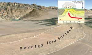
Despite lying in arid desert and being the site of rapidly growing, elongated folds of stratified rock called anticlines, the Tarim Basin region features huge flat surfaces that have been beveled across the tops of those folds. The folds are caused by the ongoing convergence between India and Asia. Some anticlines have risen 3 miles in less than 2 million years—the blink of an eye in geologic time. And despite the desert climate and rapid uplift, huge expanses—hundreds of square miles—have been beveled by rivers. Today these rivers lie in narrow gorges cut across these growing folds.
So how did they erode such huge areas in the recent past, geologically speaking?
To answer that question, graduate student and lead author Aaron Bufe turned to St. Anthony Falls Laboratory (SAFL) in Minneapolis. There, with SAFL director and co-author Chris Paola, Bufe built a 160-square-foot stream table that could progressively “grow” a mechanically driven fold across which small “rivers” flowed, causing erosion. The experiment simulated conditions believed to be the cause of the beveling—the most recent episode of which occurred during the period of deglaciation following the last Ice Age, about 18,000 years ago. The researchers’ findings appear in the journal Nature Geoscience.
“The beveling has been pulsed through time, so we think that it was climatically modulated,” co-author Burbank explained. “When there is more discharge of sediment and water in the rivers, that’s when the beveling had to take place. But it had to be incredibly powerful and effective because of the huge areas—up to 77 square miles on a single fold—that were eroded.”
This erosion was so effective due to a process called channel switching. When the fluctuating flow of heavy sediment gets trapped in the channel and the river floods again, the water is diverted by the trapped sediment, so it moves laterally into another area.
“This sort of channel switching had to happen at a prolonged, rapid and spatially large scale for it to jump across and be able to erode such broad beveled zones,” Burbank said. “We hypothesized that when there was more sediment, the channel switched positions more often and therefore a larger fraction of the fold was beveled off.”
To test the hypothesis, Bufe designed an experiment to better understand how this process could occur and what combination of uplift rate, sediment flux, water flux and channel mobility could enable such erosion. During the up to 100 hours that a single experiment ran, the fold mechanism was incrementally cranked up as water ran over it. Every hour, the flow was stopped and the topography scanned with lasers to produce highly accurate measurements. Photos were taken every minute and analyzed by computer code that distinguished among wet sand, dry sand and water in order to track the shifting of the channels and how much of the area was beveled off through time.
“Our theory posited that the degree of fold beveling—rather than being simply incised vertically by the ‘river’—would be determined by the amount of channel mobility, how rapidly the channels switched back and forth across the stream table,” Burbank said. “Moreover, we thought that this mobility was likely to be a function of the sediment-to-water ratio: More sediment would cause more rapid channel shifting. And in fact, this is what the experiments showed.”
Reference:
Aaron Bufe et al. Fluvial bevelling of topography controlled by lateral channel mobility and uplift rate, Nature Geoscience (2016). DOI: 10.1038/ngeo2773
Note: The above post is reprinted from materials provided by University of California – Santa Barbara.


