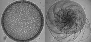
This image shows a holotype male, on the right, and allotype female, on the left. (Credit: Li S, Shih C, Wang C, Pang H, Ren D)
Scientists have found the oldest fossil depicting copulating insects in northeastern China, published November 6th in the open-access journal PLOS ONE by Dong Ren and colleagues at the Capital Normal University in China.
Fossil records of mating insects are fairly sparse, and therefore our current knowledge of mating position and genitalia orientation in the early stages of evolution is rather limited.
In this study, the authors present a fossil of a pair of copulating froghoppers, a type of small insect that hops from plant to plant much like tiny frogs. The well-preserved fossil of these two froghoppers showed belly-to-belly mating position and depicts the male reproductive organ inserting into the female copulatory structure.
This is the earliest record of copulating insects to date, and suggests that froghoppers’ genital symmetry and mating position have remained static for over 165 million years. Ren adds, “We found these two very rare copulating froghoppers which provide a glimpse of interesting insect behavior and important data to understand their mating position and genitalia orientation during the Middle Jurassic.”
Note : The above story is based on materials provided by Public Library of Science.
The lava flow steaming after rain. Credit: Image courtesy of Lancaster University
Scientists have made the first ever observations of how a rare type of lava continues moving almost a year after a volcanic eruption.
Researchers visiting the Puyehue-Cordón Caulle volcano in Chile in January this year found the obsidian lava flow was still moving, even though the volcano stopped erupting in April 2012.
The research by an international team of scientists, led by Dr Hugh Tuffen and Dr Mike James from the Lancaster Environment Centre at Lancaster University, is published in Nature Communications.
Obsidian lava is very thick and can barely flow, moving more like a glacier. This type of lava, rich in silica, forms a natural glass called obsidian when it cools and solidifies. This volcanic glass slowly inches forward as a thick, shattering crust of black rock that covers the oozing lava within.
Dr Tuffen said: “We found out that the lava was still oozing after almost a year and it advances between 1 and 3 metres a day. Although it moves slowly, it could speed up or collapse if it were to reach a steep hill, and The team, which included Professor Jon Castro from the University of Mainz and Dr Ian Schipper from the Victoria University of Wellington, also made new discoveries about how the obsidian lava flows, pointing the way towards a new model of how lavas advance.
Dr Tuffen said: “It looks like a solid cliff of crumbling rock up to 40 metres thick, that’s as thick as ten double-decker buses, but we found that hidden beneath this crust there is hot, slowly-flowing lava, at up to 900 °C, which can burst out of the edges of the lava flow and help it move forwards. This was previously thought to only occur in hot red flowing or basalt lava, but we have found that thick obsidian lava is actually pretty similar to its runnier cousins.”
Although seldom seen, obsidian lava can be erupted at the end of some of the largest and most explosive eruptions on Earth, including supervolcanoes such as Yellowstone and the largest eruption of the 20th century, at Katmai in Alaska. However, the most recent opportunities to see obsidian lava moving have been the last three eruptions at Puyehue-Cordón Caulle volcano in Chile in 2011, 1960 and 1921. Obsidian from lava flows is strewn over many archaeological sites worldwide, as it was long a highly-prized and traded material used for knives, arrowheads and cutting tools. It still has surgical applications due to its remarkably sharp cutting edges.
Dr Tuffen is funded by the Royal Society.
Video
Note : The above story is based on materials provided by Lancaster University.
This skull, which includes pieces of real fossil, shows the unique features of this new tyrannosaur. (Credit: Mark Loewen, NHMU)
A remarkable new species of tyrannosaur has been unearthed in Grand Staircase-Escalante National Monument (GSENM), southern Utah. The huge carnivore inhabited Laramidia, a landmass formed on the western coast of a shallow sea that flooded the central region of North America, isolating western and eastern portions of the continent for millions of years during the Late Cretaceous Period, between 95-70 million years ago. The newly discovered dinosaur, belonging to the same evolutionary branch as the famous Tyrannosaurus rex, was announced today in the open-access scientific journal PLOS ONE and unveiled on exhibit in the Past Worlds Gallery at the Natural History Museum of Utah at the Rio Tinto Center in Salt Lake City, Utah.
Among tyrannosaurs, a group of small to large-bodied, bipedal carnivorous dinosaurs including T. rex that lived during the Jurassic and Cretaceous periods, the newly discovered species, Lythronax argestes, possesses several unique features, a short narrow snout with a wide back of the skull with forward-oriented eyes. Lythronax translates as “king of gore,” and the second part of the name, argestes, refers to its geographic location in the American Southwest. Previously, paleontologists thought this type of wide-skulled tyrannosaurid only appeared 70 million years ago, whereas Lythronax shows it had evolved at least 10 million years earlier.
The study, funded in large part by the Bureau of Land Management and the National Science Foundation, was led by Dr. Mark Loewen, research associate at the Natural History Museum of Utah, and adjunct assistant professor in the Department of Geology and Geophysics at the University of Utah. Additional collaborative authors include Dr. Randall Irmis (Natural History Museum of Utah and Dept. of Geology and Geophysics, University of Utah), Dr. Joseph Sertich (Denver Museum of Nature & Science), Dr. Philip Currie (University of Alberta), and Dr. Scott Sampson (Denver Museum of Nature & Science). The skeleton was discovered by BLM employee Scott Richardson, and excavated by a joint NHMU-GSENM team.
Lythronax lived on Laramidia, along the western shores of the great seaway that separated North America; this landmass hosted a vast array of unique dinosaur species and served as the crucible of evolution for iconic dinosaur groups such as the horned and duck billed dinosaurs. This study also indicates that tyrannosaurid dinosaurs (the group of tyrannosaurs that includes T. rex) likely evolved in isolation on this island continent. Lythronax stands out from its contemporaries in having a much wider skull at the eyes and a narrow short snout, similar to its relative T. rex, which lived 10-12 million years later. Dr. Mark Loewen, the study’s lead author, noted, “The width of the back of the skull of Lythronax allowed it to see with an overlapping field of view — giving it the binocular vision — very useful for a predator and a condition we associate with T. rex.” Previously, paleontologists thought this type of wide-skulled tyrannosaurid only appeared ~70 million years ago, whereas Lythronax shows it had evolved at least 10 million years earlier
Paleontologists have recently determined that the dinosaurs of southern Laramidia (Utah, New Mexico, Texas, and Mexico), although belonging to the same major groups, differ at the species level from those on northern Laramidia (Montana, Wyoming, the Dakotas, and Canada). Lythronax and its tyrannosaurid relatives on southern Laramidia are more closely related to each other than the long snouted forms from northern Laramidia.
Dr. Joseph Sertich, a co-author of the study, stated that, “Lythronax may demonstrate that tyrannosaurs followed a pattern similar to what we see in other dinosaurs from this age, with different species living in the north and south at the same time.”
These patterns of dinosaur distribution across Laramidia lead the researchers to ask what might have caused the divisions between the north and south, given that an enterprising dinosaur could have walked from Alaska to Mexico if given enough time. Dr. Randall Irmis, a study co-author, explained that by analyzing the evolutionary relationships, geologic age, and geographic distribution of tyrannosaurid dinosaurs, the team determined that “Lythronax and other tyrannosaurids diversified between 95-80 million years ago, during a time when North America’s interior sea was at its widest extent. The incursion of the seaway onto large parts of low-lying Laramidia would have separated small areas of land from each other, allowing different species of dinosaurs to evolve in isolation on different parts of the landmass.” As the seaway gradually retreated after 80 million years ago, these differences in dinosaur species may have been reinforced by climate variations, differences in food sources (different prey and plants), and other factors. This hypothesis explains why the iconic Late Cretaceous dinosaurs of western North America are so different from those of the same age on other continents.
A Treasure Trove of Dinosaurs on the Lost Continent of Laramidia
Lythronax was discovered in Grand Staircase-Escalante National Monument (GSENM), which encompasses 1.9 million acres of high desert terrain in south-central Utah. This vast and rugged region, part of the National Landscape Conservation System administered by the Bureau of Land Management (BLM), was the last major area in the lower 48 states to be formally mapped by cartographers. Today GSENM is the largest national monument in the United States. Co-author Dr. Scott Sampson proclaimed that, “Grand Staircase-Escalante National Monument is the last great, largely unexplored dinosaur boneyard in the lower 48 states.”
During the past fourteen years, crews from the Natural History Museum of Utah, GSENM, the Denver Museum of Nature & Science, and several other partner institutions (for example, the Raymond Alf Museum of Paleontology and Utah Geological Survey) have unearthed a new assemblage of more than a dozen species dinosaurs in GSENM. In addition to Lythronax, the collection includes a variety of other plant-eating dinosaurs — among them duck-billed hadrosaurs, armored ankylosaurs, dome-headed pachycephalosaurs, and two other horned dinosaurs, Utahceratops and Kosmoceratops — together with carnivorous dinosaurs great and small, from “raptor-like” predators such as Talos, to another large tyrannosaur named Teratophoneus. Amongst the other fossil discoveries are fossil plants, insect traces, snails, clams, fishes, amphibians, lizards, turtles, crocodiles, and mammals. Together, this diverse bounty of fossils is offering one of the most comprehensive glimpses into a Mesozoic ecosystem. Remarkably, virtually all of the identifiable dinosaur remains found in GSENM belong to new species.
Dr. Philip Currie, another co-author, stated that, “Lythronax is a wonderful example of just how much more we have to learn about with world of dinosaurs. Many more exciting fossils await discovery in Grand Staircase-Escalante National Monument.”
Note : The above story is based on materials provided by University of Utah.
This shows thin slices of basalt with a diameter of just a fraction of a millimeter were subjected to high pressure in a diamond anvil cell. This sample has been molten and subsequently probed with X-rays three times. (Credit: Chrystèle Sanloup, University of Edinburgh)
Using the world’s most brilliant X-ray source, scientists have for the first time peered into molten magma at conditions of the deep Earth mantle. The analysis at DESY’s light source PETRA III revealed that molten basalt changes its structure when exposed to pressure of up to 60 gigapascals (GPa), corresponding to a depth of about 1400 kilometres below the surface. At such extreme conditions, the magma changes into a stiffer and denser form, the team around first author Chrystèle Sanloup from the University of Edinburgh reports in the scientific journal Nature.
The findings support the concept that the early Earth’s mantle harboured two magma oceans, separated by a crystalline layer. Today, these presumed oceans have crystallised, but molten magma still exists in local patches and maybe thin layers in the mantle.
“Silicate liquids like basaltic magma play a key role at all stages of deep Earth evolution, ranging from core and crust formation billions of years ago to volcanic activity today,” Sanloup emphasised. To investigate the behaviour of magma in the deep mantle, the researchers squeezed small pieces of basalt within a diamond anvil cell and applied up to roughly 600,000 times the standard atmospheric pressure. “But to investigate basaltic magma as it still exists in local patches within the Earth’s mantle, we first had to melt the samples,” explained co-author Zuzana Konôpková from DESY, who supported the experiments at the Extreme Conditions Beamline (ECB), P02 at PETRA III.
The team used two strong infrared lasers that each concentrated a power of up to 40 Watts onto an area just 20 micrometres (millionths of a metre) across — that is about 2000 times the power density at the surface of the sun. A clever alignment of the laser optics allowed the team to shoot the heating lasers right through the diamond anvils. With this unique setup, the basalt samples could be heated up to 3,000 degrees Celsius in just a few seconds, until they were completely molten. To avoid overheating of the diamond anvil cell which would have skewed the X-ray measurements, the heating laser was only switched on for a few seconds before and during the X-ray diffraction patterns were taken. Such short data collection times, crucial for this kind of melting experiments, are only possible thanks to the high X-ray brightness at the ECB. “For the first time, we could study structural changes in molten magma over such a wide range of pressure,” said Konôpková.
The powerful X-rays show that the so-called coordination number of silicon, the most abundant chemical element in magmas, in the melt increases from 4 to 6 under high pressure, meaning that the silicon ions rearrange into a configuration where each has six nearest oxygen neighbours instead of the usual four at ambient conditions. As a result, the basalt density increases from about 2.7 grams per cubic centimetre (g/ccm) at low pressure to almost 5 g/ccm at 60 GPa. “An important question was how this coordination number change happens in the molten state, and how that affects the physical and chemical properties,” explained Sanloup. “The results show that the coordination number changes from 4 to 6 gradually from 10 GPa to 35 GPa in magmas, and once completed, magmas are much stiffer, that is much less compressible.” In contrast, in mantle silicate crystals, the coordination number change occurs abruptly at 25 GPa, which defines the boundary between the upper and lower mantle.
This behaviour allows for the peculiar possibility of layered magma oceans in the early Earth’s interior. “At low pressure, magmas are much more compressible than their crystalline counterparts, while they are almost as stiff above 35 GPa,” explained Sanloup. “This implies that early in the history of the Earth, when it started crystallising, magmas may have been negatively buoyant at the bottom of both, upper and lower mantle, resulting in the existence of two magma oceans, separated by a crystalline layer, as has been proposed earlier by other scientists.”
At the high pressure of the lower Earth mantle, the magma becomes so dense that rocks do not sink into it anymore but float on top. This way a crystallised boundary between an upper and a basal magma ocean could have formed within the young Earth. The existence of two separate magma oceans had been postulated to reconcile geochronological estimates for the duration of the magma ocean era with cooling models for molten magma. While the geochronological estimates yield a duration of a few ten million years for the magma ocean era, cooling models show that a single magma ocean would have cooled much quicker, within just one million years. A crystalline layer would have isolated the lower magma ocean thermally and significantly delayed its cooling down. Today, there are still remnants of the basal magma ocean in the form of melt pockets detected atop the Earth’s core by seismology.
Note : The above story is based on materials provided by Deutsches Elektronen-Synchrotron DESY, via EurekAlert!, a service of AAAS.
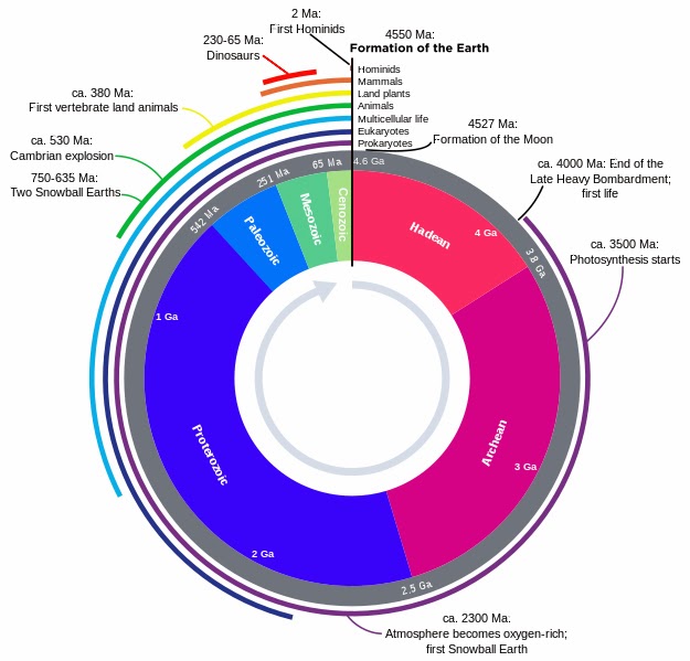
The geological clock: a projection of Earth’s 4,5 Ga history on a clock Author: Woudloper Derivative work: Hardwigg Wikipedia
The Cenozoic Era (also Cænozoic, Caenozoic or Cainozoic; meaning “new life”, from Greek καινός kainos “new”, and ζωή zoe “life”) is the current and most recent of the three Phanerozoic geological eras, following the Mesozoic Era and covering the period from 66 million years ago to the present.
The era began in the wake of the Cretaceous-Paleogene extinction event (K-Pg event) at the end of the Cretaceous that saw the demise of the last non-avian dinosaurs (as well as many other terrestrial and marine flora and fauna) at the end of the Mesozoic. The Cenozoic is also known as the Age of Mammals, because the extinction of many groups allowed mammals to greatly diversify.
Early in the Cenozoic, following the K-Pg event, the planet was dominated by relatively small fauna, including small mammals, birds, reptiles, and amphibians. From a geological perspective, it did not take long for mammals and birds to greatly diversify in the absence of the large reptiles that had dominated during the Mesozoic. Some birds grew larger than the average human. This group became known as the “terror birds,” and were formidable predators. Mammals came to occupy almost every available niche (both marine and terrestrial), and some also grew very large, attaining sizes not seen in most of today’s mammals.
Climate-wise, the Earth had begun a drying and cooling trend, culminating in the glaciations of the Pleistocene Epoch, and partially offset by the Paleocene-Eocene Thermal Maximum. The continents also began looking roughly familiar at this time and moved into their current positions.
Subdivisions
The Cenozoic is divided into three periods: The Paleogene, Neogene, and Quaternary; and seven epochs: The Paleocene, Eocene, Oligocene, Miocene, Pliocene, Pleistocene, and Holocene. The Quaternary Period was officially recognized by the International Commission on Stratigraphy in June 2009, and the former Tertiary Period was officially disused in 2004. The common use of epochs during the Cenozoic helps paleontologists better organize and group the many significant events that occurred during this comparatively short interval of time. There is also more detailed knowledge of this era than any other because of the relatively young strata associated with it.
Tectonics
Geologically, the Cenozoic is the era when the continents moved into their current positions. Australia-New Guinea, having split from Pangea during the early Cretaceous, drifted north and, eventually, collided with South-east Asia; Antarctica moved into its current position over the South Pole; the Atlantic Ocean widened and, later in the era, South America became attached to North America.
India collided with Asia 55 to 45 million years ago; Arabia collided with Eurasia, closing the Tethys ocean, around 35 million years ago.
Stratigraphy
**The concepts of Tertiary and Quaternary have an interesting history. In the 1760s and 1770s a geologist named Giovanni Arduino was studying the rocks and minerals in Tuscany. He classified mountains according to the type of rocks that he found in them. Unfossiliferous schists, granites, and basalts (all volcanic rocks) that formed the cores of large mountains he called Primitive. Fossil-rich rocks of limestone and clay that were found on the flanks of mountains over the Primitive rocks were called Secondary. Finally, there were another group of fossiliferous rocks of limestones and sandstones lying over the Secondary rocks and forming the foothills of the mountains that Anduino called Tertiary. So at first, Tertiary referred to a certain type of rock found in the area of Tuscany. But later, geologists used the fossils found in the Tertiary rocks there to recognize rocks of the same age elsewhere. Rocks with the same species of fossils were the same age.
Extensive Tertiary age rocks were recognized in the Paris Basin, which is the area around Paris, France. In the 1820s and 1830s Charles Lyell, a noted English geologist who had a great influence on Charles Darwin, subdivided the Tertiary rocks of the Paris Basin on their fossils. Lyell came up with an ingenious idea. He noticed that the rocks at the top of the section had a very high percentage of fossils of living mollusc species. Those at the bottom of the section had very few living forms. He deduced that this difference was because of the extinction of older forms and the evolution of living forms during the time that the rocks were being deposited. He divided the Tertiary rocks into three sub-ages: the Pliocene, the Miocene, and the Eocene. 90% of the fossil molluscs in Pliocene rocks were living today. In the Miocene rocks, only 18% of the molluscs were of living species, and in Eocene rocks, only 9.5%.
These subdivisions of the Tertiary have been correlated around the world using the fossil species in them. Rocks with the same species as Lyell’s Eocene, are considered to be the same age as those in the Paris Basin. The same goes for the other subdivisions. Some time later it was noted that in areas other than the Paris Basin, there were rocks that seemed to be from time periods that were not represented in Lyell’s sequence. This was because during those periods there had been no deposition in what would later be the Paris Basin. These two periods, later designated Oligocene and Paleocene, were inserted into the Tertiary in their proper places.
Climate
The Paleocene–Eocene Thermal Maximum of 55.8 million years ago was a significant global warming event. However, since the Azolla event of 49 million years ago, the Cenozoic Era has been a period of long-term cooling. After the tectonic creation of Drake Passage, when South America fully detached from Antarctica during the Oligocene, the climate cooled significantly due to the advent of the Antarctic Circumpolar Current which brought cool deep Antarctic water to the surface. The cooling trend continued in the Miocene, with relatively short warmer periods. When South America became attached to North America creating the Isthmus of Panama, the Arctic region cooled due to the strengthening of the Humboldt and Gulf Stream currents, eventually leading to the glaciations of the Quaternary ice age, the current interglacial of which is the Holocene Epoch.
Life
During the Cenozoic, mammals proliferated from a few small, simple, generalized forms into a diverse collection of terrestrial, marine, and flying animals, giving this period its other name, the Age of Mammals, despite the fact that birds still outnumbered mammals two to one. The Cenozoic is just as much the age of savannas, the age of co-dependent flowering plants and insects, and the age of birds. Grass also played a very important role in this era, shaping the evolution of the birds and mammals that fed on it. One group that diversified significantly in the Cenozoic as well were the snakes. Evolving in the Cenozoic, the variety of snakes increased tremendously, resulting in many colubrids, following the evolution of their current primary prey source, the rodents.
In the earlier part of the Cenozoic, the world was dominated by the gastornid birds, terrestrial crocodiles like Pristichampsus, and a handful of primitive large mammal groups like uintatheres, mesonychids, and pantodonts. But as the forests began to recede and the climate began to cool, other mammals took over. The Cenozoic is full of mammals both strange and familiar, including chalicotheres, creodonts, whales, primates, entelodonts, saber-toothed cats, mastodons and mammoths, three-toed horses, giant rhinoceros like Indricotherium, and brontotheres.
Note : The above story is based on materials provided by Wikipedia
** Stratigraphy story is based on materials provided by University of California Museum of Paleontology
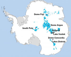
This shows Antarctic locations (in bright blue) where 1.5 million years old ice could exist. The figure is modified from Van Liefferinge and Pattyn (Climate of the Past, 2013). Credit: Van Liefferinge and Pattyn
How far into the past can ice-core records go? Scientists have now identified regions in Antarctica they say could store information about Earth’s climate and greenhouse gases extending as far back as 1.5 million years, almost twice as old as the oldest ice core drilled to date. The results are published today in Climate of the Past, an open access journal of the European Geosciences Union (EGU).
By studying the past climate, scientists can understand better how temperature responds to changes in greenhouse-gas concentrations in the atmosphere. This, in turn, allows them to make better predictions about how climate will change in the future.
“Ice cores contain little air bubbles and, thus, represent the only direct archive of the composition of the past atmosphere,” says Hubertus Fischer, an experimental climate physics professor at the University of Bern in Switzerland and lead author of the study. A 3.2-km-long ice core drilled almost a decade ago at Dome Concordia (Dome C) in Antarctica revealed 800,000 years of climate history, showing that greenhouse gases and temperature have mostly moved in lockstep. Now, an international team of scientists wants to know what happened before that.
At the root of their quest is a climate transition that marine-sediment studies reveal happened some 1.2 million years to 900,000 years ago. “The Mid Pleistocene Transition is a most important and enigmatic time interval in the more recent climate history of our planet,” says Fischer. The Earth’s climate naturally varies between times of warming and periods of extreme cooling (ice ages) over thousands of years. Before the transition, the period of variation was about 41 thousand years while afterwards it became 100 thousand years. “The reason for this change is not known.”
Climate scientists suspect greenhouse gases played a role in forcing this transition, but they need to drill into the ice to confirm their suspicions. “The information on greenhouse-gas concentrations at that time can only be gained from an Antarctic ice core covering the last 1.5 million years. Such an ice core does not exist yet, but ice of that age should be in principle hidden in the Antarctic ice sheet.”
As snow falls and settles on the surface of an ice sheet, it is compacted by the weight of new snow falling on top of it and is transformed into solid glacier ice over thousands of years. The weight of the upper layers of the ice sheet causes the deep ice to spread, causing the annual ice layers to become thinner and thinner with depth. This produces very old ice at depths close to the bedrock.
However, drilling deeper to collect a longer ice core does not necessarily mean finding a core that extends further into the past. “If the ice thickness is too high the old ice at the bottom is getting so warm by geothermal heating that it is melted away,” Fischer explains. “This is what happens at Dome C and limits its age to 800,000 years.”
To complicate matters further, horizontal movements of the ice above the bedrock can disturb the bottommost ice, causing its annual layers to mix up.
“To constrain the possible locations where such 1.5 million-year old – and in terms of its layering undisturbed – ice could be found in Antarctica, we compiled the available data on climate and ice conditions in the Antarctic and used a simple ice and heat flow model to locate larger areas where such old ice may exist,” explains co-author Eric Wolff of the British Antarctic Survey, now at the University of Cambridge.
The team concluded that 1.5 million-year old ice should still exist at the bottom of East Antarctica in regions close to the major Domes, the highest points on the ice sheet, and near the South Pole, as described in the new Climate of the Past study. These results confirm those of another study, also recently published in Climate of the Past.
Crucially, they also found that an ice core extending that far into the past should be between 2.4 and 3-km long, shorter than the 800,000-year-old core drilled in the previous expedition.
The next step is to survey the identified drill sites to measure the ice thickness and temperature at the bottom of the ice sheet before selecting a final drill location.
“A deep drilling project in Antarctica could commence within the next 3-5 years,” Fischer states. “This time would also be needed to plan the drilling logistically and create the funding for such an exciting large-scale international research project, which would cost around 50 million Euros.”
Note : The above story is based on materials provided by European Geosciences Union
Map showing 2009–2011 earthquakes located in this study (red circles), gas injection wells active since 2004 (yellow squares), and focal mechanisms for regional events (beach balls). A series of small quakes occurred in the same region in 1979 and 1980 (green circles) and may have been related to injection of water for enhanced oil recovery. (Credit: Sources: EarthScope, Texas Railroad Commission, S.T. Harding, and St. Louis University. Illustration: Cliff Frohlich/University of Texas at Austin)
A new study correlates a series of small earthquakes near Snyder, Texas between 2006 and 2011 with the underground injection of large volumes of gas, primarily carbon dioxide (CO2) — a finding that is relevant to the process of capturing and storing CO2 underground.
Although the study suggests that underground injection of gas triggered the Snyder earthquakes, it also points out that similar rates of injections have not triggered comparable quakes in other fields, bolstering the idea that underground gas injection does not cause significant seismic events in many geologic settings.
No injuries or severe damage were reported from the quakes identified in the study.
The study represents the first time underground gas injection has been correlated with earthquakes greater than magnitude 3.
The results, from Wei Gan and Cliff Frohlich at The University of Texas at Austin’s Institute for Geophysics, appear this week in an online edition of the journal Proceedings of the National Academy of Sciences.
The study focused on an area of northwest Texas with three large oil and gas fields — the Cogdell field, the Salt Creek field and the Scurry Area Canyon Reef Operators Committee unit (SACROC) — which have all produced petroleum since the 1950s.
Operators began injecting CO2 in the SACROC field in 1971 to boost petroleum production, a process known as CO2 Enhanced Oil Recovery (CO2 EOR). Operators began CO2 EOR in the Cogdell field in 2001, with a significant increase starting in 2004. Because CO2 has been injected at large volumes for many years, the Department of Energy has funded research in this region to explore the potential impacts of carbon capture and storage (CCS), a proposed technique for reducing greenhouse gas emissions by capturing CO2 and injecting it deep underground for long-term storage.
This latest study was funded by the U.S. Geological Survey and the National Natural Science Foundation of China.
Using a high-resolution temporary network of seismometers, Gan and Frohlich identified 93 earthquakes in the Cogdell area from March 2009 to December 2010, three of which were greater than magnitude 3. An even larger earthquake, with magnitude 4.4, occurred in Cogdell in September 2011. Using data on injections and extractions of fluids and gases, they concluded that the earthquakes were correlated with the increase in CO2 EOR in Cogdell.
“What’s interesting is we have an example in Cogdell field, but there are other fields nearby that have experienced similar CO2 flooding without triggering earthquakes,” said Frohlich, associate director of the Institute for Geophysics, a research unit in the Jackson School of Geosciences. “So the question is: Why does it happen in one area and not others?”
In a paper published last year in the Proceedings of the National Academy of Sciences, Stanford University earthquake researchers Mark Zoback and Steven Gorelick argued “there is a high probability that earthquakes will be triggered by injection of large volumes of CO2” during CCS.
“The fact that the different fields responded differently to CO2 injection and that no other gas injection sites in the world have been linked to earthquakes with magnitudes as large as 3 suggest that despite Zoback and Gorelick’s concerns, it is possible that in many locations large-volume CO2 injection may not induce earthquakes,” said Frohlich.
Frohlich suggests one possible explanation for the different response to gas injection in the three fields might be that there are geological faults in the Cogdell area that are primed and ready to move when pressures from large volumes of gas reduce friction on these faults. The other two fields might not have such faults.
Frohlich suggests an important next step in understanding seismic risks for proposed CCS projects would be to create geological models of Cogdell and other nearby fields to better understand why they respond differently to gas injection.
Gan and Frohlich analyzed seismic data collected between March 2009 and December 2010 by the EarthScope USArray Program, a National Science Foundation-funded network of broadband seismometers deployed from the Canadian border to the Gulf of Mexico. Because of the high density of instruments, they were able to detect earthquakes down to magnitude 1.5, too weak for people to feel at the surface and many of which were not detected by the U.S. Geological Survey’s more limited seismic network.
Using the USArray data, the researchers identified and located 93 well-recorded earthquakes. Most occurred in several northeast-southwest trending linear clusters, which might indicate the presence of previously unidentified faults. Three of the quakes identified in the USArray data were greater than magnitude 3. According to U.S. Geological Survey observations for the same area from 2006 to 2011, 18 earthquakes greater than magnitude 3 occurred in the study area.
Gan and Frohlich also evaluated data on injections and extractions of oil, water and gas in the study area collected by the Texas Railroad Commission, the state agency that regulates oil and gas operations. Since 1990, rates of liquid injection and extraction, as well as gas produced, remained fairly constant in all three oil and gas fields. The only significant change was a substantial increase in injection rates of gas, primarily CO2, in the Cogdell field starting in 2004.
Previous work by Frohlich and others has shown that underground injection of liquids can induce earthquakes.
This research was partially supported by National Natural Science Foundation of China (Grant 41174076) and by the U.S. Geological Survey (Award G13AP00023).
The University of Texas at Austin is committed to transparency and disclosure of all potential conflicts of interest of its researchers. Frohlich has no research support from the petroleum industry, but he has consulted for geophysical service companies concerning seismic risks for dams, power plants, water pipelines and petroleum fields. Gan has no research support from the petroleum industry.
Note : The above story is based on materials provided by University of Texas at Austin.
The geological clock: a projection of Earth’s 4,5 Ga history on a clock Author: Woudloper Derivative work: Hardwigg Wikipedia
The Mesozoic Era is an interval of geological time from about 252 to 66 million years ago. It is also called the Age of Reptiles, a phrase introduced by the 19th century paleontologist Gideon Mantell who viewed it as dominated by reptiles such as Iguanadon, Megalosaurus, Plesiosaurus and what are now called Pseudosuchia.
Mesozoic means “middle life”, deriving from the Greek prefix meso-/μεσο- for “between” and zōon/ζῷον meaning “animal” or “living being”. It is one of three geologic eras of the Phanerozoic Eon, preceded by the Paleozoic (“ancient life”) and succeeded by the Cenozoic (“new life”). The era is subdivided into three major periods: the Triassic, Jurassic, and Cretaceous, which are further subdivided into a number of epochs and stages.
The era began in the wake of the Permian–Triassic extinction event, the largest well-documented mass extinction in Earth’s history, and ended with the Cretaceous–Paleogene extinction event, another mass extinction which is known for having killed off non-avian dinosaurs, as well as other plant and animal species.
The Mesozoic was a time of significant tectonic, climate and evolutionary activity. The era witnessed the gradual rifting of the supercontinent Pangaea into separate landmasses that would eventually move into their current positions. The climate of the Mesozoic was varied, alternating between warming and cooling periods. Overall, however, the Earth was hotter than it is today.
Non-avian dinosaurs appeared in the Late Triassic and became the dominant terrestrial vertebrates early in the Jurassic, occupying this position for about 135 million years until their demise at the end of the Cretaceous. Birds first appeared in the Jurassic, having evolved from a branch of theropod dinosaurs. The first mammals also appeared during the Mesozoic, but would remain small—less than 15 kg (33 lb)—until the Cenozoic.
Geologic periods
Following the Paleozoic, the Mesozoic extended roughly 186 million years, from 252.2 to 66 million years ago when the Cenozoic Era began. This time frame is separated into three geologic periods. From oldest to youngest:
Triassic (252.2 to 201.3 million years ago)
Jurassic (201.3 to 145 million years ago)
Cretaceous (145 to 66 million years ago)
The lower (Triassic) boundary is set by the Permian-Triassic extinction event, during which approximately 90% to 96% of marine species and 70% of terrestrial vertebrates became extinct. It is also known as the “Great Dying” because it is considered the largest mass extinction in the Earth’s history. The upper (Cretaceous) boundary is set at the Cretaceous-Tertiary (KT) extinction event (now more accurately called the Cretaceous–Paleogene (or K–Pg) extinction event), which may have been caused by the impactor that created Chicxulub Crater on the Yucatán Peninsula. Towards the Late Cretaceous large volcanic eruptions are also believed to have contributed to the Cretaceous–Paleogene extinction event. Approximately 50% of all genera became extinct, including all of the non-avian dinosaurs.
Paleogeography and tectonics
Compared to the vigorous convergent plate mountain-building of the late Paleozoic, Mesozoic tectonic deformation was comparatively mild. The sole major Mesozoic orogeny occurred in what is now the Arctic, creating the Innuitian orogeny, the Brooks Range, the Verkhoyansk and Cherskiy Ranges in Siberia, and the Khingan Mountains in Manchuria. This orogeny was related to the opening of the Arctic Ocean and subduction of the North China and Siberian cratons under the Pacific Ocean. Nevertheless, the era featured the dramatic rifting of the supercontinent Pangaea. Pangaea gradually split into a northern continent, Laurasia, and a southern continent, Gondwana. This created the passive continental margin that characterizes most of the Atlantic coastline (such as along the U.S. East Coast) today.
By the end of the era, the continents had rifted into nearly their present form. Laurasia became North America and Eurasia, while Gondwana split into South America, Africa, Australia, Antarctica and the Indian subcontinent, which collided with the Asian plate during the Cenozoic, the impact giving rise to the Himalayas.
Climate
The Triassic was generally dry, a trend that began in the late Carboniferous, and highly seasonal, especially in the interior of Pangaea. Low sea levels may have also exacerbated temperature extremes. With its high specific heat capacity, water acts as a temperature-stabilizing heat reservoir, and land areas near large bodies of water—especially the oceans—experience less variation in temperature. Because much of the land that constituted Pangaea was distant from the oceans, temperatures fluctuated greatly, and the interior of Pangaea probably included expansive areas of desert. Abundant red beds and evaporites such as halite support these conclusions, but evidence exists that the generally dry climate of the Triassic was punctuated by episodes of increased rainfall. Most important humid episodes were the Carnian Pluvial Event and one in the Rhaetian, few million years before the Triassic-Jurassic extinction event.
Sea levels began to rise during the Jurassic, which was probably caused by an increase in seafloor spreading. The formation of new crust beneath the surface displaced ocean waters by as much as 200 m (656 ft) more than today, which flooded coastal areas. Furthermore, Pangaea began to rift into smaller divisions, bringing more land area in contact with the ocean by forming the Tethys Sea. Temperatures continued to increase and began to stabilize. Humidity also increased with the proximity of water, and deserts retreated.
The climate of the Cretaceous is less certain and more widely disputed. Higher levels of carbon dioxide in the atmosphere are thought to have caused the world temperature gradient from north to south to become almost flat: temperatures were about the same across the planet. Average temperatures were also higher than today by about 10°C. In fact, by the middle Cretaceous, equatorial ocean waters (perhaps as warm as 20°C in the deep ocean) may have been too warm for sea life, and land areas near the equator may have been deserts despite their proximity to water. The circulation of oxygen to the deep ocean may also have been disrupted. For this reason, large volumes of organic matter that was unable to decompose accumulated, eventually being deposited as “black shale”.
Not all of the data support these hypotheses, however. Even with the overall warmth, temperature fluctuations should have been sufficient for the presence of polar ice caps and glaciers, but there is no evidence of either. Quantitative models have also been unable to recreate the flatness of the Cretaceous temperature gradient.
Different studies have come to different conclusions about the amount of oxygen in the atmosphere during different parts of the Mesozoic, with some concluding oxygen levels were lower than the current level (about 21%) throughout the Mesozoic, some concluding they were lower in the Triassic and part of the Jurassic but higher in the Cretaceous, and some concluding they were higher throughout most or all of the Triassic, Jurassic and Cretaceous.
Life
Conifers were the dominant terrestrial plants for most of the Mesozoic. Flowering plants appeared late in the era but did not become widespread until the Cenozoic.
Flora
The dominant land plant species of the time were gymnosperms, which are vascular, cone-bearing, non-flowering plants such as conifers that produce seeds without a coating. This is opposed to the earth’s current flora, in which the dominant land plants in terms of number of species are angiosperms. One particular plant genus, Ginkgo, is thought to have evolved at this time and is represented today by a single species, Ginko biloba. As well, the extant genus Sequoia is believed to have evolved in the Mesozoic.
Fauna
Dinosaurs were the dominant terrestrial vertebrates throughout much of the Mesozoic.
The extinction of nearly all animal species at the end of the Permian Period allowed for the radiation of many new lifeforms. In particular, the extinction of the large herbivorous pareiasaurs and carnivorous gorgonopsians left those ecological niches empty. Some were filled by the surviving cynodonts and dicynodonts, the latter of which subsequently became extinct. Some plant species had distributions that were markedly different from succeeding periods; for example, the Schizeales, a fern order, were skewed to the Northern Hemisphere in the Mesozoic, but are now better represented in the Southern Hemisphere.
Recent research indicates that the specialized animals that formed complex ecosystems, with high biodiversity, complex food webs and a variety of niches, took much longer to reestablish, recovery did not begin until the start of the mid-Triassic, 4M to 6M years after the extinction and was not complete until 30M years after the Permian-Triassic extinction event. Animal life was then dominated by large archosaurian reptiles: dinosaurs, pterosaurs, and aquatic reptiles such as ichthyosaurs, plesiosaurs, and mosasaurs.
The climatic changes of the late Jurassic and Cretaceous provided for further adaptive radiation. The Jurassic was the height of archosaur diversity, and the first birds and eutherian mammals also appeared. Angiosperms radiated sometime in the early Cretaceous, first in the tropics, but the even temperature gradient allowed them to spread toward the poles throughout the period. By the end of the Cretaceous, angiosperms dominated tree floras in many areas, although some evidence suggests that biomass was still dominated by cycad and ferns until after the Cretaceous–Paleogene extinction.
Some have argued that insects diversified with angiosperms because insect anatomy, especially the mouth parts, seems particularly well-suited for flowering plants. However, all major insect mouth parts preceded angiosperms and insect diversification actually slowed when they arrived, so their anatomy originally must have been suited for some other purpose.
As the temperatures in the seas increased, the larger animals of the early Mesozoic gradually began to disappear while smaller animals of all kinds, including lizards, snakes, and perhaps primates, evolved. The Cretaceous–Paleogene extinction event exacerbated this trend. The large archosaurs became extinct, while birds and mammals thrived, as they do today.
Note : The above story is based on materials provided by Wikipedia
This is a map of the blind-zone radius for California. Yellow and orange colors correspond to regions with small blind zones and red and dark-red colors correspond to regions with large blind zones. Credit: SRL
Earthquake early warning systems may provide the public with crucial seconds to prepare for severe shaking. For California, a new study suggests upgrading current technology and relocating some seismic stations would improve the warning time, particularly in areas poorly served by the existing network – south of San Francisco Bay Area to north Los Angeles and north of the San Francisco Bay Area.
A separate case study focuses on the utility of low cost sensors to create a high-density, effective network that can be used for issuing early warnings in Taiwan. Both studies appear in the November issue of the journal Seismological Research Letters (SRL).
“We know where most active faults are in California, and we can smartly place seismic stations to optimize the network,” said Serdar Kuyuk, assistant professor of civil engineering at Sakarya University in Turkey, who conducted the California study while he was a post-doctoral fellow at University of California (UC), Berkeley. Richard Allen, director of the Seismological Laboratory at UC Berkeley, is the co-author of this study.
Japan started to build its EEW system after the 1995 Kobe earthquake and performed well during the 2011 magnitude 9 Tohoku-Oki earthquake. While the U.S. Geological Survey(USGS)/Caltech Southern California Seismic and TriNet Network in Southern California was upgraded in response to the 1994 Northridge quake, the U.S is lagging behind Japan and other countries in developing a fully functional warning system.
“We should not wait until another major quake before improving the early warning system,” said Kuyuk.
Noting California’s recent law that calls for the creation of a statewide earthquake early warning (EEW) system, Kuyuk says “the study is timely and highlights for policymakers where to deploy stations for optimal coverage.” The approach maximizes the warning time and reduces the size of “blind zones” where no warning is possible, while also taking into account budgetary constraints.
Earthquake early warning systems detect the initiation of an earthquake and issue warning alerts of possible forthcoming ground shaking. Seismic stations detect the energy from the compressional P-wave first, followed by the shear and surface waves, which cause the intense shaking and most damage.
The warning time that any system generates depends on many factors, with the most important being the proximity of seismic stations to the earthquake epicenter. Once an alert is sent, the amount of warning time is a function of distance from the epicenter, where more distant locations receive more time.
Areas in “blind zones” do not receive any warning prior to arrival of the more damaging S-wave. The goal, writes Kuyuk and Allen, is to minimize the number of people and key infrastructure within the blind zone. For the more remote earthquakes, such as earthquakes offshore or in unpopulated regions, larger blind zones can be tolerated.
“There are large blind zones between the Bay Area and Los Angeles where there are active faults,” said Kuyuk. “Why? There are only 10 stations along the 150-mile section of the San Andreas Fault. Adding more stations would improve warning for people in these areas, as well as people in LA and the Bay Area should an earthquake start somewhere in between,” said Kuyuk.
Adding stations may not be so simple, according to Allen. “While there is increasing enthusiasm from state and federal legislators to build the earthquake early warning system that the public wants,” said Allen, “the reality of the USGS budget for the earthquake program means that it is becoming impossible to maintain the functionality of the existing network operated by the USGS and the universities.
“The USGS was recently forced to downgrade the telemetry of 58 of the stations in the San Francisco Bay Area in order to reduce costs,” said Allen. “While our SRL paper talks about where additional stations are needed in California to build a warning system, we are unfortunately losing stations.”
In California, the California Integrated Seismic Network (CISN) consists of multiple networks, with 2900 seismic stations at varying distances from each other, ranging from 2 to 100 km. Of the some 2900 stations, 377 are equipped to contribute to an EEW system.
Kuyuk and Allen estimate 10 km is the ideal distance between seismic stations in areas along major faults or near major cities. For other areas, an interstation distance of 20 km would provide sufficient warning. The authors suggest greater density of stations and coverage could be achieved by upgrading technology used by the existing stations, integrating Nevada stations into the current network, relocating some existing stations and adding new ones to the network.
The U.S. Geological Survey (USGS) and the Gordon and Betty Moore Foundation funded this study.
A Low-Cost Solution in Taiwan
In a separate study, Yih-Min Wu of National Taiwan University reports on the successful experiment to use low cost MEMS sensors to build a high-density seismic network to support an early warning system for Taiwan.
MEMS accelerometers are tiny sensors used in common devices, such as smart phones and laptops. These sensors are relatively cheap and have proven to be sensitive detectors of ground motion, particularly from large earthquakes.
The current EEW system in Taiwan consists of 109 seismic stations that can provide alerts within 20 seconds following the initial detection of an earthquake. Wu sought to reduce the time between earthquake and initial alert, thereby increasing the potential warning time.
The EEW research group at National Taiwan University developed a P-wave alert device named “Palert” that uses MEMS accelerometers for onsite earthquake early warning, at one-tenth the cost of traditional strong motion instruments.
From June 2012 to May 2013 Wu and his colleagues tested a network of 400 Palert devices deployed throughout Taiwan, primarily at elementary schools to take advantage of existing power and Internet connections and where they can be used to educate students about earthquake hazard mitigation.
During the testing period, the Palert system functioned similarly to the existing EEW system, which consists of the conventional strong motion instruments. With four times as many stations, the Palert network can provide a detailed shaking map for damage assessments, which it did for the March 2013 magnitude 6.1 Nantou quake.
Wu suggests the relatively low cost Palert device may have commercial potential and can be readily integrated into existing seismic networks to increase coverage density of EEW systems. In addition to China, Indonesia and Mexico, plans call for the Palert devices to be installed near New Delhi, India to test the feasibility of an EEW system there.
Note : The above story is based on materials provided by Seismological Society of America
Relationships between geosphere disturbances and mass extinction during the Late Permian and Early Triassic are shown. Credit: Science China Press
Relationships between geosphere disturbances and mass extinction during the Late Permian and Early Triassic are shown. Credit: Science China PressThe mysterious relationship between Pangea integration and the biggest mass extinction happened 250 million years ago was tackled by Professor YIN Hongfu and Dr. SONG Haijun from State Key Laboratory of Geobiology and Environmental Geology, China University of Geosciences (Wuhan). Their study shows that Pangea integration resulted in environmental deterioration which further caused that extinction. Their work, entitled “Mass extinction and Pangea integration during the Paleozoic-Mesozoic transition”, was published in Science Сhina Earth Sciences.2013, Vol 56(7).
The Pangea was integrated at about the beginning of Permian, and reached its acme during Late Permian to Early Triassic. Formation of the Pangea means that the scattered continents of the world gathered into one integrated continent with an area of nearly 200 million km2. Average thickness of such a giant continental lithosphere should be remarkably greater than that of each scattered continent. Equilibrium principle implies that the thicker the lithosphere, the higher its portion over the equilibrium level, hence the average altitude of the Pangea should be much higher than the separated modern continents. Correspondingly, all oceans gathered to form the Panthalassa, which should be much deeper than modern oceans. The acme of Pangea and Panthalassa was thus a period of high continent and deep ocean, which should inevitably induce great regression and influence the earth’s surface system, especially climate.
The Tunguss Trap of Siberia, the Emeishan Basalt erupted during the Pangea integration. Such global-scale volcanism should be evoked by mantle plume and related with integration of the Pangea. Volcanic activities would result in a series of extinction effects, including emission of large volume of CO2, CH4, NO2 and cyanides which would have caused green house effects, pollution by poisonous gases, damage of the ozone layer in the stratosphere, and enhancement the ultra-violet radiation.
Increase of CO2 concentration and other green house gases would have led to global warming, oxygen depletion and carbon cycle anomaly; physical and chemical anomalies in ocean (acidification, euxinia, low sulfate concentration, isotopic anomaly of organic nitrogen) and great regression would have caused marine extinction due to unadaptable environments, selective death and hypercapnia; continental aridity, disappearance of monsoon system and wild fire would have devastated the land vegetation, esp. the tropical rain forest.
The great global changes and mass extinction were the results of interaction among earth’s spheres. Deteriorated relations among lithosphere, atmosphere, hydrosphere, and biosphere (including internal factors of organism evolution itself) accumulated until they exceeded the threshold, and exploded at the Permian-Triassic transition time. Interaction among bio- and geospheres is an important theme. However, the processes from inner geospheres to earth’s surface system and further to organism evolution necessitate retardation in time and yields many uncertainties in causation. Most of the processes are now at a hypothetic stage and need more scientific examinations.
A Rice University-based team of geoscientists is going to great lengths — from Earth’s core to its atmosphere — to investigate the role that deep-Earth processes play in climate evolution over million-year timescales. Credit: Rice University
A Rice University-based team of geoscientists is going to great lengths—from Earth’s core to its atmosphere—to get to the bottom of a long-standing mystery about the planet’s climate.
“We want to know what controls long-term climate change on Earth, the oscillations between greenhouse and icehouse cycles that can last as long as tens of million years,” said Cin-Ty Lee, professor of Earth science at Rice and the principal investigator (PI) on a new $4.3 million, five-year federal grant from the National Science Foundation’s Frontiers in Earth-System Dynamics (FESD) Program.
“There are long periods where Earth is relatively cool, like today, where you have ice caps on the North and South poles, and there are also long periods where there are no ice caps,” Lee said. “Earth’s climate has oscillated between these two patterns for at least half a billion years. We want to understand what controls these oscillations, and we have people at universities across the country who are going to attack this problem from many angles.”
For starters, Lee distinguished between the type of climate change that he and his co-investigators are studying and the anthropogenic climate change that often makes headlines.
“We’re working on much longer timescales than what’s involved in anthropogenic climate change,” Lee said. “We’re interested in explaining processes that cycle over tens of millions of years.”
Lee described the research team as “a patchwork of free spirits” that includes bikers, birdwatchers and skateboarders who are drawn together by a common interest in studying the whole Earth dynamics of carbon exchange. The group has specialists in oceanography, petrology, geodynamics, biogeochemistry and other fields, and it includes more than a dozen faculty and students from the U.S., Europe and Asia. Rice co-PIs include Rajdeep Dasgupta, Gerald Dickens and Adrian Lenardic.
The team will focus on how carbon moves between Earth’s external and internal systems. On the external side, carbon is known to cycle between oceans, atmosphere, biosphere and soils on timescales ranging from a few days to a few hundred thousand years. On million-year to billion-year timescales, carbon in these external reservoirs interacts with reservoirs inside Earth, ranging from crustal carbon stored in ancient sediments preserved on the continents to carbon deep in Earth’s mantle.
“Because of these differences in timescales, carbon cycling at Earth’s surface is typically modeled independently from deep-Earth cycling,” Lee said. “We need to bring the two together if we are to understand long-term greenhouse-icehouse cycling.”
From the fossil record, scientists know that atmospheric carbon dioxide plays a vital role in determining Earth’s surface temperatures. Many studies have focused on how carbon moves between the atmosphere, oceans and biosphere. Lee said the FESD team will examine how carbon is removed from the surface and cycled back into the deep Earth, and it will also examine how volcanic eruptions bring carbon from the deep Earth to the surface. In addition, the team will examine the role that volcanic activity and plate tectonics may play in periodically releasing enormous volumes of carbon dioxide into the atmosphere.
One of several hypotheses that will be tested is whether Earth’s subduction zones may at times be dominated by continental arcs, and if so, whether the passage of magmas through ancient carbonates stored in the continental upper plate can amplify the volcanic flux of carbon.
“Long-term climate variability is intimately linked to whole-Earth carbon cycling,” Lee said. “Our task is to build up a clearer picture of how the inputs and outputs change through time.”
In addition to the Rice team, the project’s primary investigators include Jaime Barnes of the University of Texas at Austin, Jade Star Lackey of Pomona College, Michael Tice of Texas A&M University and Richard Zeebe of the University of Hawaii. Research affiliates include Steve Bergman of Shell, Mark Jellinek of the University of British Columbia, Tapio Schneider of the Swiss Federal Institute of Technology and Yusuke Yokoyama of the University of Tokyo.
Note : The above story is based on materials provided by Rice University
This is the 40-meter original skeleton, Argentinosaurus huinculensis reconstruction at Museo Municipal Carmen Funes, Plaza Huincul, Neuquén, Argentina. (Credit: Dr. Bill Sellers, The University of Manchester)
The Manchester team, working with scientists in Argentina, were able to laser scan a 40 metre-long skeleton of the vast Cretaceous Argentinosaurus dinosaur. Then using an advanced computer modeling technique involving the equivalent of 30,000 desktop computers they recreated its walking and running movements and tested its locomotion ability tested for the very first time.
The study, published in PLOS ONE, provides the first ever ‘virtual’ trackway of the dinosaur and disproves previous suggestions that the animal was inflated in size and could not have walked.
Dr Bill Sellers, lead researcher on the project from the University’s Faculty of Life Sciences, said: “If you want to work out how dinosaurs walked, the best approach is computer simulation. This is the only way of bringing together all the different strands of information we have on this dinosaur, so we can reconstruct how it once moved.”
Dr Lee Margetts, who also worked on the project, said: “We used the equivalent of 30,000 desktop computers to allow Argentinosaurus to take its first steps in over 94 million years. “The new study clearly demonstrates the dinosaur was more than capable of strolling across the Cretaceous planes of what is now Patagonia, South America.”
The team of scientists included Dr Rodolfo Coria from Carmen Funes Museum, Plaza Huincal, Argentina, who was behind the first physical reconstruction of this dinosaur that takes its name from the country where it was found. The dinosaur was so big it was named after a whole country.
Dr Phil Manning, from Manchester who contributed to the paper, said: “It is frustrating there was so little of the original dinosaur fossilized, making any reconstruction difficult. The digitization of such vast dinosaur skeletons using laser scanners brings Walking with Dinosaurs to life…this is science not just animation.”
Dr Sellers uses his own software (Gaitsym) to investigate locomotion both living and extinct animals have to overcome.
“The important thing is that these animals are not like any animal alive today and so we can’t just copy a modern animal,” he explained. “Our machine learning system works purely from the information we have on the dinosaur and predicts the best possible movement patterns.”
The dinosaur weighed 80 tonnes and the simulation shows that it would have reached just over 2 m/s — about 5 mph.
Dr Sellers said the research was important for understanding more about musculoskeletal systems and for developing robots.
He added: “All vertebrates from humans to fish share the same basic muscles, bones and joints. To understand how these function we can compare how they are used in different animals, and the most interesting are often those at extremes. Argentinosaurus is the biggest animal that ever walked on the surface of the Earth and understanding how it did this will tell us a lot about the maximum performance of the vertebrate musculoskeletal system. We need to know more about this to help understand how it functions in ourselves.
“Similarly if we want to build better legged robots then we need to know more about the mechanics of legs in a whole range of animals and nothing has bigger, more powerful legs than Argentinosaurus.”
The University of Manchester team now plans to use the method to recreate the steps of other dinosaurs including Triceratops, Brachiosaurus and T. rex.
Video :
Note : The above story is based on materials provided by University of Manchester.
The geological clock: a projection of Earth’s 4,5 Ga history on a clock Author: Woudloper Derivative work: Hardwigg Wikipedia
The Paleozoic (or Palaeozoic) Era is the earliest of three geologic eras of the Phanerozoic Eon, spanning from roughly 541 to 252.2 million years ago (ICS, 2004). It is the longest of the Phanerozoic eras, and is subdivided into six geologic periods (from oldest to least old): the Cambrian, Ordovician, Silurian, Devonian, Carboniferous, and Permian. The Paleozoic comes after the Neoproterozoic Era of the Proterozoic Eon, and is followed by the Mesozoic Era.
The Paleozoic was a time of dramatic geological, climatic, and evolutionary change. The Cambrian Period witnessed the most rapid and widespread diversification of life in Earth’s history, known as the Cambrian explosion, in which most modern phyla first appeared. Fish, arthropods, amphibians and reptiles all evolved during the Paleozoic. Life began in the ocean but eventually transitioned onto land, and by the late Paleozoic, it was dominated by various forms of organisms. Great forests of primitive plants covered the continents, many of which formed the coal beds of Europe and eastern North America. Towards the end of the era, large, sophisticated reptiles were dominant and the first modern plants (conifers) appeared.
The Paleozoic Era ended with the largest mass extinction in Earth’s history, the Permian–Triassic extinction event. The effects of this catastrophe were so devastating that it took life on land 30 million years into the Mesozoic to recover. Recovery of life in the sea may have been much faster.
Geology
In North America, the era began with deep sedimentary basins along the eastern, southeastern, and western sides of the continent, while the interior was dry land. As the era proceeded, the marginal seas periodically washed over the stable interior, leaving sedimentary deposits to mark their incursions. During the early part of the era, the area of exposed Precambrian, or shield, rocks in central Canada were eroding, supplying sediment to the basins from the interior. Beginning in the Ordovician Period, mountain building intermittently proceeded in the eastern part of the Appalachian region throughout the rest of the era, bringing in new sediments. Sediments washing from the Acadian Mountains filled the western part of the Appalachian basins to form the famous coal swamps of the Carboniferous Period. In North America carboniferous is not generally used instead the time is divided between Mississippian and Pennsylvanian period because of differences in the sedimentary rock deposited in this time. The Mississippian is characterized by limey sediments deposited in shallow seas, typically with abundant crinoidal fossils as in the Burlington fm. The Pennsylvanian typically is characterized by terrestrial sediments such as sands, shale and most importantly coal. Most of our oil and gas are obtained from Pennsylvanian sediments. Where this has been stripped, as in the Ozark domal region, oil is not typically available.
Paleoclimatic studies and evidence of glaciers indicate that central Africa was most likely in the polar regions during the early Paleozoic. During the early Paleozoic, the huge continent Gondwanaland had either formed or was forming. By mid-Paleozoic, the collision of North America and Europe produced the Acadian-Caledonian uplifts, and a subduction plate uplifted eastern Australia. By the late Paleozoic, continental collisions formed the supercontinent Pangaea and resulted in some of the great mountain chains, including the Appalachians, Urals, and mountains of Tasmania.
Tectonic activity
Land distribution early in the Paleozoic, around 540 Ma Author: Ron Blakey, NAU Geology
Geologically, the Paleozoic starts shortly after the breakup of a supercontinent called Pannotia. Throughout the early Paleozoic, the Earth’s landmass was broken up into a substantial number of continents. Towards the end of the era, the continents gathered together into a supercontinent called Pangaea, which included most of the Earth’s land area.
Climate
The Ordovician and Silurian periods were warm greenhouse periods, with the highest sea levels of the Paleozoic (200 m above today’s); the warm climate was interrupted only by a 30 million years cool period, the Early Palaeozoic Icehouse, culminating in the Hirnantian glaciation.
The early Cambrian climate was probably moderate at first, becoming warmer over the course of the Cambrian, as the second-greatest sustained sea level rise in the Phanerozoic got underway. However, as if to offset this trend, Gondwana moved south with considerable speed, so that, in Ordovician time, most of West Gondwana (Africa and South America) lay directly over the South Pole. The early Paleozoic climate was also strongly zonal, with the result that the “climate”, in an abstract sense became warmer, but the living space of most organisms of the time—the continental shelf marine environment—became steadily colder. However, Baltica (Northern Europe and Russia) and Laurentia (eastern North America and Greenland) remained in the tropical zone, while China and Australia lay in waters which were at least temperate. The Early Paleozoic ended, rather abruptly, with the short, but apparently severe, late Ordovician ice age. This cold spell caused the second-greatest mass extinction of Phanerozoic time. Over time, the warmer weather moved into the Paleozoic Era.
The middle Paleozoic was a time of considerable stability. Sea levels had dropped coincident with the ice age, but slowly recovered over the course of the Silurian and Devonian. The slow merger of Baltica and Laurentia, and the northward movement of bits and pieces of Gondwana created numerous new regions of relatively warm, shallow sea floor. As plants took hold on the continental margins, oxygen levels increased and carbon dioxide dropped, although much less dramatically. The north–south temperature gradient also seems to have moderated, or metazoan life simply became hardier, or both. At any event, the far southern continental margins of Antarctica and West Gondwana became increasingly less barren. The Devonian ended with a series of turnover pulses which killed off much of Middle Paleozoic vertebrate life, without noticeably reducing species diversity overall.
The late Paleozoic was a time which has left us a good many unanswered questions. The Mississippian began with a spike in atmospheric oxygen, while carbon dioxide plummeted to unheard-of lows. This destabilized the climate and led to one, and perhaps two, ice ages during the Carboniferous. These were far more severe than the brief Late Ordovician Ice; but, this time, the effects on world biota were inconsequential. By the Cisuralian, both oxygen and carbon dioxide had recovered to more normal levels. On the other hand, the assembly of Pangaea created huge arid inland areas subject to temperature extremes. The Lopingian is associated with falling sea levels, increased carbon dioxide and general climatic deterioration, culminating in the devastation of the Permian extinction.
Flora
An artist’s impression of early land plants
While macroscopic plant life appeared early in the Paleozoic and possibly late in the Neoproterozoic, it mostly remained aquatic until sometime in the Silurian and Devonian, when it began to transition onto dry land. Terrestrial flora reached its climax in the Carboniferous, when towering lycopsid rainforests dominated the tropical belt of Euramerica. Climate change caused the Carboniferous Rainforest Collapse which fragmented this habitat, diminishing the diversity of plant life in the late Carboniferous and Permian.
Fauna
A noteworthy feature of Paleozoic life is the sudden appearance of nearly all of the invertebrate animal phyla in great abundance at the beginning of the Cambrian. The first vertebrates appeared in the form of primitive fish, which greatly diversified in the Silurian and Devonian. The first animals to venture onto dry land were the arthropods. Some fish had lungs and strong, bony fins and could crawl onto the land also. The bones in their fins eventually evolved into legs and they became the first tetrapods. Amphibians were the dominant tetrapods until the mid-Carboniferous, when climate change greatly reduced their diversity. Later, reptiles prospered and continued to increase in number and variety by the late Permian.
Note : The above story is based on materials provided by Wikipedia
Most researchers believe that life originated in deep-sea hydrothermal vents. About 4 billion years ago, Earth was a watery planet; ocean stretched from pole to pole; any life synthesis would be dilated. It needed a protected basin. (Credit: Image courtesy of Texas Tech University)
It has baffled humans for millennia: how did life begin on planet Earth? Now, new research from a Texas Tech University paleontologist suggests it may have rained from the skies and started in the bowels of hell.
Sankar Chatterjee, Horn Professor of Geosciences and curator of paleontology at The Museum of Texas Tech University believes he has found the answer by connecting theories on chemical evolution with evidence related to our planet’s early geology.
“This is bigger than finding any dinosaur,” Chatterjee said. “This is what we’ve all searched for – the Holy Grail of science.”
Thanks to regular and heavy comet and meteorite bombardment of Earth’s surface during its formative years 4 billion years ago, the large craters left behind not only contained water and the basic chemical building blocks for life, but also became the perfect crucible to concentrate and cook these chemicals to create the first simple organisms.
He will present his findings Oct. 30 during the 125th Anniversary Annual Meeting of the Geological Society of America in Denver.
As well as discovering how ancient animals flew, Chatterjee discovered the Shiva Meteorite Crater, which was created by a 25-mile-wide meteorite that struck off the coast of India. This research concluded this giant meteorite wreaked havoc simultaneously with the Chicxulub meteorite strike near Mexico, finishing the dinosaurs 65 million years ago.
Ironically, Chatterjee’s latest research suggests meteorites can be givers of life as well as takers. He said that meteor and comet strikes likely brought the ingredients and created the right conditions for life on our planet. By studying three sites containing the world’s oldest fossils, he believes he knows how the first single-celled organisms formed in hydrothermal crater basins.
“When the Earth formed some 4.5 billion years ago, it was a sterile planet inhospitable to living organisms,” Chatterjee said. “It was a seething cauldron of erupting volcanoes, raining meteors and hot, noxious gasses. One billion years later, it was a placid, watery planet teeming with microbial life – the ancestors to all living things.”
Recipe for Living
As the basins filled, volcanically driven geothermal vents heated the water and created convection. The result was constant water movement, creating a thick primordial soup. (Credit: Image courtesy of Texas Tech University)
“For may years, the debate on the origins of life centered on the chemical evolution of living cells from organic molecules by natural processes. Chatterjee said life began in four steps of increasing complexity – cosmic, geological, chemical and biological.
In the cosmic stage, a still-forming Earth and our solar system took a daily pounding from rocky asteroids and icy comets between 4.1 to 3.8 billion years ago. Plate tectonics, wind and water have hidden evidence of this early onslaught on our planet, but ancient craters on the surfaces of Mars, Venus, Mercury and our moon show just how heavy the meteorite showers once were.
Larger meteorites that created impact basins of about 350 miles in diameter inadvertently became the perfect crucibles, he said. These meteorites also punched through the Earth’s crust, creating volcanically driven geothermal vents. Also, they brought the basic building blocks of life that could be concentrated and polymerized in the crater basins.
After studying the environments of the oldest fossil-containing rocks on Earth in Greenland, Australia and South Africa, Chatterjee said these could be remnants of ancient craters and may be the very spots where life began in deep, dark and hot environments.
Because of Earth’s perfect proximity to the sun, the comets that crashed here melted into water and filled these basins with water and more ingredients. This gave rise to the geological stage. As these basins filled, geothermal venting heated the water and created convection, causing the water to move constantly and create a thick primordial soup.
“The geological stage provides special dark, hot, and isolated environments of the crater basins with the hydrothermal vent systems that served as incubators for life,” he said. “Segregation and concentration of organic molecules by convective currents took place here, something like the kinds we find on the ocean floor, but still very different. It was a bizarre and isolated world that would seem like a vision of hell with the foul smells of hydrogen sulfide, methane, nitric oxide and steam that provided life-sustaining energy.”
Then began the chemical stage, Chatterjee said. The heat churning the water inside the craters mixed chemicals together and caused simple compounds to grow into larger, more complex ones.
Protecting Important Information
Eventually, the first life forms left the confines of the crater and ventured into the newly formed oceans. (Credit: Image courtesy of Texas Tech University)
Most likely, pores and crevices on the crater basins acted as scaffolds for concentrations of simple RNA and protein molecules, he said. Unlike a popular theory that believes RNA came first and proteins followed, Chatterjee believes RNA and proteins emerged simultaneously and were encapsulated and protected from the environment.
“The dual origin of the ‘RNA/protein’ world is more plausible in the vent environments than the popular ‘RNA world,’” he said. “RNA molecules are very unstable. In vent environments, they would decompose quickly. Some catalysts, such as simple proteins, were necessary for primitive RNA to replicate and metabolize. On the other hand, amino acids, from which proteins are made, are easier to make than RNA components.”
The question remains how loose RNA and protein material floating in this soup protected itself in a membrane. Chatterjee believes University of California professor David Deamer’s hypothesis that membranous material existed in the primordial soup. Deamer isolated fatty acid vesicles from the Murchison meteorite that fell in 1969 in Australia. The cosmic fatty bubbles extracted from the meteorite mimic cell membranes.
“Meteorites brought this fatty lipid material to early Earth,” Chatterjee said. “This fatty lipid material floated on top of the water surface of crater basins but moved to the bottom by convection currents. At some point in this process during the course of millions of years, this fatty membrane could have encapsulated simple RNA and proteins together like a soap bubble. The RNA and protein molecules begin interacting and communicating. Eventually RNA gave way to DNA – a much more stable compound – and with the development of the genetic code, the first cells divided.”
The final stage – the biological stage – represents the origin of replicating cells as they began to store, process and transmit genetic information to their daughter cells, Chatterjee said. Infinite combinations took place, and countless numbers must have failed to function before the secret of replication was broken and the proper selection occurred.
“These self-sustaining first cells were capable of Darwinian evolution,” he said. “The emergence of the first cells on the early Earth was the culmination of a long history of prior chemical, geological and cosmic processes.”
Chatterjee also believes that modern RNA-viruses and protein-rich prions that cause deadly diseases probably represent the evolutionary legacy of primitive RNA and protein molecules. They may be the oldest cellular particles that predated the first cellular life. Once cellular life evolved, RNA-viruses and prions became redundant, but survived as parasites on the living cells.
The problem with theories on the origins of life is that they don’t propose any experiments that lead to the emergence of cells, Chatterjee said. However, he suggested an experiment to recreate the ancient prebiotic world and support or refute his theory.
“If future experiments with membrane-bound RNA viruses and prions result in the creation of a synthetic protocell, it may reflect the plausible pathways for the emergence of life on early Earth,” he said.
What: Paper No. 300-5: Impact, RNA-Protein World and the Endoprebiotic Origin of Life https://gsa.confex.com/gsa/2013AM/webprogram/Paper222699.html
Note : The above story is based on materials provided by Texas Tech University. The original article was written by John Davis.
Bill Griffin. The sub-continental lithospheric mantle (SCLM) makes up the “roots” of the oldest continents, down to 150-250 km. Over the 3 billion years since they formed, the margins of SCLM blocks have been chemically “refertilized”, and they effectively control the location of many types of ore deposits.
As published this month in Nature Geoscience, researchers and industry partners have produced the first major ‘cat scan of the earth’. Their work reveals a new chart of the sub-continental lithosphere mantle and its potential mineral hotspots, visible only through a set of newly integrated technologies.
“You hear the term ‘the next frontier’ dropped frequently in the world of research,” says Distinguished Professor Sue O’Reilly, Director of the ARC Centre of Excellence for Core to Crust Fluid Systems, “but to understand what’s happening below the earth is inherently more difficult to study than something like space exploration, or the human body – so it really is a new field, evolving with our technology.
“Using geochemical and geophysical technologies to explore layers of the earth, our research has for the first time mapped two-thirds of the world’s sub-continental lithosphere mantle, and analysed the chemical composition below – revealing potential mineral hotspots 100-200km under the surface.”
Traditionally, ore deposits have been discovered through surface prospecting, but as most surface-facing sites have now been identified, mineral exploration companies are seeking new insight as to where the earth’s magma plumes might deliver their rich mineral endowment next.
The Core to Crust team show how basic scientific research can work hand in hand with key industries to deliver new insight into the earth’s architecture and evolution. The technological mix developed by the team has already had an impact on Australia’s mineral exploration industry, changing exploration strategies for a significant part of the industry by providing this new predictive framework for a range of economic deposits.
“Our earliest understandings of the lithosphere suggested that it was a smooth, consistent layer of the earth’s upper mantle, says O’Reilly. “Modern geophysical imaging shows otherwise – and we suggest that it is, in fact, a layer with many irregularities – and it’s in these sites that potential new mineral sources are lying in wait.”
To identify a new source, the team’s predictive framework analyses the chemical composition of the upper mantle in a location, to judge its metal endowment potential, the architecture of the lithosphere in that location and the geological precedents of similar areas.
“Pulling together information from international datasets of the last decade, including over 40,000 new geochemical analyses from the Macquarie laboratories, the study has revealed amazing secrets about the way the world works, how it has evolved, and now, a new predictive model for minerals exploration. We see the deep earth beneath the surface in four dimensions: height, width, depth, and time,” said O’Reilly.
“This is a textbook illustration of synergy between pure and strategic research – the work has revealed new fundamental information about the origin of the uppermost 200km shell of the Earth over 3.5 billion years, and is has provided the exploration industry with a new framework for global-scale exploration targeting.”
Note : The above story is based on materials provided by Macquarie University
RIVERSIDE, Calif. — Oxygen in the atmosphere and ocean rose dramatically about 600 million years ago, coinciding with the first proliferation of animal life. Since then, numerous short lived biotic events — typically marked by significant climatic perturbations — took place when oxygen concentrations in the ocean dipped episodically.
The most studied and extensive of these events occurred 93.9 million years ago. By looking at the chemistry of rocks deposited during that time period, specifically coupled carbon and sulfur isotope data, a research team led by University of California, Riverside biogeochemists reports that oxygen-free and hydrogen sulfide-rich waters extended across roughly five percent of the global ocean during this major climatic perturbation — far more than the modern ocean’s 0.1 percent but much less than previous estimates for this event.
The research suggests that previous estimates of oxygen-free and hydrogen sulfide-rich conditions, or “euxinia,” were too high. Nevertheless, the limited and localized euxinia were still sufficiently widespread to have dramatic effect on the entire ocean’s chemistry and thus biological activity.
“These conditions must have impacted nutrient availability in the ocean and ultimately the spatial and temporal distribution of marine life,” said team member Jeremy D. Owens, a former UC Riverside graduate student, who is now a postdoctoral scientist at the Woods Hole Oceanographic Institution. “Under low-oxygen environments, many biologically important metals and other nutrients are removed from seawater and deposited in the sediments on the seafloor, making them less available for life to flourish.”
“What makes this discovery particularly noteworthy is that we mapped out a landscape of bioessential elements in the ocean that was far more perturbed than we expected, and the impacts on life were big,” said Timothy W. Lyons, a professor of biogeochemistry at UCR, Owens’s former advisor and the principal investigator on the research project.
Study results appear online this week in the Proceedings of the National Academy of Sciences.
Across the event 93.9 million years ago, a major biological extinction in the marine realm has already been documented. Also associated with this event are high levels of carbon dioxide in the atmosphere, which are linked to elevated ocean and atmospheric temperatures. Associated consequences include likely enhanced global rainfall and weathering of the continents, which further shifted the chemistry of the ocean.
“Our work shows that even though only a small portion of the ocean contained toxic and metal-scavenging hydrogen sulfide, it was sufficiently large so that changes to the ocean’s chemistry and biology were likely profound,” Owens said. “What this says is that only portions of the ocean need to contain sulfide to greatly impact biota.”
For their analysis, the researchers collected seafloor mud samples, now rock, from multiple localities in England and Italy. They then performed chemical extraction on the samples to analyze the sulfur isotope compositions in order to estimate the chemistry of the global ocean.
According to the researchers, the importance of their study is elevated by the large amount of previous work on the same interval and thus the extensive availability of supporting data and samples. Yet despite all this past research, the team was able to make a fundamental discovery about the global conditions in the ancient ocean and their impacts on life.
“Today, we are facing rising carbon dioxide contents in the atmosphere through human activities, and the amount of oxygen in the ocean may drop correspondingly in the face of rising seawater temperatures,” Lyons said. “Oxygen is less soluble in warmer water, and there are already suggestions of such decreases. In the face of these concerns, our findings from the warm, oxygen-poor ancient ocean may be a warning shot about yet another possible perturbation to marine ecology in the future.”
Note : The above story is based on materials provided by University of California – Riverside
The Cretaceous bird tracks were found on a slab of sandstone. (Credit: Photo by Alan Tait)
Two fossilized footprints found at Dinosaur Cove in Victoria, Australia, were likely made by birds during the Early Cretaceous, making them the oldest known bird tracks in Australia.
The journal Palaeontology is publishing an analysis of the footprints led by Anthony Martin, a paleontologist at Emory University in Atlanta who specializes in trace fossils, which include tracks, burrows and nests. The study was co-authored by Patricia Vickers-Rich and Michael Hall of Monash University in Victoria and Thomas Rich of the Museum Victoria in Melbourne.
Much of the rocky coastal strata of Dinosaur Cove in southern Victoria were formed in river valleys in a polar climate during the Early Cretaceous. A great rift valley formed as the ancient supercontinent Gondwana broke up and Australia separated from Antarctica.
“These tracks are evidence that we had sizeable, flying birds living alongside other kinds of dinosaurs on these polar, river floodplains, about 105 million years ago,” Martin says.
The thin-toed tracks in fluvial sandstone were likely made by two individual birds that were about the size of a great egret or a small heron, Martin says. Rear-pointing toes helped distinguish the tracks as avian, as opposed to a third nearby fossil track that was discovered at the same time, made by a non-avian theropod.
A long drag mark on one of the two bird tracks particularly interested Martin.
“I immediately knew what it was — a flight landing track — because I’ve seen many similar tracks made by egrets and herons on the sandy beaches of Georgia,” Martin says.
Martin often leads student field trips to Georgia’s coast and barrier islands, where he studies modern-day tracks and other life traces, to help him better identify fossil traces.
The ancient landing track from Australia “has a beautiful skid mark from the back toe dragging in the sand, likely caused as the bird was flapping its wings and coming in for a soft landing,” Martin says. Fossils of landing tracks are rare, he adds, and could add to our understanding of the evolution of flight.
Today’s birds are actually modern-day dinosaurs, and share many characteristics with non-avian dinosaurs that went extinct, such as nesting and burrowing. (Martin previously discovered the trace fossils of non-avian dinosaur burrows, including at a site along the coast of Victoria.)
The theropod carnivore Tyrannosaurus rex had a vestigial rear toe, evidence that T. rex shared a common ancestor with birds. “In some dinosaur lineages, that rear toe got longer instead of shorter and made a great adaptation for perching up in trees,” Martin says. “Tracks and other trace fossils offer clues to how non-avian dinosaurs and birds evolved and started occupying different ecological niches.”
Dinosaur Cove has yielded a rich trove of non-avian dinosaur bones from dozens of species, but only one
A drag mark made by the rear toe on one of the Cretaceous bird tracks indicates that it was a flight landing track. Credit: Photo by Anthony Martin
skeletal piece of a bird — a fossilized wishbone — has been found in the Cretaceous rocks of Victoria.
Martin spotted the first known dinosaur trackway of Victoria in 2010 and a few other tracks have been discovered since then. Volunteers working in Dinosaur Cove found these latest tracks on a slab of rock, and Martin later analyzed them.
The tracks were made on the moist sand of a river bank, perhaps following a polar winter, after spring and summer flood waters had subsided, Martin says. “The biggest question for me,” he adds, “is whether the birds that made these tracks lived at the site during the polar winter, or migrated there during the spring and summer.”
One of the best records of the dinosaur-bird connection has come from discoveries in Liaoning province of Northeastern China, including fossils of non-avian dinosaurs with feathers. Samples of amber have also been found in Liaoning, containing preserved feathers from both birds and non-avian dinosaurs going back to the Cretaceous.
“In contrast, the picture of early bird evolution in the Southern Hemisphere is mostly incomplete,” Martin says, “but with these tracks, it just got a little better.”
Note : The above story is based on materials provided by Emory Health Sciences, via EurekAlert!, a service of AAAS.
The geological clock: a projection of Earth’s 4,5 Ga history on a clock Author: Woudloper Derivative work: Hardwigg Wikipedia
The Proterozoic is a geological eon representing the time just before the proliferation of complex life on Earth. The name Proterozoic comes from Greek and means “earlier life”. The Proterozoic Eon extended from 2,500 Ma to 542.0±1.0 Ma (million years ago), and is the most recent part of the informally named “Precambrian” time. It is subdivided into three geologic eras (from oldest to youngest): the Paleoproterozoic, Mesoproterozoic, and Neoproterozoic.
The well-identified events of this eon were the transition to an oxygenated atmosphere during the Mesoproterozoic; several glaciations, including the hypothesized Snowball Earth during the Cryogenian period in the late Neoproterozoic; and the Ediacaran Period (635 to 542 Ma) which is characterized by the evolution of abundant soft-bodied multicellular organisms.
The Proterozoic record
The geologic record of the Proterozoic is much better than that for the preceding Archean. In contrast to the deep-water deposits of the Archean, the Proterozoic features many strata that were laid down in extensive shallow epicontinental seas; furthermore, many of these rocks are less metamorphosed than Archean-age ones, and plenty are unaltered. Study of these rocks shows that the eon continued the massive continental accretion that had begun late in the Archean, as well as featured the first definitive supercontinent cycles and wholly modern orogenic activity
The first known glaciations occurred during the Proterozoic; one began shortly after the beginning of the eon, while there were at least four during the Neoproterozoic, climaxing with the Snowball Earth of the Sturtian and Marinoan glaciations.
The accumulation of oxygen
One of the most important events of the Proterozoic was the accumulation of oxygen in the Earth’s atmosphere. Though oxygen is believed to have been released by photosynthesis as far back as Archean times, it could not build up to any significant degree until chemical sinks — unoxidized sulfur and iron — had been filled; until roughly 2.3 billion years ago, oxygen was probably only 1% to 2% of its current level. Banded iron formations, which provide most of the world’s iron ore, were also a prominent chemical sink; their accumulation ceased after 1.9 billion years ago, either due to an increase in oxygen or a more thorough mixing of the oceanic water column.
Red beds, which are colored by hematite, indicate an increase in atmospheric oxygen after 2 billion years ago; they are not found in older rocks. The oxygen buildup was probably due to two factors: a filling of the chemical sinks, and an increase in carbon burial, which sequestered organic compounds that would have otherwise been oxidized by the atmosphere.
Paleogeography and tectonics
Throughout the history of the Earth, there have been times when the continental mass came together to form a supercontinent, followed by the break-up of the supercontinent and new continents moving apart again. This repetition of tectonic events is called a Wilson cycle. It is at least clear that, about 1,000–830 Ma, most continental mass was united in the supercontinent Rodinia. Rodinia was not the first supercontinent; it formed at about 1.0 Ga by accretion and collision of fragments produced by breakup of the older supercontinent, called Nuna or Columbia, which was assembled by global-scale 2.0–1.8 Ga collisional events. This means plate tectonic processes similar to today’s must have been active during the Proterozoic.
After the break-up of Rodinia about 800 Ma, it is possible the continents joined again around 550 Ma. The hypothetical supercontinent is sometimes referred to as Pannotia or Vendia. The evidence for it is a phase of continental collision known as the Pan-African orogeny, which joined the continental masses of current-day Africa, South America, Antarctica and Australia. It is extremely likely, however, that the aggregation of continental masses was not completed, since a continent called Laurentia (roughly equivalent to current-day North America) had already started breaking off around 610 Ma. It is at least certain that by the end of the Proterozoic eon, most of the continental mass lay united in a position around the south pole.
Life
Lower Proterozoic stromatolites from Bolivia, South America
The first advanced single-celled, eukaryotes and multi-cellular life, Francevillian Group Fossils, roughly
The blossoming of eukaryotes such as acritarchs did not preclude the expansion of cyanobacteria; in fact, stromatolites reached their greatest abundance and diversity during the Proterozoic, peaking roughly 1200 million years ago.
coincides with the start of the accumulation of free oxygen. This may have been due to an increase in the oxidized nitrates that eukaryotes use, as opposed to cyanobacteria. It was also during the Proterozoic that the first symbiotic relationships between mitochondria (for nearly all eukaryotes) and chloroplasts (for plants and some protists only) and their hosts evolved.
Classically, the boundary between the Proterozoic and the Phanerozoic eons was set at the base of the Cambrian period when the first fossils of animals including trilobites and archeocyathids appeared. In the second half of the 20th century, a number of fossil forms have been found in Proterozoic rocks, but the upper boundary of the Proterozoic has remained fixed at the base of the Cambrian, which is currently placed at 542 Ma.
Note : The above story is based on materials provided by Wikipedia
For the first time ever, scientists have documented a widespread extinction of bees that occurred 65 million years ago, concurrent with the massive event that wiped out land dinosaurs and many flowering plants. Their findings, published this week in the journal PLOS ONE, could shed light on the current decline in bee species.
Lead author Sandra Rehan, an assistant professor of biological sciences at UNH, worked with colleagues Michael Schwarz at Australia’s Flinders University and Remko Leys at the South Australia Museum to model a mass extinction in bee group Xylocopinae, or carpenter bees, at the end of the Cretaceous and beginning of the Paleogene eras, known as the K-T boundary.
Previous studies have suggested a widespread extinction among flowering plants at the K-T boundary, and it’s long been assumed that the bees who depended upon those plants would have met the same fate. Yet unlike the dinosaurs, “there is a relatively poor fossil record of bees,” says Rehan, making the confirmation of such an extinction difficult.
Rehan and colleagues overcame the lack of fossil evidence for bees with a technique called molecular phylogenetics. Analyzing DNA sequences of four “tribes” of 230 species of carpenter bees from every continent except Antarctica for insight into evolutionary relationships, the researchers began to see patterns consistent with a mass extinction. Combining fossil records with the DNA analysis, the researchers could introduce time into the equation, learning not only how the bees are related but also how old they are.
“The data told us something major was happening in four different groups of bees at the same time,” says Rehan, of UNH’s College of Life Sciences and Agriculture. “And it happened to be the same time as the dinosaurs went extinct.”
While much of Rehan’s work involves behavioral observation of bees native to the northeast of North America, this research taps the computer-heavy bioinformatics side of her research, assembling genomic data to elucidate similarities and differences among the various species over time. Marrying observations from the field with genomic data, she says, paints a fuller picture of these bees’ behaviors over time.
“If you could tell their whole story, maybe people would care more about protecting them,” she says. Indeed, the findings of this study have important implications for today’s concern about the loss in diversity of bees, a pivotal species for agriculture and biodiversity.
“Understanding extinctions and the effects of declines in the past can help us understand the pollinator decline and the global crisis in pollinators today,” Rehan says.
The article, “First evidence for a massive extinction event affecting bees close to the K-T boundary,” was published in the Oct. 23, 2013 edition of PLOS ONE. Funding for the research was provided by Endeavour Research Fellowships (Rehan) and Australian Research Council Discovery Grants (Schwarz).
The University of New Hampshire, founded in 1866, is a world-class public research university with the feel of a New England liberal arts college. A land, sea, and space-grant university, UNH is the state’s flagship public institution, enrolling 12,300 undergraduate and 2,200 graduate students.
Note : The above story is based on materials provided by University of New Hampshire.
The intricate structure of plankton shells provides new opportunities to chart complex changes in climate. (Credit: Oscar Branson, University of Cambridge)
Climate changes from millions of years ago are recorded at daily rate in ancient sea shells, new research shows.
A huge X-ray microscope has revealed growth bands in plankton shells that show how shell chemistry records the sea temperature.
The results could allow scientists to chart short timescale changes in ocean temperatures hundreds of millions of years ago.
Plankton shells show features like tree rings, recording historical climate.
It’s important to understand current climate change in the light of how climate has varied in the geological past. One way to do this, for the last few thousand years, is to analyse ice from the poles. The planet’s temperature and atmosphere are recorded by bubbles of ancient air trapped in polar ice cores. The oldest Antarctic ice core records date back to around 800,000 years ago.
Results just published in the journal Earth and Planetary Sciences Letters reveal how ancient climate change, pushing back hundreds of millions of years ago into deep time, is recorded by the shells of oceanic plankton.
As microbial plankton grow in ocean waters, their shells, made of the mineral calcite, trap trace amounts of chemical impurities, maybe only a few atoms in a million getting replaced by impurity atoms. Scientists have noticed that plankton growing in warmer waters contain more impurities, but it has not been clear how and why this “proxy” for temperature works.
When the plankton die, they fall to the muddy ocean floor, and can be recovered today from that muddy ocean floor sediments, which preserve the shells as they are buried. The amount of impurity, measured in fossil plankton shells, provides a record of past ocean temperature, dating back more than 100 million years ago.
Now, researchers from the Department of Earth Sciences at the University of Cambridge have measured traces of magnesium in the shells of plankton using an X-ray microscope in Berkeley, California, at the “Advanced Light Source” synchrotron — a huge particle accelerator that generates X-rays to study matter in minuscule detail.
The powerful X-ray microscope has revealed narrow nanoscale bands in the plankton shell where the amount of magnesium is very slightly higher, at length scales as small as one hundredth that of a human hair. They are growth bands, rather like tree rings, but in plankton the bands occur daily or so, rather than yearly.
“These growth bands in plankton show the day by day variations in magnesium in the shell at a 30 nanometre length scale. For slow-growing plankton it opens the way to seeing seasonal variations in ocean temperatures or plankton growth in samples dating back tens to hundreds of millions of years,” says Professor Simon Redfern, one of the experimenters on the project.
“Our X-ray data show that the trace magnesium sits inside the crystalline mineral structure of the plankton shell. That’s important because it validates previous assumptions about using magnesium contents as a measure of past ocean temperature.”
The chemical environment of the trace elements in the plankton shell, revealed in the new measurements, shows that the magnesium sits in calcite crystal replacing calcium, rather than in microbial membranes in their impurities in the shell. This helps explain why temperature affects the chemistry of plankton shells — warmer waters favour increased magnesium in calcite.
The group are now using the UK’s “Diamond” synchrotron X-ray facility to measure how plankton shells grow and whether they change at all in the ocean floor sediments. Their latest results could allow scientists to establish climate variability in Earth’s far distant past, as well as providing new routes to measure ocean acidification and salinity in past oceans.
Note : The above story is based on materials provided by University of Cambridge, via EurekAlert!, a service of AAAS. The original story is licensed under a Creative Commons Licence.