New insights into the growth dynamics of minuscule marine organisms could help put the study of Earth’s climate, both present and prehistoric, on a more solid footing.
For hundreds of millions of years, the tiny shells of single-celled marine organisms called foraminifera have been accumulating on the ocean floor. Their shells contain clues about the composition of the seawater they lived in. In a recent cooperation between EPFL and the Alfred Wegener Institute, researchers lay out a new explanation for how these organisms take up the elements they use to grow their shells, offering climatologists a better understanding into a common tool to study the Earth’s climate history. Their results were published in the journal Biogeosciences in late October, and highlighted in the November 22 issue of Science.
Scientists often rely on secondary evidence, from ice or sediment cores, to reconstruct the prehistoric climate. Studying sediment cores containing foraminifera, scientists have reconstructed temperature timelines and analyzed the planet’s ice cover based on the composition of the shells. But as coauthor Anders Meibom explains, because they are the result of complex biological processes, foraminifer from sediment cores cannot be interpreted easily using data from inorganically formed minerals.
Not just passive transport
Foraminifera build their shells by using calcium, carbon, and oxygen that they find in seawater. Until now, scientists thought that the microorganisms used tiny “carrier bubbles,” or vacuoles, to transport seawater into them. There, calcium carbonate would precipitate from the water, forming the shell.
Scientists have long been baffled by the low magnesium concentrations in the shells. Seawater has five times more magnesium than calcium, so if minerals only entered the shells through vacuoles, they would contain large amounts of magnesium – unless it was somehow removed from the organism. Researchers have proposed a number of ways that the magnesium could be removed; yet none of them have ever been proven.
Molecular pumps that select for calcium
Instead of being taken up in vacuoles, the authors of this recent paper hold that most of the calcium is let in through transmembrane transport, which selects for calcium, but block magnesium. The fact that the shells nevertheless contain small amounts of magnesium means that both mechanisms could act in tandem, with non-selective vacuole transport accounting for the traces of magnesium found in the shells.
Based on the magnesium-calcium ratio in the surrounding seawater, the researchers developed a model to predict the magnesium-calcium ratio in the foraminifera shells. “We tested our predictions against three different experiments where foraminifera were grown in an aquarium, and the fit was almost perfect,” says Anders Meibom. According to lead author Gernot Nehrke from the Alfred Wegener Institute, their model is the first to predict the composition of the foraminifera shells without having to resort to unconfirmed theories of magnesium removal.
Beyond ice fields
“Foraminifera can provide all sorts of information on the climate, but until now, they have been treated as a black box. With this research we are beginning to understand, at a sub-cellular level, how these organisms develop, giving us a better idea about both the accuracy and the limits of sediment core measurements to reconstruct the climate of the past,” says Meibom.
Note : The above story is based on materials provided by Ecole Polytechnique Federale de Lausanne
This is an illustration of Siats meekerorum. (Credit: Artwork by Jorge Gonzales)
A new species of carnivorous dinosaur — one of the three largest ever discovered in North America — lived alongside and competed with small-bodied tyrannosaurs 98 million years ago. This newly discovered species, Siats meekerorum, (pronounced see-atch) was the apex predator of its time, and kept tyrannosaurs from assuming top predator roles for millions of years.
Named after a cannibalistic man-eating monster from Ute tribal legend, Siats is a species of carcharodontosaur, a group of giant meat-eaters that includes some of the largest predatory dinosaurs ever discovered. The only other carcharodontosaur known from North America is Acrocanthosaurus, which roamed eastern North America more than 10 million years earlier. Siats is only the second carcharodontosaur ever discovered in North America; Acrocanthosaurus, discovered in 1950, was the first.
“It’s been 63 years since a predator of this size has been named from North America,” says Lindsay Zanno, a North Carolina State University paleontologist with a joint appointment at the North Carolina Museum of Natural Sciences, and lead author of a Nature Communications paper describing the find. “You can’t imagine how thrilled we were to see the bones of this behemoth poking out of the hillside.”
Zanno and colleague Peter Makovicky, from Chicago’s Field Museum of Natural History, discovered the partial skeleton of the new predator in Utah’s Cedar Mountain Formation in 2008. The species name acknowledges the Meeker family for its support of early career paleontologists at the Field Museum, including Zanno.
The recovered specimen belonged to an individual that would have been more than 30 feet long and weighed at least four tons. Despite its giant size, these bones are from a juvenile. Zanno and Makovicky theorize that an adult Siats might have reached the size of Acrocanthosaurus, meaning the two species vie for the second largest predator ever discovered in North America. Tyrannosaurus rex, which holds first place, came along 30 million years later and weighed in at more than twice that amount.
Although Siats and Acrocanthosaurus are both carcharodontosaurs, they belong to different sub-groups. Siats is a member of Neovenatoridae, a more slender-bodied group of carcharodontosaurs. Neovenatorids have been found in Europe, South America, China, Japan and Australia. However, this is the first time a neovenatorid has ever been found in North America.
Siats terrorized what is now Utah during the Late Cretaceous period (100 million years ago to 66 million years ago). It was previously unknown who the top meat-eater was in North America during this period. “Carcharodontosaurs reigned for much longer in North America than we expected,” says Zanno. In fact, Siats fills a gap of more than 30 million years in the fossil record, during which time the top predator role changed hands from carcharodontosaurs in the Early Cretaceous to tyrannosaurs in the Late Cretaceous.
The lack of fossils left paleontologists unsure about when this change happened and if tyrannosaurs outcompeted carcharodontosaurs, or were simply able to assume apex predator roles following carcharodontosaur extinction. It is now clear that Siats’ large size would have prevented smaller tyrannosaurs from taking their place atop the food chain.
“The huge size difference certainly suggests that tyrannosaurs were held in check by carcharodontosaurs, and only evolved into enormous apex predators after the carcharodontosaurs disappeared,” says Makovicky. Zanno adds, “Contemporary tyrannosaurs would have been no more than a nuisance to Siats, like jackals at a lion kill. It wasn’t until carcharodontosaurs bowed out that the stage could be set for the evolution of T. rex.”
At the time Siats reigned, the landscape was lush, with abundant vegetation and water supporting a variety of plant-eating dinosaurs, turtles, crocodiles, and giant lungfish. Other predators inhabited this ecosystem, including early tyrannosaurs and several species of other feathered dinosaurs that have yet to be described by the team. “We have made more exciting discoveries including two new species of dinosaur,” Makovicky says.
“Stay tuned,” adds Zanno. “There are a lot more cool critters where Siats came from.”
All fieldwork was conducted under permits through the Bureau of Land Management and funded by the Field Museum. Research was funded by North Carolina State University, North Carolina Museum of Natural Sciences and the Field Museum.
Note : The above story is based on materials provided by North Carolina State University.
For years scientists have intensely argued over whether increases of potent methane gas concentrations in the atmosphere – from about 5,000 years ago to the start of the industrial revolution – were triggered by natural causes or human activities.A new study, which will be published Friday in the journal Science, suggests the increase in methane likely was caused by both.
Lead author Logan Mitchell, who coordinated the research as a doctoral student at Oregon State University, said the “early anthropogenic hypothesis,” which spawned hundreds of scientific papers as well as books, cannot fully explain on its own the rising levels of atmospheric methane during the past 5,000 years, a time period known as the mid- to late-Holocene. That theory suggests that human activities such as rice agriculture were responsible for the increasing methane concentrations.
Opponents of that theory argue that human activities during that time did not produce significant amounts of methane and thus natural emissions were the dominant cause for the rise in atmospheric CH4.
“We think that both played a role,” said Mitchell, who is now a post-doctoral researcher at the University of Utah. “The increase in methane emissions during the late Holocene came primarily from the tropics, with some contribution from the extratropical Northern Hemisphere.
“Neither modeled natural emissions alone, nor hypothesized anthropogenic emissions alone, are able to account for the full increase in methane concentrations,” Mitchell added. “Combined, however, they could account for the full increase.”
Scientists determine methane levels by examining ice cores from polar regions. Gas bubbles containing ancient air trapped within the ice can be analyzed and correlated with chronological data to determine methane levels on a multidecadal scale. Mitchell and his colleagues examined ice cores from the West Antarctic Ice Sheet Divide and the Greenland Ice Sheet Project and found differences between the two.
Ice cores from Greenland had higher methane levels than those from Antarctica because there are greater methane emissions in the Northern Hemisphere. The difference in methane levels between the hemispheres, called the Inter-Polar Difference, did not change appreciably over time.
“If the methane increase was solely natural or solely anthropogenic, it likely would have tilted the Inter-Polar Difference out of its pattern of relative stability over time,” Mitchell said.
Since coming out of the ice age some 10,000 years ago summer solar insolation in the Northern Hemisphere has been decreasing as a result of the Earth’s changing orbit, according to Edward Brook, a paleoclimatologist in Oregon State’s College of Earth, Ocean, and Atmospheric Sciences and Mitchell’s major professor. This decrease affects the strength of Asian summer monsoons, which produce vast wetlands and emit methane into the atmosphere.
Yet some 5,000 years ago, atmospheric methane began rising and had increased about 17 percent by the time the industrial revolution began around 1750.
“Theoretically, methane levels should have decreased with the loss of solar insolation in the Northern Hemisphere, or at least remained stable instead of increasing,” said Brook, a co-author on the Science article. “They had been roughly on a parallel track for some 800,000 years.”
Mitchell used previous models that hypothesized reasons for the methane increase – both natural and anthropogenic – and compared them to the newly garnered ice core data. None of them alone proved sufficient for explaining the greenhouse gas increase. When he developed his own model combining characteristics of both the natural and anthropogenic hypotheses, it agreed closely with the ice core data.
Other researchers have outlined some of the processes that may have contributed to changes in methane emissions. More than 90 percent of the population lived in the Northern Hemisphere, especially in the lower latitudes, and the development of rice agriculture and cattle domestication likely had an influence on methane emissions. On the natural side, changes in the Earth’s orbit could have been responsible for increasing methane emissions from tropical wetlands.
“All of these things likely have played a role,” Mitchell said, “but none was sufficient to do it alone.”
The study was supported by the National Science Foundation’s Office of Polar Programs, with additional support from the Oregon National Aeronautics and Space Administration (NASA) Space Grant Consortium.
Note : The above story is based on materials provided by Oregon State University.
In a dense fog, a Russian Rockot rocket on 22 November 2013 cleared the launchpad of the Baikonur Cosmodrome on schedule at 13:02:15 CET. In the tip of the rocket: three identical satellites to measure the Earth’s magnetic field.
A good hour and a half later, at 14:37:48 CET, the report of success: all three satellites separated seamlessly from the carrier rocket and the ground stations Kiruna (Sweden) and Longyearbyen /Svalbard (Norway) were able to establish radio contact with them. GFZ scientists and invited guests observed the start of the mission called SWARM of the European Space Agency in Darmstadt via remote transmission.
Professor Johanna Wanka, Federal Minister of Education and Research said on the occasion of the perfect start of the mission: “We are very pleased that this European mission has started so smoothly.The magnetic field of the Earth is our shield against cosmic particle radiation. But it is subject to natural fluctuations, from the Earth’s interior or eruptions on the Sun. Improving the exploration of its function and recording space weather data more accurately allows us to draw conclusions for life on our planet.”
Professor Reinhard Huettl, Chairman of the Board of the GFZ German Research Centre for Geosciences pointed out a Potsdam success story: “The three satellites are direct developments from the CHAMP mission of the GFZ, which was launched in 2000. CHAMP with his followers GRACE and SWARM proves to be the founding father of a whole generation of satellites and space-based measurement methods.”
A trio for the magnetic field
SWARM is an ESA mission as part of its “Living Planet” program. “The satellite swarm — hence the name — is to measure the Earth’s magnetic field from space with unprecedented precision for at least four years,” elaborated Professor Huettl. For this, the three satellites fly in an optimized formation: two satellites (SWARM-A, SWARM-B) fly in an altitude of 450 kilometers with a distance of 150 kilometers alongside one another, the third (SWARM-C) ascends into a higher orbit at 530 km altitude. The reason for this complex formation flight lies in the magnetic field itself: it is generated by the flow of electrically conducting liquid iron in the outer core oft he Earth, 2900 kilometers beneath our feet. It is influenced by the conductivity and the dynamics of the overlying mantle (up to 40 kilometers below the Earth’s surface). Finally, the magnetized rocks of the Earth’s crust contribute to the Earth’s magnetic field. In addition, the sun and currents in near-Earth space influence the Earth’s magnetic field from the outside. In order to study these individual components, the total signal of the magnetic field measured by the satellite needs to be separated into its individual components. “From its distance of 150 kilometers, the lower flying SWARM pair can look at the magnetic field of the Earth’s crust with a stereo view,” explains Professor Hermann Lühr , one of the three Principle Investigators of the mission, member of the SWARM Mission Advisory Group and Head of the German SWARM Project Office at the GFZ. “We can therefore analyze this component with very high accuracy.” The third, upper SWARM satellite can in turn precisely determine the force of the magnetic field as it decreases with increasing altitude. Also, over time this satellite flies in a progressively increasing angle to the path of the lower pair. The total measurement will give a picture of the earth’s magnetic field with a precision never achieved before.
Almost as a side effect, the possibility arises to observe space weather more accurately. What is understood by this are flares of our sun, but also magnetic storms generated by distant stars that can interfere with or even paralyze our technical civilization. For example, a strong solar storm in 1989 caused a breakdown of the electricity supply in Canada.
About the satellites
The three SWARM satellites together cost about 220 million euros, each weighs 500 kg. Inside the carrier rocket, a four-meter long measuring arm is folded on the back of the five meter long satellite body. This boom is folded out several hours after the deployment of the satellite, once the on-board operating system has been initiated. The reason for this is that the surface of the satellite is equipped with solar cells for the power supply. The magnetic field generated by the current, however, would interfere with the measurement, therefore, the magnetic field measuring instruments are mounted on the measuring arm.
At the tip of the boom, the particularly sensitive apparatus for measuring the magnetic field strength is installed, the sensors for determining the direction of the magnetic field are in its center. In the same position, three star sensors allow the satellite to determine and corrected its location.
To begin with, the three satellites fly parallel on a north-south path at about 88° inclination. Swarm-C is then slowly deflected by 30° per year and thus continues to fly at an increasing angle to the orbit of Swarm-A and -B.
Note : The above story is based on materials provided by Helmholtz Centre Potsdam – GFZ German Research Centre for Geosciences.
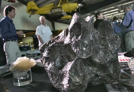
Meteorites sit on a display table at the Deep Space Industries announcement of plans for the world’s first fleet of commercial asteroid-prospecting spacecraft at the Museum of Flying in Santa Monica, California, January 22, 2013. Credit: Reuters/Jonathan Alcorn
(Reuters) – Mining in space is moving from science fiction to commercial reality but metals magnates on this planet need not fear a mountain of extraterrestrial supply – the aim is to fuel human voyages deeper into the galaxy.
Within three years, two firms plan prospecting missions to passing asteroids. When even a modest space rock might meet demand for metals like platinum or gold for centuries, it is little wonder storytellers have long fantasized that to harness cosmic riches could make, and break, fortunes on Earth.
But with no way to bring much ore or metal down from the heavens, new ventures that have backing from some serious – and seriously rich – business figures, as well as interest from NASA, will focus on using space minerals in interplanetary “gas stations” or to build, support and fuel colonies on Mars.
There may be gold up there, but the draw for now is water for investors willing to get the new industry off the ground.
Governments believe it has a future; NASA has a project that may put astronauts on an asteroid in under a decade and on Mars in the 2030s. And if the costs seem high, grumblers are told that one day the new skills might just save mankind from sharing the fate of the dinosaurs – if we can learn how to stop a massive asteroid smashing into Earth.
“We are dreamers,” declares the web site of Deep Space Industries (DSI), next to an image of a wheel-like metal station hooked up to a giant floating rock. But what the U.S.-based start-up firm calls the first small steps in a “long play” to develop the resources of space are about to happen.
A priority is using hydrogen and oxygen, the components of water locked in compounds on asteroids, to refuel rockets.
Early in 2016, the first of DSI’s exploration satellites, smaller than toasters, will hitch-hike into space on rockets carrying other payloads and start scouting for suitable rocks. The same year, another U.S.-based venture, Planetary Resources, expects to launch prospecting craft hunting viable asteroids.
“They are the low-hanging fruit of the solar system,” said Eric Anderson, an American aerospace engineer and co-founder of Planetary Resources, which lists Google’s Larry Page and Virgin billionaire Richard Branson among its backers.
“They are just there and they are not difficult to get to and they are not difficult to get away from,” he told Reuters.
METALS
Meteorites – chunks that survive and fall to earth after asteroids disintegrate in the atmosphere – yield significant amounts of precious metals like platinum, rhodium, iridium, rhenium, osmium, ruthenium, palladium, germanium and gold.
Planetary Resources estimates some platinum-rich asteroids just 500 meters across could contain more than the entire known reserves of platinum group metals. Studies based on observation and meteorites suggest space is even richer in iron ore.
Wall Street research firm Bernstein notes that a big asteroid called 16 Psyche, in the asteroid belt between Mars and Jupiter and measuring some 200 km (130 miles) across, may contain 17 million billion tones of nickel-iron – enough to satisfy mankind’s current demand for millions of years.
But costs and technical hurdles rule out hauling resources down to Earth in the foreseeable future, experts say. The real value in asteroid mining is for further space travel – and so hydrogen and oxygen reserves are as attractive as any metal.
“It’s ridiculous to believe that asteroid resources will ever compete with terrestrial alternatives and Earth markets,” said Brad Blair, a mining engineer and economist.
Referring to talk of city-sized settlements on Mars, he said: “The reason asteroid mining makes sense is because people might be some day where those resources are. You can’t put an 80,000-person colony on Mars without using the local ‘timber’.
“And if you’re going to use chemical propulsion, it’s going to take a lot of water to get them there.”
The energy released when hydrogen and oxygen combine to make water can power rockets. The presence of both elements in compounds found on asteroids offers scope to set up space factories to make fuel for missions to Mars and beyond as well as offering “pit stops” to extend the lives of satellites.
“We’re going to be looking at propellants for satellites, which is a multi-billion dollar industry to keep them alive,” said Rick Tumlinson, Deep Space Industries’ board chairman and a veteran promoter of commercial space development.
“We’ll eventually be an oasis, a place where you can get air, and we can provide propellants. So we’re a gas station,” Tumlinson told a recent seminar in London.
“You can take the process leftover material, the slag, and use it for shielding, or concrete, and build large structures, and of course there is a percentage of precious metals.”
CAMERAS, LASERS
DSI hopes to launch flying cameras it calls FireFlies early in 2016. Their images will let scientists judge the composition of asteroids they pass. They will use off-the-shelf parts in tried and tested modules, just 10 cm (4 inches) wide.
That first phase should cost some $20 million, DSI chief executive David Gump told Reuters, adding he expects about half to come from government and research institute contracts and half from corporate advertising and corporate sponsorship.
A year later, larger craft would begin two- to three-year missions to land and take samples for analysis. Most dramatic of all, the company sees a “harvester” craft heading out in 2019 to capture and divert the most promising asteroids so that they settle into orbit around Earth by 2021. On these, Gump said, DSI would try to make propellant and mine nickel and iron to make the building components for new structures in space.
“If we are successful producing resources in space then it makes what NASA wants to do, which is going to Mars, that much less expensive,” he said. “It costs a lot of money to launch everything from the ground.”
Planetary Resources plans to send telescopes into space to study asteroids between Earth and the moon. In a later phase, it will send out craft carrying deep-space lasers to gather data on some of the thousands of more distant asteroids.
“By 2020 we will have begun processing asteroidal material in space, and we will have our first interplanetary fuel stop,” Planetary Resources’ Anderson said. “A mission can leave the Earth and stop by the trading post and gas themselves up.”
And while commercial gain from asteroid exploration is drawing investors, the rest of humanity also has an interest.
A shift in climate caused by a big asteroid strike may have killed off the dinosaurs and NASA is taking the risk of another such impact seriously enough to go looking for similar threats.
As mining expert Blair put it: “For survival of the human species, we have to address the asteroids, or they will address us. Because statistically a big enough one will come along that will scrub the planet clean and set it back to zero.”
Note : The above story is based on materials provided by Susan Thomas for Reuters
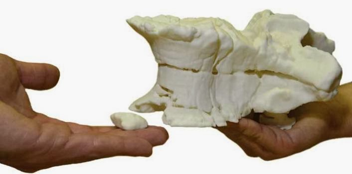
3-D print of vertebral body. (Credit: Image courtesy of Radiological Society of North America)
Data from computed tomography (CT) scans can be used with three-dimensional (3-D) printers to make accurate copies of fossilized bones, according to new research published online in the journal Radiology.
Fossils are often stored in plaster casts, or jackets, to protect them from damage. Getting information about a fossil typically requires the removal of the plaster and all the sediment surrounding it, which can lead to loss of material or even destruction of the fossil itself.
German researchers studied the feasibility of using CT and 3-D printers to nondestructively separate fossilized bone from its surrounding sediment matrix and produce a 3-D print of the fossilized bone itself.
“The most important benefit of this method is that it is non-destructive, and the risk of harming the fossil is minimal,” said study author Ahi Sema Issever, M.D., from the Department of Radiology at Charité Campus Mitte in Berlin. “Also, it is not as time-consuming as conventional preparation.”
Dr. Issever and colleagues applied the method to an unidentified fossil from the Museum für Naturkunde, a major natural history museum in Berlin. The fossil and others like it were buried under rubble in the basement of the museum after a World War II bombing raid. Since then, museum staff members have had difficulty sorting and identifying some of the plaster jackets.
Researchers performed CT on the unidentified fossil with a 320-slice multi-detector system. The different attenuation, or absorption of radiation, through the bone compared with the surrounding matrix enabled clear depiction of a fossilized vertebral body.
After studying the CT scan and comparing it to old excavation drawings, the researchers were able to trace the fossil’s origin to the Halberstadt excavation, a major dig from 1910 to 1927 in a clay pit south of Halberstadt, Germany. In addition, the CT study provided valuable information about the condition and integrity of the fossil, showing multiple fractures and destruction of the front rim of the vertebral body.
Furthermore, the CT dataset helped the researchers build an accurate reconstruction of the fossil with selective laser sintering, a technology that uses a high-powered laser to fuse together materials to make a 3-D object.
Dr. Issever noted that the findings come at a time when advances in technology and cheaper availability of 3-D printers are making them more common as a tool for research. Digital models of the objects can be transferred rapidly among researchers, and endless numbers of exact copies may be produced and distributed, greatly advancing scientific exchange, Dr. Issever said. The technology also potentially enables a global interchange of unique fossils with museums, schools and other settings.
“The digital dataset and, ultimately, reproductions of the 3-D print may easily be shared, and other research facilities could thus gain valuable informational access to rare fossils, which otherwise would have been restricted,” Dr. Issever said. “Just like Gutenberg’s printing press opened the world of books to the public, digital datasets and 3-D prints of fossils may now be distributed more broadly, while protecting the original intact fossil.”
Note : The above story is based on materials provided by Radiological Society of North America.
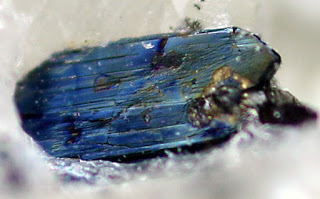
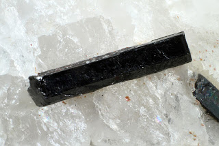
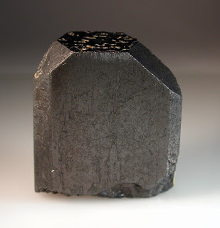
Chemical Formula: (Fe,Mn)(Nb,Ta)2O6 Locality: Globe and Harding pegmatites, Taos County, New Mexico, USA. Name Origin: Named for the MANGANese content and the relationship to columbite (ferrocolumbite).
Columbite, also called niobite, niobite-tantalite and columbate [(Fe, Mn)Nb2O6], is a black mineral group that is an ore of niobium. It has a submetallic luster and a high density and is a niobate of iron and manganese. This mineral group was first found in Haddam, Connecticut, in the United States. It forms a series with the tantalum-dominant analogue ferrotantalite and one with the manganese-dominant analogue manganocolumbite. The iron-rich member of the columbite group is ferrocolumbite. Some tin and tungsten may be present in the mineral. Yttrocolumbite is the yttrium-rich columbite with the formula (Y,U,Fe)(Nb,Ta)O4. It is a radioactive mineral found in Mozambique.
Columbite has the same composition and crystal symmetry (orthorhombic) as tantalite. In fact, the two are often grouped together as a semi-singular mineral series called columbite-tantalite or coltan in many mineral guides. However, tantalite has a much greater specific gravity than columbite, more than 8.0 compared to columbite’s 5.2.
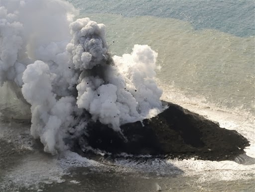
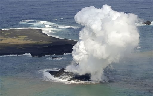
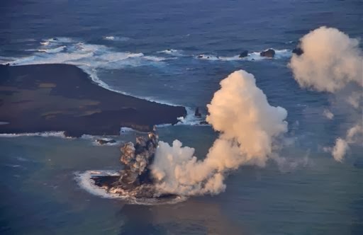
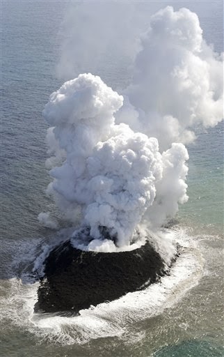
Smoke billows from a new island off the coast of Nishinoshima, a small, uninhabited island in the Ogasawara chain, far south of Tokyo Thursday, Nov. 21, 2013. The Japan Coast Guard and earthquake experts said a volcanic eruption has raised the new island in the seas to the far south of Tokyo. The coast guard issued an advisory Wednesday warning of heavy black smoke from the eruption. (AP Photo/Kyodo News) JAPAN OUT, MANDATORY CREDIT
A volcanic eruption has raised an island in the seas to the far south of Tokyo, the Japanese coast guard and earthquake experts said.
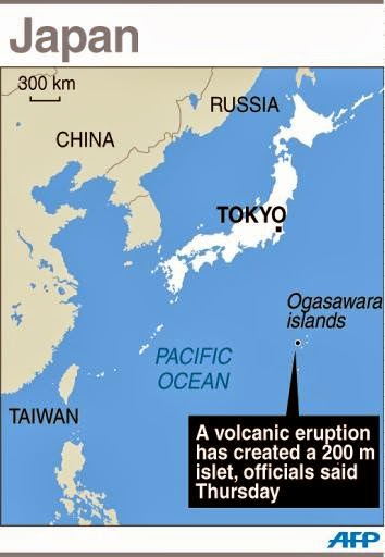
Advisories from the coast guard and the Japan Meteorological Agency said the islet is about 200 meters (660 feet) in diameter. It is just off the coast of Nishinoshima, a small, uninhabited island in the Ogasawara chain, which is also known as the Bonin Islands.
The approximately 30 islands are 1,000 kilometers (620 miles) south of Tokyo, and along with the rest of Japan are part of the seismically active Pacific “Ring of Fire.”
The coast guard issued an advisory Wednesday warning of heavy black smoke from the eruption. Television footage seen Thursday showed heavy smoke, ash and rocks exploding from the crater, as steam billowed into the sky.
A volcanologist with the coast guard, Hiroshi Ito, told the FNN news network that it was possible the new island might be eroded away.
“But it also could remain permanently,” he said.
The last time the volcanos in the area are known to have erupted was in the mid-1970s. Much of the volcanic activity occurs under the sea, which extends thousands of meters deep along the Izu-Ogasawara-Marianas Trench.
Smoke billows from a new island off the coast of Nishinoshima, seen left above, a small, uninhabited island in the Ogasawara chain, far south of Tokyo Thursday, Nov. 21, 2013. The Japan Coast Guard and earthquake experts said a volcanic eruption has raised the new island in the seas to the far south of Tokyo. The coast guard issued an advisory Wednesday warning of heavy black smoke from the eruption. (AP Photo/Kyodo News) JAPAN OUT, MANDATORY CREDIT
Japan’s chief government spokesman welcomed the news of yet another bit, however tiny, of new territory.”This has happened before and in some cases the islands disappeared,” Yoshihide Suga said when asked if the government was planning on naming the new island.
Graphic map showing the new islet created by a volcanic eruption in southern Japan
“If it becomes a full-fledged island, we would be happy to have more territory.”
Smoke billows from a new island off the coast of Nishinoshima, seen at bottom, a small, uninhabited island in the Ogasawara chain, far south of Tokyo Thursday, Nov. 21, 2013. The Japan Coast Guard and earthquake experts said a volcanic eruption has raised the new island in the seas to the far south of Tokyo. The coast guard issued an advisory Wednesday warning of heavy black smoke from the eruption. (AP Photo/Kyodo News) JAPAN OUT, MANDATORY CREDIT
The Japanese archipelago has thousands of islands. In some cases, they help anchor claims to wide expanses of ocean overlying potentially lucrative energy and mineral resources.
In this Wednesday, Nov. 20, 2013 photo released by Japan Coast Guard, smoke billows from a new island off the coast of Nishinoshima, seen left above, a small, uninhabited island in the Ogasawara chain, far south of Tokyo. The Japan Coast Guard and earthquake experts said a volcanic eruption has raised the new island in the seas to the far south of Tokyo. (AP Photo/Japan Coast Guard)
Japan has plans to build port facilities and transplant fast-growing coral fragments onto Okinotorishima, two rocky outcroppings even further south of Tokyo, to boost its claim in a territorial dispute with China.
Smoke billows from a new island off the coast of Nishinoshima, a small, uninhabited island in the Ogasawara chain, far south of Tokyo Thursday, Nov. 21, 2013. The Japan Coast Guard and earthquake experts said a volcanic eruption has raised the new island in the seas to the far south of Tokyo. The coast guard issued an advisory Wednesday warning of heavy black smoke from the eruption. (AP Photo/Kyodo News) JAPAN OUT, MANDATORY CREDIT
Note : The above story is based on materials provided by The Associated Press. All rights reserved.
AUSTIN, Texas — Researchers at The University of Texas at Austin have developed a simple scaling theory to estimate gas production from hydraulically fractured wells in the Barnett Shale. The method is intended to help the energy industry accurately identify low- and high-producing horizontal wells, as well as accurately predict how long it will take for gas reserves to deplete in the wells.
Using historical data from horizontal wells in the Barnett Shale formation in North Texas, Tad Patzek, professor and chair in the Department of Petroleum and Geosystems Engineering in the Cockrell School of Engineering; Michael Marder, professor of physics in the College of Natural Sciences; and Frank Male, a graduate student in physics, used a simple physics theory to model the rate at which production from the wells declines over time, known as the “decline curve.”
They describe their new model of the decline curve in the paper “Gas production in the Barnett Shale obeys a simple scaling theory,” published this week in the Proceedings of the National Academy of Sciences. To test their theory, the researchers analyzed 10 years of gas production data from the Barnett Shale licensed to the university by IHS CERA, a provider of global market and economic information.
The team’s estimates were an instrumental part of the comprehensive assessment of Barnett Shale reserves funded by the Alfred P. Sloan Foundation and issued earlier this year by the Bureau of Economic Geology at UT Austin.
Until now, estimates of shale gas production have primarily relied on models established for conventional oil and gas wells, which behave differently from the horizontal wells in gas-rich shales.
The researchers estimate the ultimate gas recovery from a sample of 8,294 horizontal wells in the Barnett Shale will be between 10 trillion and 20 trillion standard cubic feet (scf) during the lifetime of the wells. The study’s well sample is made up of about half of the 15,000 existing wells in the Barnett Shale, the geological formation outside Fort Worth that offers the longest production history for hydrofractured horizontal wells in the world.
“With our model at hand, you can better predict how much gas volume is left and how long it will take until that volume will be depleted,” Patzek said. “We are able to match historical production and predict future production of thousands of horizontal gas wells using this scaling theory.”
“The contributions of shale gas to the U.S. economy are so enormous that even small corrections to production estimates are of great practical significance,” Patzek said.
The researchers were surprised by how all of the wells they analyzed adhere to that simple scaling curve.
“By analyzing the basic physics underlying gas recovery from hydrofractured wells, we calculated a single curve that should describe how much gas comes out over time, and we showed that production from thousands of wells follows this curve,” Marder said.
Patzek adds: “We are able to predict when the decline will begin. Once decline sets in, gas production goes down rapidly.”
The decline of a well happens because of a process called pressure diffusion that causes pressure around a well to drop and gas production to decrease. The time at which gas pressure drops below its initial value everywhere in the rock between hydrofractures is called its interference time. On average, it takes five years for interference to occur, at which point wells produce gas at a far lower rate because the amount of gas coming out over time is proportional to the amount of gas remaining.
Using two parameters — a well’s interference time and the original gas in place — the researchers were able to determine the universal decline curve and extrapolate total gas production over time.
The researchers found that the scaling theory accurately predicted the behavior of approximately 2,000 wells in which production had begun to decrease exponentially within the past 10 years. The remaining wells were too young for the model to predict when decreases would set in, but the model enabled the researchers to estimate upper and lower production limits for well lifetime and the amount of gas that will be produced by the wells.
“For 2,057 of the horizontal wells in the Barnett Shale, interference is far enough advanced for us to verify that wells behave as predicted by the scaling form,” Patzek said. “The production forecasts will become more accurate as more production data becomes available.”
As a byproduct of their analysis, the researchers found that most horizontal wells for which predictions are possible underperform their theoretical production limits. The researchers have reached a tentative conclusion that many wells are on track to produce only about 10 percent of their potential.
The researchers conclude that well production could be greatly improved if the hydrofractures connected better to natural fractures in the surrounding rock. The process of hydraulic fracturing creates a network of cracks, like veins, in rocks that was previously impermeable, allowing gas to move. If there are high porosity and permeability within those connected cracks and hydrofractures, then a well is high producing. By contrast, if the connection with hydrofractures is weak, then a well is low producing.
“If this finding spurs research to understand why wells underperform, it may lead to improved production methods and eventually increase gas extraction from wells,” Marder said.
Work is underway on how to improve performance of hydrofractures in horizontal wells, Patzek added.
Note : The above story is based on materials provided by University of Texas at Austin
NASA’s Mars Reconnaissance Orbiter is providing new spectral “windows” into the diversity of Martian surface materials. Here in a volcanic caldera, bright magenta outcrops have a distinctive feldspar-rich composition. (Credit: NASA/JPL/JHUAPL/MSSS)
Researchers now have stronger evidence of granite on Mars and a new theory for how the granite — an igneous rock common on Earth — could have formed there, according to a new study. The findings suggest a much more geologically complex Mars than previously believed.
Large amounts of a mineral found in granite, known as feldspar, were found in an ancient Martian volcano. Further, minerals that are common in basalts that are rich in iron and magnesium, ubiquitous on Mars, are nearly completely absent at this location. The location of the feldspar also provides an explanation for how granite could have formed on Mars.
Granite, or its eruptive equivalent, rhyolite, is often found on Earth in tectonically active regions such as subduction zones. This is unlikely on Mars, but the research team concluded that prolonged magmatic activity on Mars can also produce these compositions on large scales.
“We’re providing the most compelling evidence to date that Mars has granitic rocks,” said James Wray, an assistant professor in the School of Earth and Atmospheric Sciences at the Georgia Institute of Technology and the study’s lead author.
The research was published November 17 in the Advance Online Publication of the journal Nature Geoscience. The work was supported by the NASA Mars Data Analysis Program.
For years Mars was considered geologically simplistic, consisting mostly of one kind of rock, in contrast to the diverse geology of Earth. The rocks that cover most of Mars’s surface are dark-colored volcanic rocks, called basalt, a type of rock also found throughout Hawaii for instance.
But earlier this year, the Mars Curiosity rover surprised scientists by discovering soils with a composition similar to granite, a light-colored, common igneous rock. No one knew what to make of the discovery because it was limited to one site on Mars.
The new study bolsters the evidence for granite on Mars by using remote sensing techniques with infrared spectroscopy to survey a large volcano on Mars that was active for billions of years. The volcano is dust-free, making it ideal for the study. Most volcanoes on Mars are blanketed with dust, but this volcano is being sand-blasted by some of the fastest-moving sand dunes on Mars, sweeping away any dust that might fall on the volcano. Inside, the research team found rich deposits of feldspar, which came as a surprise.
“Using the kind of infrared spectroscopic technique we were using, you shouldn’t really be able to detect feldspar minerals, unless there’s really, really a lot of feldspar and very little of the dark minerals that you get in basalt,” Wray said.
The location of the feldspar and absence of dark minerals inside the ancient volcano provides an explanation for how granite could form on Mars. While the magma slowly cools in the subsurface, low density melt separates from dense crystals in a process called fractionation. The cycle is repeated over and over for millennia until granite is formed. This process could happen inside of a volcano that is active over a long period of time, according to the computer simulations run in collaboration with Josef Dufek, who is also an associate professor in the School of Earth and Atmospheric Sciences at Georgia Tech.
“We think some of the volcanoes on Mars were sporadically active for billions of years,” Wray said. “It seems plausible that in a volcano you could get enough iterations of that reprocessing that you could form something like granite.”
This process is sometimes referred to as igneous distillation. In this case the distillation progressively enriches the melt in silica, which makes the melt, and eventual rock, lower density and gives it the physical properties of granite.
“These compositions are roughly similar to those comprising the plutons at Yosemite or erupting magmas at Mount St. Helens, and are dramatically different than the basalts that dominate the rest of the planet,” Dufek said.
Another study published in the same edition of Nature Geoscience by a different research team offers another interpretation for the feldspar-rich signature on Mars. That team, from the European Southern Observatory and the University of Paris, found a similar signature elsewhere on Mars, but likens the rocks to anorthosite, which is common on the moon. Wray believes the context of the feldspar minerals inside of the volcano makes a stronger argument for granite. Mars hasn’t been known to contain much of either anorthosite or granite, so either way, the findings suggest the Red Planet is more geologically interesting than before.
“We talk about water on Mars all the time, but the history of volcanism on Mars is another thing that we’d like to try to understand,” Wray said. “What kinds of rocks have been forming over the planet’s history? We thought that it was a pretty easy answer, but we’re now joining the emerging chorus saying things may be a little bit more diverse on Mars, as they are on Earth.”
This research is supported by the NASA Mars Data Analysis Program under award NNX13AH80G. Any conclusions or opinions are those of the authors and do not necessarily represent the official views of the sponsoring agencies.
Note : The above story is based on materials provided by Georgia Institute of Technology. The original article was written by Brett
The team analyzed amber samples from almost all well-known amber deposits worldwide. This amber originates from the Cretaceous period, an inclusion of foliage of the extinct conifer tree Parataxodium sp. from the Foremost Formation at Grassy Lake, Alberta, Canada. It is approximately 77 million years old. (Credit: Ryan C. McKellar)
An international team of researchers led by Ralf Tappert, University of Innsbruck, reconstructed the composition of Earth’s atmosphere of the last 220 million years by analyzing modern and fossil plant resins. The results suggest that atmospheric oxygen was considerably lower in Earth’s geological past than previously assumed. This new study questions some of the current theories about the evolution of climate and life, including the causes for the gigantism of dinosaurs.
Scientists encounter big challenges when reconstructing atmospheric compositions in Earth’s geological past because of the lack of useable sample material. One of the few organic materials that may preserve reliable data of Earth’s geological history over millions of years are fossil resins (e.g. amber). “Compared to other organic matter, amber has the advantage that it remains chemically and isotopically almost unchanged over long periods of geological time,” explains Ralf Tappert from the Institute of Mineralogy and Petrography at the University of Innsbruck. The mineralogist and his colleagues from the University of Alberta in Canada and universities in the USA and Spain have produced a comprehensive study of the chemical composition of Earth’s atmosphere since the Triassic period.
The study has been published in the journal Geochimica et Cosmochimica Acta. The interdisciplinary team, consisting of mineralogists, paleontologists and geochemists, use the preserving properties of plant resins, caused by polymerization, for their study. “During photosynthesis plants bind atmospheric carbon, whose isotopic composition is preserved in resins over millions of years, and from this, we can infer atmospheric oxygen concentrations,” explains Ralf Tappert. The information about oxygen concentration comes from the isotopic composition of carbon or rather from the ratio between the stable carbon isotopes 12C and 13C.
Atmospheric oxygen between 10 and 15 percent
The research team analyzed a total of 538 amber samples from from well-known amber deposits worldwide, with the oldest samples being approximately 220 million years old and recovered from the Dolomites in Italy. The team also compared fossil amber with modern resins to test the validity of the data. The results of this comprehensive study suggest that atmospheric oxygen during most of the past 220 million years was considerably lower than today’s 21 percent. “We suggest numbers between 10 and 15 percent,” says Tappert. These oxygen concentrations are not only lower than today but also considerably lower than the majority of previous investigations propose for the same time period. For the Cretaceous period (65 — 145 million years ago), for example, up to 30 percent atmospheric oxygen has been suggested previously.
Effects on climate and environment
The researchers also relate this low atmospheric oxygen to climatic developments in Earth’s history. “We found that particularly low oxygen levels coincided with intervals of elevated global temperatures and high carbon dioxide concentrations,” explains Tappert. The mineralogist suggests that oxygen may influence carbon dioxide levels and, under certain circumstances, might even accelerate the influx of carbon dioxide into the atmosphere. “Basically, we are dealing here with simple oxidation reactions that are amplified particularly during intervals of high temperatures such as during the Cretaceous period.” The researchers, thus, conclude that an increase in carbon dioxide levels caused by extremely strong vulcanism was accompanied by a decrease of atmospheric oxygen. This becomes particularly apparent when looking at the last 50 million years of geological history. Following the results of this study, the comparably low temperatures of the more recent past (i.e. the Ice Ages) may be attributed to the absence of large scale vulcanism events and an increase in atmospheric oxygen.
Oxygen may not be the cause of gigantism
According to the results of the study, oxygen may indirectly influence the climate. This in turn may also affect the evolution of life on Earth. A well-known example are dinosaurs: Many theories about animal gigantism offer high levels of atmospheric oxygen as an explanation. Tappert now suggests to reconsider these theories: “We do not want to negate the influence of oxygen for the evolution of life in general with our study, but the gigantism of dinosaurs cannot be explained by those theories.” The research team highly recommends conducting further studies and intends to analyze even older plant resins.
Note : The above story is based on materials provided by University of Innsbruck.
Mount Sidley, at the leading edge of the Executive Committee Range in Marie Byrd Land, is the last volcano in the chain that rises above the surface of the ice. But a group of seismologists has detected new volcanic activity under the ice about 30 miles ahead of Mount Sidley in the direction of the range’s migration. The new finding suggests that the source of magma is moving beyond the chain beneath the crust and the Antarctic Ice Sheet. (Credit: Doug Wiens)
It wasn’t what they were looking for but that only made the discovery all the more exciting.
In January 2010 a team of scientists had set up two crossing lines of seismographs across Marie Byrd Land in West Antarctica. It was the first time the scientists had deployed many instruments in the interior of the continent that could operate year-round even in the coldest parts of Antarctica.
Like a giant CT machine, the seismograph array used disturbances created by distant earthquakes to make images of the ice and rock deep within West Antarctica.
There were big questions to be asked and answered. The goal, says Doug Wiens, professor of earth and planetary science at Washington University in St. Louis and one of the project’s principle investigators, was essentially to weigh the ice sheet to help reconstruct Antarctica’s climate history. But to do this accurately the scientists had to know how Earth’s mantle would respond to an ice burden, and that depended on whether it was hot and fluid or cool and viscous. The seismic data would allow them to map the mantle’s properties.
In the meantime, automated-event-detection software was put to work to comb the data for anything unusual.
When it found two bursts of seismic events between January 2010 and March 2011, Wiens’ PhD student Amanda Lough looked more closely to see what was rattling the continent’s bones.
Was it rock grinding on rock, ice groaning over ice, or, perhaps, hot gases and liquid rock forcing their way through cracks in a volcanic complex?
Uncertain at first, the more Lough and her colleagues looked, the more convinced they became that a new volcano was forming a kilometer beneath the ice.
The discovery of the new as yet unnamed volcano is announced in the Nov. 17 advanced online issue of Nature Geoscience.
Following the trail of clues
The teams that install seismographs in Antarctica are given first crack at the data. Lough had done her bit as part of the WUSTL team, traveling to East Antarctica three times to install or remove stations in East Antarctica.
In 2010 many of the instruments were moved to West Antarctica and Wiens asked Lough to look at the seismic data coming in, the first large-scale dataset from this part of the continent.
“I started seeing events that kept occurring at the same location, which was odd, “Lough said. “Then I realized they were close to some mountains-but not right on top of them.”
“My first thought was, ‘Okay, maybe its just coincidence.’ But then I looked more closely and realized that the mountains were actually volcanoes and there was an age progression to the range. The volcanoes closest to the seismic events were the youngest ones.”
The events were weak and very low frequency, which strongly suggested they weren’t tectonic in origin. While low-magnitude seismic events of tectonic origin typically have frequencies of 10 to 20 cycles per second, this shaking was dominated by frequencies of 2 to 4 cycles per second.
Ruling out ice
But glacial processes can generate low-frequency events. If the events weren’t tectonic could they be glacial?
To probe farther, Lough used a global computer model of seismic velocities to “relocate” the hypocenters of the events to account for the known seismic velocities along different paths through the Earth. This procedure collapsed the swarm clusters to a third their original size.
It also showed that almost all of the events had occurred at depths of 25 to 40 kilometers (15 to 25 miles below the surface). This is extraordinarily deep — deep enough to be near the boundary between the earth’s crust and mantle, called the Moho, and more or less rules out a glacial origin.
It also casts doubt on a tectonic one. “A tectonic event might have a hypocenter 10 to 15 kilometers (6 to 9 miles) deep, but at 25 to 40 kilometers, these were way too deep,” Lough says.
A colleague suggested that the event waveforms looked like Deep Long Period earthquakes, or DPLs, which occur in volcanic areas, have the same frequency characteristics and are as deep. “Everything matches up,” Lough says.
An ash layer encased in ice
The seismologists also talked to Duncan Young and Don Blankenship of the University of Texas who fly airborne radar over Antarctica to produce topographic maps of the bedrock. “In these maps, you can see that there’s elevation in the bed topography at the same location as the seismic events,” Lough says.
The radar images also showed a layer of ash buried under the ice. “They see this layer all around our group of earthquakes and only in this area,” Lough says.
“Their best guess is that it came from Mount Waesche, an existing volcano near Mt Sidley. But that is also interesting because scientists had no idea when Mount Waesche was last active, and the ash layer is sets the age of the eruption at 8,000 years ago. ”
What’s up down there?
The case for volcanic origin has been made. But what exactly is causing the seismic activity?
“Most mountains in Antarctica are not volcanic,” Wiens says, “but most in this area are. Is it because East and West Antarctica are slowly rifting apart? We don’t know exactly. But we think there is probably a hot spot in the mantle here producing magma far beneath the surface.”
“People aren’t really sure what causes DPLs,” Lough says. “It seems to vary by volcanic complex, but most people think it’s the movement of magma and other fluids that leads to pressure-induced vibrations in cracks within volcanic and hydrothermal systems.”
Will the new volcano erupt?
“Definitely,” Lough says. “In fact because of the radar shows a mountain beneath the ice I think it has erupted in the past, before the rumblings we recorded.
Will the eruptions punch through a kilometer or more of ice above it?
The scientists calculated that an enormous eruption, one that released a thousand times more energy than the typical eruption, would be necessary to breach the ice above the volcano.
On the other hand a subglacial eruption and the accompanying heat flow will melt a lot of ice. “The volcano will create millions of gallons of water beneath the ice — many lakes full,” says Wiens. This water will rush beneath the ice towards the sea and feed into the hydrological catchment of the MacAyeal Ice Stream, one of several major ice streams draining ice from Marie Byrd Land into the Ross Ice Shelf.
By lubricating the bedrock, it will speed the flow of the overlying ice, perhaps increasing the rate of ice-mass loss in West Antarctica.
“We weren’t expecting to find anything like this,” Wiens says.
Note : The above story is based on materials provided by Washington University in St. Louis. The original article was written by Diana Lutz.
The remote site where scientists have discovered fossilised bacteria. Researchers say they have fresh evidence of the oldest life on Earth, with fossilised bacteria dating more than 3.5bn years. Photograph: David Wacey/AAP
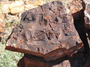
Evidence of what could be the earliest forms of life on Earth has been unearthed in the remote Pilbara region of Western Australia.
Researchers from Australia and the US have discovered signs of “complex microbial ecosystems” within rock sediments dated at 3.5bn years old.
The microbes were found in a body of rock called the Dresser Formation, west of Marble Bar in WA.
Professor David Wacey, researcher at the University of Western Australia, told Guardian Australia the discovery “pushes back evidence of life on Earth by a few more million years”.
“The Pilbara has some of the best, least deformed rocks on Earth; there aren’t many rocks older than there,” he said. “I would say this is the most robust evidence of the oldest life on Earth. My team has found evidence dated at 3.45bn years in the past, so we have gone further back by a few million years.”
Wacey said slivers of rock were analysed by the team, which found evidence of groups of microbes within the sediment.
“Microbes and bacteria like to live in communities. Think about the bacteria in your stomach, for example,” he said. “These microbes lived in layers that required different chemical gradients to survive. So bacteria that liked light would be towards the top while those that didn’t were towards the bottom.”
Earth was a far different place 3.5bn years ago, with temperatures and sea levels much higher than today. Bacterial communities, such as that found in the Pilbara, were the most advanced form of life for several billion years before more complex life forms began to develop.
“Bacteria ruled the world back then, it would’ve been a very smelly world indeed,” said Wacey. “It would’ve been pretty hostile for us. There was essentially no oxygen, a lot of CO2 and methane and much warmer oceans.
“Most of the world was covered by water, with just a bit of land sticking out here and there. There was a lot of volcanic activity and plenty of sulphur in the air. Until 2.5bn years ago, there was only the start of the evolution that would see cells with nucleoli, then evolving to multi-cell organisms such as animals and us.”
Wacey said that the search for slightly older organisms would go on, potentially in ancient rock formations in South Africa and Greenland, but the Pilbara discovery could have further ramifications in the quest to learn more about the solar system.
“These kinds of ecosystems could be viewed by a rover, such as the one that visited Mars,” Wacey said. “We wouldn’t know the age, of course, as we couldn’t date them. But we would know that there was life at some point on another planet, which would be pretty exciting.”
Note : The above story is based on materials provided by Oliver Milman for the guardian
The researchers used the endocast of a Tyrannosaurus rex (pictured), an Allosaurus and the early bird Archaeopteryx. Photograph: Jim Zuckerman/Corbis
Scientists have created a detailed map of the dinosaur brain for the first time and found that the ancient beasts had the faculties for complex behaviour, and perhaps made sounds to communicate with one another.
The map provides an unprecedented view of the makeup of the dinosaur brain and a glimpse back in time at what the creatures might have been capable of during their reign on Earth millions of years ago.
“In the popular mind, dinosaurs may be underrated in the complexity of their behaviour,” said Erich Jarvis, who led the study at Duke University in North Carolina.
Soft tissues are not preserved in fossils, so researchers have had to infer the details of dinosaur brains from the faint impressions the organs leave on the insides of fossilised skulls. These “endocasts” give a sense of the size and shape of the outermost brain parts, but leave no clues about the brain’s deeper structures.
But now researchers have pieced together the innermost regions of the dinosaur brain, including six areas that are specialised for complex behaviour such as processing visual information and learning and making sounds.
Among other skills, the extinct beasts had sufficient brain complexity to communicate with sounds, Jarvis said. “But did it really happen? That we do not know.”
To recreate the dinosaur brain, the US researchers first studied the brains of alligators and birds. Alligators came from a lineage that predated many dinosaurs, while the first birds evolved afterwards. On that basis, Jarvis and his colleague Chun-Chun Chen argue that the dinosaur brain should have evolved to be somewhere in between.
The researchers drew up detailed maps of alligator and bird brains using a recently developed procedure that relies on gene activity varying across different parts of the brain. Though some genes are switched on in the brain all the time, others are activated only momentarily when something happens. This is the case for auditory regions of the brain, where genes are switched on in response to sounds.
To map the auditory regions of the brain, Jarvis quietened the animals down in a darkened room and then played bird songs to birds and alligator grunts to alligators. He then swiftly removed their brains, froze them, sliced them, and looked at the genes that had switched on in different regions.
The genetic information allowed Jarvis to make high-precision maps of bird and alligator brains, which showed the various regions and their organisation. To get the structure of the dinosaur brain he simply merged the two, and shaped the map to dinosaur brain proportions, which Chen worked out from the endocasts from Tyrannosaurus rex, an Allosaurus and the early bird Archaeopteryx.
The map of the dinosaur brain contained six regions, including one called the mesopallium involved in complex processing. “It suggests that the dinosaur brain had the capacity for complex sensory motor processing, just like we see in birds and alligators,” said Jarvis.
But while song birds learn tunes and sing them, Jarvis said, it was impossible to know whether dinosaurs were capable of a similar form of “vocal learning”.
“We don’t have any evidence that there was a dinosaur out there that did this, that shared vocal learning with songbirds. But all the brain subdivisions to support vocal learning are there, so I’d argue the capacity to evolve vocal learning did exist in dinosaurs,” he said. Jarvis described the study at the Society for Neuroscience meeting in San Diego.
“Because birds and alligators have this large cortex, it suggests that dinosaurs probably had a pretty big cortex too and were capable of pretty sophisticated behaviours,” said Michale Fee, who studies bird brains at MIT.
“It’s very unlikely that we’re ever going to find a dinosaur brain preserved anywhere, so the details are always going to have to be inferred. As we understand brain evolution better we’ll be able to make sharper speculations about what dinosaur brains might have looked like. But actually nailing it with real data is going to be hard,” he said.
Note : The above story is based on materials provided by Ian Sample, science correspondent, in San Diego for the guardian
The location of gold and nickel deposits on the WIS rings indicate its significance to the makeup of the Eastern Goldfields. Credit: Allan Rostron
The world’s largest and oldest meteorite impact structure has been discovered through research on the formation of gold deposits in WA’s Eastern Goldfields.
Located in the eastern Yilgarn, the Watchorn Impact Structure (WIS) is 560km in diameter at its widest point and estimated to be more than 2.6 billion years old.
Geologist Bob Watchorn says he has been analysing the structure using gravity and seismic databases since 1999 but has only recently discovered the prima facie evidence necessary to confirm its impact origin.
“I pinpointed where the rings should cut the roads … [and] you can see lines of hills heading perpendicular to the trend of hills in the eastern Yilgarn which is usually north-south,” he says.
“On the northern rings especially you can see large in situ shatter cones and striated rocks and various other prima facie evidence of a big impact.
“It was satisfying to find the prima facie evidence on the interpreted Landsat rings when I have had so many eminent geologists and geophysicists say that they couldn’t see any circular features.”
He says the link between mineral deposits and the rings of the WIS could impact mineral exploration in WA.
“I plotted all the gold and nickel mines [in the Eastern Goldfields] onto the Western Mining database,” he says.
“All of the big gold mines—I mean every single mine that was over one million ounces fell on the rings.
“If you’re going to go looking for deposits you should be looking in an entirely different location than what you would have before.”
He says careful analysis of the Yilgarn regional gravity data using small incremental changes to the sun angle dip and azimuth facilitated the discovery of the structure.
“I got the geophysicists to treat the databases in a very different way than what they normally treated it,” he says.
“I could see many concentric circular structures… at different levels of the lithosphere and then check them against seismic traverses that had been done.
“Eventually I was able to correlate different depth plans of the gravity data with the seismic data and noticed concentric bowl and dome shaped structures which correlated to the impact structures.”
He says the location of gold and nickel deposits on the rings are indicative of its significance to the makeup of the Eastern Goldfields.
“I know the gold deposits are 2.6 to 2.64 billion years old and they’ve actually formed on the rings,” he says.
“However the nickel formed 2.67 to 2.72 billion years ago and as most of the big nickel mines are on the rings there are still unanswered questions.
“It’s a paradigm-shifting discovery.”
Notes:
The Vredefort Crater, in South Africa, was previously thought to be the largest known impact structure at 300km in diameter and just over 2 billion years old
Shatter cones are rare geological structures known only to form beneath meteorite impact craters—they are evidence the rock has been subjected to significant pressure
Lithosphere—refers to the earth’s crust and upper mantle
Note : The above story is based on materials provided by Science Network WA
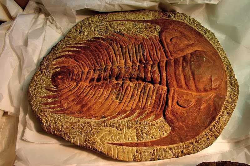
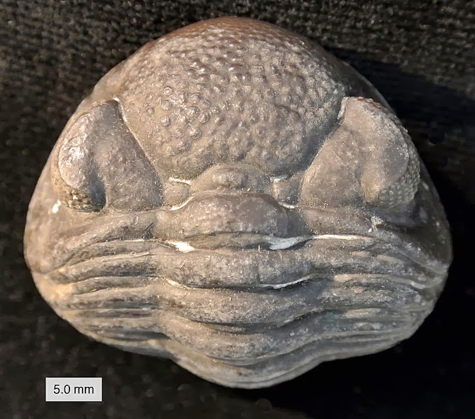
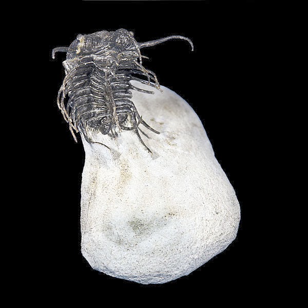
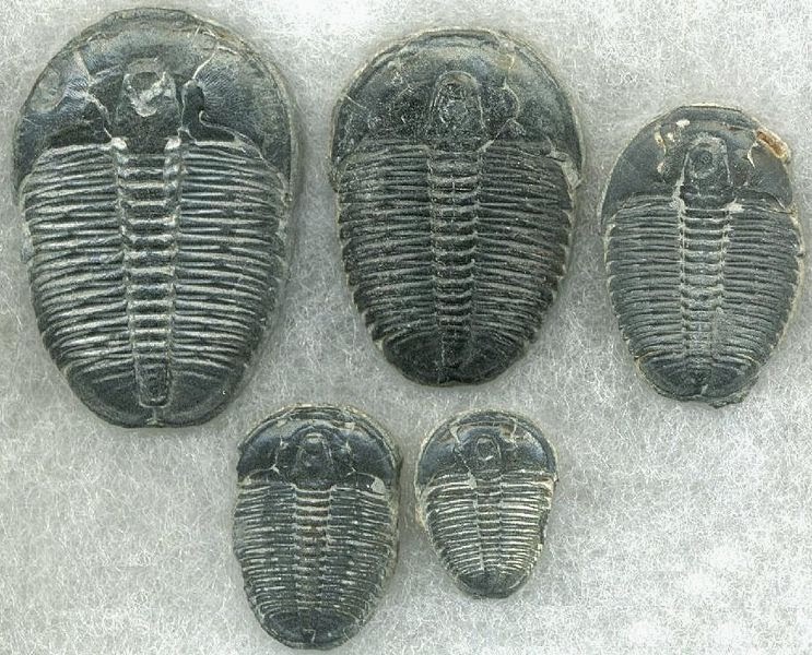
Paradoxides subgenus Eccaparadoxides sp., Order Redlichiida, Family Paradoxididae, 163mm, from Morocco, Middle Cambrian Credit: Wikipedia
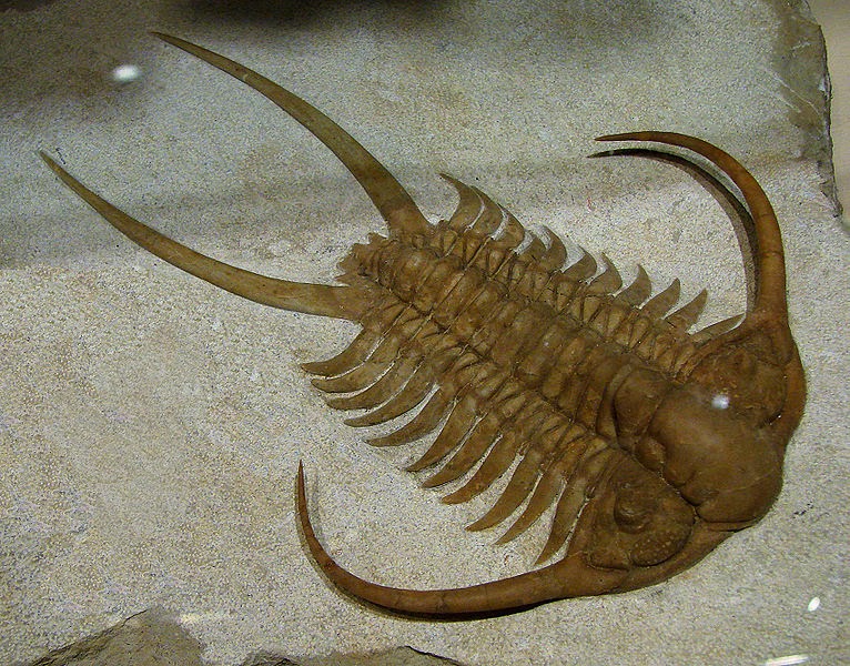
Trilobites are a well-known fossil group of extinct marine arthropods that form the class Trilobita. Trilobites form one of the earliest known groups of arthropods. The first appearance of trilobites in the fossil record defines the base of the Atdabanian stage of the Early Cambrian period (521 million years ago), and they flourished throughout the lower Paleozoic era before beginning a drawn-out decline to extinction when, during the Devonian, all trilobite orders except Proetida died out. Trilobites finally disappeared in the mass extinction at the end of the Permian about 250 million years ago. The trilobites were among the most successful of all early animals, roaming the oceans for over 270 million years.
When trilobites first appeared in the fossil record they were already highly diverse and geographically dispersed. Because trilobites had wide diversity and an easily fossilized exoskeleton an extensive fossil record was left behind, with some 17,000 known species spanning Paleozoic time. The study of these fossils has facilitated important contributions to biostratigraphy, paleontology, evolutionary biology and plate tectonics. Trilobites are often placed within the arthropod subphylum Schizoramia within the superclass Arachnomorpha (equivalent to the Arachnata), although several alternative taxonomies are found in the literature.
Trilobites had many life styles; some moved over the sea-bed as predators, scavengers or filter feeders and some swam, feeding on plankton. Most life styles expected of modern marine arthropods are seen in trilobites, with the possible exception of parasitism (where there are still scientific debates). Some trilobites (particularly the family Olenidae) are even thought to have evolved a symbiotic relationship with sulfur-eating bacteria from which they derived food.
Fossil record
The earliest trilobites known from the fossil record are fallotaspids, and redlichiids (both order Redlichiida)
Redlichida, such as this Paradoxides, may represent the ancestral trilobites
.and bigotinids (order Ptychopariida, superfamily Ellipsocephaloidea) dated to some 540 to 520 million years ago. Contenders for the earliest trilobites include Profallotaspis jakutensis (Siberia), Fritzaspis spp. (western USA), Hupetina antiqua (Morocco) and Serrania gordaensis (Spain). All trilobites are thought to have originated in present day Siberia, with subsequent distribution and radiation from this location.
All Olenellina lack facial sutures (see below), and this is thought to represent the original state. The earliest sutured trilobite found so far (Lemdadella), occurs almost at the same time as the earliest Olenellina however, implying that trilobite origin lies before the start of the Atdabanian, but without leaving fossils. Other groups show secondary lost facial sutures, such as all Agnostina and some Phacopina. Another common feature of the Olenellina also suggests this suborder to be the ancestral trilobite stock: early protaspid stages have not been found, supposedly because these were not calcified, and this also is supposed to represent the original state. Earlier trilobites may be found and could shed more light on the origin of trilobites.
Origins
Early trilobites show all the features of the trilobite group as a whole; there do not seem to be any transitional or ancestral forms showing or combining the features of trilobites with other groups (e.g. early arthropods).
Morphological similarities between trilobites and early arthropod-like creatures such as Spriggina, Parvancorina, and other “trilobitomorphs” of the Ediacaran period of the Precambrian are ambiguous enough to make detailed analysis of their ancestry far from compelling. Morphological similarities between early trilobites and other Cambrian arthropods (e.g. the Burgess Shale fauna and the Maotianshan shales fauna) make analysis of ancestral relationships difficult.
However, it is still reasonable to assume that the trilobites share a common ancestor with other arthropods before the Ediacaran-Cambrian boundary. Evidence suggests that significant diversification had already occurred before trilobites were preserved in the fossil record, easily allowing for the “sudden” appearance of diverse trilobite groups with complex derived characteristics (e.g. eyes).
Divergence and extinction
For such a long-lasting group of animals, it is no surprise that trilobite evolutionary history is marked by a number of extinction events where some groups perished while surviving groups diversified to fill ecological niches with comparable or novel adaptations. Generally, trilobites maintained high diversity levels throughout the Cambrian and Ordovician periods before entering a drawn-out decline in the Devonian culminating in final extinction of the last few survivors at the end of the Permian period.
Evolutionary trends
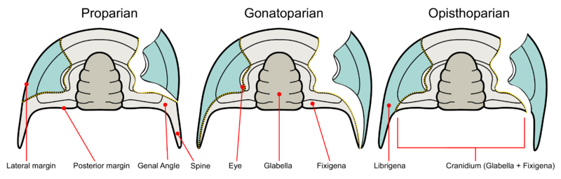
Principal evolutionary trends from primitive morphologies (e.g. eoredlichids) include the origin of new types of eyes, improvement of enrollment and articulation mechanisms, increased size of pygidium (micropygy to isopygy) and development of extreme spinosity in certain groups. Changes also included narrowing of the thorax and increasing or decreasing numbers of thoracic segments. Specific changes to the cephalon are also noted; variable glabella size and shape, position of eyes and facial sutures & hypostome specialization. Several morphologies appeared independently within different major taxa (e.g. eye reduction or miniaturization).
Effacement is also a common evolutionary trend. It is the loss of surface detail in the cephalon, pygidium, or the thoracic furrows. Notable examples of this were the orders Agnostida, Asaphida, and the suborder Illaenina of Corynexochida. It is believed that effacement is an indication of either a burrowing lifestyle or a pelagic one. Effacement poses a problem for taxonomists since the loss of details (particularly of the Glabella) can make the determination of phylogenetic relationships difficult.
Pre-Cambrian
Phylogenetic biogeographic analysis of Early Cambrian Olenellidae and Redlichidae suggests that a uniform trilobite fauna existed over Laurentia, Gondwana and Siberia before the tectonic breakup of the super-continent Pannotia between 600 million years ago and 550 million years ago.Tectonic breakup of Pannotia then allowed for the diversification and radiation expressed later in the Cambrian as the distinctive olenellid province (Laurentia, Siberia and Baltica) and the separate Redlichid province (Australia, Antarctica and China). Breakup of Pannotia significantly predates the first appearance of trilobites in the fossil record, supporting a long and cryptic development of trilobites extending perhaps as far back as 700 million years ago or possibly further.
Cambrian
Very shortly after trilobite fossils appeared in the lower Cambrian, they rapidly diversified into the major orders that typified the Cambrian—Redlichiida, Ptychopariida, Agnostida and Corynexochida. The first major crisis in the trilobite fossil record occurred in the Middle Cambrian; surviving orders developed isopygus or macropygius bodies and developed thicker cuticles, allowing better defense against predators (see Thorax above). The end Cambrian mass extinction event marked a major change in trilobite fauna; almost all Redlichiida (including the Olenelloidea) and most Late Cambrian stocks went extinct. A continuing decrease in Laurentian continental shelf area is recorded at the same time as the extinctions, suggesting major environmental upheaval.
Ordovician
The Early Ordovician is marked by vigorous radiations of articulate brachiopods, bryozoans, bivalves,
Cheirurus sp., middle Ordovician age, Volkhov River, Russia
echinoderms, and graptolites with many groups appearing in the fossil record for the first time. Although intra-species trilobite diversity seems to have peaked during the Cambrian, trilobites were still active participants in the Ordovician radiation event with a new fauna taking over from the old Cambrian one.
Phacopida and Trinucleioidea are characteristic forms, highly differentiated and diverse, most with uncertain ancestors. The Phacopida and other “new” clades almost certainly had Cambrian forebears, but the fact that they have avoided detection is a strong indication that novel morphologies were developing very rapidly.
Changes within the trilobite fauna during the Ordovician foreshadowed the mass extinction at the end of the Ordovician allowing many families to continue into the Silurian with little disturbance. Ordovician trilobites were successful at exploiting new environments, notably reefs. However, the end Ordovician mass extinction did not leave the trilobites unscathed; some distinctive and previously successful forms such as the Trinucleioidea and Agnostida became extinct.
The Ordovician marks the last great diversification period amongst the trilobites, very few entirely new patterns of organisation arose post-Ordovician; later evolution in trilobites was largely a matter of variations upon the Ordovician themes. By the Ordovician mass extinction vigorous trilobite radiation has stopped and gradual decline beckons.
Silurian and Devonian
Phacopid trilobite, Devonian age , Ohio, United States
Most Early Silurian families constitute a subgroup of the Late Ordovocian fauna. Few, if any, of the dominant Early Ordovician fauna survived to the end of the Ordovician, yet 74% of the dominant Late Ordovician trilobite fauna survived the Ordovician. Late Ordovician survivors account for all post-Ordovician trilobite groups except the Harpetida.
Silurian and Devonian trilobite assemblages are superficially similar to Ordovician assemblages, dominated by Lichida and Phacopida (including the well-known Calymenina). However, a number of characteristic forms do not extend far into the Devonian and almost all the remainder were wiped out by a series of drastic Middle and Late Devonian extinctions. Three orders and all but five families were exterminated by the combination of sea level changes and a break in the redox equilibrium (a meteorite impact has also been suggested as a cause). Only a single order, the Proetida, survived into the Carboniferous.
Carboniferous and Permian
The Proetida survived for millions of years, continued through the Carboniferous period and lasted until the end of the Permian (when the vast majority of species on Earth were wiped out). It is unknown why order Proetida alone survived the Devonian. The Proetida maintained relatively diverse faunas in deep water and shallow water, shelf environments throughout the Carboniferous. For many millions of years the Proetida existed untroubled in their ecological niche. An analogy would be today’s crinoids, which mostly exist as deep water species; in the Paleozoic era, vast ‘forests’ of crinoids lived in shallow near-shore environments.
Final extinction
Exactly why the trilobites became extinct is not clear; with repeated extinction events (often followed by apparent recovery) throughout the trilobite fossil record, a combination of causes is likely. After the extinction event at the end of the Devonian period, what trilobite diversity remained was bottlenecked into the order Proetida. Decreasing diversity of genera limited to shallow water, shelf habitats coupled with a drastic lowering of sea level (regression) meant that the final decline of trilobites happened shortly before the end of the Permian mass extinction event. With so many marine species involved in the Permian extinction, the end of nearly 300 million successful years for the trilobite is hardly surprising.
The closest extant relatives of trilobites may be the horseshoe crabs, or the cephalocarids.
Fossil distribution
A trilobite fragment (T) in a thin-section of an Ordovician limestone; E=echinoderm; scale bar is 2 mm
Trilobites appear to have been exclusively marine organisms, since the fossilized remains of trilobites are always found in rocks containing fossils of other salt-water animals such as brachiopods, crinoids, and corals. Within the marine paleoenvironment, trilobites were found in a broad range from extremely shallow water to very deep water. Trilobites, like brachiopods, crinoids, and corals, are found on all modern continents, and occupied every ancient ocean from which Paleozoic fossils have been collected. The remnants of trilobites can range from the preserved body to pieces of the exoskeleton, which it sheds in the process known as ecdysis. In addition, the tracks left behind by trilobites living on the sea floor are often preserved as trace fossils.
There are three main forms of trace fossils associated with trilobites: Rusophycus; Cruziana & Diplichnites – such trace fossils represent the preserved life activity of trilobites active upon the sea floor. Rusophycus, the resting trace, are trilobite excavations involving little or no forward movement and ethological interpretations suggest resting, protection and hunting.Cruziana, the feeding trace, are furrows through the sediment, which are believed to represent the movement of trilobites while deposit feeding. Many of the Diplichnites fossils are believed to be traces made by trilobites walking on the sediment surface. However, care must be taken as similar trace fossils are recorded in freshwater and post Paleozoic deposits, representing non-trilobite origins.
Trilobite fossils are found worldwide, with many thousands of known species. Because they appeared quickly in geological time, and moulted like other arthropods, trilobites serve as excellent index fossils, enabling geologists to date the age of the rocks in which they are found. They were among the first fossils to attract widespread attention, and new species are being discovered every year.
A famous location for trilobite fossils in the United Kingdom is Wren’s Nest, Dudley in the West Midlands, where Calymene blumenbachi is found in the Silurian Wenlock Group. This trilobite is featured on the town’s coat of arms and was named the Dudley Bug or Dudley Locust by quarrymen who once worked the now abandoned limestone quarries. Llandrindod Wells, Powys, Wales, is another famous trilobite location. The well-known Elrathia kingi trilobite is found in abundance in the Cambrian age Wheeler Shale of Utah.
Spectacularly preserved trilobite fossils, often showing soft body parts (legs, gills, antennae, etc.) have been found in British Columbia, Canada (the Cambrian Burgess Shale and similar localities); New York State, U.S.A. (Ordovician Walcott-Rust quarry, near Russia, and Beecher’s Trilobite Bed, near Rome); China (Lower Cambrian Maotianshan Shales near Chengjiang); Germany (the Devonian Hunsrück Slates near Bundenbach) and, much more rarely, in trilobite-bearing strata in Utah (Wheeler Shale and other formations), Ontario, and Manuels River, Newfoundland and Labrador.The French palaeontologist Joachim Barrande (1799–1883) carried out his landmark study of trilobites in the Cambrian, Ordovician and Silurian of Bohemia, publishing the first volume of Système silurien du centre de la Bohême in 1852.
Morphology
The trilobite body is divided into three major sections (tagmata): 1 – cephalon; 2 – thorax; 3 – pygidium. Trilobites are so named for the three longitudinal lobes: 4 – right pleural lobe; 5 – axial lobe; 6 – left pleural lobe; the antennae and legs are not shown in these diagrams.
When trilobites are found, only the exoskeleton is preserved (often in an incomplete state) in all but a handful of locations. A few locations (Lagerstätten) preserve identifiable soft body parts (legs, gills, musculature & digestive tract) and enigmatic traces of other structures (e.g. fine details of eye structure) as well as the exoskeleton.
Trilobites range in length from 1 millimetre (0.04 in) to 72 centimetres (28 in), with a typical size range of 3–10 cm (1.2–3.9 in). The world’s largest trilobite, Isotelus rex, was found in 1998 by Canadian scientists in Ordovician rocks on the shores of Hudson Bay.
The exoskeleton is composed of calcite and calcium phosphate minerals in a protein lattice of chitin that covers the upper surface (dorsal) of the trilobite and curled round the lower edge to produce a small fringe called the “doublure”. Three distinctive tagmata (sections) are present: cephalon (head); thorax (body) and pygidium (tail).
Terminology
As might be expected for a group of animals comprising c. 5,000 genera, the morphology and description of trilobites can be complex. However, despite morphological complexity and an unclear position within higher classifications, there are a number of characteristics that distinguish the trilobites from other arthropods: a generally sub-elliptical, dorsal, chitinous exoskeleton divided longitudinally into three distinct lobes (from which the group gets its name); having a distinct, relatively large head shield (cephalon) articulating axially with a thorax comprising articulated transverse segments, the hindmost of which are almost invariably fused to form a tail shield (pygidium). When describing differences between trilobite taxa, the presence, size, and shape of the cephalic features are often mentioned.
During moulting, the exoskeleton generally split between the head and thorax, which is why so many trilobite fossils are missing one or the other. In most groups facial sutures on the cephalon helped facilitate moulting. Similar to lobsters and crabs, trilobites would have physically “grown” between the moult stage and the hardening of the new exoskeleton.
Cephalon
A trilobite’s cephalon, or head section, is highly variable with a lot of
The subdivisions can be further broken down into different areas used in describing trilobite cephalic morphology. 1 – preocular area; 2 – palpebral area; 3 – postocular area; 4 – posterolateral projection; 5 – occipital ring; 6 – glabella; 7 – posterior area; 8 – lateral border; 9 – librigenal area; 10 – preglabellar area
morphological complexity. The glabella forms a dome underneath which sat the “crop” or “stomach”. Generally the exoskeleton has few distinguishing ventral features, but the cephalon often preserves muscle attachment scars and occasionally the hypostome, a small rigid plate comparable to the ventral plate in other arthropods. A toothless mouth and stomach sat upon the hypostome with the mouth facing backwards at the rear edge of the hypostome.
Hypostome morphology is highly variable; sometimes supported by an un-mineralised membrane (natant), sometimes fused onto the anterior doublure with an outline very similar to the glabella above (conterminant) or fused to the anterior doublure with an outline significantly different from the glabella (impendent). Many variations in shape and placement of the hypostome have been described. The size of the glabella and the lateral fringe of the cephalon, together with hypostome variation, have been linked to different lifestyles, diets and specific ecological niches.
The anterior and lateral fringe of the cephalon is greatly enlarged in the Harpetida, in other species a bulge in the pre-glabellar area is preserved that suggests a brood pouch. Highly complex compound eyes are another obvious feature of the cephalon.
Facial sutures
Facial or Cephalic sutures are the natural fracture lines in the cephalon of trilobites. Their function was to assist the trilobite in shedding its old exoskeleton during ecdysis (or molting).
All species assigned to the suborder Olenellina, that went extinct at the very end of the Early Cambrian (like Fallotaspis, Nevadia, Judomia, and Olenellus) lacked facial sutures. They are believed to have never developed facial sutures, having pre-dated their evolution. Because of this (along with other primitive characteristics), they are thought to be the earliest ancestors of later trilobites.
Some other later trilobites also lost facial sutures secondarily. The type of sutures found in different species are used extensively in the taxonomy and phylogeny of trilobites.
Dorsal sutures
The dorsal surface of the trilobite cephalon (the frontmost tagma, or the ‘head’) can be divided into two regions – the cranidium and the librigena (“free cheeks”). The cranidium can be further divided into the glabella (the central lobe in the cephalon) and the fixigena (“fixed cheeks”). The facial sutures lie along the anterior edge, at the division between the cranidium and the librigena.
Trilobite facial sutures on the dorsal side can be roughly divided into five main types according to where the sutures end relative to the genal angle (the edges where the side and rear margins of the cephalon converge).
Absent– Facial sutures are lacking in the Olenellina. This is considered a primitive state, and is always combined with the presence of eyes.
Proparian – The facial suture ends in front of the genal angle, along the lateral margin. Example genera showing this type of suture include Dalmanites of Phacopina (Phacopida) and Ekwipagetia of Eodiscina (Agnostida).
Gonatoparian – The facial suture ends at the tip of the genal angle. Example genera showing this type of suture include Calymene and Trimerus of Calymenina (Phacopida).
Opisthoparian – The facial suture ends at the posterior margin of the cephalon. Example genera showing this type of suture include Peltura of Olenina (Ptychopariida) and Bumastus of Illaenina (Corynexochida). This is the most common type of facial suture.
Hypoparian or marginal – In some trilobites, dorsal sutures may be secondary lost. Several exemplary time series of species show the “migration” of the dorsal suture until it coincides with the margins of the cephalon. As the visual surface of the eye is on the diminishing free cheek (or librigena), the number of lenses tends to go down, and eventually the eye disappears. The loss of dorsal sutures may arise from the proparian state, such as in some Eodiscina like Weymouthia, all Agnostina, and some Phacopina such as Ductina. The marginal sutures exhibited by the harpetids and trinucleioids, however, are derived from opisthoparian sutures. On the other hand, blindness is not always accompanied by the loss of facial sutures.
Diagram showing the three kinds of facial sutures in trilobites
The primitive state of the dorsal sutures is proparian. Opisthoparian sutures have developed several times independently. There are no examples of proparian sutures developing in taxa with opisthoparian ancestry. Trilobites that exhibit opisthoparian sutures as adults commonly have proparian sutures as instars. Hypoparian sutures have also arisen independently in several groups of trilobites.
There are also two types of sutures in the dorsal surface connected to the compound eyes of trilobites.They are:
Ocular sutures – are sutures surrounding the edges of the compound eye. Trilobites with these sutures lose the entire surface of the eyes when molting. It is common among Cambrian trilobites.
Palpebral sutures – are sutures which form part of the dorsal facial suture running along the top edges of the compound eye.
Ventral sutures
Dorsal facial sutures continue downward to the ventral side of the cephalon where they become the Connective sutures that divide the doublure. The following are the types of ventral sutures.
Connective sutures – are the sutures that continue from the facial sutures past the front margin of the cephalon.
Rostral suture– is only present when the trilobite possesses a rostrum (or rostral plate). It connects the rostrum to the front part of the dorsal cranidium.
Hypostomal suture – separates the hypostome from the doublure when the hypostome is of the attached type. It is absent when the hypostome is free-floating (i.e. natant). it is also absent in some coterminant hypostomes where the hypostome is fused to the doublure.
Median suture – exhibited by asaphid trilobites, they are formed when instead of becoming connective sutures, the two dorsal sutures converge at a point in front of the cephalon then divide straight down the center of the doublure.
Rostrum
The rostrum (or the rostral plate) is a distinct part of the doublure located at the front of the cephalon. It is separated from the rest of the doublure by the rostral suture.
During molting in trilobites like Paradoxides, the rostrum is used to anchor the front part of the trilobite as the cranidium separates from the librigena. The opening created by the arching of the body provides an exit for the molting trilobite.
It is absent in some trilobites like Lachnostoma.
Hypostome
The hypostome is the hard mouthpart of the trilobite found on the ventral side of the cephalon typically below the glabella. The hypostome can be classified into three types based on whether they are permanently attached to the rostrum or not and whether they are aligned to the anterior dorsal tip of the glabella.
Natant– Hypostome not attached to doublure. Aligned with front edge of glabella.
Conterminant– Hypostome attached to rostral plate of doublure. Aligned with front edge of glabella.
Impendent – Hypostome attached to rostral plate but not aligned to glabella.
Below is an illustration of the three types. The doublure is shown in light gray, the inside surface of the cephalon in dark gray, and the hypostome in light blue. The glabella is outlined in red broken lines.
Thorax
The thorax is a series of articulated segments that lie between the cephalon and pygidium. The number of segments varies between 2 and 103 with most species in the 2 to 16 range.
Each segment consists of the central axial ring and the outer pleurae, which protected the limbs and gills. The pleurae are sometimes abbreviated or extended to form long spines. Apodemes are bulbous projections on the ventral surface of the exoskeleton to which most leg muscles attached, although some leg muscles attached directly to the exoskeleton. Determining a junction between thorax and pygidium can be difficult and many segment counts suffer from this problem.Trilobite fossils are often found “enrolled” (curled up) like modern pill bugs for protection; evidence suggests enrollment helped protect against the inherent weakness of the arthropod cuticle that was exploited by anomalocarid predators.
Some trilobites achieved a fully closed capsule (e.g. Phacops), while others with long pleural spines (e.g. Selenopeltis) left a gap at the sides or those with a small pygidium (e.g. Paradoxides) left a gap between the cephalon and pygidium. In Phacops, the pleurae overlap a smooth bevel (facet) allowing a close seal with the doublure. The doublure carries a Panderian notch or protuberance on each segment to prevent over rotation and achieve a good seal. Even in an agnostid, with only 2 articulating thoracic segments, the process of enrollment required a complex musculature to contract the exoskeleton and return to the flat condition.
Pygidium
The pygidium is formed from a number of segments and the telson fused together. Segments in the pygidium are similar to the thoracic segments (bearing biramous limbs) but are not articulated. Trilobites can be described based on the pygidium being micropygous (pygidium smaller than cephalon), subisopygous (pygidium sub equal to cephalon), isopygous (pygidium equal in size to cephalon), or macropygous (pygidium larger than cephalon).
Prosopon (surface sculpture)
Trilobite exoskeletons show a variety of small-scale structures collectively called prosopon. Prosopon does not include large scale extensions of the cuticle (e.g. hollow pleural spines) but to finer scale features, such as ribbing, domes, pustules, pitting, ridging and perforations. The exact purpose of the prosopon is not resolved but suggestions include structural strengthening, sensory pits or hairs, preventing predator attacks and maintaining aeration while enrolled. In one example, alimentary ridge networks (easily visible in Cambrian trilobites) might have been either digestive or respiratory tubes in the cephalon and other regions.
Spines
Koneprusia brutoni, an example of a species with elaborate spines from the Devonian Hamar Laghdad Formation, Alnif, Morocco
Some trilobites such as those of the order Lichida evolved elaborate spiny forms, from the Ordovician until the end of the Devonian period. Examples of these specimens have been found in the Hamar Laghdad Formation of Alnif in Morocco. There is, however, a serious counterfeiting and fakery problem with much of the Moroccan material that is offered commercially. Spectacular spined trilobites have also been found in western Russia; Oklahoma, USA; and Ontario, Canada.
Some trilobites had horns on their heads similar to those of modern beetles. Based on the size, location, and shape of the horns the most likely use of the horns was combat for mates, making the Asaphida family Raphiophoridae the earliest exemplars of this behavior. Another use for these spines was protection from predators. When enrolled, trilobite spines offered additional protection. This conclusion is likely to be applicable to other trilobites as well, such as in the Phacopid trilobite genus Walliserops, that developed spectacular tridents.
Soft body parts
Only 21 or so species are described from which soft body parts are preserved, so some features (e.g. the posterior antenniform cerci preserved only in Olenoides serratus) remain difficult to assess in the wider picture.
Appendages
Drawing of a biramous leg of Agnostus pisiformis
Trilobites had a single pair of preoral antennae and otherwise undifferentiated biramous limbs (2, 3 or 4 cephalic pairs, followed by one pair per thorax segment and some pygidium pairs). Each exopodite (walking leg) had 6 or 7 segments, homologous to other early arthropods. Exopodites are attached to the coxa, which also bore a feather-like endopodite, or gill branch, which was used for respiration and, in some species, swimming. The inside of the coxa (or gnathobase) carries spins, probably to chew prey items. The last exopodite segment usually had claws or spines. Many examples of hairs on the legs suggest adaptations for feeding (as for the gnathobases) or sensory organs to help with walking.
Digestive tract
The toothless mouth of trilobites was situated on the rear edge of the hypostome (facing backwards), in front of the legs attached to the cephalon. The mouth is linked by a small esophagus to the stomach that lay forward of the mouth, below the glabella. The “intestine” led backwards from there to the pygidium. The “feeding limbs” attached to the cephalon are thought to have fed food into the mouth, possibly “slicing” the food on the hypostome and/or gnathobases first. Alternative lifestyles are suggested, with the cephalic legs used to disturb the sediment to make food available. A large glabella, (implying a large stomach), coupled with an impendent hypostome has been used as evidence of more complex food sources, i.e. possibly a carnivorous lifestyle.
Internal organs
While there is direct and implied evidence for the presence and location of the mouth, stomach and digestive tract (see above) the presence of heart, brain and liver are only implied (although “present” in many reconstructions) with little direct geological evidence.
Musculature
Although rarely preserved, long lateral muscles extended from the cephalon to mid way down the pygidium, attaching to the axial rings allowing enrollment while separate muscles on the legs tucked them out of the way.
Sensory organs
Many trilobites had complex eyes; they also had a pair of antennae. Some trilobites were blind, probably living too deep in the sea for light to reach them. As such, they became secondarily blind in this branch of trilobite evolution. Other trilobites (e.g. Phacops rana and Erbenochile erbeni) had large eyes that were for use in more well lit, predator-filled waters.
Antennae
The pair of antennae suspected in most trilobites (and preserved in a few examples) were highly flexible to allow them to be retracted when the trilobite was enrolled. Also, one species (Olenoides serratus) preserves antennae-like cerci that project from the rear of the trilobite.
Eyes
Even the earliest trilobites had complex, compound eyes with lenses made of calcite (a characteristic of all trilobite eyes), confirming that the eyes of arthropods and probably other animals could have developed before the Cambrian. Improving eyesight of both predator and prey in marine environments has been suggested as one of the evolutionary pressures furthering an apparent rapid development of new life forms during what is known as the Cambrian Explosion.
Trilobite eyes were typically compound, with each lens being an elongated prism. The number of lenses in such an eye varied: some trilobites had only one, while some had thousands of lenses in a single eye. In compound eyes, the lenses were typically arranged hexagonally. The fossil record of trilobite eyes is complete enough that their evolution can be studied through time, which compensates to some extent the lack of preservation of soft internal parts.Lenses of trilobites’ eyes were made of calcite (calcium carbonate, CaCO3). Pure forms of calcite are transparent, and some trilobites used crystallographically oriented, clear calcite crystals to form each lens of each of their eyes. Rigid calcite lenses would have been unable to accommodate to a change of focus like the soft lens in a human eye would; however, in some trilobites the calcite formed an internal doublet structure, giving superb depth of field and minimal spherical aberration, according to optical principles discovered by French scientist René Descartes and Dutch physicist Christiaan Huygens in the 17th century. A living species with similar lenses is the brittle star Ophiocoma wendtii.
In other trilobites, with a Huygens interface apparently missing, a gradient index lens is invoked with the refractive index of the lens changing towards the center.
Holochroal eyes had a great number (sometimes over 15,000) of small (30–100 μm, rarely larger) lenses. Lenses were hexagonally close packed, touching each other, with a single corneal membrane covering all lenses. Holochroal eyes had no sclera, the white layer covering the eyes of most modern arthropods. Holochroal eyes are the ancestral eye of trilobites, and are by far the most common, found in all orders except the Agnostida, and through the entirety of the Trilobites’ existence. Little is known of the early history of holochroal eyes; Lower and Middle Cambrian trilobites rarely preserve the visual surface. The spatial resolving power of grated eyes (such as holochroal eyes) is dependent on light intensity, circular motion, receptor density, registered light angle, and the extent to which the signal of individual rhabdoms are neurally combined. This implies that lenses need to be larger under low light conditions (such as for Pricyclopyge, when comparing it to Carolinites), and for fast moving predators and prey. As the circular velocity caused by the forward speed of an animal itself is much higher for the ommatidia directed perpendicular to the movement, fast-moving trilobites (such as Carolinites) have eyes flattened from the side and more curved were ommatia are directed to front, back, up and down. Thus eye morphology can be used to make assumptions about the ecosystem of trilobites.
Schizochroal eyes typically had fewer (around 700), larger lenses than holochroal eyes and are found only in Phacopida. Lenses were separate, with each lens having an individual cornea that extended into a rather large sclera. Schizochroal eyes appear quite suddenly in the early Ordovician, and were presumably derived from a holochroal ancestor. Field of view (all around vision), eye placement and coincidental development of more efficient enrollment mechanisms point to the eye as a more defensive “early warning” system than directly aiding in the hunt for food. Modern eyes that are functionally equivalent to the schizochroal eye were not thought to exist, but are found in the modern insect species Xenos peckii.
Abathochroal eyes are found only in Cambrian Eodiscina, and have around 70 small separate lenses that had individual cornea. The sclera was separate from the cornea, and did not run as deep as the sclera in schizochroal eyes. Although well preserved examples are sparse in the early fossil record, abathochroal eyes have been recorded in the lower Cambrian, making them among the oldest known. Environmental conditions seem to have resulted in the later loss of visual organs in many Eodiscina.
Secondary blindness is not uncommon, particularly in long lived groups such as the Agnostida and Trinucleioidea. In Proetida and Phacopina from western Europe and particularly Tropidocoryphinae from France (where there is good stratigraphic control), there are well studied trends showing progressive eye reduction between closely related species that eventually leads to blindness.
Several other structures on trilobites have been explained as photo-receptors. Of particular interest are “macula”, the small areas of thinned cuticle on the underside of the hypostome. In some trilobites macula are suggested to function as simple “ventral eyes” that could have detected night and day or allowed a trilobite to navigate while swimming (or turned) upside down.
Sensory pits
There are several types of prosopon that have been suggested as sensory apparatus collecting chemical or vibrational signals. The connection between large pitted fringes on the cephalon of Harpetida and Trinucleoidea with corresponding small or absent eyes makes for an interesting possibility of the fringe as a “compound ear”.
Development
Trilobites grew through successive moult stages called instars, in which existing segments increased in size and new trunk segments appeared at a sub-terminal generative zone during the anamorphic phase of development. This was followed by the epimorphic developmental phase, in which the animal continued to grow and moult, but no new trunk segments were expressed in the exoskeleton. The combination of anamorphic and epimorphic growth constitutes the hemianamorphic developmental mode that is common among many living arthropods.
Elrathia kingii growth series with holaspids ranging from 16.2 mm to 39.8 mm in length
Trilobite development was unusual in the way in which articulations developed between segments, and changes in the development of articulation gave rise to the conventionally recognized developmental phases of the trilobite life cycle (divided into 3 stages), which are not readily compared with those of other arthropods. Actual growth and change in external form of the trilobite would have occurred when the trilobite was soft shelled, following moulting and before the next exoskeleton hardened.
Trilobite larvae are known from the Cambrian to the Carboniferous and from all sub-orders. As instars from closely related taxa are more similar than instars from distantly related taxa, trilobite larvae provide morphological information important in evaluating high-level phylogenetic relationships among trilobites.
Despite the absence of supporting fossil evidence, their similarity to living arthropods has led to the belief that trilobites multiplied sexually and produced eggs. Some species may have kept eggs or larvae in a brood pouch forward of the glabella, particularly when the ecological niche was challenging to larvae. Size and morphology of the first calcified stage are highly variable between (but not within) trilobite taxa, suggesting some trilobites passed through more growth within the egg than others. Early developmental stages prior to calcification of the exoskeleton are a possibility (suggested for fallotaspids), but so is calcification and hatching coinciding.
The earliest post-embryonic trilobite growth stage known with certainty are the “protaspid” stages (anamorphic phase). Starting with an indistinguishable proto-cephalon and proto-pygidium (anaprotaspid) a number of changes occur ending with a transverse furrow separating the proto-cephalon and proto-pygidium (metaprotaspid) that can continue to add segments. Segments are added at the posterior part of the pygidium but, all segments remain fused together.
The “meraspid” stages (anamorphic phase) are marked by the appearance of an articulation between the head and the fused trunk. Prior to the onset of the first meraspid stage the animal had a two-part structure — the head and the plate of fused trunk segments, the pygidium. During the meraspid stages, new segments appeared near the rear of the pygidium as well as additional articulations developing at the front of the pygidium, releasing freely articulating segments into the thorax. Segments are generally added one per moult (although two per moult and one every alternate moult are also recorded), with number of stages equal to the number of thoracic segments. A substantial amount of growth, from less than 25% up to 30%–40%, probably took place in the meraspid stages.
The “holaspid” stages (epimorphic phase) commence when a stable, mature number of segments has been released into the thorax. Moulting continued during the holaspid stages, with no changes in thoracic segment number. Some trilobites are suggested to have continued moulting and growing throughout the life of the individual, albeit at a slower rate on reaching maturity.Some trilobites showed a marked transition in morphology at one particular instar, which has been called “trilobite metamorphosis”. Radical change in morphology is linked to the loss or gain of distinctive features that mark a change in mode of life. A change in lifestyle during development has significance in terms of evolutionary pressure, as the trilobite could pass through several ecological niches on the way to adult development and changes would strongly affect survivorship and dispersal of trilobite taxa. It is worth noting that trilobites with all protaspid stages solely planktonic and later meraspid stages benthic (e.g. asaphids) failed to last through the Ordovician extinctions, while trilobites that were planktonic for only the first protaspid stage before metamorphosing into benthic forms survived (e.g. lichids, phacopids). Pelagic larval life-style proved ill-adapted to the rapid onset of global climatic cooling and loss of tropical shelf habitats during the Ordovician.
Note : The above story is based on materials provided by Wikipedia
A new discovery by researchers from the University of Notre Dame’s Department of Civil and Environmental Engineering and Earth Sciences could change prevailing assumptions about the chemical makeup of the Earth’s mantle.
Antonio Simonetti, an associate professor in the department, and his doctoral student Wei Chen worked in cooperation with Vadim Kamenetsky of the University of Tasmania, Hobart (Australia) to learn the art of conducting chemical and mineralogical analyses of melt inclusions within crystals of the mineral magnetite (Fe3O4).
Simonetti points out that the magnetite crystals are hosted within igneous rocks (rocks resulting from the melting of the Earth’s mantle) referred to as carbonatites.
“The latter are an exceptional and intriguing type of igneous rock since they are composed primarily of calcium carbonate, or Calcite-CaCO3, rather than silicate minerals, which are the predominant minerals in the Earth’s crust and oceanic rocks,” Simonetti said. “Despite the small number of carbonatite occurrences worldwide compared to their volcanic counterparts in the past and present day, carbonatites continue to receive considerable deserved attention because of their unique enrichment, relative to crustal abundances in incompatible trace elements, such as niobium and the rare Earth elements.”
To date, most of the geological community believed that the sodium- and potassium-rich magmas being erupted at the Earth’s sole active carbonatite volcano at Ol Doinyo Lengai in Tanzania were unique, since all other carbonatite occurrences worldwide are dominated by calcium-rich carbonate or calcite.
In an attempt to resolve this question, Wei sought to determine the initial melt composition that gave rise to the Oka carbonatite complex, which is located in southeastern Quebec.
“We approached this issue by examining the nature and chemical composition of melt inclusions within individual magnetite crystals present in carbonatites,” Simonetti said. “Melt inclusions are micron-sized ‘pockets’ present within minerals that represent a combination or mechanical mixture of co-trapped crystals and melt engulfed and isolated early in the crystallization history of the magma while the magnetite crystals were forming. Hence, investigating melt inclusions represents a powerful tool for determining the chemical composition of the initial carbonatite magma at the Oka complex.”
Wei and Simonetti’s research revealed that the chemical composition of minerals trapped within the melt inclusions at the Oka complex are alkaline in nature and similar in composition to the minerals present at Ol Doinyo Lengai volcano. The finding will have a major impact in relation to deciphering and modeling chemical processes taking place in the Earth’s mantle throughout geologic time.
“This has some significant consequences as to how earth scientists should view the overall chemical budget of the Earth’s mantle since this is where carbonatite magmas are produced,” Simonetti said. “We are not attributing enough alkalies in the region of the mantle where carbonitite melts form.”
In addition to its significance for the field of earth science, the finding also has important practical and strategic importance. Carbonatites are of critical importance in the continually evolving fields of superconductors, electronics and computing. Several countries such as the USA, China, Brazil and Canada are host to carbonatite occurrences, and there is active exploration in many of these countries to locate new deposits given the ever-increasing demand for the manufacturing of sophisticated electronic components.
The paper describing Wei and Simonetti’s research appears in the journal Nature Communications.
Note : The above story is based on materials provided by University of Notre Dame
A rock surface is displaying “polygonal oscillation cracks” in the 3.48 billion years old Dresser Formation, Pilbara region, Western Australia. Such and similar sedimentary structures are of biological origin. They document ancient microorganisms that formed carpet-like microbial mats on the former sediment surface. The Dresser Formation records an ancient playa-like setting — similar environments are occurring on Mars as well. The MISS constitute a novel approach to detect and to understand Earth’s earliest life. (Credit: Nora Noffke)
Reconstructing the rise of life during the period of Earth’s history when it first evolved is challenging. Earth’s oldest sedimentary rocks are not only rare, but also almost always altered by hydrothermal and tectonic activity. A new study from a team including Carnegie’s Nora Noffke, a visiting investigator, and Robert Hazen revealed the well-preserved remnants of a complex ecosystem in a nearly 3.5 billion-year-old sedimentary rock sequence in Australia.
Their work is published in Astrobiology.
The Pilbara district of Western Australia constitutes one of the famous geological regions that allow insight into the early evolution of life. Mound-like deposits created by ancient photosynthetic bacteria, called stromatolites, and microfossils of bacteria have been described by scientists in detail. However, a phenomenon called microbially induced sedimentary structures, or MISS, had not previously been seen in this region. These structures are formed from mats of microbial material, much like mats seen today on stagnant waters or in coastal flats.
The team included Noffke, Hazen, Daniel Christian of Old Dominion University, and David Wacey of the University of Western Australia. They described various MISS preserved in the region’s Dresser Formation. Advanced chemical analyses point toward a biological origin of the material. The Dresser MISS fossils resemble strongly in form and preservation the MISS from several other younger rock samples, such as a 2.9 billion-year-old ecosystem Noffke and her colleagues found in South Africa.
“This work extends the geological record of MISS by almost 300 million years,” said Noffke, who is also a professor at ODU. “Complex mat-forming microbial communities likely existed almost 3.5 billion years ago.”
The team proposes that the sedimentary structures arose from the interactions of bacterial films with shoreline sediments from the region.
“The structures give a very clear signal on what the ancient conditions were, and what the bacteria composing the biofilms were able to do,” Noffke said.
MISS are among the targets of Mars rovers, which search for similar formations on that planet’s surface. Thus, the team’s findings could have relevance for studies of our larger Solar System as well.
Note : The above story is based on materials provided by Carnegie Institution.
New insights gleaned from volcanic rock are helping scientists better understand how our planet evolved billions of years ago.
Studies of basalt, the material that forms from cooling lava, are being used to develop a timeline of how the planet and its atmosphere were formed.
Scientists examined liquid basalt – or magma – at record high pressures and temperatures. Their findings suggest molten magma once formed an ocean within the Earth’s mantle, comprising two layers of fluid separated by a crystalline layer.
Scientists agree that Earth formed around 4.5 billion years ago, at which time much of the planet was molten. As it cooled, Earth’s crust was formed. Researchers are keen to pin down how the planet’s core and crust took shape and how its volcanic activity developed.
The discovery by a European team of scientists involving the University of Edinburgh, using hi-tech laboratories, supports current theories of how and when our planet evolved. To recreate conditions at the Earth’s core, scientists placed basalt under pressures equivalent to almost one billion times that of Earth’s atmosphere and temperatures above 2000 Celsius.
They found that at high pressure, silicon atoms in the basalt change the way in which they form bonds, which results in a denser magma. Their discovery helps pinpoint how magma behaves deep in the Earth and is a missing piece in the puzzle of how Earth’s core formed.
The study, published in Nature, was supported by the Scottish Universities Physics Alliance and European Research Council and carried out with the DESY Photon Science facility at Hamburg, the Universite Pierre et Marie Curie in Paris, Vrije Universitat Amsterdam, and Goethe-Universitat Frankfurt.
Dr Chrystele Sanloup, of the University of Edinburgh’s School of Physics and Astronomy, who took part in the study, said: “Modern labs make it possible for scientists to recreate conditions deep in the Earth’s core, and give us valuable insight into how materials behave at such extremes. This helps us build on what we already know about how Earth formed.”
Note : The above story is based on materials provided by University of Edinburgh
Fault scarps like this one in Italy’s central Apennine Mountains have allowed researchers to understand how the lower crust, nine miles below, influences earthquakes. Credit: Joanna Faure Walker, University College London
Most earthquakes erupt suddenly from faults near Earth’s surface, and the big ones can topple cities. But miles below, rocks heated to the consistency of wax moving over thousands to millions of years may be the driving force behind some of these events. In a new study in the journal Nature Geoscience, scientists link rapid-fire destruction on the surface to the hyper-slow flow of rocks in Earth’s lower crust. The study also shows that the weight of overlying mountains causes these deep rocks to strain at a rate that determines the frequency of large earthquakes on overlying faults; the scientists say that this relationship follows simple mathematical laws that were known from lab experiments.
“This tells us that the earthquake-prone faults in the shallow part of the crust are directly rooted into the flowing material at depth,” said the study’s lead author, Patience Cowie, a geologist at the University of Bergen in Norway.
The study is based on measurements taken from Italy’s earthquake-prone Apennine Mountains, where a magnitude 6.3 earthquake in L’Aquila in 2009 killed more than 300 people. The Apennines bear scars from past seismic activity in the form of fault scarps, marking where land has slipped down on the faults. Working in the central and southern Apennines, Gerald Roberts and Joanna Faure Walker, geologists at University College London, measured how much the scarps had moved, and in which direction, to reconstruct deformation rates over the past 10,000 years.
Their results, presented at a conference in Greece in 2011, caught the eye of study coauthor Christopher Scholz, a geophysicist at Columbia University’s Lamont-Doherty Earth Observatory. At each fault, Scholz noticed that elevation appeared closely linked to the deformation rate, suggesting that the gradual flow of deep crust, more than nine miles down, was placing strain on the fault. The researchers hypothesize that stress from the weight of the mountains cause shear zones in the deep crust to deform, determining how often the fault will slip to produce earthquakes. The deformation rate data from the Apennines closely matched that from lab experiments showing that rocks in deep shear zones strain at a rate proportional to the cube of the stress.
“The higher the elevation, the faster the faults are sliding,” said Scholz. “As long as you’re pushing up on the mountains, they grow, but they always want to collapse because of gravitational forces. After the tectonics that’s pushing them stops, as in the Apennines, they collapse under their own weight.”
A related conclusion is that a doubling of the topographic elevation corresponds to an eight-fold increase in the deformation rate. That means faults located in lower elevation areas that have not ruptured in historical times may still be active but with longer periods of inactivity between earthquakes due to their lower deformation rate.
The study offers an elegant way to understand the nature of deformation in the lower crust and how it influences earthquakes, said Roland Bürgmann, a geophysicist at the University of California at Berkeley who was not involved in the research. “To understand the real world, we need to simplify it, which they do by making a lot of assumptions, but it does look like an intriguing relationship,” he said.
It is unclear if the researchers’ model can be fully applied to other earthquake-prone areas. Other mountain belts like the Himalayas are being deformed by horizontal stresses and are still in the mountain-building phase, while the Apennines are currently collapsing under the action of vertical stresses. Still, the Apennines have allowed researchers to discover how the deep crust behaves which can be applied anywhere, said Scholz.
Note : The above story is based on materials provided by Columbia University