Home Blog Page 274

Giant predatory dinosaur Spinosaurus was scourge of prehistoric rivers

Workers grind the rough edges off a life-sized reconstruction of the Spinosaurus skeleton. Spinosaurus will be the subject of an exhibition at the National Geographic Museum in Washington DC, opening on Friday. Photograph: Mike Hettwer/University of Chicago/Natural History Museum of Milan

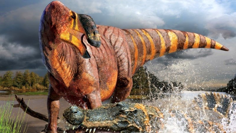
The largest predatory dinosaur ever found terrorised the water more than the land, according to remarkable fossils dug up in the Moroccan Sahara.

The bones show that the meat-eating Spinosaurus spent most of its time in water, making it the first known dinosaur to have adopted a semi-aquatic lifestyle.

It had small nostrils far back on its crocodile-like skull which allowed it to breathe when its head was partially submerged. It had stubby legs, long feet and large, flat claws, leading experts to suspect it had webbed feet.

The teeth are not the sharp steak-knife weapons seen in land predators, but conical ones better suited to impaling soft prey such as fish.

“The animal we are resurrecting today is so bizarre, it is going to force dinosaur experts to rethink many things they thought they knew about dinosaurs,” said Nizar Ibrahim, a palaeontologist at Chicago University. “So far, Spinosaurus is the only dinosaur that shows these adaptations.

An adult spinosaurus weighed up to 20 tonnes and reached 15 metres long, making it longer than the largest tyrannosaurus rex specimen. In the water, much of the beast would have been submerged, save for the two-metre sail on its back.

Many experts have long believed that spinosaurus lived in water, based on studies of its anatomy and habitats. The idea was boosted by Chinese scientists who found that spinosaur teeth carried the chemical signature of a marine diet.

The mounted skeletal cast of the Spinosaurus aegyptiacus, a 50-foot (15-meter) long,  National Geographic Society in Washington, September 11, 2014. REUTERS/Jim Bourg

Spinosaurus was first identified from bones dug up in the western desert of Egypt in 1911. The bones, dated to 95m years ago, were described by the German palaeontologist Ernst Stromer, but were destroyed when the RAF accidentally bombed Munich’s state palaeontology museum in April 1944.

The latest analysis comes after researchers brought together Stromer’s surviving notes, old museum specimens, and new spinosaur fossils found in 97m-year-old cliff sediments known as the Kem Kem beds in the Moroccan Sahara.

The most important fossil was a partial skeleton that had apparently found its way from a local fossil collector to a museum in Milan. Ibrahim said he had seen the fossils on a trip to Italy and realised they looked familiar. The sighting led him on an unlikely journey.

In 2008, Ibrahim was in Erfoud, a town near the border with Algeria, and had been approached by a man carrying a cardboard box. In it were spinosaur tail spines. Ibrahim was convinced they belonged to the same fossil as the remains in Milan. He set about tracking the man down to find out where the fossils had been excavated and to repatriate the remains to Morocco.

Ibrahim knew nothing about the man other than that he had a moustache, which did little to boost his hopes of success. But after much searching he had a stroke of luck. “We were in a cafe in Erfoud and I saw my dreams going down the drain. I thought we were never going to find the guy. But at that very moment … a person walked past our table. I caught a glimpse of his face and immediately recognised it. It was the man we were looking for.”

He took them to where he had found the spinosaur fossils. There, Ibrahim and his colleagues discovered more spinosaurus remains, including teeth, and vertebrae and pieces of jaw.

Now desert, the Kem Kem beds were once criss-crossed with rivers teeming with car-sized coelacanths, seven-metre-long sawfish, giant lungfish, sharks and several species of crocodile-like predators. It was the wrong place for a swim but bountiful for a fearsome spinosaur.

Inspecting the bones, researchers found neurovascular openings on the spinosaur snout, which are thought to have harboured pressure sensors to detect movement of prey in the water. They also found bad news for the makers of Jurassic Park III which features a villainous spinosaur walking on its hind legs. The animal’s centre-of-gravity was too far forward to balance that way, the researchers claim. Instead, the beast seems to have walked on all fours, making it the only meat-eating dinosaur known to do so. Details of the findings are reported in the journal Science.

Paul Barrett, a dinosaur expert at the Natural History Museum in London, said the evidence for spinosaurs living a semi-aquatic life was compelling before the latest fossils were described. But he added that if the latest collection of bones belonged to a single animal they were hugely valuable because other spinosaur remains are so scant.

“I really want to know how confident they are that all the bones belong to same specimen,” he said. Fossils are often sold piece by piece, so confirming the provenance of the remains is particularly important. “The only person who saw it in the ground is the fossil dealer,” Barrett said.

Spinosaurus will star in a new exhibition at the National Geographic Museum in Washington DC, opening on Friday. It will feature in a National Geographic/NOVA special, airing at 9pm on PBS on 5 November.

Note : The above story is based on materials provided by Ian Sample,The Guardian

Salween River

Salween drainage area

The Salween is a river, about 2,815 kilometres (1,749 mi) long, that flows from the Tibetan Plateau into the Andaman Sea in Southeast Asia. It drains a narrow and mountainous watershed of 324,000 square kilometres (125,000 sq mi) that extends into the countries of China, Burma and Thailand. Steep canyon walls line the swift, powerful and undammed Salween, one of the longest free-flowing rivers in the world. Its extensive drainage basin supports a biodiversity comparable with the Mekong and is home to about 7 million people. In 2003, key parts of the mid-region watershed of the river were included within the Three Parallel Rivers of Yunnan Protected Areas, a UNESCO World Heritage Site.


The people who live on the Salween are relatively isolated from the rest of the world. The river is only navigable up to 90 kilometres (56 mi) from the mouth, and only in the rainy season.

The Burma Road was constructed between 1937 and 1938 during the Second Sino-Japanese War and crossed the river at the Huitong bridge. The Huitong bridge was blown by the retreating Chinese army and the river became the frontline from 1942 to 1944. The Salween Campaign of World War II, was launched in order to liberate occupied China and open the Burma Road again and connect it to the Ledo Road.

Logging began on the mountains surrounding the Salween in the late 20th century, and has damaged the river’s ecology. In recent years, there have been a number of proposals to dam the Salween river in China, prompting environmental concerns and wide opposition. Construction of at least one dam on a tributary of the Salween are currently underway in China’s Yunnan province, and more are expected to follow.

Geography

The Salween rises at 5,450 metres (17,880 ft) in the Qinghai Mountains on the Tibetan Plateau, near the headwaters of the Mekong and Yangtze rivers. It initially flows west but then very shortly makes a great bend to the east, entering the Chinese province of Yunnan and the Three Parallel Rivers of Yunnan Protected Area, a World Heritage Site. Here, the Salween—called the Nu or Nujiang—has been proposed for a series of enormous dams that would theoretically generate more power than Three Gorges Dam, currently the world’s largest hydroelectric station. It then makes a wide southward arc between the Tibetan and Yunnan-Guizhou Plateaus, dropping into what is often known as the “Grand Canyon of the East” or “China’s Grand Canyon”, a 4,000-metre (13,000 ft)-deep gorge that takes it past the Chinese border into northeastern Burma through Shan State and Kayah State,
Mawlamyaing (formerly Moulmein) on the Salween delta

A sharp bend west and another south takes the Salween between the great mountain ranges of eastern Burma, the Daen Lao Range, a subrange of the Shan Hills, followed by the Dawna Hills in the east and the Karen Hills in the west, the river then receives the Pai River also from the left and flows through Salawin National Park to join the Moei River from the east as it approaches Thailand, where it is called the Salawin, forming the Burma-Thailand boundary for about 120 kilometres (75 mi), before re-entering Burma, passing through Karen State and Mon State. The river finally breaks out of its gorge about 250 kilometres (160 mi) from the mouth, and slows down dramatically as it courses through a series of agricultural valleys. About 89 kilometres (55 mi) from the mouth the river finally widens and deepens enough to become navigable for large watercraft. In quick succession it receives Dontham River from the right and Gyaing River from the left, from where the river turns west, flowing under Thanlwin Bridge and widening into a small river delta at Mawlamyaing (formerly Moulmein). This region is the most heavily developed on the river and contains most of the basin’s population.

Near the mouth the river has an average annual discharge of 1,659 cubic metres per second (58,600 cu ft/s), although this varies widely. The river’s base flow is provided by Tibetan glaciers, although it swells dramatically by the time it reaches the lowlands near the coast, especially in monsoon season.

Geology

Much of the watershed consists of one canyon generally paralleling the crustal convergence of the Indian subcontinent and mainland Asia. When India collided with Asia approximately 50 million years ago, many geographical features in the region were forced upwards to enormous heights, forming such landmarks as the Himalayas, Qinghai Shan, the Tibetan Plateau, and the eastern Burma massif. To date, India has pushed the boundary of the original Asian continent nearly 2,000 kilometres (1,200 mi) northwards. Evidence suggests that the southern Tibetan Plateau saw uplift as recently as 15-10 million years ago. The orogenic belt generally trends east to west near the northern part of the Subcontinent and makes a southward arc along with the Salween River on the eastern side. The upper course of the Salween flows through a region dominated by marine sedimentary rock that originally lay at the bottom of the Indian Ocean. This rock was uplifted to a height of thousands of metres by the India-Asia orogeny and is rapidly being eroded away by the Salween. Fault lines are strewn throughout the Salween basin, also generally following the pattern of the mountains and river.

Note : The above story is based on materials provided by Wikipedia

Scientists report first semiaquatic dinosaur, Spinosaurus

Digital model of a swimming Spinosaurus. Credit: University of Chicago Fossil Lab

Scientists are unveiling what appears to be the first truly semiaquatic dinosaur, Spinosaurus aegyptiacus. New fossils of the massive Cretaceous-era predator reveal it adapted to life in the water some 95 million years ago, providing the most compelling evidence to date of a dinosaur able to live and hunt in an aquatic environment. The fossils also indicate that Spinosaurus was the largest known predatory dinosaur to roam Earth, measuring more than nine feet longer than the world’s largest Tyrannosaurus rex specimen.
These findings, to be published Sept. 11 in the journal Science online at the Science Express website, are also featured in the October National Geographic magazine cover story available online Sept. 11. In addition, Spinosaurus will be the subject of a new exhibition at the National Geographic Museum, opening Sept. 12, as well as a National Geographic/NOVA special airing on PBS Nov. 5 at 9 p.m.

An international research team — including paleontologists Nizar Ibrahim and Paul Sereno from the University of Chicago; Cristiano Dal Sasso and Simone Maganuco from the Natural History Museum in Milan, Italy; and Samir Zouhri from the Université Hassan II Casablanca in Morocco — found that Spinosaurus developed a variety of previously unknown aquatic adaptations.

The researchers came to their conclusions after analyzing new fossils uncovered in the Moroccan Sahara and a partial Spinosaurus skull and other remains housed in museum collections around the world as well as historical records and images from the first reported Spinosaurus discovery in Egypt more than 100 years ago. According to lead author Ibrahim, a 2014 National Geographic Emerging Explorer, “Working on this animal was like studying an alien from outer space; it’s unlike any other dinosaur I have ever seen.”

The aquatic adaptations of Spinosaurus differ significantly from earlier members of the spinosaurid family that lived on land but were known to eat fish. These adaptations include:

  • Small nostrils located in the middle of the skull. The small size and placement of the nostrils farther back on the skull allowed Spinosaurus to breathe when part of its head was in water.
  • Neurovascular openings at the end of the snout. Similar openings on crocodile and alligator snouts contain pressure receptors that enable them to sense movement in water. It’s likely these openings served a comparable function in Spinosaurus.
  • Giant, slanted teeth that interlocked at the front of the snout. The conical shape and location of the teeth were well-suited for catching fish.
  • A long neck and trunk that shifted the dinosaur’s center of mass forward. This made walking on two legs on land nearly impossible, but facilitated movement in water.
  • Powerful forelimbs with curved, blade-like claws. These claws were ideal for hooking or slicing slippery prey.
  • A small pelvis and short hind legs with muscular thighs. As in the earliest whales, these adaptations were for paddling in water and differ markedly from other predatory dinosaurs that used two legs to move on land.
  • Particularly dense bones lacking the marrow cavities typical to predatory dinosaurs. Similar adaptations, which enable buoyancy control, are seen in modern aquatic animals like king penguins.
  • Strong, long-boned feet and long, flat claws. Unlike other predators, Spinosaurus had feet similar to some shorebirds that stand on or move across soft surfaces rather than perch. In fact, Spinosaurus may have had webbed feet for walking on soft mud or paddling.
  • Loosely connected bones in the dinosaur’s tail. These bones enabled its tail to bend in a wave-like fashion, similar to tails that help propel some bony fish.
  • Enormous dorsal spines covered in skin that created a gigantic “sail” on the dinosaur’s back. The tall, thin, blade-shaped spines were anchored by muscles and composed of dense bone with few blood vessels. This suggests the sail was meant for display and not to trap heat or store fat. The sail would have been visible even when the animal entered the water.

More than a century ago, German paleontologist Ernst Freiherr Stromer von Reichenbach first discovered evidence of Spinosaurus in the Egyptian Sahara. Sadly, all of Stromer’s fossils were destroyed during the April 1944 Allied bombing of Munich, Germany. Ibrahim, however, was able to track down Stromer’s surviving notes, sketches and photos in archives and at the Stromer family castle in Bavaria to supplement Stromer’s surviving publications.

The new Spinosaurus fossils were discovered in the Moroccan Sahara along desert cliffs known as the Kem Kem beds. This area was once a large river system, stretching from present-day Morocco to Egypt. At the time, a variety of aquatic life populated the system, including large sharks, coelacanths, lungfish and crocodile-like creatures, along with giant flying reptiles and predatory dinosaurs.

The most important of the new fossils, a partial skeleton uncovered by a local fossil hunter, was spirited out of the country. As a result, critical information about the context of the find was seemingly lost, and locating the local fossil hunter in Morocco was nearly impossible. Remarked Ibrahim, “It was like searching for a needle in a desert.” After an exhaustive search, Ibrahim finally found the man and confirmed the site of his original discovery.

To unlock the mysteries of Spinosaurus, the team created a digital model of the skeleton with funding provided by the National Geographic Society. The researchers CT scanned all of the new fossils, which will be repatriated to Morocco, complementing them with digital recreations of Stromer’s specimens. Missing bones were modeled based on known elements of related dinosaurs.

According to Maganuco, “We relied upon cutting-edge technology to examine, analyze and piece together a variety of fossils. For a project of this complexity, traditional methods wouldn’t have been nearly as accurate.”

The researchers then used the digital model to create an anatomically precise, life-size 3-D replica of the Spinosaurus skeleton. After it was mounted, the researchers measured Spinosaurus from head to tail, confirming their calculation that the new skeleton was longer than the largest documented Tyrannosaurus by more than 9 feet.

According to Sereno, head of the University of Chicago’s Fossil Lab, “What surprised us even more than the dinosaur’s size were its unusual proportions. We see limb proportions like this in early whales, not predatory dinosaurs.”

Added Dal Sasso, “In the last two decades, several finds demonstrated that certain dinosaurs gave origins to birds. Spinosaurus represents an equally bizarre evolutionary process, revealing that predatory dinosaurs adapted to a semiaquatic life and invaded river systems in Cretaceous North Africa.”

The life-size skeletal replica will be the centerpiece of a new exhibition at the National Geographic Museum in Washington, D.C., titled “Spinosaurus: Lost Giant of the Cretaceous.” The exhibition, which runs from Sept. 12, 2014, to April 12, 2015, brings to life the story of Spinosaurus, from Stromer’s original discoveries to the dedicated efforts of the international research team working to unlock its secrets.

For more information on this interactive, multimedia experience developed in collaboration with UChicagoTech, the university’s Center for Technology Development & Ventures, visit ngmuseum.org.

The global search to uncover the Spinosaurus skeleton and its mysteries will also be featured in a National Geographic/NOVA special, “Bigger Than T.rex,” airing on PBS Nov. 5, 2014, at 9 p.m.

Other authors of the Science paper are David Martill, University of Portsmouth, United Kingdom; Matteo Fabbri, University of Bristol, United Kingdom; Nathan Myhrvold, Intellectual Ventures; and Dawid Iurino, Sapienza Università di Roma in Italy. Important contributors to the making of the digital Spinosaurus include Tyler Keillor, Lauren Conroy and Erin Fitzgerald of the Fossil Lab at the University of Chicago.

Note : The above story is based on materials provided by University of Chicago. The original article was written by Claire Gwatkin Jones.

Microscopic diamonds suggest cosmic impact responsible for major period of climate change

Credit: NASA

A new study published in The Journal of Geology provides support for the theory that a cosmic impact event over North America some 13,000 years ago caused a major period of climate change known as the Younger Dryas stadial, or “Big Freeze.”
Around 12,800 years ago, a sudden, catastrophic event plunged much of the Earth into a period of cold climatic conditions and drought. This drastic climate change—the Younger Dryas—coincided with the extinction of Pleistocene megafauna, such as the saber-tooth cats and the mastodon, and resulted in major declines in prehistoric human populations, including the termination of the Clovis culture.

With limited evidence, several rival theories have been proposed about the event that sparked this period, such as a collapse of the North American ice sheets, a major volcanic eruption, or a solar flare.

However, in a study published in The Journal of Geology, an international group of scientists analyzing existing and new evidence have determined a cosmic impact event, such as a comet or meteorite, to be the only plausible hypothesis to explain all the unusual occurrences at the onset of the Younger Dryas period.

Researchers from 21 universities in 6 countries believe the key to the mystery of the Big Freeze lies in nanodiamonds scattered across Europe, North America, and portions of South America, in a 50-million-square-kilometer area known as the Younger Dryas Boundary (YDB) field.

Microscopic nanodiamonds, melt-glass, carbon spherules, and other high-temperature materials are found in abundance throughout the YDB field, in a thin layer located only meters from the Earth’s surface. Because these materials formed at temperatures in excess of 2200 degrees Celsius, the fact they are present together so near to the surface suggests they were likely created by a major extraterrestrial impact event.

In addition to providing support for the cosmic impact event hypothesis, the study also offers evidence to reject alternate hypotheses for the formation of the YDB nanodiamonds, such as by wildfires, volcanism, or meteoric flux.

The team’s findings serve to settle the debate about the presence of nanodiamonds in the YDB field and challenge existing paradigms across multiple disciplines, including impact dynamics, archaeology, paleontology, limnology, and palynology.

More information:
C. R. Kinzie, et al., “Nanodiamond-Rich Layer across Three Continents Consistent with Major Cosmic Impact at 12,800 Cal BP,” The Journal of Geology 2014, 122(5). www.jstor.org/stable/10.1086/677046

Note : The above story is based on materials provided by University of Chicago

Deep mission: Japan takes aim at the source of megaquakes

Even in port, it’s easy to see how the research vessel Chikyu got its nickname. From the waterline to the top of its drilling derrick, the vessel also known as “Godzilla-Maru” towers nearly 30 stories tall.

It’s longer than two football fields.

A helicopter landing pad juts over the bow. The two midship cranes are powerful enough to hoist a Boeing 787.

The Japanese government spent more than $500 million to build this monster of a ship with one goal in mind: to decipher the inner workings of a fault capable of unleashing a disaster far worse than the 2011 Tohoku earthquake and tsunami.

In 2016, Japan hopes to complete a nine-year mission to drill into the heart of the Nankai Trough, a 500-mile-long fault that threatens some of the country’s most populous areas.

The borehole will extend more than three miles into the Earth’s crust, shattering the record for scientific drilling in the ocean.

Only Japan would bankroll such complex and costly seismic research. In a country rattled by more than a thousand sizable earthquakes every year, no threat is more pressing.

But the results unearthed by Chikyu will also be relevant to the U.S. Pacific Northwest, where an offshore fault called the Cascadia Subduction Zone stretches from Vancouver Island to Northern California.

“Cascadia and Nankai are so strikingly similar, we call them sister subduction zones,” said Kelin Wang of the Geological Survey of Canada. “By studying Nankai, we North Americans will benefit, too.”

Subduction zones, where an oceanic plate dives – or subducts – under a continental plate, are responsible for the world’s most powerful earthquakes and tsunamis.

But subduction zones are much tougher to study than landlocked faults. The boundaries where the plates collide are almost always miles offshore, under thousands of feet of water.

Japan has installed seismometers and other sensors on the seafloor to detect small earthquakes and monitor how the plates warp as strain builds. But even those instruments provide only a superficial view.

“Earthquakes don’t happen on the surface,” said Harold Tobin, co-chief scientist for the drilling project, called the Nankai Trough Seismogenic Zone Experiment. “They happen kilometers down in the Earth.”

Chikyu was designed to go deep, penetrating the portion of the fault where megaquakes are born. Called the seismogenic zone, it’s the region where rocks that are normally locked suddenly jerk past each other in what scientists call a megathrust quake.

(There’s no danger the drilling will trigger an earthquake, Tobin said. No fluid is injected into the rock, and the foot-wide hole is too tiny to affect the stress levels in such an enormous structure.)

By extracting cores from the fault, researchers will be able to analyze the rock itself, said Nobu Eguchi, program manager for science operations at Japan’s Center for Deep Earth Exploration (CDEX). “Nobody has ever seen this material before.”

Properties like stiffness, strength, mineral composition and fluid content are all crucial to understanding how plates become locked and what happens when the pressure reaches the breaking point.

“One of the key things people are working on is essentially trying to reproduce fault-zone conditions in the laboratory using material that is cored from the fault rock itself,” said Pennsylvania State University geologist Demian Saffer, part of the Chikyu science team.

When the deepest borehole is finished, scientists will install instruments to continuously measure motion on the fault, the accumulation of strain and changes in the rock due to tectonic forces. “Those are things you can’t measure unless you have sensors in the rock,” Saffer said.

Scientists hope the instruments will capture the run-up to the next big quake. If so, that data might help identify warning signs that precede a rupture.

The search for such precursors has so far been futile, but researchers are only beginning to look on – and under – the seafloor, Tobin said. There’s some evidence that the Tohoku quake was triggered by slow slip that pushed the fault over its edge. It’s not clear how common or significant the phenomenon will be, but the best way to monitor such subtle motion is with borehole instruments as close to the action as possible, Tobin said.

Saffer and Japanese scientists have already installed one set of instruments in a half-mile-deep borehole drilled by Chikyu, part of a series of 15 holes of varying depths along the Nankai Trough.

Historic records show quakes of about magnitude 8 strike on the fault every 90 to 200 years. The most recent ruptured adjacent segments in 1944 and 1946, killing nearly 3,000 people.

Japan’s population has increased significantly since then, and studies warn that 320,000 people could perish in a worst-case scenario. That’s more than 10 times the toll from the Tohoku quake and tsunami, which struck on a different subduction zone.

Off the U.S. coast, the 700-mile-long Cascadia fault hasn’t ripped as frequently as the Nankai fault – but the quakes can be more powerful. Geologic records reveal a history of magnitude 9 megaquakes and tsunamis every 500 years, on average. But some were separated by as little as two centuries – and the last was more than 300 years ago.

Scientists don’t know as much about the mechanics of the Cascadia fault, partly because there’s been so little offshore drilling in the Northwest.

Beginning in the early 1990s, several shallow boreholes – up to about 1,000 feet – were sunk off British Columbia, Washington and Oregon. A few are still being employed as simple pressure gauges to measure motion of the seafloor. Next year, scientists will install a tiltmeter and other sensors in an existing borehole near the subduction zone.

But those projects only scratch the surface.

On land, the deepest seismic borehole extends about two miles into the San Andreas Fault. Scientists retrieved cores and installed sensors. But the instruments failed within weeks under the harsh conditions deep inside the Earth.

Chikyu has encountered its share of challenges as well, said Sean Toczko, a Virginia native who helps coordinate missions. During stomach-churning storms, crews have to pull up the drill pipe so it won’t snap off, he said. Even when the weather is good, holding the ship stationary requires constant adjustment via a computerized thruster system that reads signals from GPS satellites.

Chikyu is pushing the boundary for scientific drilling, penetrating zones of fractured rock where even oil companies have little experience, Toczko said.

It might seem surprising that so many Americans work on a ship owned by the Japan Agency for Marine-Earth Science and Technology. But the effort is truly international, Toczko said.

Most of the ship’s crew and many researchers are Japanese, but scientists from around the world are part of the team. Many of the drillers are Scottish veterans of North Sea oil rigs.

Chikyu is the first research ship to employ techniques from the oil industry, like the use of an outer pipe called a riser to stabilize the main drill pipe and prevent the hole from collapsing.

Drill bosses use joysticks to guide the pipe through miles of water and hit a tiny bull’s-eye on the seafloor. One scientist likened it to threading a needle on the floor from shoulder height.

The atmosphere on the ship is most electric when the crew is extracting cores, said Eguchi, the CDEX program manager. Scientists form an assembly line and work around the clock to run the rock through a series of scans and tests. “The lab is equipped with the type of sophisticated instruments you normally only see in a university,” he said.

In January, Chikyu reached a depth of 1.8 miles – but not without difficulty. The borehole kept collapsing, and operators are still looking for solutions, Eguchi said.

They hope to resume drilling in early 2016. Between science missions, the ship contracts out for oil and gas exploration to offset operating costs as high as $400,000 a day.

The cores already collected are yielding some unexpected insights.

In one area surprisingly close to the surface, researchers found signs that the frictional force from a past quake heated a thin band of rock to nearly 600 degrees.

A rapid-response mission to drill into the fault that ruptured in 2011 revealed a slippery layer of clay that also ripped all the way to the surface, explaining why the ocean floor lurched 160 feet and triggered such a massive tsunami.

The results raise questions about whether parts of the Cascadia Subduction Zone might be equally slippery and capable of generating bigger tsunamis than expected.

“We need to study our fault-zone material more carefully,” Wang said. “Our knowledge is quite limited because we don’t have this type of drilling.”

Scientists hope to use a U.S. ship to drill shallow scientific boreholes off the Northwest coast – both for rock collection and instrumentation. But that vessel is booked for the next four years.

In the meantime, researchers are using indirect methods to probe the fault. Temporary arrays of ocean-bottom seismometers have been recording the location of tiny quakes. And scientists recently compiled subsurface pictures by bouncing acoustic signals off the seafloor and measuring how the sound waves penetrate and ricochet.

That’s the kind of information necessary to guide future research drilling in the region, Tobin said.

“We know the structure on a big scale, but the kind of detail you need for a scientific drilling project is a whole different ballgame.”

Once those gaps are filled in, a Chikyu mission to Cascadia would make a lot of sense – if funding is available, Tobin said. Japan is already considering proposals to send the vessel to subduction zones off Costa Rica and New Zealand.

“I’m an optimist,” Tobin said. “I think Cascadia has a great chance of being a future Chikyu project.”

Note : The above story is based on materials provided by ©2014 The Seattle Times
Distributed by MCT Information Services

Ancient swamp creature had lips like Mick Jagger

Top and side views of a fossilized jaw bone of an ancient creature recently named after Mick Jagger, in honor of the animal’s big, sensitive lips and snout. The animal’s jaw bones suggest it was roughly the size of a small deer. Credit: Photo courtesy of Gregg Gunnell, Duke Lemur Center

Sir Mick Jagger has a new animal named after him. Scientists have named an extinct swamp-dwelling creature that lived 19 million years ago in Africa after the Rolling Stones frontman, in honor of a trait they both share — their supersized lips.
“We gave it the scientific name Jaggermeryx naida, which translates to ‘Jagger’s water nymph,'” said study co-author Ellen Miller of Wake Forest University. The animal’s fossilized jaw bones suggest it was roughly the size of a small deer and akin to a cross between a slender hippo and a long-legged pig.

Researchers uncovered the fossils — consisting of multiple jawbone fragments — amid the sand dunes and eroded rock of a remote site in the Egyptian desert.

The creature belonged to a family of extinct hoofed animals called anthracotheres. Jaggermeryx is one of six species of anthracotheres found at the site. What distinguished it from other members of this family was a series of tiny holes on either side of its jaw that held the nerves providing sensation to the chin and lower lip.

“The animal probably had a highly innervated muzzle with mobile and tactile lips, thus the Jagger reference,” said Duke University paleontologist and study co-author Gregg Gunnell.

The Egyptian site where the fossils were found is mostly desert today, but geological data suggest that millions of years ago it was a lush tropical delta crisscrossed by rivers and swampland.

Preliminary measurements of the relative amounts of different isotopes in the animal’s bones suggest that it probably ate plants.

“It may have used its sensitive snout to forage along river banks, scooping up plants with its lower teeth and large lips,” Miller said.

The Jaggermeryx fossils, which now reside in collections at Duke, the Cairo Geological Museum and Cairo University, were found alongside fossilized catfish, turtles, waterbirds and crocodile poop.

“Some of my colleagues suggested naming the new species after Hollywood star Angelina Jolie, because she also has famous lips. But for me it had to be Mick,” said Miller, who recently read the autobiography of Jagger’s musical partner Keith Richards.

“I was a HUGE Rolling Stones fan in my day,” Gunnell said. “‘Exile on Main St.’ and ‘Let it Bleed’ were my favorite albums.”

Note : The above story is based on materials provided by Duke University.

Groundwater tied to human evolution

Insert shows with arrow the location of study area in eastern Africa. Map of the Northern Tanzanian Divergence Zone depicts the East African Rift System (EARS), containing Lake Natron (north), diverging around the Ngorongoro Volcanic Highland massif and splitting into two separate rift valleys (Lake Eyasi on west) and Lake Manyara (on east). Prevailing wind is from the east. Olduvai basin lies to the west of and in the rain shadow of Ngorongoro. Credit: Map made by Sara Mana, http://www.geomapapp.org; from Cuthbert et al., doi:10.1371/journal.pone.0107358.g001

Our ancient ancestors’ ability to move around and find new sources of groundwater during extremely dry periods in Africa millions of years ago may have been key to their survival and the evolution of the human species, a new study shows.
The research — published in the journal PLOS ONE — combines geological evidence from the Olduvai sedimentary basin in Northern Tanzania, which formed about 2.2 million years ago, and results from a hydrological model.

It shows that while water in rivers and lakes would have disappeared as the climate changed due to variations in Earth’s orbit, freshwater springs fed by groundwater could have stayed active for up to 1000 years without rainfall.

“A major unknown connected with human evolution in this climatically turbulent environment is the availability of resources, particularly freshwater,” says lead author Dr Mark Cuthbert, holder of a European Community-funded Marie Curie Research Fellowship at UNSW’s Connected Waters Initiative and University of Birmingham (UK).

Potable water in rivers or lakes in the region is likely to have been scarce, owing to salinity, drought and the short-lived flow of streams. Groundwater may have provided “a key alternative potable resource for sustaining life” in this environment.

“Springs and groundwater-fed habitats could have played a decisive role in the survival and dispersal of hominins in times when potable surface water was limited,” Dr Cuthbert said.

Geological evidence pointed to the springs being active during the driest periods of climate fluctuations that occurred around 1.8 million years ago, a critical period for hominin evolution.

In addition, modelling by the researchers showed springs at Olduvai may have stayed active for hundreds of years without rainfall.

“As surface water sources became more scarce during a given climate cycle, the only species to survive may have been those with adaptations for sufficient mobility to discover a new and more persistent groundwater source, or those already settled within home range of such a resource,” co-author Professor Gail Ashley, Rutgers University (US), said.

“Such groundwater refugia may have been sites for intense competition between hominin and other animal species and hence selective pressure favouring those who could maintain access to water, something for which there is no substitute.

“Furthermore we speculate that, during wetter periods, springs may have formed ways of ‘bridging’ longitudinal dispersal of hominins between larger freshwater bodies or rivers providing a critical resource during hominin migration within and out of Africa,” Professor Ashley said.

Professor Andy Baker, Director of UNSW’s Connected Waters Initiative, welcomed the study, adding, “Here in Australia we are very aware of the importance of groundwater to our national economy today.

“This study clearly suggests that we should consider the role of groundwater throughout the history of the settlement of our continent.”

The scientists said more research is needed to test their theories about the role that groundwater may have played in human evolution and dispersal.

Note : The above story is based on materials provided by University of New South Wales.

New study reconstructs mega-earthquakes timeline in Indian Ocean

UM Rosenstiel School Geologist Kelly Jackson documents sediments deposited by the 2004 Indian Ocean tsunami on the southeastern coast of Sri Lanka. Credit: UM Rosenstiel School

A new study on the frequency of past giant earthquakes in the Indian Ocean region shows that Sri Lanka, and much of the Indian Ocean, is affected by large tsunamis at highly variable intervals, from a few hundred to more than one thousand years. The findings suggest that the accumulation of stress in the region could generate as large, or even larger tsunamis than the one that resulted from the 2004 magnitude-9.2 Sumatra earthquake.
Researchers from the University of Miami (UM) Rosenstiel School of Marine and Atmospheric Science and the University of Peradeniya in Sri Lanka collected and analyzed 22 sediment cores from Karagan Lagoon, Hambantota in southeastern Sri Lanka, to expand the historical record of giant earthquakes along the Sumatra-Andaman subduction zone, where the Indo-Australian plate and Eurasian plate meet. Using sand deposited in the lagoon during the 2004 Indian Ocean tsunami and seven older paleo-tsunami deposits as proxies for large earthquakes in the region, the scientists reconstructed the timeline for mega-earthquakes along the Indian Ocean’s plate boundary from Myanmar to Indonesia, assuming that the tsunamis were all generated by large earthquakes.

“In Sri Lanka, coastal lagoons were inundated by this tsunami and others that occurred over thousands of years,” said Gregor Eberli, professor of Marine Geosciences and director of UM’s CSL — Center for Carbonate Research. “These lagoons are ideal repositories for tsunami sand layers because after deposition, the tsunami sands were sealed with mud.”

The Dec. 26, 2004 M-9.2 Sumatra earthquake resulted in a trans-oceanic tsunami, with wave heights up to 100 feet (30 meters) in some places, which impacted much of the Indian Ocean region causing widespread damage in southeastern Sri Lanka.

During the a 7,000-year record of Indian Ocean tsunamis preserved in the sediment, the research team found evidence that estimated the time period between consecutive tsunamis from 181 (up to 517) years and 1045 (± 334) years. The longest period was nearly twice the time period prior to the 2004 earthquake.

“These results are very important to better understand the tsunami hazard in Sri Lanka,” said Kelly Jackson, UM Rosenstiel School Ph.D. candidate and lead author of the study.

“A scary result is a 1000-year time period without a tsunami, which is nearly twice as long as the lull period prior to the 2004 earthquake,” said Falk Amelung, professor of geophysics within the department of Marine Geosciences at the UM Rosenstiel School. “This means that the subduction zone is capable of generating earthquakes almost twice as big as in 2004, although we don’t have any evidence yet that this actually happened.”

“The 2004 tsunami caught us completely by surprise, although we should have known better because there is a Sri Lankan legend in which the sea came ashore in 200 B.C.,” says Chandra Jayasena, a geologist at the University of Peradeniya. “We now need to study other lagoons to further expand the historical record of large tsunami-generating earthquakes in the region and get a better understanding of the earthquake frequency in this highly populated region.”

The region’s subduction zone exhibits great variability in rupture modes, putting it on the list with the Cascadia Subduction Zone, which stretches from Vancouver Island to northern California and Chile, according to the authors.

Note : The above story is based on materials provided by University of Miami Rosenstiel School of Marine & Atmospheric Science.

Simulating the south Napa earthquake

Researchers are using data from the South Napa earthquake to help validate models. These figures compare the (left) observed intensity of ground motion from seismic stations of the California Integrated Seismic Network “ShakeMap” with the (right) simulated shaking (peak ground velocity) from SW4 simulations using UC Berkeley Professor Doug Dreger’s source model and the USGS 3D geologic/seismic model. Both figures use a similar color scale, though they cover different spatial domains.

Lawrence Livermore seismologist Artie Rodgers is tapping into LLNL’s supercomputers to simulate the detailed ground motion of last month’s magnitude 6.0 south Napa earthquake.

The Napa tremor is the largest to hit the Bay Area since the magnitude 6.9 Loma Prieta event in 1989.
Using descriptions of the earthquake source from Professor Douglas Dreger of the University of California Berkeley Seismological Laboratory, Rodgers is determining how the details of the rupture process and 3D geologic structure, including the surface topography, may have impacted the ground motion. The earthquake ruptures from its epicenter south to north, directing energy toward Napa.

Seismic simulations allow scientists to better understand the distribution of shaking and damage that can accompany earthquakes, including possible future “scenario” earthquakes. The simulations are only as valid as the elements going into the simulations, such as the source and subsurface models. Thus the recent earthquake provides data to validate methods and models. Simulations are performed with the LLNL-developed SW4 code by Anders Petersson and Bjorn Sjogreen of the Lab’s Computation Directorate.

Dreger developed a model of the earthquake source based on the recorded ground motions. Rodgers is combining that source model with a 3D subsurface model developed by the U.S. Geological Survey (Menlo Park) to simulate the observed motions.

“This earthquake will help us improve the 3D model to better fit the observed seismic motions, especially at higher frequencies than previously possible” Rodgers said.

Compared to the Loma Prieta quake, the current seismic instruments have vastly improved and provide better spatial sampling of the source and geological structure.

Damage occurred more in the sedimentary basins such as the Napa and Sonoma valleys and San Pablo Basin because they are made of weaker rock. Mountain regions close by felt less shaking because they are composed of harder rock.

The half meter slip on a 12-kilometer segment of the West Napa fault was not the most likely place for a large earthquake to occur in the Bay Area. “It’s a bit of a surprise at this site, though there was a magnitude 6.3 possibly on this fault back in 1893,” Rodgers said. The northward direction of the rupture is well established, but details of the spatial and temporal evolution of the rupture remain to be discovered.

Most experts expect the Hayward-Rodgers Creek Fault system will be the next major Bay Area earthquake. In fact, there is a 30 percent chance that the Hayward/Rodgers Creek fault will rupture with a 6.7 magnitude or greater quake in the next 30 years, an event that would significantly affect the greater Bay Area. However, an event on the Greenville fault, which ruptured in January 1980, could be more damaging to the Tri Valley.

For now, Rodgers is focusing on the Napa event with colleagues at LLNL, UC Berkeley and the USGS. He said the current simulation capabilities far exceed what existed in 1989, allowing his team to perform higher resolution numerical experiments more easily and quickly.

“Also, we now have more high quality and rapidly available data as well as automated results to inform the public of details when an earthquake happens,” he said. “We’re getting information in a couple of minutes or hours rather than a couple of days.”

Rodgers said the prototype Earthquake Early Warning system operated by UC Berkeley provided an alert five seconds before the strong shaking arrived in Berkeley. This system worked well but could provide more warning by densifying and upgrading the region’s seismic network. LLNL and its employees could benefit from subscribing to this test system and expanding network coverage, especially near the Greenville fault.

Note : Note : The above story is based on materials provided by Lawrence Livermore National Laboratory

Researchers say a major quake may occur off the coast of Istanbul

Satellite view of Istanbul and the Bosphorus strait. Credit: Public Domain

When a segment of a major fault line goes quiet, it can mean one of two things: The “seismic gap” may simply be inactive—the result of two tectonic plates placidly gliding past each other—or the segment may be a source of potential earthquakes, quietly building tension over decades until an inevitable seismic release.
Researchers from MIT and Turkey have found evidence for both types of behavior on different segments of the North Anatolian Fault—one of the most energetic earthquake zones in the world. The fault, similar in scale to California’s San Andreas Fault, stretches for about 745 miles across northern Turkey and into the Aegean Sea.

The researchers analyzed 20 years of GPS data along the fault, and determined that the next large earthquake to strike the region will likely occur along a seismic gap beneath the Sea of Marmara, some five miles west of Istanbul. In contrast, the western segment of the seismic gap appears to be moving without producing large earthquakes.

“Istanbul is a large city, and many of the buildings are very old and not built to the highest modern standards compared to, say, southern California,” says Michael Floyd, a research scientist in MIT’s Department of Earth, Atmospheric and Planetary Sciences. “From an earthquake scientist’s perspective, this is a hotspot for potential seismic hazards.”

Although it’s impossible to pinpoint when such a quake might occur, Floyd says this one could be powerful—on the order of a magnitude 7 temblor, or stronger.

“When people talk about when the next quake will be, what they’re really asking is, ‘When will it be, to within a few hours, so that I can evacuate?’ But earthquakes can’t be predicted that way,” Floyd says. “Ultimately, for people’s safety, we encourage them to be prepared. To be prepared, they need to know what to prepare for—that’s where our work can contribute”

Floyd and his colleagues, including Semih Ergintav of the Kandilli Observatory and Earthquake Research Institute in Istanbul and MIT research scientist Robert Reilinger, have published their seismic analysis in the journal Geophysical Research Letters.

In recent decades, major earthquakes have occurred along the North Anatolian Fault in a roughly domino-like fashion, breaking sequentially from east to west. The most recent quake occurred in 1999 in the city of Izmit, just east of Istanbul. The initial shock, which lasted less than a minute, killed thousands. As Istanbul sits at the fault’s western end, many scientists have thought the city will be near the epicenter of the next major quake.

To get an idea of exactly where the fault may fracture next, the MIT and Turkish researchers used GPS data to measure the region’s ground movement over the last 20 years. The group took data along the fault from about 100 GPS locations, including stations where data are collected continuously and sites where instruments are episodically set up over small markers on the ground, the positions of which can be recorded over time as the Earth slowly shifts.

“By continuously tracking, we can tell which parts of the Earth’s crust are moving relative to other parts, and we can see that this fault has relative motion across it at about the rate at which your fingernail grows,” Floyd says.

From their ground data, the researchers estimate that, for the most part, the North Anatolian Fault must move at about 25 millimeters—or one inch—per year, sliding quietly or slipping in a series of earthquakes.

As there’s currently no way to track the Earth’s movement offshore, the group also used fault models to estimate the motion off the Turkish coast. The team identified a segment of the fault under the Sea of Marmara, west of Istanbul, that is essentially stuck, with the “missing” slip accumulating at 10 to 15 millimeters per year. This section—called the Princes’ Island segment, for a nearby tourist destination—last experienced an earthquake 250 years ago.

Floyd and colleagues calculate that the Princes’ Island segment should have slipped about 8 to 11 feet—but it hasn’t. Instead, strain has likely been building along the segment for the last 250 years. If this tension were to break the fault in one cataclysmic earthquake, the Earth could shift by as much as 11 feet within seconds.

Although such accumulated strain may be released in a series of smaller, less hazardous rumbles, Floyd says that given the historical pattern of major quakes along the North Anatolian Fault, it would be reasonable to expect a large earthquake off the coast of Istanbul within the next few decades.

“Earthquakes are not regular or predictable,” Floyd says. “They’re far more random over the long run, and you can go many lifetimes without experiencing one. But it only takes one to affect many lives. In a location like Istanbul that is known to be subject to large earthquakes, it comes back to the message: Always be prepared.”

Note : The above story is based on materials provided by Massachusetts Institute of Technology

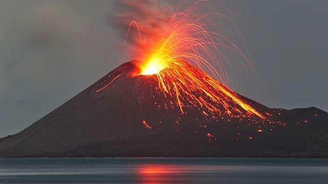
Underwater Volcano Eruption

Paleontologists discover new species of titanosaurian dinosaur in Tanzania

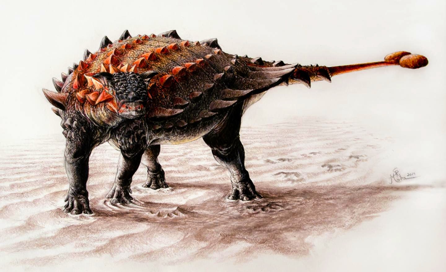
An artistic rendering of a deceased Rukwatitan bisepultus individual in the initial floodplain depositional setting from which the holotypic skeleton was recovered. Credit: Mark Witton, University of Portsmouth

Ohio University paleontologists have identified a new species of titanosaurian, a member of the large-bodied sauropods that thrived during the final period of the dinosaur age, in Tanzania. Although many fossils of titanosaurians have been discovered around the globe, especially in South America, few have been recovered from the continent of Africa.
The new species, named Rukwatitan bisepultus, was first spotted by scientists embedded in a cliff wall in the Rukwa Rift Basin of southwestern Tanzania. Using the help of professional excavators and coal miners, the team unearthed vertebrae, ribs, limbs and pelvic bones over the course of two field seasons.

CT scans of the fossils, combined with detailed comparisons with other sauropods, revealed unique features that suggested an animal that was different from previous finds — including those from elsewhere in Africa, according to a study the team published today in the Journal of Vertebrate Paleontology.

“Using both traditional and new computational approaches, we were able to place the new species within the family tree of sauropod dinosaurs and determine both its uniqueness as a species and to delineate others species with which it is most closely related,” said lead author Eric Gorscak, a doctoral student in biological sciences at Ohio University.

Rukwatitan bisepultus lived approximately 100 million years ago during the middle of the Cretaceous Period. Titanosaurian sauropods, the group that includes Rukwatitan, were herbivorous dinosaurs known for their iconic large body sizes, long necks and wide stance. Although not among the largest of titanosaurians, Rukwatitan is estimated to have a forelimb reaching 2 meters and may have weighed as much as several elephants.

The dinosaur’s bones exhibit similarities with another titanosaurian, Malawisaurus dixeyi, previously recovered in Malawi. But the two southern African dinosaurs are distinctly different from one another, and, most notably, from titanosaurians known from northern Africa, said co-author Patrick O’Connor, a professor of anatomy in the Ohio University Heritage College of Osteopathic Medicine.

The fossils of middle Cretaceous crocodile relatives from the Rukwa Rift Basin also exhibit distinctive features when compared to forms from elsewhere on the continent.

“There may have been certain environmental features, such as deserts, large waterways and/or mountain ranges, that would have limited the movement of animals and promoted the evolution of regionally distinct faunas,” O’Connor said. “Only additional data on the faunas and paleo environments from around the continent will let us further test such hypotheses.”

In addition to providing new data about species evolution in sub-Saharan Africa, the study also contributes to fleshing out the global portrait of titanosaurians, which lived in habitats across the globe through the end of the Cretaceous Period. Their rise in diversity came in the wake of the decline of another group of sauropods, the diplodocoids, which include the dinosaur Apatosaurus, the researchers noted. Scientists have found fossils for more than 30 titanosaurians in South America compared to just four in Africa.

“Much of what we know regarding titanosaurian evolutionary history stems from numerous discoveries in South America — a continent that underwent a steady separation from Africa during the first half of the Cretaceous Period,” Gorscak said. “With the discovery of Rukwatitan and study of the material in nearby Malawi, we are beginning to fill a significant gap from a large part of the world.”

Co-authors on the study are Nancy Stevens, a professor in the Ohio University Heritage College of Osteopathic Medicine, and Eric Roberts, a senior lecturer in the James Cook University of Australia.

The study was funded by the National Science Foundation, the National Geographic Society, the Ohio University Heritage College of Osteopathic Medicine and the Ohio University Office of the Vice President for Research and Creative Activity.

Note : The above story is based on materials provided by Ohio University.

Study traces ecological collapse over 6,000 years of Egyptian history

Carved rows of animals, including elephants, lions, a giraffe, and sheep, cover both sides of the ivory handle of a ritual knife from the Predynastic Period in Egypt. Credit: Charles Edwin Wilbour Fund, Brooklyn Museum

Depictions of animals in ancient Egyptian artifacts have helped scientists assemble a detailed record of the large mammals that lived in the Nile Valley over the past 6,000 years. A new analysis of this record shows that species extinctions, probably caused by a drying climate and growing human population in the region, have made the ecosystem progressively less stable.
The study, published September 8 in Proceedings of the National Academy of Sciences (PNAS), found that local extinctions of mammal species led to a steady decline in the stability of the animal communities in the Nile Valley. When there were many species in the community, the loss of any one species had relatively little impact on the functioning of the ecosystem, whereas it is now much more sensitive to perturbations, according to first author Justin Yeakel, who worked on the study as a graduate student at the University of California, Santa Cruz, and is now a postdoctoral fellow at the Santa Fe Institute.

Around six millennia ago, there were 37 species of large-bodied mammals in Egypt, but only eight species remain today. Among the species recorded in artwork from the late Predynastic Period (before 3100 BC) but no longer found in Egypt are lions, wild dogs, elephants, oryx, hartebeest, and giraffe.

“What was once a rich and diverse mammalian community is very different now,” Yeakel said. “As the number of species declined, one of the primary things that was lost was the ecological redundancy of the system. There were multiple species of gazelles and other small herbivores, which are important because so many different predators prey on them. When there are fewer of those small herbivores, the loss of any one species has a much greater effect on the stability of the system and can lead to additional extinctions.”

The new study is based on records compiled by zoologist Dale Osborne, whose 1998 book The Mammals of Ancient Egypt provides a detailed picture of the region’s historical animal communities based on archaeological and paleontological evidence as well as historical records. “Dale Osborne compiled an incredible database of when species were represented in artwork and how that changed over time. His work allowed us to use ecological modeling techniques to look at the ramifications of those changes,” Yeakel said.

The study had its origins in 2010, when Yeakel visited a Tutankhamun exhibition in San Francisco with coauthor Nathaniel Dominy, then an anthropology professor at UC Santa Cruz and now at Dartmouth. “We were amazed at the artwork and the depictions of animals, and we realized they were recording observations of the natural world. Nate was aware of Dale Osborne’s book, and we started thinking about how we could take advantage of those records,” Yeakel said.

Coauthor Paul Koch, a UCSC paleontologist who studies ancient ecosystems, helped formulate the team’s approach to using the records to look at the ecological ramifications of the changes in species occurrences. Yeakel teamed up with ecological modelers Mathias Pires of the University of Sao Paolo, Brazil, and Lars Rudolf of the University of Bristol, U.K., to do a computational analysis of the dynamics of predator-prey networks in the ancient Egyptian animal communities.

The researchers identified five episodes over the past 6,000 years when dramatic changes occurred in Egypt’s mammalian community, three of which coincided with extreme environmental changes as the climate shifted to more arid conditions. These drying periods also coincided with upheaval in human societies, such as the collapse of the Old Kingdom around 4,000 years ago and the fall of the New Kingdom about 3,000 years ago.

“There were three large pulses of aridification as Egypt went from a wetter to a drier climate, starting with the end of the African Humid Period 5,500 years ago when the monsoons shifted to the south,” Yeakel said. “At the same time, human population densities were increasing, and competition for space along the Nile Valley would have had a large impact on animal populations.”

The most recent major shift in mammalian communities occurred about 100 years ago. The analysis of predator-prey networks showed that species extinctions in the past 150 years had a disproportionately large impact on ecosystem stability. These findings have implications for understanding modern ecosystems, Yeakel said.

“This may be just one example of a larger pattern,” he said. “We see a lot of ecosystems today in which a change in one species produces a big shift in how the ecosystem functions, and that might be a modern phenomenon. We don’t tend to think about what the system was like 10,000 years ago, when there might have been greater redundancy in the community.”

Note : The above story is based on materials provided by University of California – Santa Cruz. The original article was written by Tim Stephens.

Textbook theory behind volcanoes may be wrong

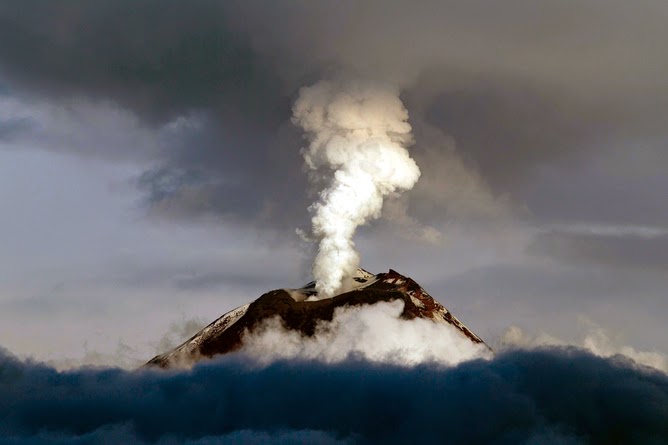
Tungurahua volcano eruption. Credit: © Sunshine Pics / Fotolia

In the typical textbook picture, volcanoes, such as those that are forming the Hawaiian islands, erupt when magma gushes out as narrow jets from deep inside Earth. But that picture is wrong, according to a new study from researchers at Caltech and the University of Miami in Florida.
New seismology data are now confirming that such narrow jets don’t actually exist, says Don Anderson, the Eleanor and John R. McMillian Professor of Geophysics, Emeritus, at Caltech. In fact, he adds, basic physics doesn’t support the presence of these jets, called mantle plumes, and the new results corroborate those fundamental ideas.

“Mantle plumes have never had a sound physical or logical basis,” Anderson says. “They are akin to Rudyard Kipling’s ‘Just So Stories’ about how giraffes got their long necks.”

Anderson and James Natland, a professor emeritus of marine geology and geophysics at the University of Miami, describe their analysis online in the September 8 issue of the Proceedings of the National Academy of Sciences.

According to current mantle-plume theory, Anderson explains, heat from Earth’s core somehow generates narrow jets of hot magma that gush through the mantle and to the surface. The jets act as pipes that transfer heat from the core, and how exactly they’re created isn’t clear, he says. But they have been assumed to exist, originating near where Earth’s core meets the mantle, almost 3,000 kilometers underground — nearly halfway to the planet’s center. The jets are theorized to be no more than about 300 kilometers wide, and when they reach the surface, they produce hot spots.

While the top of the mantle is a sort of fluid sludge, the uppermost layer is rigid rock, broken up into plates that float on the magma-bearing layers. Magma from the mantle beneath the plates bursts through the plate to create volcanoes. As the plates drift across the hot spots, a chain of volcanoes forms — such as the island chains of Hawaii and Samoa.

“Much of solid-Earth science for the past 20 years — and large amounts of money — have been spent looking for elusive narrow mantle plumes that wind their way upward through the mantle,” Anderson says.

To look for the hypothetical plumes, researchers analyze global seismic activity. Everything from big quakes to tiny tremors sends seismic waves echoing through Earth’s interior. The type of material that the waves pass through influences the properties of those waves, such as their speeds. By measuring those waves using hundreds of seismic stations installed on the surface, near places such as Hawaii, Iceland, and Yellowstone National Park, researchers can deduce whether there are narrow mantle plumes or whether volcanoes are simply created from magma that’s absorbed in the sponge-like shallower mantle.

No one has been able to detect the predicted narrow plumes, although the evidence has not been conclusive. The jets could have simply been too thin to be seen, Anderson says. Very broad features beneath the surface have been interpreted as plumes or super-plumes, but, still, they’re far too wide to be considered narrow jets.

But now, thanks in part to more seismic stations spaced closer together and improved theory, analysis of the planet’s seismology is good enough to confirm that there are no narrow mantle plumes, Anderson and Natland say. Instead, data reveal that there are large, slow, upward-moving chunks of mantle a thousand kilometers wide.

In the mantle-plume theory, Anderson explains, the heat that is transferred upward via jets is balanced by the slower downward motion of cooled, broad, uniform chunks of mantle. The behavior is similar to that of a lava lamp, in which blobs of wax are heated from below and then rise before cooling and falling. But a fundamental problem with this picture is that lava lamps require electricity, he says, and that is an outside energy source that an isolated planet like Earth does not have.

The new measurements suggest that what is really happening is just the opposite: Instead of narrow jets, there are broad upwellings, which are balanced by narrow channels of sinking material called slabs. What is driving this motion is not heat from the core, but cooling at Earth’s surface. In fact, Anderson says, the behavior is the regular mantle convection first proposed more than a century ago by Lord Kelvin. When material in the planet’s crust cools, it sinks, displacing material deeper in the mantle and forcing it upward.

“What’s new is incredibly simple: upwellings in the mantle are thousands of kilometers across,” Anderson says. The formation of volcanoes then follows from plate tectonics — the theory of how Earth’s plates move and behave. Magma, which is less dense than the surrounding mantle, rises until it reaches the bottom of the plates or fissures that run through them. Stresses in the plates, cracks, and other tectonic forces can squeeze the magma out, like how water is squeezed out of a sponge. That magma then erupts out of the surface as volcanoes. The magma comes from within the upper 200 kilometers of the mantle and not thousands of kilometers deep, as the mantle-plume theory suggests.

“This is a simple demonstration that volcanoes are the result of normal broad-scale convection and plate tectonics,” Anderson says. He calls this theory “top-down tectonics,” based on Kelvin’s initial principles of mantle convection. In this picture, the engine behind Earth’s interior processes is not heat from the core but cooling at the planet’s surface. This cooling and plate tectonics drives mantle convection, the cooling of the core, and Earth’s magnetic field. Volcanoes and cracks in the plate are simply side effects.

The results also have an important consequence for rock compositions — notably the ratios of certain isotopes, Natland says. According to the mantle-plume idea, the measured compositions derive from the mixing of material from reservoirs separated by thousands of kilometers in the upper and lower mantle. But if there are no mantle plumes, then all of that mixing must have happened within the upwellings and nearby mantle in Earth’s top 1,000 kilometers.

The paper is titled “Mantle updrafts and mechanisms of oceanic volcanism.”

Note : The above story is based on materials provided by California Institute of Technology. The original article was written by Marcus Woo.

New species of extinct dolphin sheds light on river dolphin history

Here are photos of the skull of the new squalodelphinid species Huaridelphis raimondii in dorsal and lateral view. Credit: © G. Bianucci

The unusual river dolphins, some of them known for their poor eyesight and side-swimming behavior are all descendants of ocean-dwelling species. Until now, however, there has been no consensus about their relationships, and few specimens to help illuminate them. In the new issue of the Journal of Vertebrate Paleontology, researchers describe a new fossil dolphin species from the Miocene (dating to more than 16 mya) of the Pisco Basin, a desert on the coast of Peru. It belongs to a rare extinct family of marine dolphins, the squalodelphinids, which are related to the endangered Ganges and Indus river dolphins living today. The new specimens increase the known diversity of squalodelphinids and help shed light on their relationships.

River dolphins are a bizarre group of cetaceans (marine mammals) in that they reside in freshwater rivers and estuaries, though their ancestors were marine. As a result of life in muddy river water, some are functionally blind and have very small dorsal fins. Despite similar appearances, the South Asian river dolphins of the Ganges and Indus rivers (Platanista spp.) are only distantly related to other river dolphins of the Amazon and Yangtze rivers.

The new species, named Huaridelphis raimondii, after the Huari culture (500-1000 AD) the smallest species of its family yet known, has been described from several well-preserved fossils. “The quality of the fossils places these specimens as some of the best-preserved members of this rare family,” says Olivier Lambert, of the Institut Royal des Sciences Naturelles de Belgique, lead author of the study.

Though the squalodelphinids have been known for some time, these small to medium size dolphins are rare in the fossil record, and were until now only found in a few localities (Argentina, France, Italy, and east coast of U.S.A.).

The Pisco Basin, is currently one of the richest areas in the world for the study of the evolution of whales and other marine mammals; whales with fossilized baleen, a giant raptorial sperm whale, and a walrus-like dolphin have been discovered there. According to Dr. Lambert, “For the past 30 years, many fossil cetacean species were described based on material from the Pisco Basin, dated from the Eocene to the Pliocene. And we are still far from the end of the study for this hot spot of marine mammal paleontology.”

Recent fieldwork by the Peruvian paleontologist Mario Urbina and his team in new localities from the early Miocene (23-16 million years ago) lead to the discovery of several well-preserved squalodelphinid skulls, now curated at the Museo de Historia Natural (Lima). Their analysis by Lambert and colleagues lead to the description of the new species.

“Considering the richness of the fossil localities recently discovered, other new extinct dolphins from the same geological age will certainly soon be found and studied,” added Giovanni Bianucci, of the Universitá degli Studi di Pisa and an author on the study.

Note : The above story is based on materials provided by Society of Vertebrate Paleontology.

Shift in Arabia sea plankton may threaten fisheries

Winter blooms of Noctiluca are so vast they can be seen from space. Credit: Norman Kuring, NASA

A growing “dead zone” in the middle of the Arabian Sea has allowed plankton uniquely suited to low- oxygen water to take over the base of the food chain. Their rise to dominance over the last decade could be disastrous for the predator fish that sustain 120 million people living on the sea’s edge.
Scientists at Columbia University’s Lamont-Doherty Earth Observatory and their colleagues are the first to document the rapid rise of green Noctiluca scintillans, an unusual dinoflagellate that eats other plankton and draws energy from the sun via microscopic algae living within its cells. Noctiluca’s thick blooms color the Arabian Sea an emerald green each winter, from the shores of Oman on the west, to India and Pakistan on the east.

In a study published this week in Nature Communications, the researchers show how the millions of green algae living within Noctiluca’s cells allow it to exploit an oxygen-starved dead zone the size of Texas. They hypothesize that a tide of nutrient-rich sewage flowing from booming cities on the Arabian Sea is expanding the dead zone and feeding Noctiluca’s growth.

“These blooms are massive, appear year after year, and could be devastating to the Arabian Sea ecosystem over the long-term,” said the study’s lead author, Helga do Rosario Gomes, a biogeochemist at Lamont-Doherty.

Until recently, photosynthetic diatoms supported the Arabian Sea food chain. Zooplankton grazed on the diatoms, a type of algae, and were in turn eaten by fish. In the early 2000s, it all changed. The researchers began to see vast blooms of Noctiluca and a steep drop in diatoms and dissolved oxygen in the water column. Within a decade, Noctiluca had virtually replaced diatoms at the base of the food chain, marking the start of a colossal ecosystem shift.

Green Noctiluca lives in the tropics while its close relative, red Noctiluca scintillans, whose blooms can sometimes kill fish with their high ammonia content, prefers temperate waters. Green Noctiluca is remarkably willing to eat anything. It feeds on other plankton, living or dead, flushing diatoms and other plankton into its gullet with a flick of its flagellum. It also draws energy from the millions of green algae, or “endosymbionts,” living within its transparent cell walls. The algae fix carbon from sunlight and pass the energy, like rent, on to their host.

A varied diet gives Noctiluca its edge. “They can swim down to find nutrients, up to find light, and they can eat other small organisms,” said Sharon Smith, a plankton ecologist at the University of Miami who works in the Arabian Sea but was not involved in the study.

To understand the key to Noctiluca’s success, the researchers spent three successive winters aboard the Indian research ship Sagar Sampada, starting in 2009. Sailing off the coast of Goa, they sampled blooms and performed experiments.Putting Noctiluca and itsdiatom competitors in oxygen-starved water they found that Noctiluca’s carbon-fixation rate rose by up to 300 percent while the diatoms’ fell by nearly as much. They also found Noctiluca grew faster in light than in dark, thanks to its sun-loving endosymbiont-algae, which are thought to have evolved 1.3 billion years ago on an oxygen-scarce Earth.

The researchers tried to also identify Noctiluca’s predators. They had heard reports of Omani fishermen seeing more gelatinoussalps, jellyfish and sea turtles. Could they be eating the Noctiluca? Scooping up several salps from the sea, the researchers dropped them into buckets of seawater thick with Noctiluca blooms. In an hour, the water became visibly clearer. By measuring the drop in chlorophyll, the researchers estimated that one salp can polish off about two-thirds of a bucket of Noctiluca in an hour.

“They chowed on Noctiluca, like rabbits in a lettuce patch,” said Gomes. “This is a creature that few other marine animals want to eat.”

Noctiluca is too big for the crustacean grazers that normally feed on diatoms, leading to concerns that it could spawn an alternate food chain lacking the predator fish people like to eat. Many fisheries in the Arabian Sea are already on a slow decline. Eighty-five percent of fishermen surveyed in the fishing-dependent states of Tamil Nadu and Maharashtra in Indiareported a smaller catch from 20 years and 12 years earlier, according to a 2014 study in the journal Oryx. Similarly, a rise in puffer fish off the coast of the Indian state of Kerala has been attributed to a crash in predator cobia fish since 2007, according to a 2013 study in Current Science. In Oman, the catch of large fish fell 18 percent in 2013 from the year before, the Times of Oman reported.

Whether Noctiluca or overfishing is to blame, one major factor stands out: massive sewage flows into the Arabian Sea as the coastal population has exploded. As the study authors point out, Mumbai’s population has doubled to 21 million in the last decade. The region now sends 63 tons of nitrogen and 11 tons of phosphorus into the Arabian Sea each day. Karachi’s 15 million people send 70 percent of their wastewater into the sea untreated. Much of the fertilizer used to boost yields on farms in South Asia also eventually washes into rivers that drain into the sea.

“All of these cities are growing so rapidly they don’t have the capacity to treat their sewage,” said study coauthor Joaquim Goes, a biogeochemist at Lamont-Doherty. “The amount of material being discharged is humongous.”

From the Gulf of Mexico to Chesapeake Bay, dead zones and degraded fisheries are on the rise globally. Doubling in size each decade, and now covering more than 95,000 square miles, they are “probably a key stressor on marine ecosystems,” according to a 2008 study in Science. Shifting ocean currents due to climate change can make the problem worse by dredging up nutrients from the ocean bottom.

In the Arabian Sea, stronger summer monsoon winds have boosted algae growth by bringing more nutrients from the deep ocean to the surface. In a 2005 study in Science, Goes, Gomes and colleagues showed that biomass from summer blooms off Somalia, Yemen and Oman, jumped nearly 350 percent between 1997 and 2004. They hypothesize that receding snow cover in the Himalaya-Tibetan plateau is making the Indian subcontinent hotter in summer compared to the Arabian Sea, strengthening the winds that blow toward India, bringing up more nutrients off Somalia, Yemen and Oman.

The researchers expected gentler monsoon winds in winter, as the process reversed itself, leading to fewer algae blooms. But NASA satellite maps showed just the opposite: more winter blooms. After several years of sampling what they thought were sporadic Noctiluca blooms, the researchers realized in 2006 that the blooms seen from space were not diatoms but recurring Noctiluca blooms.

They wondered if falling oxygen levels could explain the diatom-to-Noctiluca shift. Sure enough, the experiments aboard theSagar Sampada seemed toconfirm their hypothesis.

The study has attributed much of Noctiluca’s rise to growing sewage flows into the Arabian Sea, an intriguing connection that should be followed up on, says Andrew Juhl, a microbiologist at Lamont-Doherty who was not involved in the study. “It’s unusual for Noctiluca to bloom in the open sea and return year after year,” he said “All of these observations suggest that something dramatic has changed in the Arabian Sea.”

Note : The above story is based on materials provided by The Earth Institute at Columbia University.

Modeling sulfur in the Archean atmosphere

Was this what Earth looked like during the Archean eon? Image Credit: Peter Sawyer / Smithsonian Institution

A new study has revealed details about the composition of Earth’s atmosphere during the Archean eon, which lasted from around 4 billion years ago to 2.4 billion years ago.
Astrobiologists study the Archean in order to better understand the early evolution of life on Earth, and how organisms survived in an environment that was much different than the planet today. Studying the Archean Earth can also provide clues about life’s potential beyond our planet.

“The Archean Earth is the most habitable planet for which we have data, so studying it is one of the best ways we have of studying alien planets,” said Shawn Domagal-Goldman of NASA’s Goddard Space Flight Center, and co-author on the paper.

Piecing Together the Past

Much of what we know about the Archean environment comes from the geologic record. The oldest known sedimentary rocks on Earth originate from the Archean, and by studying the composition of ancient rocks, astrobiologists are able to piece together the environmental conditions that were present on Earth when the rocks were formed. Before now, they thought the Archean atmosphere contained little to no oxygen, but were much more uncertain about other aspects of the atmosphere. The new study delves deeper into the question of what the Archean environment was like by looking at the amounts of other components in Archean rocks – namely sulfur.

Wrinkle mats at the Dresser Formation (Pilbara region of Australia). Sulfate has been identified in samples from the 3.48 billion year old Dresser Formation. Credit: Wikicommons

Rocks from the Archean contain sulfur compounds, and the sulfur contained in these compounds was deposited from the atmosphere. The types and quantity of sulfur-containing compounds, and the amount of different sulfur isotopes they contain, is a strongly related to atmospheric composition.

Over the years, geologists have made tremendous progress in measuring this isotopic signal in the rock record to help explain conditions in the ancient atmosphere. However, until now, models were incapable of simulating this process with a high degree of precision, and this limited the ability to accurately interpret these records.

This led to a new methodology that could provide greater details about the chemistry of the Archean atmosphere beyond the lack of oxygen. Importantly, this method provides a starting point for additional research on the problem, and could lead to further laboratory studies that will help place constraints on the exact makeup of Earth’s ancient atmosphere.

A New Look at Old Sulfur

In a study supported by the NASA Astrobiology Institute (NAI), scientists describe this new model for the formation of sulfur isotopes in the laboratory (specifically the isotopes known as Δ33S and Δ36S). They used the model to study how these isotopes could have been formed, and the quantity that resulted from each of the formation methods. The levels of isotopes from each method were then compared to the deposition of sulfur seen today in the geologic record.

In simple terms, the team tried to connect the way sulfur isotopes were formed with the sulfur signal that now exists in rocks from the Archean.

The results show that there are problems with previously-proposed pathways for sulfur isotope formation, because the numbers just don’t match up. The model’s predictions of sulfur and isotope content in the rocks result in significant disagreements with what is observed in the ancient rocks. This could be resolved by further laboratory work that will improve the inputs to the models, or by new theories on how biology acted on the sulfur after it left the atmosphere but before it was preserved in rocks.

“The model development done by Mark Claire [lead author] for this paper will significantly improve our ability to predict, and eventually understand, the sulfur isotope record of ancient Earth,” explained Domagal-Goldman.

More information:
Mark W. Claire, James F. Kasting, Shawn D. Domagal-Goldman, Eva E. Stüeken, Roger Buick, Victoria S. Meadows, “Modeling the signature of sulfur mass-independent fractionation produced in the Archean atmosphere,” Geochimica et Cosmochimica Acta, Volume 141, 15 September 2014, Pages 365-380, ISSN 0016-7037, dx.doi.org/10.1016/j.gca.2014.06.032.

Note : The above story is based on materials provided by Astrobio.net
This story is republished courtesy of NASA’s Astrobiology Magazine.

New solutions needed to recycle fracking water

Rice University researchers performed a detailed analysis of “produced” water from three underground shale gas formations subject to hydraulic fracturing. The chart shows the amounts of total carbon (TC), nonpurgeable organic carbon (NPOC) and total inorganic carbon (TIC) in the samples. (Credit: Barron Research Group/Rice University)

HOUSTON – (Aug. 27, 2014) – Rice University scientists have performed a detailed analysis of water produced by hydraulic fracturing (aka fracking) of three gas reservoirs and suggested environmentally friendly remedies are needed to treat and reuse it.
Rice University researchers performed a detailed analysis of “produced” water from three underground shale gas formations subject to hydraulic fracturing. The chart shows the amounts of total carbon (TC), nonpurgeable organic carbon (NPOC) and total inorganic carbon (TIC) in the samples. Courtesy of the Barron Research Group

More advanced recycling rather than disposal of “produced” water pumped back out of wells could calm fears of accidental spillage and save millions of gallons of fresh water a year, said Rice chemist Andrew Barron. He led the study that appeared this week in the Royal Society of Chemistry journal Environmental Science: Processes and Impacts.

The amount of water used by Texas drillers for fracking may only be 1.5 percent of that used by farming and municipalities, but it still amounts to as much as 5.6 million gallons a year for the Texas portion of the Haynesville formation and 2.8 million gallons for Eagle Ford. That, Barron said, can place a considerable burden on nearby communities.

Barron noted that shale gas wells, the focus of the new study, make most of their water within the first few weeks of production. After that, a few barrels a day are commonly produced.

The project began with chemical analysis of fracking fluids pumped through gas-producing shale formations in Texas, Pennsylvania and New Mexico. Barron and the study’s lead author, Rice alumnus Samuel Maguire-Boyle, found that shale oil and gas-produced water does not contain significant amounts of the polyaromatic hydrocarbons that could pose health hazards; but minute amounts of other chemical compounds led them to believe the industry would be wise to focus its efforts on developing nonchemical treatments for fracking and produced water.

Currently, fracturing fluid pumped into a well bore to loosen gas and oil from shale is either directed toward closed fluid-capture systems when it comes out or is sent back into the ground for storage. But neither strategy is an effective long-term solution, Barron said.

“Ultimately, it will be necessary to clean produced water for reuse in fracking,” he said. “In addition, there is the potential to recover the fraction of hydrocarbon in the produced water.”

Fracking fluid is 90 percent water, Barron said. Eight to nine percent of the fluid contains sand or ceramic proppant particles that wedge themselves into tiny fractures in the rock, holding open paths for gas and oil to escape to the production well.

The remaining 1 or 2 percent, however, may contain salts, friction reducers, scale inhibitors, biocides, gelling agents, gel breakers and organic and inorganic acids. The organic molecules either occur naturally or are a residue from the added components.

The researchers found most of the salt, organic and other minerals that appear in produced water from shale gas reservoirs originate in the connate waters trapped in the dense rock over geologic time scales. These should be of little concern, they wrote

But they also found that produced water contained potentially toxic chlorocarbons and organobromides, probably formed from interactions between high levels of bacteria in the water and salts or chemical treatments used in fracking fluids.

Barron said industry sometimes uses chlorine dioxide or hypochlorite treatments to recycle produced water for reuse, but these treatments can actually enhance bacteria’s ability to convert naturally occurring hydrocarbons to chlorocarbons and organobromides. The researchers suggested this transition could happen either downhole or in storage ponds where produced water is treated.

“We believe the industry needs to investigate alternative, nonchemical treatments to avoid the formation of compounds that don’t occur in nature,” Barron said.

Primarily, he said, the researchers want their analysis to anticipate future problems as industry develops processes to remove organic compounds from water bound for reuse.

Barron said the new paper should be of particular interest to international producers who are preparing to ramp up gas-recovery efforts in the United Kingdom, which recently announced plans to expand drilling, and other European countries.

“As the U.K. and other European countries are looking to start hydraulic fracturing, it is important that they adopt best practices at the start, as opposed to evolving over time, as it has occurred here in the United States,” he said.

The Robert A. Welch Foundation and the Welsh Government Sêr Cymru Program funded the research. Barron is Rice’s Charles W. Duncan Jr.–Welch Professor of Chemistry and a professor of materials science and nanoengineering.

Note : The above story is based on materials provided by Copyright Rice University News & Media

Scientists obtain new data on the weather 10.000 years ago from sediments at the bottom of a lake in Sierra Nevada

University of Granada researchers collecting samples in an Alpine lake in Sierra Nevada (Granada)

Researchers at the University of Granada participate in an international project which has revealed that during the early phase of the Holocene (10.000 – 6.000 years ago) the climate in the Iberian Peninsula was rather more humid than it currently is.Scientists have found evidence of atmospheric dust from the Sahara in the depths of the Rio Seco lake, 3.020 meters above sea level, accumulated over the last 11.000 years.

A research project which counts with the participation of the University of Granada has revealed new data on the climate change that took place in the Iberian Peninsula around the mid Holocene (around 6.000 years ago), when the amount of atmospheric dust coming from the Sahara increased. The data came from a study of the sediments found in an Alpine lake in Sierra Nevada (Granada)

This study, published in the journal Chemical Geology, is based on the sedimentation of atmospheric dust from the Sahara, a very frequent phenomenon in the South of the Iberian Peninsula. This phenomenon is easily identified currently, for instance, when a thin layer of red dust can be occasionally found on vehicles.

Scientists have studied an Alpine lake in Sierra Nevada, 3020 metres above sea level, called Rio Seco lake. They collected samples from sediments 1,5 metres deep, which represent approximately the last 11.000 years (a period known as Holocene), and they found, among other paleoclimate indicators, evidence of atmospheric dust coming from the Sahara. According to one of the researchers in this study, Antonio García-Alix Daroca, from the University of Granada, “the sedimentation of this atmospheric dust over the course of the Holocene has affected the vital cycles of the lakes in Sierra Nevada, since such dust contains a variety of nutrients and / or minerals which do not abound at such heights and which are required by certain organisms which dwell there”

More atmospheric dust from the Sahara

This study has also revealed the existence of a relatively humid period during the early phase of the Holocene (10.000 – 6.000 years approximately). This period witnessed the onset of an aridification tendency which has lasted until our days, and it has coincided with an increase in the fall of atmospheric dust in the South of the Ibeian Peninsula, as a result of African dust storms.

“We have also detected certain climate cycles ultimately related to solar causes or the North Atlantic Oscillacion (NAO)”, according to García-Alix. “Since we do not have direct indicators of these climate and environmental changes, such as humidity and temperature data, in order to conduct this research we have resorted to indirect indicators, such as fossil polen, carbons and organic and inorganic geochemistry within the sediments”.

This research has been conducted as part of several projects which count with the participation of scientists at the University of Granada, the Andalusian Institute of Earth Sciences (CSIC-UGR), the University of Murcia, the University of Glasgow, and the University of Northern Arizona.

Note : The above story is based on materials provided by University of Granada

Snails Tell of the Rise and Fall of the Tibetan Plateau

The Tibetan Plateau. Image courtesy NASA.

Boulder, Colo., USA – The rise of the Tibetan plateau — the largest topographic anomaly above sea level on Earth — is important for both its profound effect on climate and its reflection of continental dynamics. In this study published in GSA Bulletin, Katharine Huntington and colleagues employ a cutting-edge geochemical tool — “clumped” isotope thermometry — using modern and fossil snail shells to investigate the uplift history of the Zhada basin in southwestern Tibet.

Views range widely on the timing of surface uplift of the Tibetan Plateau to its current high (~4.5 km) over more than 2.5 square kilometers. Specifically, interpretations differ on whether the modern high elevations were recently developed or are largely a continuation of high elevations developed prior to Indo-Asian collision in the Eocene.

Clumped isotope temperatures of modern and fossil snail shells record changing lake water temperatures over the last nine million years. This is a reflection of changes in surface temperature as a function of climate and elevation change. A key to their Zhada Basin paleo-elevation reconstructions is that Huntington and colleagues were able to contextualize them with sampling of modern and Holocene-age tufa and shells from a range of aquatic environments.

Huntington and colleagues find that the Zhada basin was significantly colder from three to nine million years ago, implying a loss of elevation of more than one kilometer since the Pliocene. While surprising given the extreme (~4 km) elevation of the basin today, the higher paleo-elevation helps explain paleontological evidence of cold-adapted mammals living in a high-elevation climate, and is probably the local expression of east-west extension across much of the southern Tibetan Plateau at this time.

Huntington and colleagues note that future studies could improve on their own initial “calibration” work with year-round monitoring of water temperature and a focus on specific taxa and their micro-habitat preferences.

Map:

More Information :
K.W. Huntington et al., Dept. of Earth and Space Sciences, University of Washington, Seattle, Washington 98195, USA. Published online 7 Aug. 2014; http://dx.doi.org/10.1130/B31000.1

Note : The above story is based on materials provided by The Geological Society of America, Inc.

Related Articles