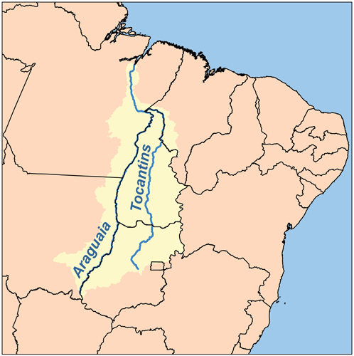
The Araguaia River is one of the major rivers of Brazil, and the principal tributary of the Tocantins, though it is almost equal in volume at its confluence with the Tocantins. It has a total length of approximately 2,627 km. Araguaia means “river of (red) macaws” in the Tupi language.
Geography
Because of the vast number of tributaries, it is not easy to define its source. Important tributaries originate in the Araras mountain range in Mato Grosso as well in the Divisões mountain range situated in Goiás (according to other sources however, the Araguaia comes from the Caiapó Range, at the Goiás-Mato Grosso border). From there it flows northeast to a junction with the Tocantins near the town of São João.
Along its course, the river forms the border between the Brazilian federal states of Goiás, Mato Grosso, Tocantins and Pará. Roughly in the middle of its course, the Araguaia splits into two forks (with the western one retaining the name Araguaia and the eastern one being called Rio Javaés). These later reunite, forming the Ilha do Bananal, the world’s largest river island. The mouth of the Javaés forms a broad inland delta where it pours back into the main Araguaia, a 100,000 hectare expanse of igapó flooded forest, blackwater river channels, and oxbow lakes called Cantão. This is one of the biologically richest areas of the eastern Amazon, with over 700 species of birds, nearly 300 species of fish, large populations of threatened species such as the giant otter, the black cayman, the world’s largest freshwater fish, the pirarucú, and the endemic Araguaian river dolphin (or Araguaian boto) all occurring within a relatively small area.
A large portion of the Araguaia’s course is navigable all year, but the river below the Cantão wetlands is interrupted by rapids.
The combined watershed of Araguaia and Tocantins rivers (named the Araguaia Tocantins Basin) covers approximately 9.5% of Brazil’s national territory. This area is an integral part of the Amazon Basin. However, the Araguaia River is not a tributary of the Amazon.
“Araguaia” means “River of the Macaws” in the native Tupi language.
Tributaries
Its principal tributary is the Rio das Mortes, which rises in the Serra de São Jerônimo, near Cuiabá, Mato Grosso, and is navigable to Pará.
Other important tributaries include the Bonito, Garcas, Cristallino and Tapirape on the west, and the Pitombas, Claro, Vermelho, Tucupa and Chavante on the east.
Note : The above story is based on materials provided by Wikipedia.
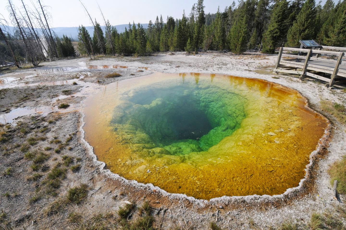
This is a photograph of Morning Glory Pool from Aug. 23, 2012. Credit: Joseph Shaw, Montana State University
Researchers at Montana State University and Brandenburg University of Applied Sciences in Germany have created a simple mathematical model based on optical measurements that explains the stunning colors of Yellowstone National Park’s hot springs and can visually recreate how they appeared years ago, before decades of tourists contaminated the pools with make-a-wish coins and other detritus.
The model, and stunning pictures of the springs, appear today in the journal Applied Optics, which is published by The Optical Society (OSA).
If Yellowstone National Park is a geothermal wonderland, Grand Prismatic Spring and its neighbors are the ebullient envoys, steaming in front of the camera and gracing the Internet with their ethereal beauty. While the basic physical phenomena that render these colorful delights have long been scientifically understood — they arise because of a complicated interplay of underwater vents and lawns of bacteria — no mathematical model existed that showed empirically how the physical and chemical variables of a pool relate to their optical factors and coalesce in the unique, stunning fashion that they do.
“What we were able to show is that you really don’t have to get terribly complex – you can explain some very beautiful things with relatively simple models,” said Joseph Shaw, a professor at Montana State University and director of the university’s Optical Technology Center. Shaw, along with his Ph.D. student Paul Nugent and German colleague Michael Vollmer, co-authored the new paper.
Using a relatively simple one-dimensional model for light propagation, the group was able to reproduce the brilliant colors and optical characteristics of Yellowstone National Park’s hot springs by accounting for each pool’s spectral reflection due to microbial mats, their optical absorption and scattering of water and the incident solar and diffuse skylight conditions present when measurements were taken.
“When we started the study, it was clear we were just doing it for fun,” Vollmer said. But they quickly discovered there was very little in the scientific literature on the subject. That’s when things got interesting.
Montana State University, in Bozeman, Mont., is a short drive away from Yellowstone National Park. In the summer of 2012, Vollmer, on sabbatical from the Brandenburg University of Applied Sciences, travelled with Shaw and Nugent to the park. Using handheld spectrometers, digital SLR cameras for visible images and long wave infrared thermal imaging cameras for non-contact measurement of the water temperatures, the group took measurements at a number of pools in Yellowstone, including Morning Glory Pool, Sapphire Pool and Grand Prismatic Spring. Using these data, along with previously available information about the physical dimensions of the pools, they were able to create a simple model whose renderings of the pools were strikingly similar to actual photographs.
In the case of Morning Glory Pool, they were even able to simulate what the pool once looked like between the 1880s and 1940s, when its temperatures were significantly higher. During this time, its waters appeared a uniform deep blue. An accumulation of coins, trash and rocks over the intervening decades has partially obscured the underwater vent, lowering the pool’s overall temperature and shifting its appearance to a terrace of orange-yellow-green. This change from blue was demonstrated to result from the change in composition of the microbial mats, as a result of the lower water temperature.
A general relationship between shallow water temperature (hence microbial mat composition) and observed colors was confirmed in this study. However, color patterns observed in deeper segments of the pool are caused more by absorption and scattering of light in the water. These characteristics – mats having greater effect on color in shallow water, and absorption and scattering winning out in the deeper areas – are consistent across all the measured pools.
“Our paper describes a very simple, 1-dimensional model, that gives the first clue if you really want to do more,” Vollmer said.
“We didn’t start this project as experts on thermal pools,” Shaw said. “We started this project as experts on optical phenomena and imaging, and so we had a lot to learn.”
“There are people at my university who are world experts in the biological side of what’s going on in the pools,” Shaw said. “They’re looking for ways to monitor changes in the biology – when the biology changes, that causes color changes – so we’re actually looking at possibilities of collaborating in the future.”
Future work for Nugent, Vollmer and Shaw includes delving further into infrared imaging at Yellowstone National Park.
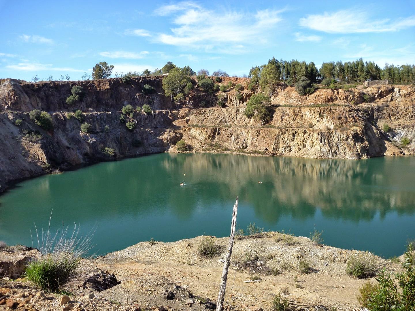
This is the pit Lake Guadiana in the former mining area Herrerias in Andalusia, Spain. Credit: Photo: Bertram Boehrer/UFZ
Puebla del Guzman (Andalusia) / Magdeburg. Being part of the mining area Herrerias in Andalusia, deep waters of Pit Lake Guadiana show extremely high concentration of dissolved carbon dioxide (CO2). In the case of a spontaneous ebullition, human beings close-by would be jeopardized.
To demonstrate the danger and the possible solution, scientists of the Spanish Institute of Geology and Mining, the University of the Basque Country (UPV/EHU, Bilbao) and the Helmholtz Centre for Environmental Research (UFZ) constructed a pilot plant for degassing. A fountain pulls deep water through a pipe to the surface, where the gas can escape from the water. The buoyancy produced by the bubbles provides the energy required for driving the flow.
„The deep water in the residual lake Guadiana contains an extremely high volume of carbon dioxide (CO2). Oxidation of ores has created a very acidic milieu, which is also known from other mining areas. In the mining area Herrerias however, this acidity dissolves carbonate from the rocks and produces carbonic acid (dissolved CO2), which can be accumulated under the high pressures of deep waters in the lake. There is not much circulation beyond 25 meter depth to remove the gas load” says Dr. Bertram Boehrer of UFZ, who is physicist and has been investigating stratification in lakes at many places on Earth. Due to the high hydrostatic pressure, each liter of deep water contains about 2.5 liters of CO2 gas. As long as the stratification remains stable, the gas is retained in the deep water. A land slide or other processes producing large water movements could facilitate a sudden release of gas previously confined under high pressure. Inhaled air of 8 percent CO2 are considered deadly for humans.
Now the scientists installed a degasing pipe which is the heart of the new pilot plant: Deep water enters a pipe at 61m depth. On the way up, hydrostatic pressure drops and gas bubbles form. The reduced density of the water-gas-mixture allows that deep water is pushed out of the pipe at the upper end to form a fountain above the water table, where gas is released to the atmosphere. This is an elegant solution, as the system does not require any additional driver, and the controlled release of CO2 does not pose any problem. „With this pilot plant, we could demonstrate that this approach also works in Guadiana pit lake. This can now be proposed to authorities as a possible approach to deal with the gas load.” Though the lake in the mining area is fenced and access is not permitted to the public, this prohibition is difficult to survey.
Earlier installations in Lake Nyos in Cameroon served as a good example for this approach. In this lake, degassing pipes had been installed, which released the gas load with three fountains. On August 21st 1986, a large volume of gas escaped from the lake suddenly. The gas entered valleys of the surrounding area. 1700 human beings and thousands of animals were killed. The trigger could have been a land slide though this was never really proven. To avoid a repetition of this disaster, the gas load is slowly removed from the lake. One more crater lake called Monoun in Cameroon suffocated 37 human beings close to its shores in a similar eruption. Also in Monoun degasing fountains have been installed.
In Guadiana pit lake we do not see the same danger as in Lake Nyos, due to smaller size and depth. In addition, a density gradient between surface waters and deep waters is keeping the system stable. However, gas concentrations are so high that precaution must be taken. More detailed investigations must be implemented and remediation must be considered, says Dr. Boehrer. For the formation of such extreme gas loads, lakes must be sufficiently deep with incomplete winter recirculation (meromixis) and a strong carbon dioxide source. At the moment, we do not have such a lake in Germany.
University of Pittsburgh researchers have shared their findings from three studies related to shale gas in a recent special issue of the journal Energy Technology, edited by Götz Veser, the Nickolas A. DeCecco Professor of Chemical and Petroleum Engineering in Pitt’s Swanson School of Engineering.
In the special issue focusing on shale gas, Pitt faculty authors look at “smart wells” that use wireless communication, wastewater management, and information gaps between legislators, regulators, industry representatives, researchers, and the public on the health and environmental impacts of shale gas drilling. The issue also includes contributions from experts from across the United States, Europe, and Asia.
Veser, who is on the journal’s editorial board, says, “I saw an opportunity to create visibility for the journal by issuing a special issue on this topic, which has garnered much attention worldwide, and at the same time highlight some of the world-class expertise in this area on our campus as well.”
Pitt faculty members contributed three papers to the issue.
Smart Wells
Andrew Bunger and his co-authors propose the development of a series of sensors sunk into wells that will allow drilling companies to pull data from the deep and use that information to optimize sections of productive wells, ramp up or shut down unproductive sections, and find pockets of gas or oil that have been overlooked.
Bunger, assistant professor of civil and environmental engineering, along with Ervin Sejdić, assistant professor of electrical and computer engineering, Nicholas Franconi, a PhD candidate in electrical and computer engineering, and Marlin Mickle, professor emeritus of electrical and computer engineering, believe academics and industry are poised to improve extraction through wireless communication.
Bunger likens this nascent technology to cell phone communication, with the signal being passed from tower to tower on a call from, say, Pittsburgh to Los Angeles rather than beamed directly over great distance. The stepwise process is necessary, he says, because of the difficulty of sending data long distances through rock and other geological media.
Wastewater Management
Pitt’s Radisav Vidic investigates methods to safely reuse drilling wastewater and ways of removing potentially harmful substances, including naturally occurring radioactive materials, from the wastewater.
Vidic, the William Kepler Whiteford Professor and Chair in the Department of Civil and Environmental Engineering and a nationally recognized expert in water issues related to fracking, reviews the management of wastewater produced during fracking in Pennsylvania’s Marcellus Shale reserve. In this paper, he is joined by co-authors Can He, Tieyuan Zhang, Xuan Zheng, and Yang Li, all of Pitt’s Department of Civil and Environmental Engineering.
Information Gaps
Shanti Gamper-Rabindran examines the gaps in the collection of information–and access to that information–which prevents the public, researchers, regulators, and investors from fully understanding the health and environmental impacts from the shale industry. Resolving these information gaps would enable further innovations in risk-management strategies and, thus, benefit the industry and society.
She is an associate professor in Pitt’s Graduate School of Public and International Affairs and the Department of Economics within the Kenneth P. Dietrich School of Arts and Sciences.
“Informed public debate in the lifecycle of unconventional shale gas development is critical because of the uncertainties in its benefits and risks, the unequal distribution of these benefits and risks in society, and the need to make evidence-based trade-offs between the benefits and costs of risk-mitigation strategies,” Gamper-Rabindran writes.
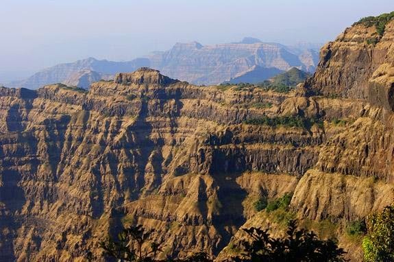
A definitive geological timeline from Princeton University researchers shows that a series of massive eruptions 66 million years ago in a primeval volcanic range in western India known as the Deccan Traps played a role in the extinction event that claimed Earth’s non-avian dinosaurs, and challenges the dominant theory that a meteorite impact was the sole cause of the extinction. Pictured above are the Deccan Traps near Mahabaleshwar, India. Credit: Image courtesy of Gerta Keller, Department of Geosciences
A definitive geological timeline shows that a series of massive volcanic explosions 66 million years ago spewed enormous amounts of climate-altering gases into the atmosphere immediately before and during the extinction event that claimed Earth’s non-avian dinosaurs, according to new research from Princeton University.
A primeval volcanic range in western India known as the Deccan Traps, which were once three times larger than France, began its main phase of eruptions roughly 250,000 years before the Cretaceous-Paleogene, or K-Pg, extinction event, the researchers report in the journal Science. For the next 750,000 years, the volcanoes unleashed more than 1.1 million cubic kilometers (264,000 cubic miles) of lava. The main phase of eruptions comprised about 80-90 percent of the total volume of the Deccan Traps’ lava flow and followed a substantially weaker first phase that began about 1 million years earlier.
The results support the idea that the Deccan Traps played a role in the K-Pg extinction, and challenge the dominant theory that a meteorite impact near present-day Chicxulub, Mexico, was the sole cause of the extinction. The researchers suggest that the Deccan Traps eruptions and the Chicxulub impact need to be considered together when studying and modeling the K-Pg extinction event.
The Deccan Traps’ part in the K-Pg extinction is consistent with the rest of Earth history, explained lead author Blair Schoene, a Princeton assistant professor of geosciences who specializes in geochronology. Four of the five largest extinction events in the last 500 million years coincided with large volcanic eruptions similar to the Deccan Traps. The K-Pg extinction is the only one that coincides with an asteroid impact, he said.
“The precedent is there in Earth history that significant climate change and biotic turnover can result from massive volcanic eruptions, and therefore the effect of the Deccan Traps on late-Cretaceous ecosystems should be considered,” Schoene said.
The researchers used a precise rock-dating technique to narrow significantly the timeline for the start of the main eruption, which until now was only known to have occurred within 1 million years of the K-Pg extinction, Schoene said. The Princeton group will return to India in January to collect more samples with the purpose of further constraining eruption rates during the 750,000-year volcanic episode.
Schoene and his co-authors gauged the age of petrified lava flows known as basalt by comparing the existing ratio of uranium to lead given the known rate at which uranium decays over time. The uranium and lead were found in tiny grains — less than a half-millimeter in size — of the mineral zircon. Zircon is widely considered Earth’s best “time capsule” because it contains a lot of uranium and no lead when it crystallizes, but it is scarce in basalts that cooled quickly. The researchers took the unusual approach of looking for zircon in volcanic ash that had been trapped between lava flows, as well as within thick basalt flows where lava would have cooled more slowly.
The zircon dated from these layers showed that 80-90 percent of the Deccan Traps eruptions occurred in less than a million years, and began very shortly — in geological terms — before the K-Pg extinction. To produce useful models for events such as the K-Pg extinction, scientists want to know the sequence of events to within tens of thousands of years or better, not millions, Schoene said. Margins of millions of years are akin to “a history book with events that have no dates and are not written in chronological order,” he said.
“We need to know which events happened first and how long before other events, such as when did the Deccan eruptions happen in relation to the K-Pg extinction,” Schoene said. “We’re now able to place a higher resolution timeframe on these eruptions and are one step closer to finding out what the individual effects of the Deccan Traps eruptions were relative to the Chicxulub meteorite.”
Vincent Courtillot, a geophysicist and professor at Paris University Diderot, said that the paper is important and “provides a significant improvement on the absolute dating of the Deccan Traps.” Courtillot, who is familiar with the Princeton work but had no role in it, led a team that reported in the Journal of Geophysical Research in 2009 that Deccan volcanism occurred in three phases, the second and largest of which coincides with the K-Pg mass extinction. Numerous other papers from his research groups are considered essential to the development of the Deccan Traps hypothesis. (The Princeton researchers also plan to test the three-phases hypothesis, Schoene said. Their data already suggests that the second and third phase might be a single period of eruptions bridged by smaller, “pulse” eruptions, he said.)
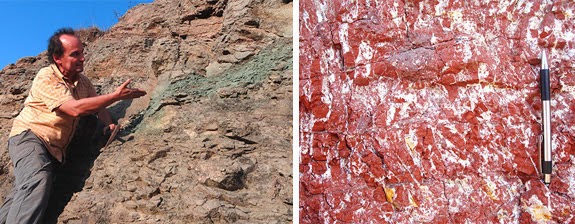
The researchers took an unusual approach to find the mineral needed to construct the timeline for the start of the main Deccan Traps eruption. They compared the existing ratio of uranium to lead in petrified lava flows known as basalts given the known rate at which uranium decays over time. To have enough uranium, however, the researchers needed the mineral zircon, which is scarce in basalts that cooled quickly. Turning to new sources, the researchers found zircon in soil deposits known as red boles (right) that formed in between eruptions and contain volcanic ash (left) that had been trapped between lava flows. They also located zircon within thick basalt flows where lava would have cooled more slowly. (Images courtesy of Blair Schoene, Department of Geosciences)
The latest work builds on the long-time work by co-author Gerta Keller, a Princeton professor of geosciences, to establish the Deccan Traps as a main cause of the K-Pg extinction. Virginia Tech geologist Dewey McLean first championed the theory 30 years ago and Keller has since become a prominent voice among a large group of scientists who advocate the idea. In 2011, Keller published two papers that together proposed a one-two punch of Deccan volcanism and meteorite strikes that ended life for more than half of Earth’s plants and animals.
Existing models of the environmental effects of the Deccan eruptions used timelines two to three times longer than what the researchers found, which underestimated the eruptions’ ecological fallout, Keller explained. The amount of carbon dioxide and sulfur dioxide the volcanoes poured out would have produced, respectively, a long-term warming and short-term cooling of the oceans and land, and resulted in highly acidic bodies of water, she said.
Because these gases dissipate somewhat quickly, however, a timeline of millions of years understates the volcanoes’ environmental repercussions, while a timeframe of hundreds of thousands of years — particularly if the eruptions never truly stopped — provides a stronger correlation. The new work confirms past work by placing the largest Deccan eruptions nearer the K-Pg extinction, but shows a much shorter time frame of just 250,000 years, Keller said.
“These results have significantly strengthened the case for volcanism as the primary cause for the mass extinction, as well as for the observed rapid climate changes and ocean acidification,” Keller said.
“The Deccan Traps mass extinction hypothesis has already enjoyed wide acceptance based on our earlier work and a number of studies have independently confirmed the global effects of Deccan volcanism just prior to the mass extinction,” she said. “The current results will go a long way to strengthen the earlier results as well as further challenge the dominance of the Chicxulub hypothesis.”
Reference:
B. Schoene, K. M. Samperton, M. P. Eddy, G. Keller, T. Adatte, S. A. Bowring, S. F. R. Khadri, B. Gertsch. U-Pb geochronology of the Deccan Traps and relation to the end-Cretaceous mass extinction. Science, 2014; DOI: 10.1126/science.aaa0118
Note : The above story is based on materials provided by Princeton University. The original article was written by Morgan Kelly.
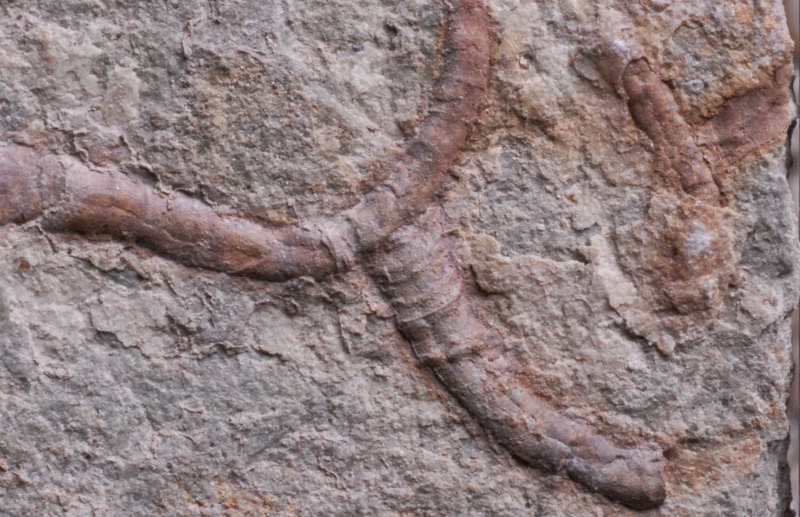
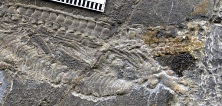
Conotubus. Three-dimensionally pyritized tube-worm like fossils, Conotubus, from the 550 million year old Gaojiashan Lagerstätte, Shaanxi Province, South China. Credit: Yaoping Cai, Northwest University, Xi’an, China.
A new study from University of Missouri and Virginia Tech researchers is challenging accepted ideas about how ancient soft-bodied organisms become part of the fossil record. Findings suggest that bacteria involved in the decay of those organisms play an active role in how fossils are formed — often in a matter of just a few tens to hundreds of years. Understanding the relationship between decay and fossilization will inform future study and help researchers interpret fossils in a new way.
“The vast majority of the fossil record is composed of bones and shells,” said James Schiffbauer, assistant professor of geological sciences in the College of Arts and Science at MU. “Fossils of soft-bodied animals like worms and jellyfish, however, provide our only views onto the early evolution of animal life. Most hypotheses as to the preservation of these soft tissues focus on passive processes, where normal decay is halted or impeded in some way, such as by sealing off the sediments where the animal is buried. Our team is instead detailing a scenario where the actual decay helped ‘feed’ the process turning the organisms into fossils — in this case, the decay of the organisms played an active role in creating fossils.”
Schiffbauer studied a type of fossil animal from the Ediacaran Period called Conotubus, which lived more than 540 million years ago. He noted that these fossils are either replicated by, or associated with, pyrite — commonly called fool’s gold. The tiny fossils are tube-shaped and believed to have been composed of substances similar at least in hardness to human fingernails. These fossilized tubes are all that remain of the soft-bodied animals that inhabited them and most likely resembled worms or sea anemone-like animals.
“Most of the animals that had once lived on the Earth — with estimates eclipsing 10 billion species — were never preserved in the fossil record, but in our study we have a spectacular view of a tinier fraction of soft-bodied animals,” said Shuhai Xiao, professor of geobiology at Virginia Tech and a co-author on this study. “We asked the important questions of how, and under what special conditions, these soft-tissued organisms can escape the fate of complete degradation and be preserved in the rock record.”
Schiffbauer and his team performed a sophisticated suite of chemical analyses of these fossils to determine what caused the pyrite to form. They found that the fool’s gold on the organisms’ outer tube formed when bacteria first began consuming the animal’s soft tissues, with the decay actually promoting the formation of pyrite.
“Normally, the Earth is good at cleaning up after itself,” Schiffbauer said. “In this case, the bacteria that helped break down these organisms also are responsible for preserving them as fossils. As the decay occurred, pyrite began replacing and filling in space within the animal’s exoskeleton, preserving them. Additionally, we found that this process happened in the space of a few years, perhaps even as low as 12 to 800. Ultimately, these new findings will help scientists to gain a better grasp of why these fossils are preserved, and what features represent the fossilization process versus original biology, so we can better reconstruct the evolutionary tree of life.”
Reference:
James D. Schiffbauer, Shuhai Xiao, Yaoping Cai, Adam F. Wallace, Hong Hua, Jerry Hunter, Huifang Xu, Yongbo Peng, Alan J. Kaufman. A unifying model for Neoproterozoic–Palaeozoic exceptional fossil preservation through pyritization and carbonaceous compression. Nature Communications, 2014; 5: 5754 DOI: 10.1038/ncomms6754
The night side of the terrestrial magnetosphere forms a structured magnetotail, consisting of a plasma sheet at low latitudes that is sandwiched between two regions called the magnetotail lobes. The lobes consist of the regions in which Earth’s magnetic field lines are directly connected to the magnetic field carried by the solar wind. Different plasma populations are observed in these regions — plasma in the lobes is very cool, whereas the plasma sheet is more energetic. The diagram labels by two red dots the location of an ESA Cluster satellite and NASA’s IMAGE satellite on 15 September 2005, when particular conditions of the magnetic field configuration gave rise to a phenomenon known as ‘theta aurora.’ Credit: ESA/NASA/SOHO/LASCO/EIT
A University of Southampton researcher has helped solve a long-standing space mystery — the origin of the ‘theta aurora’.
Auroras are the most visible manifestation of the Sun’s effect on Earth. They are seen as colourful displays in the night sky, known as the Northern or Southern Lights. They are caused by the solar wind, a stream of plasma — electrically charged atomic particles — carrying its own magnetic field, interacting with Earth’s magnetic field.
Normally, the main region for this impressive display is the ‘auroral oval’, which lies at around 65-70 degrees north or south of the equator, encircling the polar caps.
However, auroras can occur at even higher latitudes. One type is known as a ‘theta aurora’ because seen from above it looks like the Greek letter theta — an oval with a line crossing through the centre.
While the cause of the auroral oval emissions is reasonably well understood, the origin of the theta aurora was unclear until now.
Researchers observed particles in the two ‘lobe’ regions of the magnetosphere. The plasma in the lobes is normally cold, but previous observations suggested that theta auroras are linked with unusually hot lobe plasma.
Dr Robert Fear from the University of Southampton (formerly at the University of Leicester, where much of the research took place), and lead author of the paper published in Science this week, says: “Previously it was unclear whether this hot plasma was a result of direct solar wind entry through the lobes of the magnetosphere, or if the plasma is somehow related to the plasma sheet on the night side of Earth.
“One idea is that the process of magnetic reconnection on the night side of Earth causes a build-up of ‘trapped’ hot plasma in the higher latitude lobes.”
The mystery was finally solved by studying data collected simultaneously by the European Space Agency’s (ESA) Cluster and NASA’s IMAGE satellites on 15 September 2005. While the four Cluster satellites were located in the southern hemisphere magnetic lobe, IMAGE had a wide-field view of the southern hemisphere aurora. As one Cluster satellite observed uncharacteristically energetic plasma in the lobe, IMAGE saw the ‘arc’ of the theta aurora cross the magnetic footprint of Cluster.
“We found that the energetic plasma signatures occur on high-latitude magnetic field lines that have been ‘closed’ by the process of magnetic reconnection, which then causes the plasma to become relatively hot,” says Dr Fear.
“Because the field lines are closed, the observations are incompatible with direct entry from the solar wind. By testing this and other predictions about the behaviour of the theta aurora, our observations provide strong evidence that the plasma trapping mechanism is responsible for the theta aurora,” he adds.
“The study highlights the intriguing process that can occur in the magnetosphere when the interplanetary magnetic field of the solar wind points northwards,” adds Philippe Escoubet, ESA’s Cluster project scientist.
“This is the first time that the origin of the theta aurora phenomenon has been revealed, and it is thanks to localised measurements from Cluster combined with the wide-field view of IMAGE that we can better understand another aspect of the Sun-Earth connection,” he adds.
Reference:
R. C. Fear, S. E. Milan, R. Maggiolo, A. N. Fazakerley, I. Dandouras, S. B. Mende. Direct observation of closed magnetic flux trapped in the high-latitude magnetosphere. Science, 19 December 2014 DOI: 10.1126/science.1257377
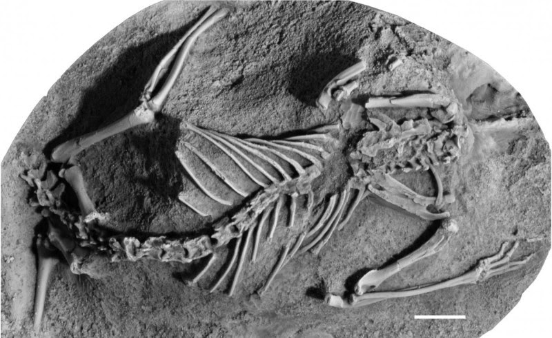
This image shows a cast of the fossil remnants of Asiatherium reshetovi,one of the metatherian species that used to live on the planet millions of years ago. (scale bar: 1cm)Credit: Dr Thomas Williamson; CC-BY 4.0
The extinction of the dinosaurs 66 million years ago is thought to have paved the way for mammals to dominate, but a new study shows that many mammals died off alongside the dinosaurs.
Metatherian mammals–the extinct relatives of living marsupials (“mammals with pouches,” such as opossums) thrived in the shadow of the dinosaurs during the Cretaceous period. The new study, by an international team of experts on mammal evolution and mass extinctions, shows that these once-abundant mammals nearly followed the dinosaurs into oblivion.
When a 10-km-wide asteroid struck what is now Mexico at the end of the Cretaceous and unleashed a global cataclysm of environmental destruction, some two-thirds of all metatherians living in North America perished. This includes more than 90% of species living in the northern Great Plains of the USA, the best area in the world for preserving latest Cretaceous mammal fossils.
In the aftermath of the mass extinction, metatherians would never recover their previous diversity, which is why marsupial mammals are rare today and largely restricted to unusual environments in Australia and South America.
Taking advantage of the metatherian demise were the placental mammals: species that give live birth to well-developed young. They are ubiquitous across the globe today and include everything from mice to men.
Dr. Thomas Williamson of the New Mexico Museum of Natural History and Science, lead author on the study, said: “This is a new twist on a classic story. It wasn’t only that dinosaurs died out, providing an opportunity for mammals to reign, but that many types of mammals, such as most metatherians, died out too — this allowed advanced placental mammals to rise to dominance.”
Dr. Steve Brusatte of the University of Edinburgh’s School of GeoSciences, an author on the report, said: “The classic tale is that dinosaurs died out and mammals, which had been waiting in the wings for over 100 million years, then finally had their chance. But our study shows that many mammals came perilously close to extinction. If a few lucky species didn’t make it through, then mammals may have gone the way of the dinosaurs and we wouldn’t be here.”
The new study is published in the open access journal ZooKeys. It reviews the Cretaceous evolutionary history of metatherians and provides the most up-to-date family tree for these mammals based on the latest fossil records, which allowed researchers to study extinction patterns in unprecedented detail.
Dr. Gregory Wilson of the University of Washington also took part in the study.
The work was supported by the US National Science Foundation and the European Commission.
Reference:
Thomas E. Williamson, Stephen L. Brusatte, Gregory P. Wilson. The origin and early evolution of metatherian mammals: the Cretaceous record. ZooKeys, 2014; 465: 1 DOI: 10.3897/zookeys.465.8178
Note : The above story is based on materials provided by Pensoft Publishers. The original story is licensed under a Creative Commons License.
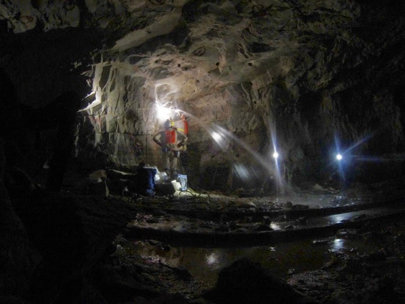
Energy-rich waters discharge kilometers below the surface in a South African mine. Credit: G. Borgonie, 2014
A team of scientists, led by the University of Toronto’s Barbara Sherwood Lollar, has mapped the location of hydrogen-rich waters found trapped kilometres beneath Earth’s surface in rock fractures in Canada, South Africa and Scandinavia.
Common in Precambrian Shield rocks — the oldest rocks on Earth — the ancient waters have a chemistry similar to that found near deep sea vents, suggesting these waters can support microbes living in isolation from the surface.
The study, to be published in Nature on December 18, includes data from 19 different mine sites that were explored by Sherwood Lollar, a geoscientist at U of T’s Department of Earth Sciences, U of T senior research associate Georges Lacrampe-Couloume, and colleagues at Oxford and Princeton universities.
The scientists also explain how two chemical reactions combine to produce substantial quantities of hydrogen, doubling estimates of global production from these processes which had previously been based only on hydrogen coming out of the ocean floor.
“This represents a quantum change in our understanding of the total volume of Earth’s crust that may be habitable,” said Sherwood Lollar.
“Until now, none of the estimates of global hydrogen production sustaining deep microbial populations had included a contribution from the ancient continents. Since Precambrian rocks make up more than 70 per cent of the surface of Earth’s crust, Sherwood Lollar likens these terrains to a “sleeping giant,” a huge area that has now been discovered to be a source of possible energy for life,” she said.
One process, known as radiolytic decomposition of water, involves water undergoing a breakdown into hydrogen when exposed to radiation. The other is a chemical reaction called serpentization, a mineral alteration reaction that is common in such ancient rocks.
This study has important implications for the search for deep microbial life. Quantifying the global hydrogen budget is key to understanding the amount of Earth’s biomass that is in the subsurface, as many deep ecosystems contain chemolithotrophic — so-called “rock-eating” — organisms that consume hydrogen. In the deep gold mines of South Africa, and under the sea, at hydrothermal vents where breaks in the fissure of Earth’s surface that release geothermally heated waters — hydrogen-rich fluids host complex microbial communities that are nurtured by the chemicals dissolved in the fluids. This study identifies a global network of sites with hydrogen-rich waters that will be targeted for exploration for deep life over the coming years.
Further, because Mars — like the Precambrian crust — consists of billions-of-year-old rocks with hydrogen-producing potential, this finding has ramifications for astrobiology. “If the ancient rocks of Earth are producing this much hydrogen, it may be that similar processes are taking place on Mars,” said Sherwood Lollar.
Other key members of the research team are Chris Ballentine of Oxford University, Tulis Onstott at Princeton University and Georges Lacrampe-Couloume of the University of Toronto. The research was funded by the Canada Research Chairs program, the Natural Sciences & Engineering Research Council, the Sloan Foundation Deep Carbon Observatory, the Canadian Space Agency and the National Science Foundation.
Reference:
Barbara Sherwood Lollar, T. C. Onstott, G. Lacrampe-Couloume, C. J. Ballentine. The contribution of the Precambrian continental lithosphere to global H2 production. Nature, 2014; 516 (7531): 379 DOI: 10.1038/nature14017
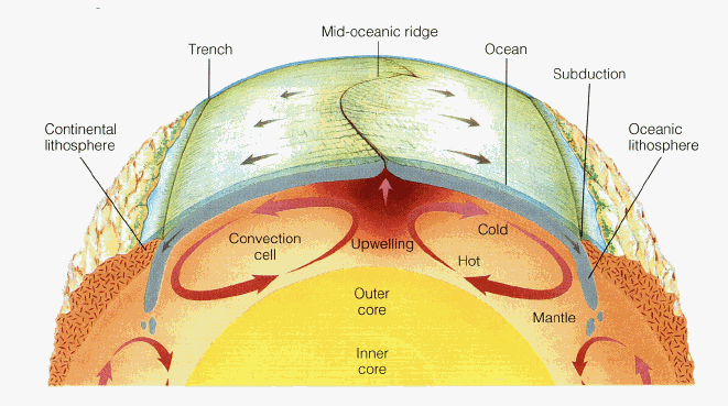
This plate tectonics diagram from the Byrd Polar and Climate Research Center shows how mantle circulation delivers new rock to the crust via mid-ocean ridges. New research suggests that mantle circulation also delivers water to the oceans.
A new study is helping to answer a longstanding question that has recently moved to the forefront of earth science: Did our planet make its own water through geologic processes, or did water come to us via icy comets from the far reaches of the solar system?
The answer is likely “both,” according to researchers at The Ohio State University — and the same amount of water that currently fills the Pacific Ocean could be buried deep inside the planet right now.
At the American Geophysical Union (AGU) meeting on Dec. 17, they report the discovery of a previously unknown geochemical pathway by which Earth can sequester water in its interior for billions of years and still release small amounts to the surface via plate tectonics, feeding our oceans from within.
In trying to understand the formation of the early Earth, some researchers have suggested that the planet was dry and inhospitable to life until icy comets pelted Earth and deposited water on the surface.
Wendy Panero, associate professor of earth sciences at Ohio State, and doctoral student Jeff Pigott are pursuing a different hypothesis: that Earth was formed with entire oceans of water in its interior, and has been continuously supplying water to the surface via plate tectonics ever since.
Researchers have long accepted that the mantle contains some water, but how much water is a mystery. And, if some geological mechanism has been supplying water to the surface all this time, wouldn’t the mantle have run out of water by now?
Because there’s no way to directly study deep mantle rocks, Panero and Pigott are probing the question with high-pressure physics experiments and computer calculations.
“When we look into the origins of water on Earth, what we’re really asking is, why are we so different than all the other planets?” Panero said. “In this solar system, Earth is unique because we have liquid water on the surface. We’re also the only planet with active plate tectonics. Maybe this water in the mantle is key to plate tectonics, and that’s part of what makes Earth habitable.”
Central to the study is the idea that rocks that appear dry to the human eye can actually contain water — in the form of hydrogen atoms trapped inside natural voids and crystal defects. Oxygen is plentiful in minerals, so when a mineral contains some hydrogen, certain chemical reactions can free the hydrogen to bond with the oxygen and make water.
Stray atoms of hydrogen could make up only a tiny fraction of mantle rock, the researchers explained. Given that the mantle is more than 80 percent of the planet’s total volume, however, those stray atoms add up to a lot of potential water.
In a lab at Ohio State, the researchers compress different minerals that are common to the mantle and subject them to high pressures and temperatures using a diamond anvil cell — a device that squeezes a tiny sample of material between two diamonds and heats it with a laser — to simulate conditions in the deep Earth. They examine how the minerals’ crystal structures change as they are compressed, and use that information to gauge the minerals’ relative capacities for storing hydrogen. Then, they extend their experimental results using computer calculations to uncover the geochemical processes that would enable these minerals to rise through the mantle to the surface — a necessary condition for water to escape into the oceans.
In a paper now submitted to a peer-reviewed academic journal, they reported their recent tests of the mineral bridgmanite, a high-pressure form of olivine. While bridgmanite is the most abundant mineral in the lower mantle, they found that it contains too little hydrogen to play an important role in Earth’s water supply.
Another research group recently found that ringwoodite, another form of olivine, does contain enough hydrogen to make it a good candidate for deep-earth water storage. So Panero and Pigott focused their study on the depth where ringwoodite is found — a place 325-500 miles below the surface that researchers call the “transition zone” — as the most likely region that can hold a planet’s worth of water. From there, the same convection of mantle rock that produces plate tectonics could carry the water to the surface.
One problem: If all the water in ringwoodite is continually drained to the surface via plate tectonics, how could the planet hold any in reserve?
For the research presented at AGU, Panero and Pigott performed new computer calculations of the geochemistry in the lowest portion of the mantle, some 500 miles deep and more. There, another mineral, garnet, emerged as a likely water-carrier — a go-between that could deliver some of the water from ringwoodite down into the otherwise dry lower mantle.
If this scenario is accurate, Earth may today hold half as much water in its depths as is currently flowing in oceans on the surface, Panero said — an amount that would approximately equal the volume of the Pacific Ocean. This water is continuously cycled through the transition zone as a result of plate tectonics.
“One way to look at this research is that we’re putting constraints on the amount of water that could be down there,” Pigott added.
Panero called the complex relationship between plate tectonics and surface water “one of the great mysteries in the geosciences.” But this new study supports researchers’ growing suspicion that mantle convection somehow regulates the amount of water in the oceans. It also vastly expands the timeline for Earth’s water cycle.
“If all of the Earth’s water is on the surface, that gives us one interpretation of the water cycle, where we can think of water cycling from oceans into the atmosphere and into the groundwater over millions of years,” she said. “But if mantle circulation is also part of the water cycle, the total cycle time for our planet’s water has to be billions of years.”
Note : The above story is based on materials provided by Ohio State University. The original article was written by Pam Frost Gorder.
This is the holotype of Eohupehsuchus brevicollis, WGSC V26003. Credit: Motani et al.; CC-BY
A new species of short-necked marine reptile from the Triassic period has been discovered in China, according to a study published December 17, 2014 in the open-access journal PLOS ONE by Xiao-hong Chen from Wuhan Centre of China Geological Survey and colleagues.
Hupehsuchia is a group of mysterious Triassic marine reptiles which have, so far, only been found in two counties in Hubei Province, China. The group is known by its modestly long neck, with nine to ten cervical vertebrae, but the authors of this study recently discovered a new species of Hupehsuchia that may show for the first time a species with a short neck (six cervical vertebrae), which they named Eohupehsuchus brevicollis.
The left forelimb of this specimen is incomplete, ending with broken digits. Scientists suspect the breakage occurred pre-burial, possibly the result of a predator attack.
In addition to the short neck, the skull shape, with narrow forehead and parietal bones on the top of the head shifted back, are distinct and further support the need to name a new species.
Analysis of related species led the researchers to believe that this new species forms the sister taxon of Hupehsuchidae.
Reference:
Chen X-h, Motani R, Cheng L, Jiang D-y Rieppel O. A Small Short-Necked Hupehsuchian from the Lower Triassic of Hubei Province, China. PLoS One, 2014 DOI: 10.1371/journal.pone.0115244
Note : The above story is based on materials provided by PLOS.
Iowa State researchers use cross-polarized lenses to examine thin, horizontal sections of ice from an experiment. The black colors tell them when they’re looking down an axis of the ice grains. And that helps them understand deformation in the ice. Credit: Image courtesy of Lucas Zoet
As a glacier’s sliding speed increases, the bed beneath the glacier can grow slipperier, according to laboratory experiments conducted by Iowa State University glaciologists.
They say including this effect in efforts to calculate future increases in glacier speeds could improve predictions of ice volume lost to the oceans and the rate of sea-level rise.
The glaciologists — Lucas Zoet, a postdoctoral research associate, and Neal Iverson, a professor of geological and atmospheric sciences — describe the results of their experiments in the Journal of Glaciology. The paper uses data collected from a newly constructed laboratory tool, the Iowa State University Sliding Simulator, to investigate glacier sliding. The device was used to explore the relationship between drag and sliding speed for comparison with the predictions of theoretical models.
“We really have a unique opportunity to study the base of glaciers with these experiments,” said Zoet, the lead author of the paper. “The other tactic you might take is studying these relationships with field observations, but with field data so many different processes are mixed together that it becomes hard to untangle the relevant data from the noise.”
Data collected by the researchers show that resistance to glacier sliding — the drag that the bed exerts on the ice — can decrease in response to increasing sliding speed. This decrease in drag with increasing speed, although predicted by some theoreticians a long as 45 years ago, is the opposite of what is usually assumed in mathematical models of the flow of ice sheets.
These are the first empirical results demonstrating that as ice slides at an increasing speed — perhaps in response to changing weather or climate — the bed can become slipperier, which could promote still faster glacier flow.
The response of glaciers to changing climate is one of the largest potential contributors to sea-level rise. Predicting glacier response to climate change depends on properly characterizing the way a glacier slides over its bed. There has been a half-century debate among theoreticians as to how to do that.
The simulator features a ring of ice about 8 inches thick and about 3 feet across that is rotated over a model glacier bed. Below the ice is a hydraulic press that can simulate the weight of a glacier several hundred yards thick. Above are motors that can rotate the ice ring over the bed at either a constant speed or a constant stress. A circulating, temperature-regulated fluid keeps the ice at its melting temperature — a necessary condition for significant sliding.
“About six years were required to design, construct, and work the bugs out of the new apparatus,” Iverson said, “but it is performing well now and allowing hypothesis tests that were formerly not possible.”
Reference:
Lucas K. Zoet, Neal R. Iverson. Experimental determination of a double-valued drag relationship for glacier sliding. Journal of Glaciology, 2015; 61 (225): 1 DOI: 10.3189/2015JoG14J174
MSL Curiosity rover at “John Klein” drill site. This self-portrait of NASA’s Mars rover Curiosity combines dozens of exposures taken by the rover’s Mars Hand Lens Imager on Feb. 3, 2013 plus three exposures taken May 10, 2013 to show two holes (in lower left quadrant) where Curiosity used its drill on the rock target “John Klein”. Credit: NASA/JPL-Caltech/MSSS
The team responsible for the Sample Analysis at Mars (SAM) instrument suite on NASA’s Curiosity rover has made the first definitive detection of organic molecules at Mars. Organic molecules are the building blocks of all known forms of terrestrial life, and consist of a wide variety of molecules made primarily of carbon, hydrogen, and oxygen atoms. However, organic molecules can also be made by chemical reactions that don’t involve life, and there is not enough evidence to tell if the matter found by the team came from ancient Martian life or from a non-biological process. Examples of non-biological sources include chemical reactions in water at ancient Martian hot springs or delivery of organic material to Mars by interplanetary dust or fragments of asteroids and comets.
The surface of Mars is currently inhospitable to life as we know it, but there is evidence that the Red Planet once had a climate that could have supported life billions of years ago. For example, features resembling dry riverbeds and minerals that only form in the presence of liquid water have been discovered on the Martian surface. The Curiosity rover with its suite of instruments including SAM was sent to Mars in 2011 to discover more about the ancient habitable Martian environment by examining clues in the chemistry of rocks and the atmosphere.
The organic molecules found by the team were in a drilled sample of the Sheepbed mudstone in Gale crater, the landing site for the Curiosity rover. Scientists think the crater was once the site of a lake billions of years ago, and rocks like mudstone formed from sediment in the lake. Moreover, this mudstone was found to contain 20 percent smectite clays. On Earth, such clays are known to provide high surface area and optimal interlayer sites for the concentration and preservation of organic compounds when rapidly deposited under reducing chemical conditions.
While the team can’t conclude that there was life at Gale crater, the discovery shows that the ancient environment offered a supply of reduced organic molecules for use as building blocks for life and an energy source for life. Curiosity’s earlier analysis of this same mudstone revealed that the environment offered water and chemical elements essential for life and a different chemical energy source.
“We think life began on Earth around 3.8 billion years ago, and our result shows that places on Mars had the same conditions at that time — liquid water, a warm environment, and organic matter,” said Caroline Freissinet of NASA’s Goddard Space Flight Center in Greenbelt, Maryland. “So if life emerged on Earth in these conditions, why not on Mars as well?” Freissinet is lead author of a paper on this research submitted to the Journal of Geophysical Research-Planets.
The organic molecules found by the team also have chlorine atoms, and include chlorobenzene and several dichloroalkanes, such as dichloroethane, dichloropropane and dichlorobutane. Chlorobenzene is the most abundant with concentrations between 150 and 300 parts-per-billion. Chlorobenzene is not a naturally occurring compound on Earth. It is used in the manufacturing process for pesticides (insecticide DDT), herbicides, adhesives, paints and rubber. Dichloropropane is used as an industrial solvent to make paint strippers, varnishes and furniture finish removers, and is classified as a carcinogen.
It’s possible that these chlorine-containing organic molecules were present as such in the mudstone. However, according to the team, it’s more likely that a different suite of precursor organic molecules was in the mudstone, and that the chlorinated organics formed from reactions inside the SAM instrument as the sample was heated for analysis. Perchlorates (a chlorine atom bound to four oxygen atoms) are abundant on the surface of Mars. It’s possible that as the sample was heated, chlorine from perchlorate combined with fragments from precursor organic molecules in the mudstone to produce the chlorinated organic molecules detected by SAM.
In 1976, the Gas Chromatograph Mass Spectrometer instrument on NASA’s Viking landers detected two simple chlorinated hydrocarbons after heating Martian soils for analysis (chloromethane and dichloromethane). However they were not able to rule out that the compounds were derived from the instrument itself, according to the team. While sources within the SAM instrument also produce chlorinated hydrocarbons, they don’t make more than 22 parts-per-billion of chlorobenzene, far below the amounts detected in the mudstone sample, giving the team confidence that organic molecules really are present on Mars.
The SAM instrument suite was built at NASA Goddard with significant elements provided by industry, university, and national and international NASA partners.
For this analysis, the Curiosity rover sample acquisition system drilled into a mudstone and filtered fine particles of it through a sieve, then delivered a portion of the sample to the SAM laboratory. SAM detected the compounds using its Evolved Gas Analysis (EGA) mode by heating the sample up to about 875 degrees Celsius (around 1,600 degrees Fahrenheit) and then monitoring the volatiles released from the sample using a quadrupole mass spectrometer, which identifies molecules by their mass using electric fields. SAM also detected and identified the compounds using its Gas Chromatograph Mass Spectrometer (GCMS) mode. In this mode, volatiles are separated by the amount of time they take to travel through a narrow tube (gas chromatography — certain molecules interact with the sides of the tube more readily and thus travel more slowly) and then identified by their signature mass fragments in the mass spectrometer.
The first evidence for elevated levels of chlorobenzene and dichloroalkanes released from the mudstone was obtained on Curiosity Sol 290 (May 30, 2013) with the third analysis of the Cumberland sample at Sheepbed. The team spent over a year carefully analyzing the result, including conducting laboratory experiments with instruments and methods similar to SAM, to be sure that SAM could not be producing the amount of organic material detected.
“The search for organics on Mars has been extremely challenging for the team,” said Daniel Glavin of NASA Goddard, a co-author on the paper. “First, we need to identify environments in Gale crater that would have enabled the concentration of organics in sediments. Then they need to survive the conversion of sediment to rock, where pore fluids and dissolved substances may oxidize and destroy organics. Organics can then be destroyed during exposure of rocks at the surface of Mars to intense ionizing radiation and oxidants. Finally, to identify any organic compounds that have survived, we have to deal with oxychlorine compounds and possibly other strong oxidants in the sample which will react with and combust organic compounds to carbon dioxide and chlorinated hydrocarbons when the samples are heated by SAM.”
As part of Curiosity’s plan for exploration, an important strategic goal was to sample rocks that represent different combinations of the variables thought to control organic preservation. “The SAM and Mars Science Laboratory teams have worked very hard to achieve this result,” said John Grotzinger of Caltech, Mars Science Laboratory’s Project Scientist. “Only by drilling additional rock samples in different locations, and representing different geologic histories were we able to tease out this result. At the time we first saw evidence of these organic molecules in the Cumberland sample it was uncertain if they were derived from Mars, however, additional drilling has not produced the same compounds as might be predicted for contamination, indicating that the carbon in the detected organic molecules is very likely of Martian origin.”
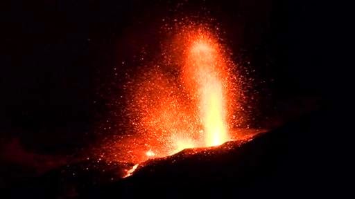
Screengrab from video footage obtained by AFP from TCV (Televisão de Cabo Verde) shows lava spewing from the Pico do Fogo volcano on the island of Fogo in Cape Verde on an unspecified date in December 2014
The biggest eruption of Cape Verde volcano Pico do Fogo in decades has destroyed two villages and threatens a forest reserve Tuesday, officials said.
Some 1,500 people were forced to abandon their homes before the lava flow reached the villages of Portela and Bangeira on Fogo island in the Atlantic archipelago, fire brigade chief Arlindo Lima said late Monday on national radio.
More than 1,000 people were evacuated from the Cha das Caldeiras region at the foot of the volcano immediately after it first erupted on November 23, while officials closed the airport as the skies darkened with ash.
Lima, who heads civil protection services, said that the lava gained ground on Sunday. “The lava front, (which was) more than 500 metres (547 yards) north of outlying houses in Bangeira a week ago, has swept over much of the village and continues to move forward.”
The village of Portela has also been destroyed, according to Lima and local journalists.
Cape Verde is a volcanic archipelago comprised of 10 islands, nine of them inhabited by a population of about 530,000 people. They mostly live by fishing, making garments for export, a thriving tourist trade and remittances from the islands’ diaspora.
Volcanic activity is rare, but when its highest peak Pico do Fogo erupted, expert Bruno Faria told state-owned Radio Cape Verde that the initial blast was “much greater than the one in 1995”, which showered the island with ash. Residents said that gas was also coming out of the crater.
“The eruption was very fast. But we are appealing to the people for calm,” Interior Minister Marisa Morais told the radio station.
Pico do Fogo, which stands almost 2,900 metres (9,500 feet), quietened down for four days after the first eruption, but started to blow again last weekend.
Authorities have warned inhabitants of Fonsaco village to prepare to leave as the lava advances, while they also fear for the Monte Velho forest reserve, lying in its path.
“There’s a whole local economy and a whole way of life that the volcano has claimed in the space of just 22 days,” local journalist Arlinda Neves said after Portela and Bangeira were “struck off the map”.
“It’s more than a century and a half of history that has literally been wiped out,” she added, with some of the buildings destroyed dating back to the 1860s.
As a glacier’s sliding speed increases, the bed beneath the glacier can grow slipperier, according to laboratory experiments conducted by Iowa State University glaciologists.
They say including this effect in efforts to calculate future increases in glacier speeds could improve predictions of ice volume lost to the oceans and the rate of sea-level rise.
The glaciologists – Lucas Zoet, a postdoctoral research associate, and Neal Iverson, a professor of geological and atmospheric sciences – describe the results of their experiments in the Journal of Glaciology. The paper uses data collected from a newly constructed laboratory tool, the Iowa State University Sliding Simulator, to investigate glacier sliding. The device was used to explore the relationship between drag and sliding speed for comparison with the predictions of theoretical models.
“We really have a unique opportunity to study the base of glaciers with these experiments,” said Zoet, the lead author of the paper. “The other tactic you might take is studying these relationships with field observations, but with field data so many different processes are mixed together that it becomes hard to untangle the relevant data from the noise.”
Data collected by the researchers show that resistance to glacier sliding – the drag that the bed exerts on the ice – can decrease in response to increasing sliding speed. This decrease in drag with increasing speed, although predicted by some theoreticians a long as 45 years ago, is the opposite of what is usually assumed in mathematical models of the flow of ice sheets.
These are the first empirical results demonstrating that as ice slides at an increasing speed – perhaps in response to changing weather or climate – the bed can become slipperier, which could promote still faster glacier flow.
The response of glaciers to changing climate is one of the largest potential contributors to sea-level rise. Predicting glacier response to climate change depends on properly characterizing the way a glacier slides over its bed. There has been a half-century debate among theoreticians as to how to do that.
The simulator features a ring of ice about 8 inches thick and about 3 feet across that is rotated over a model glacier bed. Below the ice is a hydraulic press that can simulate the weight of a glacier several hundred yards thick. Above are motors that can rotate the ice ring over the bed at either a constant speed or a constant stress. A circulating, temperature-regulated fluid keeps the ice at its melting temperature – a necessary condition for significant sliding.
“About six years were required to design, construct, and work the bugs out of the new apparatus,” Iverson said, “but it is performing well now and allowing hypothesis tests that were formerly not possible.”
Washington, D.C.– Recent advances in our understanding of the quantities, movements, forms and origin of carbon in Earth are summarized in a just-published report. The research represents face-paced progress on the depths of the biosphere, Earth, what erupts from volcanoes and leaks from sea floors, what descends back into Earth’s great depths, and the nature of carbon-bearing materials within planets.
The Carnegie Institution for Science is the institutional home of the DCO Secretariat. Carnegie’s Robert Hazen and Russell Hemley are the executive and co-executive directors of this ambitious, transdisciplinary, 10-year effort. The group issued a midterm scientific report at the AGU today entitled, Carbon in Earth: Quantities, Movements, Forms and Origins now available online and in print. The research has been conducted by an international team under the auspices of the Deep Carbon Observatory.
The carbon in the atmosphere, ocean, on the surface, life, and other shallow, near surface reservoirs accounts for only about 10% of Earth’s carbon. The mysterious 90% is what the Deep Carbon Observatory is exploring. The unique, 10-year program began in 2009 to explore, experiment, and build a new scientific field with a network of scientists from more than 40 countries. The Alfred P. Sloan Foundation awarded Carnegie the initial grant to fund the Deep Carbon Observatory at the institution’s Geophysical Laboratory. Other funders include scientific organizations, institutions, and academies around the world.
DCO scientists will also present more than 100 talks and posters at the American Geophysical Union meeting in progress beginning today in San Francisco.
“The Deep Carbon Observatory has played a key role in promoting studies around the world of carbon in Earth and in extreme environments,” remarked Hemley. “Enormous progress has been made during the first five years. However, there is still a lot we don’t understand about this essential element and the environments in which it is found. The community is excited about answering many of the remaining questions during the second five years of the program.”
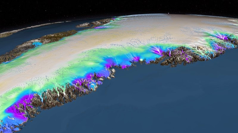
This NASA visualization shows the change in the surface elevation of the southeast region of the Greenland ice sheet between 2003 and 2012. Thinning near coastal regions is shown in green, blue and purple. In addition, blue/white flows indicate the direction and speed of the ice movement. In the new study, University at Buffalo geophysicist Beata Csatho and her team found areas of rapid shrinkage in southeast Greenland that current climate models don’t address, which suggests that the ice sheet may lose ice more rapidly in the near future than previously thought. Credit: NASA’s Goddard Space Flight Center Scientific Visualization Studio
The Greenland Ice Sheet is the second-largest body of ice on Earth. It covers an area about five times the size of New York State and Kansas combined, and if it melts completely, oceans could rise by 20 feet. Coastal communities from Florida to Bangladesh would suffer extensive damage.
Now, a new study is revealing just how little we understand this northern behemoth.
Led by geophysicist Beata Csatho, PhD, an associate professor of geology at the University at Buffalo, the research provides what the authors think is the first comprehensive picture of how Greenland’s ice is vanishing. It suggests that current ice sheet modeling studies are too simplistic to accurately predict the future contributions of the entire Greenland Ice Sheet to sea level rise, and that Greenland may lose ice more rapidly in the near future than previously thought.
“The great importance of our data is that for the first time, we have a comprehensive picture of how all of Greenland’s glaciers have changed over the past decade,” Csatho says.
“This information is crucial for developing and validating numerical models that predict how the ice sheet may change and contribute to global sea level over the next few hundred years,” says Cornelis J. van der Veen, PhD, professor in the Department of Geography at the University of Kansas, who played a key role in interpreting glaciological changes.
The project was a massive undertaking, using satellite and aerial data from NASA’s ICESat spacecraft and Operation IceBridge field campaign to reconstruct how the height of the Greenland Ice Sheet changed at nearly 100,000 locations from 1993 to 2012.
Ice loss takes place in a complex manner, with the ice sheet both melting and calving ice into the ocean.
The study had two major findings:
• First, the scientists were able to provide new estimates of annual ice loss at high spatial resolution.
• Second, the research revealed that current models fail to accurately capture how the entire Greenland Ice Sheet is changing and contributing to rising oceans.
The second point is crucial to climate change modelers.
Today’s simulations use the activity of four well-studied glaciers — Jakobshavn, Helheim, Kangerlussuaq and Petermann — to forecast how the entire ice sheet will dump ice into the oceans.
But the new research shows that activity at these four locations may not be representative of what is happening with glaciers across the ice sheet. In fact, glaciers undergo patterns of thinning and thickening that current climate change simulations fail to address, Csatho says.
“There are 242 outlet glaciers wider than 1.5 km on the Greenland Ice Sheet, and what we see is that their behavior is complex in space and time,” Csatho says. “The local climate and geological conditions, the local hydrology — all of these factors have an effect. The current models do not address this complexity.”
The team identified areas of rapid shrinkage in southeast Greenland that today’s models don’t acknowledge. This leads Csatho to believe that the ice sheet could lose ice faster in the future than today’s simulations would suggest.
The results will be published on Dec. 15 in the Proceedings of the National Academy of Sciences.
How much ice is the Greenland Ice Sheet losing?
To analyze how the height of the ice sheet was changing, Csatho and UB research professor and photogrammetrist Anton Schenk, PhD, developed a computational technique called Surface Elevation Reconstruction And Change detection to fuse together data from NASA satellite and aerial missions.
The analysis found that the Greenland Ice Sheet lost about 243 metric gigatons of ice annually — equivalent to about 277 cubic kilometers of ice per year — from 2003-09, the period for which the team had the most comprehensive data. This loss is estimated to have added about 0.68 millimeters of water to the oceans annually.
The figures are averages, and ice loss varied from year to year, and from region to region.
Why are today’s projections of sea level rise flawed, and how can we fix them?
Glaciers don’t just gradually lose mass when the temperature rises. That’s one reason it’s difficult to predict their response to global warming.
In the study, scientists found that some of Greenland’s glaciers thickened even when the temperature rose. Others exhibited accelerated thinning. Some displayed both thinning and thickening, with sudden reversals.
As a step toward building better models of sea level rise, the research team divided Greenland’s 242 glaciers into 7 major groups based on their behavior from 2003-09.
“Understanding the groupings will help us pick out examples of glaciers that are representative of the whole,” Csatho says. “We can then use data from these representative glaciers in models to provide a more complete picture of what is happening.”
In a new project, she and colleagues are investigating why different glaciers respond differently to warming. Factors could include the temperature of the surrounding ocean; the level of friction between a glacier and the bedrock below; the amount of water under a glacier; and the geometry of the fjord.
“The physics of these processes are not well understood,” Csatho says.
The NASA missions: A colossal undertaking
The study combined data from various NASA missions, including:
• NASA’s Ice, Cloud and Land Elevation Satellite (ICESat), which measured the ice sheet’s elevation multiple times a year at each of the nearly 100,000 locations from 2003-09.
• NASA’s, massive aerial survey that employs highly specialized research aircrafts to collect data at less frequent intervals than ICESat. These missions began measuring the Greenland Ice Sheet’s elevation in 1993. Operation IceBridge was started in 2009 to bridge the time between ICESat-1 and ICESat-2, and will continue until at least 2017, when NASA’s next generation ICESat-2 satellite is expected to come online.
Csatho says the new study shows why careful monitoring is critical: Given the complex nature of glacier behavior, good data is crucial to building better models.
Collaborators
Besides Csatho, Schenk and van der Veen, the project included additional researchers from the University at Buffalo, Utrecht University in The Netherlands, the Technical University of Denmark and Florida Atlantic University.
Video:
Reference:
Beata M. Csatho, Anton F. Schenk, Cornelis J. van der Veen, Gregory Babonis, Kyle Duncan, Soroush Rezvanbehbahani, Michiel R. van den Broeke, Sebastian B. Simonsen, Sudhagar Nagarajan, and Jan H. van Angelen. Laser altimetry reveals complex pattern of Greenland Ice Sheet dynamics. PNAS, December 15, 2014 DOI: 10.1073/pnas.1411680112
Note : The above story is based on materials provided by University at Buffalo. The original article was written by Charlotte Hsu.
Edmontosaurus regalis roamed around what is now Edmonton about 71 million years ago. Credit: Michael W. Skrepnick
An exciting new special issue of the Canadian Journal of Earth Sciences shines the spotlight on the Danek Bonebed in Edmonton, Alberta and increases our knowledge of Edmonton’s urban dinosaurs, especially the iconic hadrosaurid Edmontosaurus.
Well-preserved, articulated dinosaur specimens often receive much attention from scientists and the public, but bonebeds provide a great deal of information that even the most spectacular articulated specimens cannot. Because of the amount of fossil material, the quality of preservation, ease of preparation, and volume of associated data, the site allows for a diversity of research projects tied together by a common theme.
Guest editors of this thematic issue featuring the Danek Bonebed include Victoria Arbour (University of Alberta), Michael Ryan (Cleveland Museum of Natural History) and Andrew Farke (Raymond M. Alf Museum of Paleontology) with support from Michael Burns, Eva Koppelhus and Phil Currie (from University of Alberta).
As the Special issue’s introduction explains:
“The bonebed was discovered by Danek Mozdzenski, an amateur fossil collector from Edmonton, on March 31, 1989 (Bell and Campione, 2014) and was initially excavated by the Royal Tyrrell Museum of Palaeontology in 1989 and 1991, during which time approximately 80 specimens were collected, including a partial articulated skeleton. The bonebed was reopened by the University of Alberta Laboratory for Vertebrate Palaeontology in 2006, and has since produced over 800 catalogued specimens.”
This issue’s 11 articles collect and share a wealth of information from the Danek Bonebed (Royal Tyrrell Museum of Palaeontology locality # L2379), which has proven to be an invaluable source of specimens for palaeontological research projects, and is important as a teaching and outreach tool.
In fact, a University of Alberta field course in vertebrate palaeontology centres on the Danek Bonebed, giving students a taste of field techniques, data collection, specimen curation and preservation, and allows them to work on original research projects. Many of the contributions in this special issue are derived from these small independent research projects.
At the Bonebed, participants excavate, prepare and research specimens and data that become part of the collections of the University of Alberta Laboratory of Vertebrate Paleontology. In addition, the condition of the material found there also lends itself well to relatively easy preparation by volunteers in a “Dino Lab” Volunteer Preparation Program. Volunteers range from university students to interested members of the public, and the program represents a significant form of public engagement and citizen science at the university.
Palaeontologists, graduate students, undergraduate students and volunteers have all played a role in the excavation, preparation, curation, research and display of dinosaur bones from the Danek Bonebed, and the editors are “grateful for their efforts in making this special issue of the Canadian Journal of Earth Sciences possible.”
Reference:
“The Danek Edmontosaurus Bonebed: new insights on the systematics, biogeography, and palaeoecology of Late Cretaceous dinosaur communities” www.nrcresearchpress.com/toc/cjes/51/11 special issue of the Canadian Journal of Earth Sciences was published today.
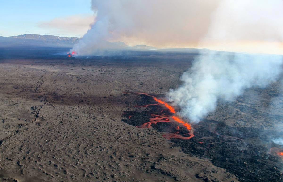
Faults and two eruptive fissures active on 5 September 2014 above the northern end of the segmented dyke that grew laterally in a rifting event at the Bárðarbunga volcanic system Iceland in 2014. Credit: Thórdís Högnadóttir, University of Iceland
New research into an Icelandic eruption has shed light on how the Earth’s crust forms, according to a paper published today in Nature.
When the Bárðarbunga volcano, which is buried beneath Iceland’s Vatnajökull ice cap, reawakened in August 2014, scientists had a rare opportunity to monitor how the magma flowed through cracks in the rock away from the volcano. The molten rock forms vertical sheet-like features known as dykes, which force the surrounding rock apart.
Study co-author Professor Andy Hooper from the Centre for Observation and Modelling of Earthquakes, volcanoes and Tectonics (COMET) at the University of Leeds explained: “New crust forms where two tectonic plates are moving away from each other. Mostly this happens beneath the oceans, where it is difficult to observe.
“However, in Iceland this happens beneath dry land. The events leading to the eruption in August 2014 are the first time that such a rifting episode has occurred there and been observed with modern tools, like GPS and satellite radar.”
Although it has a long history of eruptions, Bárðarbunga has been increasingly restless since 2005. There was a particularly dynamic period in August and September this year, when more than 22,000 earthquakes were recorded in or around the volcano in just four weeks, due to stress being released as magma forced its way through the rock.
Using GPS and satellite measurements, the team were able to track the path of the magma for over 45km before it reached a point where it began to erupt, and continues to do so to this day. The rate of dyke propagation was variable and slowed as the magma reached natural barriers, which were overcome by the build-up of pressure, creating a new segment.
The dyke grows in segments, breaking through from one to the next by the build up of pressure. This explains how focused upwelling of magma under central volcanoes is effectively redistributed over large distances to create new upper crust at divergent plate boundaries, the authors conclude.
As well as the dyke, the team found ‘ice cauldrons’ – shallow depressions in the ice with circular crevasses, where the base of the glacier had been melted by magma. In addition, radar measurements showed that the ice inside Bárðarbunga’s crater had sunk by 16m, as the volcano floor collapsed.
COMET PhD student Karsten Spaans from the University of Leeds, a co-author of the study, added: “Using radar measurements from space, we can form an image of caldera movement occurring in one day. Usually we expect to see just noise in the image, but we were amazed to see up to 55cm of subsidence.”
Like other liquids, magma flows along the path of least resistance, which explains why the dyke at Bárðarbunga changed direction as it progressed. Magma flow was influenced mostly by the lie of the land to start with, but as it moved away from the steeper slopes, the influence of plate movements became more important.
Summarising the findings, Professor Hooper said: “Our observations of this event showed that the magma injected into the crust took an incredibly roundabout path and proceeded in fits and starts.
“Initially we were surprised at this complexity, but it turns out we can explain all the twists and turns with a relatively simple model, which considers just the pressure of rock and ice above, and the pull exerted by the plates moving apart.”
Reference:
Freysteinn Sigmundsson, Andrew Hooper, Sigrún Hreinsdóttir, Kristín S. Vogfjörd, Benedikt G. Ófeigsson, Elías Rafn Heimisson, Stéphanie Dumont, Michelle Parks, Karsten Spaans, Gunnar B. Gudmundsson, Vincent Drouin, Thóra Árnadóttir, Kristín Jónsdóttir, Magnús T. Gudmundsson, Thórdís Högnadóttir, Hildur María Fridriksdóttir, Martin Hensch, Páll Einarsson, Eyjólfur Magnússon, Sergey Samsonov, Bryndís Brandsdóttir, Robert S. White, Thorbjörg Ágústsdóttir, Tim Greenfield, Robert G. Green, Ásta Rut Hjartardóttir, Rikke Pedersen, Richard A. Bennett, Halldór Geirsson, Peter C. La Femina, Helgi Björnsson, Finnur Pálsson, Erik Sturkell, Christopher J. Bean, Martin Möllhoff, Aoife K. Braiden, Eva P. S. Eibl. Segmented lateral dyke growth in a rifting event at Bárðarbunga volcanic system, Iceland. Nature, 2014; DOI: 10.1038/nature14111