The fault responsible for the 9.0 magnitude Tohoku earthquake had been relieving stress at a gradually accelerating rate for years before the 2011 quake.
Stanford scientists have found evidence that sections of the fault responsible for the 9.0 magnitude Tohoku earthquake that devastated northern Japan in 2011 were relieving seismic stress at a gradually accelerating rate for years before the quake.
This “decoupling” process, in which the edges of two tectonic plates that are frictionally locked together slowly became unstuck, transferred stress to adjacent sections that were still locked. As a result, the quake, which was the most powerful ever recorded to hit Japan, may have occurred earlier than it might have otherwise, said Andreas Mavrommatis, a graduate student in Stanford’s School of Earth Sciences.
Mavrommatis and his advisor, Paul Segall, a professor of geophysics at Stanford, reached their conclusions after analyzing 15 years’ worth of GPS measurements from the Japanese island of Honshu. Their results were published earlier this year in the journal Geophysical Research Letters.
“We looked at northeastern Japan, which has one of the densest and longest running high-precision GPS networks in the world,” Mavrommatis said.
Segall said, “The measurements indicated the plate boundary was gradually becoming less locked over time. That was surprising.”
The scientists will present their work, “Decadal-Scale Decoupling of the Japan Trench Prior to the 2011 Tohoku-Oki Earthquake from Geodetic and Repeating-Earthquake Observations,” Dec. 17 at the American Geophysical Union’s Fall Meeting in San Francisco. The talk will take place at 5 p.m. PT at the Moscone Convention Center in Moscone South, Room 306.
The pair’s hypothesis is further supported by a recent analysis they conducted of so-called repeating earthquakes offshore of northern Honshu. The small quakes, which were typically magnitude 3 or 4, occurred along the entire length of the fault line, but each one occurred at the same spot every few years. Furthermore, many of them were repeating not at a constant but an accelerating rate, the scientists found. This acceleration would be expected if the fault were becoming less locked over time, Mavrommatis said, because the decoupling process would have relieved pent-up stress along some sections of the fault but increased stress on adjacent sections.
“According to our model, the decoupling process would have had the effect of adding stress to the section of the fault that nucleated the Tohoku quake,” Segall said. “We suspect this could have accelerated the occurrence of the earthquake.”
The scientists caution that their results cannot be used to predict the occurrence of the next major earthquake in Japan, but it could shed light on the physical processes that operate on faults that generate the world’s largest quakes.
Reference:
Andreas P. Mavrommatis, Paul Segall, Kaj M. Johnson. A decadal-scale deformation transient prior to the 2011Mw9.0 Tohoku-oki earthquake. Geophysical Research Letters, 2014; DOI: 10.1002/2014GL060139
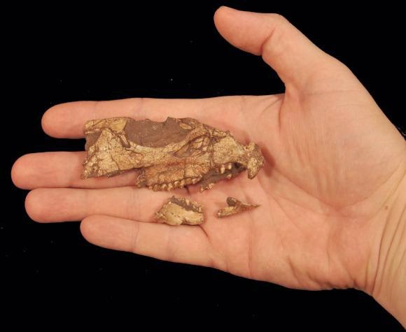
A fossil skull of Aquilops americanus is shown in this handout photo provided by Andrew A Farke December 9, 2014. Credit: Reuters/Andrew A. Farke/Handout via Reuters
It was a dinosaur about the length of a crow and the weight of a bunny. But this modest plant-eater that lived about 108 million years ago in southern Montana foreshadowed the monstrous horned dinosaurs that trod North America millions of years later.
Scientists on Wednesday announced the discovery of the fossil of the oldest known horned dinosaur species from North America, a creature called Aquilops americanus that was a close cousin to similar dinosaurs from Asia.
The horned dinosaur lineage, called ceratopsians, arose in Asia but reached its apex in North America with the likes of Triceratops, a 30-foot-long (nine meters), six-ton beast with lengthy, sharp horns over its eyes, another over its nose and a bony shield above its neck.
Aquilops lived about 40 million years before Triceratops and nearly 20 million years before Zuniceratops, the next oldest ceratopsian identified from North America.
“Aquilops is known from a skull and lower jaws, which allow us to nail down its position in the dinosaur family tree pretty precisely,” said paleontologist Andrew Farke of the Raymond M. Alf Museum of Paleontology in Claremont, California, who led the study published in the scientific journal PLOS ONE.
“Most importantly, Aquilops is far more closely related to horned dinosaurs from Asia than it is to horned dinosaurs from North America such as Triceratops. This shows that horned dinosaurs probably migrated into North America from Asia at least two different times, maybe even more,” Farke added.
Aquilops is estimated at about 2 feet (60 cm) long and 2.5 pounds (1.1 kg), with a skull 3.3 inches (8.4 cm) long.
Like later horned dinosaurs, it possessed a sharp beak used to snip off the plants it munched. Unlike later ceratopsians, it was probably bipedal and did not have horns on its face. It did have a set of spikes on its cheeks.
“Aquilops is part of a building body of evidence that shows Asian dinosaurs, and early mammals, showing up in North America during the Early Cretaceous Period, between 110 and 105 million years ago,” added Farke, who said early members of Tyrannosaurus rex’s lineage also had Asian origins.
Horned dinosaurs were remarkably successful in terms of species diversity and abundance, said University of Oklahoma paleontologist Richard Cifelli, another of the researchers.
“By virtue of their slicing-style jaw movement and blade-like tooth series, they appear to have been well adapted to plant eating,” Cifelli added.
Aquilops americanus means “Eagle Face from the Americas.”
Note : The above story is based on materials provided by Reuters. The original article was Reporting by Will Dunham; Editing by Sandra Maler.
Oil reservoirs are scattered deep inside Earth like far-flung islands in the ocean, so their inhabitants might be expected to be very different, but a new study led by Dartmouth College and University of Oslo researchers shows these underground microbes are social creatures that have exchanged genes for eons.
The study, which was led by researchers at Dartmouth College and the University of Oslo, appears in the ISME Journal.
The findings shed new light on the “deep biosphere,” or the vast subterranean realm whose single-celled residents are estimated to be roughly equal in number and diversity to all the microbes inhabiting the surface’s land, water and air. Deep microbial research may also help scientists to better understand life’s early evolution on Earth and aid the search for life on Mars and other planets.
Some scientists support a “burial and isolation” scenario in which bacteria living in oil reservoirs are descendants of isolated bacterial communities buried with sediments that over time became oil reservoirs. “Instead, our analysis supports a more complex ‘colonization’ view, where bacteria from subsurface and marine populations have been continuously migrating into the oil reservoirs and influencing their genetic composition since ancient times,” says co-author Olga Zhaxybayeva, an assistant professor at Dartmouth.
Since the 1980s, a growing number of microbial life forms have been discovered deep underground, but many questions remain, including when and how these microorganisms came to inhabit places where temperatures and pressure are extreme and nutrients and energy can be scarce. Microorganisms are the oldest form of life on Earth and continue to play a crucial role in the planet’s ecosystem. Those bacteria dwelling underground live not off sunlight energy but Earth’s inner heat, chemicals and nutrients.
In their new paper, researchers asked a number of questions, including: do buried bacteria adapt to living in oil reservoirs as they form from sediments? Do bacteria evolve in isolation, or do they migrate to oil reservoirs and exchange genes with surrounding bacteria, including surface ones introduced through drilling fluids used in oil production? The researchers analyzed 11 genomes of Thermotoga, an ancient lineage of heat-loving bacteria, taken from oil reservoirs in the North Sea and Japan and from hot water vents on the ocean floor near the Kuril Islands north of Japan, Italy and the Azores, an island chain west of Portugal. They also analyzed Thermotoga community DNA from the environment (so-called metagenomes) from North America and Australia that are available in public databases.
The results reveal extensive gene flow across all the sampled environments, suggesting the bacteria do not stay isolated in the oil reservoirs but instead have long migrated to and colonized the reservoirs and contributed to their genetic make-up. “The pathway of the gene flow remains to be explained, but we hypothesize that a lot of the gene flow may happen within the subsurface,” says co-author Camilla Nesbø, a researcher at Centre for Ecological and Evolutionary Synthesis at the University of Oslo. Zhaxybayeva and Nesbø’s previous research showed that Thermotoga and its close relatives have exchanged small pieces of genome with Archaea, an ancient single-celled life form different from bacteria, and with another distant group of bacteria, Firmicutes.
Reference:
Camilla L Nesbø, Kristen S Swithers, Håkon Dahle, Thomas HA Haverkamp, Nils-Kåre Birkeland, Tatiana Sokolova, Ilya Kublanov, Olga Zhaxybayeva. Evidence for extensive gene flow and Thermotoga subpopulations in subsurface and marine environments. The ISME Journal, 2014; DOI: 10.1038/ismej.2014.238
Note : The above story is based on materials provided by Dartmouth College.
Sixty-six million years ago, an asteroid more than five miles wide smashed into the Earth at 70,000 miles per hour, instantly vaporizing upon impact. The strike obliterated most terrestrial life, including the dinosaurs, in a geological instant: Heavy dust blocked out the sun, setting off a cataclysmic chain of events from the bottom of the food chain to the top, killing off more than three-quarters of Earth’s species—or so the popular theory goes.
But now scientists at MIT and elsewhere have found evidence that a major volcanic eruption began just before the impact, possibly also playing a role in the extinction.
The team precisely dated rocks from the Deccan Traps—a region of west-central India that preserves remnants of one of the largest volcanic eruptions on Earth. Based on their analysis, the researchers determined that the eruption began 250,000 years before the asteroid strike and continued for 500,000 years after the giant impact, spewing a total of 1.5 million square kilometers of lava.
The immense and long-lasting volcanism may have released dangerous levels of volatile chemicals into the air, poisoning the atmosphere and oceans.
“If models of volatile release are correct, we’re talking about something similar to what’s happening today: lots of carbon dioxide being emitted into the atmosphere very rapidly,” says Michael Eddy, a graduate student in MIT’s Department of Earth, Atmospheric and Planetary Sciences (EAPS). “Ultimately what that can do is lead to ocean acidification, killing a significant portion of plankton—the base of the food chain. If you wipe them out, then you’d have catastrophic effects.”
Based on the new, more precise dates for the Deccan Traps, the researchers believe the massive eruptions may have played a significant role in extinguishing the dinosaurs—although the exact kill mechanism may never be known.
“I don’t think the debate will ever go away,” says Sam Bowring, the Robert R. Shrock Professor of Earth and Planetary Sciences at MIT. “The [asteroid] impact may have caused the extinction. But perhaps its effect was enhanced because things were softened up a bit by the eruption of these volcanoes.”
Bowring and Eddy are authors of a paper published in Science, along with colleagues at Princeton University, the University of Lausanne in Switzerland, and Amravati University in India.
A one-two punch
Prior to 1980, the exact cause of dinosaurs’ demise was unknown; one hypothesis proposed that they were killed off by massive volcanic eruptions. (Similar episodes have subsequently been shown to have played a role in two other mass extinctions, the end-Permian and end-Triassic.) But the 1980 discovery in Italy of iridium, a rare element primarily found in extraterrestrial materials, suggested otherwise.
“They eventually found a crater in the early ’90s, so the smoking gun of the story seemed to be perfect: An asteroid caused the mass extinction,” Eddy says. “In fact, a few people have suggested that there is evidence for environmental degradation before the impact.”
It’s long been known that a major eruption occurred in India around the time of the end-Cretaceous extinction, but this event had never been precisely dated. The MIT and Princeton researchers used high-precision geochronology to determine the age of rocks in the Deccan Traps, to evaluate whether the eruptions began before the extinction—a necessity, if volcanism was indeed the cause.
“The story that is emerging is that perhaps both might have been involved,” Bowring says. “Perhaps the end of the dinosaurs was caused by a one-two punch.”
Dating from the bottom up
In December 2013, the team made an expedition to the Deccan Traps, east of Mumbai, a region known for its expansive, step-like topology. (The term “traps” is Swedish for “stairs.”)
For two weeks, the researchers looked for volcanic rocks that might contain zircon—a uranium-containing mineral that forms in magma shortly after an eruption, and that can be used as a very precise clock for determining the age of rocks; the mineral typically crystallizes in magma containing high amounts of silica and zirconium.
The researchers collected more than 50 samples of rocks from the region representing the largest pulse of volcanism. Fortunately, samples from both the bottom and top of this volcanic layer contained zircon, allowing the team to pinpoint the timing of the beginning and end of the Deccan Traps eruptions.
The researchers analyzed the rocks separately at Princeton and MIT to make sure the dates determined in one lab could be replicated in another lab. In both laboratories, the scientists pulverized rocks and separated out millimeter-length grains of zircon. To determine the age of zircon, and the rock from which it came, the teams measured the ratio of uranium to lead isotopes.
The group’s analysis indicates that the region of the Deccan Traps started erupting 250,000 years before the asteroid strike, continuing for another 500,000 years after the impact.
“We have 750,000 years as the duration for the main pulse of volcanism, but it’d be nice to know whether that time represents a constant flux of magma, or if pulses of magmatism were erupted over an even shorter period of time,” Eddy says. “Can we pick things apart at the 10,000-year level and see correlations between an individual pulse of volcanism and environmental change? That’s where we need to go with this study.”
Adds Bowring: “We’re getting better and better at dating mass-extinction events, but we’re not having a comparable improvement in our understanding of what caused them. Now that the timing is so well-resolved, I think there will be people coming back to think about the cause with new vigor.”
Reference:
“U-Pb geochronology of the Deccan Traps and relation to the end-Cretaceous mass extinction” Science DOI: 10.1126/science.aaa0118
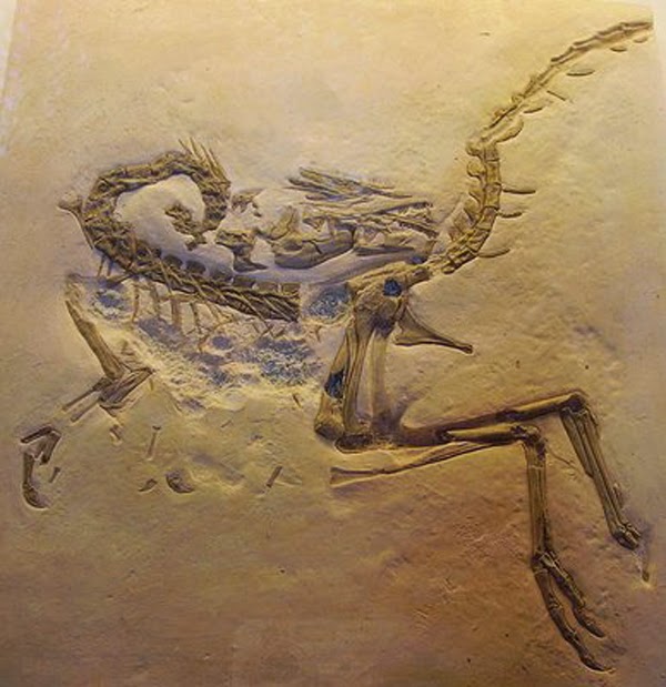
This Compsognathus skeleton was discovered in the 1850s in the same Solnhofen limestone that yielded Archaeopteryx. Credit: Ballista, Creative Commons ShareAlike Attribution 3.0
New research from the University of Kent suggests that chickens and turkeys have experienced fewer gross genomic changes than other birds as they evolved from their dinosaur ancestor.
Professor Darren Griffin and a team at the University’s School of Biosciences have conducted research that suggests that chromosomes of the chicken and turkey lineage have undergone the fewest number of changes compared to their ancient avian ancestor, thought to be a feathered dinosaur.
The Kent research is part of a study by a consortium of leading scientists into avian or bird genomes, which tell a story of species evolution. The living descendants of dinosaurs were thought to have undergone a rapid burst of evolution after most dinosaur species were wiped out. The detailed family tree of modern birds has however confused biologists for centuries and the molecular details of how birds arrived at the spectacular biodiversity of more than 10,000 species is barely known.
Professor Griffin explained: ‘Bird genomes are distinctive in that they have more tiny microchromosomes than any other vertebrate group. These small packages of gene-rich material are thought to have been present in their dinosaur ancestors.
‘We found that the chicken has the most similar overall chromosome pattern to its avian dinosaur ancestor.’
The research, which formed part of a vast study carried out over the past four years by the international Avian Phylogenomics Consortium, involved the analysis of the whole genome structure of the chicken, turkey, Pekin duck, zebra finch and budgerigar.
Professor Griffin and the other leaders of the research team ¬- Kent colleague Dr Michael Romanov as well as Dr Denis Larkin and Dr Marta Farré from the Royal Veterinary College, University of London — studied data from a total of 21 avian genomes and one reptile species. The team focused on the six best-assembled genomes to put together a karyotype — organised profile — of the dinosaur ancestor for each chromosome.
The researchers also found that the fastest rate of change had occurred in the zebra finch and budgerigar, consistent with more rapid speciation events in songbirds and their relatives.
Reference:
Michael N Romanov, Marta Farré, Pamela E Lithgow, Katie E Fowler, Benjamin M Skinner, Rebecca O¿Connor, Gothami Fonseka, Niclas Backström, Yoichi Matsuda, Chizuko Nishida, Peter Houde, Erich D Jarvis, Hans Ellegren, David W Burt, Denis M Larkin, Darren K Griffin. Reconstruction of gross avian genome structure, organization and evolution suggests that the chicken lineage most closely resembles the dinosaur avian ancestor. BMC Genomics, 2014; 15 (1): 1060 DOI: 10.1186/1471-2164-15-1060
Note : The above story is based on materials provided by University of Kent.
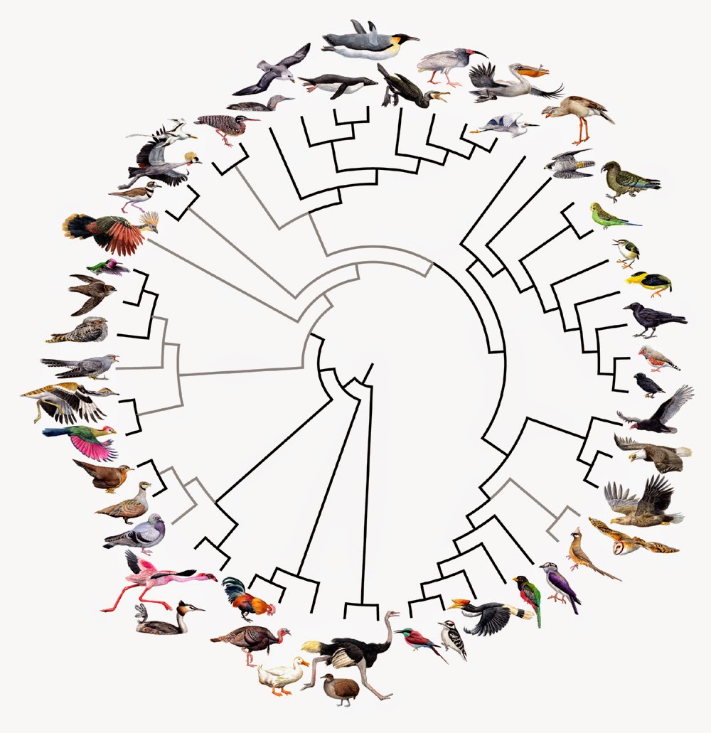
The Avian Phylogenomics Consortium’s work over four years has brought together more than 200 scientists to better understand the evolution of birds. Credit: Jon Fjelds
The most ambitious genetic study ever undertaken on bird evolution has found that almost all modern birds diversified after the dinosaurs became extinct 66 million years ago.
“The popular view until now has been that the extraordinary diversity of birds began during the dinosaur age but we found little support for this,” said Associate Professor Simon Ho, from the University of Sydney who led a major component of the research looking at evolutionary timescale.
An international collaboration of scientists worked for four years to sequence, assemble and compare the full genomes of 48 bird species representing all major branches of modern birds. It is the largest whole genomic study across a single vertebrate class ever undertaken.
Their results appear in a special edition of Science on 12 December (with simultaneous publications of related articles in other high profile journals).
Associate Professor Ho, from the University’s School of Biological Sciences, is an author on a Science paper and two articles in GigaScience. He contributed his expertise in using a technique known as ‘molecular clock’ analysis to estimate birds’ evolutionary timescales, using genome data and fossil evidence.
His research helped confirm that some of the first lineages of modern birds appeared about 100 million years ago but that almost all of the modern groups of birds diversified in a small window of less than 10 million years, just after the dinosaurs were wiped out by an asteroid.
“Our team had to develop a range of new methods to handle the largest bird data set ever assembled. These required the equivalent of more than 400 years of computing power across nine supercomputers,” said Associate Professor Ho.
“The team was able to work out the relationships among the major groups of modern birds, showing that our previous understanding of birds had been clouded by the appearance of similar traits and habits in distantly related groups.
“So while grebes and cormorants are both waterbirds with webbed feet that dive to catch their prey they are, despite these similarities, from completely distinct lineages.”
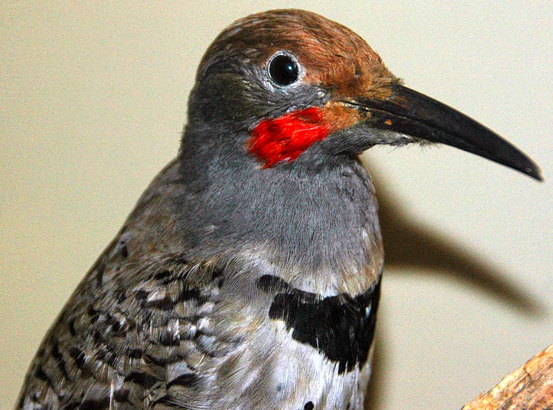
Another significant finding is that the ancestor of most of the land birds we see today is probably an apex predator that gave rise to raptors, eagles, owls and falcons in rapid succession before leading to land birds such as songbirds and woodpeckers.
“With the demise of the dinosaurs, birds and mammals were able to become more diverse and to occupy all of the niches that had previously been dominated by dinosaurs,” said Associate Professor Simon Ho.
“This was one of the most significant episodes in the history of life on earth and it is tremendously exciting that this major scientific international effort has made these advances in our understanding,” said Associate Professor Simon Ho.
Birds are evolutionarily derived from theropod dinosaurs. Credit: Image courtesy of University of California – Riverside
The absence of teeth or “edentulism” has evolved on multiple occasions within vertebrates including birds, turtles, and a few groups of mammals such as anteaters, baleen whales and pangolins. Where early birds are concerned, the fossil record is fragmentary. A question that has intrigued biologists is: Based on this fossil record, were teeth lost in the common ancestor of all living birds or convergently in two or more independent lineages of birds?
A research team led by biologists at the University of California, Riverside and Montclair State University, NJ, has found an answer. Using the degraded remnants of tooth genes in birds to determine when birds lost their teeth, the team reports in the Dec. 12 issue of Science that teeth were lost in the common ancestor of all living birds more than 100 million years ago.
“One of the larger lessons of our finding is that ‘dead genes,’ like the remnants of dead organisms that are preserved in the fossil record, have a story to tell,” said Mark Springer, a professor of biology and one of the lead authors of the study along with Robert Meredith at Montclair State University who was previously a graduate student and postdoctoral researcher in Springer’s laboratory. “DNA from the crypt is a powerful tool for unlocking secrets of evolutionary history.”
Springer explained that edentulism and the presence of a horny beak are hallmark features of modern birds.
“Ever since the discovery of the fossil bird Archaeopteryx in 1861, it has been clear that living birds are descended from toothed ancestors,” he said. “However, the history of tooth loss in the ancestry of modern birds has remained elusive for more than 150 years.”
All toothless/enamelless vertebrates are descended from an ancestor with enamel-capped teeth. In the case of birds, it is theropod dinosaurs. Modern birds use a horny beak instead of teeth, and part of their digestive tract to grind up and process food.
Tooth formation in vertebrates is a complicated process that involves many different genes. Of these genes, six are essential for the proper formation of dentin (DSPP) and enamel (AMTN, AMBN, ENAM, AMELX, MMP20).
The researchers examined these six genes in the genomes of 48 bird species, which represent nearly all living bird orders, for the presence of inactivating mutations that are shared by all 48 birds. The presence of such shared mutations in dentin and enamel-related genes would suggest a single loss of mineralized teeth in the common ancestor of all living birds.
Springer, Meredith, and other members of their team found that the 48 bird species share inactivating mutations in both dentin-related (DSPP) and enamel-related genes (ENAM, AMELX, AMTN, MMP20), indicating that the genetic machinery necessary for tooth formation was lost in the common ancestor of all modern birds.
“The presence of several inactivating mutations that are shared by all 48 bird species suggests that the outer enamel covering of teeth was lost around ~116 million years ago,” Springer said.
On the basis of fossil and molecular evidence, the researchers propose a two-step scenario whereby tooth loss and beak development evolved together in the common ancestor of all modern birds. In the first stage, tooth loss and partial beak development began on the anterior portion of both the upper and lower jaws. The second stage involved concurrent progression of tooth loss and beak development from the anterior portion of both jaws to the back of the rostrum.
“We propose that this progression ultimately resulted in a complete horny beak that effectively replaced the teeth and may have contributed to the diversification of living birds,” Springer said.
The research team also examined the genomes of additional toothless/enamelless vertebrates including three turtles and four mammals (pangolin, aardvark, sloth, and armadillo) for inactivating mutations in the dentin- and enamel-related genes. For comparison, the researchers looked at the genomes of mammalian taxa with enamel-capped teeth.
“All edentulous vertebrate genomes that we examined are characterized by inactivating mutations in DSPP, AMBN, AMELX, AMTN, ENAM, and MMP20, rendering these genes non-functional,” Springer said. “The dentin-related gene DSPP is functional in vertebrates with enamelless teeth — sloth, aardvark, armadillo. All six genes are functional in the American alligator, a representative of Crocodylia, the closest living relatives of birds, and mammalian taxa with enamel capped teeth.”
The research was supported, in part, by a grant to Springer from the National Science Foundation.
Springer and Meredith were joined in the research by Guojie Zhang at China National GeneBank, China; M. Thomas P. Gilbert at the University of Copenhagen Oster Voldgade, Denmark; and Erich D. Jarvis at Duke University Medical Center, NC.
All the scientists are coauthors with several others, including UC Riverside biologist John Gatesy, on a second paper in the same issue of Science. This paper employs the same 48 bird genomes to ask the question: “What makes a bird a bird?”
“The new bird genomes represent a major advance given that only a handful of bird genomes — zebra finch, turkey, chicken and duck — were previously available,” Springer said.
Reference:
R. W. Meredith, G. Zhang, M. T. P. Gilbert, E. D. Jarvis, M. S. Springer. Evidence for a single loss of mineralized teeth in the common avian ancestor. Science, 2014; 346 (6215): 1254390 DOI: 10.1126/science.1254390
Note : The above story is based on materials provided by University of California – Riverside. The original article was written by Iqbal Pittalwala.
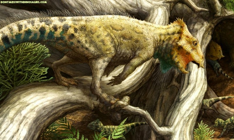
This is a an artist’s reconstruction of Aquilops in its environment in ancient Montana Credit: Copyright Brian Engh, courtesy of Raymond M. Alf Museum of Paleontology; CC-BY
Scientists have named the first definite horned dinosaur species from the Early Cretaceous in North America, according to a study published December 10, 2014 in the open-access journal PLOS ONE by Andrew Farke from Raymond M. Alf Museum of Paleontology and colleagues.
The limited fossil record for neoceratopsian–or horned dinosaurs–from the Early Cretaceous in North America restricts scientists’ ability to reconstruct the early evolution of this group. The authors of this study have discovered a dinosaur skull in Montana that represents the first horned dinosaur from the North American Early Cretaceous that they can identify to the species level. The authors named the dinosaur Aquilops americanus, which exhibits definitive neoceratopsian features and is closely related to similar species in Asia. The skull is comparatively small, measuring 84 mm long, and is distinguished by several features, including a strongly hooked rostral bone, or beak-like structure, and an elongated and sharply pointed cavity over the cheek region. When alive, the authors estimate it was about the size of a crow.
This discovery, combined with neoceratopsian fossil records from elsewhere, allows the authors to support a late Early Cretaceous (~113-105 million years ago) intercontinental migratory event between Asia and North America, as well as support for a complex set of migratory events for organisms between North America and Asia later in the Cretaceous. However, to better reconstruct the timing and mode of these events, additional fieldwork will be necessary.
“Aquilops lived nearly 20 million years before the next oldest horned dinosaur named from North America,” said Andrew Farke. “Even so, we were surprised that it was more closely related to Asian animals than those from North America.”
Reference:
Andrew A. Farke, W. Desmond Maxwell, Richard L. Cifelli, Mathew J. Wedel. A Ceratopsian Dinosaur from the Lower Cretaceous of Western North America, and the Biogeography of Neoceratopsia. PLoS ONE, 2014; 9 (12): e112055 DOI: 10.1371/journal.pone.0112055
Note : The above story is based on materials provided by PLOS.
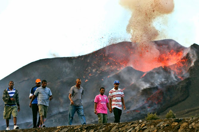
Many villagers will have little to return to. Credit: Joao Relvas/EPA
Around 60 volcanoes erupt in the average year. On any particular day, there are usually about 20 volcanoes erupting somewhere in the world. Naturally, they can’t all make headlines. But when there are human tragedies involved, we need to question the priorities of the news media.
Contrast the fuss about eruption warnings in Iceland with the vanishingly low media profile of the current eruption on Fogo, one of the islands in the Cape Verde archipelago off the coast of West Africa.
In Iceland, great fears of an ash cloud eruption that could down or ground aircraft subsided as the magma broke surface beyond the ice and fed a large and spectacular but pretty harmless fissure eruption across a remote and uninhabited region.
On the other hand, since Fogo’s eruption began on November 23 it has so far destroyed two villages and the homes of more than 1,000 people.
Cape Verde became independent from Portugal in 1975 and Fogo is home to some 37,000 inhabitants. A previous eruption on the island in 1995 covered six square kilometres with lava. The current eruption has been even more voluminous, sending lava bulldozing its way through two whole villages.
There have been limited reports on the BBC’s Africa news website. But I became aware only through social media when I noticed comments along the lines: “Hey – why haven’t we seen this on the news?”. If the Cape Verde islands had remained an overseas province of Portugal, like the Azores, perhaps in the developed world we would have heard more about what’s been going on there. Instead, although the unfolding events on Fogo are being well-documented by local media, they don’t seem to make it into news stories featured outside of Africa.
Fogo erupts mostly a slow-moving form of basalt lava that humans and animals can easily evade. However, its advance is inexorable and there’s nothing that can be done to stop it. Even in much-wealthier Hawaii, where the town of Pahoa is currently threatened by advancing lava, a diversion attempt is unlikely.
On Fogo, locals have had time to escape with their movable possessions. They have then sat on higher ground to watch while their homes, schools and agricultural small-holdings are slowly destroyed. Drinking water in the surrounding area is contaminated by volcanic ash, and has been declared unfit for human or animal consumption.
Unlike in 1995, when the evacuated population were able to return to their homes, this time there is nothing to return to. It’s incredibly sad, and has been well-documented on professional and amateur video, but it seems that news editors in the developed world don’t deem it newsworthy. Is it just because nobody died, and because so far the locally-organised evacuation centres have been able to cope?
These people have lost their homes and their livelihoods. Does Ebola on mainland Africa and a typhoon in the Philippines mean that there really is no time for an event such as this in our mainstream news agenda? Or do we care about volcanoes only if there’s a chance of them inconveniencing our air-travel plans?
The unfolding events on Fogo can be followed (in Portuguese) at Fogo News and in English at Earthquake Report. There’s also the GEOVOL group that is active on Facebook.
Note : The above story is based on materials provided by The Conversation This story is published courtesy of The Conversation (under Creative Commons-Attribution/No derivatives).
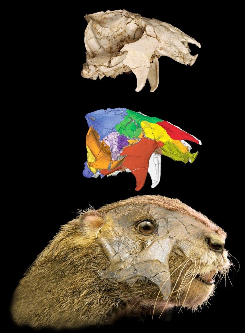
Top: Right lateral (side) view of the actual specimen of Vintana sertichi. Middle: Digitally segmented version of the skull, with individual bones highlighted in unique colors. Bottom: Reconstruction of the head. Credit: Journal of Vertebrate Paleontology
Mammals that lived during the time of the dinosaurs are often portrayed as innocuous, small-bodied creatures, scurrying under the feet of the huge reptiles. In reality, this wasn’t the case, and a new fossil from Madagascar further underscores this point, revealing fascinating perspectives on the growing diversity of Mesozoic mammals.
Vintana sertichi had previously been described in a preliminary note in November of this year, but a new memoir in the Journal of Vertebrate Paleontology delves far deeper into the morphology and paleoecology of this amazing fossil animal. The memoir brings together multiple experts to conduct a range of descriptive and comparative analyses and consists of multiple papers describing the geological setting of the fossil, its cranial anatomy, its dental morphology and function, its braincase, and its sensory abilities.
David W. Krause of Stony Brook University, the editor of the volume and lead investigator on the project, says, “From an organizational perspective, there are two things about this monograph with which I am particularly delighted. First, that I was fortunate enough to be able to assemble such an outstandingly capable mix of specialists, students, and technicians to focus their attention on this amazing specimen. Second, the emphasis on micro-CT imaging, and the thousands of hours spent on digital segmentation of each cranial element, was instrumental in allowing us to describe and understand the detailed internal anatomy of the cranium of this bizarre mammal.”
Vintana is a member of an extinct and, until now, very poorly known group of mammals, the gondwanatherians, which are named based on their geographic distribution on the southern continents, also known as Gondwana. Previously known fossils of gondwanatherians had consisted only of isolated teeth and a few fragmentary lower jaw specimens. The new specimen is a nearly complete and only slightly distorted cranium, which was painstakingly removed from a large block of sediment and later micro-CT scanned to provide fine details of both the external and internal anatomy of the animal. These scans also allowed the investigators to digitally separate, or segment, individual cranial bones and allowed them to virtually dissect the specimen without actually destroying it.
Krause says, “We hope that the memoir will serve as a useful reference for all future discoveries and analyses of gondwanatherian mammals represented by craniodental material.”
The cranium displays some bizarre features, like enlarged flanges for attachment of chewing muscles, a strangely tilted braincase, and large eye sockets. Analysis of these features and others reveals that Vintana was a badger-sized, herbivorous animal that was agile and active, with keen senses of smell, vision, and hearing. John Wible, of the Carnegie Museum in Pittsburgh and one of the experts on the investigation who analyzed the skull and ear region of the fossil, says “With this monograph, the shroud of mystery over the enigmatic, extinct mammal clade Gondwanatheria is lifted. Through CT scans, the amazingly preserved skull of Vintana sertichi is dissected, described, and reconstructed. The authors breathe life into this fossil by reconstructing its brain, inner ear, jaw musculature, orbit, and nasal cavity, and set the bar high for how such studies will be done in the future.”
Reference:
Simone Hoffmann, Patrick M. O’Connor, E. Christopher Kirk, John R. Wible, David W. Krause. Endocranial and Inner Ear Morphology of Vintana Sertichi (Mammalia, Gondwanatheria) from the Late Cretaceous of Madagascar. Journal of Vertebrate Paleontology, 2014; 34 (sup1): 110 DOI: 10.1080/02724634.2014.956878
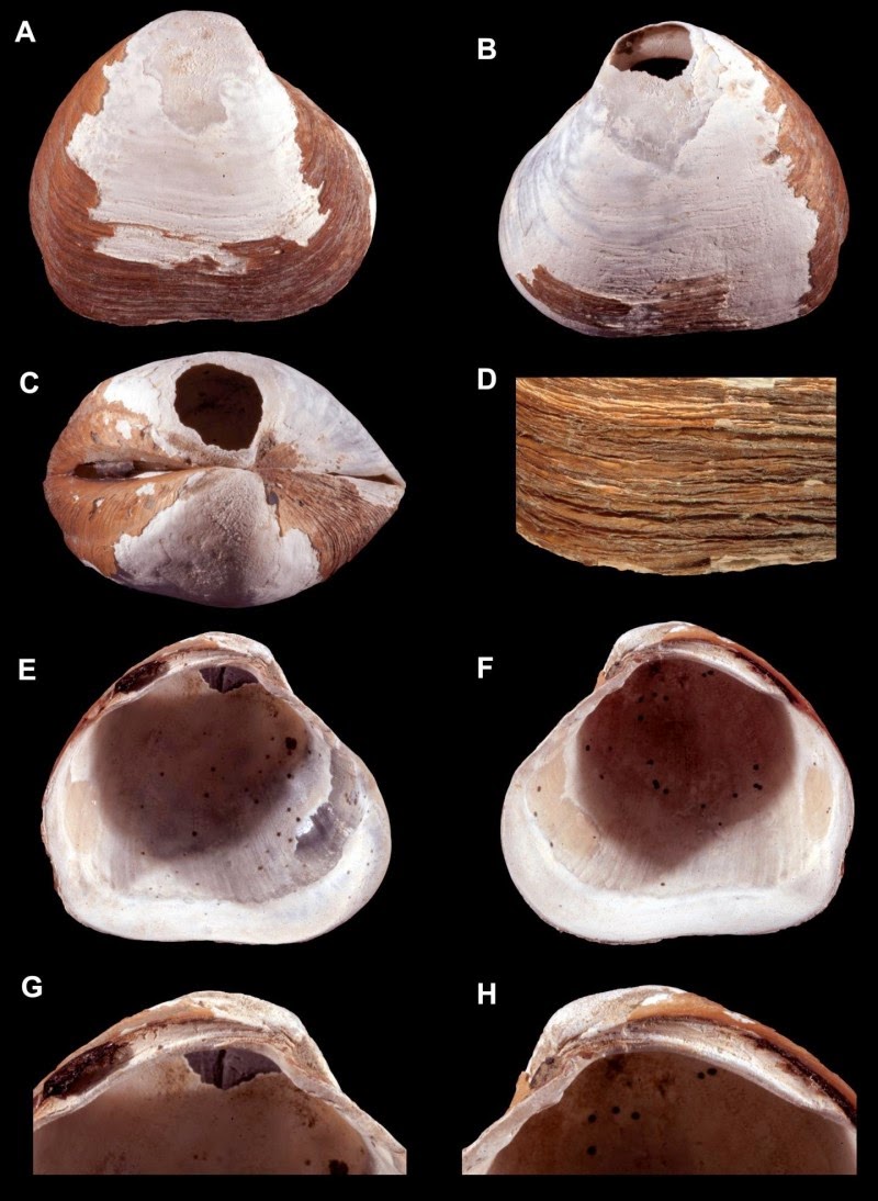
This image shows the new species of bivalve mollusk was recently described and named Wallerconcha sarae. Credit: Paul Valentich-Scott; CC-BY 4.0
In the depths of the Arctic Ocean, buried deep in the sediment, an ancient creature waited for over a million years to be discovered. Paul Valentich-Scott, from the Santa Barbara Museum of Natural History (California), and three scientists from the United States Geological Survey (USGS, Menlo Park, California), Charles L. Powell, Brian D. Edwards, and Thomas D. Lorenson were up to the challenge. Each with different expertise, they were able to collect, analyze, and identify a new genus and new species of bivalve mollusk.
The path to discovery is seldom simple or easy. This discovery is no exception. Brian Edwards was the chief scientist on a joint US-Canadian ice breaker expedition aboard the US Coast Guard Cutter Healy in the summer of 2010. The primary purpose of the expedition was to map the Arctic seafloor and the sediments beneath. Dr. Edwards took deep sediment core samples to further understand the geology of the region including the unusual seafloor mound where these samples were collected. In several of these cores he uncovered bivalve seashells buried nearly 15 feet (4.5 m) below the seafloor surface.
Upon returning to his USGS laboratory in Menlo Park, California, Brian worked with Tom Lorenson on sampling the cores and extracting the shells. The recovered shells were then taken to USGS paleontologist Chuck Powell, for identification. While Chuck was able to ascertain the higher level classification of the clam shells (Family Thyasiridae), he was unable to determine the genus or species. Chuck contacted Paul Valentich-Scott, a clam specialist from the Santa Barbara Museum of Natural History in California.
When examining these ancient shell specimens, Paul was fairly certain that they were new to science. The hunt to validate the potential new species was on. Paul contacted a number of thyasirid bivalve specialists around the world and all gave it a thumbs up as a new species. Further, several scientists felt it also might be a new genus (the level above species).
‘It is always exciting when you are the first person to be looking at a new creature’ declared Valentich-Scott. ‘While I have been fortunate to discover and describe many new species in my career, it is always exhilarating at the outset.’
Then the painstaking work began. Paul contacted museums around the globe and requested to borrow specimens that were potentially related to the new species. While he found many species that shared some characteristics, none matched the new Arctic specimens.
The four scientists have been writing up their findings for the past two years and now the work has been published in the international science journal ZooKeys.
The new genus and species is named after two individuals. The genus is named in honor of Dr. Thomas R. Waller a prominent paleontologist at the Smithsonian Institution. The suffix “concha” meaning shell, is combined to create the name Wallerconcha. The new species is named after Sara Powell the daughter of co-author Chuck Powell. Chuck was quick to mention “I want to name new species after all of my children.”
While many of the specimens collected were definitely fossils, the scientists can’t discount the new animal might still be alive today. One of the team members, Tom Lorenson, summarized it this way ‘The likely collection of living specimens of this species awaits expeditions to come.’ Who knows what other new creatures might be found in those expeditions?
Reference:
Paul Valentich-Scott, Charles Powell, Thomas Lorenson, Brian Ewards. A new genus and species of Thyasiridae (Mollusca, Bivalvia) from deep-water, Beaufort Sea, northern Alaska. ZooKeys, 2014; 462: 11 DOI: 10.3897/zookeys.462.6790
Note : The above story is based on materials provided by Pensoft Publishers. The original story is licensed under a Creative Commons License.
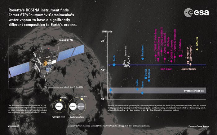
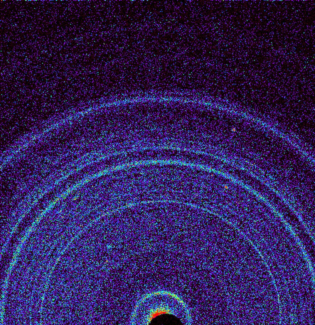
First measurements of comet’s water ratio. Credit: Copyright Spacecraft: ESA/ATG medialab; Comet: ESA/Rosetta/NavCam; Data: Altwegg et al. 2014
ESA’s Rosetta spacecraft has found the water vapour from its target comet to be significantly different to that found on Earth. The discovery fuels the debate on the origin of our planet’s oceans.
The measurements were made in the month following the spacecraft’s arrival at Comet 67P/Churyumov-Gerasimenko on 6 August. It is one of the most anticipated early results of the mission, because the origin of Earth’s water is still an open question.
One of the leading hypotheses on Earth’s formation is that it was so hot when it formed 4.6 billion years ago that any original water content should have boiled off. But, today, two thirds of the surface is covered in water, so where did it come from?
In this scenario, it should have been delivered after our planet had cooled down, most likely from collisions with comets and asteroids. The relative contribution of each class of object to our planet’s water supply is, however, still debated.
The key to determining where the water originated is in its ‘flavour’, in this case the proportion of deuterium — a form of hydrogen with an additional neutron — to normal hydrogen.
This proportion is an important indicator of the formation and early evolution of the Solar System, with theoretical simulations showing that it should change with distance from the Sun and with time in the first few million years.
One key goal is to compare the value for different kinds of object with that measured for Earth’s oceans, in order to determine how much each type of object may have contributed to Earth’s water.
Comets in particular are unique tools for probing the early Solar System: they harbour material left over from the protoplanetary disc out of which the planets formed, and therefore should reflect the primordial composition of their places of origin.
But thanks to the dynamics of the early Solar System, this is not a straightforward process. Long-period comets that hail from the distant Oort cloud originally formed in Uranus-Neptune region, far enough from the Sun that water ice could survive.
They were later scattered to the Solar System’s far outer reaches as a result of gravitational interactions with the gas giant planets as they settled in their orbits.
Conversely, Jupiter-family comets like Rosetta’s comet were thought to have formed further out, in the Kuiper Belt beyond Neptune. Occasionally these bodies are disrupted from this location and sent towards the inner Solar System, where their orbits become controlled by the gravitational influence of Jupiter.
Indeed, Rosetta’s comet now travels around the Sun between the orbits of Earth and Mars at its closest and just beyond Jupiter at its furthest, with a period of about 6.5 years.
Previous measurements of the deuterium/hydrogen (D/H) ratio in other comets have shown a wide range of values. Of the 11 comets for which measurements have been made, it is only the Jupiter-family Comet 103P/Hartley 2 that was found to match the composition of Earth’s water, in observations made by ESA’s Herschel mission in 2011.
By contrast, meteorites originally hailing from asteroids in the Asteroid Belt also match the composition of Earth’s water. Thus, despite the fact that asteroids have a much lower overall water content, impacts by a large number of them could still have resulted in Earth’s oceans.
It is against this backdrop that Rosetta’s investigations are important. Interestingly, the D/H ratio measured by the Rosetta Orbiter Spectrometer for Ion and Neutral Analysis, or ROSINA, is more than three times greater than for Earth’s oceans and for its Jupiter-family companion, Comet Hartley 2. Indeed, it is even higher than measured for any Oort cloud comet as well.
“This surprising finding could indicate a diverse origin for the Jupiter-family comets — perhaps they formed over a wider range of distances in the young Solar System than we previously thought,” says Kathrin Altwegg, principal investigator for ROSINA and lead author of the paper reporting the results in the journal Science this week.
“Our finding also rules out the idea that Jupiter-family comets contain solely Earth ocean-like water, and adds weight to models that place more emphasis on asteroids as the main delivery mechanism for Earth’s oceans.”
“We knew that Rosetta’s in situ analysis of this comet was always going to throw up surprises for the bigger picture of Solar System science, and this outstanding observation certainly adds fuel to the debate about the origin of Earth’s water,” says Matt Taylor, ESA’s Rosetta project scientist.
“As Rosetta continues to follow the comet on its orbit around the Sun throughout next year, we’ll be keeping a close watch on how it evolves and behaves, which will give us unique insight into the mysterious world of comets and their contribution to our understanding of the evolution of the Solar System.”
Reference:
K. Altwegg, H. Balsiger, A. Bar-Nun, J. J. Berthelier, A. Bieler, P. Bochsler, C. Briois, U. Calmonte, M. Combi, J. De Keyser, P. Eberhardt, B. Fiethe, S. Fuselier, S. Gasc, T. I. Gombosi, K.C. Hansen, M. Hässig, A. Jäckel, E. Kopp, A. Korth, L. LeRoy, U. Mall, B. Marty, O. Mousis, E. Neefs, T. Owen, H. Rème, M. Rubin, T. Sémon, C.-Y. Tzou, H. Waite, and P. Wurz. 67P/Churyumov-Gerasimenko, a Jupiter family comet with a high D/H ratio. Science, 10 December 2014 DOI: 10.1126/science.1261952
Note : The above story is based on materials provided by ESA.
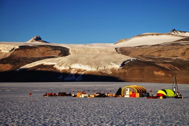
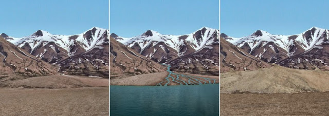
Researchers measured increases in atmospheric nitrous oxide concentrations about 16,000 to 10,000 years ago using ice from Taylor Glacier in Antarctica. Credit: Adrian Schilt
Nitrous oxide (N2O) is an important greenhouse gas that doesn’t receive as much notoriety as carbon dioxide or methane, but a new study confirms that atmospheric levels of N2O rose significantly as the Earth came out of the last ice age and addresses the cause.
An international team of scientists analyzed air extracted from bubbles enclosed in ancient polar ice from Taylor Glacier in Antarctica, allowing for the reconstruction of the past atmospheric composition. The analysis documented a 30 percent increase in atmospheric nitrous oxide concentrations from 16,000 years ago to 10,000 years ago. This rise in N2O was caused by changes in environmental conditions in the ocean and on land, scientists say, and contributed to the warming at the end of the ice age and the melting of large ice sheets that then existed.
The findings add an important new element to studies of how Earth may respond to a warming climate in the future. Results of the study, which was funded by the U.S. National Science Foundation and the Swiss National Science Foundation, are being published this week in the journal Nature.
“We found that marine and terrestrial sources contributed about equally to the overall increase of nitrous oxide concentrations and generally evolved in parallel at the end of the last ice age,” said lead author Adrian Schilt, who did much of the work as a post-doctoral researcher at Oregon State University. Schilt then continued to work on the study at the Oeschger Centre for Climate Change Research at the University of Bern in Switzerland.
“The end of the last ice age represents a partial analog to modern warming and allows us to study the response of natural nitrous oxide emissions to changing environmental conditions,” Schilt added. “This will allow us to better understand what might happen in the future.”
Nitrous oxide is perhaps best known as laughing gas, but it is also produced by microbes on land and in the ocean in processes that occur naturally, but can be enhanced by human activity. Marine nitrous oxide production is linked closely to low oxygen conditions in the upper ocean and global warming is predicted to intensify the low-oxygen zones in many of the world’s ocean basins. N2O also destroys ozone in the stratosphere.
“Warming makes terrestrial microbes produce more nitrous oxide,” noted co-author Edward Brook, an Oregon State paleoclimatologist whose research team included Schilt. “Greenhouse gases go up and down over time, and we’d like to know more about why that happens and how it affects climate.”
Nitrous oxide is among the most difficult greenhouse gases to study in attempting to reconstruct Earth’s climate history through ice core analysis. The specific technique that the Oregon State research team used requires large samples of pristine ice that date back to the desired time of study — in this case, between about 16,000 and 10,000 years ago.
The unusual way in which Taylor Glacier is configured allowed the scientists to extract ice samples from the surface of the glacier instead of drilling deep in the polar ice cap because older ice is transported upward near the glacier margins, said Brook, a professor in Oregon State’s College of Earth, Ocean, and Atmospheric Sciences.
The scientists were able to discern the contributions of marine and terrestrial nitrous oxide through analysis of isotopic ratios, which fingerprint the different sources of N2O in the atmosphere.
“The scientific community knew roughly what the N2O concentration trends were prior to this study,” Brook said, “but these findings confirm that and provide more exact details about changes in sources. As nitrous oxide in the atmosphere continues to increase — along with carbon dioxide and methane — we now will be able to more accurately assess where those contributions are coming from and the rate of the increase.”
Atmospheric N2O was roughly 200 parts per billion at the peak of the ice age about 20,000 years ago then rose to 260 ppb by 10,000 years ago. As of 2014, atmospheric N2Owas measured at about 327 ppb, an increase attributed primarily to agricultural influences.
Although the N2O increase at the end of the last ice age was almost equally attributable to marine and terrestrial sources, the scientists say, there were some differences.
“Our data showed that terrestrial emissions changed faster than marine emissions, which was highlighted by a fast increase of emissions on land that preceded the increase in marine emissions,” Schilt pointed out. “It appears to be a direct response to a rapid temperature change between 15,000 and 14,000 years ago.”
That finding underscores the complexity of analyzing how Earth responds to changing conditions that have to account for marine and terrestrial influences; natural variability; the influence of different greenhouse gases; and a host of other factors, Brook said.
“Natural sources of N2O are predicted to increase in the future and this study will help up test predictions on how the Earth will respond,” Brook said.
Reference:
Adrian Schilt, Edward J. Brook, Thomas K. Bauska, Daniel Baggenstos, Hubertus Fischer, Fortunat Joos, Vasilii V. Petrenko, Hinrich Schaefer, Jochen Schmitt, Jeffrey P. Severinghaus, Renato Spahni, Thomas F. Stocker. Isotopic constraints on marine and terrestrial N2O emissions during the last deglaciation. Nature, 2014; 516 (7530): 234 DOI: 10.1038/nature13971
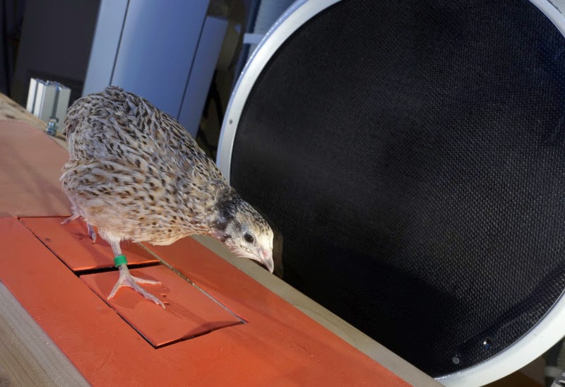
The motion scientists from Jena University had quails walking through a high speed X-ray installation and measured the power at work in their legs. Credit: Jan-Peter Kasper/FSU
Motion scientists and zoologists at Jena University are studying the gait of birds. In the Proceedings of the Royal Society B the team published the first detailed analysis of the bipedal gait of quails. The scientists analyzed the effect of the birds’ posture on the movement of their legs and on their stability when they walk.
Dinosaurs did it. Human beings and monkey do it. And even birds do it. They walk on two legs. And although humans occupy a special position amongst mammals as they have two legs, the upright gait is not reserved only for humans. In the course of evolution many animals have developed the bipedal gait — the ability to walk on two legs.
“Birds are moving forward on two legs as well, although they use a completely different technique from us humans,” Dr. Emanuel Andrada from the Friedrich Schiller University in Jena (Germany) says. Human beings keep their upper bodies generally in an upright position and the body’s center of gravity is directly above the legs. The bodies of birds on the other hand are horizontally forward-facing, which appears to be awkward at first glance. Hence the motion scientist analyzed — together with colleagues — which effect this posture has on the movement of their legs and on their stability when they walk.
To this end the team had quails walking through a high speed X-ray installation at varying speeds. While the installation monitored the movements of the animals meticulously, the scientists were able to measure the power at work in their legs. From this data, the Jena research team could develop a computer model of the whole motion sequence, which served to simulate and analyze the stability and the energy balance in connection to different gaits.
As it turned out, the birds use the so-called “grounded running” style when they move quickly — this is a running style in which at least one leg is always touching the ground. “Even when running quickly, short periods of flight phases occur only very rarely between the individual steps,” Prof. Dr. Reinhard Blickhan, Chair of Motion Science at Jena University explains. But this is extremely energy consuming for the animals because the body’s center of gravity lies distinctly in front of their legs — due to the horizontal posture. “The animals have to constantly balance out their own bodies in order to prevent falling forwards,” says Blickhan.
But this huge effort is worthwhile as the researchers discovered with the help of their computer model. “Unlike the legs of humans which gather energy like two coil springs and use it directly to move forwards, the bird’s legs work in addition like dampers or shock absorbers.” In order to prevent falling forwards or to permanently accelerate their movement, the birds practically have to brake all the time. This happens while the bird leg is working like a spring damper: Energy is withdrawn from the leg, but the amount of energy is the same that was invested in the hip to stabilize the trunk via the turning moment.
“This apparent wasting of energy is the price for a very stable posture during locomotion, especially on an uneven terrain,” Blickhan summarizes the result of this study.
After these newly presented results, the Jena researchers anticipate interesting times ahead. They also want to test the gait of other birds with the help of the computer model they developed. And the scientists even want to analyze the locomotion of dinosaurs — the direct forebears of today’s birds. “It is not clear yet how two-legged species like Allosaurus or Tyrannosaurus Rex really moved forward,” says Dr. Andrada. But it is assumed by now that they also ran with their upper bodies thrust forwards horizontally — due to biomechanical advantages.
Reference:
E. Andrada, C. Rode, Y. Sutedja, J. A. Nyakatura, R. Blickhan. Trunk orientation causes asymmetries in leg function in small bird terrestrial locomotion. Proceedings of the Royal Society B: Biological Sciences, 2014; 281 (1797): 20141405 DOI: 10.1098/rspb.2014.1405
There’s nothing subtle about the story told by the rocks in northern Italy’s Sesia Valley. Evidence of ancient volcanic activity is all around, says geologist and volcanologist James Quick, Southern Methodist University, Dallas.
But the full story is much less obvious, Quick notes.
Quick led an international team that in 2009 announced they had discovered a 282-million-year-old fossil supervolcano in Sesia Valley. The find was the result of nearly two decades of geological research in the valley and its surrounding mountains.
The discovery has attracted scientific attention worldwide for its unprecedented view of a supervolcano’s internal plumbing to a depth of 15.5 miles.
But that’s not the end of the story—rather the beginning, says Quick, a professor in SMU’s Roy M. Huffington Department of Earth Sciences in Dedman College of Humanities and Sciences.
The supervolcano holds clues—and ultimately answers—to critical scientific questions about the processes by which volcanoes erupt.
“I am certain that continued study of this unique geologic exposure will reveal significant insight into the operation of active supervolcanoes,” he says.
There are six active supervolcanoes in the world, including Yellowstone, Long Valley and Valles in the United States.
Volcanic plumbing, normally hidden from examination deep within the earth, is the internal geological structure through which lava migrates from the earth’s mantle, up through the crust, to ultimately explode.
Volcanic plumbing and the processes within it remain matters of speculation, as volcanologists explore how lava forms and traverses through the earth.
News of a supervolcano initially sparked alarm
Supervolcanoes are one of the most potentially violent events in the world. They erupt hundreds of cubic miles of lava and ash, and have caused catastrophic changes in global climate.
Sesia Valley’s supervolcano last erupted 282 million years ago, when it erupted more than 186 cubic miles of molten rock, ash and gas.
The discovery by Quick and scientists from the University of Trieste made headlines worldwide in 2009. Sesia Valley residents were alarmed.
“They held a big town meeting in the largest of the communities, Borgosesia, and more than 500 people came from all over the valley,” Quick says. “People were extremely worried the volcano would erupt again.”
The scientists reassured residents they had nothing to fear. A fossil, the supervolcano no longer poses a danger.
Supervolcano is a super attraction for its scientifically unique features
Now its rocks are a popular destination for scientists, college students, villagers, tourists and school groups. Proud residents enthusiastically brand many of the valley’s events and activities with their supervolcano identity.
Even acclaimed Italian winemaker Cantalupo in 2013 honored the unique volcanic origins of its Sesia Valley grapes by labeling its Christmas wine with a painting of the exploding supervolcano.
The supervolcano also is a central feature of the new Sesia-Val Grande Geopark, recently designated by the U.N.’s UNESCO agency.
Residents of the Piedmont region’s Sesia Valley, with diverse history and cultures, joined forces after the discovery was announced to pursue the coveted UNESCO geopark status. One of only 100 geoparks in the world, Sesia-Val Grande Geopark spans tens of thousands of acres and more than 80 Alpine communities.
Chaotic riverbed blocks are key to solving volcanic rock puzzle
Rock strata of the Sesia Valley supervolcano are exposed along the banks of the Sesia River for 22 miles, sitting sideways like a tipped-over layer cake. In some places, the rocks protrude haphazardly from the sides of mountains; in other places they are obscured beneath dense forest, roads, bustling villages, fields and pastures, outdoor sports locales and tourist destinations.
Some of the supervolcano’s deepest sections serve as a backdrop for Varallo, one of many communities in the Alpine valley.
Granite boulders littering the bed of the Sesia River were formed in the supervolcano’s magma chamber.
Atop a hill overlooking Varallo, more than 40 chapels of the 15th century world-famous monumental religious complex Sacro Monte di Varallo were built on the furnace that powered the volcanic system.
So how did an entire valley not see an ancient fossil supervolcano until now?
Like an ant looking at an elephant, it’s difficult to see something so gigantic for what it really is. In the United States, for example, it’s only in about the last 30 years that geologists deciphered that Yellowstone is a supervolcano.
Scientists have known for more than a century, however, about the presence of volcanic rocks in Sesia Valley.
That’s what drew Quick to the area in 1989. He sought insight into the processes in the deep crust that influence eruptions. What Quick found kept him coming back every summer for 16 years, including as head of the Volcano Hazards Program for the U.S. Geological Survey.
Quick’s quest made him the first scientist in more than 50 years—building on the work of Italian geologist Mario Bertolani before World War II—to methodically tramp every mile of the steep mountainsides, sometimes with colleagues, often alone, to extensively identify and map the valley’s rocks.
Years of intrepid geological work yield a supervolcano hiding in plain sight
Quick endured pounding rain, fierce lightning, poisonous snakes, mosquitos, treacherous topography, slippery waterfalls and unexpected sheer drop-offs. More than once he feared for his life.
“Working in the mountains there I was frequently terrified,” Quick said recently, during one of his frequent treks to the valley. “I’d wonder, is this the next traverse that claims my life? I had many frightening experiences. The vegetation looks thick, but underneath the canopy it’s easy to walk, except there are lots of cliffs hidden by the trees. Another problem—locating your position; because you can’t look out and see the topography. We started this before GPS, doing it old school, by triangulation, reading the map, carefully locating where we were, and using altimeters.”
Summer 2005 brought an unexpected breakthrough.
Quick was invited by his Italian colleague to see some puzzling rocks in the riverbed of the Sesia River in hopes he could identify them. Upon seeing the chaotic assemblage, Quick recognized the rocks were gigantic blocks torn from the rim of the volcano and mixed with volcanic ash during the eruption—an assemblage geologists call a megabreccia.
In 2009, following additional work to confirm the discovery, Quick and his team announced their discovery in the scientific journal “Geology.” They estimated the mouth of the volcano when it was active would have been at least eight miles in diameter, although its true size will never be known because much of it is covered by younger sedimentary deposits of the Po Plain.
Fossil supervolcano sits against ancient boundary separating Africa, Europe
In its youth, Sesia Valley’s supervolcano was inland on the supercontinent of Pangea. When Pangea began to break up into smaller continents more than 200 million years ago, the supervolcano was stranded on the coast of what we now call Africa.
About 20 million years ago, another tectonic shift sent Africa colliding into southern Europe. The coastal edges of both continents were heaved upward, creating a massive uplift – the Alps.
The Sesia Valley supervolcano, in the process, was tilted sideways and shoved upward, exposing its plumbing.
Today the supervolcano is a mecca for geologists not only for its volcanic story, but as one of the best samples of the earth’s mantle exposed at the surface.
Calling it the “Rosetta Stone” of supervolcanoes, Quick says the Sesia Valley fossil supervolcano ultimately could solve the mystery, “How does magma build up in the crust in the run up to a supereruption?”
Quick honored for scientific achievements
In 2010 the Italian Geological Society awarded Quick the Capellini Medal, presented to foreign geoscientists for a significant contribution to Italian geology.
In 2013, Quick was named a Fellow of the American Association for the Advancement of Science. Along with his Italian colleague, Silvano Sinigoi, Quick also was awarded honorary citizenship of Borgosesia, the highest award given to civilians by the largest city in the Sesia Valley.
“The discoveries in the Sesia Valley demonstrate the value of supporting basic research,” says Quick, who came to SMU in 2007 after a 25-year scientific career with USGS. Quick serves also as associate vice president for research and dean of graduate studies at SMU.
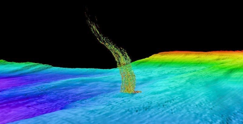
Sonar image of bubbles rising from the seafloor off the Washington coast. The base of the column is 1/3 of a mile (515 meters) deep and the top of the plume is at 1/10 of a mile (180 meters) depth. Credit: B. Philip / Univ. of Washington
Off the West Coast of the United States, methane gas is trapped in frozen layers below the seafloor. New research from the University of Washington shows that water at intermediate depths is warming enough to cause these carbon deposits to melt, releasing methane into the sediments and surrounding water.
Researchers found that water off the coast of Washington is gradually warming at a depth of 500 meters, about a third of a mile down. That is the same depth where methane transforms from a solid to a gas. The research suggests that ocean warming could be triggering the release of a powerful greenhouse gas.
“We calculate that methane equivalent in volume to the Deepwater Horizon oil spill is released every year off the Washington coast,” said Evan Solomon, a UW assistant professor of oceanography. He is co-author of a paper to appear in Geophysical Research Letters.
While scientists believe that global warming will release methane from gas hydrates worldwide, most of the current focus has been on deposits in the Arctic. This paper estimates that from 1970 to 2013, some 4 million metric tons of methane has been released from hydrate decomposition off Washington. That’s an amount each year equal to the methane from natural gas released in the 2010 Deepwater Horizon blowout off the coast of Louisiana, and 500 times the rate at which methane is naturally released from the seafloor.
“Methane hydrates are a very large and fragile reservoir of carbon that can be released if temperatures change,” Solomon said. “I was skeptical at first, but when we looked at the amounts, it’s significant.”
Methane is the main component of natural gas. At cold temperatures and high ocean pressure, it combines with water into a crystal called methane hydrate. The Pacific Northwest has unusually large deposits of methane hydrates because of its biologically productive waters and strong geologic activity. But coastlines around the world hold deposits that could be similarly vulnerable to warming.
“This is one of the first studies to look at the lower-latitude margin,” Solomon said. “We’re showing that intermediate-depth warming could be enhancing methane release.”
Co-author Una Miller, a UW oceanography undergraduate, first collected thousands of historic temperature measurements in a region off the Washington coast as part of a separate research project in the lab of co-author Paul Johnson, a UW professor of oceanography. The data revealed the unexpected sub-surface ocean warming signal.
“Even though the data was raw and pretty messy, we could see a trend,” Miller said. “It just popped out.”
The four decades of data show deeper water has, perhaps surprisingly, been warming the most due to climate change.
“A lot of the earlier studies focused on the surface because most of the data is there,” said co-author Susan Hautala, a UW associate professor of oceanography. “This depth turns out to be a sweet spot for detecting this trend.” The reason, she added, is that it lies below water nearer the surface that is influenced by long-term atmospheric cycles.
The warming water probably comes from the Sea of Okhotsk, between Russia and Japan, where surface water becomes very dense and then spreads east across the Pacific. The Sea of Okhotsk is known to have warmed over the past 50 years, and other studies have shown that the water takes a decade or two to cross the Pacific and reach the Washington coast.
“We began the collaboration when we realized this is also the most sensitive depth for methane hydrate deposits,” Hautala said. She believes the same ocean currents could be warming intermediate-depth waters from Northern California to Alaska, where frozen methane deposits are also known to exist.
Warming water causes the frozen edge of methane hydrate to move into deeper water. On land, as the air temperature warms on a frozen hillside, the snowline moves uphill. In a warming ocean, the boundary between frozen and gaseous methane would move deeper and farther offshore. Calculations in the paper show that since 1970 the Washington boundary has moved about 1 kilometer — a little more than a half-mile — farther offshore. By 2100, the boundary for solid methane would move another 1 to 3 kilometers out to sea.
Estimates for the future amount of gas released from hydrate dissociation this century are as high as 0.4 million metric tons per year off the Washington coast, or about quadruple the amount of methane from the Deepwater Horizon blowout each year.
Still unknown is where any released methane gas would end up. It could be consumed by bacteria in the seafloor sediment or in the water, where it could cause seawater in that area to become more acidic and oxygen-deprived. Some methane might also rise to the surface, where it would release into the atmosphere as a greenhouse gas, compounding the effects of climate change.
Researchers now hope to verify the calculations with new measurements. For the past few years, curious fishermen have sent UW oceanographers sonar images showing mysterious columns of bubbles. Solomon and Johnson just returned from a cruise to check out some of those sites at depths where Solomon believes they could be caused by warming water.
“Those images the fishermen sent were 100 percent accurate,” Johnson said. “Without them we would have been shooting in the dark.”
Johnson and Solomon are analyzing data from that cruise to pinpoint what’s triggering this seepage, and the fate of any released methane. The recent sightings of methane bubbles rising to the sea surface, the authors note, suggests that at least some of the seafloor gas may reach the surface and vent to the atmosphere.
Reference:
Susan L. Hautala, Evan A. Solomon, H. Paul Johnson, Robert N. Harris, Una K. Miller. Dissociation of Cascadia margin gas hydrates in response to contemporary ocean warming. Geophysical Research Letters, 2014; DOI: 10.1002/2014GL061606
Note : The above story is based on materials provided by University of Washington. The original article was written by Hannah Hickey.
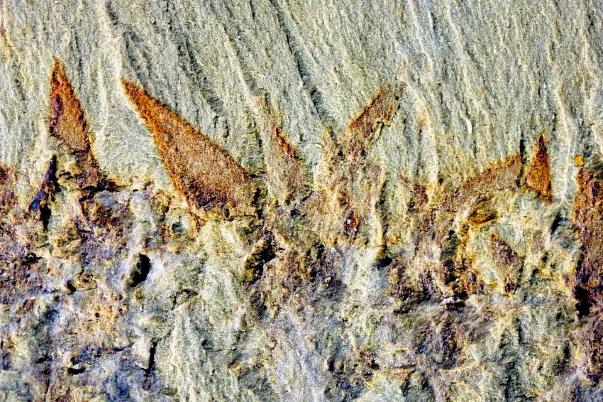
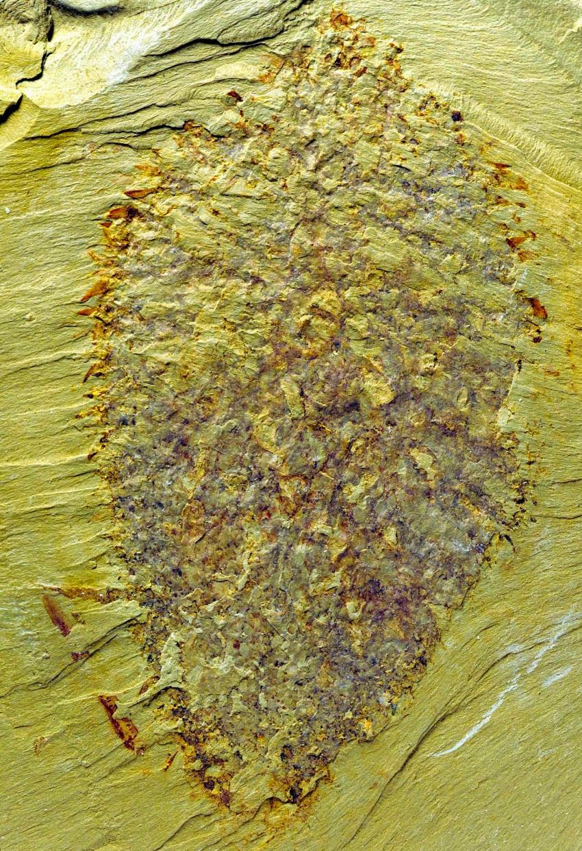
A rare 520 million year old fossil shaped like a ‘squashed bird’s nest’ that will help to shed new light on life within Earth’s ancient seas has been discovered in China by an international research team – and will honour the memory of a University of Leicester scientist who passed away earlier this year.
The research team behind the discovery was led by Professor Xianguang Hou from the Yunnan Key Laboratory for Palaeobiology at Yunnan University in China with collaboration from the Universities of Leicester and Oxford.
The fossil, from Chengjiang in southern China, is of a probable ‘chancelloriid’, a group of bizarre, balloon-shaped animals with an outer skeleton of defensive spines. The animal was flattened during the fossilisation process so that it looks like a squashed bird’s nest.
Funded by the National Science Foundation in China and the Royal Society in the UK, the research team named the species Nidelric pugio to honour the late Professor Richard Aldridge, an internationally renowned palaeontologist and keen ornithologist formerly of the University of Leicester’s Department of Geology and a scientist who was a world leader in Chengjiang fossil research.
The name of the fossil is derived from the Latin Nidus, meaning ‘bird’s nest’ or ‘fancied resemblance to’ and adelric, derived from the Old English personal name ‘Aedelic’ – ‘adel’ meaning ‘noble’ and ‘ric’ meaning ‘a ruler’- which is a source for the name Aldridge.
Dr Tom Harvey from the University of Leicester, a co-author of the paper, said: “There is only one fossil of this enigmatic animal after 30 years of collecting by our Chinese colleagues at Chengjiang. It is exceptionally rare, but it shows us just how strange and varied the shapes of early animals could be.
“We are glad the fossil can honour the name of Professor Richard Aldridge, who was a leader in this field and whose research was vital in better understanding the rich tapestry of fossils found at Chengjiang.”
In southern China, rocks 520 million years old in Chengjiang County, Yunnan Province yield a diverse array of fossils preserved with traces of their soft anatomy, including their legs, eyes, guts and even brains.
Amongst the fossils are many animals that can be related to modern forms, including distant relatives of arthropods such as crabs and lobsters, and a wide variety of worms.
There are also several enigmatic fossils that don’t seem to fit in with anything living today, and amongst these are the chancelloriids.
These fossils provide an unprecedented view of life in Earth’s ancient seas.
Tom Hearing, a PhD student from the Department of Geology who is working on the skeletons of Cambrian fossils, added: “We usually only get the broken-up remains of ancient animal skeletons. With this specimen we can see how all the different parts of the skeleton stuck together. It tells us much about how early animals functioned, how they might have interacted with other animals, and how they might have protected themselves from predators.”
Reference:
The paper, ‘A chancelloriid-like metazoan from the early Cambrian Chengjiang Lagerstätte, China’, authored by Professor Aldridge’s friends and colleagues Xianguang Hou, Mark Williams, David Siveter, Derek Siveter, Sarah Gabbott, David Holwell and Thomas Harvey is published in the journal Scientific Reports on 9 December 2014 and will be available here: dx.doi.org/10.1038/srep07340
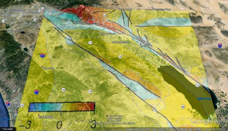
New 3D numerical modeling that captures more geometric complexity of an active fault segment in southern California than any other suggests that the overall earthquake hazard for towns on the west side of the Coachella Valley such as Palm Springs may be slightly lower than previously believed. Credit: Courtesy Google Earth and UMass Amherst
New three-dimensional (3D) numerical modeling that captures far more geometric complexity of an active fault segment in southern California than any other, suggests that the overall earthquake hazard for towns on the west side of the Coachella Valley such as Palm Springs and Palm Desert may be slightly lower than previously believed.
New simulations of deformation on three alternative fault configurations for the Coachella Valley segment of the San Andreas Fault conducted by geoscientists Michele Cooke and Laura Fattaruso of the University of Massachusetts Amherst, with Rebecca Dorsey of the University of Oregon, appear in the December issue of Geosphere.
The Coachella Valley segment is the southernmost section of the San Andreas Fault in California. It has a high likelihood for a large rupture in the near future, since it has a recurrence interval of about 180 years but has not ruptured in over 300 years, the authors point out.
The researchers acknowledge that their new modeling offers “a pretty controversial interpretation” of the data. Many geoscientists do not accept a dipping active fault geometry to the San Andreas Fault in the Coachella Valley, they say. Some argue that the data do not confirm the dipping structure. “Our contribution to this debate is that we add an uplift pattern to the data that support a dipping active fault and it rejects the other models,” say Cooke and colleagues.
Their new model yields an estimated 10 percent increase in shaking overall for the Coachella segment. But for the towns to the west of the fault where most people live, it yields decreased shaking due to the dipping geometry. It yields a doubling of shaking in mostly unpopulated areas east of the fault. “This isn’t a direct outcome of our work but an implication,” they add.
Cooke says, “Others have used a dipping San Andreas in their models but they didn’t include the degree of complexity that we did. By including the secondary faults within the Mecca Hills we more accurately capture the uplift pattern of the region.”
Fattaruso adds, “Others were comparing to different data sets, such as geodesy, and since we were comparing to uplift it is important that we have this complexity.” In this case, geodesy is the science of measuring and representing the Earth and its crustal motion, taking into account the competition of geological processes in 3D over time.
Most other models of deformation, stress, rupture and ground shaking have assumed that the southern San Andreas Fault is vertical, say Cooke and colleagues. However, seismic, imaging, aerial magnetometric surveys and GPS-based strain observations suggest that the fault dips 60 to 70 degrees toward the northeast, a hypothesis they set out to investigate.
Specifically, they explored three alternative geometric models of the fault’s Coachella Valley segment with added complexity such as including smaller faults in the nearby Indio and Mecca Hills. “We use localized uplift patterns in the Mecca Hills to assess the most plausible geometry for the San Andreas Fault in the Coachella Valley and better understand the interplay of fault geometry and deformation,” they write.
Cooke and colleagues say the fault structures in their favored model agree with distributions of local seismicity, and are consistent with geodetic observations of recent strain. “Crustal deformation models that neglect the northeast dip of the San Andreas Fault in the Coachella Valley will not replicate the ground shaking in the region and therefore inaccurately estimate seismic hazard,” they note.
This work was supported by the National Science Foundation.
Reference:
L. A. Fattaruso, M. L. Cooke, R. J. Dorsey. Sensitivity of uplift patterns to dip of the San Andreas fault in the Coachella Valley, California. Geosphere, 2014; 10 (6): 1235 DOI: 10.1130/GES01050.1
This series of images reconstructs the geology of the region around Mars’ Mount Sharp, where NASA’s Curiosity Mars rover landed and is now driving. Credit: NASA/JPL-Caltech
Observations by NASA’s Curiosity Rover indicate Mars’ Mount Sharp was built by sediments deposited in a large lake bed over tens of millions of years
.
This interpretation of Curiosity’s finds in Gale Crater suggests ancient Mars maintained a climate that could have produced long-lasting lakes at many locations on the Red Planet.
“If our hypothesis for Mount Sharp holds up, it challenges the notion that warm and wet conditions were transient, local, or only underground on Mars,” said Ashwin Vasavada, Curiosity deputy project scientist at NASA’s Jet Propulsion Laboratory in Pasadena, California. “A more radical explanation is that Mars’ ancient, thicker atmosphere raised temperatures above freezing globally, but so far we don’t know how the atmosphere did that.”
Why this layered mountain sits in a crater has been a challenging question for researchers. Mount Sharp stands about 3 miles (5 kilometers) tall, its lower flanks exposing hundreds of rock layers. The rock layers — alternating between lake, river and wind deposits — bear witness to the repeated filling and evaporation of a Martian lake much larger and longer-lasting than any previously examined close-up.
“We are making headway in solving the mystery of Mount Sharp,” said Curiosity Project Scientist John Grotzinger of the California Institute of Technology in Pasadena. “Where there’s now a mountain, there may have once been a series of lakes.”
Curiosity currently is investigating the lowest sedimentary layers of Mount Sharp, a section of rock 500 feet (150 meters) high, dubbed the Murray formation. Rivers carried sand and silt to the lake, depositing the sediments at the mouth of the river to form deltas similar to those found at river mouths on Earth. This cycle occurred over and over again.
“The great thing about a lake that occurs repeatedly, over and over, is that each time it comes back it is another experiment to tell you how the environment works,” Grotzinger said. “As Curiosity climbs higher on Mount Sharp, we will have a series of experiments to show patterns in how the atmosphere and the water and the sediments interact. We may see how the chemistry changed in the lakes over time. This is a hypothesis supported by what we have observed so far, providing a framework for testing in the coming year.”
After the crater filled to a height of at least a few hundred yards, or meters, and the sediments hardened into rock, the accumulated layers of sediment were sculpted over time into a mountainous shape by wind erosion that carved away the material between the crater perimeter and what is now the edge of the mountain.
On the 5-mile (8-kilometer) journey from Curiosity’s 2012 landing site to its current work site at the base of Mount Sharp, the rover uncovered clues about the changing shape of the crater floor during the era of lakes.
“We found sedimentary rocks suggestive of small, ancient deltas stacked on top of one another,” said Curiosity science team member Sanjeev Gupta of Imperial College in London. “Curiosity crossed a boundary from an environment dominated by rivers to an environment dominated by lakes.”
Despite earlier evidence from several Mars missions that pointed to wet environments on ancient Mars, modeling of the ancient climate has yet to identify the conditions that could have produced long periods warm enough for stable water on the surface.
NASA’s Mars Science Laboratory Project uses Curiosity to assess ancient, potentially habitable environments and the significant changes the Martian environment has experienced over millions of years. This project is one element of NASA’s ongoing Mars research and preparation for a human mission to the planet in the 2030s.
“Knowledge we’re gaining about Mars’ environmental evolution by deciphering how Mount Sharp formed will also help guide plans for future missions to seek signs of Martian life,” said Michael Meyer, lead scientist for NASA’s Mars Exploration Program at the agency’s headquarters in Washington.
JPL, managed by Caltech, built the rover and manages the project for NASA’s Science Mission Directorate in Washington.
In 2012 the Mars Science Laboratory landed in the fascinating Gale crater. The Gale crater is of such great interest because of the 5.5 km high mountain of layered materials in the middle. This material tells an intricate story of the history of Mars, perhaps spanning much of the existence of this mysterious planet.
Once positioned, the Curiosity rover began field studies on its drive toward Aeolis Mons (also unofficially known as Mount Sharp), the central peak within the crater. Curiosity has travelled more than 9.4 km so far and during its trip up the mountain, Curiosity has begun taking samples of the mountain’s lower slopes.
CheMin is one of ten instruments on or inside Curiosity, all designed to provide detailed information on the rocks, soils and atmosphere.
CheMin is actually a miniaturised X-ray diffraction/X-ray fluorescence (XRD/XRF) instrument, approximately the size of a shoebox, that uses transmission geometry with an energy-discriminating CCD detector to obtain unparalleled results in quite challenging conditions.
Five samples have been analysed by CheMin so far, namely a soil sample, three samples drilled from mudstones and a sample drilled from a sandstone. Rietveld and full-pattern analysis of the XRD data have revealed a complex mineralogy, with contributions from parent igneous rocks, amorphous components and several minerals relating to aqueous alteration, for example clay minerals and hydrated sulphates. In addition to quantitative mineralogy, Rietveld refinements also provide unit-cell parameters for the major phases, which can be used to infer the chemical compositions of individual minerals and, by difference, the composition of the amorphous component. Coincidentally CheMin’s first XRD analysis on Mars coincided with the 100th anniversary of the discovery of XRD by von Laue.
So far CheMin has returned excellent diffraction data comparable in many respects with data available on[powder diffraction pattern from Martian soil] Earth. It has managed this even though several aspects of the instrument, particularly its small size limit the quality of the XRD data. These limitations could, however, be improved through modification of the instrument geometry. One of the most significant issues limiting remote operation is the requirement for powder XRD of a finely powdered sample. CheMin largely surmounts this difficulty through the use of its unique sample vibration device.
Data obtained so far has already provided new insights into processes on Mars, and the instrument promises to return data that will answer numerous questions and shed further light on the history of the Gale crater.
Work is already progressing in developing an upgraded instrument with changes in the reflection geometry. Coupled with data-processing software interface advances, we may see future improvements to non-contact diffraction analysis of the surfaces of planetary bodies.
A video of Professor David L. Bish presenting work from the Mars science mission :