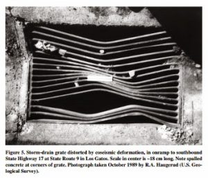
Despite the absence of primary surface rupture from the 1989 Loma Prieta earthquake, patterns of damage to pavement and utility pipes can be used to assess ground deformation near the southwest margin of the densely populated Santa Clara or “Silicon” Valley, California, USA. Schmidt and colleagues utilized more than 1,400 damage sites as an urban strain gage to determine relationships between ground deformation and previously mapped faults.
Post-earthquake surveys of established monuments and the concrete channel lining of Los Gatos Creek reveal belts of deformation consistent with regional geologic structure. The authors conclude that reverse movement largely along preexisting faults, probably enhanced significantly by warping combined with enhanced ground shaking, produced the widespread ground deformation.
Such damage, with a preferential NE-SW sense of shortening, occurred in response to the 1906 and 1989 earthquakes and will likely repeat itself in future earthquakes in the region.
Note : The above story is based on materials provided by The Geological Society of America


