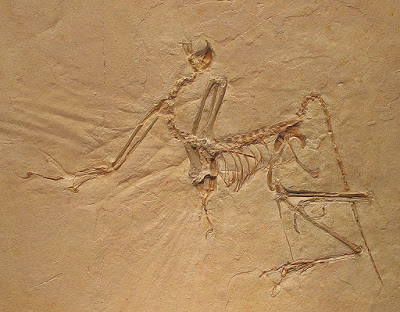
New research led by the American Museum of Natural History reveals that the evolution of modern birds was greatly shaped by the history of our planet’s geography and climate. The DNA-based work, published today in the journal Science Advances, finds that birds arose in what is now South America around 90 million years ago, and radiated extensively around the time of the Cretaceous-Paleogene extinction event that killed off the non-avian dinosaurs.
The new research suggests that birds in South America survived this event and then started moving to other parts of the world via multiple land bridges while diversifying during periods of global cooling.
“Modern birds are the most diverse group of terrestrial vertebrates in terms of species richness and global distribution, but we still don’t fully understand their large-scale evolutionary history,” said Joel Cracraft, a curator in the Museum’s Department of Ornithology and co-author of the paper. “It’s a difficult problem to solve because we have very large gaps in the fossil record. This is the first quantitative analysis estimating where birds might have arisen, based on the best phylogenetic hypothesis that we have today.”
Cracraft and lead author Santiago Claramunt, a research associate in the Museum’s Department of Ornithology, analyzed DNA sequences for most modern bird families with information from 130 fossil birds to generate a new evolutionary time tree.
“With very few exceptions, fossils of modern birds have been found only after the Cretaceous-Paleogene (K-Pg) extinction,” said Claramunt. “This has led some researchers to suggest that modern birds didn’t start to diversify until after this event, when major competitors were gone. But our new work, which agrees with previous DNA-based studies, suggests that birds began to radiate before this massive extinction.”
After the K-Pg extinction, birds used two routes to cover the globe: first, to North America across a Paleogene Central American land bridge and then to the Old World; and second, to Australia and New Zealand across Antarctica, which was relatively warm at that time.
Claramunt and Cracraft also found that bird diversification rates increased during periods of global cooling.
“When the Earth cools and dries, fragmentation of tropical forests results in bird populations being isolated,” Cracraft said. “Many times, these small populations will end up going extinct, but fragmentation also provides the opportunity for speciation to occur and for biotas to expand when environments get warm again. This work provides pervasive evidence that avian evolution has been influenced by plate tectonics and environmental change.”
Reference:
S. Claramunt, J. Cracraft. A new time tree reveals Earth historys imprint on the evolution of modern birds. Science Advances, 2015; 1 (11): e1501005 DOI: 10.1126/sciadv.1501005
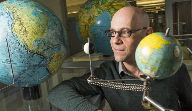
Mathieu Dumberry from the University of Alberta is one of only a few people in the world investigating changes in Earth rotation. Credit: John Ulan for the University of Alberta
Scientists are studying past changes in sea level in order to make accurate future predictions of this consequence of climate change, and they’re looking down to Earth’s core to do so. “In order to fully understand the sea-level change that has occurred in the past century, we need to understand the dynamics of the flow in Earth’s core” says Mathieu Dumberry, a professor in physics at the University of Alberta.
The connection is through the change in the speed of Earth’s rotation. Melt water from glaciers not only causes sea-level rise, but also shifts mass from the pole to the equator, which slows down the rotation. (Picture the Earth as a spinning figure skater. The skater moves his or her arms in to spin more quickly or out to slow down.) The gravity pull from the Moon also contributes to the slow down, acting a little like a leaver break. However, the combination of these effects is not enough to explain the observations of the slowing down of Earth’s rotation: a contribution from Earth’s core must be added.
One of only a few people in the world investigating changes in Earth rotation, Dumberry contributed his expertise on Earth’s core-mantle coupling to the study. “Over the past 3000 years, the core of the Earth has been speeding up a little, and the mantle-crust on which we stand is slowing down.” As a consequence of Earth rotating more slowly, the length of our days is slowly increasing. In fact, a century from now, the length of a day will increase by 1.7 milliseconds. This may not seem like much, but Dumberry notes that this is a cumulative effect that adds up over time.
Based on their work reconciling these discrepancies, the scientists involved in the study are confident in predicting sea level to the end of the 21st century. “This can help to better prepare coastal towns, for example, to cope with climate change,” says Dumberry. “We’re talking billions of dollars of infrastructure here.” Dumberry notes that this study serves as a stimulus for more work to continue investigating the deep interior of our planet.
With 12 climate change-related centres and institutes and 24 climate change-related Canada Research Chairs, the University of Alberta is committed to researching the causes and effects of climate change. Researchers study past climate changes to better predict future changes.
Reference:
J. X. Mitrovica, C. C. Hay, E. Morrow, R. E. Kopp, M. Dumberry, S. Stanley. Reconciling past changes in Earths rotation with 20th century global sea-level rise: Resolving Munks enigma. Science Advances, 2015; 1 (11): e1500679 DOI: 10.1126/sciadv.1500679
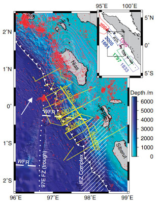
Figure 1 from Henstock et al.,”Downgoing plate topography stopped rupture in the A.D. 2005 Sumatra earthquake. ” This article is open-access online.
New geophysical data show that fault slip during the March 2005 magnitude 8.7 (Mw) earthquake off the west coast of northern Sumatra, Indonesia (also referred to as the Simeulue-Nias earthquake), was stopped by the topography on the downgoing plate.
Earthquakes in subduction zones, where one tectonic plate is forced beneath another, usually break only a part of the plate boundary fault. The pieces that break independently are known as segments. Topography on the top of the downgoing plate has often been suggested a cause of this segmentation, but there are few examples where this topography is as well-known as well as the details of earthquake rupture.
Data collected over the subduction zone offshore of Sumatra, Indonesia, has enabled the top of the downgoing plate to be mapped across a long-lived segment boundary at one end of the rupture zone. Seismic reflection data, similar to that used to find oil reserves, gives a detailed image of the shape of the downgoing plate. A 3-km high on the top of the plate over a 15-km by 30-km region matches where the 2005 earthquake rupture stopped. The topographic high appears to strengthen the plate boundary, and only very large earthquakes would break through this barrier.
This survey by Timothy Henstock and colleagues spans a complex segment boundary zone between the southern termination of the Mw 8.7 earthquake and the northern termination of a major 1797 earthquake that was partly filled by a Mw 7.7 event in 1935. They have identified an isolated 3 km basement high at the northern edge of this zone, close to the 2005 slip termination. They note that the high probably originated at the Wharton fossil ridge, and is almost aseismic in both local and global data sets, suggesting that while the region around it may be weakened by fracturing and fluids, the basement high locally strengthens the plate boundary, stopping rupture propagation.
Reference:
Timothy J. Henstock et al. Downgoing plate topography stopped rupture in the A.D. 2005 Sumatra earthquake, Geology (2015). DOI: 10.1130/G37258.1
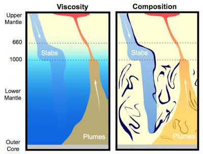
Sinking slabs of ocean crust and rising plumes of hot rock in Earth’s mantle are observed to behave differently below one megameter (1,000 kilometers) depth. Two explanations for this behavior were published on Dec. 11, 2015. At left, Rudolph et al. (Science, 2015) propose a viscosity increase (dark blue) below the megameter boundary. At right, Ballmer et al. (Science Advances, 2015) propose a density increase due to accumulated ocean crust (dark squiggles) below the boundary. Credit: Nicholas Schmerr/Vedran Lekic/UMD
Earth’s mantle, the large zone of slow-flowing rock that lies between the crust and the planet’s core, powers every earthquake and volcanic eruption on the planet’s surface. Evidence suggests that the mantle behaves differently below 1 megameter (1,000 kilometers, or 621 miles) in depth, but so far seismologists have not been able to explain why this boundary exists.
Two new studies co-authored by University of Maryland geologists provide different, though not necessarily incompatible, explanations. One study suggests that the mantle below 1 megameter is more viscous–meaning it flows more slowly–than the section above the boundary. The other study proposes that the section below the boundary is denser–meaning its molecules are more tightly packed–than the section above it, due to a shift in rock composition.
Taken together, the studies provide the first detailed look at why large-scale geologic features within the mantle behave differently on either side of the megameter divide. The papers were published on December 11, 2015, in the journals Science and Science Advances.
“The existence of the megameter boundary has been suspected and inferred for a while,” said Vedran Lekic, an assistant professor of geology at UMD and co-author of the Science paper that addresses mantle viscosity. “These papers are the first published attempts at a detailed explanation and it’s possible that both explanations are correct.”
Although the mantle is mostly solid, it flows very slowly in the context of geologic time. Two main sources of evidence suggest the existence of the megameter boundary and thus inspired the current studies.
First, many huge slabs of ocean crust that have been dragged down, or subducted, into the mantle can still be seen in the deep Earth. These slabs slowly sink downward toward the bottom of the mantle. A large number of these slabs have stalled out and appear to float just above the megameter boundary, indicating a notable change in physical properties below the boundary.
Second, large plumes of hot rock rise from the deepest reaches of the mantle, and the outlines of these structures can be seen in the deep Earth as well. As the rock in these mantle plumes flows upward, many of the plumes are deflected sideways as they pass the megameter boundary. This, too, indicates a fundamental difference in physical properties on either side of the boundary.
“Learning about the anatomy of the mantle tells us more about how the deep interior of Earth works and what mechanisms are behind mantle convection,” said Nicholas Schmerr, an assistant professor of geology at UMD and co-author of the Science Advances paper that addresses mantle density and composition. “Mantle convection is the heat engine that drives plate tectonics at the surface and ultimately leads to things like volcanoes and earthquakes that affect people living on the surface.”
The physics of the deep Earth are complicated, so establishing the mantle’s basic physical properties, such as density and viscosity, is an important step. Density refers to the packing of molecules within any substance (gas, liquid or solid), while viscosity is commonly described as the thickness of a fluid or semi-solid. Sometimes density and viscosity correlate with each other, while sometimes they are at odds. For example, honey is both more viscous and dense than water. Oil, on the other hand, is more viscous than water but less dense.
In their study, Schmerr, lead author Maxim Ballmer (Tokyo Institute of Technology and the University of Hawaii at Manoa) and two colleagues used a computer model of a simplified Earth. Each run of the model began with a slightly different chemical composition–and thus a different range of densities–in the mantle at various depths. The researchers then used the model to investigate how slabs of ocean crust would behave as they travel down toward the lower mantle.
In the real world, slabs are observed to behave in one of three ways: The slabs either stall at around 600 kilometers, stall out at the megameter boundary, or continue sinking all the way to the lower mantle. Of the many scenarios for mantle chemical composition the researchers tested, one most closely resembled the real world and included the possibility that slabs can stall at the megameter boundary. This scenario included an increased amount of dense, silicon-rich basalt rock in the lower mantle, below the megameter boundary.
Lekic, lead author Max Rudolph (Portland State University) and another colleague took a different approach, starting instead with whole-Earth satellite measurements. The team then subtracted surface features–such as mountain ranges and valleys–to better see slight differences in Earth’s basic shape caused by local differences in gravity. (Imagine a slightly misshapen basketball with its outer cover removed.)
The team mapped these slight differences in Earth’s idealized shape onto known shapes and locations of mantle plumes and integrated the data into a model that helped them relate the idealized shape to differences in viscosity between the layers of the mantle. Their results pointed to less viscous, more free-flowing mantle rock above the megameter boundary, transitioning to highly viscous rock below the boundary. Their results help to explain why mantle plumes are frequently deflected sideways as they extend upward beyond the megameter boundary.
“While explaining one mystery–the behavior of rising plumes and sinking slabs–our results lead to a new conundrum,” Lekic said. “What causes the rocks below the megameter boundary to become more resistant to flow? There are no obvious candidates for what is causing this change, so there is a potential for learning something fundamentally new about the materials that make up Earth.”
Lekic and Schmerr plan to collaborate to see if the results of both studies are consistent with one another–in effect, whether the lower mantle is both dense and viscous, like honey, when compared with the mantle above the megameter boundary.
“This work can tell us a lot about where Earth has been and where it is going, in terms of heat and tectonics,” Schmerr said. “When we look around our solar system, we see lots of planets at various stages of evolution. But Earth is unique, so learning what is going on deep inside its mantle is very important.”
References:
Maxwell Rudolph, Vedran Lekic and Carolina Lithgow-Bertelloni. Viscosity jump in Earth’s mid-mantle. Science, December 11, 2015 DOI: 10.1126/science.aad1929
Maxim Ballmer, Nicholas Schmerr, Takashi Nakagawa and Jeroen Ritsema. Compositional mantle layering revealed by slab stagnation at ~1000-km depth. Science Advances, December 11, 2015. DOI: 10.1126/sciadv.1500815
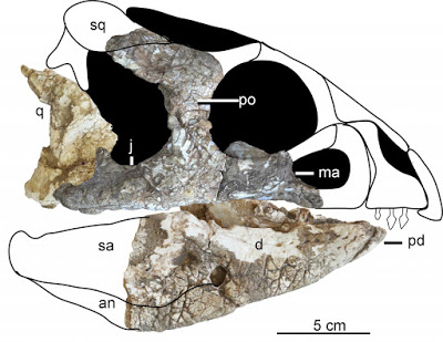
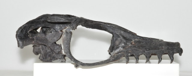
This is the reconstructed skull of the holotype specimen of Hualianceratops wucaiwanensis (IVPP V18641). Abbreviations: an, angular; d, dentary; j, jugal; ma, maxilla; pd, predentary; po, postorbital; q, quadrate; sa, surangular; sq, squamosal Credit: Han et al.
Scientists describe a new, ~160 million year-old ceratopsian dinosaur with “ornamental” texture on the skull from the Late Jurassic period in China, according to a study published December 9, 2015 in the open-access journal PLOS ONE by Fenglu Han from the China University of Geosciences and colleagues.
Ceratopsia is one of the best studied herbivorous dinosaur clades, but scientists still don’t agree on the early evolution of Ceratopsia. The authors of this study report on the second ceratopsian found in an Upper Jurassic formation in northwestern China, from ~160 million years ago, both of which are the oldest ceratopsians known. The authors characterize this new taxon by the ornamental texture on nearly all parts of the skull, among other characteristics, and named it Hualianceratops wucaiwanensis. “Hualian” means ornamental face. Unfortunately, the skull was found with a partial skeleton in poor condition, and little information about the body could be collected.
Additionally, the authors studied the relationship between Hualianceratops wucaiwanensis and other ceratopsians through phylogenetic analysis. Based on the results, they suggest that at least five ceratopsian lineages, may have been present at the beginning of the Late Jurassic.
Reference:
Han F, Forster CA, Clark JM, Xu X (2015) A New Taxon of Basal Ceratopsian from China and the Early Evolution of Ceratopsia. PLoS ONE 10(12): e0143369. DOI:10.1371/journal.pone.0143369
Note: The above post is reprinted from materials provided by PLOS.
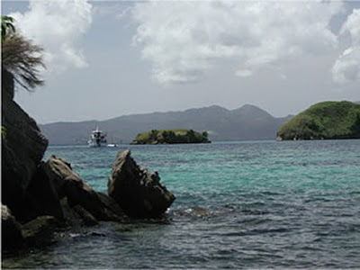
Milne Bay Province in Papua New Guinea, where mineral samples were taken for Baldwin and Das’ study. Credit: Paul Fitzgerald
With every breath we take, we inhale not only oxygen, but also a mix of gases. This mixture includes carbon dioxide and nitrogen, but also a gas called argon. Neon, the gas that illuminates the signs of all-night diners, is also in the mix.
Our lungs recycle atmospheric argon and neon, in and out with every breath, but lungs are not alone in the recycling game. The Earth, itself, recycles atmospheric gases into the deep Earth and back to the surface again, but on a much longer time scale.
A new study by Suzanne Baldwin, the Michael G. and Susan T. Thonis Professor of Earth Sciences, and Jayeshkumar Das, a research associate of Earth sciences, brings insight to how atmospheric noble gases, in particular argon and neon, cycle from the surface to the Earth’s mantle, and back to the surface again. Their study, ‘Atmospheric Ar and Ne returned from mantle depths to the Earth’s surface via forearc recycling,’ is in the early edition of Proceedings of the National Academy of Sciences.
Argon and neon are noble gases that have been around since our solar system formed 4.6 billion years ago, from a vast cloud of gas and dust. The Earth formed from an accumulation of gas, dust, and small planetary objects. Because noble gases are chemically inert at conditions relevant to processes on Earth, they don’t react with other elements.
“The fact that the noble gases don’t react with other elements makes them excellent tracers for understanding the geochemical evolution of Earth and its atmosphere,” Baldwin says.
Slightly different forms, or isotopes, of neon and argon exist in the Earth and atmosphere. “Measuring the isotopic composition and concentrations of argon and neon trapped in new minerals that have formed at mantle depths can help us to understand where these noble gases originated,” Baldwin says. “When the minerals crystallized in the mantle, they trapped atoms of argon and neon within them.”
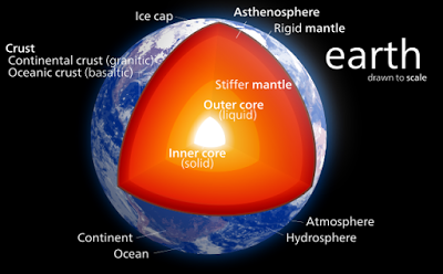
The Earth, itself, has many layers. The outermost layer is the crust, which, along with the uppermost mantle beneath it, comprises the lithospheric plates. These plates move slowly, relative to one another, and, at convergent plate boundaries, one plate can be pushed underneath (i.e., subducted) the other. Over long periods of time (think millions of years), the crust is subducted deep into the mantle. While in the mantle, the minerals change their compositions and structure, and later can be exhumed to the surface with those new minerals formed during their time in the Earth’s mantle.
Baldwin’s team discovered an area in Papua New Guinea that had been through just such a subduction and exhumation cycle. They determined that the rocks of eastern Papua New Guinea were derived from the Australian lithospheric plate. They documented that some of the minerals, now found at the surface, formed at ultra-high pressure, approximately 8 million years ago, at depths greater than 90 kilometers, or roughly the distance from New York City to Philadelphia.
As it turns out, Baldwin and her team discovered the youngest examples of exhumed ultra-high pressure rocks of their kind.
By analyzing the composition and concentrations of argon and neon isotopes trapped within the minerals collected from modern-day Papua New Guinea, Baldwin and Das identified the source of the mineral-bound gases. “We documented that atmospheric argon and neon were available at mantle depths when minerals crystallized deep in the Earth,” Baldwin says.
She explains that the presence of atmospheric argon and neon trapped in these minerals indicates that the atmospheric gases were subducted into the mantle and available to be entrapped in minerals crystallizing at ultra-high pressures. What’s more, when the minerals return to the surface in the forearcs of subduction zones, they can break down over millions of years, releasing gases back to atmosphere once again.
“We were expecting mantle argon and neon to be trapped in the minerals formed at ultra-high pressure conditions,” Das says.
Adds Baldwin: “But we found that atmospheric argon and neon was, in fact, trapped in these minerals.”
Reference:
Suzanne L. Baldwin et al. Atmospheric Ar and Ne returned from mantle depths to the Earth’s surface by forearc recycling, Proceedings of the National Academy of Sciences (2015). DOI: 10.1073/pnas.1424122112
A new study finds that the viscosity of the Earth’s mantle abruptly increases 1,000 kilometers (621 miles) below the surface, differing significantly from previous estimates, which suggest this phenomenon occurs at depths of roughly 670 km (416 miles).
Accurately pinpointing viscosity changes within Earth’s mantle is important for understanding numerous processes within the planet’s deep interior, including heat transport, compositional mixing, and slab (tectonic plate) descent, as well as understanding the mantle’s thermal and chemical evolution.
The geoid (the shape that ocean surfaces would take under the influence of Earth’s gravitation and rotation alone) is most sensitive to density structure and viscosity contrasts in the lower mantle, and thus offers a good way to determine mantle viscosity. Here, Maxwell Rudolph et al. combined several geophysical data sets that account for the geoid, including ten years’ worth of satellite observations and updated estimates of Earth’s flattening.
After running numerous simulations, all of their results found the viscosity increase to lie below 670 km, and most simulations place this viscosity increase deeper still, in the vicinity of 1,000 km. The authors note that their new estimate of viscosity transition aligns with depths where tectonic plates stagnate, according to some recent studies.
As well, the authors note that their new viscosity estimate may help to explain the vertical and lateral movement of plumes that rise towards Earth’s surface, creating areas of greater volcanic activity, such as the Iceland hotspot and the Macdonald hotspot in the South Pacific. Although the viscosity increase solves some geological observations, the origin of this increase remains a mystery.
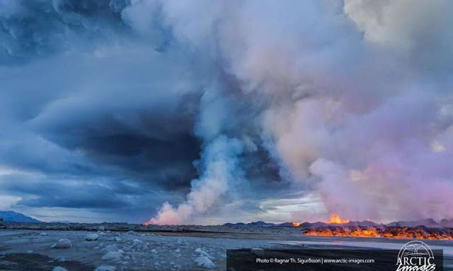
The Bardarbunga event was a fissure that emitted sulfur emissions during six months, providing a model for how volcanic or human emissions alter clouds. Credit: Ragnar Th Sigurdsson/Arctic-Images.com
It has long been suspected that sulfur emissions can brighten clouds. Water droplets tend to clump around particles of sulfuric acid, causing smaller droplets that form brighter, more reflective clouds.
But while humans have pumped sulfur into Earth’s atmosphere since the Industrial Revolution, it’s been hard to measure how this affects the clouds above. New University of Washington research uses a huge volcanic eruption in Iceland to measure the change.
The new study, to be published in Geophysical Research Letters, a journal of the American Geophysical Union, shows that sulfur emissions do indeed result in smaller cloud droplet size, leading to brighter clouds that reflect significantly more sunlight.
“This eruption is a chance to nail down one of the big uncertainties in climate models,” said first author Daniel McCoy, a UW doctoral student in atmospheric sciences.
The study takes advantage of a unique geologic event. During six months from summer 2014 until early 2015, a crack in the Bardarbunga volcano seeped lava and sulfur gas. This was not one of Iceland’s huge explosive eruptions that fill the skies with ash and shut down airplane routes. Instead it was a long, slow, low-elevation seep of sulfur emissions that produced an amount of lava second only to Laki in the recent history of Iceland eruptions.
The UW researchers looked at data for that region recorded by NASA’s MODIS, or Moderate Resolution Imaging Spectroradiometer, instrument to measure the size of droplets in the marine cloud layer. While the volcano was spewing sulfur, the droplets were the smallest in the 14-year record of observations.
“You can see the effect over an entire ocean for a two-month period,” McCoy said. “It was a pretty unique geophysical event within the satellite record.”
The results confirm that volcanoes cool the planet not just by emitting particles high in the atmosphere, but also by releasing low-level sulfur to influence cloud formation.
When the air contains aerosol particles, the same amount of water vapor condenses into many small drops, whose larger surface area reflects more sunlight. The difference in reflected solar radiation for September and October 2014 was 2 watts per square meter in the region over Iceland.
“The effect of volcanic emissions on clouds has been a difficult one to quantify because of the ephemeral nature of most events,” said co-author Dennis Hartmann, a UW professor of atmospheric sciences. “This eruption provides a natural laboratory that lets us test how clouds respond to aerosols.”
The results may help understand humans’ impact on clouds. Human pollution since the Industrial Revolution is believed to have altered skies in the Northern Hemisphere. One uncertainty in climate models is how much human pollution has brightened the clouds, shielding the planet from the effects of the simultaneous rise in carbon dioxide.
“One of the big uncertainties regarding climate change is how much human-produced aerosols have offset the warming until now,” Hartmann said. “We hope the data from this eruption will improve the model simulations of cloud effects, and narrow the uncertainties in projections of the future.”
The most recent Intergovernmental Panel on Climate Change report was the first to include a chapter on clouds and aerosols, one of the biggest uncertainties in global climate models. This study will provide a benchmark for modelers to check their simulations of clouds and aerosols and improve their algorithms for the next generation of climate models.
“The same way that the Mount Pinatubo eruption in 1991 was a big on-off signal that allowed us to evaluate models’ response to volcanic forcings, I think this Iceland eruption is a unique event that will help us to better understand the interaction between aerosols and clouds,” McCoy said.
Reference:
Daniel T. McCoy and Dennis L. Hartmann. Observations of a substantial cloud aerosol indirect effect during the 2014–2015 Bárðarbunga-Veiðivötn fissure eruption in Iceland. DOI: 10.1002/2015GL067070
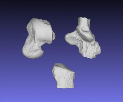
This image shows the ankle bones of Galecyon in dorsal (top) view. Elements are (clockwise from top left) astragalus, calcaneus, and cuboid. Credit: Image by S. Zack
Prior to the rise of modern day mammalian carnivores (lions and tigers and bears, as well as weasels, raccoons, wolves and other members of the order Carnivora), North America was dominated by a now extinct group of mammalian carnivores — the hyaenodontids. While fossils of hyaenodontids are relatively common from the early Eocene (between 50 and 55 million years ago), most of these are specimens of teeth. A new find of a nearly complete skeleton, described in the most recent issue of the Journal of Vertebrate Paleontology, has allowed for a more detailed study of the ecology and evolutionary relationships of these early carnivores.
The recent find, a skeleton of the hyaenodontid Galecyon, was found in an area of Wyoming well-known for fossils of this age. Lead author Shawn Zack of the University of Arizona says, “The skeleton of Galecyon shows why we keep looking for fossils even in places where we already have a lot of specimens. When this skeleton was found, tens of thousands of mammalian fossils had been collected from the Bighorn Basin, but this was the first decent skeleton of this animal.”
Galecyon was about the size of a modern coyote, and the new find allowed the researchers, Zack and co-author Ken Rose of Johns Hopkins University, to infer the locomotory abilities of this fossil taxon. “Galecyon may have moved around like a living wolverine or skunk,” says Zack, “probably not much of a runner, but spending most of its time on the ground, while some of its relatives spent a lot more time in the trees.”
In addition to telling us something about the way this fossil animal lived, the fossil also allowed the researchers to investigate the ecological and evolutionary relationships among hyaenodontids. Since teeth are the most commonly found elements of the skeleton, this is normally done using dental characters, but the new specimen allows for the addition of characters in other parts of the skeleton.
“This study is a ‘tour de force’ in terms of the completeness of the description, imaging and analysis — a great example of how to combine systematics with functional morphology and phylogenetic reconstruction to produce a solid result and testable hypotheses for future work” says Gregg Gunnell, a paleontologist from Duke University not involved with the study.
“This study shows that postcranial and dental morphology support different patterns of hyaenodontid relationships. That is an indication that there is still a lot to learn about hyaenodontid evolution,” says Zack. In addition, “This study shows that early hyaenodontids had diverse habitat preferences, which helps explain how several different hyaenodontids were able to coexist in the same faunas, despite having similar diets and comparable body sizes.”
Reference:
Shawn P. Zack, Kenneth D. Rose. The postcranial skeleton ofGalecyon: evidence for morphological and locomotor diversity in early Hyaenodontidae (Mammalia, Hyaenodontida). Journal of Vertebrate Paleontology, 2015; 35 (6): e1001492 DOI: 10.1080/02724634.2014.1001492
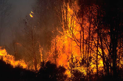
New fossil evidence shows that Australia’s fire-prone shrubland open vegetation originated at least 70 million years ago — 40-50 million years earlier than previously thought.
The findings, published online ahead of print in the American Journal of Botany, reject prevailing wisdom that Australia was covered with rainforest until 40 million years ago, and that currently dominant native vegetation types evolved after that on a drying continent with increasing fire.
“I grew up and started working believing that this iconic Australian vegetation evolved under the influence of fires as the rainforests dried out, largely over the last 25 million years or so. But it now looks like our fire-prone vegetation has much more ancient origins,” says co-author Professor Bob Hill, Executive Dean of the University of Adelaide’s Faculty of Sciences.
“This dryland, fire-prone vegetation actually precedes the mega-rainforests and it somehow managed to survive through the wetter times.”
The breakthrough comes out of a long-term research partnership of about 30 years between Professor Hill and colleagues Dr Ray Carpenter (Research Fellow at University of Tasmania and University of Adelaide), Associate Professor Greg Jordan (University of Tasmania) and Dr Mike Macphail (Australian National University).
The researchers studied sediment, dated from the Late Cretaceous period by Dr Macphail, from core drilled in the Bundey Basin of central Australia, northeast of Alice Springs, by the Northern Territory Geological Survey. Dr Carpenter detected numerous tiny leaf fragments from the family Proteaceae, which now includes well-known native plants such as Banksia, Macadamia and Grevillea. It was also evident that fire had been part of the landscape from the preserved charcoal material.
“Amazingly, we think part of the ancient vegetation was similar to what you can now see in south-western Australia, and there were even a couple of leaf bits that look just like Banksia,” says Dr Carpenter.
“Banksia is one of Australia’s most iconic native plants and is very often associated with fire. Somehow this family of plants has shown extraordinary persistence over an incredibly long period of time, through extremely variable climatic conditions.”
Associate Professor Jordan says the widespread burning of the Late Cretaceous is likely to have reduced the amount of phosphorus in the soils.
“Wildfires would have promoted the spread of plants like Proteaceae, able to thrive on these marginal soils and giving them a competitive advantage,” Associate Professor Jordan says.
“We’re a long way from properly understanding how to manage fire in our landscape now,” says Professor Hill. “To do that we need to understand how fire and vegetation co-evolved. This research is a significant step towards that understanding.”
Reference:
R. J. Carpenter, M. K. Macphail, G. J. Jordan, R. S. Hill. Fossil evidence for open, Proteaceae-dominated heathlands and fire in the Late Cretaceous of Australia. American Journal of Botany, 2015; DOI: 10.3732/ajb.1500343
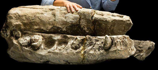
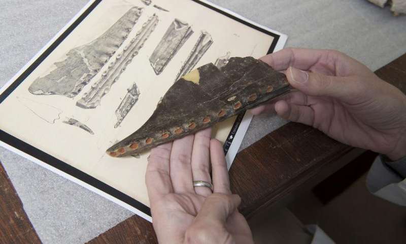
Research student Alex Boersma with the type fossil specimen of Albicetus oxymycterus, composed of the beak and lower jaws of the whale. The specimen is about 14-16 million years old. Credit: Jame Di Loreto, Smithsonian.
In Herman Melville’s Moby-Dick, the book’s narrator, a sailor named Ishmael, presents a painstaking mid-19th-century classification of the whales that he encountered during his maritime career sailing the open seas. More than 160 years later, little of Ishmael’s proposed classification remains intact, having given way to countless revisions in scientific understanding of the evolution and diversity of living whales.
Now, scientists with the Smithsonian’s National Museum of Natural History are re-examining the classification of an extinct 15 million-year-old fossil sperm whale. The fossil whale was originally described and named in 1925 by Smithsonian scientist Remington Kellogg as Ontocetus oxymycterus, but Kellogg miscategorized it as belonging to a group of extinct walruses. In re-examining this fossil sperm whale for the first time in 90 years, the team created an entirely new group in the sperm whale family, Albicetus, and introduced the species, Albicetus oxymycterus, to a new branch on the sperm whale family tree. The scientists contend that the toothy fossil provides evidence of ancient seas rich in the number and diversity of marine mammals. Their findings are published in the Dec. 9 issue of the scientific journal PLOS ONE.
The fossils of this sperm whale, which represent the animal’s skull, jaws and teeth, date 14–16 million years ago, in a time known as the Middle Miocene, and were found in California in the 1880s. Because of the fossils’ bone-white color, the research team decided to name the new genus Albicetus, translating to “white whale,” in honor of Melville’s famous leviathan.
“While we don’t know what its skin color in life actually looked like, the color of the fossil is an ashen white,” said Nick Pyenson, curator of marine mammals in the museum’s Department of Paleobiology. “It only seemed appropriate to evoke Melville’s white sperm whale, Moby Dick, especially since we studied A. oxymycterus alongside the skeletons of some of its modern-day relatives in the collections here at the Smithsonian.”
In addition to studying the fossil itself, the team compared the jaw bones and other pieces to the corresponding anatomy from 36 other sperm whale specimens, both existing and extinct species held in the museum’s collections.
“The sheer size of this fossil, especially the block that preserves the skull and jaws, is impressive,” Pyenson said. “It probably weighs several hundred pounds and required a lot of muscle just to move around. It’s only with recent advancements in 3-D digitization that we were able to capture the entire geometry of this specimen and better understand the unusual anatomy of this extinct species of sperm whale.”
“One of our most important findings in studying Albicetus was that it not only represented an entirely new genus of fossil sperm whale, but it also prompted us to look where exactly Albicetus fit into the evolution of sperm whales,” said Alexandra Boersma, the team’s lead author and a research student at the museum during the time of research. “Modern sperm whales are unique in the whale world, with their ability to dive nearly two kilometers and their complex social groups, and they have the largest brains of any creature alive today. Understanding the evolutionary context in which living sperm whales evolved has a lot of implications for disciplines outside of paleobiology.”
Sperm whales are among the oldest lineages of Cetacea (the scientific term for all whales, dolphins and porpoises), with the oldest known specimen dating to about 25 million years ago. A phylogenetic analysis of A. oxymycterus, along with other fossil and living sperm whale species, revealed it to be what is known as a “stem” species in the sperm whale lineage―one that diverged from the main line of evolution to begin a new branch.
Boersma and Pyenson also estimate that A. oxymycterus grew to approximately 20 feet in length, making it moderately sized within the sperm whale family. Unlike many terrestrial animals whose ancestors were larger than their modern counterparts, the modern sperm whale is by far the largest in its family’s history with many mature males exceeding a length of 60 feet. However, whales of comparably large body size to Albicetus have arisen multiple times in the evolution of sperm whales, and the majority of these large whales also have unusually large upper and lower teeth. The only exceptions are the modern sperm whale and its closest fossil relative, which only have teeth in their lower jaw.
The team contends that the presence of big teeth in fossil sperm whales may suggest they were feeding on large prey, perhaps marine mammals such as seals and other smaller whales. Modern sperm whales, on the other hand, currently feed primarily on squid and mostly lack large upper teeth. In fact, many reports of living sperm whales collected on whaling expeditions document pathologically deformed lower jaws in adult specimens, complete with a set of lower teeth, suggesting that sperm whales use their jaws for reasons that may not be related to feeding.
“If you were able to go snorkelling in the Miocene oceans around 15 million years ago, you would have been able to see lots of different species of large sperm whales with big teeth like Albicetus,” Boersma said. “This time in the evolutionary history of whales seems to have been a moment of peak richness in the number and diversity of marine mammals, which may have served as a prey source for all of these whales.”
Reference:
Alexandra T. Boersma, Nicholas D. Pyenson. Albicetus oxymycterus, a New Generic Name and Redescription of a Basal Physeteroid (Mammalia, Cetacea) from the Miocene of California, and the Evolution of Body Size in Sperm Whales. DOI: 10.1371/journal.pone.0135551
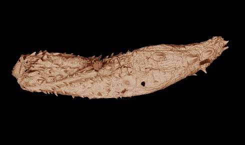
Details of the Eokinorhynchus rarus fossil, only a few millimeters in length, can be seen in this electron microscopic image. More than 530 million years old, the ancient worm was found in South China and is closely related to the ancestor of modern animal phylum kinorhyncha.
A team of Virginia Tech researchers have discovered fossils of kinorhynch worms – commonly known as mud dragons – dating back more than 530 million years.
The historic find – made in South China—fills a huge gap in the known fossil record of kinorhynchs, small invertebrate animals that are related to arthropods, featuring exoskeletons and segmented bodies, but not jointed legs. The first specimen was unearthed in rocks in Nanjiang, China, in 2013 and more fossils were found later that year and in 2014.
Helping lead the international team of scientists and biomedical engineers who unearthed, studied, and imaged the ancient, armored, worm-like creature is Shuhai Xiao, a professor of geobiology in the Department of Geosciences, part of the College of Science at Virginia Tech. Dubbed Eokinorhynchus rarus – or rare ancient mud dragon, the newly discovered animal dates back from the Cambrian period and contains five pairs of large bilaterally placed spines on its trunk. It is believed to be related to modern kinorhynchs.
The group’s findings were published in Scientific Reports, a Nature family journal.
“Kinos represent an animal group that is related to arthropods—insects, shrimps, spiders, etc.—which are the most diverse group of animals on the planet,” said Xiao, who refers to kinorhynchs as “kinos” for short. “Although arthropod fossils date back to more than 530 million years ago, no kino fossils have ever been reported. This is a huge gap in the fossil record, with more than 540 million years of evolutionary history undocumented. Our discovery is the first report of kino fossils.”
Xiao added that the new fossil can tell scientists more about how and why body segmentation evolved many times among not only arthropods, but several other groups of animals. Scientists believe kinos and arthropods should have evolved more than 540 million years ago. More so, the authors found that E. rarus has a number of similarities with living kinorhynchs, suggesting a close evolutionary relationship.
Similarities between the fossils of E. rarus and living, modern kinorhynchs include their hollow spines arranged in a five-fold symmetry and their body segments each consisting of articulated plates. However, E. rarus differs from modern species with more numerous segments. Hence the belief of an ancestorship.
There are approximately 240 living kinorhynch species, all found in marine environments. The body of kinorhynchs is divided into three sections: a head, which includes a mouth cone with teeth; a neck; and a trunk with 11 segments. These creatures could provide clues to origins of body segmentation, but such efforts have been hampered by a lack of well-preserved kinorhynch fossils, until now, said Xiao.
The found specimen is 0.078 inches in length and l0.02 inches in width, roughly half the size of a grain of rice, said Xiao.
The discovery and resulting research is a collaborative effort with Xiao’s geosciences department, the Virginia Tech College of Engineering, the Chinese Academy of Sciences, and Chang’an University in Xi’an of China. On the team are Drew Muscente of Allentown, New Jersey, and a doctoral student in geosciences; Guohua Cao, an assistant professor, and Hao Gong of Fuzhou, China, a doctoral student, both in the Virginia Tech Department of Biomedical Engineering and Mechanics; Huaqiao Zhang, Xunlai Yuan, and Bin Wan, of the Chinese Academy of Sciences; and Yunhuan Liu and Tiequan Shao, both professors at Chang’an University who were visiting faculty at Virginia Tech while most of the study was carried out.
The first kino fossil was unearthed by Zhang. “He sent me an image of the fossil for identification. I immediately recognized it as something very similar to modern kinos,” said Xiao. Xiao studied the specimen using an X-ray micro-CT located at the Virginia Tech Corporate Research Center. Meanwhile, Liu discovered additional specimens in her collection of fossils.
“We used electron microscopy to thoroughly image the fossils’ surface features, and then the microCT to scan their interior structures, including their midguts,” said Muscente, who devised an X-ray transparent plastic grid to secure the specimen during examination. He also collected with Gong microCT data that were used in generating the microCT reconstruction. “Because this suite of data is so comprehensive, it includes pretty much everything you can know about the morphologies of the fossils.”
Xiao and his team believe more specimens will be found. “Future discovery of additional kino fossil will offer important insights into the early evolutionary history of this group of tiny and little-known animals.”
Reference:
Huaqiao Zhang et al. Armored kinorhynch-like scalidophoran animals from the early Cambrian, Scientific Reports (2015). DOI: 10.1038/srep16521
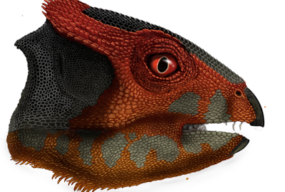
Researchers have described a new species of plant-eating dinosaur, Hualianceratops wucaiwanensis, that stood on its hind feet and was about the size of a spaniel. Credit: Portia Sloan Rollings
The Ceratopsia family is growing again. Researchers have described a new species of plant-eating dinosaur, Hualianceratops wucaiwanensis, that stood on its hind feet and was about the size of a spaniel. It is similar in age to the oldest-known member of the “horned dinosaurs,” Yinlong downsi, although both are hornless.
The findings will be published in PLOS ONE on Dec. 9.
Hualianceratops was robust and heavily built, like a chunky version of Yinlong, which was discovered by the same group in 2002. Led by James Clark, Ronald Weintraub Associate Professor of Biology at the George Washington University and Xu Xing, professor at the Chinese Academy of Sciences, the group discovered the two species in the same fossil beds in Xinjiang Province, China. Working from a partial skull and foot, scientists have reconstructed the new dinosaur and compared it to other ceratopsians.
“Finding these two species in the same fossil beds reveals there was more diversity there than we previously recognized,” said co-author Catherine Forster, professor of biology in the Geological Sciences Program at GW. “It suggests that the ceratopsian dinosaurs already had diversified into at least four lineages by the beginning of the Jurassic Period.”
Identifying the new species helps researchers reexamine the pace and pattern of ceratopsian evolution. Hualianceratops lived approximately 160 million years ago (early in the Late Jurassic Period), and the evolutionary relationships the researchers discovered for the new species and other ceratopsians indicate that several lineages of ceratopsians were present at the same time, including the diverse group Neoceratopsia that dominated the Late Cretaceous.
“Identifying Hualianceratops allows us to expand the beaked family of dinosaurs (Ceratopsia), which includes popular species like Triceratops and Psittacosaurus,” said Fenglu Han, a postdoctoral student in the School of Earth Sciences at China University of Geosciences and lead author of the paper. “Now we know the horned dinosaurs thrived in the early Late Jurassic, and they co-existed with Guanlong, which was an early relative of T. rex and maybe threatened them.”
Video
Reference:
Han F, Forster CA, Clark JM, Xu X (2015) A New Taxon of Basal Ceratopsian from China and the Early Evolution of Ceratopsia. PLoS ONE 10(12): e0143369. DOI: 10.1371/journal.pone.0143369
International research partnership discovers rare mosasaur fossil, the first ancient marine reptile of its kind to be found in Japan. Credit: Takuya Konishi
An international research partnership is revealing the first mosasaur fossil of its kind to be discovered in Japan. Not only does the 72-million-year-old marine reptile fossil fill a biogeographical gap between the Middle East and the eastern Pacific, but also it holds new revelations because of its superior preservation. This unique swimming lizard, now believed to have hunted on glowing fish and squids at night, is detailed in an article led by Takuya Konishi, a University of Cincinnati assistant professor of biological sciences. The article is published in the Journal of Systematic Palaeontology, a publication of the Natural History Museum in London.
The fossil marine reptile, Phosphorosaurus ponpetelegans (a phosphorus lizard from an elegant creek), existed during the Late Cretaceous Period just before the last of the dinosaurs such as Tyrannosaurus and Triceratops. Compared with some of their mosasaur cousins that could grow as large as 40 feet, this species is relatively small, about 3 meters, or 10 feet long. This unique discovery in a creek in the town of Mukawa in northern Japan reveals that they were able to colonize throughout the northern hemisphere.
“Previous discoveries of this particular rare mosasaur have occurred along the East Coast of North America, the Pacific Coast of North America, Europe and North Africa, but this is the first to fill the gap between the Middle East and the Eastern Pacific,” explains Konishi, a member of the research team that also was represented by the Royal Tyrrell Museum of Palaeontology (Canada), University of Alberta, Brandon University, Hobetsu Museum (Japan), Fukuoka University and the town of Mukawa.
Because the fossil was so well preserved, the creature revealed it had binocular vision — its eyes were on the front of the face, providing depth perception. This was a new discovery for this fossil species. The discovery reveals that the eye structure of these smaller mosasaurs was different from their larger cousins, whose eyes were on either side of their large heads, such as the eye structure of a horse. The eyes and heads of the larger mosasaurs were shaped to enhance streamlined swimming after prey that included fish, turtles and even small mosasaurs.
“The forward-facing eyes on Phosphorosaurus provide depth perception to vision, and it’s common in birds of prey and other predatory mammals that dwell among us today,” says Konishi. “But we knew already that most mosasaurs were pursuit predators based on what we know they preyed upon — swimming animals. Paradoxically, these small mosasaurs like Phosphorosaurus were not as adept swimmers as their larger contemporaries because their flippers and tailfins weren’t as well developed.”
As a result, Konishi says it’s believed these smaller marine reptiles hunted at night, much like the owl does compared with the daytime birds of prey such as eagles. The binocular vision in nocturnal animals doubles the number of photoreceptors to detect light. And, much like owls with their very large eyes to power those light receptors, the smaller mosasaur revealed very large eye sockets.
Also, because fossils of lantern fish and squid-like animals have been found from the Late Cretaceous Period in northern Japan, and because their modern counterparts are bioluminescent, the researchers believe that Phosphorosaurus may have specifically targeted those glowing fish and squids at night while their larger underwater cousins hunted in daytime.
“If this new mosasaur was a sit-and-wait hunter in the darkness of the sea and able to detect the light of these other animals, that would have been the perfect niche to coexist with the more established mosasaurs,” says Konishi.
Painstaking Preservation
The fossil, enclosed in a rock matrix, was first discovered in 2009, in a small creek in northern Japan. Revealing what was inside the matrix while protecting the fossil was a painstaking process that took place at the Hobetsu Museum in Mukawa. The calcareous nodule would be dipped at night in a special acid wash, and then carefully rinsed the next day, as the two-year process freed the bones from the matrix. To further protect the fossil, special casts were made of the bones so that the researchers could piece together the remains without damaging the fossil.
“It’s so unusually well-preserved that, upon separating jumbled skull bones from one another, we were able to build a perfect skull with the exception of the anterior third of the snout,” says Konishi. “This is not a virtual reality reconstruction using computer software. It’s a physical reconstruction that came back to life to show astounding detail and beautiful, undistorted condition.”
Future Research
Konishi says future research will examine how this new mosasaur fits in the evolutionary family tree of mosasaurs.
Reference:
Takuya Konishi, Michael W. Caldwell, Tomohiro Nishimura, Kazuhiko Sakurai and Kyo Tanoue. A new halisaurine mosasaur (Squamata: Halisaurinae) from Japan: the first record in the western Pacific realm and the first documented insights into binocular vision in mosasaurs. Journal of Systematic Palaeontology, 2015 DOI: 10.1080/14772019.2015.1113447
Note: The above post is reprinted from materials provided by University of Cincinnati. The original item was written by Dawn Fuller.
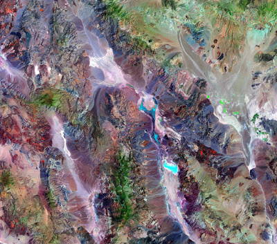
The faulted alluvial fans near Badwater in Death Valley are amongst the most visited and classic landforms in the U.S. New mapping and dating of these landforms, presented in this open-access study by Kurt Frankel and colleagues, help to determine the timing of past earthquakes and how tectonic deformation is distributed across the western U.S.
This in turn provides important data for seismic hazard mitigation and for understanding how the great landscapes of the western U.S. have evolved over recent geologic time.
Death Valley constitutes one of the most dramatic landscapes in North America, and it is famous for its faulted mountain fronts, spectacular alluvial fans, and extensive saline playa. Moreover, the valley is the type example of a pull-apart basin, which is controlled by the northern Death Valley-Fish Lake Valley fault zone, the Black Mountains fault zone, and the southern Death Valley fault zone.
These three fault zones make up the Holocene fault zones of the Death Valley fault system. This Death Valley pull-apart often provides an analog for the evolution, including stress transfer and depositional systems, in other tectonically active transtensional regimes, such as the Dead Sea, East Africa, and Alpine fault of New Zealand.
Reference:
Kurt L. Frankel, Lewis A. Owen, James F. Dolan, Jeffrey R. Knott, Zachery M. Lifton, Robert C. Finkel, Thad Wasklewicz. Timing and rates of Holocene normal faulting along the Black Mountains fault zone, Death Valley, USA. Lithosphere, 2015; L464.1 DOI: 10.1130/L464.1
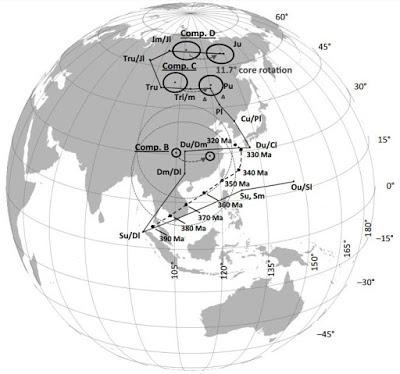
This is a picture of paleomagnetic poles from paleomagnetic directions: Comparison of paleopoles from components A, B, and C from the Marcellus Formation with the apparent polar wander path for North America during the Devonian from Van der Voo (1990, solid line) and Cocks and Torsvik (2011, dashed line). Credit: GSA Bulletin and D. Minguez et al.
The Marcellus Shale is famous as a formation being explored for natural gas resources. That exploration has also offered some insight into an age-old problem: where was the continent of North America 400 million years ago?
In a research partnership between Lehigh University and The Pennsylvania State University, subterranean rock samples have been used to help fill a gap in the history of Earth’s magnetic field, and, as a corollary, places some constraints on the position of North America when the Marcellus Formation was deposited.
Geologists use the magnetizations of rocks, acquired during their formation to determine the positions of continents relative to Earth’s magnetic field. The magnetic record for the Devonian Period (ending roughly 360 million years ago) is rather patchy. This study shows that the Marcellus Formation (of Devonian age), and others like it may be able to fill in those gaps.
Reference:
Paleomagnetism of the Oatka Creek Member of the Marcellus Formation: A Devonian paleopole for North America
D. Minguez et al., Department of Earth and Environmental Science, Lehigh University, 1 W. Packer Avenue, Bethlehem, Pennsylvania 18015, USA. This paper is online at DOI:10.1130/B31291.1
Animals escaping from an erupting volcano 235 million years ago in northwestern Argentina. These species, found as fossils in the Chañares Formation, include early mammal relatives (the dicynodont Dinodontosaurus in the left background, and the cynodont Massetognathus in the left foreground) and early dinosaur precursors (Lewisuchus in the right background, and Lagerpeton in the right foreground). By measuring radioactive isotopes in zircons crystals from the volcanic ash, scientists were able to determine the precise age of this fossil assemblage. Credit: Victor Leshyk
A new study by a team of scientists from Argentina, Brazil, California and the Natural History Museum of Utah at the University of Utah has determined that the time elapsed between the emergence of early dinosaur relatives and the origin of the first dinosaurs is much shorter than previously believed. The discovery not only places a new timeline on the connection between early dinosaur relatives and the first dinosaurs in this particular geologic formation, but also in other formations across the world.
The team, which included Randall Irmis, associate professor and curator of paleontology at the Natural History Museum, employed radioactive isotope measurements to date zircon crystals found in the sediments of the Chañares Formation, which is famous for its fossils of early dinosaur relatives.
The team found that the formation, and therefore the fossils found in it, is 234 to 236 million years old, from the Late Triassic Period; this is 5-10 million years younger than previous estimate of a Middle Triassic age.
“To discover that these early dinosaur relatives were geologically much younger than previously thought was totally unexpected,” said Irmis.
The results were recently published in the Proceedings of the National Academy of Sciences. The lead author is Claudia A. Marsicano from the University of Buenos Aires, and the co-authors are Irmis, Adriana C. Mancuso, Roland Mundil and Farid Chemale.
The Chañares Formation: The quintessential dinosauromorph cemetery
The Chañares Formation is an approximately 75-meter-thick-(250-foot) geologic formation composed of sediments deposited by rivers, streams and lakes during the Triassic Period in present-day La Rioja Province, northwestern Argentina.
“Among Triassic geologic formations containing fossils, the Chañares Formation is a classic. It contains a variety of complete fossil specimens of early dinosauromorphs, which are essentially dinosaur aunts, uncles and cousins,” said Irmis.
“In other basins, dinosaur precursors, early dinosaurs and faunas dominated by dinosaurs do not all conveniently exist in the same place. In the basin containing the Chañares Formation, you can follow hundreds of meters of sediments back through time. Because of this, the margin of error is very narrow because you can see the complete history all in one basin,” said Marsicano, the paper’s lead author.
Today the Chañares Formation’s landscape looks reminiscent of southern Utah — high desert badlands. Back when dinosauromorphs roamed, however, the Chañares Formation was more tropical and lush. At that point in time the Earth was in a hothouse state — extremely warm without any polar ice caps and high levels of carbon dioxide in the atmosphere.
The team collected two rock samples from the Chañares Formation: One from the base of the level where fossils were preserved and one from near the formation’s top.
“The Chañares Formation contains tuffs, or volcanic ashes, that can be dated with great accuracy. So in this basin, not only are there many high-quality, complete fossils that allow us to easily identify taxa, but there are also tuffs in between that allow us to date the entire column,” said Marsicano.
The rock samples include volcanic ash that erupted from volcanoes at the same time the sediments were deposited. The samples were then crushed to extract zircon crystals from this ash.
When these crystals formed during the Triassic Period, they only incorporated uranium; over time, some of this uranium decayed into lead at an exact known rate. By measuring the uranium/lead ratio in each zircon crystal with a mass spectrometer, an instrument that separates elements and isotopes by mass and concentration, the researchers were able to determine the precise date age the crystals formed.
“In a coarse way, you can place fossils in certain time periods, but if you wish to constrain a major evolutionary event, like the beginning of a group or the diversification of a group, the methodology has to have a margin of error that is much smaller. For something that happens over the course of, say, 600 million years, an error of 3-4 million years is not statistically significant. But if something happens over the course 10-12 million years, like the diversification of a group, an error of 3-4 million years is a major problem,” said Marsicano.
“By working with an international group that has the technological capability to date these rocks with great accuracy, we’ve dated the rocks for the first time.”
The radioisotopic dating demonstrated that the base formation sample is no older than 236 million years old and the top layer is no older than 235 million years old, with a possibility of being as young as 234 million years old. This demonstrates that the time elapsed between the appearance of early dinosauromorphs and the origin of dinosaurs is much shorter than previously thought.
Younger dinosauromorphs across the globe
The team’s results also call the timelines of a wide variety of other fossil-bearing formations across the world, all believed to be from the Middle Triassic Period, into question.
The new Late Triassic age for the Chañares Formation may hold true for the Santa Maria Formation in southern Brazil, which shares the same fossil species as the Chañares Formation, and the Karoo sequence in South Africa, to name a few. None of these other formations have been radioisotopically dated.
“We always thought these ‘Middle Triassic’ fossils showed the ecological recovery from the worst mass extinction of all time, the end-Permian extinction, but if these fossils are actually Late Triassic in age, they really have nothing to do with that recovery,” said Irmis.
Major funding for this study was provided by the Ann and Gordon Getty Foundation. Other funding was provided by the Universidad de Buenos Aires (University of Buenos Aires), University of Utah, Consejo Nacional de Investigaciones Científicas y Técnicas (National Scientific and Technical Research Council of Argentina), and Conselho Nacional de Desenvolvimento Científico e Tecnológico (National Council for Scientific and Technological Development of Brazil). Fieldwork was conducted in Talampaya National Park under scientific permits issued by the Administración de Parques Nacionales (National Park Administration of Argentina) and the Province of La Rioja.
Reference:
C.A. Marsicano, R.B. Irmis, A.C. Mancuso, R. Mundil, and F. Chemale. The precise temporal calibration of dinosaur origins. Proceedings of the National Academy of Sciences, 2015 DOI: 10.1073/pnas.1512541112
A new species of toothy pterosaur is a native of Texas whose closest relative is from England.
The new 94-million-year-old species, named Cimoliopterus dunni, is strikingly similar to England’s Cimoliopterus cuvieri.
Identification of the new flying reptile links prehistoric Texas to England, says paleontologist Timothy S. Myers, Southern Methodist University, Dallas, who identified the fossil as a new species.
Pterosaur relatives from two continents suggests the prehistoric creatures moved between North America and England earlier in the Cretaceous—despite progressive widening of the North Atlantic Ocean during that time.
The Texas and English Cimoliopterus cousins are different species, so some evolutionary divergence occurred.
That indicates the populations were isolated from one another at 94 million years ago, Myers said.
The similarity between the two species, however, implies minimal divergence time, so gene flow between North American and European populations would have been possible at some point shortly before that date.
“The Atlantic opened the supercontinent Pangea like a zipper, separating continents and leaving animal populations isolated, so gene flow ceased and we start to see evolutionary divergence,” said Myers, a research assistant professor in the Roy M. Huffington Department of Earth Sciences at SMU. “Animals start to look different and you see different species on one continent versus another. Pterosaurs are a little trickier because unlike land animals they can fly and disperse across bodies of water. The later ones are pretty good flyers.”
Based on fossils discovered so far, it’s known that toothed pterosaurs are generally abundant during the Cretaceous in Asia, Europe and South America. But they are rare in North America.
The new Texas native, Cimoliopterus dunni, is only the third pterosaur species with teeth from the Cretaceous of North America. All three of the toothy Cretaceous-era pterosaurs discovered so far from North America are Texans. Nevertheless, Cimoliopterus dunni is most closely related to England’s Cimoliopterus cuvieri, said Myers.
The Cretaceous spanned about 80 million years from 145 million years ago to 66 million years ago.
Each of the Texas pterosaurs was discovered near Dallas.
Pterosaurs can cross marine barriers between emergent landmasses, effectively ‘island hopping’
Besides the new 94-million-year-old Cimoliopterus dunni, Myers in 2010 identified the 96-million-year-old Aetodactylus halli, a close cousin to Cimoliopterus. The third Texas pterosaur, 105-million-year-old Coloborhynchus wadleighi, was identified in 1994 by then-SMU student Yuong-Nam Lee. It too has an English connection: The first Coloborhynchus species ever described is from England.
“Given the small sample size, it’s odd that we have two that are so closely related to the English species,” Myers said. “It’s hard to draw any statistically significant conclusions from that, but it definitely indicates this is not a one-off, and that there was some relatively strong, significant connection. Two means a lot more than one in this case.”
Myers isn’t suggesting a land bridge. But scientists have suggested the sea level of the North Atlantic fluctuated over time.
“Pterosaurs don’t necessarily need land bridges to disperse because they can cross marine barriers between emergent landmasses, effectively ‘island hopping’ from one continental mass to another,” Myers said.
Nevertheless, identification of the new toothy Texas pterosaur deepens a mystery surrounding the flying reptiles: There still is no evidence of close ties between North American and South American pterosaur populations, he said.
“There are toothed pteranodontoids in South America—lots of individuals and lots of different species—but no close relatives to the toothed pteranodontoids in North America,” he said. “That might indicate there was some barrier to dispersal from the south. It’s unusual we don’t see a connection between these pterosaur populations. Maybe we will when we find more of this material.”
Myers reported the new species in the Journal of Vertebrate Paleontology in “First North American occurrence of the toothed pteranodontoid pterosaur Cimoliopterus.”
A long-lived group, whether toothy and small, or toothless and big
As a group, pterosaurs, which lived alongside dinosaurs, were long-lived. They survived about 162 million years, from the Late Triassic, 228 million years ago, through the Cretaceous, 66 million years ago.
Pterosaurs were among the earliest vertebrates to steadily flap their wings to power their flying.
Early forms were toothy and had wingspans similar to a flying fox, while later they were toothless and as large as fighter jets.
Pterosaurs nested on land but their bones are often recovered from shallow marine rocks. Some species have slender, pointed teeth, suitable for a diet of fish.
“This group is very abundant around the world in the middle Cretaceous—except in North America. The only evidence we have of the toothed members comes from Texas,” Myers said. “In general we see a broad trend in pterosaurs away from teeth, so at the end of the Cretaceous all known species are toothless.”
Pterosaur hunted fish offshore from North America’s Interior Seaway
Cimoliopterus dunni likely hunted fish just off shore in the shallow Western Interior Seaway.
The prehistoric Seaway covered the central United States and Canada, extending from the Gulf of Mexico to the Arctic Ocean.
Myers identified the new pterosaur from a partial upper jaw—specifically the tip of the blunt snout, or rostrum. The rostrum has sockets for 13 pair of teeth. Atop the snout is a thin, prominent crest that starts near the front and extends back. The crest is fully fused to the jaw, a good indicator the pterosaur was not a juvenile, Myers said.
“The crest is really striking,” he said. “It’s almost preserved in its entirety.”
Prolific amateur collector Brent Dunn discovered the upper jaw in January 2013 while walking the spillway of Lake Lewisville north of Dallas. The fossil, coated in reddish mud, had weathered out of the ground. The marine shale layer in which it was found is part of the Eagle Ford Group, a rock unit unique to Texas.
The fossil was found alongside ammonites and crustaceans, called index fossils, because they date the shale layer. Ammonites also indicate an open marine environment, with no fresh water influence.
Although Cimoliopterus dunni would have been large, it was mid-sized as pterosaurs go, with a wingspan of about 6 feet.
“It wouldn’t have been small and cute,” Myers said. “You would have thought twice about approaching it.”
It’s fortunate to have the beautifully preserved fossil because the potential for preserving pterosaur bones is low, Myers said. Their bones were light and hollow, filled with vacuities to help them fly, so they tend to crush easily and break into pieces. “So their normal cylindrical bone is pancaked flat,” he said.
Dunn, a long-time member of the Dallas Paleontological Society, donated it to SMU’s Shuler Museum of Paleontology. He died in 2013. Myers named the fossil for Dunn.
Video
A new species of toothy pterosaur is a native of Texas, but is strikingly similar to an English species.
Named Cimoliopterus dunni, the new pterosaur’s closest cousin is England’s Cimoliopterus cuvieri.
Identification of the 94-million-year-old flying marine reptile links prehistoric Texas to England, says paleontologist Timothy Myers, Southern Methodist University, Dallas, and suggests gene flow between the two populations was possible shortly before that date, despite progressive widening of the North Atlantic Ocean.
Reference:
Timothy S. Myers. First North American occurrence of the toothed pteranodontoid pterosaur, Journal of Vertebrate Paleontology (2015). DOI: 10.1080/02724634.2015.1014904
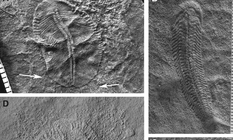
Selected Ediacaran fossils. Credit: (A) Andrej Ivantsov; (B) Jim Gehling; (C) S. J.; (D) Martin Smith; (E) Stefan Bengtson. Credit: Photos courtesy of Uppsala University
The fossil group called the Ediacaran biota have been troubling researchers for a long time. How do these peculiar organisms relate to modern organisms? In a new study, published in Biological Reviews, researchers from Sweden and Spain suggest the Ediacarans reveal previously unexplored pathways taken by animal evolution. They also propose a new way of looking at the effect the Ediacarans might have had on the evolution of other animals.
The fossil record of animals starts for sure by about 540 million years ago, but their origins before this point have remained obscure. Darwin himself worried about this problem at length in the “Origin of species”. But after Darwin was writing, a famous group of fossils were discovered called the Ediacaran biota, named after a remote mine in South Australia where many were found. They are now known to be widespread around the globe from the interval of time just before the animal fossil record starts.
But what are these peculiar organisms? Their very strange morphology has made relating them to modern organisms very difficult, and they have been suggested to be related to anything from plants, fungi and lichens through to recognisable animals such as worms and arthropods.
In a major review of the Ediacaran fossils recently published in Biological Reviews, Graham Budd, professor of palaeobiology in Uppsala University, Sweden, and Sören Jensen, researcher at Badajoz University, Spain, suggest that most of the Ediacarans are very basal representatives of animal lineages, and as such are likely to reveal the hitherto very obscure pathways taken by animal evolution. This goes some way to explain why they happen to appear just before clearly recognisable animals do in the fossil record, and raises the question of what the ecological relationship between the two biotas is.
Traditionally, it has been thought that the more advanced animals, many of which are mobile and can burrow energetically through the sediment, were kept in ecological obscurity by the largely immobile Ediacarans, just as the mammals were by the dinosaurs; and it was not until the Ediacarans all went extinct that the mobile animals could diversify in the so-called “Cambrian explosion”.
Budd and Jensen propose a new view of this relationship however, inspired by the interaction between the vegetation and animals in the modern savannah environments of east Africa. In their new ‘savannah’ hypothesis, they propose that concentration of nutrients both above and below the sediment-water interface were enhanced around the stationary Ediacarans, and the creation of these resource “hot spots” created a very diverse environment, ideal for both diversification and for investment of energy into movement. Rather than the Ediacarans and later animals being direct competitors then, the Ediacarans themselves created a permissive environment that was ideal for higher animals to evolve in. This idea fits well into a modern view of evolution, called “ecosytem engineering” whereby key species (such as beavers) influence the environment in order to create new evolutionary and diversity opportunities for other species. Perhaps then, the Ediacaran taxa weren’t impediments but the drivers of the evolution that was eventually to lead to all the rich animal diversity we see today.
Reference:
Graham E. Budd et al. The origin of the animals and a ‘Savannah’ hypothesis for early bilaterian evolution, Biological Reviews (2015). DOI: 10.1111/brv.12239
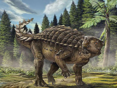
Life reconstruction of Kunbarrasaurus ieversi. Credit: Australian Geographic
It has a parrot-like beak, bones in its skin and an inner ear similar to a turtle. Meet Kunbarrasaurus, Australia’s newest dinosaur.
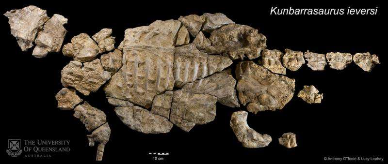
The skeleton of Kunbarrasaurus (koon-ba-rah-sore-rus) was discovered in 1989, but new research from a team led by University of Queensland experts has revealed the dinosaur is a distinctly different species than previously thought.
UQ School of Biological Sciences PhD student Lucy Leahey said the fossil represented the most complete dinosaur so far discovered in Australia and one of the best-preserved ankylosaur fossils in the world.
“Ankylosaurs were a group of four-legged, herbivorous dinosaurs, closely related to stegosaurs,” Ms Leahey said.
“Like crocodiles, they had bones in their skin and are commonly referred to as ‘armoured’ dinosaurs.”
“When it was first studied back in the 1990s, the fossil was placed it in the same genus as Australia’s only other named ankylosaur, Minmi, which is based on some bones from Roma in south-western Queensland.”
The team’s research found the fossil was different to the Roma Minmi, and distinct enough from all other ankylosaurs to warrant a new name.
“Kunbarra is the word for ‘shield’ in the Mayi language of the Wunumara people from the Richmond area, and the species name honours the person who originally found the fossil, Mr Ian Ievers. It means ‘Ievers’ shield lizard,” Ms Leahey said.
Research that started in 2007 involved careful preparation of the palate of the dinosaur at the Denver Museum of Nature and Science, along with CT scanning at the Mater Adult Hospital.
Professor Lawrence Witmer from the Ohio University Heritage College of Osteopathic Medicine used the information to create a 3D reconstruction of the brain, inner ear and nasal cavities, which can be viewed here.
“The CT reconstruction revealed that Kunbarrasaurus had a more complicated airway than other dinosaurs, but less so than ankylosaurs from the Northern Hemisphere,” Professor Witmer said.
“The inner ear is proportionately enormous and unlike anything we have seen before in a dinosaur.
“It looks more like the inner ear of a Tuatara or a turtle. Exactly what the consequences of this are we are still unsure.”
UQ’s Dr Steve Salisbury said the findings made it clear that the Kunbarrasaurus specimen should be considered as a new dinosaur.
“The sheep-sized herbivore formerly known as Minmi sp. is now known to have had a parrot-like beak, breathed through a nasal passage that looped back on itself, and had an inner ear more like a tuatara than a dinosaur,” he said.
“Our work has also revealed that Kunbarrasaurus is more primitive than the majority of other well-known ankylosaurs from North America and Asia.”
“It appears to represent an early, less heavily ‘armoured’ member of the group, close to the point at which the ankylosaurs diverged from the other main lineage of armoured dinosaurs, the stegosaurs.”
The skeleton of Kunbarrasaurus ieversi is on display at the Queensland Museum (Southbank).
The research is available online in the open access journal PeerJ.
The holotype skeleton of Kunbarrasaurus ieversi (QM F18101), Australia’s most complete dinosaur fossil, and one of the world’s most complete ankylosaurians. Credit: Anthony O’Toole and Lucy Leahey
Video
The fossil skull of the ankylosaurian dinosaur Kunbarrasaurus (formerly known as Minmi sp.) from the Early Cretaceous of Australia was CT scanned to allow analysis of the brain endocast, inner ear, and nasal airway. This work was published in PeerJ on 2015-12-08
Reference:
Leahey LG, et al. Cranial osteology of the ankylosaurian dinosaur formerly known as Minmi sp. (Ornithischia: Thyreophora) from the Lower Cretaceous Allaru Mudstone of Richmond, Queensland, Australia. PeerJ 3:e1475 DOI: 10.7717/peerj.1475