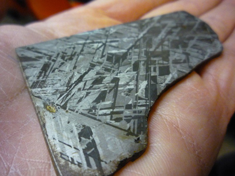
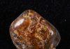
Acid-etched iron meteorite slice, revealing the characteristic Widmanstätten pattern, indicative of slow cooling and crystallization within the iron-nickel cores of larger asteroids. Planetary geologists can track the solar system’s magnetic field environment using magnetizations preserved within meteorites. Credit: Patrick M. Len, Cuesta College Physical Sciences Division, CC BY 2.0
Just over 50 years ago, scientists first theorized that the magnetization of the ocean floor recorded the reversals of Earth’s geomagnetic field, as well as information on the tectonic motion of crustal plates. In just 5 decades, the role of rock magnetism in the geosciences has bloomed dramatically to also include applications to climate and environmental change, biogeoscience, planetary and meteorite evolution, volcanology, soil science, and archaeology. Rock magnetic researchers have made meaningful contributions to all of these disciplines because of an ever-improving ability to describe the magnetic minerals that are present in natural materials.
An important improvement in magnetic characterization has been the development of the first-order reversal curve (FORC) technique, which allows researchers to map out the distribution of magnetic properties of a sample’s magnetic grains, as well as grain-to-grain interactions and intragrain magnetic phenomena. Earth scientists can leverage these high-resolution magnetic data by interpreting them in the context of particular geologic processes, including, for example, mineral transformations, magnetofossil detection, and information on the solar system’s magnetic environment recorded in meteorite minerals.
To discuss the results of recent advancements in the FORC technique and to plan future work, 55 researchers from 13 nations gathered at the University of Minnesota in July for a workshop on first-order reversal curves. The meeting attracted senior and junior researchers from a range of disciplines working in academic, industry, and governmental settings.
Presentations at the meeting provided historical review of the development of the FORC technique, hands-on training for the best practices in collecting and processing FORC data, and case studies on the magnetic behavior of synthetic and geological materials. Perhaps the most important part of the meeting was the identification of three priorities for future research.
First, scientists agreed on the need to continue to develop cross-platform software for processing of FORC data collected on a variety of magnetometers. Second, because the technique is still emerging, continued collaboration between experimentalists (e.g., mineralogists and materials scientists) and theoretical physicists is needed to interpret data correctly. Establishing strong links between trends observed in FORC data and actual geological processes remains an important challenge for Earth scientists.
Finally, scientists across different disciplines need to develop a common language to communicate the importance of their FORC research to one another and the broader scientific community. Improvements in magnetic characterization are a direct result of collaborative efforts among mineralogists, physicists, materials scientists, and engineers. Continued cross-disciplinary forums of this kind will help further collaboration and communication.
The FORC technique is of rapidly growing importance for describing the magnetic minerals in natural and synthetic systems. New and innovative applications continue to develop at a brisk pace, and the research priorities set forward at this meeting aim to provide direction for future magnetic research in the geosciences.
Talks and training videos can be viewed at the meeting website.
Note: The above post is reprinted from materials provided by American Geophysical Union. The original article was written by Joshua M. Feinberg and Leonard Spinu.
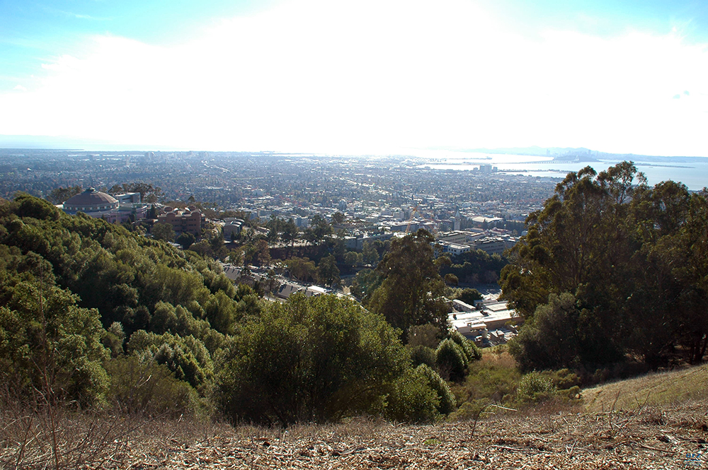
One of the world’s most famous faults: the Californian Andreas Fault, seen here in the Bay area of San Francisco Credit: P. Martínez-Garzón, GFZ
Continental transform faults evolve when two plates slide along each other. The most prominent examples are the San Andreas Fault in California and the North Anatolian Fault in Turkey. Earthquakes along those faults typically do not exceed earthquake magnitudes around M8 but occur at shallow depth thus posing a major threat to nearby metropolitan regions such as San Francisco or Istanbul.
To estimate the seismic hazard and resulting risk it is essential to know the maximum earthquake magnitude to be expected along particular faults. This, however, is not trivial since instrumental recordings date back only 150 years while the recurrence period for the largest earthquakes can be much longer.
A team of scientists from the GFZ German Centre for Geosciences in collaboration with the University of Southern California has now presented a global evaluation of observed maximum earthquakes along all major transform faults allowing to better estimate the maximum earthquake strengths.
The major findings of the study are that for 75% of the data the observed maximum magnitude generally scales with the offset across the faults if exceeding 10 km. The offset across a fault results from the continuous slip of several mm to a few cm per year leading to offsets of kilometers after millions of years. Furthermore, it was found that the length of the rupture of individual earthquakes scales with mapped fault length.
For the remaining 25% of the earthquakes a larger coseismic stress drop was found to occur. ‘This means that those earthquakes release more seismic energy during the rupture process and they all occur along faults with low slip rates allowing to distinguish them from the majority of events that show a direct relation to cumulative offset’ says GFZ-scientist Patricia Martínez-Garzón, lead author of the study.
The results contribute towards developing refined building codes, risk mitigation concepts and early-warning systems and are, thus, of great relevance for millions of people living in population centers near transform faults.
Reference:
Patricia Martínez-Garzón et al. Scaling of maximum observed magnitudes with geometrical and stress properties of strike-slip faults, Geophysical Research Letters (2015). DOI: 10.1002/2015GL066478
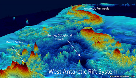
The topography of West Antarctica below the ice sheet as viewed from above, looking toward the Antarctic Peninsula. Much of West Antarctica is a basin that lies below sea level (blue), although it is currently filled with ice, not water. West Antarctica was stretched and thinned as it moved away from East Antarctica, forming one of the world’s largest continental rift systems. Credit: Bedrock Consortium
Planetary scientists would be thrilled if they could peel the Earth like an orange and look at what lies beneath the thin crust. We live on the planet’s cold surface, but the Earth is a solid body and the surface is continually deformed, split, wrinkled and ruptured by the roiling of warmer layers beneath it.
The contrast between the surface and the depth is nowhere starker—or more important—than in Antarctica. What is causing the mysterious line of volcanoes that emerge from the ice sheet there, and what does it mean for the future of the ice?
“Our understanding of what’s going on is really hampered because we can’t see the geology,” said Andrew Lloyd, a graduate student in earth and planetary sciences in Arts & Sciences at Washington University in St. Louis. “We have to turn to geophysical methods, such as seismology, to learn more,” he said.
Lloyd helped deploy research seismometers across the West Antarctic Rift System and Marie Byrd Land in the austral summer of 2009-10. He then returned in late 2011 and snowmobiled more than 1,000 miles, living in a Scott tent, to recover the precious data.
The recordings the instruments made of the reverberations of distant earthquakes from January 2010 to January 2012 were used to create maps of seismic velocities beneath the rift valley. An analysis of the maps was published online in the Journal of Geophysical Research: Solid Earth on Nov. 12, 2015.
This is the first time seismologists have been able to deploy instruments rugged enough to survive a winter in this part of the frozen continent, and so this is the first detailed look at the Earth beneath this region.
Not surprisingly, the maps show a giant blob of superheated rock about 60 miles beneath Mount Sidley, the last of a chain of volcanic mountains in Marie Byrd Land at one end of the transect. More surprisingly, they reveal hot rock beneath the Bentley Subglacial Trench, a deep basin at the other end of the transect.
The Bentley Subglacial Trench is part of the West Antarctic Rift System and hot rock beneath the region indicates that this part of the rift system was active quite recently.
A volcanic mystery
Mount Sidley, the highest volcano in Antarctica, sits directly above a hot region in the mantle, Lloyd said. Mount Sidley is the southernmost mountain in a volcanic mountain range in Marie Byrd Land, a mountainous region dotted with volcanoes near the coast of West Antarctica.
“A line of volcanoes hints there might be a hidden mantle plume, like a blowtorch, beneath the plate,” said Doug Wiens, PhD, professor of earth and planetary sciences and a co-author on the paper. “The volcanoes would pop up in a row as the plate moved over it.”
“But it’s a bit unclear if this is happening here,” he said. We think we know which direction the plate is moving, but the volcanic chain is going in a different direction and two additional nearby volcanic chains are oriented in yet other directions.
“If this was just a plate moving over a couple of mantle plumes, you’d expect them to line up, as they do in the Hawaiian Islands,” he said.
Although the hot zone’s shape is ill-defined, it is clear there is higher heat flow into the base of the ice sheet in this area, Wiens said.
Deeper than the Grand Canyon
The most interesting finding, Lloyd said, is the discovery of a hot zone beneath the Bentley Subglacial Trench.
The basin is part of the West Antarctic Rift System, a series of rifts, adjacent to the Transantarctic Mountains, along which the continent was stretched and thinned.
The old rock of East Antarctica rises well above sea level, but west of the Transantarctic Mountains, extension has pulled the crust into a broad saddle, or rift valley, much of which lies a kilometer below sea level.
“If you removed the ice, West Antarctica would rebound, and most of it would be near sea level. But the narrower and deeper basins might remain below it,” Lloyd said. “The Bentley Subglacial Trench, which is the lowest point on Earth not covered by an ocean, would still be a kilometer and a half below sea level if the ice were removed.”
Because the West Antarctic Rift is hidden, less is known about it than about other famous rift systems such as the East African Rift or, in the United States, the Rio Grande Rift.
“We didn’t know what we’d find beneath the basin,” Wiens said. “For all we knew it would be old and cold.
“We didn’t detect any earthquakes, so we don’t think the rift is currently active, but the heat suggests rifting stopped quite recently.”
In this way, it resembles the Rio Grande Rift, which is also no longer active but has yet to cool completely.
A period of diffuse extension created the rift valley in the late Cretaceous, roughly 100 million years ago, Lloyd said, and more focused extension then created deep basins like the Bentley Subglacial Basin and the Terror Rift in the Ross Sea.
“This period of more focused extension likely occurred in the Neogene,” Lloyd said. “If it’s still hot there, it might also be hot under other basins in the rift system.”
Will the heat flow grease the skids?
The rift system is thought to have a major influence on ice streams in West Antarctica. “Rifting and ice flow occur on completely different time scales,” Lloyd said, “so rifting is not going to suddenly make the ice sheet unstable.
“But to accurately model how quickly the ice is going to flow or the rock to rebound, we need to understand the ‘boundary conditions’ for ice models, such as heat flow from the mantle,” he said.
“Seismic surveys like this one will help inform models of the ice sheet,” Wiens said. “Modelers need an estimate of the heat flow, and they need to know something about the geological conditions at the bottom of the ice sheet in order to estimate drag. Right now, both of these factors are very poorly constrained.”
While heat flow through the Earth’s crust has been measured at at least 34,000 different spots around the globe, in Antarctica it has been measured in less than a dozen places. In July 2015, scientists reported the heat flow at one of these spots was four times higher than the global average.
Ever since then, scientists have been wondering why the reading was so high. “Recent extension in the Bentley Subglacial Trench might explain these readings,” Wiens said.
The next big problem, he said, is to understand the structure under the Thwaites and Pine Island glaciers, which lie closer to the coastline than the Bentley Subglacial Trench. These two glaciers have been described as the ‘weak underbelly’ of the ice sheet because surges in the ice flow there could theoretically cause the rapid disintegration of the entire West Antarctic ice sheet.
During the 2014-2015 Antarctic field season, Lloyd helped deploy another 10 seismic stations that together with seismometers deployed by the British will map the underside of this key area.
Reference:
Andrew J. Lloyd, Douglas A. Wiens, Andrew A. Nyblade, Sridhar Anandakrishnan, Richard C. Aster, Audrey D. Huerta. A seismic transect across West Antarctica: Evidence for mantle thermal anomalies beneath the Bentley Subglacial Trench and the Marie Byrd Land Dome. DOI: 10.1002/2015JB012455
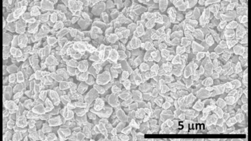
This is a scanning electron microscopy image of microdiamonds made using the new technique.
Researchers from North Carolina State University have discovered a new phase of solid carbon, called Q-carbon, which is distinct from the known phases of graphite and diamond. They have also developed a technique for using Q-carbon to make diamond-related structures at room temperature and at ambient atmospheric pressure in air.
Phases are distinct forms of the same material. Graphite is one of the solid phases of carbon; diamond is another.
“We’ve now created a third solid phase of carbon,” says Jay Narayan, the John C. Fan Distinguished Chair Professor of Materials Science and Engineering at NC State and lead author of three papers describing the work. “The only place it may be found in the natural world would be possibly in the core of some planets.”
Q-carbon has some unusual characteristics. For one thing, it is ferromagnetic – which other solid forms of carbon are not.
“We didn’t even think that was possible,” Narayan says.
In addition, Q-carbon is harder than diamond, and glows when exposed to even low levels of energy.
“Q-carbon’s strength and low work-function – its willingness to release electrons – make it very promising for developing new electronic display technologies,” Narayan says.
But Q-carbon can also be used to create a variety of single-crystal diamond objects. To understand that, you have to understand the process for creating Q-carbon.
Researchers start with a substrate, such as such as sapphire, glass or a plastic polymer. The substrate is then coated with amorphous carbon – elemental carbon that, unlike graphite or diamond, does not have a regular, well-defined crystalline structure. The carbon is then hit with a single laser pulse lasting approximately 200 nanoseconds. During this pulse, the temperature of the carbon is raised to 4,000 Kelvin (or around 3,727 degrees Celsius) and then rapidly cooled. This operation takes place at one atmosphere – the same pressure as the surrounding air.
The end result is a film of Q-carbon, and researchers can control the process to make films between 20 nanometers and 500 nanometers thick.
By using different substrates and changing the duration of the laser pulse, the researchers can also control how quickly the carbon cools. By changing the rate of cooling, they are able to create diamond structures within the Q-carbon.
“We can create diamond nanoneedles or microneedles, nanodots, or large-area diamond films, with applications for drug delivery, industrial processes and for creating high-temperature switches and power electronics,” Narayan says. “These diamond objects have a single-crystalline structure, making them stronger than polycrystalline materials. And it is all done at room temperature and at ambient atmosphere – we’re basically using a laser like the ones used for laser eye surgery. So, not only does this allow us to develop new applications, but the process itself is relatively inexpensive.”
And, if researchers want to convert more of the Q-carbon to diamond, they can simply repeat the laser-pulse/cooling process.
If Q-carbon is harder than diamond, why would someone want to make diamond nanodots instead of Q-carbon ones? Because we still have a lot to learn about this new material.
“We can make Q-carbon films, and we’re learning its properties, but we are still in the early stages of understanding how to manipulate it,” Narayan says. “We know a lot about diamond, so we can make diamond nanodots. We don’t yet know how to make Q-carbon nanodots or microneedles. That’s something we’re working on.”
NC State has filed two provisional patents on the Q-carbon and diamond creation techniques.
Reference:
Jagdish Narayan and Anagh Bhaumik, North Carolina State University. “Novel Phase of Carbon, Ferromagnetism and Conversion into Diamond”. DOI: 10.1063/1.4936595
Jagdish Narayan and Anagh Bhaumik, North Carolina State University. “Direct conversion of amorphous carbon into diamond at ambient pressures and temperatures in air”. DOI: 10.1063/1.4932622
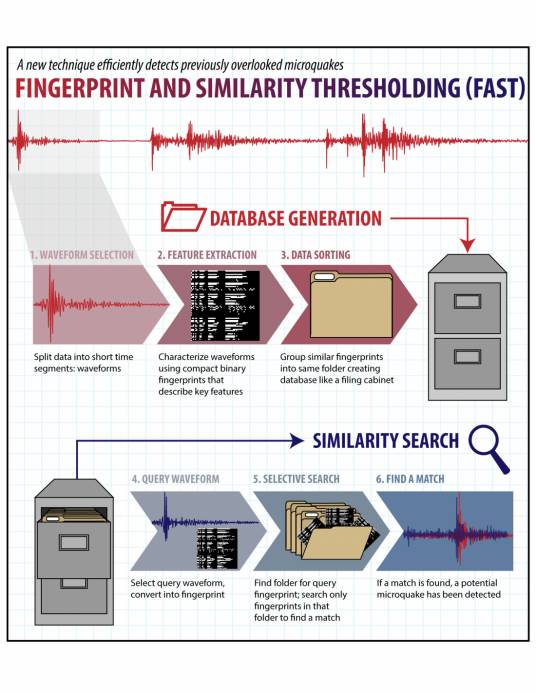
An illustration of how FAST works. Credit: Ilissa Ocko/Stanford University
An algorithm inspired by a popular song-matching app is helping Stanford scientists find previously overlooked earthquakes in large databases of ground motion measurements.
They call their algorithm Fingerprint And Similarity Thresholding, or FAST, and it could transform how seismologists detect microquakes — temblors that don’t pack enough punch to register as earthquakes when analyzed by conventional methods. While microquakes don’t threaten buildings or people, monitoring them could help scientists predict how frequently, and where, larger quakes are likely to occur.
“In the past decade or so, one of the major trends in seismology has been the use of waveform similarity to find weakly recorded earthquakes,” said Greg Beroza, a professor of geophysics at Stanford School of Earth, Energy & Environmental Sciences.
The technique most commonly employed to do this, called template matching, functions by comparing an earthquake’s seismic wave pattern against previously recorded wave signatures in a database. The downsides of template matching are that it can be time-consuming and that it requires seismologists to have a clear idea of the signal they are looking for ahead of time.
The FAST technique, which is detailed in the current issue of the journal Science Advances, circumvents both of these shortcomings by taking all of the recorded data from a seismic station and chopping the continuous signal into segments of a few seconds each. The signals are then compressed into compact representations, or “fingerprints,” for rapid processing.
The fingerprints are then sorted into separate bins, or groups, based on their similarities.
“We then search for pairs of fingerprints that are similar, and then map those back to the time windows that they came from,” said study co-author Clara Yoon, a graduate student in Beroza’s research group. “That’s how we identify the earthquakes.”
Earthquakes occurring on the same section of a fault have similar fingerprints, regardless of their magnitudes, because the seismic waves they generate travel through the same underground structures to reach the surface.
“It doesn’t matter if one earthquake happened 10 years ago and the other one happened yesterday. They’re actually going to have waveforms that look very similar,” Yoon said.
This sorting step, which the Stanford scientists compare to grouping similar documents in a filing cabinet, is why FAST is so efficient.
“Instead of comparing a signal to every other signal in the database, most of which are noise and not associated with any earthquakes at all, FAST compares like with like,” said Beroza, who is the Wayne Loel Professor at Stanford. “Tests we have done on a 6-month data set show that FAST finds matches about 3,000 times faster than conventional techniques. Larger data sets should show an even greater advantage.”
Eureka moment
The idea for FAST occurred to Beroza several years ago. While perusing an electronics store, he heard a catchy song he didn’t know playing over the speakers. Beroza pulled out his smartphone and opened Shazam, an app that could listen to and identify the song by name.
“Shazam did its thing and within 10 seconds it was trying to sell me the song,” Beroza said. In a moment of insight, Beroza realized that Shazam wasn’t simply comparing the digital file of the song against other files in a database. It was doing something more sophisticated, namely capturing the audio waveform of a short section of the song and comparing that snippet to other waveforms housed on an online server. Not only that, the app had to be able to quickly filter out irrelevant noise from the environment such as people’s conversations.
“I thought, ‘That’s cool,’ and then a moment later, ‘That’s what I want to do with seismology,'” Beroza said.
It took several years, but Beroza eventually assembled a team of computer-savvy researchers to help build upon his eureka moment. Drawing heavily upon recent advances in computer science, the group created a search algorithm capable of quickly scanning continuous ground motion data for similar matches.
“In the early stages, we thought that we were going to need high-performance supercomputers to tackle the problem in a brute force fashion by running thousands of comparisons at once,” said study co-author Ossian O’Reilly, a graduate student in the Department of Geophysics. “But we soon realized that even they wouldn’t be able to handle the amount of data we wanted to process. So we started learning about the ingenious algorithms devised by the computer science community for solving related problems.”
In particular, the team borrowed techniques from data mining and machine learning to create FAST, said study co-author Karianne Bergen, a graduate student at Stanford’s Institute for Computational and Mathematical Engineering (ICME).
“The scalability of FAST comes from the use of a data mining technique called locality-sensitive hashing, or LSH,” Bergen said. “LSH is a widely used technique for identifying similar items in large data sets. FAST is the first use of LSH in earthquake detection.”
Testing FAST
In the new study, the Stanford scientists used FAST to analyze a week’s worth of data collected in 2011 by a seismic station on the Calaveras Fault in California’s Bay Area. This same fault recently ruptured and set off a sequence of hundreds of small quakes.
Not only did FAST detect the known earthquakes, it also discovered several dozen weak quakes that had previously been overlooked.
“A lot of the newer earthquakes that we found were magnitude 1 or below, so that tells us our technique is really sensitive,” Yoon said. “FAST was able to spot the missed quakes because it looks for similar wave patterns across the seismic data, regardless of their energy level.”
The team thinks FAST could prove useful in places like Oklahoma and Arkansas, which have recently experienced spikes in suspected induced earthquakes due to the increased injection of wastewater from oil and gas development into the subsurface. “If you can detect the smaller quakes, you could identify the risk of a larger quake occurring from continued injection,” Yoon said.
Similarly, an improved understanding of how often different magnitude earthquakes happen could help seismologists better predict how frequently large, natural quakes will occur.
The team is currently working on scaling up their FAST algorithm to analyze data collected across longer periods of time, from multiple seismic stations and in more challenging scenarios.
“That is very important if you want to be able to determine the location of these earthquakes,” Yoon said. “If you have data from only one station, you can’t accurately pinpoint the epicenter of a quake.”
Reference:
Clara E. Yoon, Ossian O’Reilly, Karianne J. Bergen, Gregory C. Beroza. Earthquake detection through computationally efficient similarity search. Science Advances, 2015: e1501057 DOI: 10.1126/sciadv.1501057
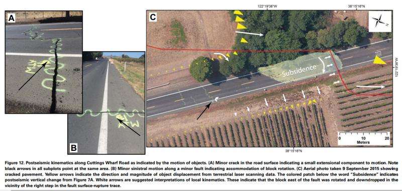
Postseismic kinematics along Cuttings Wharf Road as indicated by the motion of objects. Click on the image for a larger version. Credit: Geosphere, USGS, and DeLong et al.
U.S. Geological Survey scientists used 3D laser scanning to make repeat measurements of an area affected by the 2014 magnitude 6.0 South Napa earthquake in order to define in great detail the surface deformation that occurred both during and after the earthquake. The recent revolution in 3D laser measurement technology (LiDAR) allows scientists to collect detailed information about the shape of the land surface and the objects that sit upon it with unprecedented accuracy.
These spatially extensive measurement techniques provide new understanding of how earthquakes and other phenomena deform the shape of Earth’s surface, reinforce the notion that not all surface deformation occurs during an earthquake itself, and provide insight into what can be expected following future earthquakes. When earthquakes strike, damage is expected to occur along the fault trace over a few seconds or perhaps minutes as Earth’s tectonic plates shift, shake, and tear the ground.
However, in some cases, the damage to Earth’s crust and what sits on top of it can unfold slowly over hours, days, weeks, and even years following an earthquake. This is often termed “afterslip.” and it has been observed following many moderate earthquakes. Surface deformation following the South Napa quake occurred variously as discrete fault slip, rotation of a block of earth adjacent to the fault, and by vertical elevation changes. Comparison of the new 2014 terrestrial laser scanner data with 2003 airborne laser scanner data also indicate that the earthquake caused vertical warping across the fault zone rather than forming a distinct vertical scarp, challenging notions of how topography is created in moderate earthquakes.
Reference:
Stephen B. DeLong, James J. Lienkaemper, Alexandra J. Pickering, Nikita N. Avdievitch. Rates and patterns of surface deformation from laser scanning following the South Napa earthquake, California. Geosphere, 2015; GES01189.1 DOI: 10.1130/GES01189.1
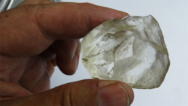
A replica of the Lesotho Promise diamond. Credit: Russell Shor/GIA
Eight years ago, a worker pulled a huge crystal from the sorting area of the Letseng Mine in Lesotho. The rough diamond weighed in at just over 603 carats (cts), making it the 15th largest ever found by anyone, anywhere. The mine’s majority owner, London-based Gem Diamonds, named it the Lesotho Promise in recognition of the nation from whose soil it was unearthed.
For Mazvi Maharasoa, CEO of Letseng Diamonds, a partner in the mine, that diamond and the three 450 ct-plus diamonds that have been found there since are more than a promise—they are a source of national pride and a promise realized.
“This mine is unique, producing the highest average value diamonds ($2,043 per ct, against the global average of $106 per ct) in the world,” she says. “Lesotho is a dot on the map to some people, but these diamonds have brought us recognition.”
The mine is also one of the world’s largest sources of highly coveted type IIa diamonds. Normally, such stones comprise about 2% of diamonds recovered worldwide, but at Letseng, they are about one-quarter of the output.
Touring the mine, located about 3,100 meters (just over 10,000 feet) high in rugged mountain country, Maharasoa notes, “This mine came from nothing in 2000. Now we have 1,500 employees (and) a mine that gives our country 70% of its corporate tax revenue and 60% of our country’s foreign exchange earnings.”
Maharasoa was born in the capital city of Maseru and earned a degree in international and commercial law from the University of Buckinghamshire, north of London. She returned to Lesotho as legal advisor to the Ministry of Natural Resources.
“This is when I became acquainted with the diamond area,” she says, adding that negotiations over changes in the diamond laws and a new contract to restart Letseng were part of her work.
Restarting production at the mine was a challenge. The kimberlite was discovered in 1957 by South African geologist Peter Nixon deep in the Maluti Mountains, amid farming villages and shepherd huts where it seemed that time had stood still for a millennium. It wasn’t until the following year that two South African prospectors, Keith Whitlock and Jack Scott, set out in search of diamonds. They endured extreme cold and blizzards and returned with about 1,800 cts of diamonds.
For several years, the government allowed artisanal miners to file claims and work the site, but in 1968, it invited the mining giant RTZ (now Rio Tinto) to prospect the area. The company worked to develop the mine for four years but determined that the grade of the ore (less than two cts per 100
tons) was too low to mine profitably.
After RTZ moved on, the government invited then-De Beers chairman Harry Oppenheimer to have a look. As a result of his visit, De Beers set up a limited operation, mining the richest areas of the main kimberlite for almost a decade before closing it in 1982 when the global diamond industry fell into a deep crisis.
The site sat fallow for almost 20 years. Several companies leased it but couldn’t find a way to make a profit. Political instability in Maseru did not help, especially when it exploded into violence in 1998, which destroyed much of the capital and several surrounding towns.
When peace was restored the following year, the factions formed a unified government, which decided to restart Letseng to get funds flowing into the national treasury. It created the Letseng Diamond Company to acquire the mining lease from the South African gold mining firm that had held it for several years. It took five years to resume small-scale production—less than 40,000 cts per year.
By 2004, Maharasoa had become an executive with the Central Bank of Lesotho, which was working with the government on a deal for Gem Diamonds to acquire a 70% interest in the mine. “The (kimberlite) pipes at the mine were never properly explored, so there was a lot of work to do,” she says. “And even now, (there is) still a lot of work remaining.”
The Lesotho Promise turned up shortly after Gem Diamonds resumed mining operations in 2006. The company sold it for $12.4 million to Safdico, the South African polishing firm majority-owned by London-based jeweler Laurence Graff.
Graff’s cutters spent a year working on the Lesotho Promise. While potentially D-color, it was dappled with black inclusions, making the planning process look more like a battle map, according to a video Graff produced about cutting the diamond.
Twenty-six GIA-graded D-color Flawless diamonds were cut from it, the largest of them a 76.41 ct pear shape graduating down to a 0.55 ct round brilliant. Graff inscribed serial numbers on each of them to indicate their origin. All 26 diamonds were used to design a necklace with a total weight of 223 cts.
By the time Maharasoa joined Letseng in 2009 as CEO, the company had unearthed the 493 ct Letseng Legacy (2007) that Graff/Safdico purchased for $10 million and the 478 ct Light of Letseng (2008), which yielded the 102.79 ct Graff Constellation (2009), which was graded by GIA and according to Graff is the largest known D-Flawless round brilliant diamond.
Shortly after her arrival, the company announced that it had found two colorless diamonds weighing 196 and 184 cts. In September 2014, the company sold a 198 ct potentially D-Flawless diamond at its Antwerp sale for $10.6 million. These finds have helped seal Letseng’s global reputation as a supplier of large, fine diamonds.
Mining here remains challenging, Maharasoa says.
“It is the world’s highest active diamond mine, so the weather is extremely volatile, going down to –25°C in winter,” she says. “We have to maintain our part of the road that not only supplies us with access to and from the mine, but links the town of Mokhotlong to the north of us.”
Supplying the mine with food, fuel and equipment is no small logistical matter, either.
“We use 1.5 million liters of fuel each month, which all has to come by truck,” Maharasoa says. “And then there’s the challenge of getting our 50-ton Caterpillar mining trucks up the mountains to our site.”
Despite these demands, Gem Diamonds has more than doubled the mine’s production in five years to about 100,000 cts a year.
“Letseng has a long life ahead,” Maharasoa says. “We have established a goal that Lesotho’s diamonds, now supplying about 7.5% of our country’s GDP, can achieve 15% within a few years.”
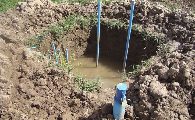
Artificial pits were made to simulate the permanent wetlands within the variable wetland site. Credit: Scott Fendorf
Groundwater in South and Southeast Asia commonly contains concentrations of arsenic 20 to 100 times greater than the World Health Organization’s recommended limit, resulting in more than 100 million people being poisoned by drinking arsenic-laced water in Bangladesh, Cambodia, India, Myanmar, Vietnam and China.
Stanford scientists have solved an important mystery about where the microbes responsible for releasing dangerous arsenic into groundwater in Southeast Asia get their food. Their findings, published in the journal Nature Geosciences, could guide future land management and future development.
Arsenic is bound to iron oxide compounds in rocks from the Himalayas, and gets washed down the major rivers and deposited in the lowland basins and deltas. Scientists know that in the absence of oxygen, some bacteria living in those deposited sediments can use arsenic and iron oxide particles as an alternative means of respiration. When they do this, however, the microbes separate the arsenic and iron oxides and transfer the toxin into underlying groundwater.
The mystery in this system, though, is an obvious source of energy that the microbes can tap to fuel the separation process.
“The question that really limits our ability to come up with predictive models of groundwater arsenic concentrations is how and why does the food they use vary across the landscape and with sediment depth,” said Earth system scientist Scott Fendorf, a professor at Stanford’s School of Earth, Energy & Environmental Sciences.
Field experiments
In their study, Fendorf and his team wanted to determine if the arsenic-releasing microbes were feeding on recent deposits of plant material located near the surface, or whether they were tapping into older biomaterial buried deeper in the subsurface. A second question they wanted to answer was, How does arsenic release vary across the landscape in Asia?
To address these questions, Fendorf and his team performed a series of field experiments. They collected sediment cores from two types of environments in the Mekong Delta in Cambodia: seasonal wetlands – where the soil is saturated by rainwater for only part of the year – and permanent wetlands, which are continually inundated.
“We focused on wetlands because that is the dominant type of landscape found in Cambodia, Vietnam and other countries affected by arsenic contamination,” said Fendorf, who is the Huffington Family Professor in Earth Sciences and also a senior fellow, by courtesy, at the Stanford Woods Institute for the Environment.
Mixing sediments collected from different depths in vials with artificial groundwater revealed that the oxygen-deprived bacteria living in the upper few feet of permanent wetlands were releasing arsenic. However, water mixed with sediments gathered from the same shallow layers of seasonal wetlands was arsenic free.
The Stanford scientists hypothesized that bacteria residing in the shallow layers of seasonal wetlands were eating all of the digestible plant material during dry periods, when sediments are exposed to air and the microbes have access to oxygen. As a result, no food is left for the microbes when the floods returned, rendering them unable to cleave arsenic particles from iron oxides.
This hypothesis was confirmed when the scientists added glucose – a carbon-rich and easily digestible sugar – to the seasonal wetland vial and the microbes began releasing arsenic.
“The arsenic-releasing bacteria living in the shallow regions of seasonal wetlands are ‘reactive’ carbon limited – that is, they don’t release arsenic into the water because there isn’t enough carbon available in a form they can use,” Fendorf said.
The same experiment repeated with samples taken from about 100 feet underground – the depth of most drinking wells in Asia – showed that bacteria living deep beneath permanent and seasonal wetlands are similarly limited and and do not release arsenic into groundwater under normal conditions. The careful sleuthing has identified the bacteria in the permanent wetlands as the primary culprit of arsenic release.
Effects of land development
The work suggests that, under normal conditions, microbes in seasonal wetlands don’t pose a significant threat for adding arsenic to groundwater. But what if the conditions changed, the scientists wondered, as could happen when the land is developed for other uses?
To answer this question, the team conducted a second type of experiment, in which they simulated the conversion of a small, remote seasonal wetland into a permanent one by digging out a seasonal wetland plot and keeping it permanently filled with water. As predicted, this resulted in the release of arsenic. (The amount was small and transient, Fendorf said, and people were never threatened by the experiment.)
The findings have large-scale implications for projecting changes in arsenic concentrations with land development in South and Southeast Asia and for the terrestrial carbon cycle.
“If you change the hydrology of a region by building dams or levies that change the course of the water, or if you change agricultural practices and introduce oxygen or nitrate into sediments where they didn’t exist before, that will alter the release of arsenic,” Fendorf said.
Reference:
Jason W. Stuckey et al. Arsenic release metabolically limited to permanently water-saturated soil in Mekong Delta, Nature Geoscience (2015). DOI: 10.1038/ngeo2589
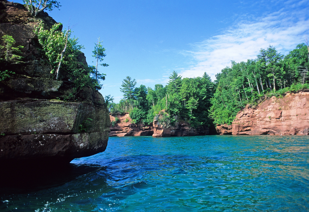
Lakeside cliffs of Stockton Island, part of the Apostle Islands National Lakeshore. 1997
Husband-and wife geologists Seth and Carol Stein have spent many vacations enjoying the recreational wonders of Lake Superior and the surrounding area. Now they are putting their scholarly know-how to work in a serious quest to understand the 1.1 billion-year-old secrets of Lake Superior and the mysterious Midcontinent Rift.
Seth Stein, the William Deering Professor in Northwestern’s department of Earth and planetary sciences in the Weinberg College of Arts and Sciences, and Carol Stein, professor of Earth and environmental sciences at the University of Illinois at Chicago, are working with colleagues to share the amazing story behind the scenery.
The Steins and their colleagues teamed up with Abigail M. Foerstner, chair of the news reporting department at Northwestern’s Medill School of Journalism, Media, Integrated Marketing Communications, to produce an educational video. Working with her and Medill graduate student videographers Lizz Giordano and Jia You, the Steins led a filming journey to some of the area’s most scenic sites.
Lake Superior is where it is because of the Midwest’s biggest geological feature: the Midcontinent Rift, an ancient and giant 2,000-mile-long underground crack that starts in Lake Superior and runs south to Oklahoma and to Alabama.
Some 1.1 billion years ago — long before dinosaurs roamed the Earth — North America started to split apart along the rift, and volcanic rocks poured out and filled the deep valley. For some reason, instead of splitting the continent, the rift died, leaving today’s beautiful scenery.
“It’s funny — although Carol and I have often gone up to Lake Superior for vacations, we didn’t think much about the geology,” Seth Stein mused. “But after I helped start EarthScope, a huge National Science Foundation program to study North America, we and colleagues at Northwestern and other schools got interested in learning more about the rift. In the past few years, we’ve been working together to learn a lot more about how the rift started, grew and died.”
The video explains how the rift’s geology produced both the scenery and its geoheritage — how it shaped the area’s culture and growth. The rift’s geology is why Lake Superior — the area’s original transportation system — is where it is. Rift copper deposits drove European settlement, and rift scenery draws today’s tourists.
“Behind the beauty, there’s an incredible geological story few people realize,” Carol Stein said.
The film crew interviewed other experts, including Northwestern archeologist James A. Brown, who explained how Native Americans all over the Midwest used copper from the rift’s volcanic rocks.
“When we tell people about the rift, they’re interested and surprised,” Seth Stein said. “Most visitors and even people living around Lake Superior have no idea about the story behind the scenery. I’ve often drawn pictures in the sand around campfires explaining the rift.”
Video
The video, produced with National Science Foundation funding, will be made available to national and state park visitors’ centers, teachers, kayak outfitters, museums, universities and other venues.
Professor Ewan Fordyce. Credit: Image courtesy of University of Otago
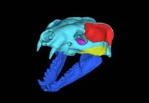
A new species of fossil baleen whale that lived in the North Pacific Ocean 30 to 33 million years ago has been described by researchers from New Zealand’s University of Otago.
The whale, named Fucaia buelli by the researchers, is transitional between ancient toothed whales and the baleen whales of modern seas. It is one of the oldest baleen whales ever found and, at a length of about 2-2.5m, also one of the smallest.
The fossil, which was recovered from Olympic Peninsula, Washington State, USA, is described in a newly published paper in the UK journal Royal Society Open Science.
Paper co-author Dr Felix Marx says that unlike its living baleen whale relatives, which use comb-like baleen plates to filter krill from the surrounding water, Fucaia had well-developed teeth which it used to actively hunt and chew its prey.
“Once captured, prey was likely sucked deeper into the mouth for swallowing — a technique which, ultimately, may have given rise to baleen and filter feeding in the modern Mysticeti suborder of whales,” Dr Marx says.
Dr Marx and his co-authors Dr C.H. Tsai and Professor Ewan Fordyce say that the fossil sheds new light on one of the big questions in mammalian evolution; how, when and why did modern baleen whales lose their teeth?
The complex teeth in Fucaia, and distinctive wear patterns, show that Fucaia likely chewed its food. Long-based and closely-spaced teeth in the jaw leave little room for baleen, but there are some indications that Fucaia perhaps had enlarged gums.
“We think that Fucaia was similar to modern dolphins in capturing its prey using its teeth and perhaps strong suction. Suction feeding likely enabled early whales to move from a tooth-based feeding style to filter-feeding, by allowing them to capture smaller prey items than teeth alone could handle,” Dr Marx says.
The researchers note that suction feeding can still be seen in living grey whales.
“This behaviour may have prompted the evolution of baleen from the enlarged gums, possibly as a more efficient way to expel the water sucked in with the food. As the prey became smaller, teeth became increasingly obsolete and, ultimately, were lost completely in modern baleen whales,” says Professor Fordyce.
Background information:
What is it?
A fossil partial skull, teeth, and associated skeleton of a small toothed whale, estimated 2-2.5 m long. This tiny whale was an adult individual, judging from fused bones in the skeleton.
The species is new to science, and is named Fucaia buelli. Fucaia is named after the Strait of Juan da Fuca, in honour of its origin along the shores of those waters. Its second name, buelli, honours the exceptional illustrations of extinct whales produced by palaeo-artist Carl Buell.
Fucaia belongs in a well-known extinct group, the family Aetiocetidae. (There is no common name for that group, but the meaning is roughly “beginning whale.”) Such animals are transitional between toothed archaic whales and modern baleen whales.
The specimen is from the Burke Museum of Natural History and Culture, at the University of Washington, Seattle, Washington, USA.
How did it live?
Fucaia was probably an active hunter. It may have used suction to “vacuum” small prey into its mouth. Wear patterns on the teeth indicate that Fucaia used its teeth to secure and chew its food. The small body size suggests that the species had a limited range, and did not migrate like the large whales of modern oceans.
Where was the fossil found?
The single known specimen of Fucaia buelli is from a shoreline outcrop on the north coast of the Olympic Peninsula, Washington State.
When did the whale live?
Fucaia buelli lived early in Oligocene times, some 33-31 million years ago. At that time, the region that is now Olympic Peninsula was under-sea. At a global scale, this was a time of climate change. The earth changed from warm and even tropical “greenhouse” conditions to cooler “icehouse” conditions which saw ice-caps develop on Antarctica.
How was the fossil extracted?
In the lab, the fossil was extracted from its surrounding matrix using pneumatic chisels and dilute acid. The preparation was carried out at the Burke Museum, University of Washington, and at the University of Otago, Dunedin, New Zealand.
Reference:
Felix G. Marx, Cheng-Hsiu Tsai, R. Ewan Fordyce. A new Early Oligocene toothed ‘baleen’ whale (Mysticeti: Aetiocetidae) from western North America: one of the oldest and the smallest. Royal Society Open Science, 2015 DOI: 10.1098/rsos.150476
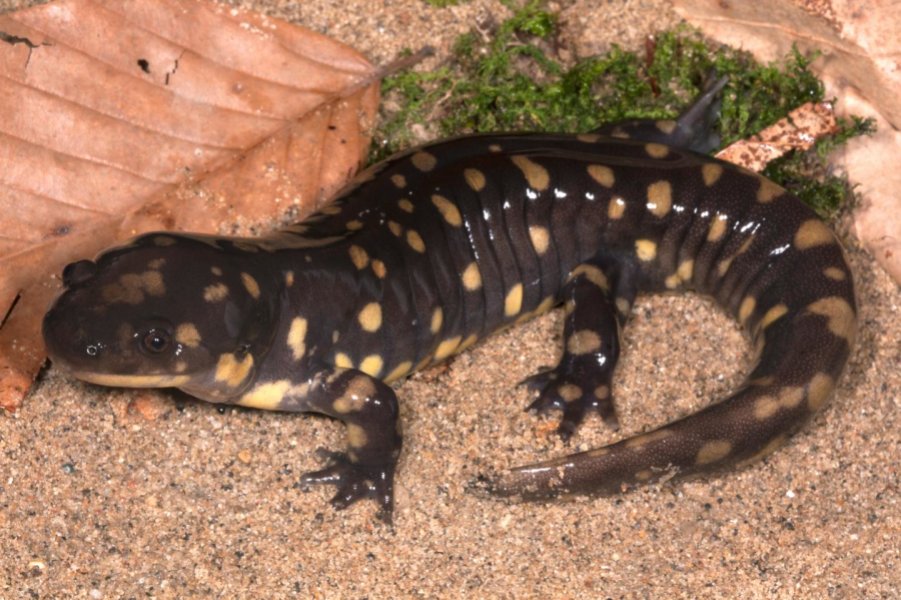
Scientists use the tiger salamander to investigate the stresses that early tetrapods experienced as they moved from water to land. Credit: Todd Pierson
Around 390 million years ago, the first vertebrate animals moved from water onto land, necessitating changes in their musculoskeletal systems to permit a terrestrial life. Forelimbs and hind limbs of the first tetrapods evolved to support more weight. But what specific mechanisms drove changes in bone function?
The tiger salamander might provide some clues. A new study from a team of scientists from the National Institute for Mathematical and Biological Synthesis (NIMBioS) and Clemson University evaluates what mechanisms drive diversity in bone function, providing new insight into the evolution of how tetrapods–the earliest four-legged vertebrate animals–took their first steps on land.
In order to understand the biology of fossilized animals, researchers often turn to living animals with similarities that help model how extinct animals moved. Salamanders are particularly good organisms for studying how locomotion onto land evolved, as their anatomy and ecology is similar to the earliest tetrapods.
Bones must regularly withstand a variety of different forces, or “loads,” from both the contraction of muscles and from interaction with the environment. Limb bones in particular must accommodate some of the highest forces. Fossil records suggest that the forelimb and hind limb may have had different functions for walking on land, but the specific mechanisms that contributed to these differences are less known. The researchers wanted to test what factors could have driven diversity in skeletal design in the evolution of early tetrapods.
The mechanics of bone loading in the salamanders were tested in a variety of ways, including filming the salamanders as they walked across a custom-built platform that measured forces on the limb bones. A comparison of forelimbs and hind limbs and an analysis of limb joints were conducted. Mathematical models were used to evaluate how the limb bones were able to withstand the physical demands of walking on land.
To assure a good test, salamanders that turned, stopped or fell on the platform or walked diagonally, for example, were excluded from the study. The study found that the forelimbs, compared to the hind limbs, had lower yield stresses, higher mechanical hardness, and a greater ability to withstand loads higher than normal.
“These results offer new perspectives in modeling how tetrapods may have taken their first steps onto land, by considering the unique contributions of both the forelimbs and hind limbs, ” said lead author Sandy Kawano, a postdoctoral fellow at NIMBioS.
Video
In this Science Minute from NIMBioS, Dr. Sandy Kawano explains how forelimbs and hind limbs evolved to support more weight so that tetrapods could move from water to the land. Her new study published in the Journal of Experimental Biology investigates the stresses experienced by the limb bones of tiger salamanders during terrestrial locomotion.
Reference:
S. M. Kawano, D. R. Economy, M. S. Kennedy, D. Dean, R. W. Blob. Comparative limb bone loading in the humerus and femur of the tiger salamander Ambystoma tigrinum: testing the ‘mixed-chain’ hypothesis for skeletal safety factors. Journal of Experimental Biology, 2015; DOI: 10.1242/jeb.125799
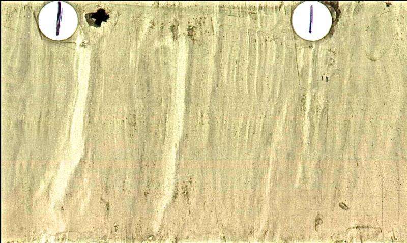
Laminations in this sediment core provide a high-fidelity record of paleoclimate change history. Credit: RICK
Global climate change isn’t new — the phenomenon has been around for millions of years. But now, a core from the ocean floor in the Santa Barbara Basin provides a remarkable ultra-high-resolution record of Earth’s paleoclimate history during a brief, dynamic time hundreds of thousands of years ago.
New research from UC Santa Barbara geologist James Kennett and colleagues examines a shift from a glacial to an interglacial climate that began about 630,000 years ago. Their research demonstrates that, although this transition developed over seven centuries, the initial shift required only 50 years. Called a deglacial episode because of its association with the melting of large Northern Hemisphere ice sheets, this interval illustrates the extreme sensitivity to change of Earth’s climate system. The findings appear in the journal Paleoceanography.
“One of the most astonishing things about our results is the abruptness of the warming in sea surface temperatures,” explained co-author Kennett, a professor emeritus in UCSB’s Department of Earth Science. “Of the 45 degree Fahrenheit total, a shift of about 40 degrees occurred almost immediately right at the beginning.”
For more than a million years, Earth’s climate has oscillated from glacial (ice age) to interglacial (warm) — the latter representing modern conditions. According to Kennett, the Santa Barbara Basin holds the most pristine marine record of these fluctuations, thanks in large part to the area’s unique location along the California margin. The basin is the confluence of the cool California current from the subpolar region and the warm countercurrent from the tropics.
“The record is incredibly high fidelity, because unlike other places where the amount of sedimentation varies as a function of climate change, here it is remarkably constant,” said co-author Craig Nicholson, a research geophysicist at UCSB’s Marine Science Institute and an adjunct professor of earth science. “That’s because it’s largely controlled by tectonics, the uplift of the mountains to the north and the islands to the south, rather than by climate change.”
Finding Climatic ‘Windows’
Because the scientists were unable to drill deeper than 200 meters into the ocean floor, they turned to tectonics to piece together a semi-continuous record of paleoclimate history. They were able to use the active tectonics to find climatic “windows” going back 700,000 years.
“With this particular core, we hit it rich,” Kennett said. “We opened a really clear window to view one of these glacial-to-interglacial transitions, providing a unique opportunity to determine just how fast the climate operated. We discovered that the changes were much faster than we ever thought possible, especially for these large shifts between a full ice age and a full interglacial. These are big events.”
Of additional interest was the discovery of a volcanic ash layer in the core. “Volcanic eruptions can produce widely distributed ash layers, each with a distinct geochemical fingerprint,” Kennett said. “Our tests showed that this particular ash was ejected from the Yellowstone volcanic caldera in Wyoming, which has exactly the same fingerprint. This huge caldera formed about 630,000 years ago, with most of the enormous volume of ash blown to the east. However, this eruption was so explosive that the ash reached the Santa Barbara Basin, forming a layer one to two inches thick. The discovery of this ash helped with dating the core.”
Kennett noted that this remarkable record of paleoclimate changes also raises an important question: What process can possibly push Earth’s climate so fast from a glacial to an interglacial state? The researchers may have discovered the answer based on the core’s geochemical record: The warming associated with the major climatic shift was accompanied by simultaneous releases of methane — a potent greenhouse gas.
“This particular episode of climate change is closely associated with instability that caused the release of methane from gas hydrates at the ocean floor,” Kennett said. “These frozen forms of methane melt when temperatures rise or pressure decreases. Changes in sea level affect the stability of gas hydrates and water temperature even more so.
“The clear synchronism of this rapid warming and the onset of the destabilization of gas hydrates is important,” Kennett concluded. “It suggests that methane hydrate instability and the warming are somehow linked, which is an interesting and potentially important observation. The beauty of these paleoclimate records from the Santa Barbara Basin is that you can actually determine these relationships at high fidelity.”
Modern Global Warming Worries
Kennett said that one of the current worries about modern global warming is that the increase in ocean temperatures will destabilize methane hydrates located at relatively shallow depths on the ocean margin, in turn causing positive feedbacks that reinforce the global warming. In fact, this appears already to be occurring in the ocean.
Recent research by others indicates that methane hydrates off the coast of Washington, Oregon and British Columbia are destabilizing in response to a small increase in bottom water temperatures (only 0.3 degrees Celsius) during the past 44 years. This is producing methane gas plumes that billow upward from the ocean floor. Additional ocean margin areas are exhibiting similar responses to warming, which are documented in other scientific work.
Kennett concluded that such investigations of past climate changes not only inform the world about how climate may change in the future but also illuminate the processes involved.
Reference:
Walter E. Dean, James P. Kennett, Richard J. Behl, Craig Nicholson, Christopher C. Sorlien. Abrupt termination of Marine Isotope Stage 16 (Termination VII) at 631.5 ka in Santa Barbara Basin, California. Paleoceanography, 2015; 30 (10): 1373 DOI: 10.1002/2014PA002756
Researchers investigating the potential impact of volcanic eruptions on climate in the world’s polar regions have concluded that they could have a destabilising effect on ice sheets.
The Durham University team found that massive volcanic eruptions could potentially cause localised warming in Antarctica and Greenland.
The research looked at links between huge volcanic eruptions and polar temperatures during the last Ice Age.
The findings suggest that some periods of Antarctic warming between 30,000 to 80,000 years ago were triggered by volcanic eruptions in the Northern Hemisphere that caused a shift in the world’s weather patterns.
The Northern Hemisphere cooled as volcanic particles reflected the sun’s heat, forcing warmer weather fronts south which led to warming in Antarctica, the researchers said.
Conversely, the research also suggests that Southern Hemisphere eruptions could have triggered abrupt warming in Greenland during the last Ice Age.
The findings are published in the journal Scientific Reports.
The Durham team, from the Department of Earth Sciences, said their findings showed that the potential effects of volcanic eruptions should be considered when predicting future climate change.
Previous research shows that there were several episodes of rapid and substantial Greenland warming of around 10C during the last Ice Age.
Such a rise could potentially have catastrophic consequences for the Greenland ice sheet and sea level rise if this were to happen today.
Lead author Dr James Baldini said: “Although this might not be an immediate threat, we should consider this new perspective regarding the effects that very large volcanic eruptions might have on future climate change.
“Current climatic background conditions are different now than they were during the last Ice Age as there are no large Northern Hemisphere ice sheets to amplify the effects of the original eruption.
“However, man-made greenhouse gas and sulphate emissions since the Industrial Revolution have already had an effect on weather patterns.
“We have to consider the reality that a large volcanic eruption could add to this problem in an unexpected way.
“For example, a large Northern Hemisphere eruption producing even only moderate Antarctic warming, when combined with an already unstable West Antarctic Ice Sheet, could have very serious consequences.”
The researchers examined data from previous studies looking at ice core samples and stalagmites that provide a natural record of changes in temperature and rainfall patterns over long periods of time.
They found evidence suggesting that changes in the position of weather fronts were associated with volcanic eruptions.
For example, the Northern Hemisphere Toba super-eruption about 74,000 years ago seems to have initiated substantial cooling in Greenland, warming in Antarctica, and a southward movement of the tropical rain belts.
True super-eruptions only occur once or twice every hundred thousand years, with the last known super-eruption happening in New Zealand about 26,000 years ago.
Such eruptions are 100 to 1,000 times larger than the eruption of Vesuvius which destroyed the Roman city of Pompeii.
However, somewhat smaller eruptions occur more frequently, with at least one very large eruption happening every thousand years, and these were considered in the study.
The research was funded by the European Research Council.
Dr Baldini said future research should attempt to confirm the link between Southern Hemisphere volcanism and Greenland warming by improving the dating of Southern Hemisphere eruptions, which are currently not well researched.
Video
Dr James Baldini from the Department of Earth Sciences at Durham University discusses the effect of volcanoes on climate.
Reference:
James U.L. Baldini, Richard J. Brown, Jim N. McElwaine. Was millennial scale climate change during the Last Glacial triggered by explosive volcanism? Scientific Reports, 2015; 5: 17442 DOI: 10.1038/srep17442
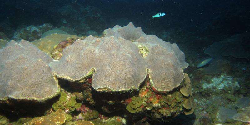
Sediment was collected between platy mesophotic coral colonies such as these, found at 35 meters. Credit: David Weinstein, Ph.D.
A University of Miami (UM) Rosenstiel School of Marine and Atmospheric Science-led research team analyzed the sediments of mesophotic coral reefs, deep reef communities living 30-150 meters below sea level, to understand how habitat diversity at these deeper depths may be recorded in the sedimentary record. The findings showed that sediments provide an important record of the bottom dwelling organisms that formed the architecture of coral reef ecosystems and support their high biodiversity today.
Coral reefs support more than 25 percent of ocean organisms, making them one of the most bio-diverse ecosystems on the planet. Studying how biodiversity evolved on deeper, mesophotic reefs can help scientists interpret the origins of their economically important shallow-reef counterparts.
“Understanding how these important marine ecosystems that we rely on for food and medicines evolved in the past gives us new insight into how to protect them in the future,” said UM Rosenstiel School alumnus and lead author of the study David Weinstein. “The results of this study provide the first analog to understanding how habitat biodiversity in these systems has evolved since the first reef-building ancient ancestors of modern corals.”
The research team collected sediments from four deep reef environments between 30-50 meters south of St. Thomas, U.S.Virgin Islands, and from two shallower water reef sites. The sediment samples were then analyzed to identify the biological, physical, and geochemical composition of the grains from the different sites. The team also examined the wave processes at the reef to show that the sedimentary deposits were primarily derived internally, with biological processes largely controlling sediment deposition.
By analyzing the sediments, scientists can predict how much coral and algae were present on mesophotic reef environment, this new information has important implications from interpreting ancient reef environments found in fossils, where the abundance of diverse habitat forming species cannot be analyzed visually.
“The mesophotic reefs of the Virgin Islands are especially vibrant and may contribute to the recovery of shallow reef systems after disturbance,” said Tyler Smith, associate research professor at the University of the Virgin Islands and coauthor of the study. “Understanding ways that we can detect these systems in the sedimentary record will show us where these systems were in the past and if they also contributed to ancient reef recovery after major coral upheavals in the Caribbean.”
Current research suggests that ancient coral reefs began as deep, dark communities that evolved into highly diverse systems by establishing communities in shallower water environments with more light.
Mesophotic reef coral ecosystems are thought to be extremely important for reef resiliency. Another important finding from the study was that waves do not transport harmful land-based sediment to mesophotic reefs on low-angel shelves like those in the USVI. In a different study published in July 2015, UM and UVI researchers discovered a threatened coral species that lives on mesophotic reefs off the U.S. Virgin Islands is more fertile than its shallow-water counterparts.
The study provides the initial steps necessary to investigate the origins of coral reef biodiversity from deeper reef origins.
“These findings opens the door for studying the geologic history of how these deep reefs evolved and responded to past environmental change,” said James Klaus, UM associate professor of geology and coauthor of the study. “Over geologic time-scales, mesophotic environments may have played an important role in the long-term sustainability of coral reefs.”
The study, titled “Habitat heterogeneity reflected in mesophotic reef sediments” was published in the Nov. 2015 issue of the journal Sedimentology Geology.
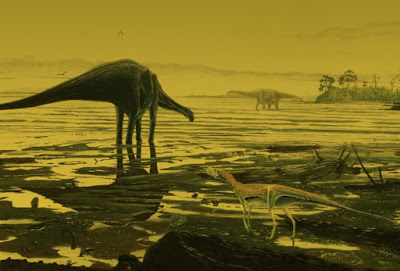
This is an artist’s impression of sauropod dinosaurs on the Isle of Skye. Credit: Jon Hoad
A newly discovered collection of rare dinosaur tracks is helping scientists shed light on some of the biggest animals ever to live on land.
Hundreds of footprints and handprints made by plant-eating sauropods around 170 million years ago have been found on the Isle of Skye in Scotland.
The discovery — which is the biggest dinosaur site yet found in Scotland — helps fill an important gap in the evolution the huge, long-necked animals, which were the biggest of the dinosaurs.
Scientists at the University of Edinburgh identified the tracks in layers of rock, which would have been at the bottom of a shallow, salt water lagoon when the prints were made.
By analysing the structure of the footprints, the team found that the dinosaurs were early, distant relatives of more well-known species, such as Brontosaurus and Diplodocus. The Skye dinosaurs likely grew to at least 15 metres in length and weighed more than 10 tonnes.
The footprints — the largest of which is 70 cm in diameter — are the first sauropod tracks to be found in Scotland. Until now, the only evidence that sauropods lived in Scotland came from a small number of bone and teeth fragments.
Fossils from the Middle Jurassic Period are extremely rare, and the Isle of Skye is one of the few places in the world where they can be found.
The discovery is helping scientists to reimagine the habitats and lifestyles of the world’s biggest dinosaurs. Together with similar tracks found recently in other parts of the world, the Skye trackways reveal that sauropods spent lots of time in coastal areas and shallow water. It was previously thought that large dinosaurs were purely land-dwellers.
A University of Edinburgh-led team found the trails during fieldwork in collaboration with Skye’s Staffin Museum and other Scottish institutions.
The study, published in Scottish Journal of Geology, was supported by the University of Edinburgh and the Royal Zoological Society of Scotland.
Dr Steve Brusatte, of the University of Edinburgh’s School of GeoSciences, who led the study, said: “The new tracksite from Skye is one of the most remarkable dinosaur discoveries ever made in Scotland. There are so many tracks crossing each other that it looks like a dinosaur disco preserved in stone. By following the tracks you can walk with these dinosaurs as they waded through a lagoon 170 million years ago, when Scotland was so much warmer than today.”
Dr Tom Challands of the School of GeoSciences, who took part in the discovery and research, said: “This find clearly establishes the Isle of Skye as an area of major importance for research into the Mid-Jurassic period. It is exhilarating to make such a discovery and being able to study it in detail, but the best thing is this is only the tip of the iceberg. I’m certain Skye will keep yielding great sites and specimens for years to come.”
Reference:
Stephen L. Brusatte, Thomas J. Challands, Dugald A. Ross, and Mark Wilkinson. Sauropod dinosaur trackways in a Middle Jurassic lagoon on the Isle of Skye, Scotland. Scottish Journal of Geology, December 1, 2015 DOI: 10.1144/sjg2015-005
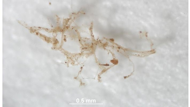
Blood vessels from deminineralized bone of Brachylophosaurus canadensis are shown. Credit: M. Schweitzer, NC State University
Researchers from North Carolina State University have confirmed that blood vessel-like structures found in an 80 million-year-old hadrosaur fossil are original to the animal, and not biofilm or other contaminants. Their findings add to the growing body of evidence that structures like blood vessels and cells can persist over millions of years, and the data not only confirm earlier reports of protein sequences in dinosaurs, they represent a significant advance in methodology.
Molecular paleontologist Tim Cleland, currently a postdoctoral researcher at the University of Texas at Austin, began the work while a graduate student at NC State. He demineralized a piece of leg bone from a Brachylophosaurus canadensis, a 30-foot-long hadrosaur that roamed what is now Montana around 80 million years ago. Cleland analyzed the demineralized bone with high resolution mass spectroscopy and found several distinct proteins from the cellular components of the blood vessels. One of these proteins, myosin, is found in the smooth muscles associated with the walls of blood vessels.
The researchers confirmed their results by performing the same process with bones from modern archosaurs, such as chicken and ostrich, which are living relatives of the dinosaurs. In both the modern and ancient samples, peptide sequences matched those found in blood vessels. Their methodology also allowed the researchers to validate previously reported sequences and recover additional sequences because only the vessels were extracted, which increased the observance of cellular proteins.
“This study is the first direct analysis of blood vessels from an extinct organism, and provides us with an opportunity to understand what kinds of proteins and tissues can persist and how they change during fossilization,” Cleland says. “This will provide new avenues for pursuing questions regarding the evolutionary relationships of extinct organisms, and will identify significant protein modifications and when they might have arisen in these lineages.”
Elena Schroeter, a postdoctoral researcher at NC State, is a co-author who worked on the analysis of the mass spectrometry data. “Paleoproteomics is a challenging pursuit. It requires us to think about how to support our conclusions from different angles,” says Schroeter. “This project is significant because it shows the power of using multiple experimental methods–as well as multiple ways to analyze the results of those methods–to address a scientific question.”
“Part of the value of this research is that it gives us insight into how proteins can modify and change over 80 million years,” says Mary Schweitzer, a molecular paleontologist at NC State and co-author of the paper describing the research. “It tells us not only about how tissues preserve over time, but gives us the possibility of looking at how these animals adapted to their environment while they were alive.”
Reference:
Timothy P. Cleland, Elena R. Schroeter, Leonid Zamdborg, Wenxia Zheng, Ji Eun Lee, John C. Tran, Marshall Bern, Michael B. Duncan, Valerie S. Lebleu, Dorothy R. Ahlf, Paul M. Thomas, Raghu Kalluri, Neil L. Kelleher, Mary H. Schweitzer. Mass Spectrometry and Antibody-Based Characterization of Blood Vessels fromBrachylophosaurus canadensis. Journal of Proteome Research, 2015; DOI: 10.1021/acs.jproteome.5b00675
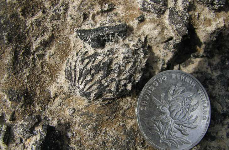
Fossilized peach pits discovered in China dating back more than 2.5 million years are identical to pits found in modern varieties of the fruit. The discovery indicates peaches evolved through natural selection, long before humans arrived and domesticated the fruit. Credit: Tao Su / Xishuangbanna Tropical Garden
The sweet, juicy peaches we love today might have been a popular snack long before modern humans arrived on the scene.
Scientists have found eight well-preserved fossilized peach endocarps, or pits, in southwest China dating back more than two and a half million years. Despite their age, the fossils appear nearly identical to modern peach pits.
The findings, reported last week in Scientific Reports, suggest that peaches evolved through natural selection well before humans domesticated the fruit. It’s the first discovery of fossilized peaches, and it sheds new light on the evolutionary history of the fruit, which has not been well understood.
“The peach is an important part of human history, and it’s important to understand how it became what it is today,” said Peter Wilf, a professor of paleobotany at Penn State and co-author of the article. “If we know the origins of our resources we can make better use of them.”
Tao Su, lead author on the paper and associate professor at Xishuangbanna Tropical Garden, discovered the fossils near his home in Kunming in southwest China when some road construction exposed a rock outcrop from the late Pliocene.
“We found these peach endocarp fossils just exposed in the strata,” Su said. “It’s really a fantastic finding.”
Su said the discovery provides important new evidence for the origins and evolution of the modern fruit. Peaches are widely thought to have originated in China, but the oldest evidence had been archeological records dating back roughly 8,000 years. No wild population has ever been found, and its long trade history makes tracing its beginnings difficult.
Animals, perhaps even primates and, eventually, early hominids, snacked on and dispersed the sweet, wild fruit and played a key role in its evolution. Only much later, after modern humans arrived, was the peach domesticated and bred. Humans have created new varieties and larger sizes ever since and spread the fruit across what is now China, and far beyond.
“Is the peach we see today something that resulted from artificial breeding under agriculture since prehistory, or did it evolve under natural selection? The answer is really both,” said Wilf, an associate in Penn State’s Earth and Environmental Systems Institute.
The researchers say the discovery supports China being the home of the peach. The fruit remains culturally significant in the country, where it carries multiple meanings — from immortality in Taoist mythology to good fortune and beauty, Su said.
“The peach was a witness to the human colonization of China,” Wilf said. “It was there before humans, and through history we adapted to it and it to us.”
Su brought the fossils to Penn State and analyzed them while working there as a visiting scholar and collaborating with Wilf. Several tests confirmed that the fossils are indeed more than 2.5 million years old and not from recent contamination. In addition to their having been found in the Pliocene rocks along with many other plant fossils, the seeds inside the pits are replaced by iron, and the walls of the pits are recrystallized. A modern peach pit would have a recent radiocarbon date, but radiocarbon analysis of the fossil peaches showed them to be older than the limit of radiocarbon dating, which is about 50,000 years.
Researchers compared the correlation between modern peach and pit size, and used that to estimate the size of the fruit during the late Pliocene as approximately 5 cm in diameter.
“If you imagine the smallest commercial peach today, that’s what these would look like, ” Wilf said. “It’s something that would have had a fleshy, edible fruit around it. It must have been delicious.”
Reference:
Tao Su, Peter Wilf, Yongjiang Huang, Shitao Zhang, Zhekun Zhou. Peaches Preceded Humans: Fossil Evidence from SW China. Scientific Reports, 2015; 5: 16794 DOI: 10.1038/srep16794
Note: The above post is reprinted from materials provided by Penn State. The original item was written by Matthew Carroll.
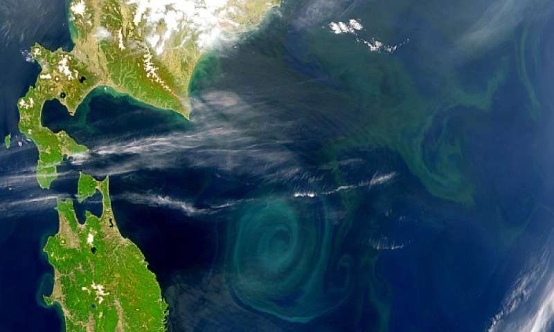
A bacterial bloom. Credit: SeaWiFS Project, NASA/Goddard Space Flight Center, and ORBIMAGE
The catalyst that allowed the evolution of complex life in Earth’s oceans has been identified by a University of Bristol researcher. Up to 800 million years ago, the Earth’s oceans were deprived of oxygen. It was only when microorganisms called phytoplankton, capable of performing photosynthesis, colonised the oceans – covering two thirds of our planet – that production of oxygen at a massive scale was made possible.
This major oxygenation event, driven by billions of tiny organisms in the ocean, set the stage for a fundamental transformation of our planet – the evolution of complex life as we know it today.
Our oceans became fully oxygenated at around 800 to 600 million years ago, when atmospheric oxygen reached modern concentrations. Crucially, this allowed for the evolution of animals and the beginning of our modern Earth System. It has long been known that cyanobacteria were the first microorganisms capable of producing oxygen. They did this through photosynthesis – a process that transforms energy from the sun into sugars and oxygen using carbon dioxide and water. Scientists have been trying to work out why it took so long for the Earth’s atmosphere to reach modern concentrations of oxygen, when photosynthesis had already evolved by around 2,700 million years ago.
Patricia Sánchez-Baracaldo, Royal Society Research Fellow, from the School of Geographical Sciences at the University of Bristol, used genomic data to trace back the origin of these crucial and transformative marine planktonic cyanobacteria.
Her research, published in Scientific Reports, revealed that various different types of marine planktonic forms evolved relatively late – between 800 to 500 million years ago, arising from freshwater and/or marine benthic ancestors.
Early on, these cyanobacteria dominated only terrestrial and coastal environments, and with relatively low impact on the Earth’s nutrient cycles. It was only when they properly colonised the oceans that the major, planet-altering event occurred.
Dr Sánchez-Baracaldo said: ‘The results of this large-scale phylogenomic study imply that, early on, terrestrial cyanobacteria capable of building microbial mats dominated the ecology of the Early Earth’
‘Rather surprisingly, marine planktonic cyanobacteria are relatively young, only evolving just prior to the origin of complex life – animals. By producing oxygen in vast quantities, these cyanobacteria enabled the development of complex life in our oceans. These biological events are linked – they help explain why it took so long for complex life to evolve on our planet. Cyanobacteria needed to colonise the oceans first’,
‘This study shows that several factors contributed to the delay of the oxygenation of the Earth’s oceans. Firstly, cyanobacteria evolved in freshwater habitats and not in marine habitats as previously thought, and, second, marine productivity had a huge boost when cyanobacteria were finally able to colonise marine habitats; this allowed for the production of oxygen and carbon burial at unprecedented levels.’
‘The genomic revolution has hugely improved our understanding of the tree of life of cyanobacteria. Without cyanobacteria, complex life on our planet as we know it simply would not have happened.’ said Dr Sánchez-Baracaldo.
Falling oxygen levels caused by global warming could be a greater threat to the survival of life on planet Earth than flooding, according to researchers from the University of Leicester.
A study led by Sergei Petrovskii, Professor in Applied Mathematics from the University of Leicester’s Department of Mathematics, has shown that an increase in the water temperature of the world’s oceans of around six degrees Celsius — which some scientists predict could occur as soon as 2100 — could stop oxygen production by phytoplankton by disrupting the process of photosynthesis.
Professor Petrovskii explained: “Global warming has been a focus of attention of science and politics for about two decades now. A lot has been said about its expected disastrous consequences; perhaps the most notorious is the global flooding that may result from melting of Antarctic ice if the warming exceeds a few degrees compared to the pre-industrial level. However, it now appears that this is probably not the biggest danger that the warming can cause to the humanity.
“About two-thirds of the planet’s total atmospheric oxygen is produced by ocean phytoplankton — and therefore cessation would result in the depletion of atmospheric oxygen on a global scale. This would likely result in the mass mortality of animals and humans.”
The team developed a new model of oxygen production in the ocean that takes into account basic interactions in the plankton community, such as oxygen production in photosynthesis, oxygen consumption because of plankton breathing and zooplankton feeding on phytoplankton.
While mainstream research often focuses on the CO2 cycle, as carbon dioxide is the agent mainly responsible for global warming, few researchers have explored the effects of global warming on oxygen production.
The 2015 United Nations Climate Change Conference will be held in Le Bourget, Paris, from November 30 to December 11. It will be the 21st yearly session of the Conference of the Parties to the 1992 United Nations Framework Convention on Climate Change (UNFCCC) and the 11th session of the Meeting of the Parties to the 1997 Kyoto Protocol. The conference objective is to achieve a legally binding and universal agreement on climate, from all the nations of the world.
Reference:
Yadigar Sekerci, Sergei Petrovskii. Mathematical Modelling of Plankton–Oxygen Dynamics Under the Climate Change. Bulletin of Mathematical Biology, 2015; DOI: 10.1007/s11538-015-0126-0
The leptoceratopsids have a beak-shaped jaw suggesting they had a different diet to their western relatives.
A rare fossil from eastern North America of a dog-sized horned dinosaur has been identified by Dr Nick Longrich. The fossil provides evidence of an east-west divide in North American dinosaur evolution.
During the Late Cretaceous period, 66-100 million years ago, the land mass that is now North America was split in two continents by a shallow sea, the Western Interior Seaway, which ran from the Gulf of Mexico to the Arctic Ocean. Dinosaurs living in the western continent, called Laramidia, were similar to those found in Asia.
However, few fossils of animals from the eastern ‘lost continent’ of Appalachia have been found because these areas being densely vegetated, making it difficult to discover and excavate fossils.
Dr Longrich, from the Milner Centre for Evolution based in our Department of Biology & Biochemistry, studied one of these rare fossils, a fragment of a jaw bone kept in the Peabody Museum at Yale University. It turned out to be a member of the horned dinosaurs – the Ceratopsia.
His study, published in the journal Cretaceous Research, highlights it as the first fossil from a ceratopsian dinosaur identified from this period of eastern North America.
Plant-eating horned dinosaur
Ceratopsia is a group of plant-eating horned dinosaurs that lived in the Cretaceous period. The fossil in question comes from a smaller cousin of the better known Triceratops, the leptoceratopsids. It was about the size of a large dog.
The specimen studied by Longrich was too incomplete to identify the exact species accurately, but showed a strange twist to the jaw, causing the teeth to curve downward and outwards in a beak shape.
The jaw was also more slender than that of Ceratopsia found in western North America, suggesting that these dinosaurs had a different diet to their western relatives, and had evolved along a distinct evolutionary path.
Dr Nick Longrich explained: “Just as many animals and plants found in Australia today are quite different to those found in other parts of the world, it seems that animals in the eastern part of North America in the Late Cretaceous period evolved in a completely different way to those found in the western part of what is now North America due to a long period of isolation.
“This adds to the theory that these two land masses were separated by a stretch of water, stopping animals from moving between them, causing the animals in Appalachia to evolve in a completely different direction, resulting in some pretty weird looking dinosaurs.
“Studying fossils from this period, when the sea levels were very high and the landmasses across the Earth were very fragmented, is like looking at several independent experiments in dinosaur evolution.
“At the time, many land masses – eastern North America, Europe, Africa, South America, India, and Australia – were isolated by water.
“Each one of these island continents would have evolved its own unique dinosaurs – so there are probably many more species out there to find.”
Reference:
Nicholas R. Longrich. A ceratopsian dinosaur from the Late Cretaceous of eastern North America, and implications for dinosaur biogeography, Cretaceous Research (2016). DOI: 10.1016/j.cretres.2015.08.004