Home Blog Page 12

A river is pushing up Mount Everest’s peak

Himalaya
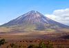
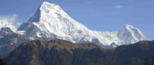
Mountains Annapurna South and Hiunchuli from near Ghandruk in the Himalaya of central Nepal. Credit: David Whipp

Mount Everest is about 15 to 50 metres taller than it would otherwise be because of uplift caused by a nearby eroding river gorge, and continues to grow because of it, finds a new study by UCL researchers.

The study, published in Nature Geoscience, found that erosion from a river network about 75 kilometres from Mount Everest is carving away a substantial gorge. The loss of this landmass is causing the mountain to spring upwards by as much as 2 millimetres a year and has already increased its height by between 15 and 50 metres over the past 89,000 years.

At 8,849 metres high, Mount Everest, also known as Chomolungma in Tibetan or Sagarmāthā in Nepali, is the tallest mountain on Earth, and rises about 250 metres above the next tallest peak in the Himalayas. Everest is considered anomalously high for the mountain range, as the next three tallest peaks — K2, Kangchenjunga and Lhotse — all only differ by about 120 metres from each other.

A significant portion of this anomaly can be explained by an uplifting force caused by pressure from below Earth’s crust after a nearby river eroded away a sizeable amount of rocks and soils. It’s an effect called isostatic rebound, where a section of the Earth’s crust that loses mass flexes and “floats” upwards because the intense pressure of the liquid mantle below is greater than the downward force of gravity after the loss of mass. It’s a gradual process, usually only a few millimetres a year, but over geological timeframes can make a significant difference to the Earth’s surface.

The researchers found that because of this process Mount Everest grew by about 15 to 50 metres over the last 89,000 years, since the nearby Arun river merged with the adjacent Kosi river network.

Co-author, PhD student Adam Smith (UCL Earth Sciences) said: “Mount Everest is a remarkable mountain of myth and legend and it’s still growing. Our research shows that as the nearby river system cuts deeper, the loss of material is causing the mountain to spring further upwards.”

Today, the Arun river runs to the east of Mount Everest and merges downstream with the larger Kosi river system. Over millennia, the Arun has carved out a substantial gorge along its banks, washing away billions of tonnes of earth and sediment.

Co-author Dr Jin-Gen Dai of the China University of Geosciences, said: “An interesting river system exists in the Everest region. The upstream Arun river flows east at high altitude with a flat valley. It then abruptly turns south as the Kosi river, dropping in elevation and becoming steeper. This unique topography, indicative of an unsteady state, likely relates to Everest’s extreme height.”

The uplift is not limited to Mount Everest, and affects neighbouring peaks including Lhotse and Makalu, the world’s fourth and fifth highest peaks respectively. The isostatic rebound boosts the heights of these peaks by a similar amount as it does Everest, though Makalu, located closest to the Arun river, would experience a slightly higher rate of uplift.

Co-author Dr Matthew Fox (UCL Earth Sciences) said: “Mount Everest and its neighbouring peaks are growing because the isostatic rebound is raising them up faster than erosion is wearing them down. We can see them growing by about two millimetres a year using GPS instruments and now we have a better understanding of what’s driving it.”

By looking at the erosion rates of the Arun, the Kosi and other rivers in the region, the researchers were able to determine that about 89,000 years ago the Arun river joined and merged with the Kosi river network, a process called drainage piracy. In doing so, more water was funnelled through the Kosi river, increasing its erosive power and taking more of the landscape’s soils and sediments with it. With more of the land washed away, it triggered an increased rate of uplift, pushing the mountains’ peaks higher and higher.

Lead author Dr Xu Han of China University of Geosciences, who carried out the work while on a China Scholarship Council research visit to UCL, said: “The changing height of Mount Everest really highlights the dynamic nature of the Earth’s surface. The interaction between the erosion of the Arun river and the upward pressure of the Earth’s mantle gives Mount Everest a boost, pushing it up higher than it would otherwise be.”

Reference:
Xu Han, Jin-Gen Dai, Adam G. G. Smith, Shi-Ying Xu, Bo-Rong Liu, Cheng-Shan Wang, Matthew Fox. Recent uplift of Chomolungma enhanced by river drainage piracy. Nature Geoscience, 2024; DOI: 10.1038/s41561-024-01535-w

Note: The above post is reprinted from materials provided by University College London.
Ancient sunken seafloor reveals earth’s deep secrets

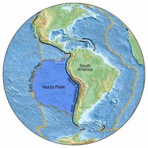
A map of the East Pacific Rise region where the discovery of an ancient seafloor was made. Credit: Jingchuan Wang.

University of Maryland scientists uncovered evidence of an ancient seafloor that sank deep into Earth during the age of dinosaurs, challenging existing theories about Earth’s interior structure. Located in the East Pacific Rise (a tectonic plate boundary on the floor of the southeastern Pacific Ocean), this previously unstudied patch of seafloor sheds new light on the inner workings of our planet and how its surface has changed over millions of years. The team’s findings were published in the journal Science Advances on September 27, 2024.

Led by geology postdoctoral researcher Jingchuan Wang, the team used innovative seismic imaging techniques to peer deep into Earth’s mantle, the layer between our planet’s crust and core. They found an unusually thick area in the mantle transition zone, a region located between about 410 and 660 kilometers below the Earth’s surface. The zone separates the upper and lower mantles, expanding or contracting based on temperature. The team believes that the newly discovered seafloor may also explain the anomalous structure of the Pacific Large Low Shear Velocity Province (LLSVP) — a massive region in Earth’s lower mantle — as the LLSVP appears to be split by the slab.

“This thickened area is like a fossilized fingerprint of an ancient piece of seafloor that subducted into the Earth approximately 250 million years ago,” Wang said. “It’s giving us a glimpse into Earth’s past that we’ve never had before.”

Subduction occurs when one tectonic plate slides beneath another, recycling surface material back into Earth’s mantle. The process often leaves visible evidence of movement, including volcanoes, earthquakes and deep marine trenches. While geologists typically study subduction by examining rock samples and sediments found on Earth’s surface, Wang worked with Geology Professor Vedran Lekic and Associate Professor Nicholas Schmerr to use seismic waves to probe through the ocean floor. By examining how seismic waves traveled through different layers of Earth, the scientists were able to create detailed mappings of the structures hiding deep within the mantle.

“You can think of seismic imaging as something similar to a CT scan. It’s basically allowed us to have a cross-sectional view of our planet’s insides,” Wang said. “Usually, oceanic slabs of material are consumed by the Earth completely, leaving no discernible traces on the surface. But seeing the ancient subduction slab through this perspective gave us new insights into the relationship between very deep Earth structures and surface geology, which were not obvious before.”

What the team found surprised them — material was moving through Earth’s interior much more slowly than previously thought. Wang believes that the unusual thickness of the area the team discovered suggests the presence of colder material in this part of the mantle transition zone, hinting that some oceanic slabs get stuck halfway down as they sink through the mantle.

“We found that in this region, the material was sinking at about half the speed we expected, which suggests that the mantle transition zone can act like a barrier and slow down the movement of material through the Earth,” Wang explained. “Our discovery opens up new questions about how the deep Earth influences what we see on the surface across vast distances and timescales.”

Looking ahead, the team plans to extend their research into other areas of the Pacific Ocean and beyond. Wang hopes to create a more comprehensive map of ancient subduction and upwelling (the geological process that occurs when subducted material heats up and rises to the surface again) zones, as well as their effects on both deep and surface Earth structures. With the seismic data acquired from this research, Wang and other scientists are improving their models of how tectonic plates have moved throughout Earth’s history.

“This is just the beginning,” Wang said. “We believe that there are many more ancient structures waiting to be discovered in Earth’s deep interior. Each one has the potential to reveal many new insights about our planet’s complex past — and even lead to a better understanding of other planets beyond ours.”

Reference:
Jingchuan Wang, Vedran Lekić, Nicholas C. Schmerr, Yu J. Gu, Yi Guo, Rongzhi Lin. Mesozoic intraoceanic subduction shaped the lower mantle beneath the East Pacific Rise. Science Advances, 2024; 10 (39) DOI: 10.1126/sciadv.ado1219

Note: The above post is reprinted from materials provided by University of Maryland.

Reconstructing the evolutionary history of the grape family

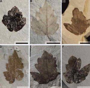
Nekemias mucronata fossil lateral leaflets from the collection of the Natural Science Museum of Barcelona.

Until now, it was believed that plants of the grape family arrived at the European continent less than 23 million years ago. A study on fossil plants draws a new scenario on the dispersal of the ancestors of grape plants and reveals that these species were already on the territory of Europe some 41 million years ago. The paper describes a new fossil species of the same family, Nekemias mucronata, which allows us to better understand the evolutionary history of this plant group, which inhabited Europe between 40 and 23 million years ago.

This study, published in the Journal of Systematics and Evolution (JSE), is led by researcher Aixa Tosal, from the Faculty of Earth Sciences and the Biodiversity Research Institute (IRBio) of the University of Barcelona. The article is also signed by Alba Vicente, from the Biodiversity Research Institute (IRBio) and the Catalan Institute of Palaeontology Miquel Crusafont (ICP), and Thomas Denk, from the Swedish Museum of Natural History (Stockholm).

A new ancestor of the grape family

The grape family (Vitaceae) is made up of some 950 species, and is divided into five tribes (in botany, this is an intermediate taxonomic classification between the family and the genus). One of these tribes is the Viteae, made up of 200 species, including the grape vine plant (Vitis vinifera), which is of great global economic interest. The new paper published in the JSE focuses on studying the tribe Ampelopsideae, made up of 47 species.

“Our study changes the paradigms accepted until now and shows that the Ampelopsis and Nekemias lineages of the Ampelopsideae tribe were already present in Europe and Central Asia during the middle Eocene (between 47 and 37 million years ago). This indicates that this dispersal was approximately 20 million years earlier than previously estimated,” says Aixa Tosal, first author of the study and member of the UB’s Department of Earth and Ocean Dynamics.

“In particular, we show that a lineage now restricted to North America already existed in Europe and Central Asia, thanks to the discovery of the fossil species Nekemias mucronata, which is very similar to the present-day North American Nekemias arborea. Nekemias mucronata cohabited with Ampelopsis hibschii, the closest relative of today’s Ampelopsis orientalis,” explains Tosal. In contrast, the latter has had a different dispersal from N. mucronata, as this lineage is now endemic to the eastern Mediterranean. “This study helps us to better understand the evolution of the Ampelopsideae tribe during the second dispersal pulse, especially in Europe and Central Asia, which took place during the Palaeogene,” says Tosal.

Nekemias mucronata lived from the late Eocene to the late Oligocene (37-23 million years ago). It seems that it was able to grow in a broad range of climates, from regions with low winter temperatures (-4.6 °C in cold periods) — such as those found in Kazakhstan during the Oligocene (33-23) million years ago — to regions with warm mean annual temperatures — such as those of the Oligocene in the Iberian Peninsula — or even in climates with intermediate temperatures such as those recorded in the centre of the European continent.

“N. mucronata was also not overly demanding in terms of rainfall. It could grow in areas with abundant rainfall and low rainfall seasonality; for example, in Central Europe during the Oligocene, or the Iberian Peninsula or Greece during the same time,” says ICP researcher Alba Vicente. “This fossil species had a compound leaf, a peculiarity shared with some species of the vine family. Although it is difficult to confirm the number of leaflets of the compound leaf, it would have consisted of at least three. We have been able to recognize common patterns between the apical and lateral leaflets, which allows us to distinguish them from other fossil species of the vine family in Eurasia,” he adds. “What makes Nekemias mucronata unique is the presence of a mucro at the tip of the leaflet teeth, which gives the species its name. The straight shape of the base of the apical leaflet is also quite distinctive, as all other Eurasian fossil species are buckled (with an invagination near the petiole),” says Vicente.

Dispersal of Ampelopsideae across the Atlantic bridge or the Bering Strait

To date, the oldest record of the grape family has been found in the Upper Cretaceous deposits of India (75-65 Ma). The earliest record of the plant lineage in the Americas is from the Upper Eocene, around 39.4 million years ago, and at about the same time in Europe and Central Asia the Ampelopsis and Nekemias lineages are already found.

How did these species disperse in the past? These tribes diverged between the Upper Cretaceous and the Upper Eocene and, although there are still many unknowns, it seems that they dispersed and evolved quite rapidly. According to current data, which are consistent with the molecular clock technique, “the Ampelopsideae could have followed two cluster routes or a mixture of both. The first proposed route follows the North Atlantic isthmus. That is, the family appeared in India, then moved on to central Asia and Europe during the middle Eocene (between 47 and 37 million years ago), and finally moved on to the Americas via Greenland,” says Thomas Denk. “Another possible route suggests that, once the Vitaceae family appeared in India, the Ampelopsideae tribe dispersed eastward from Asia during the middle Eocene (47-37 million years ago) and quickly moved to the Americas via the Bering Strait, and from there to Europe along the North Atlantic isthmus,” Denk says.

Although the dispersal of these two species does not seem to be linked to climate, it is possible that the increase in aridity during the Oligocene in the Iberian Peninsula and southern Europe explains the extinction (27-23 million years ago) of the last population of N. mucronata found in the Iberian Peninsula. In parallel, Ampelopsis hibschii was restricted to the Balkan area and finally became extinct about 15 million years ago.

“However, there are still many unanswered questions about the early dispersal phases (from the Late Cretaceous to the Palaeogene). For this reason, we would like to continue studying this family, and perhaps we will be able to unravel what happened during their early cluster phases, which occurred between 66 and 41 million years ago,” the team concludes.

Reference:
Aixa Tosal, Alba Vicente, Thomas Denk. Cenozoic Ampelopsis and Nekemias leaves (Vitaceae, Ampelopsideae) from Eurasia: Paleobiogeographic and paleoclimatic implications. Journal of Systematics and Evolution, 2024; DOI: 10.1111/jse.13126

Note: The above post is reprinted from materials provided by University of Barcelona.

Brazilian fossils reveal jaw-dropping discovery in mammal evolution

Riograndia and BrasilodonCredit: Jorge Blanco
Riograndia and Brasilodon
Credit: Jorge Blanco

These fossils, belonging to the mammal-precursor species Brasilodon quadrangularis and Riograndia guaibensis, offer critical insights into the development of the mammalian jaw and middle ear, revealing evolutionary experiments that occurred millions of years earlier than previously thought.

Mammals stand out among vertebrates for their distinct jaw structure and the presence of three middle ear bones. This transition from earlier vertebrates, which had a single middle ear bone, has long fascinated scientists. The new study explores how mammal ancestors, known as cynodonts, evolved these features over time.

Using CT scanning, researchers were able to digitally reconstruct the jaw joint of these cynodonts for the first time. The researchers uncovered a ‘mammalian-style’ contact between the skull and the lower jaw in Riograndia guaibensis, a cynodont species that lived 17 million years before the previously oldest known example of this structure, but did not find one in Brasilodon quadrangularis, a species more closely related to mammals. This indicates that the defining mammalian jaw feature evolved multiple times in different groups of cynodonts, earlier than expected.

These findings suggest that mammalian ancestors experimented with different jaw functions, leading to the evolution of ‘mammalian’ traits independently in various lineages. The early evolution of mammals, it turns out, was far more complex and varied than previously understood.

Lead author James Rawson based in Bristol’s School of Earth Sciences explained: “The acquisition of the mammalian jaw contact was a key moment in mammal evolution.

“What these new Brazilian fossils have shown is that different cynodont groups were experimenting with various jaw joint types, and that some features once considered uniquely mammalian evolved numerous times in other lineages as well.”

This discovery has broad implications for the understanding of the early stages of mammal evolution, illustrating that features such as the mammalian jaw joint and middle ear bones evolved in a patchwork, or mosaic, fashion across different cynodont groups.

Dr. Agustín Martinelli, from the Museo Argentino de Ciencias Natural of Buenos Aires, stated: “Over the last years, these tiny fossil species from Brazil have brought marvellous information that enrich our knowledge about the origin and evolution of mammalian features. We are just in the beginning and our multi-national collaborations will bring more news soon.”

The research team is eager to further investigate the South American fossil record, which has proven to be a rich source of new information on mammalian evolution.

Professor Marina Soares of the Museu Nacional, Brazil, stated: “Nowhere else in the world has such a diverse array of cynodont forms, closely related to the earliest mammals.”

By integrating these findings with existing data, the scientists hope to deepen their understanding of how early jaw joints functioned and contributed to the development of the mammalian form.

James added: “The study opens new doors for paleontological research, as these fossils provide invaluable evidence of the complex and varied evolutionary experiments that ultimately gave rise to modern mammals.”

Reference:
Rawson, J.R.G., Martinelli, A.G., Gill, P.G. et al. Brazilian fossils reveal homoplasy in the oldest mammalian jaw joint. Nature, 2024 DOI: 10.1038/s41586-024-07971-3

Note: The above post is reprinted from materials provided by University of Bristol.

Unveiling ancient life: New method sheds light on early cellular and metabolic evolution

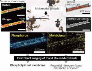
Results of the multimodal analysis conducted on microfossils mounted on ITO glass. Optical observation, electron microscopy, and secondary ion mass spectrometry were performed on the same sample. The analysis successfully detected phosphorus and molybdenum aligned with the microfossil's membrane structure for the first time. ©Tohoku University
Results of the multimodal analysis conducted on microfossils mounted on ITO glass. Optical observation, electron microscopy, and secondary ion mass spectrometry were performed on the same sample. The analysis successfully detected phosphorus and molybdenum aligned with the microfossil’s membrane structure for the first time. ©Tohoku University

Fossils don’t always come in large, dinosaur-sized packages. Microfossils refer to a type of fossil that is so small, it can only be perceived with a microscope. These microfossils can help us understand when and how early life forms developed essential features — ultimately allowing us to study the evolution of life. In order to analyze these microfossils, a pioneering method of analysis has been developed by a research team led by Akizumi Ishida from Tohoku University, in collaboration with experts from the University of Tokyo and Kochi University.

“To analyze microfossils, scientists must detect minute quantities of critical elements like phosphorus and molybdenum,” explains Ishida, “However, so far this has proven challenging.”

Their work focuses on 1.9-billion-year-old Gunflint microfossils, which are known as the “standard” of microfossil study.

The team employed a novel approach by fixing these microfossils onto a specially coated glass slide (ITO-glass), allowing for integrated observations using both optical and electron microscopy.

ITO-glass is a glass plate coated with a thin layer of indium tin oxide (ITO). This conductive coating of metal oxide is not only suitable for electron microscopy and secondary ion mass spectrometry (SIMS), but also allows for optical observation.

Due to its transparency, the internal structure of microfossils can be examined.

This method also enabled the precise detection of trace elements within the microfossils.

In other words, it was able to clearly detect the true amount contrasted against a base level of background “noise.” Phosphorus also occurs naturally in sedimentary rocks, for example, so it’s important to be able to tell the difference.

By overcoming the interference from rock-derived elements and materials used to mount the fossils, the researchers successfully identified extremely low levels of phosphorus and molybdenum by using NanoSIMS (High Spatial Resolution Secondary Ion Mass Spectrometer). This device allows for the imaging of almost all elements except noble gases with ultra-high spatial resolution of less than one micron.

Their analysis of phosphorus seen along the contours of microfossils revealed that these ancient microorganisms already had phospholipid cell membranes similar to those found in modern organisms.

Additionally, the presence of molybdenum within microfossil bodies suggested the existence of possible nitrogen-fixing metabolic enzymes, consistent with previous reports identifying these microfossils as cyanobacteria.

This innovative protocol is unique in its ability to provide consistent observations and analyses on the same sample.

It offers significant advancements in understanding how life evolved on Earth’s, providing direct evidence of cell membranes and metabolic processes in ancient microorganisms.

This technique is applicable not only to microfossils but also to early Earth’s geological samples with minimal organic material. It opens avenues for analyzing even older geological periods. Additionally, it extends to trace elements such as copper, nickel, and cobalt, which can reveal metabolic patterns. The findings are expected to set new standards in early life evolution research and ultimately contribute to answering the profound questions about when and where life originated and how it evolved on Earth.

Reference:
Kohei Sasaki, Akizumi Ishida, Takeshi Kakegawa, Naoto Takahata, Yuji Sano. Ultrahigh-resolution imaging of biogenic phosphorus and molybdenum in palaeoproterozoic gunflint microfossils. Scientific Reports, 2024; 14 (1) DOI: 10.1038/s41598-024-72191-8

Note: The above post is reprinted from materials provided by Tohoku University.

Over nearly half a billion years, Earth’s global temperature has changed drastically, driven by carbon dioxide

Earth has been warmer than today over the past 485 million years, but humans and animals cannot adapt fast enough to keep up with human-caused climate change at the rate it is happening today and in the future.Shutterstock
Earth has been warmer than today over the past 485 million years, but humans and animals cannot adapt fast enough to keep up with human-caused climate change at the rate it is happening today and in the future.
Shutterstock

Published in the journal Science, the study presents a curve of global mean surface temperature that reveals Earth’s temperature has varied more than previously thought over much of the Phanerozoic Eon a period of geologic time when life diversified, populated land and endured multiple mass extinctions. The curve also confirms Earth’s temperature is strongly correlated to the amount of carbon dioxide in the atmosphere.

The start of the Phanerozoic Eon 540 million years ago is marked by the Cambrian Explosion, a point in time when complex, hard-shelled organisms first appeared in the fossil record. Although researchers can create simulations all the way back to 540 million years ago, the temperature curve in the study focuses on the last 485 million years since there is limited geological data of temperature before then.

“It’s hard to find rocks that are that old and have temperature indicators preserved in them — even at 485 million years ago we don’t have that many. We were limited with how far back we could go,” said study co-author Jessica Tierney, a paleoclimatologist at the University of Arizona.

The researchers created the temperature curve using an approach called data assimilation. This allowed them to combine data from the geologic record and climate models to create a more cohesive understanding of ancient climates.

“This method was originally developed for weather forecasting,” said Emily Judd, lead author of the paper and a former postdoctoral researcher at the Smithsonian National Museum of Natural History and the U of A. “Instead of using it to forecast future weather, here we’re using it to hindcast ancient climates.”

Refining scientists’ understanding of how Earth’s temperature has fluctuated over time provides crucial context for understanding modern climate change.

“If you’re studying the last couple of million years, you won’t find anything that looks like what we expect in 2100 or 2500,” said Scott Wing, a co-author on the paper and a curator of paleobotany at the Smithsonian National Museum of Natural History. “You need to go back even further to periods when the Earth was really warm, because that’s the only way we’re going to get a better understanding of how the climate might change in the future.”

The new curve reveals that temperature varied more greatly during the past 485 million years than previously thought. Over the eon, the global temperature spanned 52 to 97 degrees Fahrenheit. Periods of extreme heat were most often linked to elevated levels of the greenhouse gas carbon dioxide in the atmosphere.

“This research illustrates clearly that carbon dioxide is the dominant control on global temperatures across geological time,” said Tierney. “When CO2 is low, the temperature is cold; when CO2 is high, the temperature is warm.”

The findings also reveal that the Earth’s current global temperature of 59 degrees Fahrenheit is cooler than Earth has been over much of the Phanerozoic. But greenhouse gas emissions from human-caused climate change are currently warming the planet at a much faster rate than even the fastest warming events of the Phanerozoic, the reseaerchers say. The speed of warming puts species and ecosystems around the world at risk and is causing a rapid rise in sea level. Some other episodes of rapid climate change during the Phanerozoic have sparked mass extinctions.

Rapidly moving toward a warmer climate could spell danger for humans who have mostly lived in a 10 degree Fahrenheit range for the global temperatures, compared to the 45 degree span of temperatures over the last 485 million years, the researchers say.

“Our entire species evolved to an ‘ice house’ climate, which doesn’t reflect most of geological history,” Tierney said. “We are changing the climate into a place that is really out of context for humans. The planet has been and can be warmer — but humans and animals can’t adapt that fast.”

The collaboration between Tierney and researchers at the Smithsonian began in 2018. The team wanted to provide museum visitors with a curve that charted Earth’s global temperature across the Phanerozoic, which began around 540 million years ago and continues into the present day.

The team collected more than 150,000 estimates of ancient temperature calculated from five different chemical indicators for temperature that are preserved in fossilized shells and other types of ancient organic matter. Their colleagues at the University of Bristol created more than 850 model simulations of what Earth’s climate could have looked like at different periods of the distant past based on continental position and atmospheric composition. The researchers then combined these two lines of evidence to create the most accurate curve of how Earth’s temperature has varied over the past 485 million years.

Another finding from the study pertains to climate sensitivity, a metric of how much the climate warms for the doubling of carbon dioxide.

“We found that carbon dioxide and temperature are not only really closely related, but related in the same way across 485 million years. We don’t see that the climate is more sensitive when it’s hot or cold,” Tierney said.

In addition to Judd, Tierney, Huber and Wing, Daniel Lunt and Paul Valdes of the University of Bristol and Isabel Montañez of the University of California, Davis are coauthors on the study.

The research was supported by Roland and Debra Sauermann through the Smithsonian; the Heising-Simons Foundation and the University of Arizona’s Thomas R. Brown Distinguished Chair in Integrative Science through Tierney; and the United Kingdom’s Natural Environment Research Council.

Reference:
Emily J. Judd, Jessica E. Tierney, Daniel J. Lunt, Isabel P. Montañez, Brian T. Huber, Scott L. Wing, Paul J. Valdes. A 485-million-year history of Earth’s surface temperature. Science, 2024; 385 (6715) DOI: 10.1126/science.adk3705

Note: The above post is reprinted from materials provided by University of Arizona.

Extinct volcanoes a ‘rich’ source of rare earth elements

volcano
volcano

A mysterious type of iron-rich magma entombed within extinct volcanoes is likely abundant with rare earth elements and could offer a new way to source these in-demand metals, according to new research from The Australian National University (ANU) and the University of the Chinese Academy of Sciences.

Rare earth elements are found in smartphones, flat screen TVs, magnets, and even trains and missiles.

They are also vital to the development of electric vehicles and renewable energy technologies such as wind turbines.

Dr Michael Anenburg from ANU said the iron-rich magma that solidified to form some extinct volcanoes is up to a hundred times more efficient at concentrating rare earth metals than the magmas that commonly erupt from active volcanoes.

“We have never seen an iron-rich magma erupt from an active volcano, but we know some extinct volcanoes, which are millions of years old, had this enigmatic type of eruption,” Dr Anenburg said.

“Our findings suggest that these iron-rich extinct volcanoes across the globe, such as El Laco in Chile, could be studied for the presence of rare earth elements.”

The researchers simulated volcanic eruptions in the lab by sourcing rocks similar to those from iron-rich extinct volcanoes.

They put these rocks into a pressurised furnace and heated them to extremely high temperatures to melt them and learn more about the minerals inside the rocks.

This is how they discovered the abundance of rare earth elements contained in iron-rich volcanic rocks.

With more countries investing heavily in renewable energy technologies, the demand for rare earth elements continues to skyrocket.

In fact, demand for these elements is expected to increase fivefold by 2030.

“Rare earth elements aren’t that rare. They are similar in abundance to lead and copper. But breaking down and extracting these metals from the minerals they reside in is challenging and expensive,” Dr Anenburg said.

China has the biggest deposit of rare earth elements on the planet, while Europe’s largest deposit of rare earths is in Sweden.

Australia has a world-class deposit at Mount Weld in Western Australia and others near Dubbo and Alice Springs.

According to Dr Anenburg, Australia has an opportunity to become a major player in the clean energy space by capitalising on its abundance of rare earth resources.

The research is published in Geochemical Perspectives Letters. This work was led by Shengchao Yan from the University of the Chinese Academy of Sciences.

Reference:
S.C. Yan, B. Wan, M. Anenburg, J.A. Mavrogenes. Silicate and iron phosphate melt immiscibility promotes REE enrichment. Geochemical Perspectives Letters, 2024; 32: 14 DOI: 10.7185/geochemlet.2436

Note: The above post is reprinted from materials provided by Australian National University.

New research reenvisions Earth’s mantle as a relatively uniform reservoir

"Lava" Earth's mantle
Credit: Massachusetts Institute of Technology

Lavas from hotspots — whether erupting in Hawaii, Samoa or Iceland — likely originate from a worldwide, uniform reservoir in Earth’s mantle, according to an evaluation of volcanic hotspots published today in Nature Geoscience.

The findings indicate Earth’s mantle is far more chemically homogenous than scientists previously thought — and that lavas only acquire their unique chemical “flavours” enroute to the surface.

“The discovery literally turns our view of hotspot lavas and the mantle upside down,” said Dr. Matthijs Smit, associate professor and Canada Research Chair at the University of British Columbia’s Department of Earth, Ocean and Atmospheric Sciences. “In a way, Earth’s lavas are much like humankind itself — a beautifully diverse population with a common ancestor, which developed differently wherever it went.”

Research of Earth’s mantle has been complicated by the fact that it can’t be sampled directly. Scientists instead have to engage in a bit of geoscientific detective work; they study this important part of our planet through trace-element and isotope analysis of lava that comes from the mantle and is erupted at oceanic volcanoes around the world. The vast differences in composition of these lavas, along with the assumption that the isotope composition of magma doesn’t change between its source and the surface, has led to the general view that the mantle contains distinct reservoirs of different age, located in different regions, and formed by different processes. The observations made by Dr. Smit and co-author Dr. Kooijman of the Swedish Museum of Natural History’s Department of Geosciences indicate that the reality may be quite different.

“By looking at a specific set of elements, we were able discern the chemical effects of various processes that act on magma melts on their way to the surface to discover that all hotspot lavas actually share the same starting composition,” said Dr. Smit. “The lavas only come out differently because the magmas interact with different types of rocks as they ascend.”

Earth’s mantle is a seething layer of molten and semi-molten material comprising about 84 per cent of the planet’s volume, which lies between the iron core and the surface crust. When magma derived from the mantle penetrates the crust and erupts onto the surface it is called lava.

Knowing what the mantle is made of is central to our understanding of how our planet formed and how the mantle has developed over time. It may also provide clues as to why the mantle behaves the way it does, how it drives plate tectonics, and what its role is in the global cycle of elements.

Besides shedding entirely new light on hotspot lavas in oceanic parts of the world, the analysis also revealed an exciting new link to basaltic lavas on the continents. These melts, which contain diamond-bearing kimberlites, are fundamentally different from magmas found at oceanic hotspots. They nevertheless prove to have the same magma “ancestor.”

“The discovery is a game-changer when it comes to models for Earth’s chemical evolution and how we look at global element cycles,” said Dr. Smit. “Not only is the mantle much more homogeneous than previously thought, it likely also no longer contains “primordial reservoirs” — entities that were once needed to explain the data, but could never really be reconciled with the concept of mantle convection.”

“This model explains the observations in a simple way and permits a myriad of new hypotheses for global geochemical research going forward,” said Dr. Kooijman.

Financial support for this research was provided by the National Science and Engineering Research Council of Canada.

Reference:
Matthijs A. Smit, Ellen Kooijman. A common precursor for global hotspot lavas. Nature Geoscience, 2024; DOI: 10.1038/s41561-024-01538-7

Note: The above post is reprinted from materials provided by University of British Columbia.

Climate-change-triggered 2023 mega-landslide caused Earth to vibrate for nine days

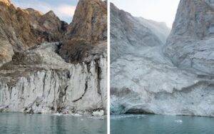
From left to right: before (August 2023) and after (September 2023) photos of the mountain peak and glacier, taken from the fjord. Credit: Søren Rysgaard / Danish Army.

A landslide in a remote part of Greenland caused a mega-tsunami that sloshed back and forth across a fjord for nine days, generating vibrations throughout Earth, according to a new study involving UCL researchers.

The study, published in the journal Science, concluded that this movement of water was the cause of a mysterious, global seismic signal that lasted for nine days and puzzled seismologists in September 2023.

The initial event, not observed by human eye, was the collapse of a 1.2km-high mountain peak into the remote Dickson Fjord beneath, causing a backsplash of water 200 metres in the air, with a wave up to 110 metres high. This wave, extending across 10km of fjord, reduced to seven metres within a few minutes, the researchers calculated, and would have fallen to a few centimetres in the days after.

The team used a detailed mathematical model, recreating the angle of the landslide and the uniquely narrow and bendy fjord, to demonstrate how the sloshing of water would have continued for nine days, with little energy able to escape.

The model predicted that the mass of water would have moved back and forth every 90 seconds, matching the recordings of vibrations travelling in the Earth’s crust all around the globe.

The landslide, the researchers wrote, was a result of the glacier at the foot of the mountain thinning, becoming unable to hold up the rock-face above it. This was ultimately due to climate change. The landslide and tsunami were the first observed in eastern Greenland.

Co-author Dr Stephen Hicks, of UCL Earth Sciences, said: “When I first saw the seismic signal, I was completely baffled. Even though we know seismometers can record a variety of sources happening on Earth’s surface, never before has such a long-lasting, globally travelling seismic wave, containing only a single frequency of oscillation, been recorded. This inspired me to co-lead a large team of scientists to figure out the puzzle.

“Our study of this event amazingly highlights the intricate interconnections between climate change in the atmosphere, destabilisation of glacier ice in the cryosphere, movements of water bodies in the hydrosphere, and Earth’s solid crust in the lithosphere.

“This is the first time that water sloshing has been recorded as vibrations through the Earth’s crust, travelling the world over and lasting several days.”

The mysterious seismic signal — coming from a vibration through the Earth’s crust — was detected by seismometers all over the globe, from the Arctic to Antarctica. It looked completely different to frequency-rich ‘rumbles’ and ‘pings’ from earthquake recordings, as it contained only a single vibration frequency, like a monotonous-sounding hum.

When the study’s authors first discovered the signal, they made a note of it as a “USO”: unidentified seismic object.

At the same time, news of a large tsunami in a remote northeast Greenland fjord reached authorities and researchers working in the area.

The researchers joined forces in a unique multidisciplinary group involving 68 scientists from 40 institutions in 15 countries, combining seismometer and infrasound data, field measurements, on-the-ground and satellite imagery, and simulations of tsunami waves.

The team also used imagery captured by the Danish military who sailed into the fjord just days after the event to inspect the collapsed mountain-face and glacier front along with the dramatic scars left by the tsunami.

It was this combination of local field data and remote, global-scale observations that allowed the team to solve the puzzle and reconstruct the extraordinary cascading sequence of events.

Lead author Dr Kristian Svennevig, from the Geological Survey of Denmark and Greenland (GEUS), said: “When we set out on this scientific adventure, everybody was puzzled and no one had the faintest idea what caused this signal. All we knew was that it was somehow associated with the landslide. We only managed to solve this enigma through a huge interdisciplinary and international effort.”

He added: “As a landslide scientist, an additional interesting aspect of this study is that this is the first-ever landslide and tsunami observed from eastern Greenland, showing how climate change already has major impacts there.”

The team estimated that 25 million cubic metres of rock and ice crashed into the fjord (enough to fill 10,000 Olympic-sized swimming pools).

They confirmed the size of the tsunami, one of the largest seen in recent history, using numerical simulations as well as local data and imagery.

Seventy kilometres away from the landslide, four-metre-high tsunami waves damaged a research base at Ella Ø (island) and destroyed cultural and archaeological heritage sites across the fjord system.

The fjord is on a route commonly used by tourist cruise ships visiting the Greenland fjords. Fortunately, no cruise ships were close to Dickson Fjord on the day of the landslide and tsunami, but if they had been, the consequences of a tsunami wave of that magnitude could have been devastating.

Mathematical models recreating the width and depth of the fjord at very high resolution demonstrated how the distinct rhythm of a mass of water moving back and forth matched the seismic signal.

The study concluded that with rapidly accelerating climate change, it will become more important than ever to characterise and monitor regions previously considered stable and provide early warning of these massive landslide and tsunami events.

Co-author Thomas Forbriger, from Karlsruhe Institute of Technology, said: “We wouldn’t have discovered or been able to analyse this amazing event without networks of high-fidelity broadband seismic stations around the world, which are the only sensors that can truly capture such a unique signal.”

Co-author Anne Mangeney, from Université Paris Cité, Institut de Physique du Globe de Paris, said: “This unique tsunami challenged the classical numerical models that we previously used to simulate just a few hours of tsunami propagation. We had to go to an unprecedentedly high numerical resolution to capture this long-duration event in Greenland. This opens up new avenues in the development of numerical methods for tsunami modelling.”

Reference:
Kristian Svennevig, Stephen P. Hicks, Thomas Forbriger, Thomas Lecocq, Rudolf Widmer-Schnidrig, Anne Mangeney, Clément Hibert, Niels J. Korsgaard, Antoine Lucas, Claudio Satriano, Robert E. Anthony, Aurélien Mordret, Sven Schippkus, Søren Rysgaard, Wieter Boone, Steven J. Gibbons, Kristen L. Cook, Sylfest Glimsdal, Finn Løvholt, Koen Van Noten, Jelle D. Assink, Alexis Marboeuf, Anthony Lomax, Kris Vanneste, Taka’aki Taira, Matteo Spagnolo, Raphael De Plaen, Paula Koelemeijer, Carl Ebeling, Andrea Cannata, William D. Harcourt, David G. Cornwell, Corentin Caudron, Piero Poli, Pascal Bernard, Eric Larose, Eleonore Stutzmann, Peter H. Voss, Bjorn Lund, Flavio Cannavo, Manuel J. Castro-Díaz, Esteban Chaves, Trine Dahl-Jensen, Nicolas De Pinho Dias, Aline Déprez, Roeland Develter, Douglas Dreger, Läslo G. Evers, Enrique D. Fernández-Nieto, Ana M. G. Ferreira, Gareth Funning, Alice-Agnes Gabriel, Marc Hendrickx, Alan L. Kafka, Marie Keiding, Jeffrey Kerby, Shfaqat A. Khan, Andreas Kjær Dideriksen, Oliver D. Lamb, Tine B. Larsen, Bradley Lipovsky, Ikha Magdalena, Jean-Philippe Malet, Mikkel Myrup, Luis Rivera, Eugenio Ruiz-Castillo, Selina Wetter, Bastien Wirtz. A rockslide-generated tsunami in a Greenland fjord rang Earth for 9 days. Science, 2024; 385 (6714): 1196 DOI: 10.1126/science.adm9247

Note: The above post is reprinted from materials provided by University College London.
Doughnut-shaped region found inside Earth’s core deepens understanding of planet’s magnetic field

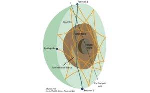
A diagram showing seismic waves traveling through Earth where the newly discovered doughnut-shaped region was detected. Image: Xiaolong Ma and Hrvoje Tkalčić/ANU

A doughnut-shaped region thousands of kilometres beneath our feet within Earth’s liquid core has been discovered by scientists from The Australian National University (ANU), providing new clues about the dynamics of our planet’s magnetic field.

The structure within Earth’s liquid core is found only at low latitudes and sits parallel to the equator. According to ANU seismologists, it has remained undetected until now.

The Earth has two core layers: the inner core, a solid layer, and the outer core, a liquid layer. Surrounding the Earth’s core is the mantle. The newly discovered doughnut-shaped region is at the top of Earth’s outer core, where the liquid core meets the mantle.

Study co-author and ANU geophysicist, Professor Hrvoje Tkalčić, said the seismic waves detected are slower in the newly discovered region than in the rest of the liquid outer core.

“The region sits parallel to the equatorial plane, is confined to the low latitudes and has a doughnut shape,” he said.

“We don’t know the exact thickness of the doughnut, but we inferred that it reaches a few hundred kilometres beneath the core-mantle boundary.”

Rather than using traditional seismic wave observation techniques and observing signals generated by earthquakes within the first hour, the ANU scientists analysed the similarities between waveforms many hours after the earthquake origin times, leading them to make the unique discovery.

“By understanding the geometry of the paths of the waves and how they traverse the outer core’s volume, we reconstructed their travel times through the Earth, demonstrating that the newly discovered region has low seismic speeds,” Professor Tkal?i? said.

“The peculiar structure remained hidden until now as previous studies collected data with less volumetric coverage of the outer core by observing waves that were typically confined within one hour after the origin times of large earthquakes.

“We were able to achieve much better volumetric coverage because we studied the reverberating waves for many hours after large earthquakes.”

Study co-author, Dr Xiaolong Ma, said that the discovery uncovers some mysteries of the dynamics of Earth’s magnetic field.

“There are still mysteries about the Earth’s outer core that are yet to be solved, which requires multidisciplinary efforts from seismology, mineral physics, geomagnetism and geodynamics,” Dr Ma said.

The outer core is predominantly made of liquid iron and nickel, and the vigorous movement of the electrically conductive liquid creates Earth’s magnetic field, which shields around Earth and helps to sustain all life, protecting it from damaging solar winds and harmful radiation.

The scientists believe that knowing more about the Earth’s outer core’s composition, including light chemical elements, is fundamental to understanding the magnetic field and predicting when it could potentially cease or weaken.

“Our findings are interesting because this low velocity within the liquid core implies that we have a high concentration of light chemical elements in these regions that would cause the seismic waves to slow down. These light elements, alongside temperature differences, help stir liquid in the outer core,” Professor Tkalčić said.

“The magnetic field is a fundamental ingredient that we need for life to be sustained on the surface of our planet.

“The dynamics of Earth’s magnetic field is an area of strong interest in the scientific community, so our results could promote more research about the magnetic field on both Earth and other planets.”

The research is published in Science Advances.

Reference:
Xiaolong Ma, Hrvoje Tkalčić. Seismic low-velocity equatorial torus in the Earth’s outer core: Evidence from the late–coda correlation wavefield. Science Advances, 2024; 10 (35) DOI: 10.1126/sciadv.adn5562

Note: The above post is reprinted from materials provided by Australian National University

New sauropod dinosaur from the Cretaceous discovered in the Iberian Peninsula

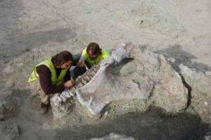
General view of the Lo Hueco site during the excavation of Qunkasaura in 2007. Credit: GBE-UNED

A new study led by Portuguese paleontologist Pedro Mocho, from the Instituto Dom Luiz of the Faculty of Sciences of the University of Lisbon (CIÊNCIAS), has just been published in Communications Biology. It announces a new species of sauropod dinosaur that lived in Cuenca, Spain, 75 million years ago: Qunkasaura pintiquiniestra.

The more than 12,000 fossils collected from 2007 onward during works to install the Madrid-Levante high-speed train (AVE) tracks revealed this deposit, giving rise to one of the most relevant collections of fossil vertebrates from the Upper Cretaceous of Europe.

The collection has been studied continuously thanks to national projects and the Junta de Comunidades de Castilla-La Mancha, which has made it possible to significantly increase our understanding of the ecosystems of southwestern Europe during the Late Cretaceous and also identify several new species for science.

“The study of this specimen allowed us to identify for the first time the presence of two distinct lineages of saltasauroids in the same fossil locality. One of these groups, called Lirainosaurinae, is relatively known in the Iberian region and is characterized by small and medium-sized species, which evolved in an island ecosystem.

“In other words, Europe was a huge archipelago made up of several islands during the Late Cretaceous. However, Qunkasaura belongs to another group of sauropods, represented in the Iberian Peninsula by medium-large species 73 million years ago.

“This suggests to us that this lineage arrived in the Iberian Peninsula much later than other groups of dinosaurs,” explains Mocho.

One of the most relevant features of the Lo Hueco fossil record is the abundance of large partial skeletons of sauropod dinosaurs, which are rare in the rest of Europe.

Qunkasaura pintiquiniestra stands out for being one of the most complete sauropod skeletons found in Europe, including cervical, dorsal and caudal vertebrae, part of the pelvic girdle and elements of the limbs. Their unique morphology, especially in the tail vertebrae, offers new insights into the non-avian dinosaurs of the Iberian Peninsula, a historically poorly understood group.

The study identifies Qunkasaura as a representative of the opisthocoelicaudine saltasaurids, a group present in the northern hemisphere (Laurasia). On the other hand, most Late Cretaceous sauropods from southwestern Europe, including Lohuecotitan pandafilandi, previously described from Lo Hueco, belong to the group Lirainosaurinae, a group of sauropods apparently exclusive to the European continent.

This study suggests that Lo Hueco is the only place where the coexistence of both groups is known and proposes a new group of titanosaurs called Lohuecosauria, which includes representatives of both lineages. Lohuecosaurs may have originated on the southern continents (Gondwana) before dispersing globally.

The name Qunkasaura pintiquiniestra is made up of several geographic and cultural references close to the Lo Hueco site. “Qunka” refers to the oldest etymology of the toponym from the Cuenca and Fuentes area, “Saura” alludes to the feminine of the Latin saurus (lizard), but also pays homage to the painter Antonio Saura, and “pintiquiniestra” refers to the giant “Queen Pintiquiniestra,” character from a novel mentioned in “Don Quijote de la Mancha’ by Cervantes.

“Fortunately, the Lo Hueco deposit also preserves several skeletons of sauropod dinosaurs to be determined, which may correspond to new species and which will help us understand how these animals evolved,” concludes Mocho.

The study is part of the research conducted by the Evolutionary Biology Group at UNED on ecosystems with dinosaurs in central Iberian Peninsula. Part of the skeleton of Qunkasaura is already on display in the Paleontological Museum of Castilla-La Mancha in Cuenca (Spain).

Reference:
Mocho, P, A Spanish saltasauroid titanosaur reveals Europe as a melting pot of endemic and immigrant sauropods in the Late Cretaceous, Communications Biology (2024). DOI: 10.1038/s42003-024-06653-0

Note: The above post is reprinted from materials provided by University of Lisbon.

Fungus gnat entombed in a 40-million-year-old piece of amber is a rare gem

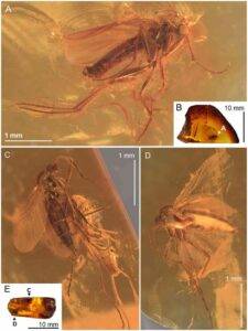
Robsonomyia baltica sp. nov. (NHMD-300551): (A) male (holotype No NHMD-300551a); (B) amber piece with position of male; (C) female (paratype No NHMD-300551b); (D) female (paratype No NHMD-300551c); (E) amber piece with position of females. Credit: Scientific Reports (2024). DOI: 10.1038/s41598-024-59448-y

A Danish amber collector’s find upon a wild North Sea shore in the 1960’s has proved to be of great and surprising significance. After having thoroughly examined the roughly 40-million-year-old piece of amber, University of Copenhagen researchers have discovered it to contain the first fossil of a predatory fungus gnat belonging to a rare genus. The research contributes new knowledge about the distribution of the gnat species and about biodiversity across space and time.

The research is published in the journal Scientific Reports.

Are you fed up with the summertime onslaught of fruit flies, gnats, mosquitoes and other tiny winged insects? If so, be happy that you weren’t around 40 million years ago. Back then, Europe’s climate was warmer and more humid, which provided favorable conditions for gnats, among other things.

One of these gnats, which met its end after being trapped in a lump of pine resin, has given researchers from the Natural History Museum of Denmark the opportunity to add a new prehistoric gnat species to its family of insects. This first fossil of a rare and never before studied species of gnat, Robsonomyia henningseni, was found in a piece of Baltic amber along Denmark’s North Sea coast in the 1960’s.

For decades, the piece had been tucked away in the museum’s 70,000-piece amber collection. Recently, it was retrieved from the drawers and subjected to a thorough examination by a team of Polish entomologists. The insect specialists were able to identify the gnat as an extinct species from a rare genus of predatory gnats. Today, living species of the genus are only found in Hokkaido, Japan and California.

“This is the first time that anyone has found a fossil gnat of this genus, which were only thought to live in Japan and North America. The finding demonstrates that this type of gnat was also widespread in Europe during past climates and gives us new knowledge about the gnat’s distribution on Earth,” explains Alicja Pełczyńska, a Ph.D. student at the University of Łódź and University of Copenhagen, who conducted the description of the gnat.

The researchers believe that the ancient gnat is a kind of “missing link” that connects its two rare and still living relatives in Japan and the United States. The overland distance between the living species has puzzled researchers, but the new fossil demonstrates that the species’ path may have traversed the European continent.

“Until now, the distribution of this genus of gnat has been strange, with many thousands of kilometers between species. Therefore, it makes sense to have found it in Europe, which is approximately halfway between Japan and North America,” says Pełczyńska.

C.V. Henningsen—Danish amber collector and gnat namesake

To learn more about the amber-entombed gnat, the researchers began by polishing the ocean and sun-matted amber piece until it was glossy and transparent.

Once transparent, they used an advanced camera and spectrometer to take a chemical fingerprint of the amber. This confirmed that the piece is from Baltic amber. Thereafter, they examined the fossil and determined the species of insect. This part of the process took place by closely studying the males’ genitalia, where identifying characteristics often vary.

“Insects mate end to end, which places certain demands on their genitalia. The male has appendages, or forceps, next to the actual penis, which it uses to grasp the female gnat with while mating. We used the shape of these forceps to identify it,” explains Lars Vilhelmsen, an associate professor and curator at the Natural History Museum of Denmark.

Based on the analysis, the researchers estimate that the gnat buzzed about in the enormous pine forests of what we now know as Scandinavia some 35–40 million years ago. Here, the gnat became trapped in a lump of resin upon a tree, which rivers, ocean currents and glaciers of the last ice age carried to the North Sea.

“An amber collector by the name of C.V. Henningsen found the piece of amber on the western coast of Jutland back in the 1960’s. Henningsen sold the piece, along with the rest of his collection, to the Natural History Museum of Denmark. Since the gnat species had never been described before, we named it after him, and it is now known as Robsonomyia henningseni,” says Vilhelmsen.

Unlike in Jurassic Park, there’s no DNA

Amber is an outstanding natural time capsule for scientists. With its protective lamination, it preserves ancient insects and plant remains and lets us learn about what Earth looked like up to 230 million years ago. But if released from its amber encasing, the insect will disappear.

According to Vilhelmsen, there is no blood or DNA to suck out of the gnats so as to reanimate them in any way, as is done in the Jurassic Park films.

“Virtually all of the organic material in the gnat has long since decomposed, making it a hollow shell. If one tries to remove it from the amber, it crumbles. As such, the best thing we can do is to study it inside the amber. Insects trapped in amber can be studied almost as precisely as their living relatives using microCT scans,” explains Vilhelmsen.

The new discovery of the gnat fossil equips researchers with new knowledge about the general migrations of gnats across Earth and contributes to the larger picture of biodiversity through time.

Reference:
Alicja Pełczyńska et al, Eocene amber provides the first fossil record and bridges distributional gap in the rare genus Robsonomyia (Diptera: Keroplatidae), Scientific Reports (2024). DOI: 10.1038/s41598-024-59448-y

Note: The above post is reprinted from materials provided by University of Copenhagen.

Plant-eating dinosaurs evolved backup teeth to eat tough food, research reveals

The teeth of Iguanodon weren't as adapted for chewing, and formed much more slowly, than those of their later relatives. Credit: The Trustees of the Natural History Museum, London
The teeth of Iguanodon weren’t as adapted for chewing, and formed much more slowly, than those of their later relatives. Credit: The Trustees of the Natural History Museum, London

At the end of the Cretaceous, the duck-billed hadrosaurs were the most advanced herbivores on Earth. New research has revealed just how voracious these dinosaurs were, with their average tooth worn away in less than two months as they consumed enormous amounts of plants. Some of Earth’s most successful herbivores may have had hundreds of thousands of teeth in their lifetime.

The ornithopods are a group of dinosaurs that include Iguanodon, Hypsilophodon and their relatives, including the rare rhabdodontids. Ornithopods first appeared in the Middle Jurassic but were most prominent in the Cretaceous, when they became the dominant herbivores across large parts of the world.

This journey took them from small generalists to becoming large and specialized “plant-eating machines” which rival modern cows and sheep. The research, led by Dr. Attila Ősi from Eötvös Loránd University in Hungary, shows that the dinosaurs achieved this following the evolution of vast numbers of replacement teeth, which allowed them to eat even the toughest of plants in large quantities.

“The teeth and jaws of the ornithopods changed drastically during their evolution,” Attila says. “Earlier members of the group, like Iguanodon, took more than 200 days to form their teeth and at least that long to wear them down by chewing. But by the end of the Cretaceous, hadrosaurs would wear through their teeth in as little as 50 days.”

“We think this is because the later ornithopods must have been feeding on tough plants that rapidly eroded their teeth. As they wore away at a huge rate, these dinosaurs would have needed to build up banks of teeth in their skulls to stop themselves from starving.”

The findings of the study are published in the journal Nature Communications.

Becoming the top dinosaur herbivores

While herbivory is one of the most common ways of life for animals, it’s surprisingly difficult to eat plants. Unlike meat, which is easily broken down in the gut, plants are generally made up of tough fibers and complex carbohydrates which are hard to digest.

Teeth are on the front line of this dietary battle, breaking open plants and cutting them into smaller pieces so that gut bacteria can break them down more efficiently. However, as co-author Professor Paul Barrett explains, this takes its toll on the teeth.

“Across a herbivore’s life, its teeth gradually wear down,” Paul says. “This puts an upper limit on the life of some mammals, like elephants or cows. Once their teeth are gone, the animal can no longer feed, and so it dies.”

“This isn’t a problem for reptiles. They are able to continually make new teeth, with a replacement ready to surface from beneath as soon as its predecessor wears out. As a result, dinosaur teeth are common fossils, making them a valuable way to investigate how these animals evolved.”

The team were particularly interested in investigating the teeth and jaws of the ornithopods, which eventually became some of the most advanced herbivores to have ever lived on our planet. By examining well-preserved skulls, they were able to track how the dinosaurs’ skulls developed into increasingly complex forms that were better suited to eating plants.

“We can see a sequential increase in the complexity of their adaptations for herbivory as they evolve,” Paul explains. “At the start, they had single rows of fairly simple teeth with limited wear, probably because these dinosaurs focused on fruits and softer plants.”

“By the time the hadrosaurs evolved, they had vastly more teeth which developed a large blade-like edge on one side and a series of ridges behind it. This structure is unique to these dinosaurs, and kept the upper and lower teeth sharp as they ground against each other.”

Later ornithopods also moved their jaws in new ways, being able to slide them back and forth and side to side, allowing them to grind plants down even further. Their bodies also grew much bigger, allowing them to accommodate larger guts that can more effectively release the nutrients inside plants.

Different dinosaurs took different approaches to herbivory. But the team noticed that a few groups of ornithopods, like the tenontosaurids and their more advanced iguanodontian relatives, all follow a strikingly similar evolutionary path. They believe this is an example of convergent evolution.

“About 110 million years ago, these ornithopods rapidly evolved a series of similar characteristics,” Paul explains. “Their teeth increase in number, their jaws interlock more tightly and they build up more replacement teeth, making them more effective herbivores.”

“We also see this happen in the horned dinosaurs, which include species like Triceratops. It’s tempting to speculate that these changes happened for similar reasons.”

Could flowers be responsible?

While the evidence that the environment changed in the Early Cretaceous is strong, finding out exactly what happened is challenging. To try and reveal potential causes, the team examined worn areas of dinosaur teeth, known as wear facets, for signs of microscopic changes.

“Before the Early Cretaceous, ornithopod teeth had a lot of large pits,” Attila says. “This suggests that they were eating a large amount of plant seeds, as well as potentially consuming a lot of dust and soil by feeding close to the ground.”

“Later forms have fewer pits, with many more scratches instead. This suggests that they were now eating harder plants, or feeding in a different way.”

Rather than the dinosaurs actively changing what they ate, one possible explanation could be that certain plants became more common. It’s possible that the rise of flowers could be responsible, but it doesn’t quite fit the available evidence.

“While it is suspicious that the flowering plants start to diversify around this time, they were still pretty uncommon at the time,” Paul says. “In fact, until the Late Cretaceous, horsetails, ferns and conifers would be much more common for dinosaurs looking for something to eat.”

“As it’s very difficult to disentangle the plant and dinosaur fossil records, it’s unlikely we’ll ever have enough detailed evidence to prove there is a link, even if it is a very interesting idea.”

Having finished their work on the ornithopods, the team hope to gradually widen their research to other herbivorous dinosaurs, like the ankylosaurs or the horned dinosaurs. This could give us a better idea of why these reptiles were so successful, and how evolution shaped the diet of the different groups.

“We’d like to be able to sample other dinosaurs to see if the trend of increasing body size, tooth number and the change in teeth wear we found in the ornithopods is more widespread,” Attila says. “If we can find out what changes herbivores were going through at the time, it will give us a much better chance of understanding the place of these dinosaurs in the ecosystems of the Mesozoic Era.”

Reference:
Attila Ősi et al, Trophic evolution in ornithopod dinosaurs revealed by dental wear, Nature Communications (2024). DOI: 10.1038/s41467-024-51697-9

Note: The above post is reprinted from materials provided by Natural History Museum.

Some Pterosaurs Would Flap, Others Would Soar

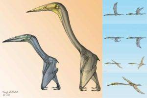
Inabtanin alarabia, left, and Arambourgiania philadelphiae, right. With flying styles also demonstrated. ©Terryl Whitlatch

Some species of pterosaurs flew by flapping their wings while others soared like vultures, demonstrates a new study published in the peer-reviewed Journal of Vertebrate Paleontology.

It has long been debated whether the largest pterosaurs could fly at all.

However, “remarkable” and “rare” three-dimensional fossils of two different large-bodied azhdarchoid pterosaur species — including one new-to-science — have enabled scientists to hypothesize that not only could the largest pterosaurs take to the air, but their flight styles could differ too.

The new findings are led by experts from the University of Michigan, in the US, the Natural Resources Authority and Yarmouk University, in Jordan, and the Saudi Geological Survey, in Saudi Arabia.

Their paper details how these fossils — which date back to the latest Cretaceous period (approximately 72 to 66 million years ago) — were remarkably three-dimensionally preserved within the two different sites that preserve a nearshore environment on the margin of Afro-Arabia, an ancient landmass that included both Africa and the Arabian Peninsula. The research team used high-resolution computed tomography (CT) scans to then analyze the internal structure of the wing bones.

“The dig team was extremely surprised to find three-dimensionally preserved pterosaur bones, this is a very rare occurrence,” explains lead author Dr Kierstin Rosenbach, from the Department of Earth and Environmental Sciences of the University of Michigan.

“Since pterosaur bones are hollow, they are very fragile and are more likely to be found flattened like a pancake, if they are preserved at all.

“With 3D preservation being so rare, we do not have a lot of information about what pterosaur bones look like on the inside, so I wanted to CT scan them.

“It was entirely possible that nothing was preserved inside, or that CT scanners were not sensitive enough to differentiate fossil bone tissue from the surrounding matrix.”

Luckily, though, what the team uncovered was “remarkable,” via “exciting internal structures not only preserved, but visible in the CT scanner.”

CT scans reveal one soars; one flaps!

Newly collected specimens of the already-known giant pterosaur, Arambourgiania philadelphiae, confirm its 10-meter wingspan and provide the first details of its bone structure. CT images revealed that the interior of its humerus, which is hollow, contains a series of ridges that spiral up and down the bone.

This resembles structures in the interior of wing bones of vultures. The spiral ridges are hypothesized to resist the torsional loadings associated with soaring (sustained powered flight that requires launch and maintenance flapping).

The other specimen analyzed was the new-to-science Inabtanin alarabia, which had a five-meter wingspan. The team named it after the place where it was excavated — near a large grape-colored hill, called Tal Inab. The generic name combines the Arabic words “inab,” for grape, and “tanin” for dragon. ‘Alarabia’ refers to the Arabian Peninsula.

Inabtanin is one of the most complete pterosaurs ever recovered from Afro-Arabia, and the CT scans revealed the structure of its flight bones was completely different from that of Arambourgiania.

The interior of the flight bones were crisscrossed by arrangement with struts that match those found in the wing bones of modern flapping birds.

This indicates it was adapted to resist bending loads associated with flapping flight, and so it is likely that Inabtanin flew this way — although this does not preclude occasional use of other flight styles too.

“The struts found in Inabtanin were cool to see, though not unusual,” says Dr Rosenbach.

“The ridges in Arambourgiania were completely unexpected, we weren’t sure what we were seeing at first!

“Being able to see the full 3D model of Arambourgiania’s humerus lined with helical ridges was just so exciting.”

What explains this difference?

The discovery of diverse flight styles in differently-sized pterosaurs is “exciting,” the experts state, because it opens a window into how these animals lived. It also poses interesting questions, like to what extent flight style is correlated with body size and which flight style is more common among pterosaurs.

“There is such limited information on the internal bone structure of pterosaurs across time, it is difficult to say with certainty which flight style came first,” Dr Rosenbach adds.

“If we look to other flying vertebrate groups, birds and bats, we can see that flapping is by far the most common flight behavior.

“Even birds that soar or glide require some flapping to get in the air and maintain flight.

“This leads me to believe that flapping flight is the default condition, and that the behavior of soaring would perhaps evolve later if it were advantageous for the pterosaur population in a specific environment; in this case the open ocean.”

Co-author Professor Jeff Wilson Mantilla, Curator at Michigan’s Museum of Paleontology, and Dr Iyad Zalmout, from the Saudi Geological Survey, found these specimens in 2007 at sites in the north and south of Jordan.

Professor Jeff Wilson Mantilla says the “variations likely reflect responses to mechanical forces applied on the pterosaurs’ wings during flight.”

Enabling further study of vertebrate flight

Concluding, Dr Rosenbach states: “Pterosaurs were the earliest and largest vertebrates to evolve powered flight, but they are the only major volant group that has gone extinct.

“Attempts to-date to understand their flight mechanics have relied on aerodynamic principles and analogy with extant birds and bats.

“This study provides a framework for further investigation of the correlation between internal bone structure and flight capacity and behavior, and will hopefully lead to broader sampling of flight bone structure in pterosaur specimens.”

Journal Reference:
Kierstin L. Rosenbach, Danielle M. Goodvin, Mohammed G. Albshysh, Hassan A. Azzam, Ahmad A. Smadi, Hakam A. Mustafa, Iyad S. A. Zalmout, Jeffrey A. Wilson Mantilla. New pterosaur remains from the Late Cretaceous of Afro-Arabia provide insight into flight capacity of large pterosaurs. Journal of Vertebrate Paleontology, 2024; DOI: 10.1080/02724634.2024.2385068

Note: The above post is reprinted from materials provided by Taylor & Francis Group.

Chemists explain why dinosaur collagen may have survived for millions of years

A new study from MIT offers an explanation for how dinosaur collagen survived for so much longer than expected.Credits:Credit: MIT News, iStock
A new study from MIT offers an explanation for how dinosaur collagen survived for so much longer than expected.
Credits:Credit: MIT News, iStock

Collagen, a protein found in bones and connective tissue, has been found in dinosaur fossils as old as 195 million years. That far exceeds the normal half-life of the peptide bonds that hold proteins together, which is about 500 years.

A new study from MIT offers an explanation for how collagen can survive for so much longer than expected. The research team found that a special atomic-level interaction defends collagen from attack by water molecules. This barricade prevents water from breaking the peptide bonds through a process called hydrolysis.

“We provide evidence that that interaction prevents water from attacking the peptide bonds and cleaving them. That just flies in the face of what happens with a normal peptide bond, which has a half-life of only 500 years,” says Ron Raines, the Firmenich Professor of Chemistry at MIT.

Raines is the senior author of the new study, which will appear in ACS Central Science. MIT postdoc Jinyi Yang PhD ’24 is the lead author of the paper. MIT postdoc Volga Kojasoy and graduate student Gerard Porter are also authors of the study.

Water-resistant

Collagen is the most abundant protein in animals, and it is found in not only bones but also skin, muscles, and ligaments. It’s made from long strands of protein that intertwine to form a tough triple helix.

“Collagen is the scaffold that holds us together,” Raines says. “What makes the collagen protein so stable, and such a good choice for this scaffold, is that unlike most proteins, it’s fibrous.”

In the past decade, paleobiologists have found evidence of collagen preserved in dinosaur fossils, including an 80-million-year-old Tyrannosaurus rex fossil, and a sauropodomorph fossil that is nearly 200 million years old.

Over the past 25 years, Raines’ lab has been studying collagen and how its structure enables its function. In the new study, they revealed why the peptide bonds that hold collagen together are so resistant to being broken down by water.

Peptide bonds are formed between a carbon atom from one amino acid and a nitrogen atom of the adjacent amino acid. The carbon atom also forms a double bond with an oxygen atom, forming a molecular structure called a carbonyl group. This carbonyl oxygen has a pair of electrons that don’t form bonds with any other atoms. Those electrons, the researchers found, can be shared with the carbonyl group of a neighboring peptide bond.

Because this pair of electrons is being inserted into those peptide bonds, water molecules can’t also get into the structure to disrupt the bond.

To demonstrate this, Raines and his colleagues created two interconverting mimics of collagen — the one that usually forms a triple helix, which is known as trans, and another in which the angles of the peptide bonds are rotated into a different form, known as cis. They found that the trans form of collagen did not allow water to attack and hydrolyze the bond. In the cis form, water got in and the bonds were broken.

“A peptide bond is either cis or trans, and we can change the cis to trans ratio. By doing that, we can mimic the natural state of collagen or create an unprotected peptide bond. And we saw that when it was unprotected, it was not long for the world,” Raines says.

“No weak link”

This sharing of electrons has also been seen in protein structures known as alpha helices, which are found in many proteins. These helices may also be protected from water, but the helices are always connected by protein sequences that are more exposed, which are still susceptible to hydrolysis.

“Collagen is all triple helices, from one end to the other,” Raines says. “There’s no weak link, and that’s why I think it has survived.”

Previously, some scientists have suggested other explanations for why collagen might be preserved for millions of years, including the possibility that the bones were so dehydrated that no water could reach the peptide bonds.

“I can’t discount the contributions from other factors, but 200 million years is a long time, and I think you need something at the molecular level, at the atomic level in order to explain it,” Raines says.

The research was funded by the National Institutes of Health and the National Science Foundation.

Journal Reference:
Jinyi Yang, Volga Kojasoy, Gerard J. Porter, Ronald T. Raines. Pauli Exclusion by n→π* Interactions: Implications for Paleobiology. ACS Central Science, 2024; DOI: 10.1021/acscentsci.4c00971

Note: The above post is reprinted from materials provided by Massachusetts Institute of Technology. Original written by Anne Trafton

What microscopic fossilized shells tell us about ancient climate change

Images of forams created by a scanning electronic microscope. Credit: Dustin Harper

At the end of the Paleocene and beginning of the Eocene epochs, between 59 to 51 million years ago, Earth experienced dramatic warming periods, both gradual periods stretching millions of years and sudden warming events known as hyperthermals.

Driving this planetary heat up were massive emissions of carbon dioxide (CO2) and other greenhouse gases, but other factors like tectonic activity may have also been at play.

New research led by University of Utah geoscientists pairs sea surface temperatures with levels of atmospheric CO2 during this period, showing the two were closely linked. The findings also provide case studies to test carbon cycle feedback mechanisms and sensitivities critical for predicting anthropogenic climate change as we continue pouring greenhouse gases into the atmosphere on an unprecedented scale in the planet’s history.

“The main reason we are interested in these global carbon release events is because they can provide analogs for future change,” said lead author Dustin Harper, a postdoctoral researcher in the Department of Geology & Geophysics. “We really don’t have a perfect analog event with the exact same background conditions and rate of carbon release.”

But the study published Monday in the Proceedings of the National Academy of Sciences, or PNAS, suggests emissions during two ancient “thermal maxima” are similar enough with today’s anthropogenic climate change to help scientists forecast its consequences.

The research team analyzed microscopic fossils — recovered in drilling cores taken from an undersea plateau in the Pacific — to characterize surface ocean chemistry at the time the shelled creatures were alive. Using a sophisticated statistical model, they reconstructed sea surface temperatures and atmospheric CO2 levels over a 6-million-year period that covered two hyperthermals, the Paleocene-Eocene Thermal Maximum, or PETM, 56 million years ago and Eocene Thermal Maximum 2, ETM-2, 54 million years ago.

The findings indicate that as atmospheric levels of CO2 rose, so too did global temperatures.

“We have multiple ways that our planet, that our atmosphere is being influenced by CO2 additions, but in each case, regardless of the source of CO2, we’re seeing similar impacts on the climate system,” said co-author Gabriel Bowen, a U professor of geology & geophysics.

“We’re interested in how sensitive the climate system was to these changes in CO2. And what we see in this study is that there’s some variation, maybe a little lower sensitivity, a lower warming associated with a given amount of CO2 change when we look at these very long-term shifts. But that overall, we see a common range of climate sensitivities.”

Today, human activities associated with fossil fuels are releasing carbon 4 to 10 times more rapidly than occurred during these ancient hyperthermal events. However, the total amount of carbon released during the ancient events is similar to the range projected for human emissions, potentially giving researchers a glimpse of what could be in store for us and future generations.

First scientists must determine what happened to the climate and oceans during these episodes of planetary heating more than 50 million years ago.

“These events might represent a mid- to worst-case scenario kind of case study,” Harper said. “We can investigate them to answer what’s the environmental change that happens due to this carbon release?”

Earth was very warm during the PETM. No ice sheets covered the poles and ocean temperatures in the mid-90s degrees Fahrenheit.

To determine oceanic CO2 levels the researchers turned to fossilized remains of foraminifera, a shelled single-cell organism akin to plankton. The research team based the study on cores previously extracted by the International Ocean Discovery Program at two locations in Pacific.

The foram shells accumulate small amounts of boron, the isotopes of which are a proxy reflecting CO2 concentrations in the ocean at the time the shells formed, according to Harper.

“We measured the boron chemistry of the shells, and we’re able to translate those values using modern observations to past seawater conditions. We can get at seawater CO2 and translate that into atmospheric CO2,” Harper said. “The goal of the target study interval was to establish some new CO2 and temperature records for the PETM and ETM-2, which represent two of the best analogs in terms of modern change, and also provide a longer-term background assessment of the climate system to better contextualize those events.”

The cores Harper studied were extracted from Shatsky Rise in the subtropical North Pacific, which is an ideal location for recovering ocean-bottom sediments that reflect conditions in the ancient past.

Carbonate shells dissolve if they settle into deep ocean, so scientists must look to underwater plateaus like Shatsky Rise, where the water depths are relatively shallow. While their inhabitants were living millions of years ago, the foraminifera shells record the sea surface conditions.

“Then they die and sink to the sea floor, and they’re deposited in about two kilometers of water depth,” Harper said. “We’re able to retrieve the complete sequence of the dead fossils. At these places in the middle of the ocean, you really don’t have a lot of sediment supply from continents, so it is predominantly these fossils and that’s all. It makes for a really good archive for what we want to do.”

Journal Reference:
Dustin T. Harper, Bärbel Hönisch, Gabriel J. Bowen, Richard E. Zeebe, Laura L. Haynes, Donald E. Penman, James C. Zachos. Long- and short-term coupling of sea surface temperature and atmospheric CO 2 during the late Paleocene and early Eocene. Proceedings of the National Academy of Sciences, 2024; 121 (36) DOI: 10.1073/pnas.2318779121

Note: The above post is reprinted from materials provided by University of Utah. Original written by Brian Maffly.

Matching dinosaur footprints found on opposite sides of the Atlantic Ocean

L. Theropod footprint from Sousa Basin, Lower Cretaceous of Northeastern Brazil. Credit: Ismar de Souza Carvalho. R. Theropod tracks from the Koum Basin in Cameroon. Credit: SMU.

An international team of researchers led by SMU paleontologist Louis L. Jacobs has found matching sets of Early Cretaceous dinosaur footprints on what are now two different continents.

More than 260 footprints were discovered in Brazil and in Cameroon, showing where land-dwelling dinosaurs were last able to freely cross between South America and Africa millions of years ago before the two continents split apart.

“We determined that in terms of age, these footprints were similar,” Jacobs said. “In their geological and plate tectonic contexts, they were also similar. In terms of their shapes, they are almost identical.”

The footprints, impressed into mud and silt along ancient rivers and lakes, were found more than 3,700 miles, or 6,000 kilometers, away from each other. Dinosaurs made the tracks 120 million years ago on a single supercontinent known as Gondwana — which broke off from the larger landmass of Pangea, Jacobs said.

“One of the youngest and narrowest geological connections between Africa and South America was the elbow of northeastern Brazil nestled against what is now the coast of Cameroon along the Gulf of Guinea,” Jacobs explained. “The two continents were continuous along that narrow stretch, so that animals on either side of that connection could potentially move across it.”

Most of the dinosaur fossils were created by three-toed theropod dinosaurs.. A few were also likely made by sauropods or ornithischians, said Diana P. Vineyard, who is a research associate at SMU and co-author of the study.

Other co-authors of the study were Lawrence J. Flynn in the Department of Human Evolutionary Biology at Harvard University, Christopher R. Scotese in the Department of Earth and Planetary Sciences at Northwestern University and Ismar de Souza Carvalho at the Universidade Federal do Rio de Janeiro and Centro de Geociências.

The study was published by New Mexico Museum of Natural History & Science in a tribute to the late paleontologist Martin Lockley, who spent much of his career studying dinosaurs tracks and footprints.

Dinosaur footprints tell the whole story

Africa and South America started to split around 140 million years ago, causing gashes in Earth’s crust called rifts to open up along pre-existing weaknesses. As the tectonic plates beneath South America and Africa moved apart, magma from the Earth’s mantle rose to the surface, creating new oceanic crust as the continents moved away from each other. And eventually, the South Atlantic Ocean filled the void between these two newly-shaped continents.

Signs of some of those major events were evident between both locations where the dinosaur footprints were found — at the Borborema region in the northeast part of Brazil and the Koum Basin in northern Cameroon. Half-graben basins — geologic structures formed during rifting as the Earth’s crust pulls apart and faults form — are found in both areas and contain ancient river and lake sediments. Along with dinosaur tracks, these sediments contain fossil pollen that indicate an age of 120 million years.

Before the continental connection between Africa and South America was severed, “rivers flowed and lakes formed in the basins” Jacobs said. “Plants fed the herbivores and supported a food chain. Muddy sediments left by the rivers and lakes contain dinosaur footprints, including those of meat-eaters, documenting that these river valleys could provide specific avenues for life to travel across the continents 120 million years ago.”

Note: The above post is reprinted from materials provided by Southern Methodist University.

Tracking down the asteroid that sealed the fate of the dinosaurs

Illustrated scene of dinosaurs and asteroid.
Illustrated scene of dinosaurs and asteroid. (© stock.adobe.com)

Geoscientists from the University of Cologne have led an international study to determine the origin of the huge piece of rock that hit the Earth around 66 million years ago and permanently changed the climate. The scientists analysed samples of the rock layer that marks the boundary between the Cretaceous and Paleogene periods. This period also saw the last major mass extinction event on Earth, in which around 70 percent of all animal species became extinct. The results of the study published in Science indicate that the asteroid formed outside Jupiter’s orbit during the early development of our solar system.

According to a widely accepted theory, the mass extinction at the Cretaceous-Paleogene boundary was triggered by the impact of an asteroid at least 10 kilometres in diameter near Chicxulub on the Yucatán Peninsula in Mexico.

On impact, the asteroid and large quantities of earth rock vaporized.

Fine dust particles spread into the stratosphere and obscured the sun.

This led to dramatic changes in the living conditions on the planet and brought photosynthetic activity to a halt for several years.

The dust particles released by the impact formed a layer of sediment around the entire globe.

This is why the Cretaceous-Paleogene boundary can be identified and sampled in many places on Earth.

It contains high concentrations of platinum-group metals, which come from the asteroid and are otherwise extremely rare in the rock that forms the Earth’s crust.

By analysing the isotopic composition of the platinum metal ruthenium in the cleanroom laboratory of the University of Cologne’s Institute of Geology and Mineralogy, the scientists discovered that the asteroid originally came from the outer solar system.

“The asteroid’s composition is consistent with that of carbonaceous asteroids that formed outside of Jupiter’s orbit during the formation of the solar system,” said Dr Mario Fischer-Gödde, first author of the study.

The ruthenium isotope compositions were also determined for other craters and impact structures of different ages on Earth for comparison. This data shows that within the last 500 million years, almost exclusively fragments of S-type asteroids have hit the Earth. In contrast to the impact at the Cretaceous-Paleogene boundary, these asteroids originate from the inner solar system. Well over 80 percent of all asteroid fragments that hit the Earth in the form of meteorites come from the inner solar system. Professor Dr Carsten Münker, co-author of the study, added: “We found that the impact of an asteroid like the one at Chicxulub is a very rare and unique event in geological time. The fate of the dinosaurs and many other species was sealed by this projectile from the outer reaches of the solar system.”

Reference:
Mario Fischer-Gödde, Jonas Tusch, Steven Goderis, Alessandro Bragagni, Tanja Mohr-Westheide, Nils Messling, Bo-Magnus Elfers, Birger Schmitz, Wolf U. Reimold, Wolfgang D. Maier, Philippe Claeys, Christian Koeberl, François L. H. Tissot, Martin Bizzarro, Carsten Münker. Ruthenium isotopes show the Chicxulub impactor was a carbonaceous-type asteroid. Science, 2024; 385 (6710): 752 DOI: 10.1126/science.adk4868

Note: The above post is reprinted from materials provided by University of Cologne.

Decoding mysterious seismic signals

Earth’s interior. Credit: Michael Thorne

For the decades since their discovery, seismic signals known as PKP precursors have challenged scientists. Regions of Earth’s lower mantle scatter incoming seismic waves, which return to the surface as PKP waves at differing speeds.

The origin the precursor signals, which arrive ahead of the main seismic waves that travel through Earth’s core, has remained unclear, but research led by University of Utah geophysicists sheds new light on this mysterious seismic energy.

PKP precursors appear to propagate from places deep below North America and the western Pacific and possibly bear an association with “ultra-low velocity zones,” thin layers in the mantle where seismic waves significantly slow down, according to research published in AGU Advances, the American Geophysical Union’s lead journal. (The AGU highlighted the research in its magazine Eos.)

“These are some of the most extreme features discovered on the planet. We legitimately do not know what they are,” said lead author Michael Thorne, a U associate professor of geology and geophysics. “But one thing we know is they seem to end up accumulating underneath hotspot volcanoes. They seem like they may be the root of whole mantle plumes giving rise to hotspot volcanoes.”

These plumes are responsible for the volcanism observed at Yellowstone, the Hawaiian Islands, Samoa, Iceland and the Galapagos Islands.

“These really, really big volcanoes seem to persist for hundreds of millions of years in roughly the same spot,” Thorne said. In previous work, he also found one of the world’s largest known ultra-low velocity zones.

“It sits right beneath Samoa, and Samoa is one of the biggest hotspot volcanoes,” Thorne noted.

For nearly a century, geoscientists have used seismic waves to probe Earth’s interior, leading to numerous discoveries that would not be otherwise possible. Other researchers at the U, for example, have characterized the structure of Earth’s solid inner core and tracked its movement by analyzing seismic waves.

When an earthquake rattles Earth’s surface, seismic waves shoot through the mantle — the 2,900-kilometer-thick dynamic layer of hot rock between Earth’s crust and metal core. Thorne’s team is interested in those that get “scattered” when they pass through irregular features that pose changes in material composition in the mantle. Some of those scattered waves become PKP precursors.

Thorne sought to determine exactly where this scattering happens, especially since the waves travel through Earth’s mantle twice, that is, before and after passing through Earth’s liquid outer core. Because of that double journey through the mantle, it has been nearly impossible to distinguish whether the precursors originated on the source-side or receiver-side of the ray path.

Thorne’s team, which included research assistant professor Surya Pachhai, devised a way to model waveforms to detect crucial effects that previously went unnoticed.

Using a cutting-edge seismic array method and new theoretical observations from earthquake simulations, the researchers developed, they analyzed data from 58 earthquakes that occurred around New Guinea and were recorded in North America after passing through the planet.

“I can put virtual receivers anywhere on the surface of the earth, and this tells me what the seismogram should look like from an earthquake at that location. And we can compare that to the real recordings that we have,” Thorne said. “We’re able to now back project where this energy’s coming from.”

Their new method allowed them to pinpoint where the scattering occurred along the boundary between the liquid metal outer core and the mantle, known as the core-mantle boundary, located 2,900 kilometers below Earth’s surface.

Their findings indicate that the PKP precursors likely come from regions that are home to ultra-low velocity zones. Thorne suspects these layers, which are only 20 to 40 kilometers thick, are formed where subducted tectonic plates impinge on the core-mantle boundary in oceanic crust.

“What we’ve now found is that these ultra-low velocity zones do not just exist beneath the hotspots. They’re spread out all across the core-mantle boundary beneath North America,” Thorne said. “It really looks like these ULVZs are getting actively generated. We don’t know how. But because we’re seeing them near subduction, we think mid-ocean ridge basalts are getting melted, and that is how it’s getting generated. And then the dynamics is pushing these things all across Earth, and ultimately they’re going to accumulate beneath the hotspots.”

“What we’ve now found is that these ultra-low velocity zones do not just exist beneath the hotspots. They’re spread out all across the core-mantle boundary beneath North America,” Thorne said. “It really looks like these ULVZs are getting actively generated. We don’t know how. But because we’re seeing them near subduction, we think mid-ocean ridge basalts are getting melted, and that may be how they’re getting generated.”

The dynamics is pushing these things all across Earth, and ultimately, they’re going to accumulate against the boundaries of Large Low Velocity Provinces, which are compositionally distinct continent scale features beneath the Pacific and Africa, according to Thorne.

“They may additionally accumulate beneath the hotspots, but it is unclear if these ULVZs are generated by the same process,” he said. Determining the consequences of such a process will have to wait for future research.

Reference:
Michael S. Thorne, Surya Pachhai, Mingming Li, Jamie Ward, Sebastian Rost. Investigating Ultra‐Low Velocity Zones as Sources of PKP Scattering Beneath North America and the Western Pacific Ocean: Potential Links to Subducted Oceanic Crust. AGU Advances, 2024; 5 (4) DOI: 10.1029/2024AV001265

Note: The above post is reprinted from materials provided by University of Utah. Original written by Brian Maffly.

Scottish and Irish rocks confirmed as rare record of ‘snowball Earth’

An outcrop called ‘the Bubble’ on Eileach an Naoimh (Holy Isle). It shows a huge white rock fragment, tens of metres across, which was originally part of the underlying rock sequence. The layering in the carbonate rock has been squeezed tightly under immense pressure and transported by thick ice sheets to its final resting as one of many different rock fragments within a moraine. Credit: Graham Shields

A rock formation spanning Ireland and Scotland may be the world’s most complete record of “snowball Earth,” a crucial moment in planetary history when the globe was covered in ice, finds a new study led by UCL (University College London) researchers.

The study, published in the Journal of the Geological Society of London, found that the Port Askaig Formation, composed of layers of rock up to 1.1km thick, was likely laid down between 662 to 720 million years ago during the Sturtian glaciation — the first of two global freezes thought to have triggered the development of complex, multicellular life.

One exposed outcrop of the formation, found on Scottish islands called the Garvellachs, is unique as it shows the transition into “snowball Earth” from a previously warm, tropical environment.

Other rocks that formed at a similar time, for instance in North America and Namibia, are missing this transition.

Senior author Professor Graham Shields, of UCL Earth Sciences, said: “These rocks record a time when Earth was covered in ice. All complex, multicellular life, such as animals, arose out of this deep freeze, with the first evidence in the fossil record appearing shortly after the planet thawed.”

First author Elias Rugen, a PhD candidate at UCL Earth Sciences, said: “Our study provides the first conclusive age constraints for these Scottish and Irish rocks, confirming their global significance.

“The layers of rock exposed on the Garvellachs are globally unique. Underneath the rocks laid down during the unimaginable cold of the Sturtian glaciation are 70 metres of older carbonate rocks formed in tropical waters. These layers record a tropical marine environment with flourishing cyanobacterial life that gradually became cooler, marking the end of a billion years or so of a temperate climate on Earth.

“Most areas of the world are missing this remarkable transition because the ancient glaciers scraped and eroded away the rocks underneath, but in Scotland by some miracle the transition can be seen.”

The Sturtian glaciation lasted approximately 60 million years and was one of two big freezes that occurred during the Cryogenian Period (between 635 and 720 million years ago). For billions of years prior to this period, life consisted only of single-celled organisms and algae.

After this period, complex life emerged rapidly, in geologic terms, with most animals today similar in fundamental ways to the types of life forms that evolved more than 500 million years ago.

One theory is that the hostile nature of the extreme cold may have prompted the emergence of altruism, with single-celled organisms learning to co-operate with each other, forming multicellular life.

The advance and retreat of the ice across the planet was thought to have happened relatively quickly, over thousands of years, because of the albedo effect — that is, the more ice there is, the more sunlight is reflected back into space, and vice versa.

Professor Shields explained: “The retreat of the ice would have been catastrophic. Life had been used to tens of millions of years of deep freeze. As soon as the world warmed up, all of life would have had to compete in an arms race to adapt. Whatever survived were the ancestors of all animals.”

For the new study, the research team collected samples of sandstone from the 1.1km-thick Port Askaig Formation as well as from the older, 70-metre thick Garbh Eileach Formation underneath.

They analysed tiny, extremely durable minerals in the rock called zircons. These can be precisely dated as they contain the radioactive element uranium, which converts (decays) to lead at a steady rate. The zircons together with other geochemical evidence suggest the rocks were deposited between 662 and 720 million years ago.

The researchers said the new age constraints for the rocks may provide the evidence needed for the site to be declared as a marker for the start of the Cryogenian Period.

This marker, known as a Global Boundary Stratotype Section and Point (GSSP), is sometimes referred to as a golden spike, as a gold spike is driven into the rock to mark the boundary.

GSSPs attract visitors from around the world and in some cases museums have been established at the sites.

A group from the International Commission on Stratigraphy, a part of the International Union of Geological Sciences, visited the Garvellachs in July to assess the case for a golden spike on the archipelago. Currently, the islands are only accessible by chartering a boat or by sailing or kayaking to them.

The study involved researchers from UCL, the University of Milano-Bicocca, Italy, and Birkbeck University of London. The work was funded by the Natural Environment Research Council (NERC).

Reference:
Elias J. Rugen, Guido Pastore, Pieter Vermeesch, Anthony M. Spencer, David Webster, Adam G. G. Smith, Andrew Carter, Graham A. Shields. Glacially influenced provenance and Sturtian affinity revealed by detrital zircon U–Pb ages from sandstones in the Port Askaig Formation, Dalradian Supergroup. Journal of the Geological Society, 2024; 181 (5) DOI: 10.1144/jgs2024-029

Note: The above post is reprinted from materials provided by University College London.
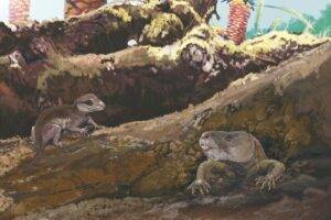
MOST POPULAR

MORE ARTICLES