Home Blog Page 13

Researchers unveil mysteries of ancient Earth

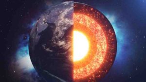
Structure layers of the earth.

A team of researchers has made strides in understanding the formation of massif-type anorthosites, enigmatic rocks that only formed during the middle part of Earth’s history. These plagioclase-rich igneous rock formations, which can cover areas as large as 42,000 square kilometers and host titanium ore deposits, have puzzled scientists for decades due to conflicting theories about their origins.

A new study published in Science Advances on Aug. 14 highlights the intricate connections between Earth’s evolving mantle and crust and the tectonic forces that have shaped the planet throughout its history. It also provides new ways to explore when plate tectonics began, how subduction dynamics operated billions of years ago and the evolution of Earth’s crust.

The research team, led by Rice’s Duncan Keller and Cin-Ty Lee, studied massif-type anorthosites to test ideas about the magmas that formed them. The research focused on the Marcy and Morin anorthosites, classic examples from North America’s Grenville orogen that are about 1.1 billion years old.

By analyzing the isotopes of boron, oxygen, neodymium and strontium in the rocks as well as conducting petrogenetic modeling, the researchers discovered that the magmas that formed these anorthosites were rich in melts derived from oceanic crust altered by seawater at low temperatures. They also found isotopic signatures corresponding to other subduction zone rocks such as abyssal serpentinite.

“Our research indicates that these giant anorthosites likely originated from the extensive melting of subducted oceanic crust beneath convergent continental margins,” said Keller, the Clever Planets Postdoctoral Research Associate, Earth, Environmental and Planetary Sciences and the study’s lead author. “Because the mantle was hotter in the past, this process directly connects the formation of massif-type anorthosites to Earth’s thermal and tectonic evolution.”

The study, which combines classical methods with the novel application of boron isotopic analysis to massif-type anorthosites, suggests that these rocks formed during very hot subduction that may have been prevalent billions of years ago.

Because massif-type anorthosites don’t form on Earth today, the new evidence linking these rocks to very hot subduction on the early Earth opens new interdisciplinary approaches for understanding how these rocks chronicle the physical evolution of our planet.

“This research advances our understanding of ancient rock formations and sheds light on the broader implications for Earth’s tectonic and thermal history,” said Lee, the Harry Carothers Wiess Professor of Geology, professor of Earth, environmental and planetary sciences and study co-author.

The study’s other co-authors include William Peck of the Department of Earth and Environmental Geosciences at Colgate University; Brian Monteleone of the Department of Geology and Geophysics at Woods Hole Oceanographic Institution; Céline Martin of the Department of Earth and Planetary Sciences at the American Museum of Natural History; Jeffrey Vervoort of the School of the Environment at Washington State University; and Louise Bolge of the Lamont-Doherty Earth Observatory at Columbia University.

This study was supported by NASA and the U.S. National Science Foundation.

Reference:
Duncan S. Keller, Cin-Ty A. Lee, William H. Peck, Brian D. Monteleone, Céline Martin, Jeffrey D. Vervoort, Louise Bolge. Mafic slab melt contributions to Proterozoic massif-type anorthosites. Science Advances, 2024; 10 (33) DOI: 10.1126/sciadv.adn3976

Note: The above post is reprinted from materials provided by Rice University.
Water delivered to the mantle by aluminum enriched hydrated slabs?

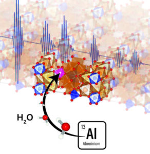
Effect of Al + H incorporation on the sound velocities of superhydrous phase BSchematic representation of the incorporation of aluminum together with water (as Al + H) in the crystal structure of superhydrous phase B. credit : Geodynamics Research Center, Ehime University
Effect of Al + H incorporation on the sound velocities of superhydrous phase B
Schematic representation of the incorporation of aluminum together with water (as Al + H) in the crystal structure of superhydrous phase B.
credit : Geodynamics Research Center, Ehime University

Researchers at the Geodynamics Research Center (GRC), Ehime University, found a notable effect of aluminum on the sound velocities of superhydrous phase B, a dense hydrous magnesium silicate and potential host of water in the deep Earth. Their results, which employed X-ray synchrotron radiation and ultrasonic measurements in a large volume press apparatus, suggest that aluminous phase B could explain seismic velocity anomalies in the Earth’s mantle transition region and uppermost lower mantle.

Dense Hydrous Magnesium Silicates (DHMSs) are generally considered as primary water carriers from the shallow lithosphere to the deep mantle transition region (MTR; 410-660 km in depth). Among DHMSs, Superhydrous phase B (hereafter, SuB) holds the chemical formula, Mg10Si3H3O18. This phase is believed to hold a large amount of water and thus may have an important role in the water storage capacity of the MTR and the transportation of water to the deeper parts of the Earth’s interior; but because of its relative instability against the high temperature of the Earth’s mantle, SuB is generally associated with cold regions, such as the inner parts of the subducted slab.

A recent experimental study conducted at Ehime University, however, showed that when aluminum incorporates SuB, its stability against temperature is drastically improved (Kakizawa et al., AmMin 2018), allowing this mineral to remain stable at pressure and temperature conditions matching those of the Earth’s lower mantle.

In 2022, the same Ehime University research team reported the longitudinal (VP) and shear (VS) velocities of SuB (Xu et al., GRL 2022) using the X-ray and ultrasonic techniques implemented in a multi-anvil apparatus at the beamline BL04B1, located at the synchrotron facility, SPring-8, in Japan.

The results showed that the presence of SuB could be correlated with the low seismic velocities observed in subducted slab regions.

This time, they carried out similar high pressure and high temperature measurements on SuB samples doped with aluminum.

Their new data suggest that incorporation of aluminum in SuB promotes unusual variations of velocities with an increase in water content compared to the velocities of SuB without aluminum.

This new finding, in addition to the knowledge that the stability against temperature and capacity to store water of SuB are improved when aluminum is present in its structure, suggests that the Al-bearing SuB may account for seismically visible anomalies at the bottom of the MTR and beneath subduction zones in the uppermost lower mantle. These results should greatly contribute to tracing the existence and recycling of the former hydrated lithospheric crust in the Earth’s lower mantle and interpreting seismic velocities in terms of mantle composition, and estimate the amount of water that could be passed down to the deep mantle.

Reference:
Chaowen Xu, Steeve Gréaux, Ying Li, Fengxia Sun, Jing Gao, Fei Qin, Toru Inoue. Effect of Al‐Incorporation on the Sound Velocities of Superhydrous Phase B at High Pressure and High Temperature. Geophysical Research Letters, 2024; 51 (12) DOI: 10.1029/2023GL107818

Note: The above post is reprinted from materials provided by Ehime University.

Scientists uncover hidden forces causing continents to rise

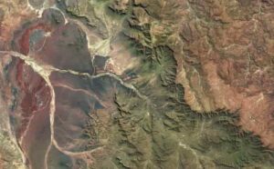
Satellite image of the Great Escarpment in southern Africa from the Sentinel Hub Earth Observation Browser. Taken using the Sentinel-2 L1C dataset, in May 2020. Credit: Prof Tom Gernon, University of Southampton.

Scientists at the University of Southampton have answered one of the most puzzling questions in plate tectonics: how and why ‘stable’ parts of continents gradually rise to form some of the planet’s greatest topographic features.

They have found that when tectonic plates break apart, powerful waves are triggered deep within the Earth that can cause continental surfaces to rise by over a kilometre.

Their findings help resolve a long-standing mystery about the dynamic forces that shape and connect some of the Earth’s most dramatic landforms — expansive topographic features called ‘escarpments’ and ‘plateaus’ that profoundly influence climate and biology.

The new research, led by the University of Southampton, examined the effects of global tectonic forces on landscape evolution over hundreds of millions of years. The findings are published today (07/08/2024) in the journal Nature.

Tom Gernon, Professor of Earth Science at the University of Southampton and lead author of the study said: “Scientists have long suspected that steep kilometre-high topographic features called Great Escarpments — like the classic example encircling South Africa — are formed when continents rift and eventually split apart. However, explaining why the inner parts of continents, far from such escarpments, rise and become eroded has proven much more challenging. Is this process even linked to the formation of these towering escarpments? Put simply, we didn’t know.”

The vertical motions of the stable parts of continents, called cratons, remain one of the least understood aspects of plate tectonics.

The team from the University of Southampton, including Dr Thea Hincks, Dr Derek Keir, and Alice Cunningham, collaborated with colleagues from the Helmholtz Centre Potsdam — GFZ German Research Centre for Geosciences and the University of Birmingham to address this fundamental question.

Their results help explain why parts of the continents previously thought of as ‘stable’ experience substantial uplift and erosion, and how such processes can migrate hundreds or even thousands of kilometres inland, forming sweeping elevated regions known as plateaus, like the Central Plateau of South Africa.

Linking diamonds with landscape evolution

Building on their study linking diamond eruptions to continental breakup, published last year in Nature, the team used advanced computer models and statistical methods to interrogate how the Earth’s surface has responded to the breakup of continental plates through time.

They discovered that when continents split apart, the stretching of the continental crust causes stirring movements in Earth’s mantle (the voluminous layer between the crust and the core).

Professor Sascha Brune, who leads the Geodynamic Modelling Section at GFZ Potsdam, said: “This process can be compared to a sweeping motion that moves towards the continents and disturbs their deep foundations.”

Professor Brune and Dr Anne Glerum, also based at Potsdam, ran simulations to investigate how this process unfolds. The team noticed an interesting pattern: the speed of the mantle ‘waves’ moving under the continents in their simulations closely match the speed of major erosion events that swept across the landscape in Southern Africa following the breakup of the ancient supercontinent Gondwana.

The scientists pieced together evidence to propose that the Great Escarpments originate at the edges of ancient rift valleys, much like the steep walls seen at the margins of the East African Rift today. Meanwhile, the rifting event also sets about a ‘deep mantle wave’ that travels along the continent’s base at about 15-20 kilometres per million years.

They believe that this wave convectively removes layers of rock from the continental roots.

“Much like how a hot-air balloon sheds weight to rise higher, this loss of continental material causes the continents to rise — a process called isostasy,” said Professor Brune.

Building on this, the team modelled how landscapes respond to this mantle-driven uplift. They found that migrating mantle instabilities give rise to a wave of surface erosion that lasts tens of millions of years and moves across the continent at a similar speed. This intense erosion removes a huge weight of rock that causes the land surface to rise further, forming elevated plateaus.

“Our landscape evolution models show how a sequence of events linked to rifting can result in an escarpment as well as a stable, flat plateau, even though a layer of several thousands of meters of rocks has been eroded away,” explained Jean Braun, Professor of Earth Surface Process Modelling at GFZ Potsdam, also based at the University of Potsdam.

The team’s study provides a new explanation for the puzzling vertical movements of cratons far from the edges of continents, where uplift is more common.

Dr Steve Jones, Associate Professor in Earth Systems at the University of Birmingham, added: “What we have here is a compelling argument that rifting can, in certain circumstances, directly generate long-lived continental scale upper mantle convection cells, and these rift-initiated convective systems have a profound effect on Earth’s surface topography, erosion, sedimentation and the distribution of natural resources.”

The team has concluded that the same chain of mantle disturbances that trigger diamonds to quickly rise from Earth’s deep interior also fundamentally shape continental landscapes, influencing a host of factors from regional climates and biodiversity to human settlement patterns.

Professor Gernon, who was awarded a major philanthropic grant from the WoodNext Foundation, administered by Greater Houston Community Foundation, to study global cooling, explained that continental breakup disturbs not only the deep layers of the Earth but also has effects that reverberate across the surface of the continents, previously thought to be stable.

“Destabilising the cores of the continents must have impacted ancient climates too,” concluded Professor Gernon.

Reference:
Thomas M. Gernon, Thea K. Hincks, Sascha Brune, Jean Braun, Stephen M. Jones, Derek Keir, Alice Cunningham, Anne Glerum. Coevolution of craton margins and interiors during continental break-up. Nature, 2024; 632 (8024): 327 DOI: 10.1038/s41586-024-07717-1

Note: The above post is reprinted from materials provided by University of Southampton.

Millions of years for plants to recover from global warming

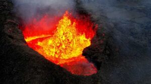
Drone imagery of April 2024 eruption at Sundhnúkur, Iceland. Photo: Geoffrey Cook/Scripps Oceanography

Scientists often seek answers to humanity’s most pressing challenges in nature. When it comes to global warming, geological history offers a unique, long-term perspective. Earth’s geological history is spiked by periods of catastrophic volcanic eruptions that released vast amounts of carbon into the atmosphere and oceans. The increased carbon triggered rapid climate warming that resulted in mass extinctions on land and in marine ecosystems. These periods of volcanism may also have disrupted carbon-climate regulation systems for millions of years.

Ecological imbalance

Earth and environmental scientists at ETH Zurich led an international team of researchers from the University of Arizona, University of Leeds, CNRS Toulouse, and the Swiss Federal Institute for Forest Snow and Landscape Research (WSL) in a study on how vegetation responds and evolves in response to major climatic shifts and how such shifts affect Earth’s natural carbon-climate regulation system.

Drawing on geochemical analyses of isotopes in sediments, the research team compared the data with a specially designed model, which included a representation of vegetation and its role in regulating the geological climate system.

They used the model to test how the Earth system responds to the intense release of carbon from volcanic activity in different scenarios.

They studied three significant climatic shifts in geological history, including the Siberian Traps event that caused the Permian-Triassic mass extinction about 252 million years ago.

ETH Zurich professor, Taras Gerya points out, “The Siberian Traps event released some 40,000 gigatons (Gt) of carbon over 200,000 years. The resulting increase in global average temperatures between 5 — 10°C caused Earth’s most severe extinction event in the geologic record.”

Move, adapt, or perish

“The recovery of vegetation from the Siberian Traps event took several millions of years and during this time Earth’s carbon-climate regulation system would have been weak and inefficient resulting in long-term climate warming,” explains lead author, Julian Rogger, ETH Zurich.

Researchers found that the severity of such events is determined by how fast emitted carbon can be returned to Earth’s interior — sequestered through silicate mineral weathering or organic carbon production, removing carbon from Earth’s atmosphere.

They also found that the time it takes for the climate to reach a new state of equilibrium depended on how fast vegetation adapted to increasing temperatures.

Some species adapted by evolving and others by migrating geographically to cooler regions.

However, some geological events were so catastrophic that plant species simply did not have enough time to migrate or adapt to the sustained increase in temperature.

The consequences of which left its geochemical mark on climate evolution for thousands, possibly millions, of years.

Today’s human-induced climate crisis

What does this mean for human induced climate change? The study found that a disruption of vegetation increased the duration and severity of climate warming in the geologic past.

In some cases, it may have taken millions of years to reach a new stable climatic equilibrium due to a reduced capacity of vegetation to regulate Earth’s carbon cycle.

“Today, we find ourselves in a major global bioclimatic crisis,” comments Loïc Pellissier, Professor of Ecosystems and Landscape Evolution at ETH Zurich and WSL. “Our study demonstrates the role of a functioning of vegetation to recover from abrupt climatic changes. We are currently releasing greenhouse gases at a faster rate than any previous volcanic event. We are also the primary cause of global deforestation, which strongly reduces the ability of natural ecosystems to regulate the climate. This study, in my perspective, serves as ‘wake-up call’ for the global community.”

Reference:
Julian Rogger, Emily J. Judd, Benjamin J. W. Mills, Yves Goddéris, Taras V. Gerya, Loïc Pellissier. Biogeographic climate sensitivity controls Earth system response to large igneous province carbon degassing. Science, 2024; 385 (6709): 661 DOI: 10.1126/science.adn3450

Note: The above post is reprinted from materials provided by ETH Zurich. Original written by Marianne Lucien.

Fossil shows how penguins’ wings evolved

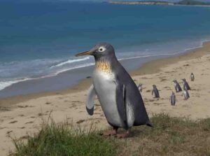
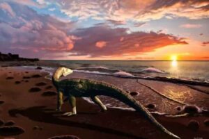
A reconstructed image of Pakudyptes at a New Zealand coast. PHOTO: Tatsuya Shinmura & Ashoro Museum of Paleontology

A tiny fossil penguin plays a huge role in the evolutionary history of the bird, an international study shows.

Published in the Journal of the Royal Society of New Zealand, the study describes a new species of fossil penguin which lived in Otago about 24 million years ago.

Named Pakudyptes hakataramea, the penguin was very small — about the same size as the little blue penguin, the smallest in the world — with anatomical adaptations that allowed it to dive.

Lead author Dr Tatsuro Ando, formerly a PhD candidate at the University of Otago — Ōtākou Whakaihu Waka and now at the Ashoro Museum of Palentology in Japan, collaborated with researchers from Otago, Okayama University of Science and Osaka University.

Dr Ando’s inspiration for the paper came from discussions with the late Professor Ewan Fordyce, his supervisor and mentor at Otago.

Researchers analysed three bones — a humerus, femur and ulna — found by Professor Fordyce in the Hakataramea Valley, South Canterbury.

Dr Ando says Pakudyptes fills a morphological gap between modern and fossil penguins.

“In particular, the shape of the wing bones differed greatly, and the process by which penguin wings came to have their present form and function remained unclear,” he says.

The humerus and ulna highlight how penguins’ wings have evolved.

“Surprisingly, while the shoulder joints of the wing of Pakudyptes were very close to the condition of the present-day penguin, the elbow joints were very similar to those of older types of fossil penguins.

“Pakudyptes is the first fossil penguin ever found with this combination, and it is the ‘key’ fossil to unlocking the evolution of penguin wings.”

Co-author Dr Carolina Loch, from Otago’s Faculty of Dentistry, says analysis of the internal bone structure conducted at the Faculty of Dentistry, with comparison with data on living penguins provided from the Okayama University of Science, shows these penguins had microanatomical features suggestive of diving.

Modern penguins have excellent swimming abilities, largely due to their dense, thick bones that contribute to buoyancy during diving.

In Pakudyptes, the bone cortex was reasonably thick although the medullary cavity, which contains bone marrow, was open, similar to what we see in the modern little blue penguin, which tends to swim in shallow waters.

The ability for Pakudyptes to dive and swim comes down to the distinctive combination of its bones.

Bones such as the humerus and ulna show areas for attachment of muscles and ligaments which reveal how the wings were being used to swim and manoeuvre under water.

Dr Loch says fossil penguins were usually large, about 1m in height.

“Penguins evolved rapidly from the Late Oligocene to Early Miocene and Pakudyptes is an important fossil from this period. Its small size and unique combination of bones may have contributed to the ecological diversity of modern penguins.”

Reference:
Tatsuro Ando, Jeffrey Robinson, Carolina Loch, Tamon Nakahara, Shoji Hayashi, Marcus D. Richards, Robert Ewan Fordyce. A new tiny fossil penguin from the Late Oligocene of New Zealand and the morphofunctional transition of the penguin wing. Journal of the Royal Society of New Zealand, 2024; 1 DOI: 10.1080/03036758.2024.2362283

Note: The above post is reprinted from materials provided by University of Otago.

Scientists assess how large dinosaurs could really get

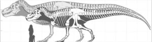
Skeleton of the largest-known T. rex (foreground) and silhouette of the largest possible giant T. rex. Credit: Mark Witton.

A new study published today in the scientific journal Ecology and Evoiution looks at the maximum possible sizes of dinosaurs, using the carnivore, Tyrannosaurus rex, as an example. Using computer modelling, Dr. Jordan Mallon of the Canadian Museum of Nature and Dr. David Hone of Queen Mary University of London, produced estimates that T. Rex might have been 70% heavier than what the fossil evidence suggests.

The researchers assert that the huge sizes attained by many dinosaurs make them a source of endless fascination, raising the question as to how these animals evolved to be so big. There are perennial claims and counter-claims about which dinosaur species was the largest of its group or even the largest ever.

Most dinosaur species are known from only one or a handful of specimens, so it’s extraordinarily unlikely that their size ranges will include the largest individuals that ever existed. The question remains: how big were the largest individuals, and are we likely to find them?

To address this question, Mallon and Hone used computer modelling to assess a population of T. rex. They factored in variables such as population size, growth rate, lifespan, the incompleteness of the fossil record, and more.

T. rex was chosen for the model because it is a familiar dinosaur for which many of these details are already well estimated. Body-size variance at adulthood, which is still poorly known in T. rex, was modelled with and without sex differences, and is based on examples of living alligators, chosen for their large size and close kinship with the dinosaurs.

The palaeontologists found that the largest known T. rex fossils probably fall in the 99th percentile, representing the top 1% of body size, but to find an animal in the top 99.99% (a one-in-ten-thousand individual) scientists would need to excavate fossils at the current rate for another 1,000 years.

The computer models suggest that the largest individual that could have existed (one in 2.5 billion animals) may have been 70% more massive than the current largest-known T. rex specimens (an estimated 15 tonnes vs 8.8 tonnes) and 25% longer (15 metres vs 12 metres).

The values are estimates based on the model, but patterns of discovery of giants of modern species tell us there must have been larger dinosaurs out there that have not yet been found. “Some isolated bones and pieces certainly hint at still larger individuals than for which we currently have skeletons,” says Hone.

This study adds to the debates about the largest fossil animals. Many of the largest dinosaurs in various groups are known from a single good specimen, so it’s impossible to know if that one animal was a big or small example of the species. An apparently large species might be based on a single giant individual, and a small species based on a particularly tiny individual — neither of which reflect the average size of their respective species.

The chances that palaeontologists will find the largest ever individuals for a given species are incredibly small. So, despite the giant skeletons that can be seen in museums around the world, the very largest individuals of these species were likely even larger than those on display.

Dr. Jordan Mallon, from the Canadian Museum of Nature, said: “Our study suggests that, for big fossil animals like T. rex, we really have no idea from the fossil record about the absolute sizes they might have reached. It’s fun to think about a 15 tonne T. rex, but the implications are also interesting from a biomechanical or ecological perspective.”

Reference:
Jordan C. Mallon, David W. E. Hone. Estimation of maximum body size in fossil species: A case study using Tyrannosaurus rex. Ecology and Evolution, 2024; 14 (7) DOI: 10.1002/ece3.11658

Note: The above post is reprinted from materials provided by Canadian Museum of Nature.

Research tracks 66 million years of mammalian diversity

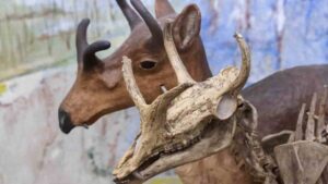
The Syndyoceras existed for 4.2 million years during the Cenozoic era on the North American continent. This skeletal display can be found in the University of Nebraska State Museum–Morill Hall.

When trying to understand the present, it’s helpful to look to history. New research from the University of Nebraska-Lincoln examined the fossil record going back 66 million years and tracked changes to mammalian ecosystems and species diversity on the North American continent.

The study, led by Alex Shupinski, who earned her doctorate in May, and co-authored by Kate Lyons, associate professor in the School of Biological Sciences, provides a large-scale view of how species diversity changed over the first 65 million years of the Cenozoic era — up until the arrival of humans — and how climate and other environmental factors, including changing landscapes, affected animal life on the continent.

The findings published in Proceedings of the Royal Society B also provide a glimpse into how mammals rebounded following the last mass extinction event — the eradication of non-avian dinosaurs.

“Beginning 66 million years ago, we go from a completely sub-tropical environment across North America to grasslands to a frozen savanna, and finally, reaching the Ice Age,” Shupinski said. “It’s showing how species changed through time, through many ecological, environmental and climatic changes and it allows us to compare across those events and at different spatial scales.”

The researchers sliced the fossil record of the Cenozoic era into million-year increments and used three indices of functional diversity — which quantifies changes in community structures using mammalian traits — to examine mammalian communities on both a local and continental scale.

For most of the Cenozoic era, local and continental measures of functional diversity differed, but surprisingly, during the first 10 million years of the era, immediately following the extinction of non-avian dinosaurs, all measures of functional diversity, both locally and across the continent, increased.

“That was fascinating to see, that for most of the Cenozoic, functional diversity was uncoupled across time and spatial scales, except this one time,” Shupinski said. “For 10 million years, all the measures are changing in the same way. Then, around 56 million years ago, we get this massive immigration of mammals into North America from other continents, and at that point, we see a divergence of functional diversity.

“Communities are changing at different times, at different rates and in different directions,” she said. “We might see locally, the diversity of roles increasing, but continentally, they’re decreasing.”

Lyons said that some of the changes among mammalian species can be explained by environmental changes, including cooling and warming periods or when heavily forested areas were usurped by grasslands, but that the large-scale environmental changes did not rise to the level of disruption caused by the mass extinction of dinosaurs.

“That is why this could potentially be a way to pinpoint areas of the globe or communities that are under particular stress,” Lyons said. “We may be entering a sixth mass extinction event, and if so, we might expect to see communities that are on the vanguard of that extinction respond in a similar way, based on the patterns we see after the extinction of the non-avian dinosaurs.”

In the field of conservation paleobiology, tracking past changes in ecosystems over long periods of time helps scientists and the public better understand biodiversity crises happening today, and this current study offers a thorough analysis of the age of mammals and hints at what may come next.

“If we are looking at the modern (crises) and we see a similar response in the functional diversity of modern community structures, it may be a conservation tool as we can highlight some of these communities that are experiencing the most disturbance and that are at highest risk of change and disturbance in their ecological services and function,” Shupinski said.

Additional authors on the study are Peter Wagner, professor of Earth and atmospheric sciences at Nebraska, and Felisa Smith of the University of New Mexico, Albuquerque.

Reference:
Alex B. Shupinski, Peter J. Wagner, Felisa A. Smith, S. Kathleen Lyons. Unique functional diversity during early Cenozoic mammal radiation of North America. Proceedings of the Royal Society B: Biological Sciences, 2024; 291 (2026) DOI: 10.1098/rspb.2024.0778

Note: The above post is reprinted from materials provided by University of Nebraska-Lincoln. Original written by Deann Gayman.

Komodo dragons have iron-coated teeth to rip apart their prey

Komodo dragon. Credit: Charlotte Ellis, Zoological Society of London

Scientists have discovered that the serrated edges of Komodo dragons’ teeth are tipped with iron.

Led by researchers from King’s College London, the study gives new insight into how Komodo dragons keep their teeth razor-sharp and may provide clues to how dinosaurs like Tyrannosaurus rex killed and ate their prey.

Native to Indonesia, Komodo dragons are the largest living species of monitor lizard, averaging around 80kg. Deadly predators, Komodos have sharp, curved teeth similar to many carnivorous dinosaurs. They eat almost any kind of meat, from smaller reptiles and birds to deer, horses or water buffalo, pulling and tearing at their prey to rip flesh apart.

The researchers discovered that many reptiles have some iron in their teeth, but Komodo dragons have concentrated the iron along the cutting edges and tips of their teeth, staining them orange. Crocodiles and other monitor lizards, by comparison, have so little that the iron is often invisible.

To understand the chemical and structural make-up of Komodo dragon’s teeth, scientists scoured museums for skulls and teeth of Komodo dragons and studied the teeth of Ganas, the 15-year-old Komodo dragon who had lived at ZSL conservation zoo, London Zoo.

Through advanced imaging and chemical analysis, the team was able to observe that the iron in Komodo dragons’ enamel is concentrated into a thin coating on top of their tooth serrations and tips. This protective layer keeps the serrated edges of their teeth sharp and ready to be used at a moment’s notice.

The research, published today in Nature Ecology & Evolution, leads to new questions and avenues for research into how extinct species such as dinosaurs lived and ate.

Dr Aaron LeBlanc, lecturer in Dental Biosciences at King’s College London and the study’s lead author said: “Komodo dragons have curved, serrated teeth to rip and tear their prey just like those of meat-eating dinosaurs. We want to use this similarity to learn more about how carnivorous dinosaurs might have ate and if they used iron in their teeth the same way as the Komodo dragon.

“Unfortunately, using the technology we have at the moment, we can’t see whether fossilised dinosaur teeth had high levels of iron or not. We think that the chemical changes which take place during the fossilisation process obscure how much iron was present to start with.

“What we did find, though, was that larger meat-eating dinosaurs, like tyrannosaurs, did change the structure of the enamel itself on the cutting edges of their teeth. So, while Komodo dragons have altered the chemistry of their teeth, some dinosaurs altered the structure of their dental enamel to maintain a sharp cutting edge.

“With further analysis of the Komodo teeth we may be able to find other markers in the iron coating that aren’t changed during fossilisation. With markers like that we would know with certainty whether dinosaurs also had iron-coated teeth and have a greater understanding of these ferocious predators.”

Dr Benjamin Tapley, Curator of Reptiles and Amphibians at ZSL and co-author on the study said: “As the world’s largest lizards, Komodo dragons are inarguably impressive animals. Having worked with them for 12 years at London Zoo, I continue to be fascinated by them and these findings further emphasise just how incredible they are.

“Komodo dragons are sadly endangered, so in addition to strengthening our understanding of how iconic dinosaurs might have lived, this discovery also helps us build a deeper understanding of these amazing reptiles as we work to protect them.”

Reference:
Aaron R. H. LeBlanc, Alexander P. Morrell, Slobodan Sirovica, Maisoon Al-Jawad, David Labonte, Domenic C. D’Amore, Christofer Clemente, Siyang Wang, Finn Giuliani, Catriona M. McGilvery, Michael Pittman, Thomas G. Kaye, Colin Stevenson, Joe Capon, Benjamin Tapley, Simon Spiro, Owen Addison. Iron-coated Komodo dragon teeth and the complex dental enamel of carnivorous reptiles. Nature Ecology & Evolution, 2024; DOI: 10.1038/s41559-024-02477-7

Note: The above post is reprinted from materials provided by King’s College London.

A new species of extinct crocodile relative rewrites life on the Triassic coastline

Benggwigwishingasuchus eremicarminis on the Panthalassan Ocean coast artwork by Jorge Gonzalez
Benggwigwishingasuchus eremicarminis on the Panthalassan Ocean coast
artwork by Jorge Gonzalez

The surprising discovery of a new species of extinct crocodile relative from the Triassic Favret Formation of Nevada, USA, rewrites the story of life along the coasts during the first act of the Age of Dinosaurs. Described in a study published in Biology Letters, the new species Benggwigwishingasuchus eremicarminis reveals that while giant ichthyosaurs ruled the oceans, the ancient crocodile kin known as pseudosuchian archosaurs ruled the shores across the Middle Triassic globe between 247.2 and 237 million years ago.

“This exciting new species demonstrates that pseudosuchians were occupying coastal habitats on a global basis during the Middle Triassic,” said Dr. Nate Smith, lead author of the paper, and Gretchen Augustyn Director and Curator of the Dinosaur Institute at the Natural History Museum of Los Angeles County.

Capturing fossil life from the eastern Panthalassan Ocean of the Triassic, the locality that includes the Favret Formation is known for fossils of sea-going creatures like ammonites along with marine reptiles like the giant ichthyosaur C. youngorum — finding the newly described B. eremicarminis came as a bit of a shock.

“Our first reaction was: What the hell is this?” said co-author Dr. Nicole Klein of the University of Bonn. “We were expecting to find things like marine reptiles. We couldn’t understand how a terrestrial animal could end up so far out in the sea among the ichthyosaurs and ammonites. It wasn’t until seeing the nearly completely prepared specimen in person that I was convinced it really was a terrestrial animal.”

Pseudosuchian archosaurs have been unearthed in fossil beds from the shores of the ancient Tethys Ocean, but this is the first coastal representative from the Panthalassan Ocean and western hemisphere, revealing that these crocodile relatives were present in coastal environments worldwide during the Middle Triassic. Interestingly, these coastal species aren’t all from the same evolutionary group, suggesting that pseudosuchians (and archosauriforms more broadly) were independently adapting to life along the shores.

“Essentially, it looks like you had a bunch of very different archosauriform groups deciding to dip their toes in the water during the Middle Triassic. What’s interesting, is that it doesn’t look like many of these ‘independent experiments’ led to broader radiations of semi-aquatic groups,” said Smith.

During the Triassic, archosaurs, “the ruling reptiles,” arose and split into two groups with two surviving representatives: birds, the descendants of dinosaurs, and crocodilians (alligators, crocodiles, and gharials), the descendants of pseudosuchian archosaurs like B. eremicarminis. While today’s crocodilians are similar enough to be mistaken for one another by most people, their ancient relatives varied wildly in size and lifestyle. The evolutionary relationships of B. eremicarminis and its relatives suggest that pseudosuchians achieved great diversity very quickly following the End-Permian mass extinction — the extent of which is waiting to be discovered in the fossil record.

“A growing number of recent discoveries of Middle Triassic pseudosuchians are hinting that an underappreciated amount of morphological and ecological diversity and experimentation was happening early in the group’s history. While a lot of the public’s fascination with the Triassic focuses on the origin of dinosaurs, it’s really the pseudosuchians that were doing interesting things at the beginning of the Mesozoic,” Smith said.

The new species underlines the multiplicity of these ancient reptiles during the Triassic, from giants like Mambawakale ruhuhu to smaller animals like the newly described B. eremicarminis, which probably reached around 5-6 feet in length. Exactly how long B. eremicarminis was and how it survived along the coasts remains shrouded in the past. Only a few elements of the individual’s skull were found, and any clues to how it fed and hunted are similarly absent. What’s more clear is that B. eremicarminis likely stuck pretty close to the shore. Its well-preserved limbs are well-developed without any of the signs of aquatic living like flippers or altered bone density.

The research team wanted a name that paid respect to the original human inhabitants of the Augusta Mountains where the specimen was found, and so consulted a member of the Fallon Paiute Shoshone Tribe to decide on an appropriate name.”Benggwi-Gwishinga,” a word that means “catching fish” in Shoshone, was combined with the Greek word for Sobek, the Egyptian crocodile-headed god, to coin the new genus, Benggwigwishingasuchus. The specific epithet eremicarminis translates to “desert song,” honoring two supporters of NHMLAC who have a passion for the paleontology and opera of the Southwest. Thus, the full name is meant to translate roughly as “Fisherman Croc’s Desert Song.”

Reference:
Nathan D. Smith, Nicole Klein, P. Martin Sander, Lars Schmitz. A new pseudosuchian from the Favret Formation of Nevada reveals that archosauriforms occupied coastal regions globally during the Middle Triassic. Biology Letters, 2024; 20 (7) DOI: 10.1098/rsbl.2024.0136

Note: The above post is reprinted from materials provided by Natural History Museum of Los Angeles County.

New model refutes leading theory on how Earth’s continents formed

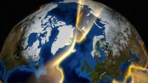
Continental plates around Greenland.
This is a visualization of the continental plates around Greenland. Credit: NASA’s Goddard Space Flight Center

The formation of Earth’s continents billions of years ago set the stage for life to thrive. But scientists disagree over how those land masses formed and if it was through geological processes we still see today.

A recent paper from the University of Illinois Chicago’s David Hernández Uribe in Nature Geoscience adds new information to that debate, poking holes in the leading theory of continent formation.

Hernández Uribe used computer models to study the formation of magmas thought to hold clues to the origin of continents.

Magma is the molten substance that, when it cools, forms rocks and minerals.

Hernández Uribe looked for magmas that match the compositional signature of rare mineral deposits called zircons that date back to the Archaean period of 2.5 to 4 billion years ago, when scientists believed that continents first formed.

Last year, scientists from China and Australia published a paper arguing that Archaean zircons could only be formed by subduction — when two tectonic plates collide underwater, pushing land mass to the surface.

That process still happens today, causing earthquakes and volcanic eruptions and reshaping the coasts of continents.

But Hernández Uribe, assistant professor of earth and environmental sciences, found that subduction was not necessary to create Archaean zircons.

Instead, he found that the minerals could form through high pressure and temperatures associated with the melting of the Earth’s thick primordial crust.

“Using my calculations and models, you can get the same signatures for zircons and even provide a better match through the partial melting of the bottom of the crust,” Hernández Uribe said.

“So based on these results, we still do not have enough evidence to say which process formed the continents.”

The results also raise uncertainty about when plate tectonics started on Earth.

If Earth’s first continents formed by subduction, that meant that continents started moving between 3.6 to 4 billion years ago — as little as 500 million years into the planet’s existence.

But the alternative theory of melting crust forming the first continents means that subduction and tectonics could have started much later.

“Our planet is the only planet in the solar system that has active plate tectonics as we know it,” Hernández Uribe said. “And this relates to the origin of life, because how the first continents moved controlled the weather, it controlled the chemistry of the oceans, and all that is related to life.”

Reference:
David Hernández-Uribe. Generation of Archaean oxidizing and wet magmas from mafic crustal overthickening. Nature Geoscience, 2024; DOI: 10.1038/s41561-024-01489-z

Note: The above post is reprinted from materials provided by University of Illinois Chicago.

Greenland fossil discovery reveals increased risk of sea-level catastrophe

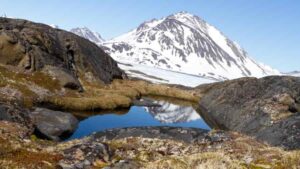
A rocky landscape with tundra plants near the eastern coast of Greenland, similar to what the interior of the island may have looked like when its massive ice sheet melted away. (Photo: Joshua Brown)

The story of Greenland keeps getting greener — and scarier.

A new studyprovides the first direct evidence that the center — not just the edges — of Greenland’s ice sheet melted away in the recent geological past and the now-ice-covered island was then home to a green, tundra landscape.

A team of scientists re-examined a few inches of sediment from the bottom of a two-mile-deep ice core extracted at the very center of Greenland in 1993 — and held for 30 years in a Colorado storage facility. They were amazed to discover soil that contained willow wood, insect parts, fungi, and a poppy seed in pristine condition.

“These fossils are beautiful,” says Paul Bierman, a scientist at the University of Vermont who co-led the new study with UVM graduate student Halley Mastro and nine other researchers, “but, yes, we go from bad to worse,” in what this implies about the impact of human-caused climate change on the melting of the Greenland ice sheet.

The study, published in the Proceedings of the National Academy of Sciences on August 5th, confirms that Greenland’s ice melted and the island greened during a prior warm period likely within the last million years — suggesting that the giant ice sheet is more fragile than scientists had realized until the last few years.

If the ice covering the center of the island was melted, then most of the rest of it had to be melted too. “And probably for many thousands of years,” Bierman said, enough time for soil to form and an ecosystem to take root.

“This new study confirms and extends that a lot of sea-level rise occurred at a time when causes of warming were not especially extreme,” said Richard Alley, a leading climate scientist at Penn State who reviewed the new research, “providing a warning of what damages we might cause if we continue to warm the climate.”

Sea level today is rising more than an inch each decade. “And it’s getting faster and faster,” said Bierman. It is likely to be several feet higher by the end of this century, when today’s children are grandparents. And if the release of greenhouse gases — from burning fossil fuels — is not radically reduced, he said, the near complete melting of Greenland’s ice over the next centuries to a few millennia would lead to some 23 feet of sea level rise.

“Look at Boston, New York, Miami, Mumbai or pick your coastal city around the world, and add twenty plus feet of sea level,” said Bierman. “It goes underwater. Don’t buy a beach house.”

Core Assumptions

In 2016, Joerg Schaefer at Columbia University and colleagues tested rock from the bottom of the same 1993 ice core (called GISP2) and published a then-controversial study suggesting that the current Greenland ice sheet could be no more than 1.1 million years old; that there were extended ice-free periods during the Pleistocene (the geological period that began 2.7 million years ago); and that if the ice was melted at the GISP2 site then 90% of the rest of Greenland would be melted also. This was a major step toward overturning the longstanding story that Greenland is an implacable fortress of ice, frozen solid for millions of years.

Then, in 2019, UVM’s Paul Bierman and an international team reexamined another ice core, this one extracted at Camp Century near the coast of Greenland in the 1960s. They were stunned to discover twigs, seeds, and insect parts at the bottom of that core — revealing that the ice there had melted within the last 416,000 years. In other words, the walls of the ice fortress had failed much more recently than had been previously imagined possible.

“Once we made the discovery at Camp Century, we thought, ‘Hey, what’s at the bottom of GISP2?'” said Bierman, a professor in UVM’s Rubenstein School of Environment and Natural Resources and fellow in the Gund Institute for Environment. Though the ice and rock in that core had been studied extensively, “no one’s looked at the 3 inches of till to see if it’s soil and if it contains plant or insect remains,” he said. So he and his colleagues requested a sample from the bottom of the GISP2 core held at the National Science Foundation Ice Core Facility in Lakewood, Colorado.

Now this new study in PNAS, with support from the U.S. National Science Foundation, provides confirmation that the 2016 “fragile Greenland” hypothesis is right. And it deepens the reasons for concern, showing that the island was warm enough, for long enough, that an entire tundra ecosystem, perhaps with stunted trees, established itself where today ice is two miles deep.

“We now have direct evidence that not only was the ice gone, but that plants and insects were living there,” said Bierman. “And that’s unassailable. You don’t have to rely on calculations or models.”

From Flowers

The initial discovery that there was intact biological material — not just gravel and rock — in the bottom of the ice core was made by geoscientist Andrew Christ who completed his PhD working at UVM and was a post-doctoral associate in Bierman’s lab. Then Halley Mastro picked up the case and began to study the material closely.

“It was amazing,” she said. Under the microscope, what had looked like no more than specks floating on the surface of the melted core sample, was, in fact, a window into a tundra landscape. Working with Dorothy Peteet, an expert on macrofossils at the Lamont-Doherty Earth Observatory and co-author on the new study, Mastro was able to identify spores from spikemoss, the bud scale of a young willow, the compound eye of an insect, “and then we found Arctic poppy, just one seed of that,” she said. “That is a tiny flower that’s really good at adapting to the cold.”

But not that good. “It lets us know that Greenland’s ice melted and there was soil,” said Mastro, “because poppies don’t grow on top of miles of ice.”

Reference:
Paul R. Bierman, Halley M. Mastro, Dorothy M. Peteet, Lee B. Corbett, Eric J. Steig, Chris T. Halsted, Marc M. Caffee, Alan J. Hidy, Greg Balco, Ole Bennike, Barry Rock. Plant, insect, and fungi fossils under the center of Greenland’s ice sheet are evidence of ice-free times. Proceedings of the National Academy of Sciences, 2024; 121 (33) DOI: 10.1073/pnas.2407465121

Note: The above post is reprinted from materials provided by University of Vermont. Original written by Joshua Brown.

Research reveals the most complete dinosaur discovered in the UK in a century

An artist’s impression of the dinosaur. Image credit: John Sibbick

The most complete dinosaur discovered in this country in the last 100 years, with a pubic hip bone the size of a ‘dinner plate’, has been described in a new paper published today.

The specimen, which is around 125 million years old, was found in the cliffs of Compton Bay on the Isle of Wight in 2013 by fossil collector Nick Chase, before he tragically died of cancer.

Jeremy Lockwood, a retired GP and University of Portsmouth PhD student, helped with the dinosaur’s excavation and has spent years analysing the 149 different bones that make up the skeleton.

Jeremy determined that the skeleton represented a new genus and species, which he named Comptonatus chasei in tribute to Nick.

Jeremy said: “Nick had a phenomenal nose for finding dinosaur bones — he really was a modern-day Mary Anning. He collected fossils daily in all weathers and donated them to museums. I was hoping we’d spend our dotage collecting together as we were of similar ages, but sadly that wasn’t to be the case.

“Despite his many wonderful discoveries over the years, including the most complete Iguanodon skull ever found in Britain, this is the first dinosaur to be named after him.”

When it was first discovered, the specimen was thought to be a known dinosaur called Mantellisaurus, but Jeremy’s study revealed a lot more dinosaur diversity. Indeed, this is the second new genus to be described by Jeremy.

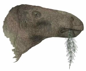
He said: “I’ve been able to show this dinosaur is different because of certain unique features in its skull, teeth and other parts of its body. For example its lower jaw has a straight bottom edge, whereas most iguanodontians have a jaw that curves downwards. It also has a very large pubic hip bone, which is much bigger than other similar dinosaurs. It’s like a dinner plate!”

Jeremy doesn’t know why the pubic hip bone, which is placed at the base of the abdomen was so big: “It was probably for muscle attachments, which might mean its mode of locomotion was a bit different, or it could have been to support the stomach contents more effectively, or even have been involved in how the animal breathed, but all of these theories are somewhat speculative.”

Jeremy named the dinosaur Comptonatus after Compton Bay where it was found and ‘tonatus’ is a latin word meaning ‘thunderous’.

“This animal would have been around a ton, about as big as a large male American bison. And evidence from fossil footprints found nearby shows it was likely to be a herding animal, so possibly large herds of these heavy dinosaurs may have been thundering around if spooked by predators on the floodplains over 120 million years ago.”

Dr Susannah Maidment, Senior Researcher and palaeontologist at the Natural History Museum and senior author of the paper completed whilst supervising Jeremy’s PhD, commented: “Comptonatus is a fantastic dinosaur specimen: one of the most complete to be found in the UK in a century.

“Its recognition as a new species is due to incredibly detailed work by NHM Scientific Associate Dr Jeremy Lockwood, whose research continues to reveal that the diversity of dinosaurs in southern England in the Early Cretaceous was much greater than previously realised.

“The specimen, which is younger than Brighstoneus but older than Mantellisaurus (two iguandontian dinosaurs closely related to Comptonatus) demonstrate fast rates of evolution in iguandontian dinosaurs during this time period, and could help us understand how ecosystems recovered after a putative extinction event at the end of the Jurassic Period.”

Despite only four new dinosaur species being described on the Isle of Wight in the whole of the 1900s, there have been eight new species named in the last five years.

Jeremy added: “This really is a remarkable find. It helps us understand more about the different types of dinosaurs that lived in England in the Early Cretaceous. This adds to recent research that shows that Wessex was one of the world’s most diverse ecosystems.”

The dinosaur has been added to the collections at the Dinosaur Isle Museum in Sandown on the Isle of Wight. The paper is published today in the Journal of Systematic Palaeontology.

Dr Martin Munt, Dinosaur Isle curator, said: “Ongoing research on the museum collection continues to reveal exciting new discoveries. Most of Nick’s most important finds have remained on the Island, a lasting legacy.

“We can look forward to many more new types of prehistoric creatures being discovered from the Island’s cliffs and collection.”

Mike Greenslade, General Manager for the National Trust on the Isle of Wight, said: “This extraordinary discovery at National Trust’s Compton Bay highlights the rich natural heritage of the Isle of Wight.

“Finding the most complete dinosaur in the UK in a century not only showcases the island’s palaeontological significance but also underscores the importance of preserving our landscapes for future generations to explore and learn from.

“Nick Chase’s remarkable find and Jeremy Lockwood’s dedicated research are a testament to the incredible history waiting to be uncovered here. We are thrilled to be part of this ongoing journey of discovery and scientific advancement.”

Reference:
Jeremy A. F. Lockwood, David M. Martill, Susannah C. R. Maidment. Comptonatus chasei , a new iguanodontian dinosaur from the Lower Cretaceous Wessex Formation of the Isle of Wight, southern England. Journal of Systematic Palaeontology, 2024; 22 (1) DOI: 10.1080/14772019.2024.2346573

Note: The above post is reprinted from materials provided by University of Portsmouth.

Life underground suited newly discovered dinosaur fine

Fona herzogae. Credit: Jorge Gonzales

The age of dinosaurs wasn’t conducted solely above ground. A newly discovered ancestor of Thescelosaurus shows evidence that these animals spent at least part of their time in underground burrows. The new species contributes to a fuller understanding of life during the mid-Cretaceous — both above and below ground.

The new dinosaur, Fona [/Foat’NAH/] herzogae lived 99 million years ago in what is now Utah. At that time, the area was a large floodplain ecosystem sandwiched between the shores of a massive inland ocean to the east and active volcanoes and mountains to the west. It was a warm, wet, muddy environment with numerous rivers running through it.

Paleontologists from North Carolina State University and the North Carolina Museum of Natural Sciences unearthed the fossil — and other specimens from the same species — in the Mussentuchit Member of the Cedar Mountain Formation, beginning in 2013. The preservation of these fossils, along with some distinguishing features, alerted them to the possibility of burrowing.

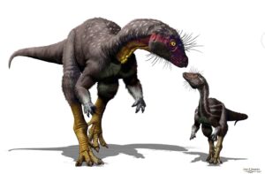
Fona was a small-bodied, plant-eating dinosaur about the size of a large dog with a simple body plan. It lacks the bells and whistles that characterize its highly ornamented relatives such as horned dinosaurs, armored dinosaurs, and crested dinosaurs. But that doesn’t mean Fona was boring.

Fona shares several anatomical features with animals known for digging or burrowing, such as large bicep muscles, strong muscle attachment points on the hips and legs, fused bones along the pelvis — likely to help with stability while digging — and hindlimbs that are proportionally larger than the forelimbs. But that isn’t the only evidence that this animal spent time underground.

“The bias in the fossil record is toward bigger animals, primarily because in floodplain environments like the Mussentuchit, small bones on the surface will often scatter, rot away, or become scavenged before burial and fossilization,” says Haviv Avrahami, Ph.D. student at NC State and digital technician for the new Dueling Dinosaurs program at the North Carolina Museum of Natural Sciences. Avrahami is first author of the paper describing the work.

“But Fona is often found complete, with many of its bones preserved in the original death pose, chest down with splayed forelimbs, and in exceptionally good condition,” Avrahami says. “If it had already been underground in a burrow before death, it would have made this type of preservation more likely.”

Lindsay Zanno, associate research professor at NC State, head of paleontology at the North Carolina Museum of Natural Sciences and corresponding author of the work, agrees.

“Fona skeletons are way more common in this area than we would predict for a small animal with fragile bones,” Zanno says. “The best explanation for why we find so many of them, and recover them in small bundles of multiple individuals, is that they were living at least part of the time underground. Essentially, Fona did the hard work for us, by burying itself all over this area.”

Although the researchers have yet to identify the subterranean burrows of Fona, the tunnels and chamber of its closest relative, Oryctodromeus, have been found in Idaho and Montana. These finds support the idea that Fona also used burrows.

The genus name Fona comes from the ancestral creation story of the Chamorro people, who are the indigenous populations of Guam and the Pacific Mariana Islands. Fo’na and Pontan were brother and sister explorers who discovered the island and became the land and sky. The species name honors Lisa Herzog, the paleontology operations manager at the North Carolina Museum of Natural Sciences, for her invaluable contributions and dedication to the field of paleontology.

“I wanted to honor the indigenous mythology of Guam, which is where my Chamorro ancestors are from,” Avrahami says. “In the myth, Fo’na became part of the land when she died, and from her body sprung forth new life, which to me, ties into fossilization, beauty, and creation. Fona was most likely covered in a downy coat of colorful feathers. The species name is for Lisa Herzog, who has been integral to all this work and discovered one of the most exceptional Fona specimens of several individuals preserved together in what was likely a burrow.”

Fona is also a distant relative of another famous North Carolina fossil: Willo, a Thescelosaurus neglectus specimen currently housed at the museum and also thought to have adaptations for a semifossorial — or partially underground — lifestyle, research that was published late in 2023 by Zanno and former NC State postdoctoral researcher David Button.

“T. neglectus was at the tail end of this lineage — Fona is its ancestor from about 35 million years prior,” Avrahami says.

The researchers believe Fona is key to expanding our understanding of Cretaceous ecosystems.

“Fona gives us insight into the third dimension an animal can occupy by moving underground,” says Avrahami. “It adds to the richness of the fossil record and expands the known diversity of small-bodied herbivores, which remain poorly understood despite being incredibly integral components of Cretaceous ecosystems.”

“People tend to have a myopic view of dinosaurs that hasn’t kept up with the science,” Zanno says. “We now know that dinosaur diversity ran the gamut from tiny arboreal gliders and nocturnal hunters, to sloth-like grazers, and yes, even subterranean shelterers.”

The work appears in The Anatomical Record. Peter Makovicky of the University of Minnesota and Ryan Tucker of Stellenbosch University also contributed to the work.

Reference:
Haviv M. Avrahami, Peter J. Makovicky, Ryan T. Tucker, Lindsay E. Zanno. A new semi‐fossorial thescelosaurine dinosaur from the Cenomanian‐age Mussentuchit Member of the Cedar Mountain Formation, Utah. The Anatomical Record, 2024; DOI: 10.1002/ar.25505

Note: The above post is reprinted from materials provided by North Carolina State University. Original written by Tracey Peake

Sixty-million-year-old grape seeds reveal how the death of the dinosaurs may have paved the way for grapes to spread

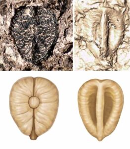
Lithouva - the earliest fossil grape from the Western Hemisphere, ~60 million years old from Colombia. Top figure shows fossil accompanied with CT scan reconstruction. Bottom shows artist reconstruction. Photos by Fabiany Herrera, art by Pollyanna von Knorring.
Lithouva – the earliest fossil grape from the Western Hemisphere, ~60 million years old from Colombia. Top figure shows fossil accompanied with CT scan reconstruction. Bottom shows artist reconstruction. Photos by Fabiany Herrera, art by Pollyanna von Knorring.

If you’ve ever snacked on raisins or enjoyed a glass of wine, you may, in part, have the extinction of the dinosaurs to thank for it. In a discovery described in the journal Nature Plants, researchers found fossil grape seeds that range from 60 to 19 million years old in Colombia, Panama, and Peru. One of these species represents the earliest known example of plants from the grape family in the Western Hemisphere. These fossil seeds help show how the grape family spread in the years following the death of the dinosaurs.

“These are the oldest grapes ever found in this part of the world, and they’re a few million years younger than the oldest ones ever found on the other side of the planet,” says Fabiany Herrera, an assistant curator of paleobotany at the Field Museum in Chicago’s Negaunee Integrative Research Center and the lead author of the Nature Plants paper. “This discovery is important because it shows that after the extinction of the dinosaurs, grapes really started to spread across the world.”

It’s rare for soft tissues like fruits to be preserved as fossils, so scientists’ understanding of ancient fruits often comes from the seeds, which are more likely to fossilize. The earliest known grape seed fossils were found in India and are 66 million years old. It’s not a coincidence that grapes appeared in the fossil record 66 million years ago-that’s around when a huge asteroid hit the Earth, triggering a massive extinction that altered the course of life on the planet. “We always think about the animals, the dinosaurs, because they were the biggest things to be affected, but the extinction event had a huge impact on plants too,” says Herrera. “The forest reset itself, in a way that changed the composition of the plants.”

Herrera and his colleagues hypothesize that the disappearance of the dinosaurs might have helped alter the forests. “Large animals, such as dinosaurs, are known to alter their surrounding ecosystems. We think that if there were large dinosaurs roaming through the forest, they were likely knocking down trees, effectively maintaining forests more open than they are today,” says Mónica Carvalho, a co-author of the paper and assistant curator at the University of Michigan’s Museum of Paleontology. But without large dinosaurs to prune them, some tropical forests, including those in South America, became more crowded, with layers of trees forming an understory and a canopy.

These new, dense forests provided an opportunity. “In the fossil record, we start to see more plants that use vines to climb up trees, like grapes, around this time,” says Herrera. The diversification of birds and mammals in the years following the mass extinction may have also aided grapes by spreading their seeds.

In 2013, Herrera’s PhD advisor and senior author of the new paper, Steven Manchester, published a paper describing the oldest known grape seed fossil, from India. While no fossil grapes had ever been found in South America, Herrera suspected that they might be there too.

“Grapes have an extensive fossil record that starts about 50 million years ago, so I wanted to discover one in South America, but it was like looking for a needle in a haystack,” says Herrera. “I’ve been looking for the oldest grape in the Western Hemisphere since I was an undergrad student.”

But in 2022, Herrera and his co-author Mónica Carvalho were conducting fieldwork in the Colombian Andes when a fossil caught Carvalho’s eye. “She looked at me and said, ‘Fabiany, a grape!’ And then I looked at it, I was like, ‘Oh my God.’ It was so exciting,” recalls Herrera. The fossil was in a 60-million-year-old rock, making it not only the first South American grape fossil, but among the world’s oldest grape fossils as well.

The fossil seed itself is tiny, but Herrera and Carvalho were able to identify it based on its particular shape, size, and other morphological features. Back in the lab, they conducted CT scans showing its internal structure that confirmed its identity. The team named the fossil Lithouva susmanii, “Susman’s stone grape,” in honor of Arthur T. Susman, a supporter of South American paleobotany at the Field Museum. “This new species is also important because it supports a South American origin of the group in which the common grape vine Vitis evolved,” says co-author Gregory Stull of the National Museum of Natural History.

The team conducted further fieldwork in South and Central America, and in the Nature Plants paper, Herrera and his co-authors ultimately described nine new species of fossil grapes from Colombia, Panama, and Perú, spanning from 60 to 19 million years old. These fossilized seeds not only tell the story of grapes’ spread across the Western Hemisphere, but also of the many extinctions and dispersals the grape family has undergone. The fossils are only distant relatives of the grapes native to the Western Hemisphere and a few, like the two species of Leea are only found in the Eastern Hemisphere today. Their places within the grape family tree indicate that their evolutionary journey has been a tumultuous one. “The fossil record tells us that grapes are a very resilient order. They’re a group that has suffered a lot of extinction in the Central and South American region, but they also managed to adapt and survive in other parts of the world,” says Herrera.

Given the mass extinction our planet is currently facing, Herrera says that studies like this one are valuable because they reveal patterns about how biodiversity crises play out. “But the other thing I like about these fossils is that these little tiny, humble seeds can tell us so much about the evolution of the forest,” says Herrera.

This study was authored by Fabiany Herrera (Field Museum), Mónica Carvalho (University of Michigan), Gregory Stull (National Museum of Natural History, Smithsonian Institution), Carlos Jarramillo (Smithsonian Tropical Research Institute), and Steven Manchester (Florida Museum of Natural History, University of Florida).

Reference:
Fabiany Herrera, Mónica R. Carvalho, Gregory W. Stull, Carlos Jaramillo, Steven R. Manchester. Cenozoic seeds of Vitaceae reveal a deep history of extinction and dispersal in the Neotropics. Nature Plants, 2024; DOI: 10.1038/s41477-024-01717-9

Note: The above post is reprinted from materials provided by Field Museum.

Newly discovered dinosaur boasts big, blade-like horns

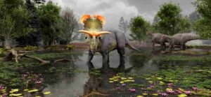
Reconstruction of Lokiceratops in the 78-million-year-old swamps of northern Montana, as two Probrachylophosaurus move past in the background. Artwork by Fabrizio Lavezzi © Evolutionsmuseet, Knuthenborg

What do you get when you cross Norse mythology with a 78-million-year-old ancestor to the Triceratops? Answer: Lokiceratops rangiformis, a plant-eating dinosaur with a very fancy set of horns.

The new dinosaur was identified and named by Colorado State University affiliate faculty member Joseph Sertich and University of Utah Professor Mark Loewen. The dinosaur’s name, announced today in the scientific journal PeerJ, translates roughly to “Loki’s horned face that looks like a caribou.”

Loewen and Sertich, co-lead authors of the PeerJ study, dubbed the new species Lokiceratops (lo-Kee-sare-a-tops) rangiformis because of the unusual, curving blade-like horns on the back of its frill — the shield of bone at the back of the skull — and the asymmetrical horns at the peak of the frill, reminiscent of caribou antlers.

“The dinosaur now has a permanent home in Denmark, so we went with a Norse god, and in the end, doesn’t it just really look like Loki with the curving blades?” Loewen said, referring to the trickster god’s weapon of choice.

Loewen, a paleontologist at the Natural History Museum of Utah, and Sertich, a paleontologist with the Smithsonian Tropical Research Institute, are both scientific consultants for the Museum of Evolution in Denmark, Lokiceratops’ new home.

“It’s one of those stories with a happy ending, where it didn’t go to somebody’s mansion,” Sertich said. “It ended up in a museum, where it will be preserved forever so people can study it and enjoy visiting it.”

New dinosaur discovery

Lokiceratops was discovered in 2019 in the badlands of northern Montana, two miles (3.2 kilometers) south of the U.S.-Canada border. Sertich and Loewen helped reconstruct the dinosaur from fragments the size of dinner plates and smaller. Once they had pieced the skull together, they realized the specimen was a new type of dinosaur.

Estimated to be 22 feet (6.7 meters) long and weigh 11,000 pounds (5 metric tonnes), Lokiceratops is the largest dinosaur from the group of horned dinosaurs called centrosaurines ever found in North America. It has the largest frill horns ever seen on a horned dinosaur and lacks the nose horn that is characteristic among its kin.

“This new dinosaur pushes the envelope on bizarre ceratopsian headgear, sporting the largest frill horns ever seen in a ceratopsian,” Sertich said in a press release announcing the dinosaur’s unveiling at the Natural History Museum of Utah, where a replica is displayed. “These skull ornaments are one of the keys to unlocking horned dinosaur diversity and demonstrate that evolutionary selection for showy displays contributed to the dizzying richness of Cretaceous ecosystems.”

Sertich likened dinosaur horns to feathers on birds. Birds use feather colors and patterns to differentiate their own species among other, similar species of birds.

“We think that the horns on these dinosaurs were analogous to what birds are doing with displays,” Sertich said. “They’re using them either for mate selection or species recognition.”

What Loki’s horns tell us about dinosaurs

Lokiceratops was excavated from the same rock layer as four other dinosaur species, indicating that five different dinosaurs lived side by side 78 million years ago in the swamps and coastal plains along the eastern shore of Laramidia, the western landmass of North America created when a seaway divided the continent. Three of these species were closely related but not found outside the region.

“It’s unheard-of diversity to find five living together, similar to what you would see on the plains of East Africa today with different horned ungulates,” Sertich said.

Unlike the broad range of large wild mammals that roam the U.S. West today, such as elk, these ancient animals were geographically limited, he added. Loki’s discovery provides evidence that these species evolved rapidly within a small area, a process sometimes seen in birds.

By the time Triceratops came onto the scene 12 million years later, regional differences had been homogenized into just two species of horned dinosaurs from Canada to Mexico — possibly in response to a more homogenous climate, Sertich said.

The study shows that dinosaur diversity has been underestimated and presents the most complete family tree of horned dinosaurs to date.

“Lokiceratops helps us understand that we only are scratching the surface when it comes to the diversity and relationships within the family tree of horned dinosaurs,” Loewen said.

Reference:
Mark A. Loewen, Joseph J. W. Sertich, Scott Sampson, Jingmai K. O’Connor, Savhannah Carpenter, Brock Sisson, Anna Øhlenschlæger, Andrew A. Farke, Peter J. Makovicky, Nick Longrich, David C. Evans. Lokiceratops rangiformis gen. et sp. nov. (Ceratopsidae: Centrosaurinae) from the Campanian Judith River Formation of Montana reveals rapid regional radiations and extreme endemism within centrosaurine dinosaurs. PeerJ, 2024; 12: e17224 DOI: 10.7717/peerj.17224

Note: The above post is reprinted from materials provided by Colorado State University. Original written by Jayme DeLoss.

Recent volcanic ‘fires’ in Iceland triggered by storage and melting in crust

Drone imagery of April 2024 eruption at Sundhnúkur, Iceland. Photo: Geoffrey Cook/Scripps Oceanography

Scientists from UC San Diego’s Scripps Institution of Oceanography have detected geochemical signatures of magma pooling and melting beneath the subsurface during the “Fagradalsfjall Fires,” that began on Iceland’s Reykjanes peninsula in 2021.

Continuous sampling of the erupted lavas from the Fagradalsfjall volcano enabled a detailed time-series analysis of geochemical signals. These show that the start of the eruption began with massive pooling of magma, contrasting initial hypothesis for magma ascent straight from the mantle.

Scripps Oceanography geologist James Day and his colleagues report on the analyses July 31 in the journal Nature.

“By collecting lavas in regular intervals, and then measuring their compositions in the laboratory, we can tell what’s feeding the volcano at depth,” said study lead Day. “It’s a bit like taking regular measurements of someone’s blood. In this case, the volcano’s ‘blood’ are the molten lavas that emanate so spectacularly from it.”

Day, students at Scripps Oceanography, and international colleagues have been studying basaltic lavas from other recent volcanic eruptions in addition to Iceland. These include the 2021 eruption of the Tajogaite volcano on the island of La Palma in the Canary Islands and the 2022 eruption of Mauna Loa in Hawai’i. They have found evidence for similar magma pooling beneath La Palma.

“What makes the Iceland eruption so remarkable is the huge signal of crust within the earliest lavas,” said Day. “Along with our studies from La Palma, it suggests crustal magma storage may be a common process involved in the run up to larger basaltic eruptions like those in Iceland or the Canary Islands. This information will be important for understanding volcanic hazard in the future,” he added, “as it may help to forecast volcanic activity.”

Previous studies had suggested that the Fagradalsfjall Fires erupted from the surface without interaction with the crust. Day’s team, including UC San Diego undergraduate student Savannah Kelly, used the isotopic composition of the element osmium to understand what was happening beneath the volcano.

“What’s useful about using osmium,” said Day, “is that one of its isotopes is produced by the radiogenic decay of another metal, rhenium. Because the elements behave differently during melting, one of the elements, rhenium, is enriched in Earth’s crust.” Day and colleagues took advantage of the distinct behaviors of rhenium and osmium to show that the early lavas from the Fagradalsfjall Fires were contaminated by crust.

Earth can be broken up into a series of layers. The deepest portion is the metallic core. The shallowest layers are the atmosphere, ocean, and the rocky crust. All human beings live on the crust, which is dominated by rock types such as granite or basalt like that found in Iceland’s lavas. In between the core and crust is the vast mantle of the Earth. This mantle layer is where melting occurs to produce the magmas feeding volcanoes like those in Iceland.

Previous works published on the recent volcanic eruptions on the Reykjanes Ridge had used other geochemical fingerprints to study the lavas. These fingerprints suggested only mantle contributions to the lavas. Osmium isotopes are highly sensitive to crust and enabled the unambiguous identification of its addition into the early lavas.

“The work began as undergraduate research experience for Savannah (Kelly) and we fully expected to see mantle signatures in the lavas throughout the eruption,” said Day. “You can imagine our astonishment when we were sitting in front of the mass spectrometer measuring the early samples and saw obvious signals of crust within them.”

The team analyzed lavas erupting from the Fagradalsfjall volcano in 2021 and in 2022. The 2021 lavas were contaminated by crust, the 2022 lavas were not. They conclude that the earliest lavas pooled in the crust and interaction with the crust may have helped trigger the eruption.

“After that, it appears that the magma of later eruptions used pre-existing pathways to get to the surface,” Day said.

Day and colleagues plan to continue their work on Iceland and other basaltic eruptions into the future. Previous eruptions on the Reykjanes peninsula have lasted for centuries.

“It seems that the volcanic ‘fires’ in Iceland will outlast me,” Day said. “The eruptions that are likely to continue there will provide a treasure trove of important scientific information on how volcanoes work and their associated hazards. Our study shows that the beginning of the eruption was not just visually spectacular, but was also geochemically so.”

Besides Day and Kelly, Geoffrey Cook of Scripps Oceanography, William Moreland and Thor Thordarsson from the University of Iceland, and Valentin Troll from Uppsala University in Sweden were involved in the research. The National Science Foundation (NSF) Petrology and Geochemistry program partly funded the research.

Reference:
James M. D. Day, Savannah Kelly, Valentin R. Troll, William M. Moreland, Geoffrey W. Cook, Thor Thordarson. Deep crustal assimilation during the 2021 Fagradalsfjall Fires, Iceland. Nature, 2024; DOI: 10.1038/s41586-024-07750-0

Note: The above post is reprinted from materials provided by University of California – San Diego. Original written by Robert Monroe

A blue miracle: How sapphires formed in volcanoes

A sapphire from sediment in the Kyll, a river in the western Eifel. The crystal measures approximately 0.9 mm in diameter. | © Sebastian Schmidt

Sapphires are among the most precious gems, yet they consist solely of chemically “contaminated” aluminum oxide, or corundum. Worldwide, these characteristically blue-colored crystals are mainly found in association with silicon-poor volcanic rocks. This connection is widely assumed to result from sapphires originating in deep crustal rocks and accidentally ending up on the Earth’s surface as magma ascended. Through geochemical analyses, geoscientists at Heidelberg University have shown that the millimeter-sized sapphire grains found in the Eifel (Germany) formed in association with volcanism.

The Eifel is a volcanic region in the center of Europe where magma from the Earth’s mantle has been penetrating the overlying crust for nearly 700,000 years. The melts are poor in silicon dioxide but rich in sodium and potassium. Magmas similar in composition worldwide are known for their abundance of sapphire. Why this extremely rare variant of corundum is frequently found in this type of volcanic deposit has been a mystery until now. “One explanation is that sapphire in the Earth’s crust originates from previously clayey sediments at very high temperatures and pressure and the ascending magmas simply form the elevator to the surface for the crystals,” explains Prof. Dr Axel Schmitt, a researcher at Curtin University in Perth (Australia) who is investigating isotope geology and petrology as an honorary professor at the Institute of Earth Sciences at Heidelberg University — his former home institution.

To test this assumption, the researchers examined a total of 223 sapphires from the Eifel. They found a portion of these millimeter-sized crystals in rock samples collected from volcanic deposits in the numerous quarries in the region. Most of the sapphires, however, come from river sediments. “Like gold, sapphire is very weathering-resistant compared to other minerals. Over protracted time periods, the grains are washed out of the rock and deposited in rivers. Because of their high density, they are easy to separate from lighter sediment components using a gold pan,” explains Sebastian Schmidt, who conducted the studies as part of his master’s degree at Heidelberg University.

The researchers determined the age of the sapphires from the Eifel using the uranium-lead method on mineral inclusions in the sapphire using a secondary ion mass spectrometer that could also identify the composition of oxygen isotopes. The different relative abundances of the light isotope O-16 and the heavy isotope O-18 provide information on the origin of the crystals like a fingerprint. Deep crustal rocks have more O-18 than melts from the Earth’s mantle. As the age determinations show, the sapphires in the Eifel formed at the same time as the volcanism. In part, they inherited the isotopic signature of the mantle melts, which were contaminated by heated and partially melted crustal rock at a depth of about five to seven kilometers. Other sapphires originated in contact with the subterranean melts, whereby melts permeated the adjacent rock and thus triggered sapphire formation. “In the Eifel, both magmatic and metamorphic processes, in which temperature changed the original rock, played a role in the crystallization of sapphire,” states Sebastian Schmidt.

The research results were published in the journal “Contributions to Mineralogy and Petrology.” Support for the work came from the Dr. Eduard Gübelin Association for Research and Identification of Precious Stones in Switzerland as well as the German Research Foundation.

Reference:

Sebastian Schmidt, Andreas Hertwig, Katharina Cionoiu, Christof Schäfer, Axel K. Schmitt. Petrologically controlled oxygen isotopic classification of cogenetic magmatic and metamorphic sapphire from Quaternary volcanic fields in the Eifel, Germany. Contributions to Mineralogy and Petrology, 2024; 179 (6) DOI: 10.1007/s00410-024-02136-x

Note: The above post is reprinted from materials provided by Heidelberg University.

New study supports stable mantle chemistry dating back to Earth’s early geologic history and over its prodigious evolution

A thin slice of the ancient rocks collected from Gakkel Ridge near the North Pole, photographed under a microscope and seen under cross-polarized light. Field width ~ 14mm.Credit: E. Cottrell, Smithsonian.
A thin slice of the ancient rocks collected from Gakkel Ridge near the North Pole, photographed under a microscope and seen under cross-polarized light. Field width ~ 14mm.
Credit: E. Cottrell, Smithsonian.

A new analysis of rocks thought to be at least 2.5 billion years old by researchers at the Smithsonian’s National Museum of Natural History helps clarify the chemical history of Earth’s mantle — the geologic layer beneath the planet’s crust. The findings hone scientists’ understanding of Earth’s earliest geologic processes, and they provide new evidence in a decades-long scientific debate about the geologic history of Earth. Specifically, the results provide evidence that the oxidation state of the vast majority of Earth’s mantle has remained stable through geologic time and has not undergone major transitions, contrary to what has been suggested previously by other researchers.

“This study tells us more about how this special place in which we live came to be the way it is, with its unique surface and interior that have allowed life and liquid water to exist,” said Elizabeth Cottrell, chair of the museum’s department of mineral sciences, curator of the National Rock Collection and co-author of the study. “It’s part of our story as humans because our origins all trace back to how Earth formed and how it has evolved.”

The study, published today in the journal Nature, centered on a group of rocks collected from the seafloor that possessed unusual geochemical properties. Namely, the rocks show evidence of having melted to an extreme degree with very low levels of oxidation; oxidation is when an atom or molecule loses one or more electrons in a chemical reaction. With the help of additional analyses and modeling, the researchers used the unique properties of these rocks to show that they likely date back to at least 2.5 billion years ago during the Archean Eon. Further, the findings show that the Earth’s mantle has overall retained a stable oxidation state since these rocks formed, in contrast to what other geologists have previously theorized.

“The ancient rocks we studied are 10,000 times less oxidized than typical modern mantle rocks, and we present evidence that this is because they melted deep in the Earth during the Archean, when the mantle was much hotter than it is today,” Cottrell said. “Other researchers have tried to explain the higher oxidation levels seen in rocks from today’s mantle by suggesting that an oxidation event or change has taken place between the Archean and today. Our evidence suggests that the difference in oxidation levels can simply be explained by the fact that Earth’s mantle has cooled over billions of years and is no longer hot enough to produce rocks with such low oxidation levels.”

The research team — including lead study author Suzanne Birner who completed a pre-doctoral fellowship at the National Museum of Natural History and is now an assistant professor at Berea College in Kentucky — began their investigation to understand the relationship between Earth’s solid mantle and modern seafloor volcanic rocks. The researchers started by studying a group of rocks that were dredged from the seafloor at two oceanic ridges where tectonic plates are spreading apart and the mantle is churning up to the surface and producing new crust.

The two places the studied rocks were collected from, the Gakkel Ridge near the North Pole and the Southwest Indian Ridge between Africa and Antarctica, are two of the slowest-spreading tectonic plate boundaries in the world. The slow pace of the spreading at these ocean ridges means that they are relatively quiet, volcanically speaking, compared to faster spreading ridges that are peppered with volcanoes such as the East Pacific Rise. This means that rocks collected from these slow-spreading ridges are more likely to be samples of the mantle itself.

When the team analyzed the mantle rocks they collected from these two ridges, they discovered they had strange chemical properties in common. First, the rocks had been melted to a much greater extent than is typical of Earth’s mantle today. Second, the rocks were much less oxidized than most other samples of Earth’s mantle.

To achieve such a high degree of melting, the researchers reasoned that the rocks must have melted deep in the Earth at very high temperatures. The only period of Earth’s geologic history known to include such high temperatures was between 2.5 and 4 billion years ago during the Archean Eon. Consequently, the researchers inferred that these mantle rocks may have melted during the Archean, when the inside of the planet was 360-540 degrees Fahrenheit (200-300 degrees Celsius) hotter than it is today.

Being so extremely melted would have protected these rocks from further melting that could have altered their chemical signature, allowing them to circulate in Earth’s mantle for billions of years without significantly changing their chemistry.

“This fact alone doesn’t prove anything,” Cottrell said. “But it opens the door to these samples being genuine geologic time capsules from the Archean.”

To explore the geochemical scenarios that might explain the low oxidation levels of the rocks collected at Gakkel Ridge and the Southwest Indian Ridge, the team applied multiple models to their measurements. The models revealed that the low oxidation levels they measured in their samples could have been caused by melting under extremely hot conditions deep in the Earth.

Both lines of evidence backed the interpretation that the rocks’ atypical properties represented a chemical signature from having melted deep in the Earth during the Archean, when the mantle could produce extremely high temperatures.

Previously, some geologists have interpreted mantle rocks with low oxidation levels as evidence that the Archean Earth’s mantle was less oxidized and that through some mechanism it has become more oxidized over time. Proposed oxidation mechanisms include a gradual increase in oxidation levels due to a loss of gasses to space, recycling of old seafloor by subduction and ongoing participation of Earth’s core in mantle geochemistry. But, to date, proponents of this view have not coalesced around any one explanation.

Instead, the new findings support the view that the oxidation level of Earth’s mantle has been largely steady for billions of years, and that the low oxidation seen in some samples of the mantle were created under geologic conditions the Earth can no longer produce because its mantle has since cooled. So, instead of some mechanism making Earth’s mantle more oxidized over billions of years, the new study argues that the high temperatures of the Archean made parts of the mantle less oxidized. Because Earth’s mantle has cooled since the Archean, it cannot produce rocks with super low oxidation levels anymore. Cottrell said the process of the planet’s mantle cooling provides a much simpler explanation: Earth simply does not make rocks like it used to.

Cottrell and her collaborators are now seeking to better understand the geochemical processes that shaped the Archean mantle rocks from the Gakkel Ridge and the Southwest Indian Ridge by simulating in the lab the extremely high pressures and temperatures found in the Archean.

This research contributes to the museum’s Our Unique Planet initiative. As a public-private research partnership, Our Unique Planet investigates what sets Earth apart from its cosmic neighbors by exploring the origins of the planet’s oceans and continents, as well as how minerals may have served as templates for life.

In addition to Birner and Cottrell, Fred Davis of the University of Minnesota Duluth and Jessica Warren of the University of Delaware were co-authors of the study.

The research was supported by the Smithsonian and the National Science Foundation.

Reference:

Suzanne K. Birner, Elizabeth Cottrell, Fred A. Davis, Jessica M. Warren. Deep, hot, ancient melting recorded by ultralow oxygen fugacity in peridotites. Nature, 2024; 631 (8022): 801 DOI: 10.1038/s41586-024-07603-w.

Note: The above post is reprinted from materials provided by Smithsonian.

Scientists discover missing piece in climate models

Photo-like satellite image of southern Greenland on the afternoon of September 4, 2022. Bare, dirty ice at the margin of the ice sheet appears gray. Snow-covered ice is bright white. Pale blue ribbons and circles are lakes, rivers and ponds of melt water. NASA image from Worldview

As the planet continues to warm due to human-driven climate change, accurate computer climate models will be key in helping illuminate exactly how the climate will continue to be altered in the years ahead.

In a study published in the Journal of Geophysical Research: Atmospheres, a team led by researchers from the UC Irvine Department of Earth System Science and the University of Michigan Department of Climate and Space Sciences and Engineering reveal how a climate model commonly used by geoscientists currently overestimates a key physical property of Earth’s climate system called albedo, which is the degree to which ice reflects planet-warming sunlight into space.

“We found that with old model versions, the ice is too reflective by about five percent,” said Chloe Clarke, a project scientist in UC Irvine professor Charlie Zender’s group.

“Ice reflectivity was much too high.”

The amount of sunlight the planet receives and reflects is important for estimating just how much the planet will warm in the coming years.

Previous versions of the model, called the Energy Exascale Earth System Model (E3SM), overestimated albedo because they did not account for what Clarke described as the microphysical properties of ice in a warming world.

Those properties include the effects things like algae and dust have on albedo.

Dark-colored algae and dust can make snow and ice less reflective and less able to reflect sunlight.

To do the analysis, Clarke and her team studied satellite data to track the albedo of the Greenland Ice Sheet.

They found that E3SM reflectivity overestimates the reflectivity of the ice sheet, “meaning the model estimates less melt than what would be expected from the ice microphysical properties,” said Clarke.

But with the new ice reflectivity incorporated into the model, the Greenland Ice Sheet is melting at a rate of about six gigatons more than in older model versions.

This is based on albedo measurements that are more consistent with satellite observations.

Clarke hopes her team’s study stresses the importance of the seemingly minuscule properties that can have far-reaching consequences for the overall climate.

“I think our work is going to help models do a much better job of helping us capture snow and ice-related climate feedbacks,” she said.

Next, Clarke wants to study different icy parts of the planet to gauge how widespread the albedo discrepancy is in E3SM.

“Our next steps are to get it so it is functional globally and not just valid over Greenland,” said Clarke, who also intends to compare the new Greenland Ice Sheet melt rates to observations to measure how much more accurate the new ice albedo is. “It would be useful to apply it to glaciers in places like the Andes and Alaska.”

Additional authors include Raf Antwerpen (Lamont-Doherty Earth Observatory), Mark G. Flanner (University of Michigan), Adam Schneider (National Oceanic and Atmospheric Administration), Marco Tedesco (Lamont-Doherty Earth Observatory) and Charlie S. Zender (UC Irvine). Funding information is listed in the study.

Reference:

C. A. Whicker‐Clarke, R. Antwerpen, M. G. Flanner, A. Schneider, M. Tedesco, C. S. Zender. The Effect of Physically Based Ice Radiative Processes on Greenland Ice Sheet Albedo and Surface Mass Balance in E3SM. Journal of Geophysical Research: Atmospheres, 2024; 129 (7) DOI: 10.1029/2023JD040241

Note: The above post is reprinted from materials provided by University of California – Irvine.

Hot traces in rock

Porous dolomite rock with cavities that would be ideal for geothermal utilisation.© RUB, Marquard
Porous dolomite rock with cavities that would be ideal for geothermal utilisation.
© RUB, Marquard

Rocks undergo changes over millions of years. Yet it is possible to extract information from them about the climate at the time of their formation.

Fluids circulating underground change rocks over the course of time. These processes must be taken into account if they are to be used as a climate archive. In collaboration with international colleagues, Dr. Mathias Müller from the Sediment and Isotope Geology research group at Ruhr University Bochum, Germany, has used 380-million-year-old limestones from Hagen-Hohenlimburg to show in detail which climate information is still preserved in the rock. What’s more, his analyses allow him to draw conclusions about how suitable the rock is today for deep geothermal use. The results of his research have been published in the journal Geochimica et Cosmochimica Acta on July 1, 2024.

Climate archive in the rock

In order to gain a better understanding of today’s climate, it can help to look into the past. Researchers use so-called proxies for this purpose: indirect indicators of the climate in natural archives such as ice cores, tree rings or dripstones. “If we want to learn anything about the climate several million or even billions of years ago, we examine sedimentary rocks that may even have stored the seawater temperature from hundreds of millions of years ago,” explains Mathias Müller.

One thing that can make this type of far-reaching climate research considerably more difficult is the subsequent change in the climate signatures stored in these rocks. This process is called diagenesis. It begins shortly after sediment deposition in seawater and can continue to this day. “Very old rocks are usually buried to depths of several kilometers,” says Mathias Müller. “Changes in climate information are then caused by hot fluids circulating at depth.” Where they can penetrate the rock, they often lead to recrystallization or new mineral growth in the rock. In addition, when rocks are lifted from the depths to the earth’s surface, they are affected by the weather. This so-called meteoric diagenesis can also impact old climate information or render it completely useless.

From the shallow sea to the mountains

Together with an international research team, Mathias Müller reconstructed in detail which climate information from the shallow sea during the Devonian period is still stored in the rock in the Hagen-Hohenlimburg area and by which processes and under which conditions it has since been changed. The researchers analyzed numerous systematically collected rock samples from the Steltenberg quarry using petrographic and geochemical methods.

“We were surprised that the changes in the rock enabled us to identify a large number of significant geological events, such as the opening of the North Atlantic in the Jurassic and the onset of the folding and subsequent uplift of the Alps hundreds of kilometers away since the late Cretaceous period,” lists Mathias Müller. He considers radiometric uranium-lead dating to be the key to the chronological classification of the so-called overprinting events stored in the rock. “We were particularly pleased to discover during our research that climate information from the Devonian period can still be found even in heavily overprinted rocks,” stresses the researcher.

From climate research to geothermal energy

The findings of the study are also of interest when it comes to the exploitation of rocks for deep geothermal energy, which could be a contributing factor to the energy transition. Predicting which conditions will be encountered in which areas of the subsurface has been a major challenge for researchers to date. “Particularly in carbonate rocks, diagenetic overprinting can lead to both precipitation and dissolution phenomena in the rock, which can have a dramatic effect on the potential viability of geothermal energy,” says Mathias Müller.

The results of the current study allow tentative optimistic conclusions that some of the characterized processes in the deeper subsurface may have increased the usability for geothermal energy. Together with researchers from the Fraunhofer Research Institution for Energy Infrastructures and Geothermal Energy IEG and the Geological Survey of North Rhine-Westphalia, Mathias Müller currently aims to find out which implications the findings from the earth’s surface have for the applicability of geothermal energy at depth.

Reference:

M. Mueller, B.F. Walter, R.J. Giebel, A. Beranoaguirre, P.K. Swart, C. Lu, S. Riechelmann, A. Immenhauser. Towards a better understanding of the geochemical proxy record of complex carbonate archives. Geochimica et Cosmochimica Acta, 2024; 376: 68 DOI: 10.1016/j.gca.2024.04.029

Note: The above post is reprinted from materials provided by Ruhr-University Bochum. Original written by Meike Drießen; translated by Donata Zuber.

MOST POPULAR

MORE ARTICLES