Canary Islands
The Canary Islands is a Spanish archipelago and the southernmost autonomous community of Spain located in the Atlantic Ocean, 100 kilometres (62 miles) west of Morocco at the closest point. The Canary Islands, which are also known informally as the Canaries, are among the outermost regions (OMR) of the European Union proper. It is also one of the eight regions with special consideration of historical nationality recognized as such by the Spanish Government. The Canary Islands belong to the African Plate like the Spanish cities of Ceuta and Melilla, the two on the African mainland.
Geology of Canary Islands
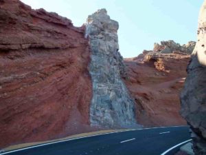
The seven major islands, one minor island, and several small islets were originally volcanic islands, formed by the Canary hotspot. The Canary Islands is the only place in Spain where volcanic eruptions have been recorded during the Modern Era, with some volcanoes still active (El Hierro, 2011). Volcanic islands such as those in the Canary chain often have steep ocean cliffs caused by catastrophic debris avalanches and landslides.
The Teide volcano on Tenerife is the highest mountain in Spain, and the third tallest volcano on Earth on a volcanic ocean island. All the islands except La Gomera have been active in the last million years; four of them (Lanzarote, Tenerife, La Palma and El Hierro) have historical records of eruptions since European discovery. The islands rise from Jurassic oceanic crust associated with the opening of the Atlantic. Underwater magmatism commenced during the Cretaceous, and reached the ocean’s surface during the Miocene. The islands are considered as a distinct physiographic section of the Atlas Mountains province, which in turn is part of the larger African Alpine System division.
In the summer of 2011 a series of low-magnitude earthquakes occurred beneath El Hierro. These had a linear trend of northeast-southwest. In October a submarine eruption occurred about 2 km (1 1⁄4 mi) south of Restinga. This eruption produced gases and pumice, but no explosive activity was reported.
Volcanism in Canary Islands
Volcanism in this ∼800-km-long and ∼400-km-wide volcanic belt (located at 33–27°N and 18–12°W) decreases in age from the northeast (Lars Seamount, 68 million years) to the southwest (Hierro Island, 1 million years) and is interpreted to represent the Canary hotspot track. The Canary volcanic province is located on Jurassic ocean crust (∼150 million years old beneath the western part of the province to ∼180 million years old beneath the eastern part of the province), and contains some of the oldest ocean crust preserved in ocean basins.
Dyke descriptions
Dyke diversity and morphology
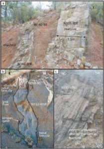
The dyke morphology is diverse, ranging from massive to intensely fractured or crushed, from highly vesicular to low vesicularity and from straight to bendy (Fig. 2). Orientations of individual dykes are usually constant at the outcrop scale, but local changes in strike, in dip or both have sometimes been observed (Fig. 2a, b). Changes in orientation (strike, dip or both) can occur at the boundary between layers of different competence, such as between a lava flow and its basal breccia, but occurs also within the same layer (e.g. Hoek 1995; Gudmundsson 2002).
Vesicle shapes and sizes are also variable. An interesting feature to note is that sometimes vesicles concentrate along straight bands parallel to dyke margins and, when their number and size becomes significant, they form fracture-like parallel structures within the dykes (Fig. 2c). In such cases, vesicles are elongate, stretched and often ruptured.
A few dykes contain centimetre-sized xenoliths of local country rock. Short finger-like intrusions into the adjacent rocks are sometimes observed (Fig. 2b), similar to those described by e.g. Mathieu and van Wyk de Vries (2009). These intrusive fingers may be tension gash-like features or dyke tip branching relics.
Dyke thickness and density
The average of all dyke thicknesses for the entire study area is 128 cm (Fig. 1,N0531 dykes). Dyke thicknesses for each sector (Fig. 1b) are displayed and were calculated as follows: when only an estimate of a dyke’s thicknesse was available, i.e. dykes observed from a distance, the values were not taken into account for the calculation. Within a dyke, thickness variations can occur, especially when the dyke passes from a low competence zone (e.g. scoria) into a more resistant stratum (e.g. a lava flow) where the dyke becomes thinner (see the Electronic Supplementary Material). If a dyke was accessible and measurable with a tape measure, then the thickest part of the dyke was considered.
Reference:
- Canary Islands
- https://core.ac.uk/download/pdf/11896861.pdf
- Dykes and structures of the NE rift of Tenerife, Canary Islands: A record of stabilisation and destabilisation of ocean island rift zones


