Using satellite imagery to monitor which volcanoes are deforming provides statistical evidence of their eruption potential, according to a new study in Nature Communications.
The European Space Agency’s Sentinel satellite, launched April 3, should allow scientists to test this link in greater detail and eventually develop a forecast system for all volcanoes, including those that are remote and inaccessible.
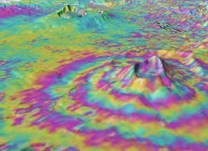
Volcano deformation and, in particular, uplift are often considered to be caused by magma moving or pressurizing underground. Magma rising towards the surface could be a sign of an imminent eruption. On the other hand, many other factors influence volcano deformation and, even if magma is rising, it may stop short, rather than erupting.
Satellite interferometric synthetic aperture radar, called InSAR for short, is a spaceborne imaging technology that will help scientists understand how volcanoes work, according to study co-author and geophysicist Zhong Lu, Southern Methodist University in Dallas.
“InSAR will aid in the prediction of future eruptions,” said Lu, a professor and Shuler-Foscue Chair of geophysics in SMU’s Roy M. Huffington Department of Earth Sciences. “At SMU, we are developing and applying this technique to track motions of volcanic activities, landslide movements, land subsidence and building stability, among other events.”
Juliet Biggs, the University of Bristol in England, led the study. Biggs looked at the archive of satellite data covering more than 500 volcanoes worldwide, many of which have been systematically observed for more than 18 years.
Satellite radar can provide high-resolution maps of deformation, allowing the detection of unrest at many volcanoes that might otherwise go unrecognized. Such satellite data is often the only source of information for remote or inaccessible volcanoes.
The researchers, who included scientists from Cornell University and Oxford University also, applied statistical methods more traditionally used for medical diagnostic testing and found that many deforming volcanoes also erupted (46 percent). Together with the very high proportion of non-deforming volcanoes that did not erupt (94 percent), these jointly represent a strong indicator of a volcano’s long-term eruptive potential.
“The findings suggest that satellite radar is the perfect tool to identify volcanic unrest on a regional or global scale and target ground-based monitoring,” Biggs said.
New technology may improve forecasting of volcanic eruptions
The work was co-funded by the U.K. Centre for Observation and Modelling of Earthquakes, Volcanoes and Tectonics and STREVA, a research consortium aimed at finding ways to reduce the negative consequences of volcanic activity on people and their assets.
“Improving how we anticipate activity using new technology such as this is an important first step in doing better at forecasting and preparing for volcanic eruptions,” said STREVA Principal Investigator Jenni Barclay.
Global studies of volcano deformation using satellite data will increasingly play a part in assessing eruption potential at more and more volcanoes, said researcher Willy Aspinall, University of Bristol, especially in regions with short historical records or limited conventional monitoring.
However, many factors and processes, some observable, but others not, influence deformation to a greater or lesser extent. These include the type of rock that forms the volcano, its tectonic characteristics and the supply rate and storage depth of magma beneath it. Thus deformation can have different implications for different types of volcanoes.
For volcanoes with short eruption cycles the satellite record typically spans episodes that include both deformation and eruption, resulting in a high correlation between the two. For volcanoes with long eruption cycles the satellite record tends to capture either deformation or eruption but rarely both.
Seismological data indicate unrest before eruption may only be a few days
In the past, radar images of the majority of the world’s volcanoes were only acquired a few times a year, but seismological data indicate that the duration of unrest before an eruption might be as short as only a few days.
“This study demonstrates what can be achieved with global satellite coverage even with limited acquisitions,” Biggs said, “so we are looking forward to the step-change in data quantity planned for the next generation of satellites.”
The European Space Agency launched its latest radar mission, Sentinel-1, in early April. The mission is designed for global monitoring and will collect images every six to twelve days. Using this, scientists should be able to test the causal and temporal relationship with deformation on much shorter timescales.
“This study is particularly exciting because Sentinel-1 will soon give us systematic observations of the ups and downs of every volcano on the planet,” said Tim Wright, director of the U.K. Centre for Observation and Modelling of Earthquakes. “For many places, particularly in developing countries, these data could provide the only warning of an impending eruption.”
Note : The above story is based on materials provided by Southern Methodist University


