RENO, Nev. – Like a detective story with twists and turns in the plot, scientists at the University of Nevada, Reno are unfolding a story about the rapid uplift of the famous 400-mile long Sierra Nevada mountain range of California and Nevada.
The newest chapter of the research is being published today in the scientific journal Nature, showing that draining of the aquifer for agricultural irrigation in California’s Central Valley results in upward flexing of the earth’s surface and the surrounding mountains due to the loss of mass within the valley. The groundwater subsidence was found to also correlate with seismic activity on the San Andreas Fault.
University of Nevada, Reno Research Professor Geoff Blewitt also told the story in a presentation at the European Geophysical Sciences Union conference in Vienna, Austria on April 28. The annual EGU General Assembly is the largest and most prominent European geosciences event. It attracts over 11,000 scientists from all over the world.
“We first wrote two years ago about the rapid rise of the Sierra, with its 14,000-foot peaks in the south and 10,000-foot peaks at Lake Tahoe, moving as much as 1 to 3 millimeters per year,” said Blewitt, of the Nevada Bureau of Mines and Geology, a division of the College of Science. “The puzzling results of our earlier research cannot be explained easily by geology alone. We’ve now found that a reason for the rapid uplift may be linked to human activity.”
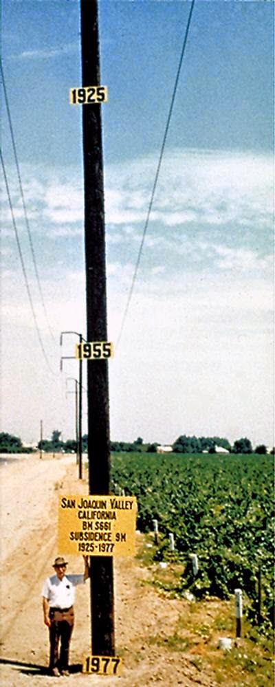
Over the past 150 years, around 40 trillion gallons of groundwater in California’s Central Valley has been lost through pumping, irrigation and evapotranspiration. That’s roughly equal to all the water in Lake Tahoe, the volume of which can cover the entire state of California in 14 inches of water.
“This massive withdrawal of water has relieved pressure on the Earth’s crust, which is now rebounding upwards in response,” Blewitt said. “This is counter-intuitive to most people, even geologists, who tend to only think that water withdrawal causes subsidence, which is only true in the sediments of the valley from which the water is withdrawn. With the weight of the groundwater missing, the hard-rock crust under the valley is actually rising too.”
The rise is quite fast in geologic time, with these mountain ranges rising by a similar amount each year – about the thickness of a dime – with a cumulative rise over the past 150 years of up to 6 inches, according to the calculations by the team of geophysicists.
Blewitt and colleague Bill Hammond, who run the Nevada Geodetic Laboratory at the University of Nevada, Reno, partnered with the University of Western Washington, the University of California, Berkeley and the University of Ottawa in the research.
“The real importance of this research is that we are demonstrating a potential link between human activity and deformation of the solid Earth, which explains current mountain uplift and the yearly variation in seismicity,” said Colin Amos, assistant professor of geology from Western Washington University and lead author of the Nature article. “These are questions that lots of geologists have been puzzling over, and it’s a real eye opener to think that humans are the ultimate cause.”
The study is based on detailed GPS measurements from California and Nevada between 2007 and 2010. Also working on the study were Pascal Audet of the University of Ottawa and Roland Bürgmann, professor of earth and planetary science at the University of California, Berkeley. The detailed GPS analysis was performed by Hammond and Blewitt with support from the National Science Foundation.
Hammond and Blewitt use data from their Nevada Geodetic Lab and its MAGNET GPS Network, the largest GPS data-processing center in the world, able to process information from about 12,000 stations around the globe continuously, 24/7. The facility measures the shape of the Earth every day using data drawn in from the global network with stations on every continent around the planet, including more than 1,200 stations from the NSF EarthScope Plate Boundary Observatory, as well as stations in space. The space-based radar data comes from the European Space Agency with support from NASA.
“We can sense the long-term flexing of the crust that accompanies trends in climate and related seasonal changes in the Earth’s surface that track yearly precipitation,” Hammond said. “The processing facility at the Nevada Geodetic Laboratory makes it possible to interpret trends in over 500 locations in southern California, needed to measure the centimeter-scale changes these loads produce. It makes it possible for scientists to connect climatic changes to subsidence patterns and the rate of earthquake occurrence.”
“The data is like a gold mine, we keep digging for new discoveries,” he said. “Scientists around the world use it extensively for research such as modeling earthquakes and volcanoes.”
Note : The above story is based on materials provided by University of Nevada, Reno


