Home Blog Page 199

Scientists Discover Butterfly-like Fossil Insect in the Deep Mesozoic

Scientists Discover Butterfly-GeologyPage
This is an artist’s rendering of Oregramma illecebrosa consuming pollen drops from bennettitales, an extinct order of plant from the Triassic period. Credit: Vichai Malikul

Large butterfly-like insects known as Kalligrammatid lacewings, which fluttered through Eurasian fern- and cycad-filled woodland during the Mesozoic Era, have been extinct for more than 120 million years. But with new fossil analyses, scientists at the Smithsonian’s National Museum of Natural History have discovered that these ancient lacewings were surprisingly similar to modern butterflies, which did not appear on Earth for another 50 million years.

Through taxonomic, anatomical and geochemical studies, scientists led by Smithsonian paleoecologist Conrad Labandeira revealed that Kalligrammatid lacewings likely served as important pollinators during mid-Mesozoic times, using mouthparts that were strikingly similar to the elongated, tubular structures that modern butterflies have to sip nectar-like fluids from flowering plants. What’s more, their wings bore eyespot patterns that closely resemble those found on some butterflies today, which may have helped to distract or deter potential predators.

Labandeira and his colleagues–an international team of geochemists, botanists, entomologists and paleobiologists–reported their findings Feb. 3, in the journal Proceedings of the Royal Society B. Their findings represent a striking example of convergent evolution between these two unrelated lineages, in which the two distinct groups of organisms evolve similar traits as they interact to similar features in their environments.

Paleobiologists have known for more than 100 years that Kalligrammatid lacewings lived in Eurasia during the Mesozoic. But the insects have remained largely enigmatic until recent discoveries of well-preserved fossils from two sites in northeastern China. Thanks to extensive lakes that limited oxygen exposure in these areas during mid-Jurassic through early Cretaceous time, paleontologists have been able to recover exquisitely preserved fossils that retain much of their original structure.

Labandeira, who is the museum’s curator of fossil arthropods, began the analysis of Kalligrammatid fossils from these sites by producing precise drawings of specimens using a camera lucida. This projection device lets artists trace fine features, such as the head and mouthparts of insects, while viewing them under a microscope. Labandeira’s drawings depicted insects with surprisingly long, tubular proboscises. “Various features of the mouthparts all indicate that these things were sucking fluids from the reproductive structures of gymnosperm plants,” Labandeira said. That idea was supported by an analysis of a bit of material lingering within the food tube of one fossil, which was found to contain only carbon. Had the insect been feeding on blood, its final meal would have left traces of iron in the food tube as well.

Although the lacewings’ mouthparts were strikingly similar to those of modern butterflies, there were no nectar-producing flowers in these Mesozoic forests. Paleobotanist David Dilcher of Indiana University, a member of the research team, said that like many Mesozoic insects, Kalligrammatids would have fed on sugary pollen drops produced by seed plants, transferring pollen between male and female plant parts as they did so. A now-extinct group of plants called bennettitaleans, whose deep, tubular reproductive structures may have been accessed by kalligrammatid proboscises, likely was the primary food source for the co-occurring lacewings. But variations in proboscis shapes among the fossils suggest the insects were associated with a wide variety of host plants.

Careful observation of the fossils also revealed the presence of scales on wings and mouthparts, which, like the scales on modern butterflies, likely contained pigments that gave the insects vibrant colors. Based on similarities between Kalligrammatid wing patterns and those found on modern nymphalid butterflies (a group that includes red admirals and painted ladies), Labandeira said Kalligrammatids might have been decorated with red or orange hues.

That discovery prompted the team to examine the chemical composition of various regions of the Kalligrammatid’s patterned wings, particularly the wing eyespots, an eye-like marking that might have deterred potential predators in Mesozoic woodlands. In modern butterflies with eyespots, the dark center of the mark is formed by a concentration of the pigment melanin. A sensitive chemical analysis indicated that the Kalligrammatids, too, had melanin at the center of their eyespots.

“That, in turn, suggests that the two groups of insects share a genetic program for eyespot production,” Labandeira said. “The last common ancestor of these insects lived about 320 million years ago, deep in the Paleozoic. So we think this must be a developmental mechanism that goes all the way back to the origins of winged insects.”

Taken together, the team’s findings highlight two ways in which relationships between plant-hosts and their pollinator species drove evolution, Dilcher said. “Here, we’ve got coevolution of plants with these animals due to their feeding behavior, and we’ve got coevolution of the lacewings and their predators. It’s building a web of life that is more and more complex.”

Reference:
Conrad C. Labandeira, Qiang Yang, Jorge A. Santiago-Blay, Carol L. Hotton, Antónia Monteiro, Yong-Jie Wang, Yulia Goreva, ChungKun Shih, Sandra Siljeström, Tim R. Rose, David L. Dilcher, Dong Ren. The evolutionary convergence of mid-Mesozoic lacewings and Cenozoic butterflies. Proceedings of the Royal Society B: Biological Sciences, 2016; 283 (1824): 20152893 DOI: 10.1098/rspb.2015.2893

Note: The above post is reprinted from materials provided by Smithsonian.

Consistency of Earth’s magnetic field history surprises scientists

Consistency of Earth's -GeologyPage
This figure illustrates superchrons of both normal and reversed polarity over time as the Earth’s molten core formed and solidified. It is provided courtesy of Peter Driscoll and David Evans Credit: Peter Driscoll and David Evans

Earth’s magnetic field is generated by the motion of liquid iron in the planet’s core. This “geodynamo” occasionally reverses its polarity–the magnetic north and south poles swap places. The switch occurs over a few thousand years, and the time between reversals can vary from some tens of thousands to tens of millions of years.

When magnetic polarity remains stable in one orientation for more than 10 million years the interval is dubbed a “superchron.” Within the last 540 million years–the time when animals have roamed the Earth’s land and seas–there are three known superchron periods, occurring about once every 200 million years.

The question of how frequently reversals and superchrons occurred over a longer segment of Earth’s history is important for understanding the long-term evolution of the internal and surface conditions of our planet. But so far, such information has only been pieced together by fragmentary evidence. New work from Carnegie’s Peter Driscoll and David Evans of Yale University now identifies as many as 10 additional superchrons over a 1.3 billion-year stretch of time during the Proterozoic Eon, or Earth’s middle age, which occurred 2.5 to 0.54 billion years ago. Their work is published in the March 1st issue of Earth and Planetary Science Letters.

Records of magnetic field reversals can be found in rocks that maintain the magnetic polarity of the era in which they formed. In order to establish evidence of a polarity shift, this kind of ancient magnetic, or “paleomagnetic,” data must be gathered from around the globe, ideally sampling every tectonic plate.

Driscoll and Evans compiled a database of global paleomagnetic data from the Proterozoic, and coordinated their reversal records with the movements of the tectonic plates to look for long periods with either strongly northern or southern polarity dominance. These super-long periods of polarity bias then revealed the previously unknown ancient superchrons.

“Our study points the way towards new questions about fundamental aspects of Earth’s evolution,” Driscoll said. “One of the major implications of these findings is that geodynamo-driven superchrons have occurred at a similar rate for most of the past two billion years.”

This was surprising, because geophysicists have good reason to suspect that there was a major change in Earth’s core within that time interval. Due to Earth steadily cooling, losing heat to space since the time of its formation, the planet’s inner core–a giant mass of solid iron at the center of the planet–should have started to crystallize between about a half billion and one billion years ago. The growth of the solid inner core is fundamental to the physics of the geodynamo. Computer simulations of reversal rates are very different depending on whether or not the planet has a solid inner core.

One possible explanation for Driscoll and Evans’s new result is that the Earth’s inner core is actually much older than has been previously estimated, but this idea would conflict strongly with the most-reasonable planetary cooling models. Another explanation invokes an unexpected resilience of the geodynamo in the face of dramatic changes to its structure, including something as fundamental as the solidification of the inner core.

“We think the latter is more likely,” Driscoll added. “But regardless of which answer is correct, these results mean that we may need to rethink our models for either core evolution or the geodynamo process.”

Note: The above post is reprinted from materials provided by Carnegie Institution.

A penis in amber

A penis in amber-GeologyPage
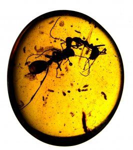
Fossil penis of Halitherses grimaldii. Credit: Jason Dunlop, MfN Berlin

A research team led by Jason Dunlop from the Museum für Naturkunde Berlin, Germany, published in the international journal The Science of Nature the unusual discovery of a 99 million year old harvestman with an extended penis. Male harvestmen transfer sperm directly into the female. In modern animals the fine structure of this penis is extremely important for identifying and placing the different species. The new fossil discovery shows that harvestmen in the Cretaceous mated in the same way as animals today. Based on the large eyes and spatula-like penis tip, the scientists were also able to describe the fossil in a new, extinct family.

Harvestmen (Opiliones) are a diverse group of arachnids with more than 6,600 described species. Only a few fossil species (38) are known, among them Halitherses grimaldii from the ca. 99 million year old Burmese amber from Myanmar in South-east Asia. This species was first discovered in 2005, but proved to be difficult to place in the harvestman family tree. An international research team led by Jason Dunlop from the Museum für Naturkunde Berlin discovered a new example of this species which proved to be particularly important in that – for the first time – the male genitalia (the penis) is clearly visible.

Normally this male organ is hidden within the body when not in use. By chance, in this extraordinary amber fossil the penis is preserved fully extended outside the body. It shows that Cretaceous harvestmen also used a penis to transfer sperm directly into the female’s body. In the taxonomy of modern harvestmen penis anatomy is extremely important: each species has its own unique structure. Also the major groups (or families) of the harvestmen have different penis forms. So far only a few fossil harvestmen have revealed their penis, which makes it difficult to compare them effectively with living species.

In Halitherses grimaldii the penis is spatula-shaped at the tip and is heart-shaped in outline, with a small tube extending from the very end. No living harvestman has a penis with exactly this shape. Also unusual are the large eyes of the fossil, although new results suggest that such large eyes are probably a primitive character in these harvestmen. In other words some early harvestmen should have had large eyes. This combination of features enabled the scientists to propose a new (extinct) family, Halithersidae, within the suborder Dyspnoi. This is the first time that a fossil family has been defined using a mixture of features relating to both the body and the genitalia, and allowed the researchers to study the relationships of these ancient fossils using the same approaches that they would use for living species.

A fossil harvestman (Arachnida, Opiliones), Halitherses grimaldii Giribet and Dunlop, 2005, from the Cretaceous Burmese amber of Myanmar. a Lateral overview showing the penis (arrowed). Scale bar 1.0 mm. b Details of penis morphology. Scale bar 0.2 mm. Credit: The Science of Nature (2016). DOI: 10.1007/s00114-016-1337-4

Reference:
Jason A. Dunlop et al. Penis morphology in a Burmese amber harvestman, The Science of Nature (2016). DOI: 10.1007/s00114-016-1337-4

Note: The above post is reprinted from materials provided by Museum für Naturkunde.

Lava flow crisis averted (for now)

Lava flow crisis averted-GeologyPage
Lava destroys a small orchard in Pahoa, Hawaii, 28 Oct. 28 2014, as it advances toward the main road through the village. The plume in the background is from a burning pile of tires ignited by lava. Credit: GSA Today, USGS, Kyle Anderson

Lava flow crises are nothing new on Hawai’i, where their destructive forces have been demonstrated repeatedly. The 2014-2015 Pahoa lava flow crisis, however, was unique in terms of its societal impact and volcanological characteristics. Despite a low effusion rate, the long-lived lava flow, whose extent reached 20 km (the longest at Kilauea Volcano in hundreds of years), was poised for months to impact thousands of people, although direct impacts were ultimately minor (thus far).

Kilauea’s outbreak was noteworthy for its potential (and uncertain) impact and long months of anticipation by communities at risk. Had the flow extended far enough along the path it was following, it would have crossed a highway used by thousands of vehicles each day; isolated a portion of the island that is home to nearly 10,000 residents; cut power, water, and other infrastructure on which those residents depend; and overrun homes in multiple communities. The flow stalled repeatedly within several hundred meters of the highway, destroying only one house before breakouts ~15 km upslope in March 2015 diverted lava away from the front.

The activity provided new information about the behavior of pahoehoe lava flows, as well as lessons about communicating information to the public during a prolonged crisis. Although the 2014-2015 crisis has passed, the lava flow remains active and could threaten communities in the future.

Communicating uncertainty associated with lava flow hazards was a challenge throughout the crisis, but online distribution of information and direct contact with residents proved to be effective strategies for keeping the public informed and educated about flow progress and how lava flows work (including forecasting limitations). Volcanological and sociological lessons will be important for inevitable future lava flow crises in Hawai’i and, potentially, elsewhere in the world.

Reference:
Benjamin D. DeJong, Paul R. Bierman, Wayne L. Newell, Tammy M. Rittenour, Shannon A. Mahan, Greg Balco, Dylan H. Rood. Pleistocene relative sea levels in the Chesapeake Bay region and their implications for the next century. GSA Today, 2015; 4 DOI: 10.1130/GSATG223A.1

Note: The above post is reprinted from materials provided by Geological Society of America.

Extracting rare-earth elements from coal could soon be economical in US

Extracting rare-earth elements-GeologyPage
Rare-earth oxides, clockwise from top center: praseodymium, cerium, lanthanum, neodymium, samarium, and gadolinium. Credit: Peggy Greb / USDA

The U.S. could soon decrease its dependence on importing valuable rare-earth elements that are widely used in many industries, according to a team of Penn State and U.S. Department of Energy researchers who found a cost-effective and environmentally friendly way to extract these metals from coal byproducts.

Rare-earth elements are a set of seventeen metals — such as scandium, yttrium, lanthanum and cerium — necessary to produce high-tech equipment used in health care, transportation, electronics and numerous other industries. They support more than $329 billion of economic output in North America, according to the American Chemistry Council, and the United States Geological Survey expects worldwide demand for REEs to grow more than 5 percent annually through 2020. China produces more than 85 percent of the world’s rare-earth elements, and the U.S. produces the second most at just over 6 percent, according to the USGS.

“We have known for many decades that rare-earth elements are found in coal seams and near other mineral veins,” said Sarma Pisupati, professor of energy and mineral engineering, Penn State. “However, it was costly to extract the materials and there was relatively low demand until recently. Today, we rely on rare-earth elements for the production of many necessary and also luxury items, including computers, smart phones, rechargeable batteries, electric vehicles, magnets and chemical catalysts. We wanted to take a fresh look at the feasibility of extracting REEs from coal because it is so abundant in the U.S.”

Using byproducts of coal production from the Northern Appalachian region of the U.S., the team investigated whether a chemical process called ion exchange could extract REEs in a safer manner than other extraction methods. For example, past research has examined “roasting,” a process that is energy intensive and requires exposure to concentrated acids. In contrast, ion exchange is more environmentally friendly and requires less energy. Ion exchange involves rinsing the coal with a solution that releases the REEs that are bound to the coal.

“Essentially, REEs are sticking to the surface of molecules found in coal, and we use a special solution to pluck them out,” said Pisupati. “We experimented with many solvents to find one that is both inexpensive and environmentally friendly.”

The team reported in their findings, published in the current issue of Metallurgical and Materials Transactions E, that ammonium sulfate was both environmentally friendly and able to extract the highest amount of REEs. Extracting 2 percent of the available REEs would provide an economic boon to companies, the team said.

“We were able to very easily extract 0.5 percent of REEs in this preliminary study using a basic ion exchange method in the lab,” said Pisupati. We are confident that we can increase that to 2 percent through advanced ion exchange methods.”

The researchers used coal byproducts in their study, some of which were discarded or marked as refuse during mining operations due to poor quality. Finding more uses for discarded coal could provide yet another economic benefit to companies.

In their study, the team also identified the locations within the coal seam that contained the highest amounts of REEs. Often the highest concentration is found in the poorest quality coal, said Pisupati.

“You find some REEs in the coal itself, but the highest concentration is in what we call the coal shale, or the top layer of a coal seam. Knowing this, we can further target our operations to be more efficient,” he said.

The team is now collaborating with several Pennsylvania coal-mining companies to explore the viability of a commercial REE-extraction operation.

Note: The above post is reprinted from materials provided by Penn State.

New technique to find copper deposits

New technique to find-GeologyPage
Magmatic rock which formed large porphyry deposit in Chile. Credit: University of Exeter

A geologist at the University of Exeter has developed a new and relatively inexpensive way to establish whether certain types of magmatic rocks are more likely to contain valuable metal deposits.

In a study published in Nature Geoscience, Dr Ben Williamson, of the University’s Camborne School of Mines, together with Dr Richard Herrington from the Natural History Museum, London, have proposed a new method to explore for porphyry-type copper deposits. These deposits provide around 75 per cent of the world’s copper and a significant amount of molybdenum and gold which makes them extremely important to the world economy. The deposits, which originally form at several kilometres depth below Earth’s surface, above large magma chambers, are relatively rare, particularly the largest deposits which are most economic to mine. In addition, most near-surface deposits have already been discovered. Any new method to locate deeper deposits is therefore of great interest to the mining industry.

The project, funded by Anglo American, a major global mining company, compared the chemical compositions of minerals from magmatic rocks that host porphyry deposits against those which are barren. A case study was then undertaken of a major new porphyry discovery in Chile, to test their theory. Minerals from magmatic rocks which host porphyry deposits have distinctive chemical characteristics which can be used as one of a suite of indicators to home-in on porphyry deposits. Unravelling the causes of the distinctive chemical signatures has also brought new insights into the formation of porphyry copper deposits, and more generally the generation of the magmatic rocks from which they form, which are an important component of Earth’s crust. The main finding in this regard is that the magma chamber below the porphyry undergoes discrete injections of water-rich melts or watery fluids which enhance the magma’s ability to transfer copper and other metals upwards to form a porphyry copper deposit.

Dr Ben Williamson, of the University of Exeter’s Camborne School of Mines, said: “This new method will add to the range of tools available to exploration companies to discover new porphyry copper deposits. Our findings also provide important insights into why some magmas are more likely to produce porphyry copper deposits than others, and add to our understanding of how their parent magmatic rocks evolve.”

Reference:
B. J. Williamson, R. J. Herrington, A. Morris. Porphyry copper enrichment linked to excess aluminium in plagioclase. Nature Geoscience, 2016; DOI: 10.1038/ngeo2651

Note: The above post is reprinted from materials provided by University of Exeter.

Increase in volcanic eruptions at the end of the ice age caused by melting ice caps and erosion

Increase in volcanic eruptions-GeologyPage
This is a 3-D model simulation of a glaciation on the Villarrica Volcano (Chile). Credit: Pietro Sternai

The combination of erosion and melting ice caps led to a massive increase in volcanic activity at the end of the last ice age, according to new research. As the climate warmed, the ice caps melted, decreasing the pressure on the Earth’s mantle, leading to an increase in both magma production and volcanic eruptions. The researchers, led by the University of Cambridge, have found that erosion also played a major role in the process, and may have contributed to an increase in atmospheric carbon dioxide levels.

“It’s been established that melting ice caps and volcanic activity are linked — but what we’ve found is that erosion also plays a key role in the cycle,” said Dr Pietro Sternai of Cambridge’s Department of Earth Sciences, the paper’s lead author, who is also a member of Caltech’s Division of Geological and Planetary Science. “Previous attempts to model the huge increase in atmospheric CO2 at the end of the last ice age failed to account for the role of erosion, meaning that CO2 levels may have been seriously underestimated.”

Using numerical simulations, which modelled various different features such as ice caps and glacial erosion rates, Sternai and his colleagues from the University of Geneva and ETH Zurich found that erosion is just as important as melting ice in driving the increase in magma production and subsequent volcanic activity. The results are published in the journal Geophysical Research Letters.

Although the researchers caution not to draw too strong a link between anthropogenic (human-caused) climate change and increased volcanic activity as the timescales are very different, since we now live in a period where the ice caps are being melted by climate change, they say that the same mechanism will likely work at shorter timescales as well.

Over the past million years, the Earth has gone back and forth between ice ages, or glacial periods, and interglacial periods, with each period lasting for roughly 100,000 years. During the interglacial periods, such as the one we live in today, volcanic activity is much higher, as the lack of pressure provided by the ice caps means that volcanoes are freer to erupt. But in the transition from an ice age to an interglacial period, the rates of erosion also increase, especially in mountain ranges where volcanoes tend to cluster.

Glaciers are considered to be the most erosive force on Earth, and as they melt, the ground beneath is eroded by as much as ten centimetres per year, further decreasing the pressure on the volcano and increasing the likelihood of an eruption. A decrease in pressure enhances the production of magma at depth, since rocks held at lower pressure tend to melt at lower temperatures.

When volcanoes erupt, they release more carbon dioxide into the atmosphere, creating a cycle that speeds up the warming process. Previous models that attempted to explain the increase in atmospheric CO2 during the end of the last ice age accounted for the role of deglaciation in increasing volcanic activity, but did not account for erosion, meaning that CO2 levels may have been significantly underestimated.

A typical ice age lasting 100,000 years can be characterised into periods of advancing and retreating ice — the ice grows for 80,000 years, but it only takes 20,000 years for that ice to melt.

“There are several factors that contribute to climate warming and cooling trends, and many of them are related to the Earth’s orbital parameters,” said Sternai. “But we know that much faster warming that cooling can’t be caused solely by changes in the Earth’s orbit — it must be, at least to some extent, related to something within the Earth system itself. Erosion, by contributing to unload the Earth’s surface and enhance volcanic CO2 emissions, may be the missing factor required to explain such persistent climate asymmetry.”

Reference:
Pietro Sternai, Luca Caricchi, Sébastien Castelltort, Jean-Daniel Champagnac. Deglaciation and glacial erosion: a joint control on magma productivity by continental unloading. Geophysical Research Letters, 2016; DOI: 10.1002/2015GL067285

Note: The above post is reprinted from materials provided by University of Cambridge. The original story is licensed under a Creative Commons Licence.

Expedition recovers mantle rocks with signs of life

Expedition recovers-GeologyPage

An international team of scientists — recently returned from a 47-day research expedition to the middle of the Atlantic Ocean — have collected an unprecedented sequence of rock samples from the shallow mantle of the ocean crust that bear signs of life, unique carbon cycling, and ocean crust movement. Led by Co-Chief Scientists Dr. Gretchen Früh-Green (ETH Zurich, Switzerland) and Dr. Beth Orcutt (Bigelow Laboratory for Ocean Sciences, USA), the team collected these unique rock samples using seabed rock drills from Germany and the UK — the first time in the history of the decades-long scientific ocean drilling program that such technology has been utilized.

The aims of the expedition are to determine how mantle rocks are brought to the seafloor and react with seawater — such reactions may fuel life in the absence of sunlight, which may be how life developed early in Earth’s history, or on other planets. The team also hopes to learn more about what happens to carbon during the reactions between the rocks and the seawater — processes that could impact on climate by sequestering carbon.

“The rocks collected on the expedition provide unique records of deep processes that formed the Atlantis Massif. We will also gain valuable insight into how these rocks react with circulating seawater at the seafloor during a process we call serpentinization and its consequences for chemical cycles and life” stated expedition Co-Chief Scientist Gretchen Früh-Green.

“During drilling, we found evidence for hydrogen and methane in our samples, which microbes can ‘eat’ to grow and form new cells,” explained Beth Orcutt, Co-Chief Scientist from Bigelow Laboratory. “Similar rocks and gases are found on other planets, so by studying how life exists in such harsh conditions deep below the seafloor, we inform the search for life elsewhere in the Universe.”

The scientists are part of the International Ocean Discovery Program (IODP) Expedition 357, conducted by the European Consortium for Ocean Research Drilling (ECORD) as part of the IODP. The expedition set off from Southampton, UK, on October 26, 2015, aboard the Royal Research Vessel James Cook (operated by the National Environment Research Council, UK), returning on December 11, 2015. They brought with them the Rock Drill 2 from the British Geological Survey and the MeBo rock drill from MARUM in Bremen, Germany, for around-the-clock operations to collect rock cores from the Atlantis Massif, a 4,000-m tall underwater mountain along the Mid-Atlantic Ridge. The rock drills were equipped with new technologies to enable the scientists to detect signs of life in the rock samples.

During the past two weeks, the science party has been studying the rock samples in detail at the IODP Bremen Core Repository in Bremen, Germany. The science party consists of 31 scientists (16 female/15 male) from 13 different countries (Australia, Canada, China, France, Germany, Italy, Japan, Korea, Norway, Spain, Switzerland, UK, USA), ranging from students to tenured professors. At the end of this sampling party, the first results of the expedition will be reported.

Note: The above post is reprinted from materials provided by Bigelow Laboratory for Ocean Sciences.

Rapid formation of bubbles in magma may trigger sudden volcanic eruptions

Rapid formation of bubbles-GeologyPage
Gas emissions from the fumarole Pisciarelli at Campi Flegrei in southern Italy. Credit: Mike Stock

It has long been observed that some volcanoes erupt with little prior warning. Now, scientists have come up with an explanation behind these sudden eruptions that could change the way observers monitor active or dormant volcanoes.

Previously, it was thought eruptions were triggered by a build-up of pressure caused by the slow accumulation of bubbly, gas-saturated magma beneath volcanoes over tens to hundreds of years. But new research has shown that some eruptions may be triggered within days to months by the rapid formation of gas bubbles in magma chambers very late in their lifetime.

Using the Campi Flegrei volcano near Naples, southern Italy, as a case study, the team of scientists, from the universities of Oxford and Durham in the UK, and the Vesuvius Volcano Observatory in Italy, demonstrate this phenomenon for the first time and provide a mechanism to explain the increasing number of reported eruptions that occur with little or no warning.

The study is published in the journal Nature Geoscience.

Lead author Mike Stock, from the Department of Earth Sciences at the University of Oxford, said: ‘We have shown for the first time that processes that occur very late in magma chamber development can trigger explosive eruptions, perhaps in only a few days to months. This has significant implications for the way we monitor active and dormant volcanoes, suggesting that the signals we previously thought indicative of pre-eruptive activity – such as seismic activity or ground deformation – may in fact show the extension of a dormant period between eruptions.

‘Our findings suggest that, rather than seismic activity and ground deformation, a better sign of an impending eruption might be a change in the composition of gases emitted at the Earth’s surface. When the magma forms bubbles, the composition of gas at the surface should change, potentially providing an early warning sign.’

The researchers analysed tiny crystals of a mineral called apatite thrown out during an ancient explosive eruption of Campi Flegrei. This volcano last erupted in 1538 but has recently shown signs of unrest.

By looking at the composition of crystals trapped at different times during the evolution of the magma body – and with the apatite crystals in effect acting as ‘time capsules’ – the team was able to show that the magma that eventually erupted had spent most of its lifetime in a bubble-free state, becoming gas-saturated only very shortly before eruption. Under these conditions of slow magma chamber growth, earthquakes and ground deformation observed at the surface may not be signs of impending eruption, instead simply tracking the arrival of new batches of magma at depth.

Professor David Pyle from the Department of Earth Sciences at the University of Oxford, a co-author of the paper, said: ‘Now that we have demonstrated that this approach can work on a particular volcano, and given apatite is a mineral found in many volcanic systems, it is likely to stimulate interest in other volcanoes to see whether there is a similar pattern.

‘This research will also help us refine our ideas of what we want to measure in our volcanoes and how we interpret the long-term monitoring signals traditionally used by observers.’

The Campi Flegrei volcano system has had a colourful history. The Romans thought an area called Solfatara (where gas is emitted from the ground) was the home of Vulcan, the god of fire. Meanwhile, one of the craters in the system, Lake Avernus, was referred to as the entrance to Hades in ancient mythology.

Additionally, Campi Flegrei has long been a site of geological interest. In Charles Lyell’s 1830 Principles of Geology, he identified the burrows of marine fossils at the top of the Macellum of Pozzuoli (an ancient Roman market building), concluding that the ground around Naples rises and falls over geological time.

Reference:
Late-stage volatile saturation as a potential trigger for explosive volcanic eruptions, Michael J. Stock, Madeleine C. S. Humphreys, Victoria C. Smith, Roberto Isaia and David M. Pyle, Nature Geoscience, DOI: 10.1038/NGEO2639

Note: The above post is reprinted from materials provided by University of Oxford.

Some tiny plankton may have big effect on ocean’s carbon storage

Some tiny plankton may have-GeologyPage
“If (mixotrophs) weren’t in the oceans, we’re suggesting atmospheric carbon dioxide might be higher, because there would less of the large, carbon rich particles formed which efficiently transfer carbon to depth,” Mick Follows says. Credit: James Fraser/Biodiversity Heritage Library

How do you find your food? Most animal species, whether they rummage through a refrigerator or stalk prey in the wild, obtain nutrients by consuming living organisms. Plants, for the most part, adopt a different feeding, or “trophic,” strategy, making their own food through photosynthesis. There are, however, certain enterprising species that can do both: photosynthesize and consume prey. These organisms, found mostly in certain ocean plankton communities, live a flexible, “mixotrophic” lifestyle.

Now researchers at MIT and Bristol University in the United Kingdom have found that these microscopic, mixotrophic organisms may have a large impact on the ocean’s food web and the global carbon cycle.

The scientists developed a mixotrophic model of the global ocean food web, at the scale of marine plankton, in which they gave each plankton class the ability to both photosynthesize and consume prey. They found that, compared with traditional models that do not take mixotrophs into account, their model produced larger, heavier plankton throughout the ocean. As these more substantial microbes die, the researchers found they increase the flux of sinking organic carbon particles by as much as 35 percent.

The results, says Mick Follows, associate professor in MIT’s Department of Earth, Atmospheric and Planetary Sciences, suggest that mixotrophic organisms may make the ocean more efficient in storing carbon, which in turn enhances the efficiency with which the oceans sequester carbon dioxide.

“If [mixotrophs] weren’t in the oceans, we’re suggesting atmospheric carbon dioxide might be higher, because there would less of the large, carbon-rich particles formed which efficiently transfer carbon to depth,” Follows says. “It’s a hypothesis, but it has been ignored in carbon cycle models until now, and we suggest it must be represented because it’s potentially very important.”

Follows and his colleague Ben Ward, a former MIT postdoc now at Bristol University, have published their results today in the Proceedings of the National Academy of Sciences.

Part of the equation

Today’s ocean models typically take an “either/or” approach, grouping plankton as either photosynthesizers or consumers of prey. This approach, Follows says, oversimplifies the processes taking place in the ocean that may ultimately contribute to how carbon moves through the oceans and atmosphere. He says mixotrophs are often overlooked, because our terrestrial experience makes them seem rare.

“To us on land, we tend to think of [mixotrophs], like Venus fly traps, as exotic—they are a curiosity to us,” Follows says. “Our traditional perspective is biased by the land, where organisms fall into one or the other category, rather strictly. But in the oceans, the more people have looked at plankton, the more mixotrophy seems to be common.”

The problem is that there are very few data to work into models, as it’s extremely difficult to observe trophic strategies at the microscopic plankton scale. Therefore, models have largely left mixotrophs out of the equation and have instead looked to other marine processes to try and explain how much carbon is stored in the oceans.

“It’s like if we have a weather forecast model that gets the rain right in Boston today, but for the wrong reasons,” Follows says. “If we use it tomorrow, we shouldn’t expect it to do a good job, because it was cooked up for today. We want our climate model to be representative of the processes going on, in order to be predictive of how carbon storage responds to global change.”

Making a (mixotrophic) living

As a first step, Follows and Ward chose to simulate a virtual world in which every plankton class is potentially mixotrophic.

“It’s a very idealized, black-and-white case: What’s the maximum impact mixotrophs could have?” Follows says.

In the oceans, plankton can range in size from less than 1 micron, to about 1 millimeter in diameter. Typical ocean models that incorporate plankton often group them in 10 general size classes, each of which fall into a “two-guild” structure, as either photosynthesizers, or consumers of prey.

Instead, Follows and Ward made all of the plankton mixotrophic. The organisms in the model can photosynthesize, consuming inorganic nutrients. (The smallest organisms are the most efficient at acquiring those resources.) They can also eat other plankton and are constrained to consume prey in size classes about ten times smaller than themselves.

“After we have built in these rules for the system, whether each size class lives largely by photosynthesis or largely by predation depends upon the availability of each type of resource and their relative ability to harvest them in each environment,” Follows says.

After running the model forward, the researchers compared the results to those of a traditional model without mixotrophs. They found both models showed a general feeding structure throughout the plankton food web: The smallest organisms were too small to ingest prey, while the largest plankton were poor competitors when living by photosynthesis.

However, where the traditional model made a strict separation between those that photosynthesize and those that don’t, the mixotrophic model blurred those lines, with some smaller organisms consuming prey and some larger ones being able to photosynthesize. The result was that mixotrophic organisms in every class increased the average size of that organism, creating larger and heavier plankton throughout the oceans. These more substantial organisms, compared to smaller and lighter plankton, were more capable of sinking to the ocean floor, as carbon-containing detritus.

“It essentially means that, through multiple means, in a world with mixotrophs, more organic carbon is sinking into the deep ocean than in a world without mixotrophs,” Follows says.

The team’s estimate of the amount of sinking carbon contributed by mixotrophs appears to agree with recent observations of carbon flux by mixotrophic plankton in the North Atlantic. Follows says that, with more data on these opportunistic organisms, he hopes to improve the model to accurately reflect mixotrophic populations and their effect on the planet’s carbon cycle.

“Part of our hope is for the work is to give some wind to the sails of these observational studies. We think they’re very valuable,” Follows says. “There may be a large fraction of grazing that is being done by mixotrophs, so it’s potentially very significant in terms of the flow of carbon in the ocean and it should be quantified.”

Reference:
Ben A. Ward et al. Marine mixotrophy increases trophic transfer efficiency, mean organism size, and vertical carbon flux, Proceedings of the National Academy of Sciences (2016). DOI: 10.1073/pnas.1517118113

Note: The above post is reprinted from materials provided by Massachusetts Institute of Technology.

Can animals thrive without oxygen?

Can animals thrive-GeologyPage
Deep Hypersaline Anoxic Basins, or DHABs, are lakes of ultra-salty, no-oxygen water more than a mile below the surface of the ocean. They are some of the most extreme environments on Earth. Credit: Jack Cook, Woods Hole Oceanographic Institution

In 2010, a research team garnered attention when it published evidence of finding the first animals living in permanently anoxic conditions at the bottom of the sea. But a new study, led by scientists at the Woods Hole Oceanographic Institution (WHOI), raises doubts.

One alternative scenario is that cadavers of multicellular organisms were inhabited by bacteria capable of living in anoxic conditions, and these “bodysnatchers” made it seem that the dead animals were living, said Joan Bernhard, a geobiologist with WHOI and the lead author of the new study published in the December 2015 issue of the scientific journal BMC Biology.

Bernhard and Virginia Edgcomb, her colleague at WHOI, led an expedition in 2011 that returned to the site of the initial findings: a deep hypersaline anoxic basin (or DHAB) two miles deep in the Mediterranean Sea. DHABs are curious phenomena. They exist in depressions on the seafloor, where long-buried salt deposits become exposed to seawater and dissolve into the sea. The hypersaline water is extremely dense and remains separated, like oil and water, from surrounding normal seawater. It forms “lakes” on the seafloor, tens to hundreds of meters deep, that are extremely salty and devoid of oxygen.

“We have known for a long time that some metazoans inhabit extreme anoxic habitats on a periodic or even semi-permanent basis,” Bernhard said. “But scientists have thought that metazoan’s high-energy activities, such as reproduction, would require oxygen. If these loriciferans spend their whole lives and reproduce in a zero-oxygen environment, we would have to reconsider our concepts of animal metabolism. It was important to revisit the DHABs to confirm and understand those previous remarkable findings.”

In the 2010 study published in the same journal, researchers from Polytechnic University of Marche and the Natural History Museum of Denmark, led by Roberto Danovaro, analyzed samples collected from a Mediterranean DHAB called L’Atalante. They reported finding multicellular animals (or metazoans), including previously unknown species of a type of tiny animals called loriciferans.

The contrast between conditions at the seafloor and at the surface makes it nearly impossible to recover live specimens, and so in the past, metazoan specimens collected from DHABs have been “interpreted as the result of a rain of cadavers that sunk to the anoxic zone from adjacent oxygenated areas,” according to the Danovaro study.

But the scientists conducted experiments with fluorescent tags, taken up only by metabolically active organisms, which gave indications that the loriciferans had been alive. In addition, a few loriciferans appeared to have reproductive structures called oocytes (or eggs), indicating that the organisms were reproducing.

Intrigued by these findings, Bernhard and Edgcomb returned to L’Atalante and other nearby DHABs in 2011 to further investigate aboard the research vessel Atlantis. They collected sediment and water from the edges of three brine pools with different chemical compositions, using WHOI’s remotely operated vehicle Jason to visually guide carefully targeted push-core samples. Samples were taken from points in the upper, middle, and lower levels of the layer of water immediately overlying the brine lake. This so-called “interface zone” is where normal seawater at the top transitions to the brine at the bottom, becoming more concentrated and anoxic the closer to the brine. The highly dense, saline, chemical-laden and oxygen-depleted water in all three pools was too dense for Jason to fully penetrate. Control samples from nearby sediment and water of normal oxygen and salinity were also collected.

“It’s very difficult to get these samples,” Bernhard said. “We specifically targeted the interface zone, to have the best chance of finding living organisms.”

In some control samples, which were mud and water of normal oxygen levels, and also in some samples from the upper level of the interface zones, which have a low level of oxygen, Bernhard and colleagues found the same loriciferan species from L’Atalante reported by Danovaro and colleagues in the 2010 paper and formally named in a 2014 publication. Bernhard et al found the greatest number of metazoans were nematode worms, with much smaller numbers of bryozoans, crustaceans, and loriciferans, including the same three loriciferan genera Danovaro and colleagues reported. More metazoans were in the upper layer and far fewer in the middle and lower layers of the interface zone.

The WHOI-led team used a combination of techniques (including incubation with a marker of living tissue, ribosomal RNA sequencing to identify species, epifluorescence imagery, differential interference and phase contrast imagery, and ultrastructural examination of individual specimens, and more) to examine the metazoans collected in the samples.

The team’s results provided evidence that some nematodes were alive in both the normal sediment and the upper level of the interface zones. But in the lower interface, with almost no oxygen, the metazoans seen were degraded or only their outer coverings, called cuticles. “We found no evidence that these metazoans were living or reproducing in the deepest part of the interface,” Bernhard said.

They argue that it is very unlikely that the same loriciferan species that they found in normal (control) sediment would also be physiologically able live in the two very different hypersaline, hyperdense, hyper-chemical brine pools where they were collected, because the range of conditions is too wide to adapt to.

“The likelihood that they’d have the physiology to cope with all of that would be very low,” Bernhard said. “One alternative scenario,” the authors write, “is that remnant metazoa bodies were inhabited by [living] anaerobic bacteria and/or archaea,” which they colloquially called “bodysnatchers.”

“The possibility of a viable metazoan community in brines of DHABs is not supported by our data at this time,” the authors wrote in their new paper.

“That earlier group’s 2010 paper came out with such a splash,” Bernhard said. “But based on our detailed observations, our paper offers a different perspective on the assertion that there are permanently anoxic metazoans. Maybe people will see our paper and think ‘Maybe we don’t have to rewrite the basic biology textbooks yet.’ ”

Reference:
Joan M. Bernhard, Colin R. Morrison, Ellen Pape, David J. Beaudoin, M. Antonio Todaro, Maria G. Pachiadaki, Konstantinos Ar. Kormas, Virginia P. Edgcomb. Metazoans of redoxcline sediments in Mediterranean deep-sea hypersaline anoxic basins. BMC Biology, 2015; 13 (1) DOI: 10.1186/s12915-015-0213-6

Note: The above post is reprinted from materials provided by Woods Hole Oceanographic Institution.

Paleontologists link leg length to running ability in bipedal carnivorous dinosaurs

Paleontologists%2Blink%2Bleg%2Blength%2Bto-GeologyPage.jpg
Calculated speed adaptation scores for various dinosaurs. (From left) Guaibasaurus was an early dinosaur with a low score typical of primitive forms; despite its pop culture status, Velociraptor is revealed to be among the least swift of the carnivorous dinosaurs; the Jurassic predator Allosaurus was large and moderately adapted for speed; despite its bulk, Tyrannosaurus scores high on the speed charts; the controversial species Nanotyrannus was the bipedal dino best adapted for speed—the Usain Bolt of its era.

“How fast a predator can run is obviously important,” says University of Alberta paleontologist Scott Persons, who led the study as part of his doctoral research. “Speed determines what prey you can catch, how you hunt it and the sort of environment that you are most successful in. That’s true for modern carnivores, and must have been true for dinosaurs.”

The relationship between speed and leg length is a general anatomical rule observable today in living animals. For example, cheetahs are faster and have proportionately longer legs than lions, which are faster and have proportionately longer legs than hyenas.

Specifically, fast-running animals have proportionately longer lower legs—that is, their legs are lengthened from the knee down. As a rule, the longer the lower leg is in comparison with the upper leg, the faster the animal is.

However, while allowing faster speeds, long legs are also relatively weaker and less suited to supporting great weight. “Over evolution, you have these two conflicting forces: the need for speed and the need for weight support,” explains Persons. “You cannot just compare little dinosaurs to big dinosaurs; you have to factor out the influence of body mass.”

To do that, Persons and his supervisor Philip Currie (biological sciences) spent years collecting leg measurements from more than 50 species of predatory dinosaurs from museum collections all over the world, ranging in size from smaller than a chicken to longer than a school bus.

With this data, Persons developed an equation to determine a dinosaur’s “cursorial limb proportion score,” a measure of how strongly adapted for speed a particular dinosaur species was.

Scoring up

The results are both interesting and surprising. “The early ancestral dinosaurs, the primitive prototypes, just weren’t built for speed,” says Persons. “In general, it seems that carnivorous dinosaurs got faster over time—although there were exceptions.”

For one example, despite its Hollywood depiction as a lightning-fast predator and its name—which literally means “fast plunderer”—Velociraptor and its close relatives were found to be among the least adapted for fast running. “Velociraptor is relatively small, so it looks fast,” explains Persons. “But compare it to other small dinosaurs or calculate its limb score, and it becomes clear that raptors do not deserve their reputation as particularly speedy dinosaur predators. In fact, they are among the least adapted for running.”

Persons even has a theory for why. “Raptors share a close ancestor with birds,” he says, “an ancestor that was doing things like climbing trees and gliding on primitive wings. If you’re doing those sorts of things, you don’t need to adapt for fast running on the ground.”

When it comes to adaptations for speed, the five-metre-long beast called Nanotyrannus leads the pack, leaving the respectably high-scoring Tyrannosaurus rex and even known juveniles of other tyrannosaur species in the dust. Nanotyrannus’ status as a distinct species has been debated for years among scientists due to its strong resemblance to a juvenile T. rex, but its uniquely elongated limbs now indicate that Nanotyrannus really was its own distinct species.

“In terms of Cretaceous ecology,” Persons says, “T. rex was the lion and Nanotyrannus was the cheetah. As far as I’m concerned, it was the scariest dinosaur. Sure, it might take it four to five bites to eat you, whereas T. rex could do it in just one or two, but eaten is eaten—and no dinosaur was better adapted to chase you down.”

The new research on dinosaur limb proportions was published this week in the peer-reviewed journal Scientific Reports.

Note: The above post is reprinted from materials provided by University of Alberta.

Moon was produced by a head-on collision between Earth and a forming planet

Moon was produced by a head-GeologyPage
The extremely similar chemical composition of rocks on the Earth and moon helped scientists determine that a head-on collision, not a glancing blow, took place between Earth and Theia. Credit: William K. Hartmann

The moon was formed by a violent, head-on collision between the early Earth and a “planetary embryo” called Theia approximately 100 million years after the Earth formed, UCLA geochemists and colleagues report.

Scientists had already known about this high-speed crash, which occurred almost 4.5 billion years ago, but many thought the Earth collided with Theia (pronounced THAY-eh) at an angle of 45 degrees or more — a powerful side-swipe (simulated in below 2012 YouTube video). New evidence reported Jan. 29 in the journal Science substantially strengthens the case for a head-on assault.

The researchers analyzed seven rocks brought to the Earth from the moon by the Apollo 12, 15 and 17 missions, as well as six volcanic rocks from the Earth’s mantle — five from Hawaii and one from Arizona.

The key to reconstructing the giant impact was a chemical signature revealed in the rocks’ oxygen atoms. (Oxygen makes up 90 percent of rocks’ volume and 50 percent of their weight.) More than 99.9 percent of Earth’s oxygen is O-16, so called because each atom contains eight protons and eight neutrons. But there also are small quantities of heavier oxygen isotopes: O-17, which have one extra neutron, and O-18, which have two extra neutrons. Earth, Mars and other planetary bodies in our solar system each has a unique ratio of O-17 to O-16 — each one a distinctive “fingerprint.”

In 2014, a team of German scientists reported in Science that the moon also has its own unique ratio of oxygen isotopes, different from Earth’s. The new research finds that is not the case.

“We don’t see any difference between the Earth’s and the moon’s oxygen isotopes; they’re indistinguishable,” said Edward Young, lead author of the new study and a UCLA professor of geochemistry and cosmochemistry.

Young’s research team used state-of-the-art technology and techniques to make extraordinarily precise and careful measurements, and verified them with UCLA’s new mass spectrometer.

The fact that oxygen in rocks on the Earth and our moon share chemical signatures was very telling, Young said. Had Earth and Theia collided in a glancing side blow, the vast majority of the moon would have been made mainly of Theia, and the Earth and moon should have different oxygen isotopes. A head-on collision, however, likely would have resulted in similar chemical composition of both Earth and the moon.

“Theia was thoroughly mixed into both the Earth and the moon, and evenly dispersed between them,” Young said. “This explains why we don’t see a different signature of Theia in the moon versus the Earth.”

Theia, which did not survive the collision (except that it now makes up large parts of Earth and the moon) was growing and probably would have become a planet if the crash had not occurred, Young said. Young and some other scientists believe the planet was approximately the same size as the Earth; others believe it was smaller, perhaps more similar in size to Mars.

Another interesting question is whether the collision with Theia removed any water that the early Earth may have contained. After the collision — perhaps tens of millions of year later — small asteroids likely hit the Earth, including ones that may have been rich in water, Young said. Collisions of growing bodies occurred very frequently back then, he said, although Mars avoided large collisions.

A head-on collision was initially proposed in 2012 by Matija ?uk, now a research scientist with the SETI Institute, and Sarah Stewart, now a professor at UC Davis; and, separately during the same year by Robin Canup of the Southwest Research Institute.

Co-authors of the Science paper are Issaku Kohl, a researcher in Young’s laboratory; Paul Warren, a researcher in the UCLA department of Earth, planetary, and space sciences; David Rubie, a research professor at Germany’s Bayerisches Geoinstitut, University of Bayreuth; and Seth Jacobson and Alessandro Morbidelli, planetary scientists at France’s Laboratoire Lagrange, Université de Nice.

The research was funded by NASA, the Deep Carbon Observatory and a European Research Council advanced grant (ACCRETE).

Video

A simulation of the impact that may have formed the Moon.
For those people confused: This is a simulation of a larger impactor, about the size of Mars, impacting the early earth. The different colours correspond to different materials and layers within the earth and the impactor. It shows how the impact threw up a lot of one particular layer into space (the yellow colour in this picture) which explains the homogenous nature of the moon in comparison to Earth. The stuff that is in space towards the end of the animation would then coalesce to form a single body, which is a fairly well understood process.
Credit to Robin. M. Canup

Reference:
E. D. Young, I. E. Kohl, P. H. Warren, D. C. Rubie, S. A. Jacobson, A. Morbidelli. Oxygen isotopic evidence for vigorous mixing during the Moon-forming giant impact. Science, 2016; 351 (6272): 493 DOI: 10.1126/science.aad0525

Note: The above post is reprinted from materials provided by University of California – Los Angeles. The original item was written by Stuart Wolpert.

Geophysicist Questions Stability of Antarctic Ice Sheet


Geophysicist Questions-GeologyPage

A professor in Syracuse University’s College of Arts and Sciences is joining the growing debate over the fate of the Robert Moucha, assistant professor of Earth sciences, is the co-author of a recent paper in Geology (Geological Society of America, 2015), examining the impact of the deep Earth on ice-sheet stability. Particular emphasis is on the retreat, or melting, of the East Antarctic Ice Sheet, one of two massive ice sheets in the South Pole and the largest in the world.

Moucha and his colleagues contend that by studying other periods of global warming—namely, the Mid-Pliocene Warm Period (MPWP), which occurred approximately 3 million years ago, scientists can better understand the potential impact of today’s warming trendings.

“While data analysis and ice-sheet modeling indicate that the West Antarctic Ice Sheet melted during the MPWP, concern over the much larger East Antarctic Ice Sheet continues,” Moucha says. “The stability of a grounded, marine-based ice sheet depends on the elevation of the bedrock on which it rests.”

Moucha and Harvard Ph.D. candidate Jacquelyn Austermann simulated the 3-million year evolution of convective mantle flow (a process by which the solid Earth cools, causing movement and deformation of its surface), to reconstruct Antarctic bedrock elevation during the mid-Pliocene. The real test, Moucha recalls, was linking their results with mid-Pliocene climate conditions and ice-sheet modeling done by co-authors David Pollard and Robert DeConto at Penn State and the University of Massachusetts Amherst, respectively.

“We found that regions with sub-glacial topography, such as the Wilkes Basin in East Antarctica, were at a lower elevation during the mid-Pliocene,” Moucha says. “This had a profound effect on the retreat of the modeled ice-sheet grounding line [the point at which glaciers begin to float, instead of resting on bedrock], raising the global sea-level by a few more meters than would happen in a scenario involving present-day bedrock elevation.”

These findings agree with geochemical analyses of offshore sediment cores, suggesting a more retreated ice sheet in the Wilkes Basin, but, until now, they have been difficult to show in ice-sheet simulations. “This implies that the ice sheet in the Wilkes Basin may be more stable today than during the MPWP because it rests on more bedrock,” Moucha says.

Given the urgency of this kind of work, he anticipates more interdisciplinary collaborations between tectonicists and climatologists: “It’s the tip of the proverbial iceberg, and exemplifies how different disciplines in the Earth sciences can come together to unravel the geological record, while providing a glimpse into the future.”

The paper includes authors from Columbia and the universities of Chicago and Quebec.

Reference:
Jacqueline Austermann et al. The impact of dynamic topography change on Antarctic ice sheet stability during the mid-Pliocene warm period, Geology (2015). DOI: 10.1130/G36988.1

Note: The above post is reprinted from materials provided by Syracuse University.
Ancient rocks of Tetons formed by continental collisions

Ancient rocks of Tetons-GeologyPage
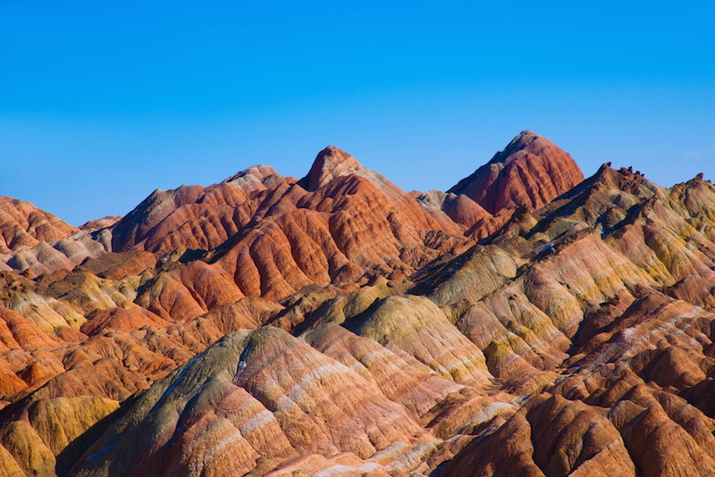
Rolling Thunder Mountain near Talus Lake is part of the Teton Range. The orange rock in the foreground is Webb Canyon gneiss, granite formed by decompression melting more than 2.6 billion years ago. Credit: Carol Frost

University of Wyoming scientists have found evidence of continental collisions in Wyoming’s Teton Range, similar to those in the Himalayas, dating to as early as 2.68 billion years ago.

The research, published Jan. 22 in the journal Geochimica et Cosmochimica Acta, shows that plate tectonics were operating in what is now western Wyoming long before the collisions that created the Himalayas starting 40 million years ago.

In fact, the remnants of tectonic activity in old rocks exposed in the Tetons point to the world’s earliest known continent-continent collision, says Professor Carol Frost of UW’s Department of Geology and Geophysics, lead author of the paper.

“While the Himalayas are the prime example of continent-continent collisions that take place due to plate tectonic motion today, our work suggests plate tectonics operated far, far back into the geologic past,” Frost says.

The paper’s co-authors include fellow UW Department of Geology and Geophysics faculty members Susan Swapp and Ron Frost.

The researchers reached their conclusions by analyzing ancient, exposed granite in the northern Teton Range and comparing it to similar rock in the Himalayas. The rocks were formed from magma produced by what is known as decompression melting, a process that commonly occurs when two continental tectonic plates collide. The dramatically thickened crust extends under gravitational forces, and melting results when deeper crust rises closer to the surface.

While the Tetons are a relatively young mountain range, formed by an uplift along the Teton Fault less than 9 million years ago, the rocks exposed there are some of the oldest found in North America.

The UW scientists found that the mechanisms that formed the granites of the Tetons and the Himalayas are comparable, but that there are significant differences between the rocks of the two regions. That is due to differences in the composition of the continental crust in Wyoming 2.68 billion years ago compared to crustal plates observed today. Specifically, the ancient crust that melted in the Tetons contained less potassium than the more recently melted crust found in the Himalayas.

The research was supported by the National Science Foundation.

Reference:
Carol D. Frost et al, Leucogranites of the Teton Range, Wyoming: A record of Archean collisional orogeny, Geochimica et Cosmochimica Acta (2015). DOI: 10.1016/j.gca.2015.12.015

Note: The above post is reprinted from materials provided by University of Wyoming.

Quest to drill into Earth’s mantle restarts

Jules Verne would have dug this plan: drill into the sea floor, through kilometres of the planet’s rocky crust to penetrate the denser underlying mantle. It is one of geology’s classic quests, conceived almost 60 years ago, at the peak of the plate-tectonics revolution. Since then, many have attempted it and failed. But an expedition starting this month is taking up the challenge once again.

In early December, the drill ship JOIDES Resolution will depart Colombo, Sri Lanka, and head for a spot in the southwestern Indian Ocean known as Atlantis Bank. There, it will lower a drill bit and try to screw it through 1.5 kilometres of rock, collecting a core sample as it goes. If all goes well, future expeditions — not yet scheduled or funded — will return and finalize the push into the mantle (see ‘Deep understanding’).

Normally, the crust–mantle boundary is thought to be marked by a feature known as the Mohorovičić discontinuity, or ‘Moho’, at which seismic waves change velocity. But at Atlantis Bank, the mantle is thought to bubble up as far as 2.5 kilometres above the Moho, making it easier to reach.
Reaching these deep-Earth frontiers “is one of the great scientific endeavours of the century”, says Henry Dick, a geophysicist at the Woods Hole Oceanographic Institution in Massachusetts and co-leader of the expedition.

Beneath continents, the Moho lies 30–60 kilometres down. But beneath oceans it is close enough to be reached with ship-borne drilling equipment. In the drilling campaign — dubbed the Slow Spreading Ridge Moho, or ‘SloMo’ Project — Dick hopes to reach the crust–mantle transition at Atlantis Bank, then one day return with a state-of-the-art Japanese vessel to reach the Moho itself at a depth of 5 kilometres or more. Along the way, scientists aim to answer profound questions about the planet, such as how molten rock rises from the interior and cools to form fresh ocean crust, a surface that blankets three-fifths of Earth.

Long-held dream

A hole that deep “would be the window into things we have never seen before”, says Benoît Ildefonse, a geologist at the University of Montpellier in France.

Scientists first tried to reach the Moho in the middle of the twentieth century. In the 1960s, US scientists led ‘Project Mohole’, which drilled into the sea floor off Guadalupe Island, Mexico. The project reached a depth of just 183 metres before costs ballooned and Congress killed it. Still, Project Mohole gave birth to a series of scientific ocean-drilling programmes that have extracted cores from hundreds of locations around the world. These have revolutionized Earth science by retrieving sedimentary records that date back millions of years, offering clues to how continents pull apart and finding microbial life deep beneath the sea floor.

“We live on this Earth and we ought to know something about what happens beneath us,” says Walter Munk, an oceanographer at the Scripps Institution of Oceanography in La Jolla, California, who conceived Project Mohole with colleagues over cocktails one evening in 1957. He is gratified by the success of scientific ocean drilling overall, but would still like to see the mantle breached.

Expeditions have come close before. Between 2002 and 2011, four holes at a site in the eastern Pacific managed to reach fine-grained, brittle rock that geologists believe to be cooled magma sitting just above the Moho. But the drill could not punch through those tenacious layers. And in 2013, drillers at the nearby Hess Deep found themselves similarly limited by tough deep-crustal rocks (K. M. Gillis et al. Nature 505, 204–207; 2014).

Dick and his colleagues are targeting the Indian Ocean ridge rather than the eastern Pacific because much smaller quantities of lava feed the sea floor there, so there is less hard rock to drill through. At Atlantis Bank, tectonic forces have lifted the sea floor to just 700 metres beneath the waves.

Dick knows that it is possible to reach his preliminary goal of 1.5 kilometres, because he has done it before. In 1997, he led an expedition to Atlantis Bank that got that deep before disaster struck: the pipe snapped off in high winds, corkscrewed down inside the hole and plugged it up. “We’re going to make sure that doesn’t happen this time,” he says.

Along the way, researchers hope to explore not just geology, but biology, too. Geological mapping suggests that seawater may have percolated several kilometres deep at Atlantis Bank, triggering chemical reactions that turn the rock into a type known as serpentinite. These reactions generate methane, a gas that sub-sea-floor microbes often munch for energy. JOIDES Resolution scientists will be checking the rock cores for microorganisms, says Virginia Edgcomb, a microbiologist at Woods Hole who will be on the cruise.

SloMo’s first phase runs until 30 January. If the drilling goes well, Dick hopes to return with the JOIDES Resolution to reach 3 kilometres. And after that, he and his colleagues hope to use the Japanese drill ship Chikyu in the project’s third phase to drill all the way to the Moho. Launched a decade ago, Chikyu was meant to drill to the Moho in the western Pacific, but technical challenges and a lack of funding means that has not happened yet. With a capacity to drill as deep as 6 kilo­metres, Chikyu could finally allow geologists to realize their almost 60-year old dream.

Note: The above post is reprinted from materials provided by Nature. The original article was written by Alexandra Witze.

Activity on seafloor linked to icy ebb and flow on surface

A UConn marine scientist has found that hydrothermal activity occurring along mid-ocean ridges like the one in this graphic may help explain why ice ages come and go. Credit: adapted from physicalgeography

The last million years of Earth’s history has been dominated by the cyclic advance and retreat of ice sheets over large swaths of North America, with ice ages occurring every 40,000 years or so.

While conventional wisdom says that this icy ebb and flow is an interaction between the water and atmosphere, the cause of the rapid transition between alternating cold glacial and warmer interglacial periods has been a mystery.

Until now. An article appearing in the Jan. 28 issue of the journal Science sheds new light on the role that the Earth itself may play in this climatological ballet.

UConn marine scientist David Lund and his colleagues studied hydrothermal activity along the mid-ocean ridge system – the longest mountain range in the world, which extends some 37,000 miles along the ocean floor – and found a link between pressure and temperature changes.

Their research suggests that the release of hot molten rock, or magma, from beneath the Earth’s crust in response to changes in sea level plays a significant role in the Earth’s climate by causing oceans to alternately warm and cool. This change in temperature is attributed to the release of heat and carbon dioxide (CO2) into the deep ocean.

During cold glacial intervals, ice sheets reached as far south as Long Island and Indiana, while during warm periods, the ice rapidly retreated to Greenland.

There is evidence that when ice sheets grow, sea level lowers and significant pressure is taken off the ocean ridges. But, as the pressure lessens, the mantle begins melting, which, in turn, warms the water and causes the ice to begin melting. Then, as the ice melts, sea levels rise, causing pressure on the mountain ranges to increase and activity within the mountain ranges to slow.

Think of the effect that applying pressure to a wound has in slowing the flow of bleeding.

The release of molten rock through volcanic vents or fissures is driven by seafloor spreading and decompression melting of the upper mantle, the partially molten layer just beneath the earth’s crust.

Well documented sedimentary records from the East Pacific Rise (EPR) – a mid-ocean ridge extending roughly from Antarctica to the Gulf of California – show evidence of increased hydrothermal activity at the ends of the last two glacial eras.

Researchers also examined core samples from the ocean floor mountain ridges and determined concentrations of major and trace elements.

The results establish the timing of hydrothermal anomalies. Says Lund, “Our results support the hypothesis that enhanced ridge magmatism [the release of molten rock through volcanic vents or fissures], hydrothermal output, and perhaps mantle CO2 flux act to reduce the size of ice sheets.”

Reference:
D. C. Lund et al. Enhanced East Pacific Rise hydrothermal activity during the last two glacial terminations, Science (2016). DOI: 10.1126/science.aad4296

Note: The above post is reprinted from materials provided by University of Connecticut.

Ionospheric anomalies – distinguishing quakes from storms

Maps showing VLF observation network operated by UEC. The geographic locations of VLF transmitters and receivers used for the data analysis are indicated. Corresponding great circle paths (GCPs) for every transmitter–receiver pair are also given. (a) Paths around Japan (indicating VLF receiving stations) and (b) entire paths (including VLF transmitters).

Research at the University of Electro-Communications suggests how to identify anomalies due to geomagnetic storms in low frequency signals, which may help distinguish them from seismic activity.
A potential for earthquake prediction may lie in detecting anomalies in the propagation of very low frequency (VLF: 3-30 kHz) radio signals, as they are greatly affected by ionospheric disturbances that may originate from seismic activity. However there are several other possible causes for VLF anomalies, including terrestrial and space weather, many of which are little understood. In their latest work the UEC researchers help to shed light on how to distinguish VLF anomalies caused by geomagnetic storms that have no relation to seismic activity.
The UEC researchers, Kenshin Tatsuta and Yasuhide Hobara, in collaboration with S. Pal, also associated with the Indian Centre for Space Physics and M. Balikhin at the University of Sheffield in UK, analysed data from 16–21 independent VLF and low-frequency transmitter-receiver paths at different latitudes over 27 months. The transmitter-receiver paths ran at high-latitude (east to west), mid-latitude (east to west) and north to south. They considered statistical parameters including the average signal amplitude and variability of the signal amplitude, and compared changes in the VLF propagation characteristics with data of geomagnetic storm indicators.

The comparisons indicated that VLF propagation is far more likely to exhibit anomalies caused by geomagnetic storms at high latitude than those at mid latitude or north-south transmitter-receiver paths, where anomalies originating from other events are more commonly observed. Paths over land rather than water may be also better for revealing anomalies with seismic origins due to the difference in conductivity.

The UEC team concludes, “Although it is still uncertain that only VLF data can be used to assess the probability of future seismic activities, the characteristics of VLF signals can form a part of the set of parameters that will allow us to provide a warning of possible hazards.”

Ionosphere

The ionosphere is located in the altitude between 60 km and 1000 km above sea level. Here solar radiation can ionize atoms and molecules. The density of atoms and molecules in this region is so low that although the ions and electrons created attract each other, they may still not readily recombine, giving rise to an ionic plasma.

Ionisation in the ionosphere is affected by solar intensity which varies over the course of the day and changes in seasons. As a result the composition of the ionosphere will vary diurnally and seasonally. It is also affected by space events, such as solar flares and geomagnetic storms, the Earth’s atmospheric weather such as thunderstorms, as well as seismic events.

Electromagnetic waves, such as from radio transmitters, interact with the ionosphere which affects the propagation characteristics, particularly electromagnetic signals at very low frequencies. How propagation is affected depends on the conductivity changes of the ionosphere along the propagation path. The challenge is distinguishing the signature of the different events that perturb the ionosphere in VLF signals to identify the cause.

Geomagnetic storms

The region in which the Earth’s magnetic field affects the paths of charged objects is described as the magnetosphere. Further away and the charged object may be more affected by the magnetic fields from other astronomical objects.

The electrically conducting plasma inside the Sun – solar wind – gives rise to its own magnetic field. A shock wave in solar wind can interact with the magnetosphere, initially compressing it and increasing its energy. This can increase electric field lines in the magnetosphere and electric currents in the magnetosphere and ionosphere.

Both the auroral electrojet and disturbance storm time indices are indicators of geomagnetic storms. The authors used measurements for both over the same time period to compare with the VLF propagation data.

The statistical parameters used

The daily average amplitude of the VLF transmitter signals used in this study was calculated by the average nighttime amplitude at a defined day. The residual so-called ‘trend’ at a defined day was then derived by the difference between the average nighttime amplitude at the defined day and the average amplitude over the previous 15 days .

The researchers specifically looked at the trend as well as the dispersion defined as the standard deviation of the residual each day and the nighttime fluctuation defined by the residual integrated over the whole night. These three statistical parameters considered may differ from study to study due to the different origins of perturbations and geographical configuration of the propagation paths, and the researchers will further study the effect of the VLF anomalies from different natural origins for comparison.

Reference:
K. Tatsuta et al. Sub-ionospheric VLF signal anomaly due to geomagnetic storms: a statistical study, Annales Geophysicae (2015). DOI: 10.5194/angeo-33-1457-2015

Note: The above post is reprinted from materials provided by University of Electro-Communications.

Ancient extinction of giant Australian bird points to humans

Ancient extinction of giant-GeologyPage
An illustration of a giant flightless bird known as Genyornis newtoni, surprised on her nest by a 1 ton, predatory lizard named Megalania prisca in Australia roughly 50,000 thousand years ago. Credit: Peter Trusler, Monash University

The first direct evidence that humans played a substantial role in the extinction of the huge, wondrous beasts inhabiting Australia some 50,000 years ago—in this case a 500-pound bird—has been discovered by a University of Colorado Boulder-led team.

The flightless bird, known as Genyornis newtoni, was nearly 7 feet tall and appears to have lived in much of Australia prior to the establishment of humans on the continent 50,000 years ago, said CU-Boulder Professor Gifford Miller. The evidence consists of diagnostic burn patterns on Genyornis eggshell fragments that indicate humans were collecting and cooking its eggs, thereby reducing the birds’ reproductive success.

“We consider this the first and only secure evidence that humans were directly preying on now-extinct Australian megafauna,” said Miller, associate director of CU-Boulder’s Institute of Arctic and Alpine Research. “We have documented these characteristically burned Genyornis eggshells at more than 200 sites across the continent.”

A paper on the subject appears online Jan. 29, in Nature Communications.

In analyzing unburned Genyornis eggshells from more than 2,000 localities across Australia, primarily from sand dunes where the ancient birds nested, several dating methods helped researchers determine that none were younger than about 45,000 years old. Burned eggshell fragments from more than 200 of those sites, some only partially blackened, suggest pieces were exposed to a wide range of temperatures, said Miller, a professor in CU-Boulder’s Department of Geological Sciences.

Optically stimulated luminescence dating, a method used to determine when quartz grains enclosing the eggshells were last exposed to sunlight, limits the time range of burned Genyornis eggshell to between 54,000 and 44,000 years ago. Radiocarbon dating indicated the burnt eggshell was no younger than about 47,000 years old.

The blackened fragments were likely burned in transient, human fires—presumably to cook the eggs—rather than in wildfires, he said.

Amino acids—the building blocks of proteins -decompose in a predictable fashion inside eggshells over time. In eggshell fragments burned at one end but not the other, there is a tell-tale “gradient” from total amino acid decomposition to minimal amino acid decomposition, he said. Such a gradient could only be produced by a localized heat source, likely an ember, and not from the sustained high heat produced regularly by wildfires on the continent both in the distant past and today.

Miller also said the researchers found many of the burnt Genyornis eggshell fragments in tight clusters less than 10 feet in diameter, with no other eggshell fragments nearby. Some individual fragments from the same clusters had heat gradient differences of nearly 1,000 degrees Fahrenheit, conditions virtually impossible to reproduce with natural wildfires there, he said.

“We can’t come up with a scenario that a wildfire could produce those tremendous gradients in heat,” Miller said. “We instead argue that the conditions are consistent with early humans harvesting Genyornis eggs, cooking them over fires, and then randomly discarding the eggshell fragments in and around their cooking fires.”

Another line of evidence for early human predation on Genyornis eggs is the presence of ancient, burned eggshells of emus—flightless birds weighing only about 100 pounds and which still exist in Australia today—in the sand dunes. Emu eggshells exhibiting burn patterns similar to Genyornis eggshells first appear on the landscape about 50,000 years ago, signaling they most likely were scorched after humans arrived in Australia, and are found fairly consistently to modern times, Miller said.

The Genyornis eggs are thought to have been roughly the size of a cantaloupe and weighed about 3.5 pounds, Miller said.

Genyornis roamed the Australian outback with an astonishing menagerie of other now-extinct megafauna that included a 1,000-pound kangaroo, a 2-ton wombat, a 25-foot-long-lizard, a 300-pound marsupial lion and a Volkswagen-sized tortoise. More than 85 percent of Australia’s mammals, birds and reptiles weighing over 100 pounds went extinct shortly after the arrival of the first humans.

The demise of the ancient megafauna in Australia (and on other continents, including North America) has been hotly debated for more than a century, swaying between human predation, climate change and a combination of both, said Miller. While some still hold fast to the climate change scenario—specifically the continental drying in Australia from about 60,000 to 40,000 years ago—neither the rate nor magnitude of that change was as severe as earlier climate shifts in Australia during the Pleistocene epoch, which lacked the punch required to knock off the megafauna, said Miller.

Miller and others suspect Australia’s first inhabitants traveled to the northern coast of the continent on rafts launched from Indonesian islands several hundred miles away. “We will never know the exact time window humans arrived on the continent,” he said. “But there is reliable evidence they were widely dispersed across the continent before 47,000 years ago.”

Evidence of Australia megafauna hunting is very difficult to find, in part because the megafauna there are so much older than New World megafauna and in part because fossil bones are easily destroyed by the chemistry of Australian soils. said Miller.

“In the Americas, early human predation on the giant animals in clear—stone spear heads are found embedded in mammoth bones, for example,” said Miller. “The lack of clear evidence regarding human predation on the Australia megafauna had, until now, been used to suggest no human-megafauna interactions occurred, despite evidence that most of the giant animals still roamed Australia when humans colonized the continent.”

Note: The above post is reprinted from materials provided by University of Colorado at Boulder.

UQ researcher’s icy dinosaur hunt

UQ researcher's icy-GeologyPage
Cape Lachman, James Ross Island – a dinosaur fossil site.

A University of Queensland scientist will brave ice, snow and five weeks sharing a two-man tent in an effort to learn more about dinosaurs during an expedition to Antarctica.

UQ School of Biological Sciences palaeontologist Dr Steve Salisbury will be among 12 scientists on an expedition running from 2 February to 24 March.

The seven palaeontologists, two sedimentologists, and three palaeontology graduate students will travel to the James Ross Island area— one of the few parts of Antarctica that has exposed rock during summer.

“We’re going down there to look for dinosaurs, but also other animals in Antarctica that may have existed towards the end of the Age of Dinosaurs,” Dr Salisbury said.

“Australia was connected to Antarctica right through the Age of Dinosaurs and beyond, up until about 40 million years ago.

“Antarctica holds the key to a lot of biogeographic problems that we’re trying unravel with regard to how dinosaurs and various other creatures ended up around the globe.”

Dr Salisbury said the team hoped to find new evidence that would indicate what dinosaurs may have existed in Australia, and how those already found in Australia might relate to their counterparts in Antarctica and other parts of once great southern supercontinent, Gondwana.

With a never-ending cycle of freezing and thawing, different areas are exposed each year, leaving potential for new discoveries.

“There could be skeletons exposed that weren’t seen before, that are just going to be sitting there on the ridges, I hope,” Dr Salisbury said.

“At first there will be a lot of walking around, kicking rocks, picking things up, looking for places to target and just systematically checking to see if anything new has appeared.”

The team has been preparing for the expedition since 2012, but significant sea ice over the past seasons has prevented their research ship from getting into the areas they need to target.

This time, the team will take two helicopters to ensure they can reach the areas they want to camp in unhindered.

“One of the biggest challenges is just getting there, and we don’t really know what we’re going to find, so you have to be prepared for everything,” Dr Salisbury said.

“We’ll have to bring a lot of specialist clothing, and we’ll have to set our camp up to be completely independent from the outside world for about four to five weeks.

“There’s a huge amount of logistics but I think that’s half the fun of operating somewhere like Antarctica.”

Video

Note: The above post is reprinted from materials provided by University of Queensland.

Related Articles