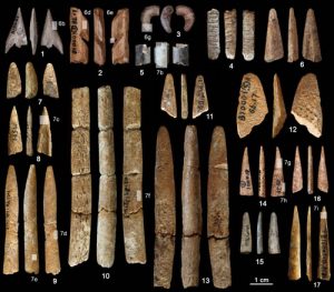
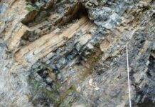
Fig. 1 Bone artefacts recovered from the Ma’anshan site Credit: ZHANG Shuangquan
The production of formal bone tools, defined as artefacts that were cut, carved, polished or otherwise modified to produce fully shaped points, awls, harpoons and wedges, appears relatively late in human history, and is only recorded at a handful of African sites prior to 45000 years ago. Early instances of bone technology in other areas of the Old World such as China, are however still rare, and those that are known are often insufficiently documented.
In a paper published in Journal of Archaeological Science in Janurary, a research team led by Dr. Gao Xing,Institute of Vertebrate Paleontology and Paleoanthropology (IVPP), Chinese Academy of Sciences, and Dr. Francesco d’Errico, Université de Bordeaux present their results of a techno-functional analysis of 17 bone tools recovered the Palaeolithic site of Ma’anshan Cave, Guizhou Province, southern China. These implements are the oldest formal bone tools from China, and the barbed points are amongst the oldest known outside Africa.
Ma’anshan Cave (106°49’37”E, 28°07’18”N ) is located 2 km southeast of Tongzi County, northwest Guizhou Province. The cave lies at an altitude of 960 m above sea level, and 40 m above the nearby Tianmen River. Excavations were systematically carried out in 1986 and 1990 by an IVPP team, and eight archaeological layers were clearly recognized.
The 17 formal bone tools were recovered from strata 6, 5 and 3 of the Palaeolithic site of Ma’anshan Cave. Stratum 6, dated to about 35000 years ago, has yielded three sharp awls. From Stratum 5, dated to about 34000 years ago, come six probable spear points, awls and a cutting tool. Separated from these layers by a sterile horizon, Stratum 3, dated about 23000 to 18000 years ago, has yielded barbed points of two types. Bone tools were shaped by scraping, grinding, and in strata 5 and 3, finished by polishing.
“Ma’anshan Cave records the oldest formal bone tools from China, and amongst the oldest known evidence of indisputable barbed point manufacture outside Africa”, said lead author Dr. ZHANG Shuangquan of the IVPP, “Change in the hunting toolkit between strata 5 and 3 may indicate a shift in prey preference from medium to small size mammals and fish, which needs to be verified by supplementary analyses. This finding provides new materials for studies about the origin of bone tool technology in Africa and Eurasia”.
“As at other sites from China, lithic technology at Ma’anshan remains relatively unchanged through time, our study demonstrates that bone tool technology shows rates of cultural turnover comparable to those observed in the Upper Palaeolithic of Europe”, said Dr. GAO Xing of the IVPP.
Reference:
Shuangquan Zhang et al. Ma’anshan cave and the origin of bone tool technology in China, Journal of Archaeological Science (2016). DOI: 10.1016/j.jas.2015.11.004
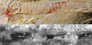
Complete specimen of Chengjiangocaris kunmingensis from the early Cambrian Xiaoshiba biota of South China. Bottom: Magnification of ventral nerve cord of Chengjiangocaris kunmingensis. Credit: Top: Jie Yang, Bottom: Yu Liu
Researchers have found one of the oldest and most detailed fossils of the central nervous system yet identified, from a crustacean-like animal that lived more than 500 million years ago. The fossil, from southern China, has been so well preserved that individual nerves are visible, the first time this level of detail has been observed in a fossil of this age.
The findings, published in the Proceedings of the National Academy of Sciences, are helping researchers understand how the nervous system of arthropods – creepy crawlies with jointed legs – evolved. Finding any fossilised soft tissue is rare, but this particular find, by researchers in the UK, China and Germany, represents the most detailed example of a preserved nervous system yet discovered.
The animal, called Chengjiangocaris kunmingensis, lived during the Cambrian ‘explosion’, a period of rapid evolutionary development about half a billion years ago when most major animal groups first appear in the fossil record. C. kunmingensis belongs to a group of animals called fuxianhuiids, and was an early ancestor of modern arthropods – the diverse group that includes insects, spiders and crustaceans.
“This is a unique glimpse into what the ancestral nervous system looked like,” said study co-author Dr Javier Ortega-Hernández, of the University of Cambridge’s Department of Zoology. “It’s the most complete example of a central nervous system from the Cambrian period.”
Over the past five years, researchers have identified partially-fossilised nervous systems in several different species from the period, but these have mostly been fossilised brains. And in most of those specimens, the fossils only preserved details of the profile of the brain, meaning the amount of information available has been limited.
C. kunmingensis looked like a sort of crustacean, with a broad, almost heart-shaped head shield, and a long body with pairs of legs of varying sizes. Through careful preparation of the fossils, which involved chipping away the surrounding rock with a fine needle, the researchers were able to view not only the hard parts of the body, but fossilised soft tissue as well.
The vast majority of fossils we have are mostly bone and other hard body parts such as teeth or exoskeletons. Since the nervous system and soft tissues are essentially made of fatty-like substances, finding them preserved as fossils is extremely rare. The researchers behind this study first identified a fossilised central nervous system in 2013, but the new material has allowed them to investigate the significance of these finding in much greater depth.
The central nervous system coordinates all neural and motor functions. In vertebrates, it consists of the brain and spinal cord, but in arthropods it consists of a condensed brain and a chain-like series of interconnected masses of nervous tissue called ganglia that resemble a string of beads.
Like modern arthropods, C. kunmingensis had a nerve cord – which is analogous to a spinal cord in vertebrates – running throughout its body, with each one of the bead-like ganglia controlling a single pair of walking legs.
Closer examination of the exceptionally preserved ganglia revealed dozens of spindly fibres, each measuring about five thousandths of a millimetre in length. “These delicate fibres displayed a highly regular distribution pattern, and so we wanted to figure out if they were made of the same material as the ganglia that form the nerve cord,” said Ortega-Hernández. “Using fluorescence microscopy, we confirmed that the fibres were in fact individual nerves, fossilised as carbon films, offering an unprecedented level of detail. These fossils greatly improve our understanding of how the nervous system evolved.”
For Ortega-Hernández and his colleagues, a key question is what this discovery tells us about the evolution of early animals, since the nervous system contains so much information. Further analysis revealed that some aspects of the nervous system in C. kunmingensis appear to be structured similar to that of modern priapulids (penis worms) and onychophorans (velvet worms), with regularly-spaced nerves coming out from the ventral nerve cord.
In contrast, these dozens of nerves have been lost independently in the tardigrades (water bears) and modern arthropods, suggesting that simplification played an important role in the evolution of the nervous system.
Possibly one of the most striking implications of the study is that the exceptionally preserved nerve cord of C. kunmingensis represents a unique structure that is otherwise unknown in living organisms. The specimen demonstrates the unique contribution of the fossil record towards understanding the early evolution of animals during the Cambrian period. “The more of these fossils we find, the more we will be able to understand how the nervous system – and how early animals – evolved,” said Ortega-Hernández.
Reference:
Jie Yang et. al. The fuxianhuiid ventral nerve cord and early nervous system evolution in Panarthropoda. PNAS, 2016 DOI: 10.1073/pnas.1522434113
Note: The above post is reprinted from materials provided by University of Cambridge. The original story is licensed under a Creative Commons License.
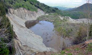
Head of the West Salt Creek rock avalanche near the end of the 2015 spring snowmelt season. The sag pond was nearly full, with a water-level rise of less than 1 m needed for water to begin to spill over the rock-slide slump block. On 25 May 2014, movement of the rock-slide slump block mobilized the rock avalanche that traveled down the West Salt Creek valley. Rock falls and rock slides from headscarp are ongoing. Ongoing threats to areas downstream include: a large rock slide from the headscarp into the sag pond, another failure of the rock-slide slump block, a rapid release of water from the sag pond, and rapid or slow movement of the avalanche deposit (shown in Photo 2). The maximum height of the active headscarp on the left is ~100 m. View is to the northwest toward the town of Collbran, Colorado. Photo taken by Jeff Coe on 7 June 2015.
On 25 May 2014, a rain-on-snow-induced rock avalanche occurred in the West Salt Creek valley on the northern flank of Grand Mesa in western Colorado (United States). The avalanche mobilized from a preexisting rock slide in the Green River Formation and traveled 4.6 km down the confined valley, killing three people.
The 54.5 million cubic meter slide traveled those 4.6 km in about 3.5 minutes, with average velocities ranging up to 36 meters per second. The mobility of the avalanche was likely enhanced by liquefied valley-floor sediment.
This type and size of avalanche happens only rarely in the United States. To study the dynamics of the avalanche, Jeffrey A. Coe and colleagues from the U.S. Geological Survey used a novel combination of large-scale field mapping, unmanned aerial system (UAS) imagery, eyewitness accounts, and data from seismic stations located at distances up to 650 km away from the avalanche.
Their research shows that the avalanche had a complex series of movement phases, starting with a cascade of landslide/debris flow beginning about 10 hours before the catastrophic rock slide-avalanche phases, and ending with rock slides and rock falls from an oversteepened headscarp. These rock slides and rock falls are ongoing.
The results of this study can be applied to rock avalanche modeling and warning, monitoring of ongoing hazards at the site, and interpreting the emplacement velocity of paleo-landslide deposits.
Reference:
Rock-avalanche dynamics revealed by large-scale field mapping and seismic signals at a highly mobile avalanche in the West Salt Creek valley, western Colorado GEOSPHERE (2016). DOI: 10.1130/GES01265.1
“Without compressibility and gravity, we cannot describe low-frequency sound waves correctly,” Usama Kadri says. “This is one of the reasons why researchers have mostly overlooked acoustic-gravity waves.” Credit: Christine Daniloff/MIT
Acoustic-gravity waves are very long sound waves that cut through the deep ocean at the speed of sound. These lightning-quick currents can sweep up water, nutrients, salts, and any other particles in their wake, at any water depth. They are typically triggered by violent events in the ocean, including underwater earthquakes, explosions, landslides, and even meteorites, and they carry information about these events around the world in a matter of minutes.
Researchers at MIT have now identified a less dramatic though far more pervasive source of acoustic-gravity waves: surface ocean waves, such as those that can be seen from a beach or the deck of a boat. These waves, known as surface-gravity waves, do not travel nearly as fast, far, or deep as acoustic-gravity waves, yet under the right conditions, they can generate the powerful, fast-moving, and low-frequency sound waves.
The researchers have developed a general theory that connects gravity waves and acoustic waves. They found that when two surface-gravity waves, heading toward each other, are oscillating at a similar but not identical frequency, their interaction can release up to 95 percent of their initial energy in the form of an acoustic wave, which in turn carries this energy and travels much faster and deeper.
This interaction may occur anywhere in the ocean, in particular in regions where surface-gravity waves interact as they reflect from continental shelf breaks, where the deep-sea suddenly faces a much shallower shoreline.
Usama Kadri, a visiting assistant professor and a research affiliate in MIT’s Department of Mathematics, says the team’s results establish a concrete and detailed relationship between surface-gravity waves and acoustic-gravity waves, which, until now, scientists had suspected did not exist. Understanding this relationship, he says, allows researchers to describe how energy is exchanged between gravity and acoustic waves. He says this energy could be vital for many marine life forms, and it could play a role in water transport and the redistribution of carbon dioxide and heat to deeper waters, thereby sustaining a healthy marine environment.
Kadri and his colleague, Triantaphyllos Akylas, a professor of mechanical engineering at MIT, have published their results in the Journal of Fluid Mechanics.
Adjusting for the real world
For the most part, gravity waves and acoustic waves have been regarded as completely separate entities, one having no effect on the other. That’s because their properties are so different, in both length and timescales. While gravity is the main force acting to restore and stabilize surface-gravity waves (hence the name), its effect on sound waves is negligible. On the other hand, the fact that water is slightly compressible is what allows pressure waves, such as sound, to travel through, though this property has almost no effect on surface waves.
Kadri says the typical water wave equations used to characterize ocean wave interactions do not apply to acoustic-gravity waves, as they do not factor in compressibility and gravity effects.
“Without compressibility and gravity, we cannot describe low-frequency sound waves correctly,” Kadri says. “This is one of the reasons why researchers have mostly overlooked acoustic-gravity waves.”
Kadri derived a wave equation that includes compressibility and gravity as well as higher-order nonlinear terms.
“In linear theory, two surface-gravity waves traveling toward each other do not feel each other; they get closer, pass each other, and then move away without exchanging any form of energy, as if they have never met,” Kadri explains. “However, in reality the picture is more complicated, and nonlinear effects may come into play, resulting in energy exchange and even generation of new waves, sometimes. Here, at specific frequency ranges, gravity waves can actually produce an acoustic wave that has completely different properties — and that is amazing.”
Rolling in the deep
The newly derived wave equation allowed Kadri to study the behavior of both acoustic and gravity waves. He analyzed the theoretical interactions within a wave triad consisting of two surface-gravity waves and one acoustic-gravity wave. In 2013, he proved numerically that this configuration of waves should resonate, or exchange energy, meaning that as two of the three waves oscillate, they should drive the third wave to oscillate in response. Now, using the modified wave equation, along with multiple scales analysis, he derived what are called “evolution equations” to describe how the amplitudes of all three waves change as they exchange energy.
Surprisingly, he calculated that if two surface waves flow toward each other at roughly the same frequency and amplitude, as they meet and roll through each other the majority of their energy — up to 95 percent — can be turned into a sound wave, or acoustic-gravity wave. This energy can fluctuate, depending on the initial amplitudes and frequencies of the surface-gravity waves. Even when the surface-gravity waves travel in the form of short bursts, they can still transfer over 20 percent of their energy to acoustic-gravity waves, an amount that cannot be neglected.
“This is incredible, just to think that these waves are so different,” Kadri says. “Having them sharing energy is really exciting; this explains how some of the energy that comes from the atmosphere, from the sun and the wind, to the upper part of the ocean, can actually be driven to roll in the deep ocean through acoustic-gravity waves.”
Kadri says the results may help scientists connect interactions between not only surface and deep ocean waters, but also with the atmospheric forces that affect surface waves.
Now Kadri is imparting this new understanding of wave interactions to a critical application: tsunami detection. He is working with the Woods Hole Oceanographic Institution to design a system to detect acoustic-gravity waves that precede a tsunami, traveling more than 10 times as fast as the more destructive wave.
“Severe sea states, such as tsunamis, rogue waves, storms, landslides, and even meteorite fall, can all generate acoustic-gravity waves,” Kadri says. “We hope we can use these waves to set an early alarm for severe sea states in general and tsunamis in particular, and potentially save lives.”
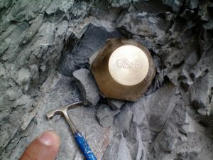
Golden spike emplaced in bed that is Global Standard Stratotype Section and Point (GSSP) for the Thenetian Stage. Length of “rock hammer”: 5 cm. Credit: Stan Finney and Lucy Edwards; GSA Today
In the March-April issue of GSA Today, Stanley Finney (California State University at Long Beach) and Lucy Edwards (U.S. Geological Survey) tackle the hot topic of whether to define a new “Anthropocene” epoch as a formal unit of the geologic time scale. The term “Anthropocene” has receive significant coverage in both the geoscience and popular press, but little of that coverage has focused on how units of the International Chronostratigraphic Chart (the basis for the geologic time scale) are defined.
Finney and Edwards use this opportunity to explain to the general geoscience audience the criteria for stratigraphic units within the International Stratigraphic Guide, and how decisions are made to define new units or change existing units.
As such, this informative article provides general geologic information that goes beyond the hot topic itself. In the article’s conclusion, the authors do not pronounce judgment on whether a new Anthropocene epoch should be created, but rather encourage the geologic community to educate themselves on how stratigraphic units are defined and then contribute to the ongoing discussion.
Reference:
The: “Anthropocene” epoch: Scientific decision or political statement? Stanley C. Finney, Dept. of Geological Sciences, California State University, Long Beach, California 90277, USA; and Lucy E. Edwards, U.S. Geological Survey, Reston, Virginia 20192, USA. GSA Today, v. 26, no. 3-4, p. 4-10, DOI: 10.1130/GSATG270A.1
This 1.30 ct Fancy brownish greenish yellow diamond contains an octahedral-shaped inclusion. Credit: Jian Xin (Jae) Liao.
Primary diamond deposits are usually found in mantle-derived igneous rocks, with the principal hosts being kimberlite and lamproite. During the ascent to the earth’s surface, diamonds may be converted, partially or entirely, to graphite and chemically dispersed and eliminated (A.A. Snelling, “Diamonds – Evidence of explosive geological processes,” Creation, Vol. 16, No. 1, 1993, pp. 42–45). GIA’s New York laboratory recently received a 1.30 ct Fancy brownish greenish yellow diamond (figure 1) containing an octahedral-shaped inclusion outlined by minute crystal inclusions along the junctions of the crystal faces.
Gemological examination at 60× magnification reveals that the octahedral-shaped inclusion is outlined by numerous irregular dark crystals (figure 2). Advanced gemological analysis with UV-Vis and FTIR spectroscopy confirmed that this was a natural diamond with a natural color origin.
Further analysis using Raman spectroscopy reveals that the dark inclusions are graphite crystals with a Raman peak at 1590 cm–1 (figure 3), which corresponds to the graphite G band (I. Childres et al., “Raman spectroscopy of graphene and related materials,” in J.I. Jang, Ed., New Developments in Photon and Materials Research, Nova Science Publications, 2013).
Since this G band is at a slightly higher energy level than that from the primary graphite, which usually peaks at around 1580 cm–1, we propose that the crystals tested are likely the secondary graphite converted from part of the original diamond into graphite form during the specific growth episode when oxidized fluids rich in CO2 and H2O passed through diamond bearing horizons.
This also explains the shift of the G band to a higher energy, due to the higher strain near these newly formed secondary graphite crystals (J. Hodkiewitcz, “Characterizing graphene with Raman spectroscopy,” Application Note: 51946, Thermo Fisher Scientific, Madison, Wisconsin, 2010). Late formation of additional diamond layers on top of the graphites would have converted them to covered internal features within the larger diamond (R.H. Mitchell, Kimberlites and Lamproites: Primary Sources of Diamond, Geoscience Canada Reprint Series 6, Vol. 18, No. 1, 1991, pp. 1–16).
Primary graphite crystals could also mix into the crystal clouds during the diamond’s growth due to changes in environmental temperature, pressure, and the growth fluid’s chemical elements. These minute graphite crystals would tend to form along the junctions of crystal faces, since they usually have a higher surface energy. Thus, we believe that both primary and secondary graphite formation, occurring between the diamond’s growth episodes, contributed to this phenomenal octahedral outline.
Graphite inclusions are commonly seen in diamonds as isolated crystals or jointed crystal clouds. It is very unusual to see these minute graphite inclusions formed at the junctions of the original diamond crystal faces and outlining the octahedral growth pattern. This stone not only captures the amount of stress and extreme conditions under which the diamond grew, but also shows the beauty of the formation of crystalline diamond.
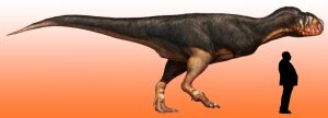
Fossil find reveals just how big carnivorous dinosaur may have grown. Credit: Image courtesy of Imperial College London
An unidentified fossilised bone in a museum has revealed the size of a fearsome abelisaur and may have solved a hundred-year old puzzle.
Alessandro Chiarenza, a PhD student from Imperial College London, last year stumbled across a fossilised femur bone, left forgotten in a drawer, during his visit to the Museum of Geology and Palaeontology in Palermo Italy. He and a colleague Andrea Cau, a researcher from the University of Bologna, got permission from the museum to analyse the femur. They discovered that the bone was from a dinosaur called abelisaur, which roamed the Earth around 95 million years ago during the late Cretaceous period.
Abelisauridae were a group of predatory, carnivorous dinosaurs, characterised by extremely small forelimbs, a short deep face, small razor sharp teeth, and powerful muscular hind limbs. Scientists suspect they were also covered in fluffy feathers. The abelisaur in today’s study would have lived in North Africa, which at that time was a lush savannah criss-crossed by rivers and mangrove swamps. This ancient tropical world would have provided the abelisaur with an ideal habitat for hunting aquatic animals like turtles, crocodiles, large fish and other dinosaurs.
By studying the bone, the team deduced that this abelisaur may have been nine metres long and weighed between one and two tonnes, making it potentially one of the largest abelisaurs ever found. This is helping researchers to determine the maximum sizes that these dinosaurs may have reached during their peak.
Alfio Alessandro Chiarenza, co-author of the study from the Department of Earth Science and Engineering at Imperial, said: “Smaller abelisaur fossils have been previously found by palaeontologists, but this find shows how truly huge these flesh eating predators had become. Their appearance may have looked a bit odd as they were probably covered in feathers with tiny, useless forelimbs, but make no mistake they were fearsome killers in their time.”
The fossil originated from a sedimentary outcrop in Morocco called the Kem Kem Beds, which are well known for the unusual abundance of giant predatory dinosaur fossils. This phenomenon is called Stromer’s Riddle, in honour the German palaeontologist Ernst Stromer, who first identified this abundance in 1912. Since then scientists have been asking how abelisaurs and five other groupings of predatory dinosaurs could have co-existed in this region at the same time, without hunting each other into extinction.
Now the researchers in today’s study suggest that these predatory dinosaur groups may not have co-existed so closely together. They believe that the harsh and changing geology of the region mixed the fossil fragment records together, destroying its chronological ordering in the Kem Kem beds, and giving the illusion that the abelisaurs and their predatory cousins shared the same terrain at the same time. Similar studies of fossil beds in nearby Tunisia, for example, show that creatures like abelisaurs were inland hunters, while other predators like the fish eating spinosaurs probably lived near mangroves and rivers.
Chiarenza added: “This fossil find, along with the accumulated wealth of previous studies, is helping to solve the question of whether abelisaurs may have co-existed with a range of other predators in the same region. Rather than sharing the same environment, which the jumbled up fossil records may be leading us to believe, we think these creatures probably lived far away from one another in different types of environments.”
Fossilised femora are useful for palaeontologists to study because they can determine the overall size of the dinosaur. This is because femora are attached to the thigh and tail muscles and have scars, or bumps, which tell palaeontologists where the ligaments and muscles were attached to the bone and how big those muscles and ligaments would have been.
Andrea Cau, co-author from the University of Bologna, said: “While palaeontologists usually venture to remote and inaccessible locations, like the deserts of Mongolia or the Badlands of Montana, our study shows how museums still play an important role in preserving specimens of primary scientific value, in which sometimes the most unexpected surprises can be discovered. As Stephen Gould, an influential palaeontologist and evolutionary biologist, once said, sometimes the greatest discoveries are made in museum drawers.”
The study is published today in the journal Peer J. Chiarenza did the underpinning analysis with Cau while at the University of Bologna.
The next step will see the team looking for more complete remains from these predatory dinosaurs trying to better understand their environment and evolutionary history.
Reference:
Alfio Alessandro Chiarenza, Andrea Cau. A large abelisaurid (Dinosauria, Theropoda) from Morocco and comments on the Cenomanian theropods from North Africa. PeerJ, 2016; 4: e1754 DOI: 10.7717/peerj.1754
Note: The above post is reprinted from materials provided by Imperial College London. The original item was written by Colin Smith.
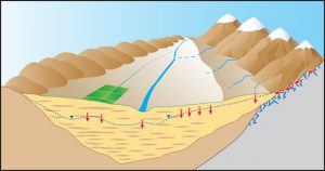
This graphic shows various ways that water can reach and recharge a groundwater aquifer: precipitation that percolates directly down into the aquifer; recharge from streams or runoff; water that percolates deep into the soil as a result of crop irrigation; and recharge from melting snowpack and from mountain streams that flow into the valley below. Credit: David Stonestrom/U.S. Geological Survey
By 2050, climate change will increase the groundwater deficit even more for four economically important aquifers in the Western U.S., reports a University of Arizona-led team of scientists.
The new report is the first to integrate scientists’ knowledge about groundwater in the American West with scientific models that show how climate change will affect the region.
“We wanted to know, ‘What are the expectations for increases and decreases in groundwater as we go forward in this century?'” said lead author Thomas Meixner, a UA professor and associate department head of hydrology and water resources. “In the West, 40 percent of the water comes directly from groundwater.”
Climate models predict that, in general, wet regions will become wetter and dry regions will become drier. The Southwest is expected to become drier and hotter.
“Aquifers in the southern tier of the West are all expected to see slight-to-significant decreases in recharge as the climate warms,” Meixner said.
Groundwater already is being withdrawn from the aquifers of California’s Central Valley, the central and southern portions of the High Plains and Arizona’s San Pedro faster than the groundwater is being recharged.
Climate change will make the groundwater deficits worse in those aquifers, the researchers report.
For the Death Valley and Wasatch Front aquifers, the effect of climate change on the balance between usage and recharge isn’t so predictable.
In contrast, Western aquifers at about the latitude of Boulder, Colorado, and farther north are likely to be recharged faster than people withdraw the water, the team reports. The northern aquifers the researchers studied are the northern High Plains, the Spokane Valley, the Williston Basin and the Columbia Plateau.
“In the long term, pumping has to equal recharge. You can get there through slow social adjustment. You could slowly decrease water withdrawal by conservation and efficiency,” Meixner said. “Or you can hit bottom and have farm abandonment and dry wells.
“It’s a social decision as to who gets the water,” he said. “The southern regions of the Western U.S. must be prepared to adapt to a much drier future.”
The team’s research article, “Implications of projected climate change for groundwater recharge in the Western United States,” and scheduled for publication in the March issue of the Journal of Hydrology. Christopher Castro, UA associate professor of atmospheric sciences, is a co-author.
The report is an outgrowth of a workshop held at the U.S. Geological Survey’s John Wesley Powell Center for Analysis and Synthesis. The National Science Foundation and USGS funded the workshop.
To synthesize existing knowledge and predict how climate change would affect Western groundwater, Meixner gathered 16 experts in climate change and in hydrology of the Western U.S.
Predictions at the major river basin or several-state level can be useful for developing water policy, the team wrote. However, the team found predictions from existing studies were either at a global scale or at the local level, not at the regional level.
To create regional-scale predications, the scientists synthesized existing studies and applied current knowledge of recharge processes. The team studied eight economically important Western aquifers for which studies about their groundwater recharge budgets existed. In addition, models of how climate change would affect recharge were available for four of the aquifers.
To compare all eight aquifers, the team developed a uniform classification scheme for the components of groundwater recharge. The scientists identified four different components of groundwater recharge: diffuse, focused, irrigation and mountain system.
Some types of recharge are more easily affected by human behavior and water policy than others. Human decision-making can easily affect irrigation recharge (water that percolates deep into the soil from irrigating crops) and focused recharge (water that reaches the groundwater from streams or runoff).
In contrast, human behavior has a much smaller effect on diffuse and mountain-systems recharge. Diffuse recharge comes from the precipitation that falls on a specific spot and then percolates down into the groundwater.
Much of the mountain-systems recharge comes from snowpack, Meixner said. As the snow melts, the water fills mountain streams that end up in the flatlands below. Snowmelt also can percolate into the soil and eventually reach the valley below as the water moves downhill through the bedrock underlying the mountains.
The San Pedro aquifer in southeastern Arizona is one example of an aquifer where the human use of groundwater will increasingly outstrip recharge as the climate warms, the researchers report. Much of the San Pedro’s current recharge comes from mountain-system recharge, which the scientists expect will dwindle as more precipitation falls in the mountains as rain rather than snow and as the region dries.
When more groundwater is pumped than is replaced by recharge, rivers can be sucked dry, as happened to the Santa Cruz River in Tucson, Meixner said. Once the Santa Cruz flowed year-round; now in Tucson the river has water only after heavy rains.
“What you would expect to see is that climate change will exacerbate problems in the Southwest on the recharge end,” Meixner said.
“Our study reveals that the Western U.S. needs to redouble efforts to manage water resources to maximize benefits to individuals and society,” he said. “We can’t be wasting water.”
Reference:
Thomas Meixner, Andrew H. Manning, David A. Stonestrom, Diana M. Allen, Hoori Ajami, Kyle W. Blasch, Andrea E. Brookfield, Christopher L. Castro, Jordan F. Clark, David J. Gochis, Alan L. Flint, Kirstin L. Neff, Rewati Niraula, Matthew Rodell, Bridget R. Scanlon, Kamini Singha, Michelle A. Walvoord, Implications of projected climate change for groundwater recharge in the western United States. DOI:10.1016/j.jhydrol.2015.12.027
Paleontologists in Argentina have announced the discovery of a major Jurassic-era fossil site four years after it was first discovered.
The site, which spans 23,000 square miles (60,000 square kilometers) in Patagonia, southern Argentina, came to light this week with the publication of a report in the journal Ameghiniana.
“No other place in the world contains the same amount and diversity of Jurassic fossils,” said geologist Juan Garcia Massini of the Regional Center for Scientific Research and Technology Transfer (CRILAR).
The fossils—between 140 and 160 million years old—lie on the surface because they were recently exposed by erosion, said Garcia Massini, who leads the research team investigating the site.
“You can see the landscape as it appeared in the Jurassic—how thermal waters, lakes and streams as well as plants and other parts of the ecosystem were distributed,” he said.
The fossils were preserved almost immediately, in less than a day in some cases.
“You can see how fungi, cyanobacteria and worms moved when they were alive,” Garcia Massini said of the site that lies along the Deseado Massif mountain range.
Ignacio Escapa of the Egidio Feruglio Paleontology Museum said the researchers had found “a wide range of micro and macro-organisms.”
The fossils are so well preserved, that researchers say each rock extracted from the site could possibly open the door to a new discovery.
Note: The above post is reprinted from materials provided by AFP.
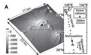
A: Bathymetry of Nisihinoshima, Japan, before A.D. 2013 eruption. Credit: Fukashi Maeno et al/., Geology, and Japan Science and Technology Agency. TerraSAR-X images copyright 2014. DLR, Distribution Airbus DS/Infoterra GmbH, Sub-Distribution [PASCO].On Nov. 20, 2013, the Japan Maritime Self-Defense Force discovered a small islet near Nishinoshima volcano, Ogasawara Islands, Japan. The exact date of the initial eruption that spawned the islet is unknown, but a thermal anomaly was detected in the area in early November 2013. Fukashi Maeno and colleagues are investigating the creation of this islet, which on the day of its discovery was about 150 by 80 meters in size.Volcanic eruptions in water environments (“Surtseyan eruptions”) can result in the production of new islets like this one. However, the entire sequence of such eruptions is rarely observed. Therefore, discovery of the islet so close to the eruption date provides a rare opportunity to learn how a volcanic island is created.
On Nov. 21, 2013, Maeno and colleagues carried out aircraft observations of the area and confirmed the Surtseyan eruptions, which within three days changed to Strombolian eruptions, because a pyroclastic cone formed around the vent and prevented external water from flowing into the crater.
The most intriguing characteristic of the lava flows, say Maeno and colleagues, was the development of a large number of lobes and tubes. Internal pathways that fed lava to the active flow front were eventually developed and dominated the lava transport. The effects of the lava’s contact with seawater as well as the variations in the lava discharge rate on the local and overall scales are also important factors affecting the lava transport system.
A Florida State University student has cracked the code to reveal the deep and interesting history of an ancient meteorite that likely formed at the time our planets were just developing.
Jonathan Oulton, a 2015 FSU graduate, working with Earth, Ocean & Atmospheric Science Professor Munir Humayun, studied the pieces of a meteorite called Gujba. Using sophisticated lasers and mass spectrometers at the FSU-headquartered National High Magnetic Field Laboratory, Humayun and Oulton conducted in-depth chemical analysis of the meteorite samples that shattered previous theories about when and how this meteorite had formed.
“We tried to elucidate a story about its origins through this science,” said Oulton, who is now pursuing a doctoral degree at University of Colorado.
Previously, scientists believed that Gujba was formed more or less from the dust of the solar system.
But, as Humayun and Oulton analyzed it, they discovered it had a far more complex geological history than previously thought. They inferred that Gujba formed from the debris of a collision between a parent planet that had both a crust and mantle, something that would only be found on a fairly large planet of the kind that is not seen today in the asteroid belt.
To get that type of formation, Gujba would have been involved in more than the equivalent of a solar system fender bender.
Oulton, Humayun and their collaborators argue that Gujba formed from the molten debris produced when a large metallic body smashed into another planet and both bodies were destroyed in the process. Based on chemical traces preserved in Gujba, the target planet might have been even larger than the asteroid 4 Vesta, one of the largest bodies in the asteroid belt with a diameter of about 326 miles or 525 kilometers.
“People used to say that meteorites like Gujba were the building blocks of the solar system,” Humayun said. “Now, we know it’s the construction debris of the planets, to borrow a phrase from Ed Scott of the University of Hawaii.”
The research will be published in an upcoming issue of Geochimica et Cosmochimica Acta, but is currently available online.
Oulton presented the preliminary results of the paper at the 2015 Lunar & Planetary Science Conference and received the Dwornik Award of the Geological Society of America for the best undergraduate presentation.
“In a broad sense, people have been trying forever to understand how we got here,” Oulton said. “Although this doesn’t get to that directly, this research gives us a greater understanding of the physical chemistry of everything that occurred at the time the Earth formed.”
Oulton served as the lead author on the article. Other researchers on the paper are Lawrence Grossman and Alexei Fedkin of The University of Chicago.
Reference:
Chemical evidence for differentiation, evaporation and recondensation from silicate clasts in Gujba. Jonathan Oulton, Munir Humayun, Alexei Fedkin, Lawrence Grossman. DOI:10.1016/j.gca.2016.01.008
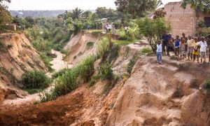
The erosion of large natural channels by flowing water—gully erosion—can wreak havoc on fields, roads, and buildings. In some cases, the sudden expansion of gullies even claims human lives. Geographers from KU Leuven, Belgium, are the first to show a worldwide link between heavy rainfall and the speed at which gullies expand. With predicted climate change, gullies may erode up to three times faster.
Researchers Matthias Vanmaercke and Jean Poesen from the Division of Geography and Tourism joined forces with an international team to collect and analyse measurements from 26 countries all over the world. Their study shows that rainfall has a much bigger impact on gully erosion than was previously assumed.
“We already knew that gullies can suddenly expand significantly during heavy rainfall”, says Matthias Vanmaercke. “In a tropical area, a gully can sometimes grow up to 100 metres in length due to one downpour. This may have serious consequences in populated areas. Our study is the first to provide exact numbers. The model that we developed shows that even relatively small changes in rainfall intensity can have major consequences for gully expansion.”
This process comes with challenges. “A widely accepted climate projection predicts that rainfall intensities will increase in most regions worldwide”, Vanmaercke continues. “Gully expansion rates could double in Western Europe and the US, where rainfall intensity is expected to go up by 10 to 15% by 2060. In regions such as Ethiopia, gully erosion rates may even triple. This would not only have a detrimental effect on agriculture and water quality, but could also entail problems such as muddy floods and the destruction of roads and other infrastructure.”
The good news is that gully erosion can often be stopped. This study is an important step in the right direction, as the proposed model and the data collected make it possible to better predict the expansion of gullies. As a result, more adequate measures can be taken in terms of soil and water conservation practices.
Chimpanzees have an ancient common ancestor—or genetic ‘Adam’—that lived over one million years ago, according to University of Leicester geneticists.
In a study, which was funded by the Wellcome Trust and published in the journal Genome Research, the research team led by Professor Mark Jobling from the University of Leicester’s Department of Genetics determined the DNA sequences of a large part of the Y chromosome, passed exclusively from fathers to sons, in a set of chimpanzees, bonobos, gorillas and orangutans.
The study also looked at mitochondrial DNA (mtDNA), passed from mothers to offspring, in the same set of animals.
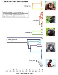
This allowed the construction of genealogical trees that could be compared between species and subspecies – and helped the researchers to discover that the genetic ‘Adam’ for chimpanzees lived a remarkable one million years ago.
Dr Pille Hallast from the Department of Genetics, lead author on the paper, explained: “The ancestor of a Y-chromosome family tree is sometimes called ‘Y-chromosomal Adam’. We can compare the ages of ‘Adams’ between the species. For humans the age is about 200 thousand years, while for gorillas it’s only about 100 thousand years. Thanks to two chimps in our sample, Tommy and Moritz, chimpanzees have an amazingly ancient ‘Adam’, who lived over 1 million years ago.
“The Y chromosome tree for gorillas is very shallow, which fits with the idea that very few male gorillas (alpha males) father the offspring within groups. By contrast, the trees in chimpanzees and bonobos are very deep, which fits with the idea that males and females mate with each other more indiscriminately.”
The project’s leader, Professor Mark Jobling from the University of Leicester’s Department of Genetics, added: “It’s interesting to compare the shapes of the trees between humans and our great-ape relatives. Considering both Y chromosome and mitochondrial DNA trees, humans look much more like gorillas than chimps.
“This suggests that over the long period of human evolution our choice of partners has not been a free-for-all, and that it’s likely that humans have practiced a polygynous system – where a few men have access to most of the women, and many men don’t have access – over our evolutionary history as a species. This is more like the gorilla system than the chimpanzee ‘multimale-multifemale’ mating system.”
Reference:
Pille Hallast et al. Great-ape Y-Chromosome and mitochondrial DNA phylogenies reflect sub-species structure and patterns of mating and dispersal, Genome Research (2016). DOI: 10.1101/gr.198754.115
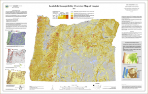
Landslide susceptibility overview map of Oregon, scale 1:750,000. View Large map Credit: OREGON DEPARTMENT OF GEOLOGY AND MINERAL INDUSTRIES
A new landslide susceptibility map of Oregon helps identify regions of the state that may be at risk for future landslides.
“Oregon is prone to landslides,” says Bill Burns, engineering geologist for the Oregon Department of Geology and Mineral Industries (DOGAMI). “This map points us toward priority areas for future in-depth mapping and study of our landslide hazards, and helps Oregonians better understand the potential hazard in their own communities.”
More than a third of Oregon’s land has very high or high landslide susceptibility. Very high susceptibility means the area is an existing landslide; high susceptibility means landsliding is likely. Landslides can be triggered by factors such as intense rainfall, rapid snow melt, and freeze/thaw cycles. In some areas of the state, particularly western Oregon, very high and high susceptibility percentages are much higher. Read the full report: bit.ly/1KHY2yZ
The mapping marks the first time since 1982, when the U.S. Geological Survey published a landslide overview map of the United States, that there’s been a look at the landslide susceptibility of the entire state. The accompanying report includes susceptibility percentages for all Oregon counties, incorporated cities, and some watersheds.
A 2013 Clackamas County landslide hazard and risk study is an example of the type of detailed study that Burns says is critical for Oregon’s landslide-susceptible locations. In that study, DOGAMI identified 2,885 existing landslides, on top of which are $1 billion worth of buildings and land with almost 8,000 people.
“Studying landslides helps Oregon understand where taking action might decrease the risk to people, buildings and infrastructure,” Burns says.
The new landslide hazard information can also help Oregonians protect themselves and their property. Knowing which areas may be susceptible to landslides helps people identify places to avoid during extreme weather, and helps people determine whether hiring a geotechnical professional to evaluate their property may be necessary. The new mapping has been added to SLIDO, DOGAMI’s interactive landslide hazard map: bit.ly/oregonslido.
Map
Reference:
DOGAMI Open-File Report O-16-02, Landslide Susceptibility Overview Map of Oregon by William J. Burns, Katherine A. Mickelson, and Ian P. Madin contains a map, report and GIS data.Download this publication for free at bit.ly/1KHY2yZ
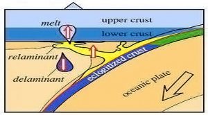
Deep beneath Alaska’s Aleutian Islands, down where the pressure and temperatures have become so high that rock starts to flow, new continental crust is being born.
Scientists have long believed that continental crust forms in volcanic arcs – they know the magma brought up in the arcs’ volcanoes is geochemically very similar to continental crust. The lingering question has been how exactly that happens. While the magma that reaches the surface is similar to continental crust, the lower crust beneath volcanic arcs is quite different from the lower half of continental crust.
A new study appearing in this week’s Nature Geoscience raises questions about one popular theory and provides new support for another, in which arc lava from the surface and shallow “plutons” – magma that solidified without erupting – are pulled down into the Earth at subduction zones and then rise up to accumulate at the bottom of the arc crust like steam on a kitchen ceiling. Scientists have found compelling evidence to suggest that this could have produced the vast majority of lower continental crust through Earth history.
The process, called relamination, starts at the edge of a continental plate, where an oceanic plate is diving under the continental plate and magma is rising to form a volcanic arc. As the oceanic plate dives, it drags down sediment, lava and plutonic rock from the edge of the arc. As arc material descends, minerals within it become unstable with the rising pressure and heat, and they undergo chemical changes. New minerals form, and chunks of the rock and sediment can break off. When those chunks are denser than the mantle rock around them, they continue to sink. But when they are less dense, such as those that form silica-rich granulites, they become buoyant and float upward until they reach the bottom of the arc crust and accumulate there.
“Sediments are really well represented in continental lower crust, but how did they get on to the bottom of the continent? The easiest way is for that sediment to be pushed down a subduction zone and rise to accumulate at the base of the crust,” said Peter Kelemen, a geochemist at Columbia University’s Lamont-Doherty Earth Observatory and author of the paper with Mark Behn of Woods Hole Oceanographic Institution.
Sampling the Earth’s Crust
To determine how arc crust could turn into continental crust, Kelemen and Behn examined the only two known sites where a complete section of arc lower crust is visible on land. One site, in Pakistan, had been caught in the ancient collision of tectonic plates between India and Asia, and was thrust up into steep mountains. The other, the Talkeetna arc stretching from the Alaska Peninsula to Valdez, was pushed up at the edge of North America.
“We don’t usually get to see the bottoms of arc lower crust, but in Alaska and Pakistan we can see right down to the bottom. These old arcs formed, crashed into North America, turned on their sides, and were eroded over millions of years. Because they’re tilted, we can walk right down from the seafloor, past the base of the crust and into the mantle,” Kelemen said.
Along the length of these areas of exposed arc crust, the scientists took samples to see how the geochemical composition of the rock changed with increasing depth in the crust. They were able to extract minerals that had recorded the pressure and temperature at the point where the minerals crystalized deep underground, marking how deep the rock was at each point.
The scientists found significant changes in the crustal composition about half way down into the arc crust.
In the lower half of the arc crust, starting about 20 kilometers below the original surface, the average concentration of “incompatible” trace elements – elements like tantalum and potassium that prefer to remain in melt during crystallization – was much less than in lower continental crust at the same depth. It was only the upper 20 kilometers of the arc crust that had compositions similar to lower continental crust.
That becomes a problem for one leading theory of how continental crust forms, Kelemen said. That theory suggests that the arc crust delaminates – dense bits of rock within the arc crust slowly move downward and “founder” into the mantle until the arc crust attains the composition of continental crust. The new data suggests that for delamination to work would require removing much of the rock from a 20-kilometer thickness of crust. However, delamination only works below 35 to 40 km depth.
“So, even after we remove a bit of dense stuff off the bottom, you’re still going to end up with lower crust in the arcs that looks really different from lower crust in the continents. The process isn’t sufficient to make continental lower crust out of arc crust,” Kelemen said. Delamination does take place, but for it to be the driving force would require a complex process of repeated crustal thickening and metamorphic events, he said.
Kelemen and Behn suggest a simpler process.
The Aleutian Islands Test
The authors put their model to the test on the Aleutian Islands. In that volcanic arc, the lava and plutons are similar to continental crust, but the lower crust is highly depleted in elements that are abundant in lower continental crust. To determine the potential for relamination to produce lower continental crust, the scientists calculated the density of the exposed lava and plutons at subduction zone pressures and temperatures.
About 44 percent of the Aleutian lavas and 78 percent of the plutons would be more buoyant than mantle peridotite under subduction zone conditions, they found. This suggests that if parts of the Aleutian arc are pulled down into the subduction zone, at a depth of 90 to 120 km, where temperatures exceed 700°C, the arc lavas and plutons would rise to accumulate along the bottom of the crust. The composition of this accumulated material would look like lower continental crust.
Intrigued by that finding, the scientists performed the same calculations for other arcs. They found that at the Alaska Talkeetna site, 48 percent of lavas and 37 percent of plutons would be buoyant. At Kohistan, the site in Pakistan, 36 percent of lavas and 29 percent of plutons would be buoyant.
Relamination may be evident in Southern California’s Pelona Schist where sections of lower continental crust are visible, Kelemen said. Clay rocks and blobs of mantle peridotite surrounded by more buoyant materials can be found in the exposed, “underplated” crust.
“We can see young, volcanic sediments that were stuffed under older continental crust and are now part of the overall package. How did they get down there? It happened in Southern California, and I would argue it probably happens in a lot of places,” Kelemen said.
Reference:
Peter B. Kelemen et al. Formation of lower continental crust by relamination of buoyant arc lavas and plutons, Nature Geoscience (2016). DOI: 10.1038/ngeo2662
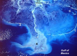
The Mississippi River Delta from the Space Shuttle Discovery in 1985. Credit: NASA
From the Yellow River in China to the Mississippi River in Louisiana, researchers are racing to better understand and mitigate the degradation of some of the world’s most important river deltas, according to a University of Colorado Boulder faculty member.
CU-Boulder Professor James Syvitski said more than two-thirds of the the world’s 33 major deltas are sinking and the vast majority of those have experienced flooding in recent years, primarily a result of human activity. Some 500 million people live on river deltas around the world, a number that continues to climb as the population increases.
“These deltas are starved of the sediments they need for stability because of upstream dams that trap the material,” said Syvitski, a professor in geological sciences who also is executive director of the international Community Surface Dynamics Modeling System (CSDMS) which is based in Boulder. “We are seeing coastal erosion increasing in many places across the planet.”
Human effects on river deltas range from engineering tributaries and river channels, extracting groundwater and fossil fuels, trapping sediments behind dams, reducing peak flows of rivers and varied agricultural practices, he said.
Syvitski presented new research findings on changing deltas around the world at the 2016 Ocean Sciences meeting held in New Orleans Feb. 21-26, 2016.
River deltas are land areas created by sediment that collects at the mouths of rivers as they enter slow-moving or standing water like oceans and estuaries. “Deltas are sinking at a much greater rate than sea levels are rising,” Syvitski said.
One positive action was taken on the 3,395-mile-long Yellow River recently when some major dams were flushed of their sediments and sent rushing downstream, said Syvitski. “This might be the first time that dam operators on the Yellow River have worked with people in the coastal zone to solve a problem.”
But looming threats to the Yellow River Delta include the sinking, or subsidence of land caused in large part by a move from rice farming to aquaculture—raising fish and shrimp, he said. The land in some areas there is sinking by 10 inches per year as groundwater is pumped to the surface.
“The rate of subsidence there is amazingly high—the ground can sink 3 feet in 4 years and affect infrastructure like buildings and roads,” Syvitski said. “But more importantly, lowering the land surface makes it much more exposed to the ocean environment, including storm surges from hurricanes and tsunamis.”
The two major river deltas in the United States are the Mississippi River Delta in Louisiana and the Sacramento-San Joaquin River Delta in California. While the Sacramento-Joaquin Delta has significant issues with agricultural, industrial and urban pollution and subsidence, things are more dire in the Mississippi River Delta, where a football field-sized chunk of wetlands disappears every hour, said Syvitski. There are more than 40,000 dams 20 feet or higher on the Mississippi River system.
The Community Surface Dynamics Model System is a global, interdisciplinary program involving hundreds of researchers and students now in 500 institutes in 68 countries. Cross-disciplinary research groups develop integrated software modules that predict the movement of water, sediment and nutrients across landscapes and into the oceans. Major funding for CSDMS comes from the National Science Foundation.
“We are interested in how landscapes and seascapes change over time, and how materials like water, sediments and nutrients are transported from one place to another,” he said. “The CSDMS effort gives us a better understanding of Earth and allows us to make better predictions about areas at risk to phenomena like flooding, deforestation, forest fires, land-use changes and the impacts of climate change.”
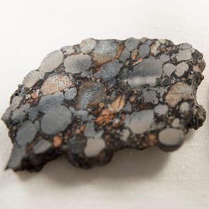
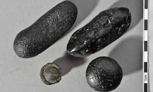
Tektites of different shapes from Australia. The force of the impact hurled the glass bodies thousands of kilometres. Some left the earth’s atmosphere and acquired their flanged edge on re-entry into the atmosphere (bottom left). Credit: Institute of Earth Sciences, Heidelberg University
Approximately 790,000 years ago, there were multiple cosmic impacts on earth with global consequences. Geoscientists from Heidelberg University reached this conclusion after dating so-called tektites from various parts of the world. The research group under the direction of Prof. Dr. Mario Trieloff studied several of such rock glasses, which originated during impacts of asteroids or comets.
The Heidelberg scientists employed a dating method based on naturally occurring isotopes that allowed them to date the tektites more accurately than ever. Their studies show that the samples from Asia, Australia, Canada and Central America are virtually identical in age, although in some cases their chemistry differs markedly. This points to separate impacts that must have occurred around the same time. The results of their research funded by the Klaus Tschira Foundation were published in the journal Geochimica et Cosmochimica Acta.
The research group at the Institute of Earth Sciences and the Klaus Tschira Laboratory for Cosmochemistry uses isotope measurements to determine the age of craters caused by the impact of extraterrestrial rocks. “That’s how we know when, where and how often projectiles struck the earth, and how big they were,” says Mario Trieloff. There have long been signs that a major event of this type took place on earth about a million years ago, according to Prof. Trieloff. This is evidenced by tektites, so-called rock glasses that arise during impact, whereby terrestrial material melts, is hurled up to several hundred kilometres and then hardens into glass.
“We have known about such tektites for some time from the Australasian region,” explains Dr. Winfried Schwarz, the study’s primary author. These rock glasses form a strewn field that stretches from Indochina to the southernmost tip of Australia. Smaller tektites, known as microtektites, were also discovered in deep-sea drill cores off the coast of Madagascar and in the Antarctic. The rock glasses had been strewn over 10,000 kilometres, with some of them even leaving the earth’s atmosphere. Using the 40Ar-39Ar dating method, which analyses the decay of the naturally occurring 40K isotope, the Heidelberg researchers succeeded in dating these tektites more accurately than ever before.
“Our data analysis indicates that there must have been a cosmic impact about 793,000 years ago, give or take 8,000 years,” explains Winfried Schwarz. The Heidelberg scientists also studied samples from Canada and Central America. The Canadian rock glasses had the same chemical composition and age as the Australasian tektites and could have covered similar “flight routes” as objects found in southern Australia or the Antarctic. Other finds must first confirm whether the recovery sites are really where the tektites originally landed or whether they for example were carried there by people, according to Dr. Schwarz.
The rock glasses from Central America are also tektites – the first specimens were found at Mayan sites of worship. In the meantime, hundreds of other finds have been made in Central America. “These tektites are clearly different in their chemical composition, and their geographical distribution also shows that they come from separate impacts,” explains Dr. Schwarz. “Surprisingly our age estimates prove that they originated 777,000 years ago with a deviation of 16,000 years. Within the error margin, this matches the age of the Australasian tektites.”
These findings led the Heidelberg researchers to conclude that there were multiple cosmic impacts approximately 790,000 years ago. In addition to the events in the Australasian and Central American regions, a smaller collision at around the same time created the Darwin crater in Tasmania. “The distribution of the tektites and the size of the strewn field indicate that the earth-striking body was at least a kilometre in size and released an impressive one million megatons of TNT energy within seconds of impact,” explains Dr. Schwarz.
According to the scientists, the consequences were dire. At the local level, there was fire and earthquakes for hundreds of kilometres surrounding the impact site; an ocean impact would have caused tsunamis hundreds of metres high. At the global level, dust and gases were ejected into the upper levels of the atmosphere, blocking sunlight and lowering surface temperatures. Biomass production was also affected, although according to the scientists it did not result in global mass extinction as in the case of the dinosaurs approximately 65 million years ago.
Reference:
Winfried H. Schwarz et al. Coeval ages of Australasian, Central American and Western Canadian tektites reveal multiple impacts 790ka ago, Geochimica et Cosmochimica Acta (2016). DOI: 10.1016/j.gca.2015.12.037
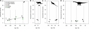
Total subsampled palaeocontinential diversity (A), and individually for mammals (B), herps (C; non-mammalian, non-dinosaurian tetrapods), and dinosaurs (D)
Tetrapod is the name given to any vertebrate animal with four (tetra) legs (pod). There are more than 30,000 living species of tetrapod known today, and this includes many of the animals we are familiar with like mammals, crocodiles, snakes, and birds. The question of how they reached this level of diversity is still very much open, and we know that by peering back into pre-history with the fossil record the number of tetrapod species has not remained constant through time.
The history of tetrapod life is punctuated by episodes of mass extinction, huge reorganisations of life both in terms of ecology and the relative dominance of different groups. With extinction comes radiation, the origin of new groups to fill the vacant environments and ecologies left as species die out. This natural variation in the fluctuating number of species through time is inconsistent through time, and unlocking what drives such patterns remains one of the long standing, but well-investigated, realms of palaeontological research.
The importance of why we research such things might not be immediately clear, but there are two main reasons that come to mind:
Understanding the evolution of life on this planet is a totally awesome thing to study;
By learning about past patterns and processes in the history of life, we might better understand how to stop destroying it so much in the future.
Recently, we have been able to provide some answers to the questions of how diverse through time has life been, based on the building of large fossil occurrence databases and new methods of analysing them. One such development has been the Paleobiology Database, a professional crowd-sourced archive of fossil history, where the context of fossils is provided in both space and time, and largely based on the published record of fossil discoveries.
Unfortunately, simply counting the number of species preserved through time as fossils is not a good way of measuring biodiversity: we can’t simply say we have n species found in this time period, and therefore diversity was n. The reasons for this are due to differences in how the fossil record is preserved through time, and presented to us as collectors and researchers. For example, what do you do if you have a lot of fossiliferous rock in one time period, but very little in another, and does an absence of fossil-bearing rock imply low diversity or something else? Or how do you compare samples if you have 100 fossil occurrences representing 20 species in one time bin, but 150 occurrences representing 50 species in another? This is the fundamental problem with the evenness of sampling, which is sometimes called ‘sampling bias’, and has plagued palaeontologists since the day someone was kind enough to point it out.
However, this problem, as with all of those in science, is not completely intractable! Thankfully, there exist a whole suite of methods to counter this issue of sampling variation. One of the more recently implemented of these is one called Shareholder Quorum Subsampling (SQS) developed by John Alroy, the statistical sensei of palaeontology. It has a horrific name, yes, but SQS is essentially a method that weights how diverse one species is (the shareholder) based on its frequency of occurrence. Using this, and a calculation taken from ecology of how evenly sampled your overall sample is, you can then count through repeated random trials (subsampling) until a pre-defined threshold (the quorum; you see where this is going now..) applied to all samples is met. If that doesn’t make sense, don’t worry about it – it took me years to understand and implement this method, and that was only with the help of John himself (who, incidentally, is an author on the paper this post is all about!)
By applying SQS with our development of large fossil occurrence datasets, voila, we are able to gain renewed insight into the diversity of life through history in a way that accounts for the inherent biases of the fossil record!
And that’s just what a new study in PLOS Biology set out to do. Led by Roger Benson of the University of Oxford, an international team of researchers applied SQS to one of the largest tetrapod fossil occurrence databases ever assembled (if not the largest!), comprising more than 27,000 individual fossil occurrences! This represented almost 5000 fossil species, and the data were restricted to just those fossils that dwelled on land – so this excludes groups like ichthyosaurs and plesiosaurs, for example. They also excluded flying tetrapods, so birds, bats and mammals, as these are known to have very different preservational histories in the fossil record. For palaeontology though, this is definitely ‘big data’.
The team restricted their analyses to just the Mesozoic to early Paleogene, a time span of around 190 million years (a fairly long time, even by geological standards!). If you think about it, that’s 5000 species over about 190 million years, which compared to 30,000 around today is pretty weird even in itself.
But anyway, armed with this hefty dataset, it becomes possible to group them by the time at which they occur in the fossil record, and use SQS to assess how their diversity changes through time. Simples?
What did they find? Well, perhaps a quite unexpected result. They found that tetrapod diversity actually remained fairly constant and stable throughout most of this time period. This was in spite of the fact that we have new groups originating and diversifying, such as mammals, amphibians, and dinosaurs, while other groups go extinct or massively reduce in numbers. In all, species diversity of non-flying mammals increased less than double, which suggests that there is some suppressing or limiting factor that controls long term diversification in tetrapods.
Interestingly, the extent of sampling bias detected varied substantially on a regional level, based on approximate palaeocontinental reconstructions (the world was a very different place 100 million years ago!) What this means is that global diversity counts, when applying techniques like SQS, are poor reflectors of what is happening to diversity at a regional level through time.
The team also found an anomaly at the end-Cretaceous mass extinction, with a four-fold expansion of species diversity following the extinction, suggesting that this extinction was highly important in paving the way for the origins of modern biodiversity. This result does not seem to be due to the aforementioned geographical biases, and instead appears to be almost entirely due to an explosive radiation of mammals subsequent to the extinction event. This led to an almost total restructuring of pre-extinction terrestrial ecosystems, and ultimately led to what is commonly referred to as ‘the rise of the mammals’. Sorry dinosaurs!
However, Benson and colleagues to advise caution in interpreting this as a genuine evolutionary phenomenon. This is because mammalian species are much more easily identifiable based on the remains of teeth, and therefore part of this apparent increase in diversity after the extinction event might simply be due to changes in how vertebrate discovery and taxonomy works.
Overall, the results obtained in the study show that tetrapod diversity throughout the Mesozoic less than doubled when sampling issues are accounted for. This in turn implies a very low, near-zero rate of diversification through time. Such a discovery is highly at odds with previous analyses which either accounted for sampling issues in different ways or ignored them entirely, which suggested that tetrapod diversity actually was unconstrained and rapidly increased on land throughout the Mesozoic.
The reasons for why this pattern exists though are more complicated. It is difficult to tell whether it is due to the achievement of a diversity equilibrium, where extinction rates and rates of diversification balance each other out, a phenomenon often referred to as ‘diversity dependence’, or perhaps simply due to overall stability in environments throughout the Mesozoic. The result of both of these hypotheses would be static diversity through time. Alternatively, it could be something a little more exciting, where we have a scenario in which diversifications are largely unconstrained, but regulated by more frequent episodes of extinction or dramatic reductions in diversification rates. So, in short, it’s a bit of a mess and quite difficult to tell.
This is already a rather long post, and could go on forever about the cool results obtained in the Benson et al. study. So I’ll end with a couple of key points:
The fossil record is our gateway to understanding the patterns and processes regulating past diversity, and remains key to understanding the origins and future of modern biodiversity;
Mesozoic tetrapod faunas appear to have been relatively stable when regional sampling biases are accounted for, and document very low diversification rates;
Palaeontology has never been more relevant in helping us to understand the evolution of life, and we’re making huge leaps forward in terms of data and methods to realise this.
Reference:
Roger B. J. Benson et al. Near-Stasis in the Long-Term Diversification of Mesozoic Tetrapods, PLOS Biology (2016). DOI: 10.1371/journal.pbio.1002359
Antarctica’s glaciers are the size of the United States and Mexico combined, and they contain enough water to raise the world’s sea level by 180 feet. Credit: Ralph Timmermann/Alfred Wegener Institute
In the early Miocene Epoch, temperatures were 10 degrees warmer and ocean levels were 50 feet higher — well above the ground level of modern-day New York, Tokyo and Berlin.
It was more than 16 million years ago, so times were different. But there was one important similarity with the world we live in today: The air contained about the same amount of carbon dioxide. That parallel raises serious concerns about the stability of ice sheets in Antarctica, according to a study published today in the Proceedings of the National Academy of Sciences.
All told, Antarctica’s glaciers are the size of the United States and Mexico combined, and they contain enough water to raise the world’s sea level by 180 feet. And although no humans live permanently in Antarctica, what happens there impacts everyone, said Aradhna Tripati, a geochemist at UCLA’s Institute of the Environment and Sustainability who collaborated on the research.
“The ice sheets serve as huge stores of water,” Tripati said. “As the ice melts, it gets dumped in the ocean and the sea level rises.”
The study is the latest revelation of ANDRILL, a $20 million research project focused on the South Pole. The effort, now 12 years old, has involved 100 researchers from seven countries. ANDRILL researchers were the first to bore holes through Antarctic ice shelves and sea ice to sample the ocean floor below.
Previous research showed that ice shelves — the parts of the ice sheets that extend over water — are vulnerable to even small increases in greenhouse gases. But the new study, which was written by Richard Levy of GNS Science, a New Zealand research organization, was the first to demonstrate that the huge, land-based glaciers are also vulnerable.
David Harwood, a University of Nebraska paleontologist who led the study, said the project’s goal was to see what prehistoric environments could tell us about the modern era of climate change.
“We’re drilling back into the past to understand the future and how dynamic our planet can be,” he said.
To do that, researchers set 90 tons worth of drilling equipment on a floating sea ice in McMurdo Sound, where conditions can be particularly harsh: The average August temperature is minus 23 degrees Fahrenheit, and savage windstorms can occur at a moment’s notice. Using a diamond-tipped tubular drill, researchers bored through 24 feet of ice, 1,200 feet of water and 3,300 feet of ocean floor. The rock samples they collected preserve a chronological record of environmental conditions dating back 20 million years.
The samples were sent to Tripati for analysis. As she looked at the sedimentary layers, a story began to emerge. Samples that were formed during warmer times, when the ice shelf was gone or unstable, were tan-colored and rich with fossils. But samples drawn from years when the sea was covered with ice, were mostly rock with fossils from only a few deep sea organisms.
Looking even closer, Tripati examined individual molecules from the samples to determine air and water temperatures at different times in history. Warmer times correlated with higher levels of carbon dioxide in the atmosphere, melting ice shelves and the loss of parts of the East Antarctic ice sheet.
According to Tripati, scientists are seeing early signs of the same conditions today.
“If carbon dioxide is sustained at current levels, we run the risk of Antarctic ice shelf disappearance,” she said.
The ice shelves are critical because they act like a cork in a Champagne bottle, holding back the huge, land-based flows of glacial ice on the Antarctic continent, Tripati said. But they are particularly sensitive to temperature changes. Just a few degrees of increased warmth can make them disappear because they are warmed by both the air and the sea.
And disappearing ice shelves lead to even more warming because of something called the albedo effect: Light-colored ice reflects the sun’s radiation away from Earth. After it melts, the darker-colored seas absorb more radiation and more heat.
That process could take hundreds of years, but signs of rapid change are already here. In 2002, the Larsen B ice shelf — which was made up of more than 1,250 square miles of 720-foot-thick ice — disintegrated into the ocean over the course of a month, shocking scientists and observers. Over the past several decades, seven out of 12 ice shelves on the Antarctic Peninsula have collapsed.
“They’ve just been going like dominoes,” Tripati said.
Still, researchers say the PNAS findings offer a glimmer of hope. Policymakers rely on computer models to predict future climate change, and the models now can be refined based on the new information about changes that occurred millions of years ago, Tripati said.
The big question that remains is how fast melting will occur. Harwood said the ANDRILL findings emphasize the fragility of ice shelves and the urgency of taking action on a global scale.
“The models simulate thresholds, points of no return,” he said. “It’s good for policymakers to know how fast we have to get off this train or turn it in a new direction.”
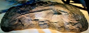
A 90-million-year-old fossil fish, currently on display at the Perot Museum of Nature and Science in Dallas, turns out to be a new species. Research conducted by Kenshu Shimada, Ph.D., professor at DePaul University and research associate of the Sternberg Museum, reveals the 5.5-foot-long fossil fish to possess a tuna-like body with a unique ‘hook-shaped sail’ on its back. The fish’s new species name, Pentanogmius fritschi, is in honor of local amateur collector Joseph Fritsch. Credit: Photo by Kenshu Shimada, Ph.D.
A 90-million-year-old fossil fish, which has been on display at the Perot Museum of Nature and Science in Dallas, turns out to be a new species. Research conducted by Kenshu Shimada, Ph.D., professor at DePaul University in Chicago and research associate of the Sternberg Museum in Kansas, reveals the 5.5-foot-long fossil fish to possess a tuna-like body with a unique ‘hook-shaped sail’ on its back. The fish has been given a new species name, Pentanogmius fritschi, in honor of Joseph Fritsch, a local amateur collector who discovered the fossil, dug it up with the help of another avid fossil collector, Kris Howe, and donated it to the Perot Museum.
“At first glance, the specimen looked like a known Pentanogmius species, but when I began to trace the curved dorsal fin, its front half kept extending backwards far beyond where I thought it would end relative to its rear half. That’s when I realized I have something new to science,” said Dr. Shimada.
The fossil fish is a nearly complete skeleton from the Britton Formation of the Eagle Ford Shale in Dallas County. Dr. Shimada’s study suggests that Pentanogmius fritschi was an active fish in open ocean environments that possibly fed on a variety of small animals like squid and other fish.
Besides its scientific significance, the new study is a success story demonstrating the very function of a collection-based museum and collaboration between amateur fossil collectors and scientists. Anthony Fiorillo, Ph.D., a paleontologist and the Perot Museum’s vice president of research and collections and chief curator, took notice of the remarkable preservation of the fossil fish soon after its discovery. He worked with Fritsch and Howe to make the specimen available to the public and to the scientific community during the developmental stage of the Museum.
Fiorillo had worked closely with Howe years earlier when Howe donated a fossil he unearthed in Grapevine, Texas. Dr. Fiorillo and another Perot Museum paleontologist Ronald Tykoski, Ph.D., determined that the fossil remains represented North America’s oldest fossil bird. They named it Flexomornis howei in Howe’s honor. The fossil is currently on view in the Museum’s Rose Hall of Birds.
“We’re very excited by the discovery of this new fossil fish for two reasons. First, it once again illustrates that the Perot Museum of Nature and Science not only inspires but serves as a resource for those in our community curious about the natural world around them,” said Dr. Fiorillo. “Secondly, this find also demonstrates the dynamic nature of scientific investigation within our T. Boone Pickens Life Then & Now Hall.”
The Museum opened in 2012, but it was not until Dr. Shimada’s visit in 2014 that the fish was found to be new to science. His resulting study — entitled “A new species of the Late Cretaceous ‘sail-finned’ bony fish, Pentanogmius (Actinopterygii: Tselfatiiformes), from Texas, USA” — will appear in a forthcoming issue of the international scientific journal Cretaceous Research.
“The really great thing about this fish is that it was found right here in Dallas County,” said Fritsch, who lives in Carrollton. “People are led to believe that fossils are found in exotic locations not accessible to the general public. The reality is North Texas is full of fossil hunting opportunity for anyone willing to go out and enjoy a walk in nature.”
Reference:
Kenshu Shimada. A new species of the Late Cretaceous ‘sail-finned’ bony fish, Pentanogmius (Actinopterygii: Tselfatiiformes), from Texas, USA. Cretaceous Research, 2016; 61: 188 DOI: 10.1016/j.cretres.2015.12.019