Home Blog Page 178

Rosetta’s comet contains ingredients for life

Rosetta’s comet contains-GeologyPage
Rosetta’s comet in August 2015, when it was closest to the sun and when most of the glycine was detected. Credit: ESA

Ingredients crucial for the origin of life on Earth, including the simple amino acid glycine and phosphorus, key components of DNA and cell membranes, have been discovered at Comet 67P/Churyumov-Gerasimenko.

The possibility that water and organic molecules were brought to the early Earth through impacts of objects like asteroids and comets have long been the subject of important debate.

While Rosetta’s ROSINA instrument already showed a significant difference in composition between Comet 67P/C-G’s water and that of Earth, the same instrument has now shown that even if comets did not play as big a role in delivering water as once thought, they certainly had the potential to deliver life’s ingredients.

While more than 140 different molecules have already been identified in the interstellar medium, amino acids could not be traced. However, hints of the amino acid glycine, a biologically important organic compound commonly found in proteins, were found during NASA’s Stardust mission that flew by Comet Wild 2 in 2004, but terrestrial contamination of the collected dust samples during the analysis could not be ruled out. Now, for the first time, repeated detections at a comet have been confirmed by Rosetta in Comet 67P/C-G’s fuzzy atmosphere, or coma.

The first detection was made in October 2014, while most measurements were taken during the perihelion in August 2015 — the closest point to the Sun along the comet’s orbit while the outgassing was strongest. “This is the first unambiguous detection of glycine in the thin atmosphere of a comet,” says Kathrin Altwegg, principal investigator of the ROSINA instrument at the Center of Space and Habitability of the University of Bern and lead author of the study. The results are now being published in Science.

Primordial chemistry in the ice
Glycine is very hard to detect due to its non-reactive nature: it sublimates at slightly below 150°C, meaning that little is released as gas from the comet’s surface or subsurface due to its cold temperatures. “We see a strong correlation of glycine to dust, suggesting that it is probably released from the grains’ icy mantles once they have warmed up in the coma, perhaps together with other volatiles,” says Altwegg. At the same time, the researchers also detected the organic molecules methylamine and ethylamine, which are precursors to forming glycine. Unlike other amino acids, glycine is the only one that has been shown to be able to form without liquid water. “The simultaneous presence of methylamine and ethylamine, and the correlation between dust and glycine, also hints at how the glycine was formed,” says Altwegg.

Phosphorus, a key element for terrestrial life
Another exciting detection by ROSINA made for the first time at a comet is of phosphorus. It is a key element in all living organisms and is found in the structural framework of DNA and RNA.

“The multitude of organic molecules already identified by ROSINA, now joined by the exciting confirmation of fundamental ingredients like glycine and phosphorus, confirms our idea that comets have the potential to deliver key molecules for prebiotic chemistry,” says Matt Taylor, Rosetta project scientist of the European Space Agency ESA. “Demonstrating that comets are reservoirs of primitive material in the Solar System, and vessels that could have transported these vital ingredients to Earth, is one of the key goals of the Rosetta mission, and we are delighted with this result.”


Reference:
K. Altwegg, H. Balsiger, A. Bar-Nun, J.-J. Berthelier, A. Bieler, P. Bochsler, C. Briois, U. Calmonte, M. Combi, H. Cottin, J. De Keyser, F. Dhooghe, B. Fiethe, S. A. Fuselier, S. Gasc, T. I. Gombosi, K. C. Hansen, M. Hässig, A. Jäckel, E. Kopp, A. Korth, L. Le Roy, U. Mall, B. Marty, O. Mousis, T. Owen, H. Rème, M. Rubin, T. Sémon, C.-Y. Tzou, J. H. Waite, P. Wurz. Prebiotic chemicals – amino acid and phosphorus – in the coma of comet 67P/Churyumov-Gerasimenko. Science Advances, 27 May 2016 DOI: 10.1126/sciadv.1600285
Note: The above post is reprinted from materials provided by University of Bern.

Researchers discover remains of bizarre group of extinct snail-eating marsupials

Researchers discover remains-GeologyPage
An artist’s illustration of 15 million-year-old Malleodectes from Riversleigh, chomping down on what appears to have been its favourite food—snails. The massive, shell-cracking premolar tooth is visible in the open mouth. Credit: Illustration by Peter Schouten

Fossil remains of a previously unknown family of carnivorous Australian marsupials that lived 15 million years ago have been discovered at the Riversleigh World Heritage Fossil Site in north-western Queensland by a UNSW Australia-led team of researchers.

“Malleodectes mirabilis was a bizarre mammal, as strange in its own way as a koala or kangaroo,” says study lead author UNSW Professor Mike Archer.

“Uniquely among mammals, it appears to have had an insatiable appetite for escargot–snails in the whole shell. Its most striking feature was a huge, extremely powerful, hammer-like premolar that would have been able to crack and then crush the strongest snail shells in the forest.”

Research describing the new marsupials is published in the journal Scientific Reports.

Isolated teeth and partial dentitions of this unusual group, known as malleodectids, had been unearthed over the years at Riversleigh, where Professor Archer and his colleagues have excavated for almost four decades. But the profoundly different nature of the marsupials was not realised until a well-preserved portion of the skull of a juvenile was found in a 15 million year old Middle Miocene cave deposit at Riversleigh.

This juvenile specimen was only recently extracted from its limestone casing, using an acid bath at UNSW, which made it available for study with modern techniques including micro-computed tomography. The young animal still had its baby teeth, and was teething, with adult teeth that had been about to erupt when it was alive still embedded in its jaw.

“Details of the canine, premolar and molar teeth of this specimen have enabled its relationships to other Australian marsupials to be determined with reasonable confidence,” says Professor Archer, of the PANGEA Research Centre in the UNSW School of Biological, Earth and Environmental Sciences.

“Although it is very different from the others, it appears to have been related to the dasyures — marsupial carnivores such as Tasmanian Devils and the extinct Tasmanian Tigers that are unique to Australia and New Guinea.”

Nothing remains of the cave at Riversleigh, known as AL90 site, except its limestone floor, which contains the bones of thousands of animals that fell into, or lived in, the ancient cave.

“The juvenile malleodectid could have been clinging to the back of its mother while she was hunting for snails in the rocks around the cave’s entrance, and may have fallen in and then been unable to climb back out,” says team member UNSW Professor Suzanne Hand.

“Many other animals that lived in this lush forest met a similar fate with their skeletons accumulating one on top of another for perhaps thousands of years, until the cave became filled with palaeontological treasures.

“Over millions of years the walls and ceiling of the cave were eroded away, leaving only the fossil-rich floor, which was discovered by our Riversleigh Project team members in 1990.”

Subsequent quarrying of the cave floor has produced thousands of exquisite fossils including the articulated skeletons of the ram-sized, sloth-like Nimbadon — an extinct marsupial that fell in while moving overhead in the tree tops.

The Riversleigh World Heritage fossil deposits, which span the last 24 million years of Australian history, have produced many previously unknown kinds of animals such as Thingodonta, which may have been a woodpecker-like marsupial; Fangaroo, a tusked kangaroo; Drop crocs, which are strange leopard-like crocodiles that may have been arboreal; and Dromornis — the Demon Duck of Doom, which was one of the largest birds in the world.

The Riversleigh Project, which has been a major focus of the palaeontological team at UNSW, is about to carry out its 40th annual expedition to Riversleigh.

Once again, the team expects to discover yet more strange creatures that once populated Australia’s ancient rainforests at a time when the northern regions of the continent looked more like Amazonian rainforests than the arid zone the area has become today.

Of particular interest for this year’s expedition will be younger apparently Late Miocene rocks discovered by the team, assisted by funding from the Australian Research Council and the National Geographic Society, in a remote area now called “New Riversleigh.” These will fill a key time period for the rich, long record of environmental change at Riversleigh.

Among the first tantalising discoveries from “New Riversleigh” has been yet another bizarre, hyper-carnivorous marsupial that looks like it might be a younger, far more powerful cousin of the earlier snail-eating malleodectids.

Like so many of the strange creatures continuously being discovered in Riversleigh’s rocks, malleodectids went extinct long before humans arrived.

The most probable cause was a severe interval of climate change that began about 15 million years ago and ultimately transformed Australia’s once widespread, animal-rich rainforests into the more open forests and grasslands of today.

“This climate change-driven transformation in Australia’s wildlife over the last 15 million years is a timely reminder of the probable outcome of the next cycle of climate change, one we appear to have triggered ourselves,” says Professor Archer.


Reference:
M. Archer, S. J. Hand, K. H. Black, R. M. D. Beck, D. A. Arena, L. A. B. Wilson, S. Kealy, T.-t. Hung. A new family of bizarre durophagous carnivorous marsupials from Miocene deposits in the Riversleigh World Heritage Area, northwestern Queensland. Scientific Reports, 2016; 6: 26911 DOI: 10.1038/srep26911

Note: The above post is reprinted from materials provided by University of New South Wales. The original item was written by Deborah Smith.

Appalachian coal ash richest in rare earth elements

Appalachian coal ash richest-GeologyPage
The Roxboro Steam Station, a four-unit, 2,422-megawatt coal-fired Duke Energy plant in Semora, N.C., is one of the largest power plants in the United States. It began operation in 1966, with additions in 1973 and 1980. Credit: Heileen Hsu-Kim, Duke University

A study of the content of rare earth elements in U.S. coal ashes shows that coal mined from the Appalachian Mountains could be the proverbial golden goose for hard-to-find materials critical to clean energy and other emerging technologies.

In the wake of a 2014 coal ash spill into North Carolina’s Dan River from a ruptured Duke Energy drainage pipe, the question of what to do with the nation’s aging retention ponds and future coal ash waste has been a highly contested topic.

One particularly entrepreneurial idea is to extract so-called “critical” rare earth elements such as neodymium, europium, terbium, dysprosium, yttrium and erbium from the burned coal. The Department of Energy has identified these globally scarce metals as a priority for their uses in clean energy and other emerging technologies. But exactly how much of these elements are contained in different sources of coal ash in the U.S. had never been explored.

Researchers from Duke University measured the content of rare earth elements in samples of coal ash representing every major coal source in the United States. They also looked at how much of these elements could be extracted from ash using a common industrial technique.

The results, published online on May 26 in the journal Environmental Science and Technology, showed that coal from the Appalachian Mountains contains the most rare earth elements. However, if extraction technologies were cheap enough, there are plenty of rare earth elements to be found in other sources as well.

“The Department of Energy is investing $20 million into research on extraction technologies for coal wastes, and there is literally billions of dollars’ worth of rare earth elements contained in our nation’s coal ash,” said Heileen Hsu-Kim, the Mary Milus Yoh and Harold L. Yoh, Jr. Associate Professor of Civil and Environmental Engineering at Duke.

“If a program were to move forward, they’d clearly want to pick the coal ash with the highest amount of extractable rare earth elements, and our work is the first comprehensive study to begin surveying the options,” Hsu-Kim said.

The researchers took coal ash samples from power plants located mostly in the American Midwest that burn coal sourced from all over the country, including the three largest sources: the Appalachian Mountains, southern and western Illinois, and the Powder River Basin in Wyoming and Montana. The content of rare earth elements was then tested using hydrofluoric acid, which is much stronger and more efficient than industrial methods, but is too hazardous to use on a large scale.

The results showed that ash collected from Appalachian Mountain coal has the highest amount of rare earth elements at 591 milligrams per kilogram (or parts per million). Ash from Illinois and the Powder River Basin contain 403 mg/kg and 337 mg/kg, respectively.

The researchers then used a common industrial extraction technique featuring nitric acid to see how much of the rare earth elements could be recovered. Coal ash from the Appalachian Mountains saw the lowest extraction percentages, while ash from the Powder River Basin saw the highest. Hsu-Kim thnks this might be because the rare earth elements in the Appalachian Mountain coal ash are encapsulated within a glassy matrix of aluminum silicates, which nitric acid doesn’t dissolve very well.

“One reason to pick coal ash from the Appalachian Mountains would be for its high rare earth element content, but you’d have to use a recovery method other than nitric acid,” said Hsu-Kim, who also holds an appointment in Duke’s Nicholas School of the Environment. “For any future venture to begin an extraction program, the recovery method will need to be tailored to the specific chemistry of the coal ash being used.”

The Duke researchers also tried “roasting” the coal ash with an alkali agent before dissolving it with nitric acid. Even though the process hadn’t been optimized for recovery purposes, the tests showed a marked improvement in extraction efficiency.

“The reagents we used are probably too expensive to use on an industrial scale, but there are many similar chemicals,” said Hsu-Kim. “The trick will be exploring our options and developing technologies to drive the costs down. That way we can tap into this vast resource that is currently just sitting around in disposal ponds.”


Reference:
Ross K. Taggart, James C. Hower, Gary S. Dwyer, and Heileen Hsu-Kim. Trends in the Rare Earth Element Content of U.S.-Based Coal Combustion Fly Ashes. DOI: 10.1021/acs.est.6b00085

Note: The above post is reprinted from materials provided by Duke University.

The Largest Known Crystal Cluster In The World

The Largest Known Crystal Cluster In The World-GeologyPage
Discovered : At Farm Otjua, Karibb district
Date: August 1985
Size: 3m wide, 3m high
Weight: 14100kg
Comments: Excavation lasted 5 yearsPrism and pyramid faces are well developed on the crystals from Otjua.
The milky appearance indicates abundant fluid inclusions.

The quartz crystals from Otjua are perfect and beautiful crystals. They are furthermore unique since many of them are doubly terminated, thus identifying them as “floaters”, i.e. they grey while floating in the mineralized fluid, rather than growing onto a surface. There is no record in literature for the largest “floater” ever found, and it might well be that Otjua crystal do have distinction of being the largest. The largest single crystal from Otjua ia a floater with a length of 2.2 m and a circumference of 1.8 m. It has a estimated weight of 1 ton and is part of a cluster displayed in the foyer if Kristall Galerie  in swakopmund.

Photo

Map

Note: The above post is reprinted from materials provided by kristall galerie.

Migration back to Africa took place during the Palaeolithic

Migration back to Africa took-GeologyPage
The complete mitogenome of Pestera Muierii woman has been retrieved. Credit: E. Trinkaus and A. Soficaru

A research group has managed to retrieve the mitochondrial genome of a fossil 35,000 years old found in the Pestera Muierii cave in Romania. That woman was part of the first population of our species that inhabited Europe following the Eurasian expansion of Homo sapiens from Africa, and the lineage she belongs to reinforces the hypothesis of a back-migration to Africa during the Upper Palaeolithic, say investigators.

The Palaeogenomics study conducted by the Human Evolutionary Biology group of the Faculty of Science and Technology, led by Concepción de la Rua, in collaboration with researchers in Sweden, the Netherlands and Romania, has made it possible to retrieve the complete sequence of the mitogenome of the Pestera Muierii woman (PM1) using two teeth. This mitochondrial genome corresponds to the now disappeared U6 basal lineage, and it is from this lineage that the U6 lineages, now existing mainly in the populations of the north of Africa, descend from.

So the study has not only made it possible to confirm the Eurasian origin of the U6 lineage but also to support the hypothesis that some populations embarked on a back-migration to Africa from Eurasia at the start of the Upper Palaeolithic, about 40-45,000 years ago. The Pestera Muierii individual represents one branch of this return journey to Africa of which there is no direct evidence owing to the lack of Palaeolithic fossil remains in the north of Africa.

“Right now, the research group is analyzing the nuclear genome the results of which could provide us with information about its relationship with the Neanderthals and about the existence of genomic variations associated with the immune system that accounts for the evolutionary success of Homo sapiens over other human species with whom it co-existed. What is more, we will be able to see what the phenotypic features of early Homo sapiens were like, and also see how population movements in the past influence the understanding of our evolutionary history,” explained Prof Concepción de la Rúa.

Video


Reference:
M. Hervella, E. M. Svensson, A. Alberdi, T. Günther, N. Izagirre, A. R. Munters, S. Alonso, M. Ioana, F. Ridiche, A. Soficaru, M. Jakobsson, M. G. Netea, C. de-la-Rua. The mitogenome of a 35,000-year-old Homo sapiens from Europe supports a Palaeolithic back-migration to Africa. Scientific Reports, 2016; 6: 25501 DOI: 10.1038/srep25501

Note: The above post is reprinted from materials provided by University of the Basque Country.

Evidence of ice age at Martian north pole

Evidence of ice age at Martian-GeologyPage
Combining Mars Reconnaissance Orbiter radar data with images of Mars’ north pole, a Southwest Research Institute team found evidence for an ice age on the Red Planet. This mosaic image, produced with the High Resolution Stereo Camera (HRSC) onboard ESA’s Mars Express (MEx) spacecraft, shows spiral features that were used in interpreting the climate signal of ice age advancement and retreat. Credit: This image was cropped from a two-image true-color mosaic acquired by HRSC and specially processed by Dominik Neu and Patrick C. McGuire from the Freie Universität Berlin and the MEx/HRSC teams. Copyright: ESA/DLR/FU-Berlin/Ralf Jaumann

Using radar data collected by NASA’s Mars Reconnaissance Orbiter, a Southwest Research Institute-led team found evidence of an ice age recorded in the polar deposits of Mars. Ice ages on Mars are driven by processes similar to those responsible for ice ages on Earth, that is, long-term cyclical changes in the planet’s orbit and tilt, which affect the amount of solar radiation it receives at each latitude.

“We found an accelerated accumulation rate of ice in the uppermost 100 to 300 meters of the polar cap,” said Dr. Isaac Smith, a postdoctoral researcher at SwRI and lead author of a paper published in the May 27 issue of Science. “The volume and thickness of ice matches model predictions from the early 2000s. Radar observations of the ice cap provide a detailed history of ice accumulation and erosion associated with climate change.”

Like Earth, modern-day Mars experiences annual rotation and seasonal cycles, as well as longer cycles, that influence the distribution of ice. However, these longer cycles might be more pronounced on Mars. This is because Mars’ tilt changes substantially — by as much as 60 degrees — on timescales of hundreds of thousands to millions of years. By comparison, the Earth’s tilt varies by only about 2 degrees over the same period. On Mars, this greater variability determines the amount of sunlight reaching a given spot on the surface and thus the stability of ice at all latitudes.

“Because the climate on Mars fluctuates with larger swings in axial tilt, and ice will distribute differently for each swing, Mars would look substantially different in the past than it does now,” said Smith. “Furthermore, because Mars has no oceans at present, it represents a simplified ‘laboratory’ for understanding climate science on Earth.”

Detailed measurements of ice thickness show that about 87,000 cubic kilometers of ice have accumulated at the poles since the end of the last ice age about 370,000 years ago; the majority of the material accumulated at the martian north pole. This volume is equivalent to a layer of 60 centimeters if spread uniformly across the surface. These results provide a means to understand the accumulation history of the polar deposits as related to Mars movements, such as orbital eccentricity, axial tilt, and rotation around the Sun. The results will support modeling efforts to understand the martian climate, looking at the movement of ice from poles to mid-latitudes during climate cycles.

“Studying ice on Mars also is important to the future of human exploration of the Red Planet,” said Smith. “Water will be a critical resource for a martian outpost.”

“An ice age recorded in the polar deposits of Mars” is published in Science. This work was funded by NASA’s Mars Reconnaissance Orbiter project.


Reference:
I. B. Smith, N. E. Putzig, J. W. Holt, R. J. Phillips. An ice age recorded in the polar deposits of Mars. Science, 2016; 352 (6289): 1075 DOI: 10.1126/science.aad6968

Note: The above post is reprinted from materials provided by Southwest Research Institute.

How a huge landslide shaped Zion National Park

How a huge landslide-GeologyPage
This view of Zion Canyon in Utah’s Zion National Park shows the flat valley floor created when part of the peak named the Sentinel collapsed in a gigantic landslide, creating a dam and forming a lake, which eventually filled in with sediment. A new University of Utah study provides the first direct date for the landslide, determining it happened 4,800 years ago and showing it was so large that it would have covered New York City’s Central Park with 275 feet of debris. This photo is the cover image for the June issue of the Geological Society America’s journal GSA Today, which is publishing the Utah study. Credit: Sarah Meiser

A Utah mountainside collapsed 4,800 years ago in a gargantuan landslide known as a “rock avalanche,” creating the flat floor of what is now Zion National Park by damming the Virgin River to create a lake that existed for 700 years.

Those are key conclusions of a new University of Utah study that provides the first definitive date for the landslide and estimates its size and dynamics, including a speed likely as fast as 180 mph. The study of the slide was published today and featured on the cover of the June issue of the Geological Society of America’s journal GSA Today.

“The ancient Zion landslide would cover New York City’s Central Park with 275 feet of debris,” says Jeff Moore, the new study’s senior author and an assistant professor of geology and geophysics at the University of Utah. “And you would need 90 times the volume of concrete in Hoover Dam to recreate the mountainside that failed.”

The Sentinel rock avalanche also “would bury Salt Lake City’s Liberty Park 2,340 feet deep, which is almost a half mile,” Moore adds.

The huge landslide had a volume of 286 million cubic meters or 10.1 billion cubic feet—4.4 times bigger than Utah’s 2013 Bingham Canyon copper mine landslide, one of North America’s largest historic, nonvolcanic landslides, with a volume of 65 million cubic meters or 2.3 billion cubic feet.

The Sentinel, at 7,157 feet elevation on the west side of Zion Canyon, was bigger before the slide 4,800 years ago, “but a large portion of it is now gone,” Moore says.

Computer simulations matched known landslide deposits and show the huge slide rushed southeast across Zion Canyon in about 20 seconds, with an average speed of 112 mph and a peak speed of 180 to 200 mph. “It was certainly moving more than 150 mph when the huge wall and peak crashed down,” Moore says. Then, for 30 more seconds, the slide debris spread up and down Zion Canyon. “By a minute it was pretty much done.”

“The original deposit was 2 miles long and just under a mile wide,” with a maximum thickness of 650 feet and average thickness of 310 feet, he says, adding the landslide’s lower end is at the road junction “right at the mouth of Zion Canyon.”

“This catastrophic landslide of massive proportions had two effects,” he says. “One was constructive—creating paradise through cataclysm. More than 3.6 million people last year enjoyed the flat and tranquil valley floor of Zion Canyon, which owes its existence to this landslide. The other aspect is the extreme hazard that a similar event would pose if it happened today.”

Moore says that “within the relatively small confines of Zion National Park, there is evidence for several deposits of large valley-blocking landslides,” two within the past 5,000 years or so: The Sentinel slide and another, about one-fifth as big, in Hop Valley in the northern part of the park some 2,600 years ago.

Despite such severe, large prehistoric landslides, they are extremely infrequent and “we have no evidence that something like this is imminent,” Moore says.

The 4,800-year-old landslide deposit still produces many smaller slides, including one in 1995 that damaged the road between the visitor center and the lodge, Moore says.

Dating a disaster

Moore defines a rock avalanche as “a very large failure of a solid-rock slope—as opposed to soil—with characteristic very fast, long and flowlike movement. Because of their large volume, they are relatively rare.” Both the Sentinel and Bingham Canyon slides were rock avalanches.

Some people initially thought Zion Canyon was flat because of glacial debris, like Yosemite Valley in California. It is unclear when the Sentinel landslide was discovered, but it first was described in a scientific paper in 1945.

“We have conducted a rigorous and complete analysis of this landslide for the first time,” Moore says. The study concluded the landslide most likely happened 4,800 years ago as single event, with a range of uncertainty so that it could have happened as early as 5,200 years ago or as recently as 4,400 years ago.

The method exploits the fact that after a landslide, boulders atop the slide have surfaces exposed to the sky for the first time. Particles from incoming cosmic rays begin to hit the boulder surfaces, creating beryllium-10. The longer a boulder is exposed, the greater the amount of beryllium-10, allowing scientists to determine when the boulder’s surface first was exposed by the landslide.

With permission from the National Park Service, Moore and colleagues sampled 12 boulders from the landslide’s surface, crushed the notebook-sized rock samples and analyzed their beryllium-10 content.

Moore says previous estimates of the landslide’s date were from indirect methods, including radiocarbon dating of lake sediments that gave ages of 3,900 and 4,300 years. Another study estimated the slide was 7,900 years old.

Scientists don’t know what caused the giant landside. “We found no evidence indicating there was an ancient earthquake at the time, but there’s not a detailed record of paleoearthquakes in the Zion area,” Moore says. “Rock avalanches frequently occur with an earthquake trigger but just as often occur with no apparent trigger at all.”

The collapsed peak included sandstones from the Navajo and Kayenta formations, and the latter includes some weak shale layers that might have aided the slide.

Zion Lodge site once underwater

To determine the rock avalanche’s volume of 286 million cubic meters, Moore and colleagues used a computer and “our best geological judgment to recreate what the canyon looked like before the slide.” In a similar way, they then reconstructed the top surface of the landslide before it began to erode.

The landslide dammed the Virgin River, and “there was a lake in Zion Canyon for approximately 700 years,” Moore says.

He calculates that if the river’s discharge was similar to today’s, it would have taken five to 10 years for the lake to fill. The long, narrow lake covered 2.4 square miles and extended from the north end of the rock avalanche deposit—which is less than a mile south of present-day Zion Lodge—northward almost to The Narrows. With the initial lake surface at 4,658 feet elevation, the site of the lodge was under 380 feet of water.

Then the lake breached the top of the landslide dam, the lake surface fell to 4,413 feet in elevation and the lake’s area shrank to about 1.2 square miles, no longer extending to The Narrows but only 4.3 miles to the Temple of Sinawava.

Sediment amounts produced today by a nearby fork of the Virgin River suggest the lake filled with sediment in 700 years, give or take a century. By about 4,100 years ago, the lake had completely filled with sediment, forming the flat floor of Zion Canyon.

Moore calculates the Virgin River has eroded away about 45 percent of the original landslide deposit during the past 4,800 years. At that rate, in several thousand years Zion “will again be a steep, rocky, narrow canyon,” he says.

So Moore calls the landslide “a minute with up to 10,000 years of consequences.”

Moore notes that large landslides “create habitable land in otherwise steep landscapes around the world. People use flatter areas behind large landslide deposits for farming or to build a village”—although they sometimes are at risk from future slides.


Reference:
Dynamics and legacy of 4.8 ka rock avalanche that dammed Zion Canyon, Utah, USA, DOI: 10.1130/GSATG269A.1

Note: The above post is reprinted from materials provided by University of Utah.

Close encounters of a tidal kind could lead to cracks on icy moons

Close encounters of a tidal-GeologyPage
NASA’s New Horizons captured this high-resolution enhanced color view of Pluto’s moon Charon, showing the crack on the icy moon. It was taken just before closest approach on July 14, 2015. The image combines blue, red and infrared images and the colors are processed to best highlight the variation of surface properties across Charon. Credit: NASA

A new model developed by University of Rochester researchers could offer a new explanation as to how cracks on icy moons, such as Pluto’s Charon, formed.

Until now, it was thought that the cracks were the result of geodynamical processes, such as plate tectonics, but the models run by Alice Quillen and her collaborators suggest that a close encounter with another body might have been the cause.

Astronomers have long known that the craters visible on moons were caused by the impact of other bodies, billions of years ago. But for every crash and graze, there would have been many more close encounters. By devising and running a new computer model, Quillen, a professor of physics and astronomy at Rochester, has now shown that the tidal pull exerted by another, similar object could be strong enough to crack the surface of such icy moons. Quillen also thinks that “it might even offer a possible explanation for the crack on Mars, but that’s much harder to model.”

Icy moons exhibit what is know as brittle elastic behavior, which Quillen says most resembles “silly putty.”

“If you take silly putty and throw it on the floor it bounces – that’s the elastic part,” said Quillen. “But if you pull on it rapidly and hard enough, it breaks apart.”

To simulate the behavior, Quillen modeled the icy moons as if their interior was made up of many bodies connected by springs (an N-body problem with springs). While N-body problems are often used to understand the effect of gravity on planets and stars, N-body problems had never been used to model the inside of an astronomical body, in this case the moons. Other models for icy moons used what are known as “rubble pile models.”

“I was inspired by computer graphics code in how to model the icy moons,” said Quillen. “The inside of the moons is similar to how blood splatter is modeled in games and the outer, icy crust is similar to modeling clothes and how they move. But I had to ensure the code matched the underlying physics!”

To ensure her model took into account the right properties for the materials that make up the moons, she worked with earth sciences Professor Cynthia Ebinger.

“I jumped at the opportunity to consider a novel alternative to plate tectonics, the governing theory to explain earthquakes, volcanoes and moving plates on Earth,” said Ebinger. “My role was to provide some checks and balances to Alice’s modeling and the choice of model parameters.”

In the paper, to be published by the journal Icarus, Quillen states that “strong tidal encounters” may be responsible for the cracks on icy moons such as Charon, Saturn’s Dione and Tethys, and Uranus’ Ariel.

The key factor in determining if a crack is going to occur is the strain rate, the rate of pull from another body that would have caused the moons to deform at a rate that the top, icy layer could not sustain – leading to cracks.

In a companion paper, published in Monthly Notices of the Royal Astronomical Society, Quillen has shown that her models are consistent with the rate at which moons spin up or down when orbiting another object.


Reference:
Alice C. Quillen, David Giannella, John G. Shaw, Cynthia Ebinger, Crustal failure on icy Moons from a strong tidal encounter. DOI:10.1016/j.icarus.2016.04.003

Note: The above post is reprinted from materials provided by University of Rochester.

Blue Lava “Ijen volcano”

Blue Lava Ijen volcano-GeologyPage
Electric blue sulfur flows from Kawah Ijen Credit: Olivier Grunewald

The Ijen volcano complex is a group of stratovolcanoes in the Bondowoso Regency of East Java, Indonesia. It is inside a larger caldera Ijen, which is about 20 kilometers wide. The Gunung Merapi stratovolcano is the highest point of that complex. The name “Gunung Merapi” means “mountain of fire” in the Indonesian language (api being “fire”); Mount Merapi in central Java and Marapi in Sumatra have the same etymology.

West of Gunung Merapi is the Ijen volcano, which has a one-kilometer-wide turquoise-colored acidic crater lake. The lake is the site of a labor-intensive sulfur mining operation, in which sulfur-laden baskets are carried by hand from the crater floor. The work is paid well considering the cost of living in the area, but is very onerous. Workers earn around Rp 50,000 – 75,000 ($5.50-$8.30) per day and once out of the crater, still need to carry their loads of sulfur chunks about three kilometers to the nearby Paltuding Valley to get paid.

Many other post-caldera cones and craters are located within the caldera or along its rim. The largest concentration of post-caldera cones run east-west across the southern side of the caldera. The active crater at Kawah Ijen has a diameter of 722 metres (2,369 ft) and a surface area of 0.41 square kilometres (0.16 sq mi). It is 200 metres (660 ft) deep and has a volume of 36 cubic hectometres (29,000 acre·ft).

The lake is recognised as the largest highly acidic crater lake in the world. It is also a source for the river Banyupahit, resulting in highly acidic and metal-enriched river water which has a significant detrimental effect on the downstream river ecosystem. In 2008, explorer George Kourounis took a small rubber boat out onto the acid lake to measure its acidity. The pH of the water in the crater was measured to be 0.5 due to sulfuric acid.

The Blue Lava

“This blue glow—unusual for a volcano—isn’t, of course, lava, as unfortunately can be read on many websites,” Grunewald told National Geographic in an email about Kawah Ijen, a volcano on the island of Java.

The glow is actually the light from the combustion of sulfuric gases, Grunewald explained.

Those gases emerge from cracks in the volcano at high pressure and temperature—up to 1,112°F (600°C). When they come in contact with the air, they ignite, sending flames up to 16 feet (5 meters) high.

Some of the gases condense into liquid sulfur, “which continues to burn as it flows down the slopes,” said Grunewald, “giving the feeling of lava flowing.”

Photo

Video

Reference:
Wikipedia: Ijen volcano
National Geographic: Stunning Electric-Blue Flames Erupt From Volcanoes

Antarctic fossils reveal creatures weren’t safer in the south

Antarctic fossils reveal creatures-GeologyPage

A study of more than 6,000 marine fossils from the Antarctic shows that the mass extinction event that killed the dinosaurs was sudden and just as deadly to life in the polar regions.

Previously, scientists had thought that creatures living in the southernmost regions of the planet would have been in a less perilous position during the mass extinction event than those elsewhere on Earth.

The research, published today in the journal Nature Communications, involved a six-year process of identifying more than 6,000 marine fossils ranging in age from 69- to 65-million-years-old that were excavated by scientists from the University of Leeds and the British Antarctic Survey on Seymour Island in the Antarctic Peninsula.

This is one of the largest collections of marine fossils of this age anywhere in the world. It includes a wide range of species, from small snails and clams that lived on the sea floor, to large and unusual creatures that swam in the surface waters of the ocean. These include the ammonite Diplomoceras, a distant relative of modern squid and octopus, with a paperclip-shaped shell that could grow as large as 2 metres, and giant marine reptiles such as Mosasaurus, as featured in the film Jurassic World.

With the marine fossils grouped by age, the collection shows a dramatic 65-70% reduction in the number of species living in the Antarctic 66 million years ago — coinciding exactly with the time when the dinosaurs and many other groups of organisms worldwide became extinct at the end of the Cretaceous Period.

James Witts, a PhD student in the University’s School of Earth and Environment and lead author of the new research paper said: “Our research essentially shows that one day everything was fine — the Antarctic had a thriving and diverse marine community — and the next, it wasn’t. Clearly, a very sudden and catastrophic event had occurred on Earth.

“This is the strongest evidence from fossils that the main driver of this extinction event was the after-effects of a huge asteroid impact, rather than a slower decline caused by natural changes to the climate or by severe volcanism stressing global environments.”

The study is the first to suggest that the mass extinction event was just as rapid and severe in the polar regions as elsewhere in the world.

Previously, scientists had thought that organisms living near the Poles were far enough away from the cause of the extinction to be badly affected — whether this was an asteroid impact in the Gulf of Mexico, where a giant buried impact crater is found today, or extreme volcanism in the Deccan volcanic province in India. Furthermore, it had been proposed that animals and plants in the polar regions would have been more resilient to global climatic changes associated with an asteroid impact as a result of living in environments that were always strongly seasonal. For example, life near the Poles has to adapt to living in darkness for half of the year and to an irregular food supply.

Professor Jane Francis from the British Antarctic Survey, a co-author of the study, said: “These Antarctic rocks contain a truly exceptional assemblage of fossils that have yielded new and surprising information about the evolution of life 66 million years ago. Even the animals that lived at the ends of the Earth close to the South Pole were not safe from the devastating effects of the mass extinction at the end of the Cretaceous Period.”

While some previous studies have suggested that the demise of the dinosaurs and other groups was gradual, many scientists argue that the dinosaur fossil record in particular is patchy, and cannot compete with marine fossils in terms of quantity and biodiversity.

James Witts said: “Most fossils are formed in marine environments, where it is easy for sediment to accumulate rapidly and bury parts of animals, such as bones, or bodies of creatures with a hard shell. For a dinosaur or other land animal to become fossilised, a series of favourable events are needed, such as for bones to fall into stagnant water and be buried rapidly to prevent decomposition, or be washed out to sea by rivers.

“This means that marine fossils are generally much more abundant. They can give us a much larger data set for studying how ecosystems and biodiversity change over time in the geological past, and enable us to draw robust conclusions about events during periods of rapid environmental change, like mass extinctions.”

Video


Reference:
James D. Witts, Rowan J. Whittle, Paul B. Wignall, J. Alistair Crame, Jane E. Francis, Robert J. Newton, Vanessa C. Bowman. Macrofossil evidence for a rapid and severe Cretaceous–Paleogene mass extinction in Antarctica. Nature Communications, 2016; 7: 11738 DOI: 10.1038/NCOMMS11738

Note: The above post is reprinted from materials provided by University of Leeds.

A 100-million-year Partnership on the Brink of Extinction

A 100-million-year Partnership-GeologyPage

A relationship that has lasted for 100 million years is at serious risk of ending, due to the effects of environmental and climate change. A species of spiny crayfish native to Australia and the tiny flatworms that depend on them are both at risk of extinction, according to researchers from the UK and Australia.

Look closely into one of the cool, freshwater streams of eastern Australia and you might find a colourful mountain spiny crayfish, from the genus Euastacus. Look even closer and you could see small tentacled flatworms, called temnocephalans, each only a few millimetres long. Temnocephalans live as specialised symbionts on the surface of the crayfish, where they catch tiny food items, or inside the crayfish’s gill chamber where they can remove parasites. This is an ancient partnership, but the temnocephalans are now at risk of coextinction with their endangered hosts. Coextinction is the loss of one species, when another that it depends upon goes extinct.

In a new study, researchers from the UK and Australia reconstructed the evolutionary and ecological history of the mountain spiny crayfish and their temnocephalan symbionts to assess their coextinction risk. This study was based on DNA sequences from crayfish and temnocephalans across eastern Australia, sampled by researchers at James Cook University, sequenced at the Natural History Museum, London and Queensland Museum, and analysed at the University of Sydney and the University of Cambridge. The results are published in the Proceedings of the Royal Society B.

“We’ve now got a picture of how these two species have evolved together through time,” said Dr Jennifer Hoyal Cuthill from Cambridge’s Department of Earth Sciences, the paper’s lead author. “The extinction risk to the crayfish has been measured, but this is the first time we’ve quantified the risk to the temnocephalans as well – and it looks like this ancient partnership could end with the extinction of both species.”

Mountain spiny crayfish species diversified across eastern Australia over at least 80 million years, with 37 living species included in this study. Reconstructing the ages of the temnocephalans using a ‘molecular clock’ analysis showed that the tiny worms are as ancient as their crayfish hosts and have evolved alongside them since the Cretaceous Period.

Today, many species of mountain spiny crayfish have small geographic ranges. This is especially true in Queensland, where mountain spiny crayfish are restricted to cool, high-altitude streams in small pockets of rainforest. This habitat was reduced and fragmented by long-term climate warming and drying, as the continent of Australia drifted northwards over the last 165 million years. As a consequence, mountain spiny crayfish are severely threatened by ongoing climate change and the International Union for the Conservation of Nature (IUCN) has assessed 75% of these species as endangered or critically endangered.

“In Australia, freshwater crayfish are large, diverse and active ‘managers’, recycling all sorts of organic material and working the sediments,” said Professor David Blair of James Cook University in Australia, the paper’s senior author. “The temnocephalan worms associated only with these crayfish are also diverse, reflecting a long, shared history and offering a unique window on ancient symbioses. We now risk extinction of many of these partnerships, which will lead to degradation of their previous habitats and leave science the poorer.”

The crayfish tend to have the smallest ranges in the north of Australia, where the climate is the hottest and all of the northern species are endangered or critically endangered. By studying the phylogenies (evolutionary trees) of the species, the researchers found that northern crayfish also tended to be the most evolutionarily distinctive. This also applies to the temnocephalans of genus Temnosewellia, which are symbionts of spiny mountain crayfish across their geographic range. “This means that the most evolutionarily distinctive lineages are also those most at risk of extinction,” said Hoyal Cuthill.

The researchers then used computer simulations to predict the extent of coextinction. This showed that if all the mountain spiny crayfish that are currently endangered were to go extinct, 60% of their temnocephalan symbionts would also be lost to coextinction. The temnocephalan lineages that were predicted to be at the greatest risk of coextinction also tended to be the most evolutionarily distinctive. These lineages represent a long history of symbiosis and coevolution of up to 100 million years. However they are the most likely to suffer coextinction if these species and their habitats are not protected from ongoing environmental and climate change.

“The intimate relationship between hosts and their symbionts and parasites is often unique and long lived, not just during the lifespan of the individual organisms themselves but during the evolutionary history of the species involved in the association,” said study co-author Dr Tim Littlewood of the Natural History Museum. “This study exemplifies how understanding and untangling such an intimate relationship across space and time can yield deep insights into past climates and environments, as well as highlighting current threats to biodiversity.”

Video


Reference:
Jennifer F. Hoyal Cuthill, Kim B. Sewell, Lester R. G. Cannon, Michael A. Charleston, Susan Lawler, D. Timothy J. Littlewood, Peter D. Olson, David Blair, Australian spiny mountain crayfish and their temnocephalan ectosymbionts: an ancient association on the edge of coextinction?. DOI: 10.1098/rspb.2016.0585

Note: The above post is reprinted from materials provided by University of Cambridge.

Tiny ‘vampires’: Evidence dates back more than 740 million years

Tiny 'vampires' Evidence dates-GeologyPage
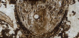
Half-moon shaped holes (black arrows) and circular holes (white arrows) in 780–740 million-year-old fossils of shell-forming amoebae from the Chuar Group of the Grand Canyon, Arizona. Holes are approximately 15 to 35 micrometers in size: shells are 75 to 150 micrometers in length. Credit: Susannah Porter

Vampires are real, and they’ve been around for millions of years. At least, the amoebae variety has. So suggests new research from UC Santa Barbara paleobiologist Susannah Porter.

Using a scanning electron microscope to examine minute fossils, Porter found perfectly circular drill holes that may have been formed by an ancient relation of Vampyrellidae amoebae. These single-celled creatures perforate the walls of their prey and reach inside to consume its cell contents. Porter’s findings appear in the Proceedings of the Royal Society B.

“To my knowledge these holes are the earliest direct evidence of predation on eukaryotes,” said Porter, an associate professor in UCSB’s Department of Earth Science. Eukaryotes are organisms whose cells contain a nucleus and other organelles such as mitochondria.

“We have a great record of predation on animals going back 550 million years,” she continued, “starting with the very first mineralized shells, which show evidence of drillholes. We had nothing like that for early life — for the time before animals appear. These holes potentially provide a way of looking at predator-prey interactions in very deep time in ancient microbial ecosystems.”

Porter examined fossils from the Chuar Group in the Grand Canyon — once an ancient seabed — that are between 782 and 742 million years old. The holes are about one micrometer (one thousandth of a millimeter) in diameter and occur in seven of the species she identified. The holes are not common in any single one species; in fact, they appear in not more than 10 percent of the specimens.

“I also found evidence of specificity in hole sizes, so different species show different characteristic hole sizes, which is consistent with what we know about modern vampire amoebae and their food preferences,” Porter said. “Different species of amoebae make differently sized holes. The Vampyrellid amoebae make a great modern analog, but because vampirelike feeding behavior is known in a number of different unrelated amoebae, it makes it difficult to pin down exactly who the predator was.”

According to Porter, this evidence may help to address the question of whether predation was one of the driving factors in the diversification of eukaryotes that took place about 800 million years ago.

“If that is true, then if we look at older fossil assemblages — say 1 to 1.6 billion years old — the fossilized eukaryote will show no evidence of predation,” Porter said. “I’m interested in finding out when drilling first appears in the fossil record and whether its intensity changes through time.”

Porter also is interested in seeing whether oxygen played a role in predation levels through time. She noted that the microfossils those organisms attacked were probably phytoplankton living in oxygenated surface waters, but like vampyrellid amoebae today, the predators may have lived in the sediments. She suggests that those phytoplankton made tough-walled cysts — resting structures now preserved as fossils — that sank to the bottom where they were attacked by the amoebae.

“We have evidence that the bottom waters in the Chuar Group in that Grand Canyon basin were relatively deep — 200 meters deep at most — and sometimes became anoxic, meaning they lacked oxygen,” Porter explained.

“I’m interested to know whether the predators only were present and making these drill holes when the bottom waters contained oxygen,” Porter added. “That might tie the diversification of eukaryotes and the appearance of predators to evidence for increasing oxygen levels around 800 million years ago.

“We know from the modern vampire amoebae that at least some of them make resting cysts themselves,” Porter said. “A former student of mine joked we should call these coffins. So one of our motivations is to see if we can find these coffins in the fossil assemblage as well. That’s the next project.”


Reference:
Susannah M. Porter. Tiny vampires in ancient seas: evidence for predation via perforation in fossils from the 780–740 million-year-old Chuar Group, Grand Canyon, USA. Proceedings of the Royal Society B: Biological Sciences, 2016; 283 (1831): 20160221 DOI: 10.1098/rspb.2016.0221

Note: The above post is reprinted from materials provided by University of California – Santa Barbara. The original item was written by Julie Cohen.

Orda Cave, Russia

Orda Cave, Russia
Orda Cave, Russia

Orda Cave is a gypsum crystal cave found underneath the western Ural Mountains. The mouth is near the shore of the Kungur River just outside Orda, Perm Krai in Russia. The cave system stretches over 5.1 kilometres (3.2 mi) with around 4.8 kilometres (3.0 mi) over the overall length being under water. This makes it one of the longest underwater caves and the largest underwater gypsum cave in the world. It contains the longest siphon in the former Soviet Union “Russia” (935 meters).

The mineral-rich area surrounding the cave filters the water and makes it very clear. Divers have a visibility of over 50 yards (46 m) making it an ideal location for photographic expeditions. Victor Lyagushkin, a journalist and underwater photographer, led around 150 expeditions into the caves over a six-month period in 2011. The photographs taken by his team were published in the Orda Cave Awareness Project alongside stories from other divers who had visited the cave system. During the dives Lyagushkin used a funnel system to direct the air bubbles to the mouth of the cave and away from the delicate gypsum, fearing that it might easily be damaged. The diving team were also the first people to produce a spherical panorama of an underwater cave.

A local myth tells of the “Lady of the Orda Cave” who is said to live in the caves. In 2013 Natalia Avseenko, a former free diving champion, was featured in a photographic series designed to illustrate the legend. Lyagushkin returned to the site after leading the 2011 dive, taking photographs of Avseenko over a two-day period. The images were taken at depths of up to 17 metres (56 ft) with temperatures that reached down to −23 °C (−9 °F). It is 3 degrees to 20 degrees Celsius below zero just on the surface.

The cave has also been visited during dives by Martyn Farr, Lamar Hires, Pascal Bernabé, and Reggie Ross.

Photo

Map


Note: The above post is reprinted from materials provided by Wikipedia.
Image Courosity:ordacave.ru

Early armored dinosaur from Texas lacked cousin’s club-tail weapon, but had a nose for danger

Early armored dinosaur from-GeologyPage
Pawpawsaurus lived 100 million years ago during the Cretaceous Period. It was first identified from a skull found in north Texas. Credit: Illustration by Karen Carr

Well-known armored dinosaur Ankylosaurus is famous for a hard knobby layer of bone across its back and a football-sized club on its tail for wielding against meat-eating enemies.

It’s prehistoric cousin, Pawpawsaurus campbelli, was not so lucky. Pawpawsaurus was an earlier version of armored dinosaurs but not as well equipped to fight off meat-eaters, according to a new study, said vertebrate paleontologist Louis Jacobs, Southern Methodist University, Dallas. Jacobs is co-author of a new analysis of Pawpawsaurus based on the first CT scans ever taken of the dinosaur’s skull.

A Texas native, Pawpawsaurus lived 100 million years ago during the Cretaceous Period, making its home along the shores of an inland sea that split North America from Texas northward to the Arctic Sea.

Like Ankylosaurus, Pawpawsaurus had armored plate across its back and on its eyelids. But unlike Ankylosaurus, Pawpawsaurus didn’t have the signature club tail that was capable of knocking the knees out from under a large predator.

Ankylosaurus lived about 35 million years after Pawpawsaurus, around 66 million years ago toward the end of the Cretaceous. During the course of its evolution, ankylosaurids developed the club tail, and bone structure in its skull that improved its sense of smell and allowed it to hear a broader range of sounds. “Stable gaze” also emerged, which helped Ankylosaurus balance while wielding its clubbed tail.

“CT imaging has allowed us to delve into the intricacies of the brains of extinct animals, especially dinosaurs, to unlock secrets of their ways of life,” said Jacobs, a professor in the SMU Department of Earth Sciences.

While Pawpawsaurus’s sense of smell was inferior to Ankylosaurus, it was still sharper than some primitive dinosaur predators such as Ceratosaurus, said vertebrate paleontologist Ariana Paulina-Carabajal, first author on the study.

“Pawpawsaurus in particular, and the group it belonged to — Nodosauridae — had no flocculus, a structure of the brain involved with motor skills, no club tail, and a reduced nasal cavity and portion of the inner ear when compared with the other family of ankylosaurs,” said Paulina-Carabajal, researcher for the Biodiversity and Environment Research Institute (CONICET-INIBIOMA), San Carlos de Bariloche, Argentina. “But its sense of smell was very important, as it probably relied on that to look for food, find mates and avoid or flee predators.”

Most dinosaurs don’t have bony ridges in their nasal cavities to guide airflow, but Ankylosaurs are unique in that they do.

“We can observe the complete nasal cavity morphology with the CT scans,” Paulina-Carabajal said. “The CT scans revealed an enlarged nasal cavity compared to dinosaurs other than ankylosaurians. That may have helped Pawpawsaurus bellow out a lower range of vocalizations, improved its sense of smell, and cooled the inflow of air to regulate the temperature of blood flowing into the brain.”

First CT scans shed light on Pawpawsaurus’s sensory tools

Pawpawsaurus is more primitive than the younger derived versions of the dinosaur that evolved later, Jacobs said, although both walked on all fours and held their heads low to the ground.

“So we don’t know if their sense of smell also evolved and improved even more,” Jacobs said. “But we do suspect that scenting the environment was useful for a creature’s survival, and the sense of smell is fairly widely distributed among plant eaters and meat eaters alike.”

The team’s measurements and conclusions are reported in the journal PLOS ONE in the article “Endocranial Morphology of the Primitive Nodosaurid Dinosaur Pawpawsaurus campbelli from the Early Cretaceous of North America.”

The skull was identified in 1996 by Yuong-Nam Lee, Seoul National University, Korea, a co-author on the paper, who was then a doctoral student under Jacobs.

The team’s discoveries emerged from Computed Tomography (CT) scans of the braincase of Pawpawsaurus campbelli’s skull. Pawpawsaurus belongs to one of the least explored clades of dinosaurs when it comes to endocranial anatomy — the spaces in the skull housing the brain.

The Pawpawsaurus skull was discovered 24 years ago by 19-year-old Cameron Campbell in the PawPaw Formation of Tarrant County near Dallas. Conventional analysis of the skull was carried out years ago to identify it as a never-before-seen nodosaurid ankylosaur. However, these are the first CT scans of Pawpawsaurus’s skull because it’s only been in recent years that fossils have been widely explored with X-rays.

In humans, a medical CT will scan the body to “see inside” with X-rays and capture a 3-D picture of the bones, blood vessels and soft tissue. In fossils, a much stronger dose of radiation than can be tolerated by humans is applied to fossils to capture 3-D images of the interior structure.

From the scans, paleontologists can then digitally reconstruct the brain and inner ear using special software.

“Once we have the 3D model, we can describe and measure all its different regions,” Paulina-Carabajal said. “We can then compare that to existing reptile brains and their senses of hearing and smell. Hearing, for example, can be determined from the size of the lagena, the region of the inner ear that perceives sounds.”

The size of the lagena in Pawpawsaurus suggests a sense of hearing similar to that of living crocodiles, she said.

Olfactory acuity, the sense of smell, is calculated from the size ratio of the olfactory bulb of the brain and the cerebral hemisphere.

“In Pawpawsaurus, the olfactory ratio is somewhat lower than it is in Ankyloxaurus, although both have high ratios when compared with most carnivorous dinosarus,” Paulina-Carabajal said. “They are exceeded only by carcharodontosaurids and tyrannosaurids. The olfactory ratios of ankylosaurs in general are more or less similar to those calculated by other authors for the living crocodile.”


Reference:
Ariana Paulina-Carabajal, Yuong-Nam Lee, Louis L. Jacobs. Endocranial Morphology of the Primitive Nodosaurid Dinosaur Pawpawsaurus campbelli from the Early Cretaceous of North America. PLOS ONE, 2016; 11 (3): e0150845 DOI: 10.1371/journal.pone.0150845

Note: The above post is reprinted from materials provided by Southern Methodist University.

A warning system for tsunamis

Japan Tsunami 2011
Japan Tsunami 2011

Seismologists have created a new algorithm that could one day help give coastal cities early warning of incoming tsunamis.

Right now, tsunami warning systems rely on region-specific scenarios based on previous patterns in that area. That’s because scientists use sensors in the ocean, which can detect abnormal movements but can’t make accurate projections of how much water will hit a coast and how hard. But “most likely” isn’t a sure thing. If a real tsunami doesn’t match any of the known scenarios, it could result in significant loss of life.

Scientists at the Australian National University developed the Time Reverse Imaging Method to take real-time data from the ocean sensors and use that information to recreate what the tsunami looked like when it was born. Once scientists have the tsunami source pinpointed, they can use it to make better predictions about what will happen once the waves reach shore. This new method is fast enough to compete with existing algorithms but much more accurate.

“[The Time Reverse Imaging Method] is not based on some guess, it’s based on [real-time] information,” said Jan Dettmer, a seismologist at the university. “[This method] would improve accuracy without sacrificing speed.”

Dettmer and his colleagues will speak about their tsunami-tracking algorithm at the 171st meeting of the Acoustical Society of America, held May 23-27 in Salt Lake City.

The researchers studied plate tectonics in the Japan Trench to help create the algorithm. The earth’s crust is broken up into large plates that float on top of the mantle, which is part of the earth’s core. These plates move and push against each other, ultimately creating deep trenches and high mountains over the course of millennia.

When the movement happens very quickly, it’s an earthquake. Earthquakes can cause landmasses to move several meters, and if it happens underwater it creates a tsunami. Tsunamis kill an average of 8,000 people every year, according to the United Nations Office for Disaster Risk Reduction. That’s why early warning is so important.

“Once the earthquake happens, then we have minutes,” Dettner said. Dettmer’s system takes scientists one step closer to accurately predicting a tsunami’s trajectory. In order to predict its course, you need know the initial sea surface displacement, or, what the wave looked like when it first started.

That’s difficult to do because, while the Japanese government has placed a lot of sensors in the Pacific Ocean, they do not cover the entire seafloor. So Dettmer looked at the information gathered from the March 11, 2011, Tohoku-Oki earthquake and tsunami.

Dettmer took the information from the 2011 event and used it to go backward in time mathematically, calculating what the tsunami looked like when it first started. Once he had the information from the beginning of the tsunami, he added it to the sensor data and projected what the tsunami would look like once it hit land.

By checking his results against what actually happened in 2011, Dettmer was able to hone his algorithm.

The plan is to apply test his method on other recorded earthquakes and fine-tune the technology until it is ready for implementation, which he says could be in less than five years.

“This is a step forward,” Dettmer adds. “This research can be part of the next generation of tsunami warning systems that are based on real time information.”


Note: The above post is reprinted from materials provided by Acoustical Society of America (ASA).

Methane-producing microbes in California rocks

Methane-producing -GeologyPage
The Cedars, shown here, is a small, isolated set of springs flowing out of a large patch of red rock from Earth’s mantle in Sonoma County, California. The Cedars is one of the few easily-accessible sites of serpentinization on land. Scientists report in a new study that they have found evidence of hardy, methane-producing microbes in water that surfaces from deep underground at The Cedars. Credit: Lukas Kohl

Deep in vents on the ocean floor, methane-producing microbes feed off chemical reactions between water and rock. Now evidence of this process has been found on land in a freshwater spring in California.

A team of scientists report in a new study that they have found evidence of hardy, methane-producing microbes in water that surfaces from deep underground at The Cedars, a set of freshwater springs in Sonoma County.

It is the first time scientists have proven that these kinds of methane-producing microbes, which thrive in harsh environments, live anywhere outside of the deep sea. The new finding could offer clues into how early microbes could have lived on Earth billions of years ago and if they might be present on other planets like Mars, according to scientists in the field.

The new study also shows the newly-discovered microbes are likely capable of using carbon dioxide to produce methane — a finding that could have implications for future carbon sequestration projects being proposed in areas similar to The Cedars, said Lukas Kohl, a biogeochemist at Memorial University of Newfoundland in St. John’s, Newfoundland and lead author of the new study published in the Journal of Geophysical Research — Biogeosciences, a journal of the American Geophysical Union.

If the microbes convert carbon dioxide injected into the ground into methane — a potent greenhouse gas — it could offset the benefit gained by carbon sequestration, he said.

“As our technology’s expanding, we’re able to look outside of the box a little to capture some of these groups [of microbes],” said Matt Schrenk, a microbiologist at Michigan State University in East Lansing, Michigan, who was not involved in the study. “As we’re beginning to look into some of these natural environments [deep underground], our view of the microbial world, and of life in general, is really expanding.”

Serpentinization, a process where water reacts with rock to create a green stone called serpentine, is common on the ocean floor. In the process, byproducts of the reaction, including methane, hydrogen, and heat, are released. The Cedars–a small, isolated set of springs flowing out of a large patch of red rock from Earth’s mantle — is one of the few easily-accessible sites of serpentinization on land.

Communities of microbes have been detected at many serpentinization sites across the globe, including in oceanic vents and sites deep underground. These harsh, high-pH environments have few organic molecules for organisms to feed on. These hardy microbes likely use the byproducts of serpentinization as an energy source, according to the study’s authors. Until the new study, however, the only sites known to host microbes that released methane as a waste product were deep underwater, Schrenk said.

Previous analysis of water from The Cedars suggested some of the methane found in the springs could have come from microbes. To confirm the microbes could produce the methane at The Cedars, the study’s authors took water samples from the springs and exposed the samples to different conditions in the laboratory.

In one group of samples they killed any living microbes. In these samples, they did not detect any additional methane being produced.

The samples with live microbes, however, produced significant amounts of methane. In some cases, the live-microbe vials contained 650 percent more methane than vials with dead microbes. The scientists were also able to trace the methane, and determine that it had been produced by microbes, rather than as a product of serpentinization. The new study, combined with previous data, suggests a significant portion of methane in water at The Cedars likely comes from the microbes living there.

The new findings also suggest the microbes can convert carbon dioxide into methane. Some scientists have proposed injecting carbon dioxide from the air into rocks like those at The Cedars. The carbon dioxide interacts with the rock and water to form a solid carbonate that can sequester carbon underground indefinitely and keep it out of the air. But if the microbes convert the injected carbon dioxide to methane and release it into the atmosphere, it would defeat the purpose of sequestration, Schrenk said. “If some of that [sequestered] carbon dioxide is converted to an even more potent greenhouse gas, we’re really in trouble,” he said.

The new study also sheds light on how microbes could have used the energy and chemicals from serpentinization to survive on early Earth when the atmosphere contained less oxygen and fewer organic molecules, said William Brazelton, an astrobiologist at the University of Utah in Salt Lake City who was not involved with the study. Further, the methane they released could have had an impact on the environment and the Earth’s evolution, he added.

The discovery of the methane-producing microbes at The Cedars also gives hope to those searching for life on Mars, Brazelton said. Some surveys of the Martian atmosphere have found methane, which was thought to be a product of serpentinization. This study shows the methane could be a product of both serpentinization and microbes, Brazelton said.


Reference:
Lukas Kohl, Emily Cumming, Alison Cox, Amanda Rietze, Liam Morrissey, Susan Q. Lang, Andreas Richter, Shino Suzuki, Kenneth H. Nealson, Penny L. Morrill. Exploring the metabolic potential of microbial communities in ultra-basic, reducing springs at The Cedars, CA, USA: Experimental evidence of microbial methanogenesis and heterotrophic acetogenesis. Journal of Geophysical Research: Biogeosciences, 2016; 121 (4): 1203 DOI: 10.1002/2015JG003233

Note: The above post is reprinted from materials provided by American Geophysical Union.

Barium leaches directly from fracked rocks

Barium leaches directly from-GeologyPage
Mukul Sharma, a professor of earth sciences at Dartmouth College, and his colleagues are shedding light on the early chemical reactions in the organic sediments that would ultimately become the Marcellus Shale. Credit: Loadmaster (David R. Tribble)

Dartmouth College researchers are shedding light on the early chemical reactions in the organic sediments that would ultimately become the Marcellus Shale, a major source of natural gas and petroleum.

The findings appear in the journal Geochimica et Cosmochimica Acta. The research extends an earlier study by the Dartmouth team.

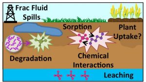
Water injected into shale formations in hydraulic fracturing returns with extraordinarily high total-dissolved-solids and high concentrations of the toxic metal barium. The hazardous wastewater is assumed to be partly due to chemicals introduced into injected freshwater when it mixes with highly saline brine naturally present in the rock. But in their earlier study, the researchers found that chemical reactions between injected freshwater and the fractured shale itself caused barium to leach directly from the fractured rock.

In the new study, the researchers addressed the basic question of when, why and how the Marcellus Shale became enriched in barium in the first place. They studied in detail the chemistry, mineralogy and sulfur isotope composition of a two-inch thick core. It was a special sample as it contains about 5,000 micrograms of barium per gram of rock. Such samples are concentrated only at a few depth intervals in the Marcellus Shale. The sample provided the researchers with insight into how, when and where a barium bearing mineral (barite) altered into iron sulfide (pyrite) during the transformation of organic rich marine sediment into shale in Devonian times.

The researchers discovered barite grains being “bitten” by pyrite as the latter replaced the former through a complex set of reactions that could occur only at a very specific depth interval where both sulfate (barite) and sulfide (pyrite) are present. This interval is called the sulfate-methane transition zone, which has been identified in relatively recent sediments but not in 400 million year old sediments.

“Our new study provides insights into the generalized nature of barium mobilization as barite is dissolved in organic rich sediments and its redistribution in clay minerals,” says senior author Mukul Sharma, a professor of earth sciences.


Reference:
Danielle Niu et al, A relict sulfate–methane transition zone in the mid-Devonian Marcellus Shale, Geochimica et Cosmochimica Acta (2016). DOI: 10.1016/j.gca.2016.03.004

Note: The above post is reprinted from materials provided by Dartmouth College.

Ko Tapu Rock “James Bond Island”

Ko Tapu Rock "James Bond Island"
Tapu Island, Phuket, Thailand Credit: Diego Delso/Wikipedia

Khao Phing Kan (Thai: เขาพิงกัน) or Ko Khao Phing Kan (เกาะเขาพิงกัน) is an island in Thailand, in Phang Nga Bay northeast of Phuket. About 40 metres (130 ft) from the shores of Khao Phing Kan lies a 20-metre (66 ft) tall islet called Ko Tapu or Khao Tapu.

The islands are limestone tower karsts and are a part of Ao Phang Nga National Park. Since 1974, when it was featured in the James Bond movies The Man with the Golden Gun and Tomorrow Never Dies, Khao Phing Kan has been popularly called James Bond Island.

Ko Tapu is a limestone rock about 20 metres (66 ft) tall with the diameter increasing from about 4 metres (13 ft) near the water level to about 8 metres (26 ft) at the top. It lies about 40 metres (130 ft) to the west from the northern part of Khao Phing Kan.

A local legend explains the formation of Ko Tapu as follows. Once upon a time, there lived a fisherman who used to bring home many fish every time he went to the sea. However, one day he could not catch any fish despite many attempts and only picked up a nail with his net. He kept throwing the nail back into the sea and catching it again. Furious, he took his sword and cut the nail in half with all his strength. Upon impact, one half of the nail jumped up and speared into the sea, forming Ko Tapu.

A scientific version of the Ko Tapu formation says that in the Permian period, the area was a barrier reef. Then, upon tectonic movements, it ruptured, and its parts were dispersed over the area and flooded by the rising ocean. Wind, waves, water currents, and tides gradually eroded the islands thus formed, sometimes producing peculiar shapes, such as Ko Tapu. Tide-related erosion is visible at the bottom of the rock.

In The Man with the Golden Gun, Scaramanga describes Ko Tapu as a “mushroom-shaped rock”, which houses two large solar panels which come up on top of Ko Tapu and lock on to the Sun.

Photo

Photo Copyright © Enver Murad

Map


Note: The above post is reprinted from materials provided by Wikipedia.

Mudpot

Mudpot
Fountain Paint Pot “Mudpots” ,Yellowstone

A Mudpot “or Mud Pool”  is a sort of acidic hot spring, or fumarole, with limited water. It usually takes the form of a pool of bubbling mud. The acid and microorganisms decompose surrounding rock into clay and mud.

A mudpot is a natural double boiler! Surface water collects in a shallow, impermeable (usually due to a lining of clay) depression that has no direct connection to an underground water flow. Thermal water beneath the depression causes steam to rise through the ground, heating the collected surface water. Hydrogen sulfide gas is usually present, giving mudpots their characteristic odor of rotten eggs. Some microorganisms use the hydrogen sulfide for energy. The microbes help convert the gas to sulfuric acid, which breaks down rock into clay. The result is a gooey mix through which gases gurgle and bubble.

The mud of a mudpot takes the form of a viscous, often bubbling, slurry. As the boiling mud is often squirted over the brims of the mudpot, a sort of mini-volcano of mud starts to build up, sometimes reaching heights of 3–5 feet. Although mudpots are often called “mud volcanoes”, true mud volcanoes are very different in nature. The mud of a mudpot is generally of white to greyish color, but is sometimes stained with reddish or pink spots from iron compounds. When the slurry is particularly colorful, the feature may be referred to as a paint pot.

Mudpots form in high-temperature geothermal areas where water is in short supply. The little water that is available rises to the surface at a spot where the soil is rich in volcanic ash, clay and other fine particulates. The thickness of the mud usually changes along with seasonal changes in the water table.

Mudpot Colors

Minerals tint the mudpots with such a large palette of colors that the mudpots are sometimes called “paint pots.” Iron oxides cause the pinks, beiges, and grays of the Fountain Paint Pots

Sites

The geothermal areas of Yellowstone National Park contain several notable examples of both mudpots and paint pots, as do some areas of Iceland and New Zealand. Several locations in and around the Salton Sea in California are also home to active mudpots.

Video


Reference:
Wikipedia: Mudpot
Yellowstone National Park: Mudpots

A history of snowfall on Greenland, hidden in ancient leaf waxes

A history of snowfall on -GeologyPage
The sediment core used in the new study led by UB researcher Elizabeth Thomas. The column, from a lake bottom in Western Greenland, contains aquatic leaf waxes that reveal information about the history of precipitation at the site. Credit: Jason Briner

The history of Greenland’s snowfall is chronicled in an unlikely place: the remains of aquatic plants that died long ago, collecting at the bottom of lakes in horizontal layers that document the passing years.

Using this ancient record, scientists are attempting to reconstruct how Arctic precipitation fluctuated over the past several millennia, potentially influencing the size of the Greenland Ice Sheet as the Earth warmed and cooled.

An early study in this field finds that snowfall at one key location in western Greenland may have intensified from 6,000 to 4,000 years ago, a period when the planet’s Northern Hemisphere was warmer than it is today.

While more research needs to be done to draw conclusions about ancient precipitation patterns across Greenland, the new results are consistent with the hypothesis that global warming could drive increasing Arctic snowfall — a trend that would slow the shrinkage of the Greenland Ice Sheet and, ultimately, affect the pace at which sea levels rise.

“As the Arctic gets warmer, there is a vigorous scientific debate about how stable the Greenland Ice Sheet will be. How quickly will it lose mass?” says lead researcher Elizabeth Thomas, PhD, an assistant professor of geology in the University at Buffalo College of Arts and Sciences who completed much of the study as a postdoctoral fellow at the University of Massachusetts Amherst.

“Climate models and observations suggest that as temperatures rise, snowfall over Greenland could increase as sea ice melts and larger areas of the ocean are exposed for evaporation. This would slow the decline of the ice sheet, because snow would add to its mass,” Thomas says. “Our findings are consistent with this hypothesis. We see evidence that the ratio of snow to rain was unusually high from 6,000 to 4,000 years ago, which is what you would expect to see if sea ice loss causes snowfall to increase in the region.”

The research was published on May 23 in Geophysical Research Letters, a journal of the American Geophysical Union.

Aquatic plant leaf waxes as a record of snowfall

Thomas’ research looks to understand how precipitation changed in the past, with an eye toward better predicting how modern warming will affect the Earth.

“We are using the past to see what might happen in the future,” she says.

Aquatic leaf waxes are a relatively new tool for completing this work. They reveal information about the seasonality of precipitation — how amounts of ancient summer rain compared to amounts of ancient winter snow.

To understand how aquatic leaf waxes function as a historical record, you need to know a little about aquatic plants. In the Arctic, these organisms survive on lake water, and use hydrogen atoms from this water to produce wax coatings on leaves.

These hydrogen atoms are the key to studying precipitation: In years when the ratio of summer rain to winter snow in a region is high, lake water and aquatic leaf waxes end up containing high levels of a rare form of hydrogen called deuterium, which is heavier than “normal” hydrogen. (This is because summer rain holds more deuterium than winter snowfall.)

In contrast, in years when snow is relatively abundant, aquatic plants start producing waxes with less deuterium.

This is what Thomas and her colleagues saw when they extracted a long, cylindrical sediment sample from a lake bottom in western Greenland. The mud contains ancient leaf waxes, with the oldest at the base of the column and the youngest at the top.

By dating and analyzing thin slices of the sample, the team determined that aquatic leaf waxes had low levels of deuterium from 6,000 to 4,000 years ago.

This is exactly what researchers would expect to see if the warm temperatures of that time had fueled sea ice loss, leading to increased Arctic snowfall and a decline in deuterium in lakes, Thomas said. She acknowledged that it’s possible that a drop in summer rainfall accounted for the changes in deuterium, but says a rise in winter snowfall is the more likely explanation, as scientists have found independent evidence that the region was wetter 6,000 to 4,000 years ago.


Reference:
Elizabeth K. Thomas, Jason P. Briner, John J. Ryan-Henry, Yongsong Huang. A major increase in winter snowfall during the middle Holocene on western Greenland caused by reduced sea ice in Baffin Bay and the Labrador Sea. Geophysical Research Letters, 2016; DOI: 10.1002/2016GL068513

Note: The above post is reprinted from materials provided by University at Buffalo.

Related Articles