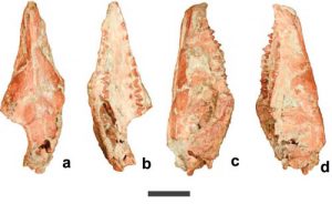
Fig.1 Skull of the zhangheotheriid Anebodon luoi in dorsal (a), ventral (b), right lateral (c) and left lateral (d) views, scale bar 1 cm. Credit: BI Shundong
Mesozoic mammals with molariform teeth bearing a simple, triangular arrangement of principal cusps were traditionally assigned to the Order Symmetrodonta. Phylogenetic analyses imply that this grouping is artificial, with the symmetrodont molar pattern representing a structural grade that evolved multiple times.
In fact, weakly-triangulated molariforms, as represented by tinodontids, are present near the base of Mammalia in recent analyses, suggesting that this pattern was shared by the ancestors of dentally specialised but structurally disparate groups such as eutriconodontans, multituberculates, dryolestoids, and therians. Therefore, discoveries of well-preserved symmetrodont specimens have the potential to illuminate the morphological transitions that gave rise to therians.
Symmetrodonts with acutely-triangulated molar cusps (or “acute-angled symmetrodonts”) form a monophyletic group in recent analyses, positioned at the base of the Trechnotheria, a clade which also contains dryolestoids and therians. These symmetrodonts are known principally from the Early Cretaceous and became extinct prior to the Campanian. They segregate into two lineages: the Spalacotheriidae, a diverse group which contain some dentally specialised taxa bearing a high number of mesiodistally compressed molars, and the Zhangheotheriidae, a group restricted to Asia and bearing a more primitive dentition.
In a study published online May 24 in the journal Scientific Reports, Dr. BI Shundong of the Institute of Vertebrate Paleontology and Paleoanthropology (IVPP) of the Chinese Academy of Sciencesreport, and his collaborators reported the discovery of Anebodon luoi, a new genus and species of zhangheotheriid symmetrodont mammal from the Lujiatun site of the Lower Cretaceous Yixian Formation in Liaoning Province of China. This finding provides new information for discussion of trechnotherian character evolution, and ultimately sheds additional light on the evolution of therians.
The new specimen is an associated partial skull and dentaries with a nearly complete dentition, and it is referred to the Zhangheotheriidae based primarily on features of the dentition. It lacks the high molar count typical of derived symmetrodonts, and differs from the well-represented zhangheotheriids Zhangheotherium and Maotherium in having a postcanine dental formula that resembles more primitive tinodontid symmetrodonts on the one hand, and sister taxa to therians such as Peramus on the other.
Upper and lower distal premolars of Anebodon luoi are strongly molariform. Researchers captured undergoing tooth replacement, clarifying positional homology among related taxa.
“We interpret our specimen to have an upper postcanine formula of P5/M3, which is generally thought to be the primitive count for therians. Additionally, the penultimate upper premolar (P4) in Anebodon is the tallest tooth in the postcanine series, a feature also characteristic of therians. Some degree of molarization of the posterior premolars also occurs in various spalacotheriids, but evidence of replacement of strongly molariform teeth is currently lacking in this derived group. Retention of molariform premolars in the adult dentition is also a characteristic of the endemic South American meridiolestidan dryolestoids; the distribution of this feature suggests that it is basal to the Trechnotheria and possibly represents the primitive condition for the therian line,” said BI Shundong.
“We also describe the rostrum and, for the first time in a symmetrodont, much of the orbital mosaic. Importantly, our new taxon occupies a basal position within the Zhangheotheriidae and permits discussion of trechnotherian character evolution, ultimately shedding additional light on the evolution of therians,” said study co-author Brian Davis, a professor from the Department of Anatomical Sciences and Neurobiology at the University of Louisville.
Reference:
Shundong Bi et al. A new symmetrodont mammal (Trechnotheria: Zhangheotheriidae) from the Early Cretaceous of China and trechnotherian character evolution, Scientific Reports (2016). DOI: 10.1038/srep26668
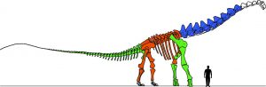
Figure 2 caption: This is a drawing of the skeleton of Alamosaurus sanjuanensis compared to a 180cm (5ft 11″) human. Based on reconstructed skeleton exhibited at the Perot Museum of Nature and Science, in Dallas, Texas. Colored bones indicate the institutional collection upon which that part of the skeleton was based. Blue = Perot Museum, Green = Smithsonian Institution, Orange = Vertebrate Paleontology Laboratory of the University of Texas at Austin. Credit: Ronald S. Tykoski, Ph.D.
The discovery nearly two decades ago of nine beautifully articulated vertebrae at Big Bend National Park is shedding new light on a 66 million-year-old sauropod native to Texas and the North American southwest called Alamosaurus sanjuanensis.
Paleontologists from the Perot Museum of Nature and Science in Dallas have co-authored a scientific paper entitled “An articulated cervical series of Alamosaurus sanjuanensis Gilmore, 1922 (Dinosauria, Sauropoda) from Texas: new perspective on the relationships of North America’s last giant sauropod.” Their findings are now available online as an open access article at the Journal of Systematic Palaeontology website and will appear in its forthcoming January/February 2017 print edition. The lead author is Ronald S. Tykoski, Ph.D., the Perot Museum’s Director of Paleontology Lab, and the co-author is Anthony R. Fiorillo, Ph.D., the Perot Museum’s Chief Curator and Vice President of Research and Collections.
“Giant sauropods like Alamosaurus have amazed people since the 1800s. Their sheer size boggles the mind, and they have forced scientists to re-think the physical limits of land-living animals,” said Tykoski. “The fossils described in our paper reveal new details about the last sauropods in North America, which helps us better understand who Alamosaurus was related to and how this species made it to southern North America by 67 to 66 million years ago – just in time to go extinct at the end of the Cretaceous!”
The name Alamosaurus came from the Ojo Alamo trading post and geological formation in New Mexico from which the first bones of the species were found (not after the historic battle in San Antonio, Texas in 1836). The name of the trading post stemmed from the Spanish word for a huge cottonwood tree growing at the trading post. Alamosaurus was a titanosaur sauropod, one of the groups of long-necked and long-tailed dinosaurs that included the largest animals to walk the Earth.
The discovery of the massive bones came in 1997 when a joint field crew from the University of Texas at Dallas (UT-D) and the Perot Museum (known at that time as the Dallas Museum of Natural History) was working in the northeast section of Big Bend National Park. The scientists and volunteers were excavating a site that produced parts of several immature sauropods when Dana Biasatti, then a student at UT-D, “stretched her legs” and came upon the remarkable remains of an adult titanosaur a few hundred yards away. The team was stunned. The nine cervical (neck) vertebrae were the first articulated series of adult Alamosaurus neck bones ever found. The fossils of Alamosaurus from Big Bend National Park currently represent the biggest dinosaurs discovered in Texas.
“It was one of those days one doesn’t ever forget. The part of the animal that was exposed at the surface was the hip region. Probing around the site resulted in the discovery of this incredible neck,” said Fiorillo. “One of the intriguing aspects of this project is that for us to better understand this dinosaur in our home state, we had to also rely, in part, on the results of the scientific work the Perot Museum has been doing in Arctic Alaska over the same window of time.”
Four years later – after gaining the full cooperation and necessary permits from the National Park Service and lining up Bell Helicopter to help transport the fossils (at no cost) from the remote wilderness site – the Perot Museum and UT-D team returned to the West Texas site for their top-secret mission to recover the adult sauropod bones.
For eight mostly hot and dusty days in early May 2001, they gingerly dug out the vertebrae, then hauled almost 3,000 lbs. of plaster, wood, burlap and water on their backs to create the jackets protecting the huge bones. On the final day, the field team, along with excited members of the National Park Service and other spectators, nervously watched as the helicopter gently lifted the plaster jackets – some weighing a half of a ton or more – from the excavation site. Dangling from the chopper about 50 feet above ground, the precious cargo was slowly transported to a flatbed truck about a mile away. Once packed and safely secured, the jackets began their 550-mile journey to the Perot Museum paleo lab at Fair Park in Dallas where they’d undergo years of fossil preparation work.
“This remarkable discovery illustrates the importance of America’s public lands as places where scientists have access to perform research that benefits everyone,” said Cindy Ott-Jones, Superintendent of Big Bend National Park. “While Big Bend National Park is a place that many people enjoy for its scenery and recreational opportunities, visitors should know that a tremendous amount of scientific research is also performed in the park.”
Today, visitors can view the actual fossilized neck bones from Big Bend at the Perot Museum of Nature and Science, which opened in December 2012 near downtown Dallas. The enormous bones served as the inspiration for the centerpiece for the Museum’s T. Boone Pickens Life Then and Now Hall, a fully assembled skeleton of the Alamosaurus standing 25 feet tall and stretching more than the length of two school buses, dwarfing a Tyrannosaurus rex standing next to it. Laser digitization and 3D printing were used to create lightweight replicas of the Perot Museum’s dinosaur’s neck, along with portions of the body obtained from another skeleton at the University of Texas at Austin, and tail and leg bones in the collections of the Smithsonian Institution in Washington, D.C. A crowd favorite, the breathtaking cast was fabricated and mounted by Research Casting International of Ontario, and it remains the only rendition of a complete Alamosaurus skeleton on exhibit anywhere in the world.
Once the decision was made in 2009 to feature the Alamosaurus at the new facility, Tykoski recalls it was a three-year Herculean effort to get the vertebrae ready for the Museum’s debut. Extra staff and more than two dozen volunteers worked thousands of hours meticulously whittling away 66 million years of sediment that entombed the dinosaur bones.
Both of the Perot Museum’s paleontologists credit the success of the 19-year initiative to the numerous partners who collaborated and cooperated from start to finish.
“The paper is just the culmination of almost two decades of hard work and incredible collaboration and partnerships between so many agencies and institutions,” said Tykoski. “From people at UT-D, Big Bend National Park, Bell Helicopter, the Smithsonian Institution, the Vertebrate Paleontology Lab at UT-Austin, the dedicated staff and volunteers at the Perot Museum, and other paleontologists who offered advice and insight about these animals, so many people contributed to getting the science done and the information out there for the world to see.”
“This was such an incredible find, and we were able to work with so many people to help us reach a successful conclusion. I guess, at some level, everyone reverted back to their childhood awe of giant dinosaurs,” added Fiorillo.
Reference:
Ronald S. Tykoski & Anthony R. Fiorillo, An articulated cervical series of Alamosaurus sanjuanensis Gilmore, 1922 (Dinosauria, Sauropoda) from Texas: new perspective on the relationships of North America’s last giant sauropod. DOI:10.1080/14772019.2016.1183150
Diamond is a metastable allotrope of carbon, where the carbon atoms are arranged in a variation of the face-centered cubic crystal structure called a diamond lattice. Diamond is less stable than graphite, but the conversion rate from diamond to graphite is negligible at standard conditions. Diamond is renowned as a material with superlative physical qualities, most of which originate from the strong covalent bonding between its atoms. In particular, diamond has the highest hardness and thermal conductivity of any bulk material. Those properties determine the major industrial application of diamond in cutting and polishing tools and the scientific applications in diamond knives and diamond anvil cells.
Because of its extremely rigid lattice, it can be contaminated by very few types of impurities, such as boron and nitrogen. Small amounts of defects or impurities (about one per million of lattice atoms) color diamond blue (boron), yellow (nitrogen), brown (lattice defects), green (radiation exposure), purple, pink, orange or red. Diamond also has relatively high optical dispersion (ability to disperse light of different colors).
Most natural diamonds are formed at high temperature and pressure at depths of 140 to 190 kilometers (87 to 118 mi) in the Earth’s mantle. Carbon-containing minerals provide the carbon source, and the growth occurs over periods from 1 billion to 3.3 billion years (25% to 75% of the age of the Earth). Diamonds are brought close to the Earth’s surface through deep volcanic eruptions by a magma, which cools into igneous rocks known as kimberlites and lamproites. Diamonds can also be produced synthetically in a HPHT method which approximately simulates the conditions in the Earth’s mantle. An alternative, and completely different growth technique is chemical vapor deposition (CVD). Several non-diamond materials, which include cubic zirconia and silicon carbide and are often called diamond simulants, resemble diamond in appearance and many properties. Special gemological techniques have been developed to distinguish natural diamonds, synthetic diamonds, and diamond simulants. The word is from the ancient Greek ἀδάμας – adámas “unbreakable”.
Diamond Formation
The formation of natural diamond requires very specific conditions—exposure of carbon-bearing materials to high pressure, ranging approximately between 45 and 60 kilobars (4.5 and 6 GPa), but at a comparatively low temperature range between approximately 900 and 1,300 °C (1,650 and 2,370 °F). These conditions are met in two places on Earth; in the lithospheric mantle below relatively stable continental plates, and at the site of a meteorite strike.
1-Earth’s Mantle “Cratons”
The conditions for diamond formation to happen in the lithospheric mantle occur at considerable depth corresponding to the requirements of temperature and pressure. These depths are estimated between 140 and 190 kilometers (87 and 118 mi) though occasionally diamonds have crystallized at depths about 300 km (190 mi). The rate at which temperature changes with increasing depth into the Earth varies greatly in different parts of the Earth. In particular, under oceanic plates the temperature rises more quickly with depth, beyond the range required for diamond formation at the depth required. The correct combination of temperature and pressure is only found in the thick, ancient, and stable parts of continental plates where regions of lithosphere known as cratons exist. Long residence in the cratonic lithosphere allows diamond crystals to grow larger.
Through studies of carbon isotope ratios (similar to the methodology used in carbon dating, except with the stable isotopes C-12 and C-13), it has been shown that the carbon found in diamonds comes from both inorganic and organic sources. Some diamonds, known as harzburgitic, are formed from inorganic carbon originally found deep in the Earth’s mantle. In contrast, eclogitic diamonds contain organic carbon from organic detritus that has been pushed down from the surface of the Earth’s crust through subduction (see plate tectonics) before transforming into diamond. These two different source of carbon have measurably different 13C:12C ratios. Diamonds that have come to the Earth’s surface are generally quite old, ranging from under 1 billion to 3.3 billion years old. This is 22% to 73% of the age of the Earth.
Diamonds occur most often as euhedral or rounded octahedra and twinned octahedra known as macles. As diamond’s crystal structure has a cubic arrangement of the atoms, they have many facets that belong to a cube, octahedron, rhombicosidodecahedron, tetrakis hexahedron or disdyakis dodecahedron. The crystals can have rounded off and unexpressive edges and can be elongated. Sometimes they are found grown together or form double “twinned” crystals at the surfaces of the octahedron. These different shapes and habits of some diamonds result from differing external circumstances. Diamonds (especially those with rounded crystal faces) are commonly found coated in nyf, an opaque gum-like skin.
2-Subduction Zones
Many important natural resources are derived from subduction processes. Oil and natural gas reserves, fresh, highly fertile soils, and gold, silver, uranium, and diamonds are all formed at convergent plate boundaries.
The presence of microdiamonds within rocks of continental affinity suggests that these rocks, despite their intrinsic buoyancy, were subducted into the upper mantle to a minimum depth of 150 km and subsequently exhumed to the earth’s surface. This discovery spurred unprecedented multidisciplinary investigations of continental collisions, mountain building, mantle enrichment in H2O, and rare earth and lithophile elements, including 40K, which has strong influence on the earth’s thermal evolution. The discovery of these microdiamonds, as well as coesite, triggered a major revision in understanding of deep subduction processes, leading to the realization that continental materials can be recycled into the earth’s interior, and establishing a new scientific discipline, ultra-high-pressure metamorphism.
3-Impact Sites “Asteroids”
Throughout the history of the earth, it has been frequently hit by huge asteroids. When these hypervelocity objects strike the earth with great force, it produces temperature that is hotter than the surface of the Sun and energy burst that is equal to millions of nuclear weapons.
These high pressure and temperature conditions that are produced in such an impact are very suitable for the formation of the diamonds. The tiny diamonds that are found around various asteroid impact sites support this theory of diamond formation.
Although such diamonds are rare to find and are not adequate for commercial use, but they still are the source of diamond material. The examples of these types of diamonds are the sub-millimeter, tiny diamonds that have been discovered in Arizona at Meteor Crater. Another diamonds are of 13 millimeters polycrystalline industrial diamonds that were found in Siberia, Russia at Popigai Crater.
4-Space
Not all diamonds found on Earth originated on Earth. Primitive interstellar meteorites were found to contain carbon possibly in the form of diamond. A type of diamond called carbonado that is found in South America and Africa may have been deposited there via an asteroid impact (not formed from the impact) about 3 billion years ago. These diamonds may have formed in the intrastellar environment, but as of 2008, there was no scientific consensus on how carbonado diamonds originated.
Diamonds can also form under other naturally occurring high-pressure conditions. Very small diamonds of micrometer and nanometer sizes, known as microdiamonds or nanodiamonds respectively, have been found in meteorite impact craters. Such impact events create shock zones of high pressure and temperature suitable for diamond formation. Impact-type microdiamonds can be used as an indicator of ancient impact craters. Popigai crater in Russia may have the world’s largest diamond deposit, estimated at trillions of carats, and formed by an asteroid impact.
Scientific evidence indicates that white dwarf stars have a core of crystallized carbon and oxygen nuclei. The largest of these found in the universe so far, BPM 37093, is located 50 light-years (4.7×10¹⁴ km) away in the constellation Centaurus. A news release from the Harvard-Smithsonian Center for Astrophysics described the 2,500-mile (4,000 km)-wide stellar core as a diamond.
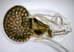
The chordate O. dioica, despite losing lots of genes, maintains a typical body plan with organs and structures (heart, brain, thyroids, etc.) which can be considered to be homologues to the vertebrates. Credit: Image courtesy of Universidad de Barcelona
“Loss is nothing else but change and change is nature’s delight” says the quote by the philosopher and emperor Marcus Aurelius, which opens the scientific article that analyses the gene loss phenomenon and its impact on the evolution of living beings.
The study was published in the magazine Nature Review Genetics and signed by professors Ricard Albalat and Cristian Cañestro, from the Department of Genetics, Microbiology and Statistics and the Biodiversity Research Institute (IRBio) of the University of Barcelona. This article has just been selected as one of the recommended works with special significance in genetics and genomics by the Faculty of 1000 Prime, an international ranking that identifies and re-evaluates the best articles on biology and medicine with the support from a scientific community of more than 10,000 academics worldwide.
Thinking of gene loss as an evolution force is a counterintuitive idea, for it is easier to think that only when we gain something -genes in this case- can we evolve. However the new work by these authors, who are members of the Research Group on Evolution and Development (EVO-DEVO) of the UB, paints the vision of gene loss as a great potential process of genetic change and evolutionary adaption.
Losing genes is also an evolution engine
A gene is lost when the genome is physically removed (by illegitimate recombination, transposition, etc.) or when it is still in the genome but with no use due to a mutation (particular changes, insertions, deficiencies, etc.). “The genome sequencing of very different organisms has shown that gene loss has been a usual phenomenon during evolution in all life cycles. In some cases, it has been proven that this loss might mean an adaptive response towards stressful situations when facing sudden environmental changes” says Professor Cristian Cañestro.
“In other cases, there are genetic losses -says Cañestro- which even though they are neutral per se, have contributed to the genetic and reproductive isolation among lineages, and thus, to speciation, or have rather participated in the sexual differentiation in contributing to the creation of a new Y chromosome. The fact that genetic loss patterns are not stochastic but rather biased in the lost genes (depending on the kind of function of the gen or its situation in the genome in different organism groups) stresses the importance of the genetic loss in the evolution of the species.
Losing to win: an evolutionary paradox
Traditionally, it was believed that insects tended to lose genes. However, the genome sequencing of a beetle (Tribolium castaneum), which proves to have few gen losses, has made it worth reconsidering. In the chordates phylum, which includes vertebrates, there are also some differences among the species, with particular cases such as the planktonic organism Oikopleura dioica -very prone to gen loss.
According to Professor Ricard Albalat, “it has been shown that the possibility of losing genes is linked to the lifestyle of the species. Parasites, for instance, show a greater tendency of gene loss because since they re-use their host’s resources, lots of their genes become dispensable and end up disappearing. Species with lots of redundant genes such as the vertebrates and lots of plant species and yeasts which have doubled their genome, have also suffered from gene loss over the course of evolution.
“Interestingly -says Albalat- the massive gene losses are not always linked to radical morphological changes in the affected organism’s body plan. The chordate Oikopleura dioica, for example, despite losing lots of genes -some are essential to the embryo development and design of the phylum body plan- maintains a typical body plan with organs and structures (heart, brain, thyroids, etc.) which can be considered to be homologues to the vertebrates’. However, this contradiction, which we have defined as “inverse paradox” of EvoDevo, is still very difficult to explain.”
Lost genes in the human evolutionary history
Gene loss can become a positive condition. This has been proved with laboratory experiments (in yeast or bacteria) and population studies on humans. Some of the best studied cases on humans are coding gene losses with cell receptors (CCR5 and DUFFY), which make individuals more resistant to HIV infection and to plasmodium caused by malaria. In nature, there are gene losses from which some organisms benefited: losses which made colour changes in flowers which attract new pollinators, losses which made warmness-resistant insects to be able to colonize new habitats, etc.
Some studies also suggest that gene loss has been decisive in the origins of the human species. Chimpanzees and humans share more than the 98% of their genome -something which has always been of great interest- and in this context it is tempting to speculate that perhaps it would be necessary to look for the differences not in the shared genes but in the lost ones- the ones which have been lost in a different way through the human and primate evolution. “For example, it is believed that gene loss reduced the jaw muscular structure, which allowed the human brain to grow its size, or that gene losses were important in the improvement of our defence system against illnesses,” says Cristian Cañestro.
How many gens can a living being lose?
A gene can be lost only if it is dispensable and, therefore, its loss doesn’t involve a disadvantage for the individuals. What makes a gene to be dispensable? A gene becomes dispensable when the organism can do its function in an alternative way (functional redundancy) or when the gene is no longer needed because the organism lost its structure or the physiologic requirement in which the gene participated (regressive evolution). For this reason, some changes in the species’ lifestyle can turn some genes dispensable, as seen in the gene loss related to pigmentation and vision of the species who adopted cave-dweller ways of life.
Discovering how many genes an organism can lose and how, is something essential to understand how many human genes are dispensable and why certain mutations are irrelevant while others are dramatic for our health. Actually, the recent genome sequencing in individuals from several communities around the world has shown that any healthy person has an average amount of 20 genes not working and it does not seem to provoke any unfavourable consequence.
When genes are dispensable: less is more
According to Ricard Albalat, “probably, the presences of redundant genes or environmental conditions in which we live make us to have less unnecessary genes. Researching on the differences of gene losses among different human communities has allowed, for instance, discovering that lipoprotein A gene loss grants resistance to coronary illnesses among the Finnish population who have fat-rich diets. This experimental approach which relates genes to diseases, called “genotype first,” opens the door to the discovery of genes which, when disappearing, give an advantage towards some environmental tensions (diets, climate, toxics, pathogens, etc.) and therefore it could help identifying new genes with therapeutic interests.”
Oikopleura dioica: a new model organism in UB’s research
Promoting basic research with model organisms (bacteria, mice, yeast, plants, zebrafish, Drosophila or C. elegans) has been a key fact to promote the progress in the field of biomedicine and health. For the scientists, one 21th Century challenge is to develop animal models alternative to the classic ones which can enable applying massive sequencing technologies or also genetic systematic modifications to open new perspectives in the field of basic research. Only by creating basic knowledge is it possible to improve with society’s wellbeing.
Nowadays the Evo-Devo-Genomics team of the UB is one of the few research groups around the world which studies the Oikopleura dioica from an evolutionary developmental biology perspective (Evo-Devo). This is also the only team in Spain which has launched a scientific infrastructure -there are two more in Bergen (Norway) and Osaka (Japan)- considered as an international projecting referent with the ability of developing and studying this new model organism.
The Oikopleura dioica is a small animal, with a short life cycle, very prolific and easy to keep in the laboratory. These conditions make it an excellent model animal. Its genome, sequenced, is extraordinarily compact -three times smaller than the one of the Drosophila fly- and has lost a lot of genes. Currently, the UB experts use O. dioica as evolution mutant which has lots important genes for the embryo development. The research group works in two research lines. On the one hand, they use O. dioica to research on the toxic compound effect in marine animal development and reproduction, as well as its impact on the ocean trophic chains. On the other hand, they use O. dioica to study how genetic losses have affected the cardio development mechanisms.
“We hope these studies enable us to identify the essential ‘minimum gene set’ to produce a heart, and would help us understand better the genetic basics of certain cardiomyopathies and discover new genes to improve the diagnosis” say Ricard Albalat and Cristian Cañestro.
Reference:
Linda Koch. Complex disease: A global view of regulatory networks. Nature Reviews Genetics, 2016; 17 (5): 252 DOI: 10.1038/nrg.2016.36
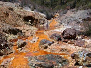
Acid mine drainage causes severe environmental problems in the Rio Tinto, Spain. Credit: Carol Stoker, NASA
The collective estimated amount of carbon dioxide being released into the atmosphere from 140 coal mines across Pennsylvania is the equivalent to that of a small power plant, a new West Virginia University study finds.
Dorothy Vesper, associate professor in the Department of Geology and Geography at West Virginia University, and her research team, are using a meter designed for measuring carbon dioxide in beverages to more accurately measure the gas in mine drainage water. Using measurements from several sites and estimated values from United States Geological Survey data for 140 Pennsylvania mines, they’ve calculated the amount of carbon dioxide released from abandoned coal mines.
“Many people calculate carbon dioxide from alkalinity, or the capability of water to neutralize acid, so the pH has to be above five, but if you have a lot of carbon dioxide dissolved in the water, it forces the pH to fall below five and people just dismiss it and ignore it,” Vesper said.
“So, there is a bias in the way people typically estimate the carbon dioxide concentrations in water, and they’ve ignored this whole set of mine waters, but we’re able to actually quantify them nicely.
“A lot of those very low pH waters have plenty of carbon dioxide in them.”
Mine drainage, a byproduct of areas active in ore or coal mining, has long been associated with contaminated drinking water, disrupted growth and reproduction of certain types of plants and animals, and infrastructure corrosion. Sulfate-rich mine water can dissolve the surrounding limestone, allowing carbon dioxide gas to be present in the water. When mine waters discharge at the land surface, some of the carbon dioxide releases into the atmosphere.
“The gas is really high in mine waters and people who work with mine waters know that, but no one has quantified it in detail,” said Vesper. “No one has really developed an accurate way to measure the carbon dioxide coming out, partially because it is very difficult.”
Vesper and her team measured carbon dioxide levels in the water at two mine portals and compared those data to estimated gas levels for a limited set of inactive mines across Pennsylvania. These findings – that the total amount of carbon dioxide released from those mines was found to be equivalent to that of a small power plant — have opened the door to larger studies determining the impact carbon dioxide evasion from mine drainage has on the environment.
“I think right now, the next thing I want to do is get a better handle on this and get a much more quantitative assessment at more sites,” Vesper said. “I think we’re also going to work with some of the geographic information system researchers at the Davis College of Agriculture, Natural Resources and Design to see if we can do a larger scale estimate for Pennsylvania or West Virginia.”
This work was initiated with Harry Edenborn, Ph.D., as part of the National Energy Technology Laboratory’s Regional University Alliance (NETL-RUA), a collaborative initiative of the organization. Ongoing work is funded by the NSF-EPSCOR funded Appalachian Freshwater Initiative at WVU.
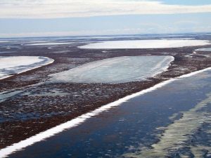
Shallow lakes on the Coastal Plain of Alaska. New research finds permafrost below shallow lakes such as these is thawing as a result of changing winter climate. Credit: Christopher Arp, University of Alaska Fairbanks.
New research shows permafrost below shallow Arctic lakes is thawing as a result of changing winter climate.
Warmer winters combined with an increase in snowfall during the last 30 years have limited the growth of seasonal lake ice. In response, lakebed temperatures of Arctic lakes less than 1 meter (3 feet) deep have warmed by 2.4 degrees Celsius (4.3 degrees Fahrenheit) during the past three decades, and during five of the last seven years, the mean annual lakebed temperature has been above freezing.
These rates of warming are similar to those observed in terrestrial permafrost, yet those soils are still well below freezing and thaw is not expected for at least another 70 years. However, a regime shift in lake ice is leading to sub-lake permafrost thaw now.
Since permafrost underneath lakes is generally warmer than the surrounding terrestrial permafrost, rising temperatures in the lakebeds make permafrost thaw sooner than beneath surrounding dry land. These lakes may cover 20 to 40 percent of the landscape in vast areas of Arctic lowlands.
“During the 1970s, late winter lake ice thickness measurements commonly exceeded 2 meters (6.5 feet) in northern Alaska. Such thick ice growth helps to limit sub-lake permafrost thaw by freezing the sediments solid each winter. However, during winter field surveys over the last decade, lake ice has typically only grown to 1.5 meters (5 feet) thick, and has been as thin as 1.2 meters (4 feet),” said Christopher Arp, research assistant professor at the University of Alaska Fairbanks (UAF) Water and Environmental Research Center and lead author of the new study accepted for publication in Geophysical Research Letters, a journal of the American Geophysical Union.
These drastic reductions in lake ice, caused by changes in winter climate, are the primary reason that shallow lakebed temperatures are warming and the permafrost below them is thawing.
Interactions and feedbacks among climate, permafrost, and hydrology underscore the complexity of forecasting change in the Arctic. For example, thinner lake ice may help fish overwintering, or it may help the oil industry since they need lake water to build winter ice roads. However, sub-lake permafrost thaw will likely unlock a portion of the permafrost carbon pool and potentially release this carbon in the form of greenhouse gases.
These findings also highlight the importance of conducting winter fieldwork in the Arctic.
“Arctic lakes and ponds are typically ice covered for nine months of the year, but research on them typically occurs during the short Arctic summer. To more fully understand Arctic lake dynamics and to document the changes we have observed requires also doing fieldwork under often harsh conditions during the cold and dark arctic winter,” said Benjamin Jones of the U.S. Geological Survey in Anchorage and co-author of the new study.
“With further thawing of sub-lake permafrost there is a good chance that the ground will subside, increasing the lake depth and accelerating further permafrost thawing. In contrast, the warming on the land may increase the protective vegetation layer and delay thawing of permafrost outside of lakes,” said Vladimir Romanovsky of the UAF Geophysical Institute and co-author of the new study.
With increasingly warmer and snowier winters yielding thinner lake ice, shallow lakes will likely continue to warm, Arp said.
Reference:
Christopher D. Arp, Benjamin M. Jones, Guido Grosse, Allen C. Bondurant, Vladimir E. Romanovsky, Kenneth M. Hinkel, Andrew D. Parsekian. Threshold Sensitivity of Shallow Arctic Lakes and Sub-lake Permafrost to Changing Winter Climate. Geophysical Research Letters, 2016; DOI: 10.1002/2016GL068506
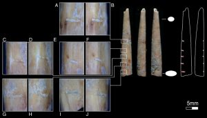
Bone projectile point tip with five horizontal incisions down left side: view of incisions from the dorsal aspect (A, C, E, G, I); view of incisions from the left side (B, D, F, H, J). Magnification: 150x.
Researchers studying bone artefacts discovered in the Kuumbi Cave, Zanzibar, have found evidence to suggest that bone tools were used for hunting, and even as poison arrow tips. The findings, published in the journal Azania: Archaeological Research in Africa, suggest that bone technology was a central element to the Kuumbi Cave’s inhabitants over 13,000 years ago.
Bone technology — such as its use as an arrow tip — was essential to a Stone Age man’s lifestyle and has been shown to have been in use 60,000 years ago. The majority of the evidence to support this has been found in sites in southern Africa, but now the artefacts found in the Kuumbi Cave show that this technology was being adopted in eastern Africa as well.
The researchers investigated seven bone artefacts recovered from the Kuumbi Cave, five bone projectile points, a bone awl, and a notched bone tube. By analysing the artefacts with a camera and microscopes, they were able to compare the manufacture techniques and wear to previous discoveries and to attempts to replicate this technology in the laboratory.
Their findings showed that the bone projectile points are likely to have been used for poison arrows, partly due to the slender and short nature of the arrow heads, and partly supported by a previous discovery of charcoal from the Mkunazi plant, which is known to have poisonous fruit.
The use of poison-tipped arrows by a Stone Age man is thought to have stemmed from a lack of technology and stone-tipped arrows often lack the power to directly kill larger animals, such as zebra or buffalo. Previous work has estimated that poison-tipped arrows may have been used as far back as 24,000 BP (years before present), and the researchers conclude that this technology, better known from southern Africa, may also have been used 13,000 BP in eastern Africa.
Reference:
Michelle C. Langley, Mary E. Prendergast, Ceri Shipton, Eréndira M. Quintana Morales, Alison Crowther, Nicole Boivin. Poison arrows and bone utensils in late Pleistocene eastern Africa: evidence from Kuumbi Cave, Zanzibar. Azania: Archaeological Research in Africa, 2016; 51 (2): 155 DOI: 10.1080/0067270X.2016.1173302
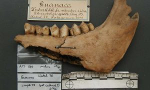
Ancient guanaco jawbone, and tooth sample used to extract DNA, originally excavated from Cueva del Mylodon. Credit: Alan Cooper/Malmo Museum
Giant Ice Age species including elephant-sized sloths and powerful sabre-toothed cats that once roamed the windswept plains of Patagonia, southern South America, were finally felled by a perfect storm of a rapidly warming climate and humans, a new study has shown.
Research led by the Australian Centre for Ancient DNA (ACAD) at the University of Adelaide, published today in Science Advances, has revealed that it was only when the climate warmed, long after humans first arrived in Patagonia, did the megafauna suddenly die off around 12,300 years ago.
The timing and cause of rapid extinctions of the megafauna has remained a mystery for centuries.
“Patagonia turns out to be the Rosetta Stone – it shows that human colonisation didn’t immediately result in extinctions, but only as long as it stayed cold,” says study leader Professor Alan Cooper, ACAD Director. “Instead, more than 1000 years of human occupation passed before a rapid warming event occurred, and then the megafauna were extinct within a hundred years.”
The researchers, including from the University of Colorado Boulder, University of New South Wales and University of Magallanes in Patagonia, studied ancient DNA extracted from radiocarbon-dated bones and teeth found in caves across Patagonia, and Tierra del Fuego, to trace the genetic history of the populations. Species such as the South American horse, giant jaguar and sabre-toothed cat, and the enormous one-tonne short-faced bear (the largest land-based mammalian carnivore) were found widely across Patagonia, but seemed to disappear shortly after humans arrived.
The pattern of rapid human colonisation through the Americas, coinciding with contrasting temperature trends in each continent, allowed the researchers to disentangle the relative impact of human arrival and climate change.
“The America’s are unique in that humans moved through two continents, from Alaska to Patagonia, in just 1500 years,” says Professor Chris Turney, from the University of New South Wales. “As they did so, they passed through distinctly different climate states – warm in the north, and cold in the south. As a result, we can contrast human impacts under the different climatic conditions.”
The only large species to survive were the ancestors of today’s llama and alpaca – the guanaco and vicuna—and even these species almost went extinct.
“The ancient genetic data show that only the late arrival in Patagonia of a population of guanacos from the north saved the species, all other populations became extinct,” says lead author Dr Jessica Metcalf, from the University of Colorado Boulder.
“In 1936 Fell’s cave, a small rock shelter in Patagonia, was the first site in the world to show that humans had hunted Ice Age megafauna. So it seems appropriate that we’re now using the bones from the area to reveal the key role of climate warming, and humans, in the megafaunal extinctions,” says Dr Fabiana Martin, at the University of Magallanes.
Reference:
Synergistic roles of climate warming and human occupation in Patagonian megafaunal extinctions during the Last Deglaciation, Science Advances, DOI: 10.1126/sciadv.1501682
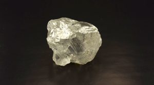
The massive diamond measures 38.64 mm by 27.34 mm by 25.46 mm, and is translucent with a grey hue. Credit: ALROSA
PJSC ALROSA, the world leader in diamond mining, announces the recovery of a 241.21-carat rough diamond from Nyurbinskaya pipe.
It is one of the largest rough diamonds recovered in the Russian Federation and the third largest among those found at Nyurba Mining and Processing Division.
The crystal measures 38.64 mm by 27.34 mm by 25.46 mm, and is translucent with a grey hue. Traces of dissolution–etching channels and caverns–are observed on the surface. The intermediate and peripheral zones contain large cracks, one of which is ferruginized. The crystal contains graphite and sulphide inclusions. The diamond is 4 Black Clivage/Makeable 2 colour.
Nyurbinsky open-pit mine was put into operation in 2001. Identified reserves of the diamond pipe under JORC as of January 1, 2015, amounted to 36.9 million carats.
Nyurba Mining and Processing Division is one of ALROSA’s youngest enterprises. It operates at the Nakyn ore field and develops Nyurbinsky and Botuobinsky open-pit mines, and two same-name alluvial placers. Its share in ALROSA Group’s production totaled 20% in 2015.
Scientists have discovered the cause of a mass extinction of sea-floor marine organisms 800,000 years ago—which also provides insight into how climate change can impact on deep ocean biota.
In a new study published in the journal Nature Communications, scientists from the universities of Nottingham and Durham and the British Geological Survey (BGS), have discovered the cause of a mass extinction within marine organisms called foraminifera. Foraminifera are an important group in relation to biomass in the deep ocean and the cause of their extinction was previously unknown.
Scientists tested various possible causes for the mass extinction and were able to discount others such as ocean cooling. Instead they discovered that the extinction was caused by a global change in plankton at the surface of the ocean.
Important group of organisms
These plankton (coccolithophores) are the food source for seafloor-living foraminifera, and are an important group of organisms at the base of the food web for all life in the ocean (for example, krill, fish, whales). They ‘bloom’ at certain times of the year in such numbers that it is sometimes visible from space.
Dr Sev Kender from The School of Geography at The University of Nottingham, said: “We discovered that the sea-floor foraminifera probably went extinct because their food source changed, becoming more variable throughout the year.
“This is important as it has been an enigma, and because future climate change will impact on plankton and therefore the deep ocean biosphere. We have shown that surface ocean changes can adversely impact deep sea communities.”
‘Human activities have caused the extinction of many life forms’
The research was carried out by measuring the chemistry and fossil content of International Ocean Discovery Program (iodp.tamu.edu), sediment cores from the Tasman Sea near New Zealand.
“We know that human activities have caused the extinction of many life forms already, and there is widespread interest in trying to minimise this impact in the future. Understanding how sensitive life is to environmental change is therefore potentially important,” says Dr Kender.
“We have discovered what caused a mass extinction (many past extinctions are not yet understood), and we have shown that the deep ocean biosphere is sensitive to changes in surface ocean biology, which is being impacted by human-driven environmental change.”
The study forms one part of a large Natural Environment Research Council (NERC)
Project aiming to reconstruct how climate change in the past implicated the oceans, specifically over the past three million years. This is in terms of ocean temperature, circulation, and life in the oceans.
NERC Project Leader and co-author Dr Erin McClymont (Durham University), said “The novelty of our approach comes from our study of both the pattern of the extinction and the properties of the water in which those organisms were living. This allowed us to directly test which factors might have caused the extinction event.”
The work carried out by the team will be used by the science community that is researching the evolution of life on earth, and that is investigating the biogeochemical cycles in the oceans during past climate change events.
Reference:
Mid Pleistocene foraminiferal mass extinction coupled with phytoplankton evolution. DOI: 10.1038/ncomms11970
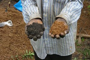
A farming technique practised for centuries by villagers in West Africa, which converts nutrient-poor rainforest soil into fertile farmland, could be the answer to mitigating climate change and revolutionising farming across Africa.
A global study, led by the University of Sussex, which included anthropologists and soil scientists from Cornell, Accra, and Aarhus Universities and the Institute of Development Studies, has for the first-time identified and analysed rich fertile soils found in Liberia and Ghana.
They discovered that the ancient West African method of adding charcoal and kitchen waste to highly weathered, nutrient poor tropical soils can transform the land into enduringly fertile, carbon-rich black soils which the researchers dub ‘African Dark Earths’.
From analysing 150 sites in northwest Liberia and 27 sites in Ghana researchers found that these highly fertile soils contain 200-300 percent more organic carbon than other soils and are capable of supporting far more intensive farming.
Professor James Fairhead, from the University of Sussex, who initiated the study, said: “Mimicking this ancient method has the potential to transform the lives of thousands of people living in some of the most poverty and hunger stricken regions in Africa.
“More work needs to be done but this simple, effective farming practice could be an answer to major global challenges such as developing ‘climate smart’ agricultural systems which can feed growing populations and adapt to climate change.”
Similar soils created by Amazonian people in pre-Columbian eras have recently been discovered in South America — but the techniques people used to create these soils are unknown. Moreover, the activities which led to the creation of these anthropogenic soils were largely disrupted after the European conquest.
Encouragingly researchers in the West Africa study were able to live within communities as they created their fertile soils. This enabled them to learn the techniques used by the women from the indigenous communities who disposed of ash, bones and other organic waste to create the African Dark Earths.
Dr Dawit Solomon, the lead author from Cornell University, said: “What is most surprising is that in both Africa and in Amazonia, these two isolated indigenous communities living far apart in distance and time were able to achieve something that the modern-day agricultural management practices could not achieve until now.
“The discovery of this indigenous climate smart soil-management practice is extremely timely. This valuable strategy to improve soil fertility while also contributing to climate-change mitigation and adaptation in Africa could become an important component of the global climate-smart agricultural management strategy to achieve food security.”
Reference:
Dawit Solomon, Johannes Lehmann, James A Fraser, Melissa Leach, Kojo Amanor, Victoria Frausin, Søren M Kristiansen, Dominique Millimouno, James Fairhead. Indigenous African soil enrichment as a climate-smart sustainable agriculture alternative. Frontiers in Ecology and the Environment, 2016; 14 (2): 71 DOI: 10.1002/fee.1226
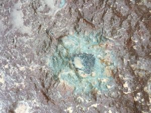
A meteorite discovered in a Swedish quarry is unique and distinct from other meteorites. It appears to be a relic of a massive collision in the asteroid belt 470 million years ago that send debris raining to Earth during the Ordovician Period. In this image, the black ‘fossil’ meteorite is preserved in slate from the quarry. Credit: Qing-zhu Yin, UC Davis
An ancient space rock discovered in a Swedish quarry is a type of meteorite never before found on Earth, scientists reported June 14 in the journal Nature Communications.
“In our entire civilization, we have collected over 50,000 meteorites, and no one has seen anything like this one before,” said study co-author Qing-zhu Yin, professor of geochemistry and planetary sciences at the University of California, Davis. “Discovering a new type of meteorite is very, very exciting.”
The new meteorite, called Ost 65, appears to be from the missing partner in a massive asteroid collision 470 million years ago. The collision sent debris falling to Earth over about a million years and may have influenced a great diversification of life in the Ordovician Period. One of the objects involved in this collision is well-known: It was the source of L-chondrites, still the most common type of meteorite. But the identity of the object that hit it has been a mystery.
Ost 65 was discovered in Sweden’s Thorsberg quarry, source of more than 100 fossil meteorites. Measuring just under 4 inches wide, it looks like a gray cow patty plopped into a pristine layer of fossil-rich pink limestone. The Ost 65 rock is called a fossil meteorite because the original rock is almost completely altered except for a few hardy minerals — spinels and chromite. Analyses of chromium and oxygen isotopes in the surviving minerals allowed the researchers to conclude the Ost 65 meteorite is chemically distinct from all known meteorite types.
By measuring how long Ost 65 was exposed to cosmic rays, the team established that it traveled in space for about a million years before it fell to Earth 470 million years ago. This timeline matches up with L-chondrite meteorites found in the quarry, leading the study authors to suggest the rock is a fragment of the other object from the Ordovician collision. The original object may have been destroyed during the collision, but it’s also possible that the remains are still out in space.
Meteorites may have influenced evolution
Researchers think that about 100 times as many meteorites slammed into Earth during the Ordovician compared with today, thanks to the massive collision in the asteroid belt. This rain of meteorites may have opened new environmental niches for organisms, thus boosting both the diversity and complexity of life on Earth.
“I think this shows the interconnectedness of the entire solar system in space and time, that a random collision 470 million years ago in the asteroid belt could dictate the evolutionary path of species here on Earth,” Yin said.
The study was led by Birger Schmitz, of Lund University in Sweden. Yin, of UC Davis, together with his postdoctoral fellow Matthew Sanborn, made the very precise measurement of chromium in tiny mineral grains within the meteorite. Researchers from the University of Hawaii at Manoa analyzed its oxygen isotopes.
The new findings strengthen suspicions that more recent meteorite falls on Earth do not represent the full range of rocks drifting through the solar system. Yin said there is potential to better understand the history of our solar system by collecting meteorite fragments preserved in Earth’s ancient rocks. “If we can go back even further in time, we may eventually be able to find some of the true building blocks of Earth,” Yin said.
Reference:
B. Schmitz, Q. -Z. Yin, M. E. Sanborn, M. Tassinari, C. E. Caplan & G. R. Huss. A new type of solar-system material recovered from Ordovician marine limestone. DOI:10.1038/ncomms11851
Denizens of the deep 210 million years ago near Bristol. An ichthyosaur sizes up the armoured fish, Dapedium, at bottom left. Sharks and ammonites swim in the background in tropical seas Credit: Drawing by Valentina Rossi, one of the lead authors of the work
A team from the University of Bristol has shed new light on the creatures that inhabited the tropical seas surrounding Britain at the start of the age of the dinosaurs.
Some 210 million years ago, Britain consisted of many islands, surrounded by warm seas. Europe at the time lay farther south, at latitudes equivalent to North Africa today. Much of Europe was hot desert, and at this point was flooded by a great sea – the Rhaetian Transgression.
Published in Proceedings of the Geologists’ Association, the Bristol team’s work is the most extensive study yet, based on more than 26,000 identified fossils, of the Rhaetian shallow sea sharks, bony fishes, marine reptiles, and other creatures. Unusually, five members of the team were undergraduates when they did the work, and this was part of a series of summer internships.
The team was led by Ellen Mears, now a postgraduate at the University of Edinburgh, and Valentina Rossi, now a postgraduate at the University of Cork.
Ellen Mears said: “I studied the shark and fish teeth, and found remains of at least seven species of sharks and four of bony fishes. The sharks were all predators, but some were quite small. The bony fishes were unusual because many of them were shell crushers.”
Valentina Rossi, who worked on the reptile remains, added: “We found teeth and bones of ichthyosaurs and plesiosaurs, the classic great sea dragons of the Triassic and Jurassic, as well as some other reptiles, including a tooth possibly from a dinosaur – but it was heavily worn.”
Professor Michael Benton, who supervised the students’ work over the summers of 2014 and 2015, explained: “The students came to the project with no prior knowledge, but each one took on the task of identifying and documenting their group of fossils. They had to look at thousands of specimens and assign them to species, and then each contribute their part of the paper to proper professional standards. This is the eighth paper published from this internship scheme.”
The new work has emphasized the complexity of major global changes, like this remarkable rise in sea level ten million years ago. It has been documented from dozens of localities in England, but also from central Europe. Careful measurement of the rock sections, and documentation of the fossils bed-by-bed allow us to reconstruct the to-and-fro of major animal groups over a few million years.
The fossils even include dozens of examples of coprolites, pellets of dung, hat were deposited by the various fishes and reptiles – some of these even contain bones and scales of fishes, and one even shows small bones of a marine reptile – clear evidence of who was eating whom in those ancient seas.
Reference:
‘The Rhaetian (Late Triassic) vertebrates of Hampstead Farm Quarry, Gloucestershire, UK’ by Ellen Mears, Valentina Rossi, Ellen MacDonald, Gareth Coleman, Tom Davies, Caterina Arias-Riesgo, Claudia Hildebrandt, Helen Thiel, Christopher J. Duffin, David I. Whiteside, and Michael J. Benton in Proceedings of the Geologists’ Association. DOI:10.1016/j.pgeola.2016.05.003
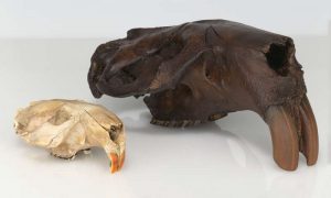
The first fossil skull of Castoroides ohioensis found in 1845 alongside the skull of a modern beaver. Credit: New York State Museum
A few snippets of protein extracted from the fossil of an extinct species of giant beaver are opening a new door in paleoproteomics, the study of ancient proteins. Ancient proteins can be used to place animals on the evolutionary tree, and could offer insights into how life and Earth’s environment have evolved over time. Typically, paleoproteomics relies on fossils collected for the purpose. But in a paper published today in the Proceedings of the Royal Society B, researchers at Rensselaer Polytechnic Institute (RPI) used a fossil collected more than 170 years ago in central New York, and housed at the New York State Museum.
“Paleoproteomics is a young field. We don’t yet know the full potential of the information it may offer us, and one barrier to that is the supply of fossils we can call upon for research,” said Deepak Vashishth, professor of biomedical engineering and director of the Rensselaer Center for Biotechnology and Interdisciplinary Studies. “In developing these techniques, we’re creating new value in fossils that are already on exhibit, or sitting in storage waiting for a purpose.”
The team of researchers extracted proteins from the first skull of the species Castoroides ohioensis ever found. Collected in 1845, the giant beaver skull is the oldest museum-curated bony specimen to have been studied using paleoproteomic tools. The researchers were searching for proteins, chains of amino acids assembled from instructions encoded in DNA that perform a wide variety of functions in living organisms. Using mass spectrometry analysis, researchers detected many samples of collagen 1, the most common protein in bone.
“This research not only provides exciting information about a New York State Museum specimen of unique significance—the first discovered and documented giant beaver skull in the world—it also highlights the critical role museum collections play in research and discovery,” said Robert Feranec, New York State Museum curator of vertebrate paleontology. “Without maintaining collections rich in diversity of specimens, both ancient and modern, similar research that examines these windows into our past would not be possible.”
The big challenge to drawing upon existing fossil collections is that they weren’t collected for the purpose of paleoproteomics, and they may not have been stored in conditions optimal to protein extraction and analysis techniques, said Timothy Cleland, a postdoctoral researcher formerly at Rensselaer Polytechnic Institute and now at the University of Texas-Austin.
“In paleoproteomics we’ve generally looked at specimens collected recently and carefully stored in climate-controlled conditions. In this case, we’re looking at a specimen that sat on a shelf collecting dust for most of its life,” Cleland said. “So we wanted to know – can we look at these historically collected specimens and pull out protein information?”
When researchers studied the giant beaver skull, the first thing they noticed was that it appeared to have varnish, a common treatment used to preserve fossils, applied to the outside of it. To avoid the varnish (which is itself organically based), they took samples from the nasal cavities of the skull. They removed a small sample of bone, extracted the preserved proteins, digested with enzyme, and analyzed the protein pieces with mass spectrometry.
The analysis determined the primary sequence of amino acids in the protein detected, as well as post-translational modifications, chemical changes on the surface of the protein that are not defined by DNA. Both the primary sequence and post-translational modifications have value to researchers, and that value will increase as more specimens are analyzed and more information becomes available, said Cleland.
A database of primary protein sequences, for example, could be useful in clarifying evolutionary trees, in reverse engineering proteins to understand how particular proteins evolved over a period of time, or in “reviving” a sequence that may be nonexistent now for therapeutic use.
Cleland was particularly excited about being able to detect fossil post-translational modifications, a finding that has little precedent in the emerging field. Post-translational modifications are such a recent addition to paleoproteomics that he said researchers are just scratching the surface of what can be done with it.
“Collagen, for example, is a really long-lived protein – we retain some of the collagen we’re born with for our entire lives. By studying the post-translational modifications to collagen, we can learn what an organism is doing to its collagen so it can function better – for example become more rigid or more flexible,” said Cleland. “Now imagine if we were able to build up a database of post-translational modification to ancient organisms, we could begin to make inferences about evolutionary changes, or use them in protein engineering to look at how function in the ancient protein compares to that same protein in living animals.”
At Rensselaer, the research exemplifies the work being done at The New Polytechnic, addressing difficult and complex global challenges, the need for interdisciplinary and true collaboration, and the use of the latest tools and technologies, many of which are developed at Rensselaer.
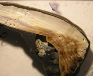
Cross section of a mussel shell showing its thickness. The holes show where samples were drilled to analyze its composition. Credit: Cathy Pfister, University of Chicago
Shells of California mussels collected from the Pacific Ocean off the coast of Washington in the 1970s are on average 32 percent thicker than modern specimens, according to a new study published by University of Chicago biologists.
Shells collected by Native Americans 1,000 to 1,300 years ago were also 27 percent thicker than modern shells, on average. The decreasing thickness over time, in particular the last few decades, is likely due to ocean acidification as a result of increased carbon in the atmosphere.
“Archival material provided by past researchers, the Makah Tribal Nation, and the Olympic National Park allowed us to document this intriguing and concerning pattern in shell thickness,” said Cathy Pfister, PhD, professor of ecology and evolution at the University of Chicago and lead author. The study was published June 15, 2016, in the Proceedings of the Royal Society B.
As humans burn fossils fuels, the oceans absorb a large portion of the additional carbon released into the atmosphere. This in turn causes pH levels of ocean water to drop, making it more acidic. Mussels, oysters, and certain species of algae have difficulty producing their calcium carbonate shells and skeletons in such an environment, and can provide an early indicator of how increasing ocean acidification affects marine life.
In previous studies, Pfister and her colleagues documented declining pH levels in the waters surrounding Tatoosh Island off the coast of Washington state. In 2011 they further analyzed carbon and oxygen isotopes taken from modern mussel shells, shells collected by the local Makah tribe between AD 668 and 1008, and shells collected by biologists in the 1970s.
For the new study, the researchers compared the thicknesses of the same sets of shells. On average, the shells provided by the Makah Cultural and Research Center were 27.6 percent thicker than modern counterparts. Shells from the 1970s were 32.2 percent thicker. Shells collected from a different Native American site in Sand Point, WA, dating between 2150 and 2420 years old were almost 94 percent thicker than modern shells.
The long-term decline in thickness likely shows a response to ocean acidification, though the researchers also consider other environmental drivers including changes in food supply (e.g. plankton) for mussels.
The researchers also point out that their findings raise concerns about the California mussel’s ability to retain its role as a foundational species in these waters. Decreased shell thickness makes them increasingly vulnerable to predators and environmental disturbances. This in turn could affect interactions with hundreds of other species of organisms that live near mussel beds in tidal waters.
“The California mussel is a common species along the entire west coast of the United States, and their fate will be linked to that of a rich diversity of predators, including sea stars and sea otters, as well as myriad species that are part of the mussel bed habitat,” Pfister said. “It is imperative that we understand more about how these species will change as ocean conditions change.”
Reference:
Historical baselines and the future of shell calcification for a foundation species in a changing ocean, Proceedings of the Royal Society B, DOI: 10.1098/rspb.2016.0392
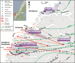
Distribution of olivine fabrics in the Western Gneiss Region in Norway (modified after Wang et al., 2013b).
The homologous temperature of a crystalline material is defined as the ratio between temperature and the melting (solidus) temperature (Tm) in Kelvin. Because Tm of a crystalline material is controlled by the bonding force between atoms, T/Tm has been widely used to compare the creep strength of crystalline materials. As the most abundant mineral in the upper mantle, olivine is the solid solution of forsterite (Mg2SiO4) and fayalite (Fe2SiO4). Recent deformation experiments have revealed the influence of water, temperature, pressure, stress and partial melting on fabric development of olivine. However, how to extrapolate laboratory results to mantle deformation is still under debate.
In a recent review in Science China Earth Sciences, Qin Wang from Nanjing University established the phase diagram of dry olivine up to 6.4 GPa using previous melting experiments and generalized means. She found that the change of T/Tm of olivine with depth allows comparison with the strength of the upper mantle under different thermal states and olivine compositions. The transition from semi-brittle to ductile deformation in the upper mantle occurs at a depth where T/Tm of olivine equals to 0.5.
In addition, T/Tm is used to analyze fabric transitions of olivine. The results indicate that the effect of water on olivine fabrics is closely related with pressure. Below 6.4 GPa (less than 200 km) and under the strain rate and low stress in the upper mantle, the [100](010) slip system (A-type fabric) becomes dominant when T/Tm > 0.55-0.60. When T/Tm < 0.55-0.60, [001] slip is easier. Low T/Tm favors the operation of [001](100) slip system (C-type fabric). This is consistent with the widely observed A-type fabric in naturally deformed peridotites, and the C-type fabric in peridotites that experience deep subduction in ultra-high-pressure metamorphic terranes. However, the [001](010) slip system (B-type fabric) will develop under high stress and relatively low T/Tm.
This study provides new information on tracing mantle flow from seismic anisotropy. Seismic anisotropy of the upper mantle is controlled by the A-type fabric of olivine in most regions, where the fastest P-wave velocity and the polarization direction of the faster S-wave velocity are parallel to the mantle flow direction. However, olivine in subduction zones may develop the B- or C-type fabric, making the fastest P-wave velocity and the polarization direction of the faster S-wave velocity normal to the mantle flow direction. Seismic anisotropy of the upper mantle beneath cratons can be simulated using a four-layer model with different fabrics.
It is noteworthy that when pressure is higher than 6.4 GPa, the melting behavior of iron-rich olivine and the incorporation mechanism of hydrogen in olivine are different from those at low pressure. The lack of melting experiments on hydrogen-bearing olivine at high pressure hampers our estimation of its homologous temperature. Such knowledge will improve our understanding of the role of water in mantle rheology and planetary evolution.
Reference:
Qin Wang, Homologous temperature of olivine: Implications for creep of the upper mantle and fabric transitions in olivine, Science China Earth Sciences (2016). DOI: 10.1007/s11430-016-5310-z
Note: The above post is reprinted from materials provided by Science China Press.
In this photo, workers repair earthquake damage in Kathmandu’s ancient Swayambunath Temple. Credit: Rebecca Bendick
A University of Montana researcher is part of a team whose research is breaking ground on the complexity of earthquakes and the possibility to forecast them.
Rebecca Bendick, who works in UM’s Department of Geosciences, used GPS records of surface motion to map the 7.8 magnitude Gorkha earthquake, which broke a 150-kilometer section of the Himalayas in April 2015, terminating close to Kathmandu.
“Measuring this earthquake tells us that the past history of great Himalayan earthquakes is much more complicated than previously thought,” Bendick said.
The Gorkha earthquake failed to rupture the Himalayan faults all the way to the surface. But rapid initial afterslip occurred north of the earthquake under Tibet during the first six months following the quake, releasing aseismic-moment equivalent to a magnitude 7.1 earthquake.
Similar “incomplete” historical earthquakes have occurred in the Himalayas in 1803, 1833, 1905 and 1947.
Bendick said this study shows rather than just rare and extremely large quakes doing all the work, a mixture of smaller and larger quakes cause the Himalayas to edge over India.
“This means our ability to forecast earthquake hazards in the region is even worse than we thought,” she said. “The most important and practical message is that residents of the region should be prepared for more frequent, but perhaps less catastrophic quakes.”
The area just west of the Gorkha quake, spanning western Nepal and the Indian Himalaya has a very high earthquake hazard, Bendick said, with potential for either a large quake or megaquake.
“The pervasive lack of information transfer from earthquake research to people living in zones of high earthquake hazard has led to hundreds of thousands of fatalities in the past decade, a crisis unlikely to change in the future unless basic earthquake literacy is provided to those at risk,” Bendick said.
Reference:
David Mencin, Rebecca Bendick, Bishal Nath Upreti, Danda Pani Adhikari, Ananta Prasad Gajurel, Roshan Raj Bhattarai, Hari Ram Shrestha, Tara Nidhi Bhattarai, Niraj Manandhar, John Galetzka, Ellen Knappe, Beth Pratt-Sitaula, Abdelkrim Aoudia, Roger Bilham. Himalayan strain reservoir inferred from limited afterslip following the Gorkha earthquake. Nature Geoscience, 2016; DOI: 10.1038/ngeo2734
Global emissions of ethane, an air pollutant and greenhouse gas, are on the uptick again, according to a new study led by the University of Colorado Boulder.
The team found that a steady decline of global ethane emissions following a peak in about 1970 ended between 2005 and 2010 in most of the Northern Hemisphere and has since reversed, said CU-Boulder Associate Research Professor Detlev Helmig, lead study author. Between 2009 and 2014, ethane emissions in the Northern Hemisphere increased by about 400,000 tons annually, the bulk of it from North American oil and gas activity, he said.
The decline of ethane and other non-methane hydrocarbons (NMHC) starting around 1970 is believed to be primarily due to better emission controls, said Helmig. The controls resulted in reduced emissions from oil and gas production, storage and distribution, as well as combustion exhaust from cars and trucks.
“About 60 percent of the drop we saw in ethane levels over the past 40 years has already been made up in the past five years,” said Helmig. “If this rate continues, we are on track to return to the maximum ethane levels we saw in the 1970s in only about three more years. We rarely see changes in atmospheric gases that quickly or dramatically.”
Ethane, propane and a host of other NMHCs are released naturally by the seepage of fossil carbon deposits, volcanic activity and wildfires, said Helmig. But human activities, which also include biomass burning and industrial use, constitute the most dominant source of the NMHCs worldwide.
“These human sources make up roughly three-quarters of the atmospheric ethane that is being emitted,” said Helmig.
The air samples for the study were collected from more than 40 sites around the world, from Colorado and Greenland to Germany, Switzerland, New Zealand and Earth’s polar regions. More than 30,000 soda bottle-sized air containers were sampled at the National Oceanic and Atmospheric Administration’s (NOAA) Earth Systems Research Laboratory (ESRL) in Boulder over the past decade.
The study also showed that among the air sampling locations around the world, the largest increases in ethane and shorter-lived propane were seen over the central and eastern United States, areas of heavy oil and gas activity, said Helmig.
“We concluded that added emissions from U.S. oil and gas drilling have been the primary source for the atmospheric ethane trend reversal,” he said.
The study, published in Nature Geoscience, also indicated that emissions of total NMHC in the Northern Hemisphere are now increasing by roughly 1.2 million tons annually.
The findings from the flask network, which INSTAAR and NOAA have been operating for more than 10 years, were supported by additional measurements showing very similar ethane behavior from a number of continuous global monitoring sites, he said.
A component of natural gas, ethane plays an important role in Earth’s atmosphere. As it breaks down near Earth’s surface it can create ground-based ozone pollution, a health and environmental risk.
Chemical models by the team show that the increase in ethane and other associated hydrocarbons will likely cause additional ground-based ozone production, particularly in the summer months, he said.
“Ethane is the second most significant hydrocarbon emitted from oil and gas after methane,” said Helmig. “Other studies show on average there is about 10 times as much methane being emitted by the oil and gas industry as ethane.”
“There is high interest by scientists in methane since it is a strong greenhouse gas,” said Helmig. The new findings on ethane increases indicate there should be more research on associated methane emissions.
Reference:
Detlev Helmig, Samuel Rossabi, Jacques Hueber, Pieter Tans, Stephen A. Montzka, Ken Masarie, Kirk Thoning, Christian Plass-Duelmer, Anja Claude, Lucy J. Carpenter, Alastair C. Lewis, Shalini Punjabi, Stefan Reimann, Martin K. Vollmer, Rainer Steinbrecher, James W. Hannigan, Louisa K. Emmons, Emmanuel Mahieu, Bruno Franco, Dan Smale, Andrea Pozzer. Reversal of global atmospheric ethane and propane trends largely due to US oil and natural gas production. Nature Geoscience, 2016; DOI: 10.1038/ngeo2721
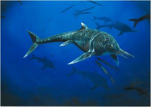
A new type of ichthyosaur, an extinct marine reptile alive at the same time as the dinosaurs, has been identified by a Manchester palaeontologist from a fossil found in an old quarry in Nottinghamshire.
Similar-shaped to dolphins and sharks, ichthyosaurs — often misidentified as ‘swimming dinosaurs’ — swam the seas of Earth for millions of years during the Triassic, Jurassic and Cretaceous periods. The Nottinghamshire fossil is from the earliest part of the Jurassic Period — 200 million years ago — and only a handful of ichthyosaur species are known from this period, making the discovery very significant. It is also the first time a species of this geological age has been found outside of Dorset and Somerset.
Dean Lomax, a Palaeontologist and Honorary Scientist at The University of Manchester, examined the specimen after seeing it on a visit to Leicester’s New Walk Museum, which acquired the fossil in 1951, and spotted some unusual features. The specimen is relatively complete, consisting of a partial skeleton including a skull, pectoral bones, limbs, pelvis bones, ribs and vertebrae. However, the bones are disorderly — it appears that the carcass ‘nosedived’ into the seabed before it became fossilised, which may have restricted previous study.
“When I first saw this specimen, I knew it was unusual,” said Dean. “It displays features in the bones — especially in the coracoid (part of the pectoral girdle) — that I had not seen before in Jurassic ichthyosaurs anywhere in the world. The specimen had never been published, so this rather unusual individual had been awaiting detailed examination.”
Dr Mark Evans, Palaeontologist and Curator of Natural Sciences at New Walk Museum, said: “Parts of the skeleton had previously been on long-term loan to ichthyosaur specialist and former museum curator Dr Robert Appleby, and had only returned to the museum in 2004 after he sadly passed away. He was clearly intrigued by the specimen, and although he worked on it for many years, he had identified it as a previously known species but never published his findings.”
Dean has named the new species Wahlisaurus massarae in honour of two palaeontologists (Professor Judy Massare and Bill Wahl) who have contributed significantly to the study of ichthyosaurs, and who first introduced Dean to studying them.
“Both Judy and Bill have been tremendous mentors for me. They have significantly contributed to palaeontology, especially the study of ichthyosaurs, and I cannot think of a better way to remember them by naming this new ichthyosaur in their honour. Their names will be set in stone forever, pun intended!”
The specimen is the first new genus of ichthyosaur from the British Early Jurassic to be described since 1986. Thousands of specimens from this time are known, and many of these have been examined — and continue to be re-examined in light of new knowledge and technologies. However, as the specimen is from a practically unknown location for the discovery of ichthyosaurs, any new discovery could be of real scientific significance. This new species is also important for our understanding of ichthyosaur species diversity, and their geographical distribution during the Early Jurassic.
Reference:
Dean R. Lomax. A new leptonectid ichthyosaur from the Lower Jurassic (Hettangian) of Nottinghamshire, England, UK, and the taxonomic usefulness of the ichthyosaurian coracoid. Journal of Systematic Palaeontology, 2016; 1 DOI: 10.1080/14772019.2016.1183149
Ludwig Maximilian University of Munich researchers have shown that volcanic lightning results from the discharge of static electricity accumulated by ash particles in the rising plume. Observations of such flashes could help to forecast the impact of volcanic eruptions.
Mount Sakurajima on the Japanese island of Kyushu is one of the most active volcanoes in the world. The huge clouds of gas, ash and rock fragments which the volcano spews into the atmosphere during its highly explosive eruptive phases are often illuminated by volcanic lightning – a striking phenomenon that remains poorly understood. Volcanologist Corrado Cimarelli and his group in the Department of Earth and Environmental Sciences at LMU recently made a detailed study of the lightning flashes that accompany Sakurajima’s frequent outbursts.
The team now reports that friction generated by collisions between the ash particles in the turbulent jets that form the plume invests the particles with sufficient electrostatic charge to account for the lightning observed during eruptions. They also show that the frequency of the flashes varies with the amount of ash emitted during an eruption. This correlation suggests that monitoring of volcanic lightning could provide a means of determining the size distribution of the ash clouds released into the atmosphere during eruptions – and permit improved forecasting of their potential impact on air traffic. The findings appear in the journal Geophysical Research Letters, and the work is featured on the cover of the latest issue.
“We used video footage of eruptions of Sakurajima obtained with a high-speed camera as the basis for our study, and combined these images with measurements of changes in the electromagnetic field and with data recorded by acoustic sensors,” says Cimarelli. Analysis of the resulting data allowed the researchers to determine that volcanic lightning flashes are largely restricted to the lower levels of the plume, i.e., within a few hundred meters above the crater’s rim. In this region, particle fragmentation within the turbulent magma electrifies the rising ash particles, and the accumulated electrostatic charge is subsequently explosively discharged in the form of lightning. In contrast to normal lightning which originates at greater heights, volcanic lightning flashes do not require the presence of ice crystals as nucleation centers.
The researchers argue convincingly that monitoring of volcanic lightning would facilitate assessment of the overall impact of volcanic eruptions: “Independently of the size of the eruption, every episode of ash emission is associated with electrical discharges,” says Cimarelli. “This is a parameter that can be measured – from a distance of several kilometers away and under conditions of poor visibility – and it can be used as a proxy to estimate the total mass and the size distribution of the ash deposited in the atmosphere. This would enable us to rapidly assess the distribution of ash particles in the atmosphere and if necessary alert the aviation authorities.”
Reference:
C. Cimarelli et al. Multiparametric observation of volcanic lightning: Sakurajima Volcano, Japan, Geophysical Research Letters (2016). DOI: 10.1002/2015GL067445