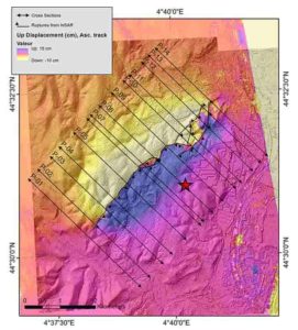
On 11 November 2019, a magnitude 5 earthquake occurred near the village of Le Teil in the Rhône River Valley in southern France producing an unexpected surface rupture with ground displacement.
For the first time in France, the CNRS, IRSN, IRD, Université de Montpellier, Université Côte d’Azur and Terradue (1) had the opportunity to use all modern seismological, geodetical (2), and geological techniques available to study this historically unprecedented seismic event. The data, published on 27 August 2020 in Communications Earth & Environment, reveals that the earthquake was caused by the reactivation of the ancient La Rouvière fault. The fault formed during an extensional tectonic period some 20-30 million years ago during the Oligocene epoch, and was no longer considered to be active.
During the Le Teil earthquake, the fault experienced a reverse faulting movement (compression) with an average surface displacement of about 10cm both vertically and horizontally. Scientists estimate that the event nucleated at a shallow focal depth of approximately 1km, which explains why the rupture along the fault was able to reach the surface and cause considerable damage despite the moderate-magnitude (3) (the accurate position of the earthquake’s focus is presently being studied by another research team).
The results raise the possibility that other faults could be reactivated in France and Western Europe and produce surface displacements, whereas the risk of earthquakes with surface rupture was until now considered as highly improbable. To better assess the probability of such events, several teams of scientists in France are performing palaeoseismological investigations looking for evidence of past earthquakes along such faults.
Notes:
(1) Members of Géosciences Montpellier (CNRS/Université de Montpellier/Université des Antilles), Géoazur (CNRS/Observatoire de la Côte d’Azur/IRD/Université Côte d’Azur), Isterre (CNRS/IRD/Université Grenoble Alpes/Université Savoie Mont Blanc/Université Gustave Eiffel) laboratories participated in this study, along with IRSN (France) and the company Terradue (Italy).
(2) Geodesy is the study, usually with the aid of satellite observations, of the shape and deformations of the surface of the Earth.
(3) Only 10% of earthquakes of this magnitude cause surface rupture.
Reference:
Jean-François Ritz, Stéphane Baize, Matthieu Ferry, Christophe Larroque, Laurence Audin, Bertrand Delouis, Emmanuel Mathot. Surface rupture and shallow fault reactivation during the 2019 Mw 4.9 Le Teil earthquake, France. Communications Earth & Environment, 2020; 1 (1) DOI: 10.1038/s43247-020-0012-z
Note: The above post is reprinted from materials provided by CNRS.


