In newly published research, an international team of geologists, geophysicists, and mathematicians show how coupled computer models can accurately recreate the conditions leading to the world’s deadliest natural disasters of 2018, the Palu earthquake and tsunami, which struck western Sulawesi, Indonesia in September last year. The team’s work was published in Pure and Applied Geophysics.
The tsunami was as surprising to scientists as it was devastating to communities in Sulawesi. It occurred near an active plate boundary, where earthquakes are common. Surprisingly, the earthquake caused a major tsunami, although it primarily offset the ground horizontally — normally, large-scale tsunamis are typically caused by vertical motions.
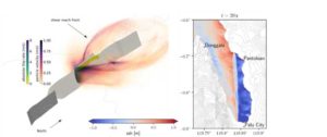
Researchers were at a loss — what happened? How was the water displaced to create this tsunami: by landslides, faulting, or both? Satellite data of the surface rupture suggests relatively straight, smooth faults, but do not cover areas offshore, such as the critical Palu Bay. Researchers wondered — what is the shape of the faults beneath Palu Bay and is this important for generating the tsunami? This earthquake was extremely fast. Could rupture speed have amplified the tsunami?
Using a supercomputer operated by the Leibniz Supercomputing Centre, a member of the Gauss Centre for Supercomputing, the team showed that the earthquake-induced movement of the seafloor beneath Palu Bay itself could have generated the tsunami, meaning the contribution of landslides is not required to explain the tsunami’s main features. The team suggests an extremely fast rupture on a straight, tilted fault within the bay. In their model, slip is mostly lateral, but also downward along the fault, resulting in anywhere from 0.8 metres to 2.8 metres vertical seafloor change that averaged 1.5 metres across the area studied. Critical to generating this tsunami source are the tilted fault geometry and the combination of lateral and extensional strains exerted on the region by complex tectonics.
The scientists come to this conclusion using a cutting-edge, physics-based earthquake-tsunami model. The earthquake model, based on earthquake physics, differs from conventional data-driven earthquake models, which fit observations with high accuracy at the cost of potential incompatibility with real-world physics. It instead incorporates models of the complex physical processes occurring at and off of the fault, allowing researchers to produce a realistic scenario compatible both with earthquake physics and regional tectonics.
The researchers evaluated the earthquake-tsunami scenario against multiple available datasets. Sustained supershear rupture velocity, or when the earthquake front moves faster than the seismic waves near the slipping faults, is required to match simulation to observations. The modeled tsunami wave amplitudes match the available wave measurements and the modeled inundation elevation (defined as the sum of the ground elevation and the maximum water height) qualitatively match field observations. This approach offers a rapid, physics-based evaluation of the earthquake-tsunami interactions during this puzzling sequence of events.
“Finding that earthquake displacements probably played a critical role generating the Palu tsunami is as surprising as the very fast movements during the earthquake itself,” said Thomas Ulrich, PhD student at Ludwig Maximilian University of Munich and lead author of the paper. “We hope that our study will launch a much closer look on the tectonic settings and earthquake physics potentially favouring localized tsunamis in similar fault systems worldwide.”
Reference:
T. Ulrich, S. Vater, E. H. Madden, J. Behrens, Y. van Dinther, I. van Zelst, E. J. Fielding, C. Liang, A.-A. Gabriel. Coupled, Physics-Based Modeling Reveals Earthquake Displacements are Critical to the 2018 Palu, Sulawesi Tsunami. Pure and Applied Geophysics, 2019; DOI: 10.1007/s00024-019-02290-5
Note: The above post is reprinted from materials provided by Gauss Centre for Supercomputing.


