The Silurian is a geologic period and system that extends from the end of the Ordovician Period, about 443.4 ± 1.5 million years ago (mya), to the beginning of the Devonian Period, about 419.2 ± 3.2 mya (ICS, 2004). As with other geologic periods, the rock beds that define the period’s start and end are well identified, but the exact dates are uncertain by several million years. The base of the Silurian is set at a major extinction event when 60% of marine species were wiped out. See Ordovician-Silurian extinction events.
A significant evolutionary milestone during the Silurian was the diversification of jawed and bony fish. Life also began to appear on land in the form of small, moss-like, vascular plants which grew beside lakes, streams, and coastlines, and also in the form of small terrestrial arthropods. However, terrestrial life would not greatly diversify and affect the landscape until the Devonian.
History of study
The Silurian system was first identified by British geologist Sir Roderick Impey Murchison, who was examining fossil-bearing sedimentary rock strata in south Wales in the early 1830s. He named the sequences for a Celtic tribe of Wales, the Silures, inspired by his friend Adam Sedgwick, who had named the period of his study the Cambrian, the Latin name for Wales. This naming does not indicate any correlation between the occurrence of the Silurian rocks and the land inhabited by the Silures; cf. Geology of Wales, Tribes of Wales. In 1835 the two men presented a joint paper, under the title On the Silurian and Cambrian Systems, Exhibiting the Order in which the Older Sedimentary Strata Succeed each other in England and Wales, which was the germ of the modern geological time scale. As it was first identified, the “Silurian” series when traced farther afield quickly came to overlap Sedgwick’s “Cambrian” sequence, however, provoking furious disagreements that ended the friendship. Charles Lapworth resolved the conflict by defining a new Ordovician system including the contested beds. An early alternative name for the Silurian was “Gotlandian” after the strata of the Baltic island of Gotland.
The French geologist Joachim Barrande, building on Murchison’s work, used the term Silurian in a more comprehensive sense than was justified by subsequent knowledge. He divided the Silurian rocks of Bohemia into eight stages. His interpretation was questioned in 1854 by Edward Forbes, and the later stages of Barrande, F, G and H, have since been shown to be Devonian. Despite these modifications in the original groupings of the strata, it is recognized that Barrande established Bohemia as a classic ground for the study of the earliest fossils.
Subdivisions
Llandovery
The Llandovery Epoch lasted from 443.4 ± 1.5 to 433.4 ± 2.8 mya, and is subdivided into three stages: the Rhuddanian, lasting until 440.8 million years ago, the Aeronian, lasting to 438.5 million years ago, and the Telychian. The epoch is named for the town of Llandovery in Carmarthenshire, Wales.
Wenlock
The Wenlock, which lasted from 433.4 ± 1.5 to 427.4 ± 2.8 mya, is subdivided into the Sheinwoodian (to 430.5 million years ago) and Homerian ages. It is named after Wenlock Edge in Shropshire, England. During the Wenlock, the oldest known tracheophytes of the genus Cooksonia, appear. The complexity of slightly younger Gondwana plants like Baragwanathia indicates a much longer history for vascular plants, perhaps extending into the early Silurian or even Ordovician. See Evolutionary history of plants. The first terrestrial animals also appear in the Wenlock, represented by air-breathing millipedes from Scotland.
Ludlow
The Ludlow, lasting from 427.4 ± 1.5 to 423 ± 2.8 mya, comprises the Gorstian stage, lasting until 425.6 million years ago, and the Ludfordian stage. It is named for the town of Ludlow in Shropshire, England.
Přídolí
The Pridoli, lasting from 423 ± 1.5 to 419.2 ± 2.8 mya, is the final and shortest epoch of the Silurian. It is named after one locality at the Homolka a Přídolí nature reserve near the Prague suburb Slivenec in the Czech Republic. Přídolí is the old name of a cadastral field area.
Regional stages
In North America a different suite of regional stages is sometimes used:
- Cayugan (Late Silurian – Ludlow)
- Lockportian (middle Silurian: late Wenlock)
- Tonawandan (middle Silurian: early Wenlock)
- Ontarian (Early Silurian: late Llandovery)
- Alexandrian (earliest Silurian: early Llandovery)
Geography
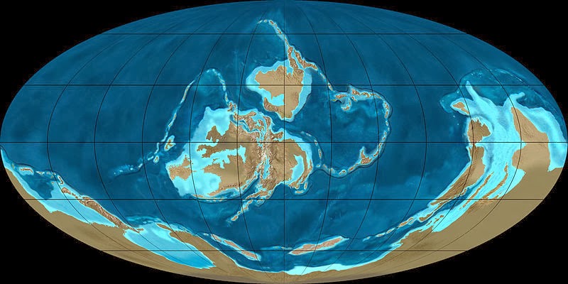
With the supercontinent Gondwana covering the equator and much of the southern hemisphere, a large ocean occupied most of the northern half of the globe. The high sea levels of the Silurian and the relatively flat land (with few significant mountain belts) resulted in a number of island chains, and thus a rich diversity of environmental settings.
During the Silurian, Gondwana continued a slow southward drift to high southern latitudes, but there is evidence that the Silurian icecaps were less extensive than those of the late Ordovician glaciation. The southern continents remained united during this period. The melting of icecaps and glaciers contributed to a rise in sea level, recognizable from the fact that Silurian sediments overlie eroded Ordovician sediments, forming an unconformity. The continents of Avalonia, Baltica, and Laurentia drifted together near the equator, starting the formation of a second supercontinent known as Euramerica.
When the proto-Europe collided with North America, the collision folded coastal sediments that had been accumulating since the Cambrian off the east coast of North America and the west coast of Europe. This event is the Caledonian orogeny, a spate of mountain building that stretched from New York State through conjoined Europe and Greenland to Norway. At the end of the Silurian, sea levels dropped again, leaving telltale basins of evaporites in a basin extending from Michigan to West Virginia, and the new mountain ranges were rapidly eroded. The Teays River, flowing into the shallow mid-continental sea, eroded Ordovician strata, leaving traces in the Silurian strata of northern Ohio and Indiana.
The vast ocean of Panthalassa covered most of the northern hemisphere. Other minor oceans include two phases of the Tethys— the Proto-Tethys and Paleo-Tethys— the Rheic Ocean, a seaway of the Iapetus Ocean (now in between Avalonia and Laurentia), and the newly formed Ural Ocean.
Climate and sea level
The Silurian period enjoyed relatively stable and warm temperatures, in contrast with the extreme glaciations of the Ordovician before it, and the extreme heat of the ensuing Devonian. Sea levels rose from their Hirnantian low throughout the first half of the Silurian; they subsequently fell throughout the rest of the period, although smaller scale patterns are superimposed on this general trend; fifteen high-stands can be identified, and the highest Silurian sea level was probably around 140 m higher than the lowest level reached.
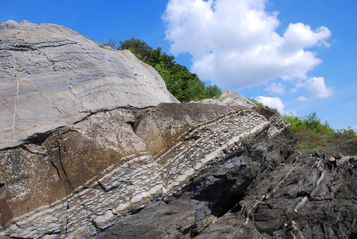
During this period, the Earth entered a long, warm greenhouse phase, and warm shallow seas covered much of the equatorial land masses. Early in the Silurian, glaciers retreated back into the South Pole until they almost disappeared in the middle of Silurian. The period witnessed a relative stabilization of the Earth’s general climate, ending the previous pattern of erratic climatic fluctuations. Layers of broken shells (called coquina) provide strong evidence of a climate dominated by violent storms generated then as now by warm sea surfaces. Later in the Silurian, the climate cooled slightly, but in the Silurian-Devonian boundary, the climate became warmer.
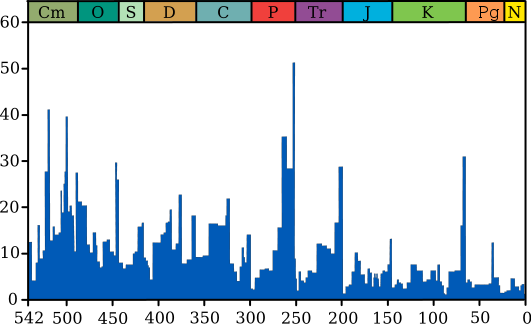
Perturbations
Flora and fauna
The Silurian was the first period to see macrofossils of extensive terrestrial biota, in the form of moss forests along lakes and streams. However, the land fauna did not have a major impact on the Earth until it diversified in the Devonian.
The first fossil records of vascular plants, that is, land plants with tissues that carry food, appeared in the second half of the Silurian period. The earliest known representatives of this group are Cooksonia (mostly from the northern hemisphere) and Baragwanathia (from Australia). Most of the sediments containing Cooksonia are marine in nature. Preferred habitats were likely along rivers and streams. Baragwanathia, appears to be almost as old dating to the Early Ludlow (420 million years) and has branching stems and needle-like leaves of 10-20 cm. The plant shows a high degree of development in relation to its age. As mentioned, fossils of this plant are only found in Australia.
The much-branched Psilophyton was a primitive Silurian land plant with xylem and phloem but no differentiation in root, stem or leaf. It reproduced by spores, had stomata on every surface, and probably photosynthesized in every tissue exposed to light. Rhyniophyta and primitive lycopods were other land plants that first appear during this period. Neither mosses nor the earliest vascular plants had deep roots. Silurian rocks often have a brownish tint, possibly a result of extensive erosion of the early soils.
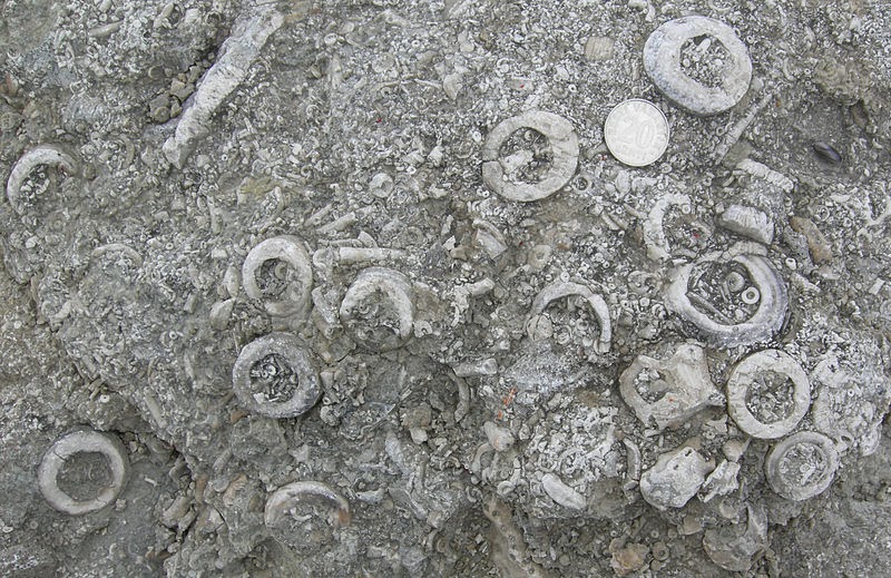
The first bony fish, the Osteichthyes, appeared, represented by the Acanthodians covered with bony scales; fish reached considerable diversity and developed movable jaws, adapted from the supports of the front two or three gill arches. A diverse fauna of Eurypterids (sea scorpions)—some of them several meters in length—prowled the shallow Silurian seas of North America; many of their fossils have been found in New York state. Leeches also made their appearance during the Silurian Period. Brachiopods, bryozoa, molluscs, hederelloids, tentaculitoids, crinoids and trilobites were abundant and diverse.
Reef abundance was patchy; sometimes fossils are frequent but at other points are virtually absent from the rock record.
The earliest known terrestrial animals appear during the Mid Silurian, including the millipede Pneumodesmus. Some evidence also suggests the presence of predatory trigonotarbid arachnoids and myriapods in Late Silurian facies. Predatory invertebrates would indicate that simple food webs were in place that included non-predatory prey animals. Extrapolating back from Early Devonian biota, Andrew Jeram et al. in 1990 suggested a food web based on as yet undiscovered detritivores and grazers on micro-organisms.


, to th)