Hawaii sits at the end of a chain of volcanoes running across the Pacific Ocean floor, but in the middle of this chain lies a bend of 60 degrees. For many decades geoscientists have struggled to explain exactly how and why this feature occurred around 50 Million years ago. A new study in Science Advances led by postdoctoral researcher Mathew Domeier along with colleagues from the Centre for Earth Evolution and Dynamics (CEED), University of Oslo, sheds light on this long-standing geological controversy – A massive collision at the edge of the Pacific Ocean was the culprit.
Mantle plumes and volcanic chains
There is more than meets the eye with the Hawaiian Islands of the Pacific Ocean. The islands presently sit above a so-called mantle plume, or a conduit of anomalously hot rock upwelling from thousands of kilometers deep in the Earth’s interior. This hot feature explains why the islands are dotted with active volcanoes. But the Hawaiian Islands also reside on the Pacific tectonic plate, which is moving across the top of the mantle plume—at the blistering pace of a few cm/year—which means that in a few million years the islands will have moved off the hot conduit and volcanism in the Hawaiian Islands will cease.
As Hawaii’s active volcanoes die in the future, new volcanic islands will appear elsewhere on the Pacific Plate, specifically at spots that replace the Hawaiian Islands above the hot conduit. This process is much like what would happen if you moved a sheet of paper over a stationary candle: the movement of the paper will be recorded as a trail of burn marks from the heat of the candle beneath. Hawaii is presently over the “candle,” but in the future it will have moved away from it and the candle will begin singing a new spot on the paper.
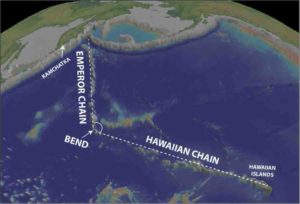
This process has happened over and over again in Earth’s long history, and Hawaii is just the latest volcanic chapter in a story that extends backward at least 80 million years. The Hawaiian Islands lie at the end of a chain of now-extinct volcanoes and seamounts (submerged volcanoes) that stretch ~6,000 km northwest across the floor of the Pacific Plate, to the junction between the western Aleutian Islands and the Peninsula of Kamchatka. Returning to our paper and candle analogy—this chain is the same as the path of singed marks leading backwards from the present location of the candle beneath the paper. In the Pacific, the volcanoes and seamounts that constitute this chain grow progressively older to the northwest, as would be expected if the chain marked the slow and progressive drift of the Pacific Plate above a mantle plume.
But something curious catches the eye about this submerged volcanic chain in the Pacific: it isn’t straight. A very conspicuous kink divides the chain into two segments: a mostly west-trending segment (the “Hawaiian Chain’) and a mostly north-trending segment (the “Emperor Chain’); the kink between is thus commonly referred to as the “Hawaiian-Emperor Bend.” Volcanic rocks sampled from seamounts on either side of the bend have been dated, and indicate that the bend developed approximately 47 million years ago.
So what caused it? This very question has been the source of debate and controversy among researchers for half a century. The classical explanation is that the bend marked a swift and substantial change in the direction of motion of the Pacific Plate about 50 million years ago, but supporters of this interpretation have struggled to explain why that sudden change occurred.
- The research team from University of Oslo carefully collected together a variety of evidence that suggests that the Pacific Plate changed its course about 50 million years ago because an archipelago that previously formed the northern end of the Pacific Plate crashed into eastern Asia at that time.
- The archipelago comprised what is known as an island arc: an elongate chain of volcanoes and volcanic rocks formed above a subduction zone (a zone where the seafloor of an oceanic tectonic plate is pushed under another tectonic plate and sinks into the mantle below). The team was able to work out the fiery history of the island arc and its relation to the Hawaiian-Emperor Bend from three key sources of data:
- Exotic rocks: The pieces of that island arc, which are now found on the peninsula of Kamchatka and in the Japanese Islands, are geologically exotic, meaning that they do not have the same characteristics of other rocks from the same region and were clearly transported from somewhere else—and they specifically reveal that they formed far away from any large continents (like Asia).
- Magnetic rocks: Magnetic information preserved in the island arc rocks (acquired from the Earth’s magnetic field when the rocks originally formed) can be used to determine the latitude at which they originated—and the magnetic information from the island arc rocks reveals that they came from further south than where they are located today (this also corroborates their exotic nature).
- Deep rocks: Island arcs only develop along a subduction zone, so the formation of the island arc should have been accompanied by subduction, and subduction, in turn, is associated with the sinking of oceanic tectonic plates into Earth’s interior. The relics of subducted oceanic plates can be “imaged” by seismic waves generated by earthquakes, in much the same way that your bones can be imaged with X-rays during a CT scan. By such seismic imaging techniques we have identified the relics of a subduction system that was formerly located at the northern end of the Pacific Plate, at the same place that the island arc rocks were located according to their magnetic data.
A crash caused the bend
Together, the geologic, magnetic and seismic clues from the North Pacific indicate that subduction and island arc construction began 80 million years ago at the northern end of the Pacific Plate. Immediately after subduction started, the subduction zone began moving north, pulling the island arc and the Pacific Plate north with it. This northward migration continued from 80 to 50 million years, at which time the Emperor Chain was formed by the northern drift of the Pacific over the mantle plume.
By about 50 million years ago, the northern migration of subduction led to a colossal collision between the island arc at the northern end of the Pacific Plate and the northeast edge of Asia. This massive crash left large segments of the former island arc stranded in northeast Japan and on the peninsula of Kamchatka, and terminated subduction there.
The crash and the cessation of subduction effectively halted the northward course of the Pacific Plate at that time, and it was this event that was responsible for suddenly re-routing the direction of the Pacific Plate 50 million years ago. So in the end, it was a continental-scale fender-bender that gave the Pacific its spectacular bend, according to the new study published in Science Advances.
Reference:
Mathew Domeier et al. Intraoceanic subduction spanned the Pacific in the Late Cretaceous–Paleocene, Science Advances (2017). DOI: 10.1126/sciadv.aao2303
Note: The above post is reprinted from materials provided by CEED.


