A long lasting foreshock series controlled the rupture process of this year’s great earthquake near Iquique in northern Chile. The earthquake was heralded by a three quarter year long foreshock series of ever increasing magnitudes culminating in a Mw 6.7 event two weeks before the mainshock. The mainshock (magnitude 8.1) finally broke on April 1st a central piece out of the most important seismic gap along the South American subduction zone. An international research team under leadership of the GFZ German Research Centre for Geosciences now revealed that the Iquique earthquake occurred in a region where the two colliding tectonic plates where only partly locked.
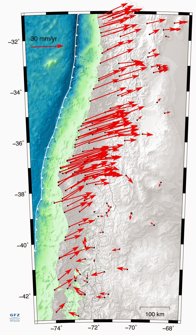
The Pacific Nazca plate and the South American plate are colliding along South America’s western coast. While the Pacific sea floor submerges in an oceanic trench under the South American coast the plates get stressed until occasionally relieved by earthquakes. In about 150 years time the entire plate margin from Patagonia in the south to Panama in the north breaks once completely through in great earthquakes. This cycle is almost complete with the exception of a last segment — the seismic gap near Iquique in northern Chile. The last great earthquake in this gap occurred back in 1877. On initiative of the GFZ this gap was monitored in an international cooperation (GFZ, Institut de Physique du Globe Paris, Centro Sismologico National — Universidad de Chile, Universidad de Catolica del Norte, Antofagasta, Chile) by the Integrated Plate Boundary Observatory Chile (IPOC), with among other instruments seismographs and cont. GPS. This long and continuous monitoring effort makes the Iquique earthquake the best recorded subduction megathrust earthquake globally. The fact that data of IPOC is distributed to the scientific community in near real time, allowed this timely analysis.
Ruptures in Detail
The mainshock of magnitude 8.1 broke the 150 km long central piece of the seismic gap, leaving, however, two large segments north and south intact. GFZ scientist Bernd Schurr headed the newly published study that appeared in the lastest issue of Nature Advance Online Publication: “The foreshocks skirted around the central rupture patch of the mainshock, forming several clusters that propagated from south to north.” The long-term earthquake catalogue derived from IPOC data revealed that stresses were increasing along the plate boundary in the years before the earthquake. Hence, the plate boundary started to gradually unlock through the foreshock series under increasing stresses, until it finally broke in the Iquique earthquake. Schurr further states: “If we use the from GPS data derived locking map to calculate the convergence deficit assuming the ~6.7 cm/yr convergence rate and subtract the earthquakes known since 1877, this still adds up to a possible M 8.9 earthquake.” This applies if the entire seismic gap would break at once. However, the region of the Iquique earthquake might now form a barrier that makes it more likely that the unbroken regions north and south break in separate, smaller earthquakes.
International Field Campaign
Despite the fact that the IPOC instruments delivered continuous data before, during and after the earthquake, the GFZ HART (Hazard And Risk Team) group went into the field to meet with international colleagues to conduct additional investigations. More than a dozen researchers continue to measure on site deformation and record aftershocks in the aftermath of this great rupture. Because the seismic gap is still not closed, IPOC gets further developed. So far 20 multi-parameter stations have been deployed. These consist of seismic broadband and strong-motion sensors, continuous GPS receivers, magneto-telluric and climate sensors, as well as creepmeters, which transmit data in near real-time to Potsdam. The European Southern astronomical Observatory has also been integrated into the observation network.
Note : The above story is based on materials provided by GFZ GeoForschungsZentrum Potsdam, Helmholtz Centre.


