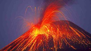
Researchers report in a new study that they’ve documented rumblings of volcanic thunder for the first time, a feat considered nearly impossible by many volcanologists.
Microphones set out to detect volcanic eruptions in Alaska’s Aleutian Islands recorded sounds of Bogoslof volcano erupting over eight months from December 2016 to August 2017. Researchers analyzing the recordings identified several cracking sounds from eruptions on March 8 and June 10 as volcanic thunder, a phenomenon the study authors said has never before been captured in audio recordings.
Observers have described hearing volcanic thunder in the past, but scientists have been unable to disentangle the booms of thunder caused by volcanic lightning from the cacophony of bellows and blasts that accompany an explosive eruption. In the new study, researchers used microphones on a nearby island and maps of volcanic lightning strokes to identify the sounds of thunder.
“It’s something that people who’ve been at eruptions have certainly seen and heard before, but this is the first time we’ve definitively caught it and identified it in scientific data,” said Matt Haney, a seismologist at the Alaska Volcano Observatory in Anchorage and lead author of the new study accepted for publication in Geophysical Research Letters, a journal of the American Geophysical Union.
Analyzing volcanic thunder offers scientists a new way of detecting volcanic lightning and potentially a way to estimate the size of an ash plume, according to Jeff Johnson, a geophysicist at Boise State University who was not connected to the new study.
Haney and his team found the intensity of the thunder matched the intensity of the lightning, meaning researchers might be able to use thunder as a proxy for volcanic lightning, Johnson said. The intensity of lightning in a volcanic plume can tell scientists how big the plume is and how hazardous it might be.
“Understanding where lightning is occurring in the plume tells us about how much ash has been erupted, and that’s something that’s notoriously difficult to measure,” Johnson said. “So if you’re locating thunder over a long area, you could potentially say something about how extensive the plume is.”
Monitoring impending eruptions
Volcanic eruptions are inherently noisy – explosions of smoke, ash and magma shake the ground and create loud bangs and rumbles that reverberate for miles. Lightning is common in volcanic plumes because particles of ash and ice scrape and collide with each other and become electrified. Researchers assumed volcanic lightning is followed by thunder, as it is during thunderstorms, but they had not yet been able to tease out thunderclaps from the noises of the eruption itself, and many scientists considered it impossible, according to Haney.
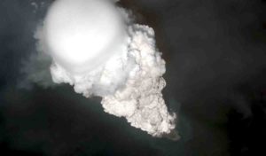
In the new study, scientists detected thunder at Bogoslof volcano in Alaska’s Aleutian Islands, a chain of more than 50 volcanic islands in the northern Pacific Ocean.
Researchers constantly monitor the islands from afar for signs of impending eruptions. They use seismic sensors to pick up ground movement before or during an eruption, arrays of microphones to detect sounds of ash exploding skyward and a global network of lightning sensors to detect lightning strokes within an ash plume. Thunderstorms are rare in the Aleutian Islands, so when sensors detect lightning, it most likely means there’s an ongoing eruption, Haney said.
Bogoslof started erupting in December 2016 and erupted more than 60 times through August 2017. Many of the eruptions produced towering clouds of ash more than six kilometers (20,000 feet) high that disrupted air travel throughout the region.
Isolating thunderclaps
Bogoslof’s eruptions on March 8 and June 10 created ideal conditions for observing volcanic thunder, Haney said. Both eruptions generated immense ash plumes that persisted for several hours after the eruptions ceased. Without the din of an eruption in the background, researchers had a better chance of hearing cracks of thunder caused by lightning in the plume.
Worldwide lightning sensors detected lightning strokes in the ash plumes for several minutes after each eruption ended. In the new study, Haney and his colleagues compared the timing and location of the lightning strokes to sounds recorded by a microphone array on a nearby island.
They found the timing and volume of the sounds the microphones picked up matched the lightning data in a way only thunder could.
On March 8, the microphones recorded at least six distinct bursts of sound that occurred three minutes after lightning activity in the plume peaked. The timing of the bursts means they were almost certainly thunderclaps caused by the lightning: The microphones were 60 kilometers (40 miles) away from the volcano, so it would have taken sound three minutes to reach the microphones. That the thunder was picked up so far away also means it was quite loud, Haney said.
On June 10, the microphones picked up bursts of sound coming from a slightly different direction than sounds from the eruption. The location of the bursts corresponded to areas of peak lightning activity, according to the study.
“If people had been observing the eruption in person, they would have heard this thunder,” Haney said. “I expect that going forward, other researchers are going to be excited and motivated to look in their datasets to see if they can pick up the thunder signal.”
Reference:
Volcanic thunder from explosive eruptions at Bogoslof volcano, Alaska. Geophysical Research Letters. DOI: 10.1002/2017GL076911
Note: The above post is reprinted from materials provided by American Geophysical Union.