Ocean. Some 520-540 million years ago, animal life evolved in the ocean and began breaking down organic material on the seafloor, leading to more carbon dioxide and less oxygen in the atmosphere. Credit: Copyright Michele Hogan
The evolution of Earth’s first animals more than 500 million years ago caused global warming, new research shows.
Some 520-540 million years ago, animal life evolved in the ocean and began breaking down organic material on the seafloor, leading to more carbon dioxide and less oxygen in the atmosphere.
In the 100 million years that followed, conditions for these earliest animals became much harsher, as ocean oxygen levels fell and carbon dioxide caused global warming.
The research, published in Nature Communications, is from the Universities of Exeter, Leeds and Antwerp, and the Vrije Universiteit Brussel.
“Like worms in a garden, tiny creatures on the seabed disturb, mix and recycle dead organic material — a process known as bioturbation,” said Professor Tim Lenton, from the University of Exeter.
“Because the effect of animals burrowing is so big, you would expect to see big changes in the environment when the whole ocean floor changes from an undisturbed state to a bioturbated state.”
“We did indeed see a decrease in oxygen levels in the ocean around 520 million years ago,” said Professor Filip Meysman, from the University of Antwerp.
“But evidence from the rock record showed sediment was only a little disturbed.”
Professor Simon Poulton, from the University of Leeds, said: “This meant that the animals living in the seafloor at that time were not very active, and did not move very deep into the seabed.
“At first sight, these two observations did not seem to add up.”
Lead author Dr Sebastiaan van de Velde, of the Vrije Universiteit Brussel, explained: “The critical factor was to realise that the biggest changes happen at the lowest levels of animal activity.
“This meant that the first bioturbators had a massive impact.”
The researchers said this realisation was the “missing piece of the puzzle,” and allowed them to construct a mathematical model of Earth around that time to look to the changes caused by these early life forms.
Dr Benjamin Mills, also from the University of Leeds, who led this part of the research, said: “When we ran our model, we were surprised by what we saw.
“The evolution of these small animals did indeed decrease the oxygen in the ocean and atmosphere, but also increased atmospheric carbon dioxide levels to such an extent that it caused a global warming event.
“We knew that warming occurred at this point in Earth history, but did not realise it could be driven by animals.”
This process made conditions worse for these animals, which possibly contributed to a number of mass extinction events during the first 100 million years of animal evolution.
“There is an interesting parallel between the earliest animals changing their world in a way that was bad for them, and what we human animals are doing to the planet now,” said Professor Lenton, director of Exeter’s new Global Systems Institute, which aims to develop transformative solutions to the challenges facing the world today.
“We are creating a hotter world with expanding ocean anoxia (oxygen deficiency) which is bad for us and a lot of other creatures we share the planet with.”
Reference:
Sebastiaan van de Velde, Benjamin J. W. Mills, Filip J. R. Meysman, Timothy M. Lenton, Simon W. Poulton. Early Palaeozoic ocean anoxia and global warming driven by the evolution of shallow burrowing. Nature Communications, 2018; 9 (1) DOI: 10.1038/s41467-018-04973-4
Note: The above post is reprinted from materials provided by University of Exeter.
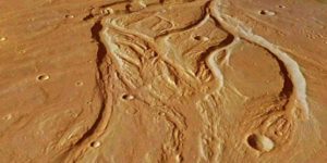
The central portion of Osuga Valles, which has a total length of 164 km. In some places, it is 20 km wide and plunges to a depth of 900 m. Credit: ESA/DLR/FU Berlin, CC BY-SA 3.0 IGO
The surface of Mars bears imprints of structures that resemble fluvial steam networks on Earth. Scientists therefore assume that there must have been once enough water on the red planet to feed water streams that incised their path into the soil. For years, however, scientists have been debating the source from which this water must have originated: was it rainwater that caused streams and rivers to swell? Or did water ice in the soil melt due to volcanic activity, and seep out to form rivers? Each of these scenarios leads to a completely different conclusion about the climatic history of the red planet.
A new study now suggests that the branching structure of the former river networks on Mars has striking similarities with terrestrial arid landscapes. This has been demonstrated in a recent paper published in Science Advances by physicist Hansjörg Seybold from the group of James Kirchner, ETH professor at the Institute for Terrestrial Ecosystems, and planetary specialist Edwin Kite from the University of Chicago.
Valleys eroded mainly by rainwater
Using statistics from all mapped river valleys on Mars, the researchers conclude that the contours still visible today must have been created by superficial run-off of (rain)water. Consequently, the influence of groundwater seepage from the soil can be excluded as a dominant process for shaping these features.
The distribution of the branching angles of the valleys on Mars is very similar to those found in arid landscapes on Earth. According to lead author Seybold, this implies that there must have been a similar hydrological environment with sporadic heavy rainfall events on Mars over a prolonged period of time and that this rainwater may have run off quickly over the surface shaping the valley networks. This is how river valleys develop in arid regions on Earth. For example, in Arizona, researchers observed the same valley network patterns in a landscape where astronauts are training for future Mars missions. Valleys in arid regions fork at a narrow angle.
The branching angles on Mars are comparatively low. Seybold therefore rules out the influence of groundwater sapping as the major channel forming process on Mars. River networks that are formed by re-emerging groundwater, as found, for example, in Florida, tend to have much wider branching angles between the two tributaries and do not match the narrow angles of streams in arid areas.
Conditions such as those found in terrestrial arid landscapes today probably prevailed on Mars for only a relatively short period about 3.6 to 3.8 billion years ago. In that period, the atmosphere on Mars may have been much denser than it is today. “Recent research shows that there must have been much more water on Mars than previously assumed,” says Seybold.
Evaporation made it rain
One hypothesis suggests that the northern third of Mars was covered by an ocean at that time. Water evaporated, condensed around the high volcanoes of the highlands to the south of the ocean and led to heavy precipitation. As a result, rivers formed, which left traces that can still be observed on Mars today.
The big question is where the water has disappeared to over time. “It’s likely that most of it evaporated into space. But it could still be found in the vicinity of Mars,” says the physicist., ” but this is a question for a future space mission.”
Reference:
Hansjoerg J. Seybold, Edwin Kite, James W. Kirchner. Branching geometry of valley networks on Mars and Earth and its implications for early Martian climate. Science Advances, 2018; 4 (6): eaar6692 DOI: 10.1126/sciadv.aar6692
Note: The above post is reprinted from materials provided by ETH Zurich. Original written by Peter Rüegg.
These are Ediacaran fossils at Mistaken Point, Newfoundland. Credit: Emily Mitchell
Some of the earliest complex organisms on Earth — possibly some of the earliest animals to exist — got big not to compete for food, but to spread their offspring as far as possible.
The research, led by the University of Cambridge, found that the most successful organisms living in the oceans more than half a billion years ago were the ones that were able to ‘throw’ their offspring the farthest, thereby colonising their surroundings. The results are reported in the journal Nature Ecology and Evolution.
Prior to the Ediacaran period, between 635 and 541 million years ago, life forms were microscopic in size, but during the Ediacaran, large, complex organisms first appeared, some of which — such as a type of organism known as rangeomorphs — grew as tall as two metres. These organisms were some of the first complex organisms on Earth, and although they look like ferns, they may have been some of the first animals to exist — although it’s difficult for scientists to be entirely sure. Ediacaran organisms do not appear to have mouths, organs or means of moving, so they are thought to have absorbed nutrients from the water around them.
As Ediacaran organisms got taller, their body shapes diversified, and some developed stem-like structures to support their height.
In modern environments, such as forests, there is intense competition between organisms for resources such as light, so taller trees and plants have an obvious advantage over their shorter neighbours. “We wanted to know whether there were similar drivers for organisms during the Ediacaran period,” said Dr Emily Mitchell of Cambridge’s Department of Earth Sciences, the paper’s lead author. “Did life on Earth get big as a result of competition?”
Mitchell and her co-author Dr Charlotte Kenchington from Memorial University of Newfoundland in Canada examined fossils from Mistaken Point in south-eastern Newfoundland, one of the richest sites of Ediacaran fossils in the world.
Earlier research hypothesised that increased size was driven by the competition for nutrients at different water depths. However, the current work shows that the Ediacaran oceans were more like an all-you-can-eat buffet.
“The oceans at the time were very rich in nutrients, so there wasn’t much competition for resources, and predators did not yet exist,” said Mitchell, who is a Henslow Research Fellow at Murray Edwards College. “So there must have been another reason why life forms got so big during this period.”
Since Ediacaran organisms were not mobile and were preserved where they lived, it’s possible to analyse whole populations from the fossil record. Using spatial analysis techniques, Mitchell and Kenchington found that there was no correlation between height and competition for food. Different types of organisms did not occupy different parts of the water column to avoid competing for resources — a process known as tiering.
“If they were competing for food, then we would expect to find that the organisms with stems were highly tiered,” said Kenchington. “But we found the opposite: the organisms without stems were actually more tiered than those with stems, so the stems probably served another function.”
According to the researchers, one likely function of stems would be to enable the greater dispersion of offspring, which rangeomorphs produced by expelling small propagules. The tallest organisms were surrounded by the largest clusters of offspring, suggesting that the benefit of height was not more food, but a greater chance of colonising an area.
“While taller organisms would have been in faster-flowing water, the lack of tiering within these communities shows that their height didn’t give them any distinct advantages in terms of nutrient uptake,” said Mitchell. “Instead, reproduction appears to have been the main reason that life on Earth got big when it did.”
Despite their success, rangeomorphs and other Ediacaran organisms disappeared at the beginning of the Cambrian period about 540 million years ago, a period of rapid evolutionary development when most major animal groups first appear in the fossil record.
Reference:
Emily G. Mitchell, Charlotte G. Kenchington. The utility of height for the Ediacaran organisms of Mistaken Point. Nature Ecology & Evolution, 2018; DOI: 10.1038/s41559-018-0591-6
Note: The above post is reprinted from materials provided by University of Cambridge. The original story is licensed under a Creative Commons License.
The oldest known zircon from Mars. Credit: Martin Bizzarro
The early surface of Mars consisting of a liquid magma ocean crystallized extremely rapidly, just 20 million year after the formation of the solar system. Thereafter, a solid crust emerged on the red planet potentially housing oceans with water and life. This was about 130 million years before a corresponding solid crust appeared on Earth. New evidence for this rapid crystallization and crust formation on Mars has just been published in a study from the Centre for Star and Planet Formation at the Natural History Museum of Denmark, University of Copenhagen. The study, based on the analysis of the rare Mars meteorite Black Beauty, significantly expands the window for when life might have existed on Mars.
Crust formation is an important step in the development of terrestrial planets, and what makes Black Beauty special and expensive is that it contains small pieces of the crust from Mars. More precisely, Black Beauty contains the rare mineral zircon, in which researchers have found a high concentration of hafnium.
“Zircon is a very robust mineral that is ideally suited to provide absolute ages. In this context, the zircons can be used to establish a temporal framework to understand the formation history of the Martian crust,” says Professor Martin Bizzarro. “Zircon also acts as a small time capsule as it preserves information about the environment where and when it was created. In this case, a time capsule with hafnium that originates from the earliest crust of Mars, which was present approximately 100 million years before the oldest zircon of Black Beauty was created. Thus, Mars got an early start compared to Earth, whose solid crust wasn’t formed until much later.”
However, it required a certain amount of courage to reach this result.
We crushed the meteorite
The original 319.8 grams heavy meteorite Black Beauty was found in the Sahara Desert in 2011. It soon became apparent that the meteorite was something special and it currently has a sales price of approximately $10,000 per gram. A year ago, Professor Martin Bizzarro managed to acquire 44 grams of Black Beauty with help from various funding agencies and exchange of meteorites from the museum’s collection.
“One of the big challenges has been that the zircons in Black Beauty are extremely small. This called for a courageous strategy: We crushed our precious meteorite. Or to be precise: We crushed 5 grams,” says Martin Bizzarro. “Today, I’m glad we chose that strategy. It released seven zircons, one of which is the oldest known zircon from Mars. And from the zircons and their content of hafnium, we can now conclude that the crystallization of the surface of Mars went extremely fast: already 20 million years after the formation of the solar system, Mars had a solid crust that could potentially could house oceans and perhaps also life.”
Reference:
Laura C. Bouvier, Maria M. Costa, James N. Connelly, Ninna K. Jensen, Daniel Wielandt, Michael Storey, Alexander A. Nemchin, Martin J. Whitehouse, Joshua F. Snape, Jeremy J. Bellucci, Frédéric Moynier, Arnaud Agranier, Bleuenn Gueguen, Maria Schönbächler, Martin Bizzarro. Evidence for extremely rapid magma ocean crystallization and crust formation on Mars. Nature, 2018; 558 (7711): 586 DOI: 10.1038/s41586-018-0222-z
Terminal Ediacaran carbonate rocks in Three Gorges area (Hubei Province), People’s Republic of China. These rocks were deposited in a shallow marine environment between 551 million and 541 million years ago and hold a record of the marine environmental changes that occurred at the time they were deposited. Credit: ASU
Fossil records tell us that the first macroscopic animals appeared on Earth about 575 million years ago. Twenty-four million years later, the diversity of animals began to mysteriously decline, leading to Earth’s first know mass extinction event.
Scientists have argued for decades over what may have caused this mass extinction, during what is called the “Ediacaran-Cambrian transition.” Some think that a steep decline in dissolved oxygen in the ocean was responsible. Others hypothesize that these early animals were progressively replaced by newly evolved animals.
The precise cause has remained elusive, in part because so little is known about the chemistry of Earth’s oceans that long ago.
A research team, led by scientists from Arizona State University and funded by NASA and the National Science Foundation, is helping to unravel this mystery and understand why this extinction event happened, what it can tell us about our origins, and how the world as we know it came to be. The study, published in Science Advances, was led by ASU School of Earth and Space Exploration graduate student Feifei Zhang, under the direction of faculty member Ariel Anbar and staff scientist Stephen Romaniello.
The importance of oxygen
Today there is an abundance of oxygen, a vital component of life, throughout most of the Earth’s oceans. But there is evidence to suggest that during the mass extinction event, there was a loss of dissolved oxygen in Earth’s oceans, an effect called “marine anoxia.”
To get a better understanding of the mass extinction event, the research team focused on studying this effect. They wanted to determine not only how much of the ocean was anoxic when the animals began to decline, but also whether marine anoxia contributed to the decline and eventual extinction of the early animals.
Integrating geochemical data and the Earth’s fossil records
To determine the levels of marine anoxia and its effects, the research team used a novel approach of combining geochemical data and the Earth’s fossil record to precisely match evolutionary and environmental events.
Typically, scientists determine ocean anoxia levels by looking at the abundance of pyrite, commonly known as “fool’s gold,” and other elements and minerals in ancient mud rocks. But mud rocks only provide clues to what may have happened at a single location. Scientists need to sample dozens of sites around the world to infer the big picture from mud rocks.
To overcome this, the team pioneered a new and more efficient approach. Rock samples of marine limestone were collected in the Three Gorges Area (Hubei Province) of the People’s Republic of China. This area is known for having some of the best examples in the world from the Ediacaran Period. The rock samples for this study were deposited in a shallow marine environmental between 551 and 541 million years ago, and hold a record of the marine environmental changes that occurred when they were deposited.
Back at the lab, the team measured the uranium isotope variations in marine limestone and then then integrated the uranium isotope data and paleontological data from the same suite of rocks. Once the data were integrated, the team could clearly see that the episode of extensive marine anoxia coincided with the decline and the subsequent disappearance of early animals.
“This may have been most severe marine anoxic event in the last 550 million years,” says Zhang. “Mathematical modeling of our data suggests that almost the entire seafloor was overlain by anoxic waters during the end of the Ediacaran Period.”
Is there a mass extinction in our future?
While our oceans currently have an abundance of oxygen, there has been a recent measurable rise in ocean anoxia, attributed by scientists to climate change. Advances in the study of ancient marine anoxia, like this one, then may help us understand and predict what lies ahead.
“The past is our best laboratory to understand the future” says co-author Anbar “It’s sobering to see how often the mass extinctions of the past were preceded by increases in ocean anoxia. There is a lot we don’t understand about climate change, but the things we do know are a big cause for concern.”
Reference:
Feifei Zhang, Shuhai Xiao, Brian Kendall, Stephen J. Romaniello, Huan Cui, Mike Meyer, Geoffrey J. Gilleaudeau, Alan J. Kaufman, Ariel D. Anbar. Extensive marine anoxia during the terminal Ediacaran Period. Science Advances, 2018; 4 (6): eaan8983 DOI: 10.1126/sciadv.aan8983
Quartz analysis. Credit: Courtesy of Michael Ackerson
A team of scientists including Carnegie’s Michael Ackerson and Bjorn Mysen revealed that granites from Yosemite National Park contain minerals that crystallized at much lower temperatures than previously thought possible. This finding upends scientific understanding of how granites form and what they can teach us about our planet’s geologic history. Their work is published in Nature.
Granites are igneous rocks comprised predominately of the minerals quartz and feldspar. They are the link between igneous processes that occur within the Earth and volcanic rocks that solidified on Earth’s surface.
“Granites are the ultimate product of the processes by which our planet separated into layers and they are key to understanding the formation of the continental crust,” Ackerson said. “Minerals from granites record almost all of our planet’s history — from 4.4 billion years ago to today.”
So, understanding the conditions under which granites form is important to geoscientists trying to unravel the processes that have shaped the Earth.
Until now, the prevailing wisdom on granites was that the minerals that comprise them crystallize as the molten rock cools to temperatures between 650 and 700 degrees Celsius (or between about 1,200 and 1,300 degrees Fahrenheit). Below these temperatures, the granites have been assumed to be completely crystallized.
It was previously known that under certain conditions some of the minerals of which granite is comprised can solidify at lower temperatures. So, the team — which also included Nicholas Tailby of the American Museum of Natural History and Bruce Watson of the Rensselaer Polytechnic Institute — used lab analysis to determine the temperatures of granite crystallization in granites from Yosemite National Park.
The team employed a technique called titanium in quartz thermometry. By measuring the amount of titanium dissolved in the quartz crystals, the team was able to determine the temperatures at which it crystallized deep in the Earth when the granites formed 90 million years ago.
They demonstrated that quartz crystals in samples of a body of granite body called the Tuolumne Intrusive Suite in Yosemite crystallized at temperatures between 474 and 561 Celsius (or 885 and 1,042 degrees Fahrenheit) — up to 200 degrees cooler than previously thought possible for granites.
“These granites tell a different story,” Ackerson added. “And it could rewrite what we think we understand about how Earth’s continents form.”
These findings could influence our understanding of the conditions in which the Earth’s crust first formed during the Hadean and Archean. They could also explain some recent observations about the temperature at which volcanic magmas exist before eruption and the mechanisms through which economically important ore deposits form.
This work was supported by the NASA Astrobiology Institute.
Reference:
Michael R. Ackerson, B. O. Mysen, N. D. Tailby, E. B. Watson. Low-temperature crystallization of granites and the implications for crustal magmatism. Nature, 2018; DOI: 10.1038/s41586-018-0264-2
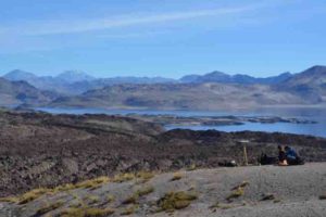
In a scene dominated by volcanism and erosion, Hélène Le Mével (left) and a colleague set up a precision GPS station to measure altitude of a portion of the ancient shoreline of Laguna del Maule, Chile. Credit: Brad Singer
The Laguna del Maule volcanic complex in Chile is a large, complicated and explosive landscape that, oddly, lacks the classic cone seen on many volcanoes, including Fuego, the Guatemalan volcano that killed hundreds in a June 3 eruption.
It’s a major task to understand a mountaintop region that has erupted 50 times over the past 20,000 years. But the starting point for grasping the big picture of a study published today (June 27) in Science Advances is pretty simple: It’s the ring that standing water leaves on a bathtub.
Like the shore of an ancient lake, a bathtub ring must be horizontal when it forms. But, as University of Wisconsin-Madison professor of geoscience Brad Singer noticed years ago, the ancient, elevated shoreline at Maule now slopes from a low spot in the north to a high spot in the south.
The Maule volcanoes, located in a region that has seen enormous eruptions during the last million years, are restless. Since 2007, satellite instruments have measured an average uplift of 8 inches per year — far and away the fastest and longest measured rise of a restless volcano in the world, and an unmistakable sign that molten rock under the area is rising.
Singer, a volcanologist and specialist in dating rocks, currently directs a five-year National Science Foundation project to explore Maule with a wide variety of geologic techniques. Understanding why that rise is taking place, and what it portends, are two central goals of the project, which brought dozens of scientists and students to the site.
Generally, volcanology is a rearview-mirror exercise. Months, years, or even 50 million years after the lava cools and the ash settles, scientists examine the chemistry, shape, and distribution of rocks in a forensic effort to understand a volcanic site. At Laguna del Maule, among the most active volcanic regions in the world, Singer is trying to document conditions and processes before the next eruption.
Chile has more than 80 volcanoes. Maule, along with many others, erupts rhyolite, a particularly explosive kind of molten rock. Rhyolite contains a high level of water and carbon dioxide, which both flash to gas as pressure drops when the magma approaches earth’s surface.
Knowing the rate and variations of magma rising into a reservoir beneath a volcano is critical to questions about future eruptions, but measurements of rock properties up to a dozen miles underground must, by definition, be indirect.
The goal, Singer says, “Is to build a mental picture, a model, for the mechanisms that operate before a large, or ‘super’ eruption.”
The study in Science Advances used the ancient shoreline for baseline information about the area’s landscape 10,000 years ago. That was when a rhyolite lava flow that “plugged” the lake’s outlet collapsed, dropping the water level by about 200 meters down to its present level.
The relic shoreline was at least 60 kilometers long, although much of it has since been covered by lava flows. During four field trips, Singer and colleagues used precise GPS instruments to get altitude measurements at 64 points along the shoreline.
The highest point, they found, was 62 meters above the lowest point, allowing the researchers to calculate an average rise of 6 millimeters per year. But if the current rapid uplift following a period of stability is typical, the total uplift likely occurred in as many as 16 rapid pulses, averaging 50 years each, during the past 10,000 or so years.
The baseline information on uplift was then combined with data on earth shaking, gravity and electrical conductivity, and analyses of minerals at the surface — the relics of past eruptions — to paint a better picture of the geologic situation.
Hélène Le Mével, a UW-Madison geoscience Ph.D. and paper co-author, used the warping of the shoreline to estimate the shape, size and depth of the magma body that grew beneath the southern end of the lake. The body is 7 kilometers deep and has a shape something like an egg.
Since the natural lava dam burst and the lake level fell, the researchers calculated that 13 cubic kilometers of magma rose into this reservoir to create the magma body that raised the overlying volcanic region.
In the same period, another nine cubic kilometers of magma has erupted.
A clarified view of the pace and details of the uplift helped Singer’s team address two pressing issues in volcanology:
What role do fluids play in causing uplift at the biggest, most dangerous volcanoes? Volcanic uplift can be caused by rising magma, or by pressurized liquid or gas. If the researchers are correct that periods of uplift alternated with periods of stability over 9,400 years, then the magma must have been cooling into solid rock. Otherwise, each eruption would have allowed fluid and gas to escape, causing deflation.
What determines whether the magma reservoir erupts or freezes into a giant, homogenous rock body like Half Dome (called a pluton)? Can both phenomena occur in the same pool of magma at the essentially the same time? “Here, we have evidence that the same magma reservoir can sustain both processes,” says Singer. “The magma reservoir is slowly growing for thousands of years, at a shallow depth, and some of it is freezing, but during the same period, it’s also erupting.”
As for Maule itself, the rate of rise seems to be slowing after 11 race-car years. That likely reduces the probability of an eruption in the near term, which is good news to Chileans, and to Argentines, who live downwind from this border-straddling complex. Maule’s alert status is currently low on the list of more than 40 hazardous volcanoes that Chile’s Southern Andes Volcano Observatory monitors.
But that’s not the end of the story, says Singer. Even if the magma intrusions at Maule slowly grind to a halt, other factors could trigger an eruption.
Chile, part of the Ring of Fire, was site of two of the four most intense earthquakes in the past century. Moreover, even as uplift declines, an earthquake along a small local fault could promote enough movement of magma to trigger another eruption at Maule, Singer says.
This research was supported by U.S. NSF grants EAR-1411779 and EAR-1322595, OVDAS/SERNAGEOMIN, and the USGS Volcano Disaster Assistance Program.
Reference:
Brad S. Singer, Hélène Le Mével, Joseph M. Licciardi, Loreto Córdova, Basil Tikoff, Nicolas Garibaldi, Nathan L. Andersen, Angela K. Diefenbach, Kurt L. Feigl. Geomorphic expression of rapid Holocene silicic magma reservoir growth beneath Laguna del Maule, Chile. Science Advances, 2018; 4 (6): eaat1513 DOI: 10.1126/sciadv.aat1513
Jessica Irving sits with two meteorites Princeton seismologist Jessica Irving, an assistant professor of geosciences, sits with two meteorites from Princeton University’s collection that contain iron thought to be from the cores of planetesimals. We have no samples of Earth’s own core to study, so Irving uses seismology to investigate the deepest regions of the planet, recently developing a new model for the Earth’s outer core. Credit: Denise Applewhite, Office of Communications
By applying new data and Princeton’s supercomputers to the classic question of what lies beneath our feet, Princeton seismologist Jessica Irving and an international team of colleagues have developed a new model for the Earth’s outer core, a liquid iron region deep in the Earth.
The outer core is churning constantly, sustaining the planet’s magnetic field and providing heat to the mantle. “Understanding the outer core is crucial for understanding the history of the magnetic field,” said Irving, an assistant professor of geosciences. Her team’s work appears today in the journal Science Advances.
“The model we have produced, EPOC — Elastic Parameters of the Outer Core — is going to be the background model, the one thing that underlies everything else,” said Irving. The researchers describe EPOC as an outer core update of the existing Preliminary Earth Reference Model (PREM), a model of how fundamental Earth properties vary with depth, which was developed almost 40 years ago.
The key data in the research came from “normal modes,” which are standing waves that can be measured after the very largest earthquakes, typically magnitude 7.5 or higher. Unlike the body waves and surface waves that most seismologists study, normal modes are “the vibration of the whole Earth at once, which is kind of an amazing thing to think about,” Irving said. “We could say that the Earth ‘rings like a bell,’ at characteristic frequencies.”
The new model, EPOC, was first envisioned at a four-week summer science workshop where Irving was housed with fellow seismologists Sanne Cottaar, at the University of Cambridge, and Vedran Leki?, at the University of Maryland-College Park.
“PREM is a venerable, very simple, well-regarded model, but it can’t represent any small-scale structures,” Irving said. “We thought, ‘Can we make a simple model, with even fewer parameters than PREM, that does the job just as well?’ It turned out we could make a model that does the job much better.”
For one, EPOC reduces the need for a “complicated little layer” at the boundary between the core and the mantle, she said. Researchers in recent decades had found discrepancies between the PREM-predicted body wave velocity and the data they were finding, especially at the top of the core, and some had argued that there must be an anomalously slow layer hidden there. They debated how thick it should be — estimates range from 50 to 300 miles — and exactly what it must be composed of.
Her team’s model doesn’t offer any more specifics than PREM, Irving said, “but we suggest that because EPOC fits the data better, maybe you don’t need this little layer.” And additionally, it provides information about the material properties of the outer core.
The outer core is vitally important to the thermal history of the planet and its magnetic field, said Irving, but “it’s not tangible. We can’t show you a rock from the outer core. But at the same time, it is such a huge section of our planet. The core has roughly 30 percent of the mass of the planet in it. The crust is insignificant by comparison. There is so much that we don’t understand about the deep earth — and these aren’t even the complicated properties. We’re just looking for the very slowly varying bulk properties.”
To create their model, Irving and fellow seismologists pooled their skills. Cottaar had experience with equations of state — the physics explaining the connections between temperature, pressure, volume and other fundamental characteristics — and Leki? was fluent in Bayesian techniques, a probabilistic approach that helped the team sift through countless possible models and find the most likely ones. And because of her background with normal mode seismology, Irving knew how to work with the newly updated dataset.
“So all three of us were seismologists with different specialized skill sets, and we liked to have coffee at breakfast together,” Irving said. “It’s so much fun doing science with friends.”
The researchers fed the equations of state into Princeton’s Tiger supercomputer cluster to generate millions of possible models of the outer core. “Every six seconds we created a new model,” Irving said. “Some we rejected because they looked wrong. We have scientific tests for ‘wrong,’ for models that say things like, ‘The mass of the Earth should be twice what we think it is.'”
The team then took the best of the models and used them to predict what frequencies the whole Earth would shake at after a massive earthquake. The researchers compared the measured frequencies of normal modes to the predictions from their models until they found their preferred model.
When teaching about normal modes, Irving uses the metaphor of two bells, one of brass and one of steel, both painted white. “If you hit those bells, you’ll get different notes out of them, and that will tell you that you have different materials in there,” she said. “The exact frequencies — the exact pitch that the Earth at shakes after these very large earthquakes — depends on the material properties of the Earth. Just like we can’t see through the paint on the bells, we can’t see through the planet, but we can listen for the pitch, the frequencies of these whole-Earth observations, and use them to make inferences about what’s going on deep in the Earth.”
Reference:
Jessica C. E. Irving, Sanne Cottaar, Vedran Lekić. Seismically determined elastic parameters for Earth’s outer core. Science Advances, 2018; 4 (6): eaar2538 DOI: 10.1126/sciadv.aar2538
Note: The above post is reprinted from materials provided by Princeton University. Original written by Liz Fuller-Wright.
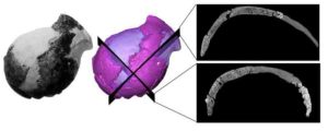
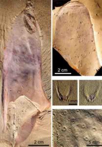
Original picture (left) and virtual rendering of the Jacovec cranium (middle) with two sections revealing the inner structure (right). Credit: Amelie Beaudet
A cranium of a four-million-year-old fossil, that, in 1995 was described as the oldest evidence of human evolution in South Africa, has shown similarities to that of our own, when scanned through high resolution imaging systems.
The cranium of the extinct Australopithecus genus was found in the lower-lying deposits of the Jacovec Cavern in the Sterkfontein Caves, about 40km North-West of Johannesburg in South Africa. Dr Amelie Beaudet from the School of Geography, Archaeology and Environmental Studies of the University of the Witwatersrand and her colleagues from the Sterkfontein team scanned the cranium at the Evolutionary Studies Institute, based at the University of the Witwatersrand, in 2016 and applied advanced imaging techniques in “virtual paleontology” to further explore the anatomy of the cranium. Their research was funded by the Centre of Excellence in Palaeosciences, the Claude Leon Foundation and the French Institute of South Africa and was published in the Journal of Human Evolution.
“The Jacovec cranium represents a unique opportunity to learn more about the biology and diversity of our ancestors and their relatives and, ultimately, about their evolution,” says Beaudet. “Unfortunately, the cranium is highly fragmentary and not much could be said about the identity nor the anatomy of the Jacovec specimen before.”
Through high resolution scanning, the researchers were able to quantitatively and non-invasively explore fine details of the inner anatomy of the Jacovec specimen and to report previously unknown information about the genus Australopithecus.
“Our study revealed that the cranium of the Jacovec specimen and of the Ausralopithecus specimens from Sterkfontein in general was thick and essentially composed of spongy bone,” says Beaudet. “This large portion of spongy bone, also found in our own cranium, may indicate that blood flow in the brain of Australopithecus may have been comparable to us, and/or that the braincase had an important role in the protection of the evolving brain.”
In comparing this cranium to that of another extinct group of our family tree, Paranthropus, that lived in South Africa along with the first humans less than two-million-years ago, their study revealed an intriguing and unexpected aspect of the cranial anatomy in this genus.
“We also found that the Paranthropus cranium was relatively thin and essentially composed of compact bone. This result is of particular interest, as it may suggest a different biology,” says Beaudet.
Situated in the Cradle of humankind, a Unesco World Heritage Site, the South African paleontological sites have played a pivotal role in the exploration of our origins. In particular, the Sterkfontein Caves site has been one of the most prolific fossil localities in Africa, with over 800 hominin remains representing 3 genera of hominin recovered since 1936, including the first adult Australopithecus, the iconic “Mrs Ples” and “Little Foot,” the most complete single skeleton of an early hominin yet found.
“The Jacovec cranium exemplifies the relevance of the Sterkfontein fossil specimens for our understanding of human evolution,” says Beaudet. “Imaging techniques open unique perspectives for revisiting the South African fossil assemblage.”
Reference:
Amélie Beaudet, Kristian J. Carlson, Ronald J. Clarke, Frikkie de Beer, Jelle Dhaene, Jason L. Heaton, Travis R. Pickering, Dominic Stratford. Cranial vault thickness variation and inner structural organization in the StW 578 hominin cranium from Jacovec Cavern, South Africa. Journal of Human Evolution, 2018; DOI: 10.1016/j.jhevol.2018.04.004
The researchers sampled the teeth of an extinct giant ground sloth similar to Lestodon, shown here, on display in the American Museum of Natural History. Credit: Copyright AMNH/D. Finnin
Knowing what extinct animals ate has long been determined by analyzing carbon isotopes locked inside fossil teeth. For two decades, a key isotope value in these equations has been assumed to be the same for all plant-eating mammals, but new research led by Julia Tejada-Lara from the American Museum of Natural History and Columbia University, and published in the journal Proceedings of the Royal Society B, contradicts that assumption, revealing that the value changes with body size.
Inferring the diet of extinct vertebrates traditionally depends on anatomical data for a species — for example, the shape of teeth, the height and amount of wear of tooth enamel, and the configuration of the skull and jaw. But more recently, researchers started using stable carbon isotope analyses (?13C) to directly determine the foods extinct herbivores ate while alive. Stable carbon isotopes, which form in specific proportions inside plants, are preserved in the body tissues of the animals that eat those plants. By taking samples from the animal’s bones, teeth, toenails, or other biological material, paleontologists can determine the kinds of plants that individual animals consumed, how different species might have split up resources in the same habitat, and even overall rainfall or other environmental characteristics.
“Stable carbon isotope studies now are an essential part of our scientific toolkits, informing a wide array of paleontological and geological topics, from predator-prey interactions to ancient rainfall estimates,” said John Flynn, a co-author on the study and the Frick Curator of Fossil Mammals in the Museum’s Division of Paleontology. “Applying our new formulas that account for body size effects is essential for a more accurate understanding of the history of diverse species, ecosystems, and climates in Earth history.”
As an animal incorporates carbon from its diet into its body tissue, an array of physiological processes affects how much of and in what proportions the carbon isotopes actually get absorbed. Based on studies of cows and other large ungulates, scientists have widely assumed that the skeletal tissues of all plant-eating mammals are “enriched” by about 14 per mil (14 parts in a thousand) in stable carbon isotopes relative to the food that they eat. That constant, called the enrichment value, is an essential part of the equation scientists use for geochemical analyses of animal diets. But Tejada-Lara, a graduate student at the Museum and at the Department of Earth and Environmental Sciences at Columbia University, who was studying sloths, was suspicious that something was overlooked with this one-size-fits-all equation.
“Using a single value for all mammal herbivores, from tiny monkeys to giant elephants, seemed like a large assumption to me,” said Tejada-Lara, the lead author of the study. “I decided to take a closer look at the enrichment value in living and fossil sloths because they are outliers in a number of traits when compared to plant-eating mammals as a whole.”
In collaboration with the Huachipa Zoo in Lima, Peru, Tejada-Lara sampled the food and tooth dust — collected during routine veterinary dental care — of two species of modern sloths: the three-toed sloth (Bradypus variegatus) and the two-toed sloth (Choloepus hoffmanni). The sloths analyzed were fed a controlled and steady diet from a young age, giving researchers the ability to directly measure the amount of stable carbon isotope they ingest. When the researchers calculated the carbon isotope enrichment value based on samples taken from the sloths’ teeth, they determined it to be 10 per mil for three-toed sloths and 12 per mil for two-toed sloths.
They then measured the enrichment value for the giant extinct ground sloth Mylodon darwinii, which lived in South America until about 10,000 years ago. By sampling the dung recovered with the fossil and the teeth of the specimen, the researchers determined the tooth tissue was enriched by about 15.5 per mil relative to the proportions in the dietary carbon.
“That’s about a 5-per mil variation just within a single group of mammals,” Tejada-Lara said. “That can make a big difference in the interpretation of research results, including the potential of this discovery to provide more precision on how the evolution of the diet in our own lineage has evolved, because primates include small and large species.”
The researchers combined the sloth data with enrichment values calculated for a range of other mammalian herbivores with known diets, from prairie voles to pigs to giraffes, and found a dramatically clear pattern: the enrichment value generally increases along with body size. They found that at 9.1 per mil, the house mouse (Mus musculus) had the lowest value of those measured, and the extinct sloth Mylodon had the largest value. Based on this study, the research team has proposed new models of how carbon is incorporated into mammalian plant-eaters, from food to teeth, for the scientific field to integrate into their studies of modern and ancient animals and ecosystems.
The study also found a different pattern of enrichment depending on the makeup of an animals’ digestive tract — specifically whether the animal is a foregut or hindgut fermenter. As it turns out, the giant ground sloth Mylodon was a foregut fermenter producing huge amounts of methane.
Reference:
Julia V. Tejada-Lara, Bruce J. MacFadden, Lizette Bermudez, Gianmarco Rojas, Rodolfo Salas-Gismondi, John J. Flynn. Body mass predicts isotope enrichment in herbivorous mammals. Proceedings of the Royal Society B: Biological Sciences, 2018; 285 (1881): 20181020 DOI: 10.1098/rspb.2018.1020
These rainbow mountains look like something out of a painting. The Danxia landforms, found in China’s Gansu Province, are made of strips of red sandstone that were deposited over millions of years, like slices of a layered cake.
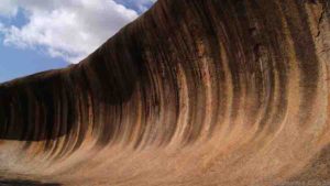
Wave Rock, Australia
Wave Rock (Credit: cardboardbird, CC by 3.0)
This concave rock is 14 m high and 110 m long. It is part of the northern side of Hyden Rock, a giant granite outcrop over 2.7 billion years old, located in Hyden Wildlife Park in Western Australia.
The wave is believed to have formed by the action of running water on granite. The colourful streaks on its face are made of minerals left behind by rainwater run-off.
Giant’s Causeway, Northern Ireland
The Giant’s Causeway in Northern Ireland (Credit: Stephen Emerson / Alamy)
These massive hexagonal black basalt columns rise like steps and interlock neatly. There are over 40,000.
They probably formed after volcanic activity 50-60 million years ago. The sizes of the columns were most likely determined by the speed at which the erupted lava cooled.
The Wave, Vermillion Cliffs National Monument (Credit: Paul Kordwig, CC by 3.0)
Popular among hikers, Vermillion Cliffs is a treasure trove of deep canyons and steep cliffs. It is also home to “The Wave” (pictured), which is made up of undulating sandstone.
The Monument is located on the Colorado Plateau, and gets its rich reddish hues from the sandstone that formed the landscape. The colours of the site change as the day progresses.
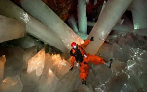
Cave of the Crystals, Mexico
Cave of the Crystals – Naica, Mexico
This cave contains gigantic, sword-like gypsum crystals. It is 300m underground in the Naica Mine in the Mexican state of Chihuahua. It was discovered by two brothers drilling for lead and silver.
The enormous crystals are believed to have formed when gypsum-saturated groundwater flowed through the caves, and was heated and cooled by hot magma below. Some of the largest crystals may be over 500,000 years old.
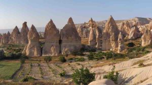
Fairy chimneys (Credit: Benh Lieu Song, CC by 3.0)
These strange conical spires are found in the Cappadocia region of Turkey.
Several million years ago, active volcanoes spewed volcanic ash that covered the ground. Rainwater and wind eroded the soft compressed volcanic ash, leaving behind the harder overlying basalts, forming the fairy chimneys.
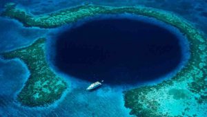
The Great Blue Hole, Belize
This underwater sinkhole is 320 m wide and 125 m deep, and a major scuba diving attraction. It is part of the Belize Barrier Reef, which is in turn part of the Mesoamerican Reef.
This hole is believed to have formed during the recent ice ages, when a submerged limestone cave system collapsed due to changes in the sea level. Huge stalactites and stalagmites are found in the hole, which contain records of past climates.
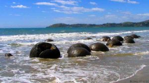
Resembling giant turtle shells, these spherical boulders lie strewn on New Zealand’s Koekohe Beach.
These boulders started forming in sediments on the sea floor over 60 million years ago. Carbonates built up around a central core, similar to the way pearls form around a speck of grit.
According to Maori legends, the boulders are remnants of gourds and eel baskets, washed ashore from the wreck of a sailing canoe.
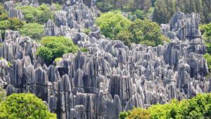
Stone Forest, China
The Stone Forest in China (Credit: Udayan Dasgupta)
Blade-like columns of limestone, many over 10 m tall, form a landscape that resembles a forest of stones. The region is a UNESCO World Heritage Site.
The stone forests formed some 270 million years ago in what was once a shallow sea. Sandstone and limestone accumulated in the basin, and was eventually pushed up into the air. The rocks were then shaped by wind and water to create these spectacular stone pillars.
Valley of the Moon, Argentina
The “Submarine” formation in the Valley of the Moon (Credit: AHLN, CC by 2.0)
Arid and rugged, this barren landscape looks like – you guessed it – the surface of the Moon. But it is actually a fossil graveyard.
The site contains undisturbed deposits from 250-200 million years ago. Fossils of some of the oldest dinosaurs, fish, amphibians, reptiles and over 100 species of plants have been found. There are also huge petrified tree trunks.
Chocolate Hills, the Philippines
The Chocolate Hills (Credit: LOOK Die Bildagentur der Fotografen GmbH / Alamy)
There are about 1500 of these limestone mounds in Bohol province in the Philippines. They are normally covered by grass, but turn a deep-brown colour during the dry season.
In 1988, the Chocolate Hills were declared the Philippines’ third National Geological Monument.
Eye of the Sahara, Mauritania
The Eye of the Sahara (Credit: NASA / JPL / NIMA)
Formally known as the Richat Structure, the Eye of the Sahara looks like a bullseye from above.
Located in the Sahara desert, it is a dome-shaped rock structure about 50 km across. Once thought to have been caused by a meteorite impact, it is now believed to have formed from uplifted rock that was later eroded.
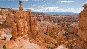
Bryce Canyon National Park, Utah
Bryce Canyon (Credit: Luca Galuzzi, CC by 2.5)
Located on the Colorado Plateau, the Bryce Canyon in southern Utah is a natural amphitheatre filled with spires and hoodoos. The Paiute Native Americans called it “red rocks standing like men in a bowl-shaped canyon”.
The hoodoos were formed when water repeatedly froze and melted in the vertical cracks of sedimentary rocks. Some hoodoos are taller than a 10-storey building.
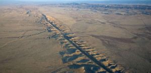
San Andreas Fault, California
Aerial photo of the San Andreas Fault in the Carrizo Plain, northwest of Los Angeles. Credit: Wikipedia.
This is one giant fracture on the earth’s crust, nearly 1,300 km long. The fault line began forming over 30 million years ago when two massive tectonic plates – the Pacific and North American – collided.
A major earthquake may well strike the San Andreas Fault in the coming decades.
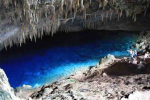
Blue Lake Cave, Brazil
Blue Lake Cave, Brazil
Blue Lake Cave is a cave located in Bonito, Mato Grosso do Sul, Brazil. The cave has been listed as a protected area by IPHAN since 1978.
Gruta Do Lago Azul, or the Blue Lake Grotto, the large cave is filled with a pool of astonishingly clear blue water. Thought to be over 200 feet deep, the water turns a particularly beautiful blue when sunlight shines through a hole in the ceiling of the cave, and makes the water shimmer in the light.
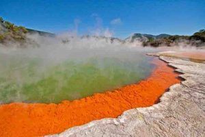
Champagne Pool, New Zealand
Champagne Pool is a prominent geothermal feature within the Waiotapu geothermal area in the North Island of New Zealand.
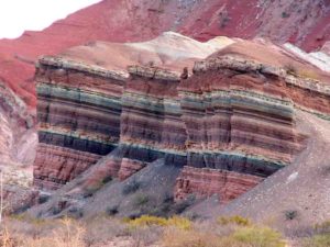
Cerro de los Siete Colores “The Hill of Seven Colors”, Argentina
Cerro de los Siete Colores The Hill of Seven Colors, Argentina
Cerro de los Siete Colores (The Hill of Seven Colors) is one of the hills bordering the Quebrada de Purmamarca which is in turn is a western branch of the Quebrada de Humahuaca up to Cuesta del Lipán, in Jujuy Province, Argentina.
Marble Caves, Chile
Marble Caves, Argentina
The Marble Caves is geological formation of unusual beauty. These caves have formed in a pure marble and are bathed in the deep blue water of General Carrera Lake
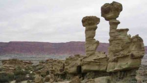
The Paria Mountains, United States
The Paria Mountains, United States
Paria or Pahreah, is a ghost town on the Paria River in Grand Staircase-Escalante National Monument in central Kane County, Utah, United States. It was inhabited from 1870 to 1929, and later used as a filming location.
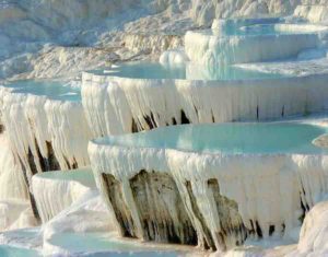
Travertine Hot Springs at Pamukkale, Turkey
Travertine Hot Springs at Pamukkale, Turkey
Pamukkale, meaning “cotton castle” in Turkish, is a natural site in Denizli Province in southwestern Turkey. The city contains hot springs and travertines, terraces of carbonate minerals left by the flowing water. It is located in Turkey’s Inner Aegean region, in the River Menderes valley, which has a temperate climate for most of the year.
Travertine terrace formations at Pamukkale, Turkey. May 21, 2011
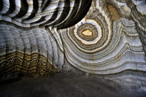
The Realmonte Salt Mine in Sicily, Italy
There are currently three salt mines Realmonte in the province of Agrigento and Racalmuto and Petralia, in the province of Palermo, managed by the company Italkali . The Realmonte field, overlooking the southern coast of Sicily, about four
kilometers from Agrigento and a kilometer from Porto Empedocle.
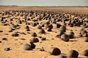
Watermelon Valley, Egypt
“Watermelon Valley” Chert nodules of the Drunka Formation (Lower Eocene) are mostly spherical, have diameters from 40 to 120 cm, are quasi-uniformly spaced 2–3 m apart in the plane of bedding, have concentric internal structure and, except for rare small (<6 cm) solid chert nodules, are less than 85% chertified.
The Twelve Apostles is a collection of limestone stacks off the shore of the Port Campbell National Park, by the Great Ocean Road in Victoria, Australia. Their proximity to one another has made the site a popular tourist attraction.
The newly discovered marine lizard, named Primitivus manduriensis, hunted in the shallow waters of what is now Puglia, Italy, 70 to 75 million years ago. Credit: Fabio Manucci
University of Alberta paleontologists discovered a new species of marine lizard that lived 70 to 75 million years ago, with its muscle and skin remarkably well preserved.
The fossil is a dolichosaur, a marine lizard related to snakes and mosasaurs. Called Primitivus manduriensis, it was found in Puglia, Italy, and named after the local Manduria variety of red wine grape primitivo.
The fossil was discovered in what was once a shallow water environment. After it died, the lizard fell to the bottom and was covered in sediment, safe from the moving water that would otherwise have scattered its remains. And with no apparent predators around to feed on the carcass, it remained largely intact.
“(The marine lizards) are essentially small, long-bodied animals that look like regular lizards with longer necks and tails,” explained Ph.D. student Ilaria Paparella, lead author of the study detailing the discovery. “They have paddle-like hands and feet for swimming but could also move on land.”
The fossil is significantly younger than other existing specimens from the group, extending the time range of their existence by about 15 million years.
For Paparella, one of the most interesting things about the specimen was the ability to study the soft tissues, including scales, muscle and skin. She conducted the research as part of her Ph.D. with U of A paleontologist Michael Caldwell, chair of the Department of Biological Sciences.
“There need to be very special conditions for soft tissue to be preserved on a fossil,” she explained. “The location where the Primitivus manduriensis was found has a great deal of potential. We hope to get permits from the Italian authorities to conduct further fieldwork.
“This was the first time I’ve ever had the opportunity to look at the complete picture of a beautifully preserved specimen, right down to the scales,” added Paparella. “For living species, scientists use scale patterns and skin for identification. It was unique to be using these techniques to look at a specimen that died 70 million years ago.”
The paper, “A New Fossil Marine Lizard With Soft Tissues From the Late Cretaceous of Southern Italy,” was published in Royal Society Open Science.
Reference:
Ilaria Paparella et al. A new fossil marine lizard with soft tissues from the Late Cretaceous of southern Italy, Royal Society Open Science (2018). DOI: 10.1098/rsos.172411
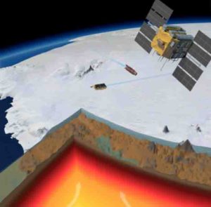
A picture of Amundsen Sea Embayment in West Antarctica with the ice sliced to show the bedrock and the earth cut to show the crust (brown) the bottom of the lithosphere (red area) and the mantle (yellow). The color gradient indicate the temperature from hot (bright yellow) to relatively cool (dark red). In space we see three satellites flying, from the right, a GPS satellite, GOCE, which measures the static gravity, and Cryosat2, which measures the changes in ice thickness. The ice thickness and the bedrock data are from BEDMAP2, the mantle temperature and the crustal thickness is derived from GOCE (data from Folker Pappa). Illustration credit: Planetary Visions/ESA Illustration text: VR. Barletta.
An international team of researchers, with a new study published in Science with DTU Space as lead author, finds that the bedrock below the West Antarctic Ice Sheet is rising much more rapidly than expected, revealing a very different Earth structure than previously believed. This discovery has important implications in understanding the past, present and future climate changes in Antarctica.
The unexpectedly fast rate of the rising earth may increase the stability of the ice sheet against catastrophic collapse due to ice loss. At the same time the rapid rise, known as uplift, also affects gravity measurements. This implies that up to 10 percent more ice has melted off the West Antarctica Ice Sheet (WAIS) than previously assumed.
“The results of our work will provide a very important contribution in the understanding of dynamics of the Earth along with the ice melting processes in Antarctica,” said leading author of this new study, postdoctoral researcher Valentina R. Barletta at DTU Space, the National Space Institute at the Technical University of Denmark.
The Amundsen Sea Embayment (ASE) in West Antarctica alone contributes to 25 percent of all water estimated from melting ice on our planet. To make numbers easier to understand, in one year ASE loses enough to cover an area the size of Denmark (43.000 square km) with a 2.8 meters high layer of ice. The same area (ASE) holds enough ice to potentially raise the global sea level by 1.2 meters or to cover an area the size of Denmark with 11 km of ice.
“The large amount of water stored in Antarctica has implications for the whole planet, but especially for northern Europe”, said Barletta, “because of a combination of gravitational effects, surprisingly, the ice lost in Antarctica mostly raises the sea level here, in northern Europe. In contrast, the ice lost in Greenland has no effect here, but it raises the sea level in the southern hemisphere and further destabilizes the WAIS.”
“The uplift velocity in ASE was measured at up to 41 millimeters per year, one of the fastest rates ever recorded in glaciated areas. In comparison, the GPS stations installed nearby the Greenland ice streams record up to 30 millimeters per year, but we know that it is caused by an immediate elastic rebound of the earth, acting like a spring” said Abbas Khan, one of the coauthors and associate professor at DTU Space.
Participating researchers led by scientists at the Ohio State University (OSU) installed a series of GPS stations on rock outcrops around the ASE to measure its rise in response to thinning ice. “The rapid rise of the bedrock in this part of Antarctica suggests that the geology underneath the ice is different from what scientists had previously believed. The rate of uplift we found is unusual and very surprising. It’s a game changer,” said Terry Wilson, one of the leaders of the study and professor emeritus of Earth Sciences at OSU.
Under the massive weight of ice the earth subsides. “When the ice melts and gets thinner, the earth readjusts, and rises immediately by a few millimeters, which depends on the ice lost,” explains Valentina Barletta. “But the earth also acts a bit like a very hard memory-foam mattress. And it slowly keeps readjusting for several thousand years after the melting. In Scandinavia the bedrock is still rising about 10 millimeters per year because of the last ice age.”
Scientists call this delayed readjustment Glacial Isostatic Adjustment (GIA), which can also be described as the Earth retaining memory of the ice lost in the past. How fast this readjustment takes place, depends on the properties of the mantle, the portion inside the earth between the crust and the core that is 2900 kilometers thick.
“Thanks to the satellite observations, we were able to estimate the current ice thinning in ASE, and conclude that the measured uplift rate is up to 4 times larger than expected based on the current ice melting rates”, says Barletta. Therefore the new study focused on the delayed readjustment of the Earth.
Valentina R. Barletta has run thousands of GIA simulations using different possible combinations of Earth properties and ice loss scenarios and found that the only way to produce such high uplift is for the Earth mantle to be very fluid (technically low viscosity).
“Normally we would see significant uplift happen slowly over thousands of years after the ice age, but here we see it take place in centuries or even decades. This tells us that the mantle below is very fluid and moves quickly when the weight of the ice is taken off,” said Barletta. And the uplift is getting faster. According to this new study, in 100 years, the uplift rates at the GPS sites will be 2.5 to 3.5 times more rapid than currently observed.
Among the direct consequences of this study there is a revised estimate of the ice loss in ASE. When a massive amount of the ice melts it reduces the local gravity and leaves fingerprints that can be measured by satellites and used to estimate the total mass lost. But the earth’s readjustment also produces a gravity change that partially compensates for this loss and hides the ice signal. “Now we know that in ASE the earth readjusts so fast that 10 percent of the ice loss was hidden, but now we can fix that,” said Barletta.
The fast earth response is potential good news for the future of the WAIS. In this area of Antarctica most of the ice is grounded below sea level, and therefore vulnerable to melting from below by ocean water flowing in underneath the ice sheet. Here the earth uplift works as a feedback that can slow down the ice retreat in different ways.
The uplift raises the so called ‘pinning points’ – elevated features that pin the ice sheet to the bedrock, preventing the retreat of the grounded ice. At the same time the uplift changes the inland slope of the ground that becomes more effective in holding the ice from sliding away. In addition, the massive amount of the ice lost reduces the local gravity and the gravitational pull on the water, resulting in a lower sea level at the adjacent Antarctic coast. This in turn reduces the buoyancy of the whole ice sheet, promoting the stability of the ice sheet.
Modeling studies have shown that bedrock uplift could theoretically protect WAIS from collapse, at least in case of moderate climate changes. But it was believed that the process would take too long to have practical effects.
The mantle that we discovered under ASE is more fluid and hotter, and therefore the earth uplifts faster than in the most optimistic hypotheses used in previous studies. “Under many realistic climate models, this should be enough to stabilize the ice sheet,” Wilson said. But, if future global warming is too extreme, according to the scientists the WAIS will most likely still collapse regardless of stabilizing feedbacks.
“Apart from giving us a new picture of the earth dynamics in Antarctica, the new findings will push to improve ice models for WAIS to get a more precise picture of what will happen in the future” said Barletta. “They also tell that we clearly need to improve our knowledge of the Earth structure under the whole Antarctic continent. To do so we use GPS in the few areas where they can be installed, and elsewhere we use data from ESA’s Earth Explorer GOCE and seismic tomography.”
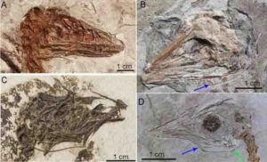
Incredible fossils discovered in Northeast China with the hyoid bones preserved. The blue and green arrows are pointing to the hyoid apparatus. Credit: Li et al. 2018
Dinosaurs are often depicted as fierce creatures, baring their teeth, with tongues wildly stretching from their mouths like giant, deranged lizards. But new research reveals a major problem with this classic image: Dinosaurs couldn’t stick out their tongues like lizards. Instead, their tongues were probably rooted to the bottoms of their mouths in a manner akin to alligators.
Researchers from The University of Texas at Austin and the Chinese Academy of Sciences made the discovery by comparing the hyoid bones — the bones that support and ground the tongue — of modern birds and crocodiles with those of their extinct dinosaur relatives. In addition to challenging depictions of dino tongues, the research proposes a connection on the origin of flight and an increase in tongue diversity and mobility.
The research was published June 20 in the journal PLOS ONE.
“Tongues are often overlooked. But, they offer key insights into the lifestyles of extinct animals,” said lead author Zhiheng Li, an associate professor at the Key Laboratory of Vertebrate Evolution and Human Origins of the Chinese Academy of Sciences.He conducted the work while earning his Ph.D. at the UT Jackson School of Geosciences.
The researchers made their discovery by comparing the hyoid bones of extinct dinosaurs, pterosaurs and alligators to the hyoid bones and muscles of modern birds and alligator specimens. Hyoid bones act as anchors for the tongue in most animals, but in birds these bones can extend to the tip. Because extinct dinosaurs are related to crocodiles, pterosaurs and modern birds, comparing anatomy across these groups can help scientists understand the similarities and differences in tongue anatomy and how traits evolved through time and across different lineages.
The comparison process involved taking high-resolution images of hyoid muscles and bones from 15 modern specimens, including three alligators and 13 bird species as diverse as ostriches and ducks, at the Jackson School’s High-Resolution X-Ray Computed Tomography Facility (UTCT). The fossil specimens, most from northeastern China, were scrutinized for preservation of the delicate tongue bones and included small bird-like dinosaurs, as well as pterosaurs and a Tyrannosaurus rex.
The results indicate that hyoid bones of most dinosaurs were like those of alligators and crocodiles — short, simple and connected to a tongue that was not very mobile. Co-author and Jackson School Professor Julia Clarke said that these findings mean that dramatic reconstructions that show dinosaurs with tongues stretching out from between their jaws are wrong.
“They’ve been reconstructed the wrong way for a long time,” Clarke said. “In most extinct dinosaurs their tongue bones are very short. And in crocodilians with similarly short hyoid bones, the tongue is totally fixed to the floor of the mouth.”
Clarke is no stranger to overturning dinosaur conventions. Her 2016 study on dinosaur vocalizations found evidence that large dinosaurs might make booming or cooing sounds, similar to the sounds made by crocodiles and ostriches.
In contrast to the short hyoid bones of crocodiles, the researchers found that pterosaurs, bird-like dinosaurs, and living birds have a great diversity in hyoid bone shapes. They think the range of shapes could be related to flight ability, or in the case of flightless birds such as ostriches and emus, evolved from an ancestor that could fly. The researchers propose that taking to the skies could have led to new ways of feeding that could be tied to diversity and mobility in tongues.
“Birds, in general, elaborate their tongue structure in remarkable ways,” Clarke said. “They are shocking.”
That elaboration could be related to the loss of dexterity that accompanied the transformation of hands into wings, Li said.
“If you can’t use a hand to manipulate prey, the tongue may become much more important to manipulate food,” Li said. “That is one of the hypotheses that we put forward.”
The scientists note one exception linking tongue diversity to flight. Ornithischian dinosaurs — a group that includes triceratops, ankylosaurs and other plant-eating dinosaurs that chewed their food — had hyoid bones that were highly complex and more mobile, though they were structurally different from those of flying dinosaurs and pterosaurs.
Further research on other anatomical changes that occurred with shifts in tongue function could help improve our knowledge of the evolution of birds, Clarke said, giving an example of how changes in the tongues of living birds are associated with changes in the position of the opening of the windpipe. These changes could in turn affect how birds breathe and vocalize.
However, the researchers note that the fossil record as yet can’t pin down when these changes to the windpipe occurred.
“There is more work to be done,” Li said.
The study was funded by the Chinese Academy of Sciences, The University of Texas at Austin, the Smithsonian Institution and the Gordon and Betty Moore Foundation.
Reference:
Zhiheng Li, Zhonghe Zhou, Julia A. Clarke. Convergent evolution of a mobile bony tongue in flighted dinosaurs and pterosaurs. PLOS ONE, 2018; 13 (6): e0198078 DOI: 10.1371/journal.pone.0198078
Two new Ediacaran-era fossils discovered by UCR researchers: Obamus coronatus (left) and Attenborites janeae. Credit: Image courtesy of University of California Riverside
Earth’s first complex animals were an eclectic bunch that lived in the shallow oceans between 580-540 million years ago.
The iconic Dickinsonia — large flat animals with a quilt-like appearance — were joined by tube-shaped organisms, frond-like creatures that looked more like plants, and several dozen other varieties already characterized by scientists.
Add to that list two new animals discovered by a UC Riverside-led team of researchers:
Obamus coronatus, a name that honors President Barack Obama’s passion for science. This disc-shaped creature was between 0.5-2 cm across with raised spiral grooves on its surface. Obamus coronatus did not seem to move around, rather it was embedded to the ocean mat, a thick layer of organic matter that covered the early ocean floor.
Attenborites janeae, named after the English naturalist and broadcaster Sir David Attenborough for his science advocacy and support of paleontology. This tiny ovoid, less than a centimeter across, was adorned with internal grooves and ridges giving it a raisin-like appearance.
The discovery of Obamus coronatus was published online June 14 in the Australian Journal of Earth Sciences, or AJES, and the Attenborites janeae paper is forthcoming in the same journal. The studies were led by Mary Droser, a professor of paleontology in UCR’s Department of Earth Sciences. Both papers will be included in print in a 2019 thematic AJES issue focusing on South Australia’s Flinders Ranges region, where the discoveries were made.
Part of the Ediacara Biota, the soft-bodied animals are visible as fossils cast in fine-grained sandstone that have been preserved for hundreds of millions of years. These Precambrian lifeforms represent the dawn of animal life and are named after the Ediacara Hills in the Flinders Ranges, the first of several areas in the world where they have been found.
In the hierarchical taxonomic classification system, the Ediacara Biota are not yet organized into families, and little is known about how they relate to modern animals. About 50 genera have been described, which often have only one species.
“The two genera that we identified are a new body plan, unlike anything else that has been described,” Droser said. “We have been seeing evidence for these animals for quite a long time, but it took us a while to verify that they are animals within their own rights and not part of another animal.”
The animals were glimpsed in a particularly well-preserved fossil bed described in another paper published by Droser’s group that will be included in the Flinders Ranges issue of AJES. The researchers dubbed this fossil bed “Alice’s Restaurant Bed,” a tribute to the Arlo Guthrie song and its lyric, “You can get anything you want at Alice’s Restaurant.”
“I’ve been working in this region for 30 years, and I’ve never seen such a beautifully preserved bed with so many high quality and rare specimens, including Obamus and Attenborites,” Droser said. “The AJES issue on the Flinders Ranges will support South Australia’s effort to obtain World Heritage Site status for this area, and this new bed demonstrates the importance of protecting it.”
References:
P. W. Dzaugis, S. D. Evans, M. L. Droser, J. G. Gehling, I. V. Hughes. Stuck in the mat: Obamus coronatus, a new benthic organism from the Ediacara Member, Rawnsley Quartzite, South Australia. Australian Journal of Earth Sciences, 2018; 1 DOI: 10.1080/08120099.2018.1479306
S. D. Evans, P. W. Dzaugis, M. L. Droser, J. G. Gehling. You can get anything you want from Alice’s Restaurant Bed: exceptional preservation and an unusual fossil assemblage from a newly excavated bed (Ediacara Member, Nilpena, South Australia). Australian Journal of Earth Sciences, 2018; 1 DOI: 10.1080/08120099.2018.1470110
The new species of fossil chancelloriid: an enigmatic animal from the Cambrian Period with a tube-like body, ‘minotaur-horn’ spines, and doughnut-shaped scars. Credit: Derek Siveter/Tom Harvey/Peiyun Cong
Scientists have discovered the fossil of an unusual large-bodied sponge-like sea-creature from half a billion years ago.
The creature belongs to an obscure and mysterious group of animals known as the chancelloriids, and scientists are unclear about where they fit in the tree of life.
They represent a lineage of spiny tube-shaped animals that arose during the Cambrian evolutionary “explosion” but went extinct soon afterwards. In some ways they resemble sponges, a group of simple filter-feeding animals, but many scientists have dismissed the similarities as superficial.
The new discovery by a team of scientists from the University of Leicester, the University of Oxford and Yunnan University, China, adds new evidence that could help solve the mystery.
The researchers have published their findings in the Royal Society journal Proceedings of the Royal Society B. The Leicester authors are Tom Harvey, Mark Williams, David Siveter & Sarah Gabbott.
The new species, named Allonnia nuda, was discovered in the Chengjiang deposits of Yunnan Province, China. It was surprisingly large in life (perhaps up to 50 cm or more) but had only a few very tiny spines. Its unusual “naked” appearance suggests that further specimens may be “hiding in plain sight” in fossil collections, and shows that this group was more diverse than previously thought.
Furthermore, the new species holds clues about the pattern of body growth, with clear links to modern sponges. It is too soon to say the mystery has been solved, but the discovery highlights the central role of sponge-like fossils in the debate over earliest animal evolution.
Dr Tom Harvey, from the University of Leicester’s School of Geography, Geology and the Environment, explained: “Fossil chancelloriids were first described around 100 years ago, but have resisted attempts to place them in the tree of life. We argue that their pattern of body growth supports a link to sponges, reinvigorating an old hypothesis. We’re not suggesting that it’s “case closed” for chancelloriids, but we hope our results will inspire new research into the nature of the earliest animals.”
Dr Peiyun Cong, from the Yunnan Key Laboratory for Palaeobiology, Kunming, China, and The Natural History Museum, UK, added: “The Chengjiang deposits of Yunnan Province continue to reveal surprising new fossils we could hardly have imagined. Together, they provide a crucial snapshot of life in the oceans during the Cambrian explosion.”
Reference:
Pei-Yun Cong, Thomas H. P. Harvey, Mark Williams, David J. Siveter, Derek J. Siveter, Sarah E. Gabbott, Yu-Jing Li, Fan Wei, Xian-Guang Hou. Naked chancelloriids from the lower Cambrian of China show evidence for sponge-type growth. Proceedings of the Royal Society B: Biological Sciences, 2018; 285 (1881): 20180296 DOI: 10.1098/rspb.2018.0296
Aerial photo of the San Andreas Fault in the Carrizo Plain, northwest of Los Angeles. Credit: Wikipedia.
Geologists have long thought that the central section of California’s famed San Andreas Fault — from San Juan Bautista southward to Parkfield, a distance of about 80 miles — has a steady creeping movement that provides a safe release of energy.
Creep on the central San Andreas during the past several decades, so the thinking goes, has reduced the chance of a big quake that ruptures the entire fault from north to south.
However new research by two Arizona State University geophysicists shows that the earth movements along this central section have not been smooth and steady, as previously thought.
Instead, the activity has been a sequence of small stick-and-slip movements — sometimes called “slow earthquakes” — that release energy over a period of months. Although these slow earthquakes pass unnoticed by people, the researchers say they can trigger large destructive quakes in their surroundings. One such quake was the magnitude 6 event that shook Parkfield in 2004.
“What looked like steady, continuous creep was actually made of episodes of acceleration and deceleration along the fault,” says Mostafa Khoshmanesh, a graduate research assistant in ASU’s School of Earth and Space Exploration (SESE). He is the lead author of a Nature Geoscience paper reporting on the research.
“We found that movement on the fault began every one to two years and lasted for several months before stopping,” says Manoochehr Shirzaei, assistant professor in SESE and co-author of the paper.
“These episodic slow earthquakes lead to increased stress on the locked segments of the fault to the north and south of the central section,” Shirzaei says. He points out that these flanking sections experienced two magnitude 7.9 earthquakes, in 1857 (Fort Tejon) and 1906 (San Francisco).
The scientists also suggest a mechanism that might cause the stop-and-go movements.
“Fault rocks contain a fluid phase that’s trapped in gaps between particles, called pore spaces,” Khoshmanesh says. “Periodic compacting of fault materials causes a brief rise in fluid pressure, which unclamps the fault and eases the movement.”
Looking underground from Earth orbit
The two scientists used synthetic aperture radar data from orbit for the years 2003 to 2010. This data let them map month-to-month changes in the ground along the central part of the San Andreas. They combined the detailed ground movement observations with seismic records into a mathematical model. The model let them explore the driving mechanism of slow earthquakes and their link to big nearby quakes.
“We found that this part of the fault has an average movement of about three centimeters a year, a little more than an inch,” says Khoshmanesh. “But at times the movement stops entirely, and at other times it has moved as much as 10 centimeters a year, or about four inches.”
The picture of the central San Andreas Fault emerging from their work suggests that its stick-and-slip motion resembles on a small timescale how the other parts of the San Andreas Fault move.
They note that the new observation is significant because it uncovers a new type of fault motion and earthquake triggering mechanism, which is not accounted for in current models of earthquake hazards used for California.
As Shirzaei explains, “Based on our observations, we believe that seismic hazard in California is something that varies over time and is probably higher than what people have thought up to now.” He adds that accurate estimates of this varying hazard are essential to include in operational earthquake forecasting systems.
As Khoshmanesh says, “Based on current time-independent models, there’s a 75% chance for an earthquake of magnitude 7 or larger in both northern and southern California within next 30 years.”
Reference:
Mostafa Khoshmanesh, Manoochehr Shirzaei. Episodic creep events on the San Andreas Fault caused by pore pressure variations. Nature Geoscience, 2018; DOI: 10.1038/s41561-018-0160-2
Lemurs, lorises and galagoes have nails on most digits and grooming claws on their second toes, as seen on the feet of two greater slow lorises, Nycticebus coucang, in the Florida Museum mammals collection. Credit: Florida Museum photo by Kristen Grace
Humans and other primates are outliers among mammals for having nails instead of claws. But how, when and why we transitioned from claws to nails has been an evolutionary head-scratcher.
Now, new fossil evidence shows that ancient primates — including one of the oldest known, Teilhardina brandti — had specialized grooming claws as well as nails. The findings overturn the prevailing assumption that the earliest primates had nails on all their digits and suggest the transition from claws to nails was more complex than previously thought.
“We had just assumed nails all evolved once from a common ancestor, and in fact, it’s much more complicated than that,” said Jonathan Bloch, study co-author and Florida Museum of Natural History curator of vertebrate paleontology at the University of Florida.
The findings are scheduled to be published today in the Journal of Human Evolution.
Grooming in mammals is not just about looking good. Thick body hair is a haven for ticks, lice and other parasites — possible health threats, as well as nuisances. Having a specialized claw for removing pests would be an evolutionary advantage, said Doug Boyer, an associate professor in the department of evolutionary anthropology at Duke University and the study’s lead author.
It’s one that has been retained in many primates. Lemurs, lorises, galagoes and tarsiers have nails on most of their digits and grooming claws on their second — and in tarsiers, second and third — toes.
So, why did the ancestors of monkeys, apes and humans lose their grooming claws? One possible answer: because we have each other.
“The loss of grooming claws is probably a reflection of more complex social networks and increased social grooming,” Boyer said. “You’re less reliant on yourself.”
This could explain why more solitary monkey species, such as titi and owl monkeys, have re-evolved a grooming claw, he said.
Researchers had thought grooming claws likely developed independently several times along the lines that gave rise to living primates. But these fossils suggest grooming claws were hallmark features of the earliest primates, dating back at least 56 million years.
They also come from five different genera of ancient primates that belonged to the omomyoids, the ancestors of monkeys, apes, humans and tarsiers — not the branch of primates that gave rise to lemurs, lorises and galagoes.
In 2013, Boyer was at the University of California Museum of Paleontology, sifting through sediment collected in Wyoming several decades earlier, when he found several curious primate fossils. They were distal phalanges, the bones at the tips of fingers and toes, from omomyoids. The shape of these bones reveals whether they support a claw or nail. Bones topped with a claw mimic its narrow, tapered structure while bones undergirding a nail are flat and wide. The distal phalanges that Boyer discovered looked like they belonged to animals with grooming claws.
“Prior to this study, no one knew whether omomyoids had grooming claws,” Boyer said. “Most recent papers came down on the side of nails.”
Meanwhile, Bloch, picking through collections recently recovered from Bighorn Basin, Wyoming, came across what looked like a “strange, narrow nail” bone. But when he compared it to modern primates, “it looked just like a tarsier grooming claw.” Smaller than a grain of rice, it matched the proportions of Teilhardina brandti, a mouse-sized, tree-dwelling primate.
Bloch and Boyer had co-authored a 2011 study describing the first fossil evidence of nails in Teilhardina. At the time, they believed the primate had nails on all its digits. Now, fossils were making them reevaluate their assumptions, not only about Teilhardina, but other omomyoids.
On the off-chance that they could add one more ancient primate to the growing list of claw-bearers, the pair drove out to Omomys Quarry, Wyoming, once inhabited by another genus of omomyoid, Omomys.
“We spent a day combing that site, never expecting to find something as tiny and delicate as a grooming claw,” Boyer said.
The team picked one right off the surface. They had found grooming claws at three independent sites from omomyoids spanning about 10 million years in the fossil record.
“That was the last nail in the coffin,” Boyer said.
Why did primates develop nails at all? The question is a contentious one, but Bloch and Boyer think the transition away from claws could have mirrored changes in primate movement. As we ramped up climbing, leaping and grasping, nails might have proven more practical than claws, which could snag or get in the way.
Grooming claws might seem insignificant, but they can provide crucial insights into ancient primates, many of which are known only from fossil teeth, Bloch said. These tiny claws offer clues about how our earliest ancestors moved through their environment, whether they were social or solitary and what their daily behavior was like.
“We see a bit of ourselves in the hands and feet of living primates,” Bloch said. “How they got this way is a profoundly important part of our evolutionary story.”
Reference:
Doug M. Boyer, Stephanie A. Maiolino, Patricia A. Holroyd, Paul E. Morse, Jonathan I. Bloch. Oldest evidence for grooming claws in euprimates. Journal of Human Evolution, 2018; DOI: 10.1016/j.jhevol.2018.03.010
Reconstruction of Shartegosuchus. Credit Artist: Viktor Rademacher
The mouth of today’s crocodilians inspires fear and awe, with their wide gape and the greatest known bite force in the vertebrate animal kingdom. However, this apex predator of today and its modus of attack (its mouth) had humble beginnings.
The very earliest crocodilians were very different to the beasts we know well today, they were much smaller bodied, slender and had longer legs. It is speculated that they led a much different lifestyle to the crocodiles we all know and fear today.
A new study by a team of international experts, led by University of Witwatersrand PhD candidate Kathleen Dollman and Professor Jonah Choiniere published today in the American Museum Novitates, endeavoured to further explore the mouth of one of the earliest occurring and least understand groups of crocodilians, the shartegosuchids.
In 2010, Choiniere was a part of a field team working in the Late Jurassic (±160 mya) exposures in the western Gobi in Mongolia, when he found the fossil of a small snout of a shartegosuchid. This work was co-authored by researchers based at the American Museum of Natural History, the George Washington University and the Institute for Vertebrate Palaeontology and Palaeoanthropology.
The snout was later CT scanned at the American Museum of Natural History, exposing an unusual, closed secondary palate. Crocodilians are one of only a few groups of animals that evolve a completely closed, bony secondary palate (along with turtles and mammals). A closed secondary palate has many biological implications for crocodilians, including breathing whilst under water and reinforcing the skull to allow for their incredible bite force.
This study showed that these early crocodilians, the shartegosuchids, are important because they evolved a completely closed secondary palate much earlier than previously thought. This is an interesting example of convergent evolution, whereby a similar feature evolves independently in two completely unrelated groups. The advent of a convergent evolutionary event allows scientists to test questions about why that feature evolved and even the function of that feature which in this case is the first step in understanding the purpose of a closed secondary palate in crocodilians.
“I was surprised to find that there were many features in the palate and snout that were completely different between shartegosuchids and extant crocodilians,” says Dollman. Shartegosuchids have a thickened and sculptured palate together with a tall and short rostrum, whereas extant crocodilians have a smooth palate with a long and broad rostrum.
“We would expect to see the same palatal structures and snout shapes in both shartegosuchids and extant crocodiles if they were using it for similar functions and had evolved a closed palate for similar reasons,” says Dollman. “The observed differences tell us that shartegosuchids likely had predation practices to which there is no modern analogue in crocodilians.”
“It’s been nearly 10 years since we collected this fossil after driving 5 days across the Gobi Desert,” said Choiniere, “and I am delighted that it’s formed a part of Kathleen’s PhD.”
Deep inside the Earth exist pockets of water, but the liquid there isn’t like the water on the surface.
When exposed to unimaginably high temperatures and pressures, water exhibits all sorts of weird phases and properties, from remaining a liquid at temperatures 10 times higher than the boiling point to existing as a liquid and a solid at the same time.
This strange world is still not fully understood, but a team of University of Chicago scientists ran quantum simulations to develop a new model of the behavior of water at extremely high temperatures and pressures. The computational measurements, published June 18 in the Proceedings of the National Academy of Sciences, should help scientists understand water’s role in the makeup of the mantle and potentially in other planets.
“Subtle physics at the molecular level can impact properties of matter deep inside planets,” said Viktor Rozsa, a UChicago graduate student and first author on the paper. “How water reacts and transports charge on a molecular scale affects our understanding of phenomena ranging from the movement of magma, water and other fluids to the magnetic field of the entire planet.”
Under the conditions considered in the study — more than 40 times hotter than our everyday conditions and 100,000 times greater than atmospheric pressure — water is regularly ripping apart and re-forming its own chemical bonds. The result is that it can interact very differently with other minerals than it does on the surface of the earth.
Scientists have been trying to pin down exactly how these atoms interact for decades: It’s extremely difficult to test experimentally, as water can react with the instrument itself. “It’s surprising how little we know about water below the crust,” said lead author Giulia Galli, the Liew Family Professor of Molecular Engineering and professor of chemistry at UChicago and a senior scientist at Argonne National Laboratory.
But water in these conditions exists throughout the mantle — it’s possible there may be more water distributed inside the Earth than there is in the oceans — and scientists would like to know exactly how it behaves in order to understand its role in the Earth and how it moves through the mantle.
Galli’s group built a model by performing quantum mechanical simulations of a small set of water molecules at extremely high pressures and temperatures — in the range of what you need to synthesize a diamond.
Their model, built with the aid of simulations performed at the Research Computing Center at UChicago, provides an explanation for some of water’s more mysterious properties at such pressures, such as the connection between bizarrely high conductivity and how its molecules disassociate and re-associate.
It also predicts and analyzes a controversial set of measurements called the vibrational spectroscopic signatures of water, or fingerprints of molecular movement that lay out how molecules are interacting and moving.
In addition to furthering understanding of our own planet, Galli said, “the ability to do the kind of simulations performed in our paper could have important consequences on modeling exoplanets.” Many scientists, including those at UChicago, are narrowing the conditions for distant planets that might have the conditions to create life, and much of this search revolves around water.
Galli is a member of the research team in the Institute for Molecular Engineering’s water theme, led by James Skinner, the Crown Family Professor of Molecular Engineering. The team seeks to understand the physical, chemical and biological manifestations of water, and to develop applications from innovative purification filters, to new materials for desalination and lithium ion harvesting, to new catalysts for water chemistry and disinfection.
While water is everywhere and intensively important to us, Galli said, it is notoriously difficult to simulate and study: “This is one step in the long journey to understanding.”
Reference:
Viktor Rozsa, Ding Pan, Federico Giberti, Giulia Galli. Ab initio spectroscopy and ionic conductivity of water under Earth mantle conditions. Proceedings of the National Academy of Sciences, 2018; 201800123 DOI: 10.1073/pnas.1800123115