Home Blog Page 48

The Great Unconformity : A billion years is missing from the geologic record

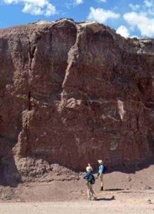
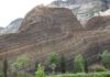
Francis Macdonald walks along a road near Manitou Springs, Colorado, where an exposed outcrop shows a feature known as the "Great Unconformity."
Francis Macdonald walks along a road near Manitou Springs, Colorado, where an exposed outcrop shows a feature known as the “Great Unconformity.”
Photo Credit: Rebecca Flowers

The geologic record is exactly that: a record. The strata of rock tell scientists about past environments, much like pages in an encyclopedia. Except this reference book has more pages missing than it has remaining. So geologists are tasked not only with understanding what is there, but also with figuring out what’s not, and where it went.

One omission in particular has puzzled scientists for well over a century. First noticed by John Wesley Powell in 1869 in the layers of the Grand Canyon, the Great Unconformity, as it’s known, accounts for more than one billion years of missing rock in certain places.

Scientists have developed several hypotheses to explain how, and when, this staggering amount of material may have been eroded. Now, UC Santa Barbara geologist Francis Macdonald and his colleagues at the University of Colorado, Boulder and at Colorado College believe they may have ruled out one of the more popular of these. Their study appears in the Proceedings of the National Academy of Sciences.

“There are unconformities all through the rock record,” explained Macdonald, a professor in the Department of Earth Science. “Unconformities are just gaps in time within the rock record. This one’s called the Great Unconformity because it was thought to be a particularly large gap, maybe a global gap.”

A leading thought is that glaciers scoured away kilometers of rock around 720 to 635 million years ago, during a time known as Snowball Earth, when the planet was completely covered by ice. This hypothesis even has the benefit of helping to explain the rapid emergence of complex organisms shortly thereafter, in the Cambrian explosion, since all this eroded material could have seeded the oceans with tremendous amounts of nutrients.

Macdonald was skeptical of this reasoning. Although analogues of the Great Unconformity appear throughout the world — with similar amounts of rock missing from similar stretches of time — they don’t line up perfectly. This casts doubt as to whether they were truly eroded by a global event like Snowball Earth.

Part of the challenge of investigating the Great Unconformity is that it happened so long ago, and the Earth is a messy system. “These rocks have been buried and eroded multiple times through their history,” Macdonald said.

Fortunately, the team was able to test this hypothesis using a technique called thermochronology. A few kilometers below the Earth’s surface, the temperature begins to rise as you get closer to the planet’s hot mantle. This creates a temperature gradient of roughly 50 degrees Celsius for every kilometer of depth. And this temperature regime can become imprinted in certain minerals.

As certain radioactive elements in rocks break down, Helium-4 is produced. In fact helium is constantly being generated, but the fraction retained in different minerals is a function of temperature. As a result, scientists can use the ratio of helium to thorium and uranium in certain minerals as a paleo-thermometer. This phenomenon enabled Macdonald and his coauthors to track how rock moved in the crust as it was buried and eroded through the ages.

“These unconformities are forming again and again through tectonic processes,” Macdonald said. “What’s really new is we can now access this much older history.”

The team took samples from granite just below the boundary of the Great Unconformity at Pikes Peak in Colorado. They extracted grains of a particularly resilient mineral, zircon, from the stone and analyzed the radio nucleotides of helium contained inside. The technique revealed that several kilometers of rock had been eroded from above this granite between 1,000 and 720 million years ago.

Importantly, this stretch of time definitively came before the Snowball Earth episodes. In fact, it lines up much better with the periods in which the supercontinent Rodinia was forming and breaking apart. This offers a clue to the processes that may have stricken these years from the geologic record.

“The basic hypothesis is that this large-scale erosion was driven by the formation and separation of supercontinents,” Macdonald said.

The Earth’s cycle of supercontinent formation and separation uplifts and erodes incredible extents of rock over long periods of time. And because supercontinent processes, by definition, involve a lot of land, their effects can appear fairly synchronous across the geologic record.

However, these processes don’t happen simultaneously, as they would in a global event like Snowball Earth. “It’s a messy process,” Macdonald said. “There are differences, and now we have the ability to perhaps resolve those differences and pull that record out.”

While Macdonald’s results are consistent with a tectonic origin for these great unconformities, they don’t end the debate. Geologists will need to complement this work with similar studies in other regions of the world in order to better constrain these events.

The mystery of the Great Unconformity is inherently tied to two of geology’s other great enigmas: the rise and fall of Snowball Earth and the sudden emergence of complex life in the Ediacaran and Cambrian. Progress in any one could help researchers finally crack the lot.

“The Cambrian explosion was Darwin’s dilemma,” Macdonald remarked. “This is a 200-year old question. If we can solve that, we would definitely be rock stars.”

Reference:
Rebecca M. Flowers, Francis A. Macdonald, Christine S. Siddoway, Rachel Havranek. Diachronous development of Great Unconformities before Neoproterozoic Snowball Earth. Proceedings of the National Academy of Sciences, 2020; 201913131 DOI: 10.1073/pnas.1913131117

Note: The above post is reprinted from materials provided by University of California – Santa Barbara. Original written by Harrison Tasoff.

A tale of two kinds of volcanoes

Why a big volcanic blow-up at the popular travel destimation Santorini 3200 years ago, but just a few hundred kilometers away, no drama at the volcanoes on Aegina , Methana and Poros islands? Thin sections of the lavas from these four volcanoes yield some of the reasons why. Some minerals only form at greater depths - and the hornblende in the lava from Aegina island indicates that the magma chambers there are deeper than the those underneath the Santorini caldera. But plate tectonics add another, hidden reason also, found research from the University of Johannesburg. Credit: Prof Marlina A. Elburg, University of Johannesburg
Why a big volcanic blow-up at the popular travel destimation Santorini 3200 years ago, but just a few hundred kilometers away, no drama at the volcanoes on Aegina , Methana and Poros islands? Thin sections of the lavas from these four volcanoes yield some of the reasons why. Some minerals only form at greater depths – and the hornblende in the lava from Aegina island indicates that the magma chambers there are deeper than the those underneath the Santorini caldera. But plate tectonics add another, hidden reason also, found research from the University of Johannesburg. Credit: Prof Marlina A. Elburg, University of Johannesburg

At an idyllic island in the Mediterranean Sea, ocean covers up the site of a vast volcanic explosion from 3200 years ago. A few hundred kilometers north-west, three other islands still have their volcanic histories from a few million years ago mostly intact. No explosions there. So why the differences between the Santorini caldera and the Aegina, Methana and Poros lava domes? Researchers used volcanic “fingerprints’ and plate tectonics research to find out why.

The end of a civilisation

A big volcano blew up about 3200 years ago, right next to where Santorini island is in Greece today. During that eruption, liquid molten rock under the ground (magma) built up immense pressure, and then erupted into a lava explosion. The impact was so intense that the volcano collapsed into a huge basin called a caldera.

What had been an island-volcano, was then overrun by ocean, an event considered partially responsible for the demise of the Minoan civilisation.

Santorini Island became a popular travel destination with big ocean-going ships sailing over the caldera. The village of Phira perches on the cliff-edge of the remains of the volcano.

As idyllic as it looks, the Santorini volcano underneath the ocean still constitutes the biggest volcanic hazard for Europe, together with the Vesuvius volcano in Italy.

Toothpaste rather than fireworks

A few hundred kilometers north-west of Santorini, in Greece’s Saronic Gulf, much closer to Athens, a completely different kind of “volcano” looks much less dramatic.

The small islands of Aegina, Methana and Poros sport rounded hills with roads winding uphill in hairpin bends. These hills have volcanic ancestry too—but they are nothing like Santorini.

Here, liquid lava didn’t explode in a big eruption.

“There is no evidence that that large dramatic events ever took place at these islands,” says Prof Marlina A. Elburg, a Geology researcher at the University of Johannesburg.

“Thick blocky lava oozed out of magma chambers under the ground at these islands between 5.3 to 2.6 million years ago, during the Pliocene. The lava was so thick, it was more like toothpaste or putty than liquid. It formed lava domes rather than lava volcanoes.

“After a few million years’ worth of weathering, they’re well camouflaged hills, but they are still considered volcanically active,” she says.

How is it possible that volcanoes so close in geological time and space can behave to differently? The researchers used several techniques to find out.

Finding volcanic ‘fingerprints’

Elburg and co-author Ingrid Smet, a Ph.D. candidate at the time, analysed samples of the lavas in new whole rock analyses, in research published in Lithos.

The study followed on their previous research on the lavas at Methana, also published in Lithos.

They looked for the ratios of very specific elements in the samples, called isotope signatures. Isotope signatures work similar to ‘fingerprints’ for lavas—they help researchers figure out what the lavas were made of, where, and when they were formed.

“Mostly the isotope signatures matched what one would expect from where the islands are located in the Aegean volcanic arc,” says Elburg.

But there were surprises too.

Subterranean recycling machine

Underneath all these volcanoes at Aegina, Methana, Poros and Santorini, something else is going on in deep inside the crust of planet Earth. Running roughly east to west underneath the Mediterranean Sea is the Aegean volcanic arc. This arc is where the African tectonic plate ‘dives under’ the Aegean microplate.

The ‘diving under’ process is called subduction by geologists. It means that one part of the cool outer crust of Earth starts moving underneath another part of the crust, getting ‘recycled’ inside the hot liquid rock of the Earth’s mantle.

The islands of Aegina, Methana, Poros and Santorini are not just islands with volcanoes. All of them are an integral part of Earth’s ‘recycling machine’ that keeps renewing the crust underneath the planet’s oceans.

This raises the question: Why do these islands have such different ‘lava histories’, even though all of them are on the edge of the Aegean plate?

Some of the answers have to do with what goes into the lava “mixes” for the volcanoes.

Variable lava mix recipes

The African plate ‘dives under’ the Aegean plate in an oceanic trench in the Mediterranean Sea. This happens very slowly at a few centimeters per year. Which means the pristine cold basalt of the down-going African plate’s crust has been soaking in ocean water for millions of years before it enters the much warmer magma underneath the over-riding Aegean plate.

“The crust of the down-going plate now consists of altered rocks, containing minerals with water in them. These minerals become unstable during subduction because of the increasing pressure and temperature, and release their water,” says Elburg.

“This water lowers the melting point of the mantle, similar to what happens when adding salt to ice. That is why the mantle under the over-riding starts to melt. It is this molten material, or magma, that flows/oozes out of volcanoes/lava domes as lava.”

Another possible ingredient of the differing lavas is sediments in the oceanic trench at the subduction zone. At the Aegean Arc the down-going plate is covered by a very thick pile of ocean sediments. Some of the sediment is former continental crust.

A lot of this sediment is ‘scraped off’ when the plate subducts and forms an accretionary (or build-up) wedge. However, some of it is also going down into the mantle and getting mixed with the melting mantle wedge, she says.

Same plate, different lavas

Since Aegina, Methana, Poros and Santorini volcanoes are all part of the same subduction zone, the different volcanic activity raises several big questions. One of these is:

Why the thick blocky lava at the western volcanic centres Aegina, Methana and Poros 2.5 to 2 million years ago, but liquid lava at Santorini 3,200 years ago?

The answers to this creates other questions about the recycling behaviour of the planet we live on.

But subduction zones are tricky to study. It’s not possible to go to one of those and come back with some sample materials. Scientists still need more understanding of what role the overriding plate plays; how much interaction there is between ascending magmas and the crust they ascend through; and whether subduction-related magmas obtain their geochemical signature from the sediment that is recycled back into the earth, says Elburg.

“The answers to these questions can help us understand to what extent the melting processes that started at more than 100 kilometers deep in the mantle, continue when the magma is closer to the surface of the earth,” she says.

“This process of ‘crustal contamination’ is yet another ‘Earth recycling machine’, which may also influence the potential for ore deposits—like in the Andes, where major copper deposits are found, and where this ‘intracrustal recycling’ is thought to play an important role”.

Deeper vs shallower

One way of studying lavas is to put thin slices (called thin sections) under a microscope and identify the minerals. Because minerals need different conditions to form, their presence can say a lot about where and how magmas were mixed.

In this study the minerals indicated that Santorini lavas were more liquid because they formed at inside shallower magma chambers, while the western volcanic centre lavas were thicker and more blocky because they formed in deeper magma chambers.

“The thin sections of the Santorini lavas display pyroxenes and significant plagioclase. This indicates that the magma from which the crystals formed was located at shallow depths in the earth,” says Elburg.

And there is an invisible reason the magma was at shallower depths at Santorini.

“The tectonic plate above Santorini’s magma chambers is being pulled apart. In geology terms, it is under localised extension. And because the plate is being stretched out and Santorini is in the middle of it, Santorini happens to be at the thinnest part of the plate.

“With a magma chamber at a shallower depth, the roof will cave in when the chamber starts emptying itself during an eruption. This makes the eruption even worse and creates a caldera, as at Santorini,” she adds.

No explosions

In contrast, when they looked at the thin sections of the thick blocky lavas from Aegina and Methana, they found hornblende. The mineral was absent in the Santorini lavas.

Hornblende can only form if the magma is deep enough in the Earth. This indicates that the magma chambers on Aegina and Methana should be located deeper than on Santorini.

“With the magma chambers at greater depths for the western Aegina- Methana-Poros volcanoes, that makes for changes in the lava. There the magma chambers underneath the lava domes did not cave in. Additionally, the crystallization of the amphibole mineral group that includes hornblende, makes magma more viscous, or sticky. So it is more difficult for the magma to come to the surface in the first place.

Over-riding plate vs sediment

To figure out whether the over-riding plate or the ocean sediments were the bigger factor in creating thick blocky lavas, the researchers analysed specific ‘lava fingerprints’. These radiogenic isotope ratios gave them the best indication on which materials were mixed into the underground magmas for those lavas.

“We compared Santorini with Aegina-Poros-Methana lavas in terms of their geochemistry on 87Sr/86Sr, 143Nd/144Nd and 208Pb/204Pb. They were distinctly different. Then by combining the radiogenic isotope signature of the lavas with trace element ratios, we managed to pinpoint the down-going sediment as the biggest influence creating thick blocky lavas, not the overriding plate.

No one lava size

“We found that Aegina and Methana-Poros have their own individual volcanic histories, even though they’re part of the Aegean arc.

“This means that a simple one-size-fits-all explanation, based on crustal contamination history, for the difference in eruptive style compared to Santorini does not work.

“Modern subduction zones are not all alike. Even in one volcanic arc, more than one eruptive style points to differences in subduction processes,” concludes Elburg.

Reference:
Marlina A. Elburg et al, Geochemistry of lavas from Aegina and Poros (Aegean Arc, Greece): Distinguishing upper crustal contamination and source contamination in the Saronic Gulf area, Lithos (2020). DOI: 10.1016/j.lithos.2020.105416

Note: The above post is reprinted from materials provided by University of Johannesburg .

Scientists reveal mineralogical and geochemical characteristics of hydrocarbon-bleached rocks in mud volcanoes

Applied Geochemistry (2020). DOI: 10.1016/j.apgeochem.2020.104572

Mud volcanoes are geological structures formed by the eruption of semi-liquid and gas-enriched mud breccia on the Earth’s surface or on the sea floor. The migration processes of geofluids around mud volcanoes could provide useful information about the mineralogical and geochemical characteristics of hydrocarbon-bleaching process and hydrocarbon migration pathways.

However, it remains unclear how organic-inorganic interactions take place in mud volcanic systems, particularly the alteration of surface processes induced by reducing geofluids in mud volcanic systems and the spatial variations in geochemical conditions along the main flowing route of erupting fluids.

Recently, scientists from the Northwest Institute of Eco-Environment and Resources of the Chinese Academy of Sciences performed a detailed field investigation and laboratory study to determine the mineral and chemical compositions as well as iron speciation of near surface rocks in the Baiyanggou mud volcano area.

They systematically collected a total of 11 rock samples along the main flow of geofluids running on the slope of the Baiyanggou mud volcanic system and analyzed for their mineralogical and chemical compositions as well as for iron species using X-ray diffraction, X-ray fluorescence spectrometry and Mossbauer spectroscopy, respectively.

Besides, they also used iron speciation in response to redox conditions for the first time as a tracer of geofluid processes in order to better understand the migration processes of geofluids.

The analytical results clearly indicated spatial variations for most geochemical parameters caused by redox fluctuation processes around the Baiyanggou mud volcanic system.

All these processes may provide useful information for a better understanding of hydrocarbon-rock interactions in the mud volcanic systems.

Moreover, the study results also indicated that the Iron speciation of the solid rocks in the seepage areas could be considered as a potential indicator for the migration of reducing geofluids including hydrocarbons located underground.

This study has been published in Applied Geochemistry in an article entitled “Mineralogical and geochemical characteristics of hydrocarbon-bleached rocks in Baiyanggou mud volcanoes, Xinjiang, NW China.”

Reference:
Wang Xu et al. Mineralogical and geochemical characteristics of hydrocarbon-bleached rocks in Baiyanggou mud volcanoes, Xinjiang, NW China, Applied Geochemistry (2020). DOI: 10.1016/j.apgeochem.2020.104572

Note: The above post is reprinted from materials provided by Chinese Academy of Sciences.

Fossil reveals evidence of 200-million-year-old ‘squid’ attack

A close-up image showing the damaged head and body of the Dorsetichthys bechei with the arms of the Clarkeiteuthis montefiorei clamped around it Credit: Malcolm Hart, Proceedings of the Geologists' Association
A close-up image showing the damaged head and body of the Dorsetichthys bechei with the arms of the Clarkeiteuthis montefiorei clamped around it Credit: Malcolm Hart, Proceedings of the Geologists’ Association

Scientists have discovered the world’s oldest known example of a squid-like creature attacking its prey, in a fossil dating back almost 200 million years.

The fossil was found on the Jurassic coast of southern England in the 19th century and is currently housed within the collections of the British Geological Survey in Nottingham.

In a new analysis, researchers say it appears to show a creature—which they have identified as Clarkeiteuthis montefiorei—with a herring-like fish (Dorsetichthys bechei) in its jaws.

They say the position of the arms, alongside the body of the fish, suggests this is not a fortuitous quirk of fossilization but that it is recording an actual palaeobiological event.

They also believe it dates from the Sinemurian period (between 190 and 199 million years ago), which would predate any previously recorded similar sample by more than 10 million years.

The research was led by the University of Plymouth, in conjunction with the University of Kansas and Dorset-based company, The Forge Fossils.

It has been accepted for publication in Proceedings of the Geologists’ Association and will also be presented as part of Sharing Geoscience Online, a virtual alternative to the traditional General Assembly held annually by the European Geosciences Union (EGU).

Professor Malcolm Hart, Emeritus Professor in Plymouth and the study’s lead author, said: “Since the 19th century, the Blue Lias and Charmouth Mudstone formations of the Dorset coast have provided large numbers of important body fossils that inform our knowledge of coleoid palaeontology. In many of these mudstones, specimens of palaeobiological significance have been found, especially those with the arms and hooks with which the living animals caught their prey.

“This, however, is a most unusual if not extraordinary fossil as predation events are only very occasionally found in the geological record. It points to a particularly violent attack which ultimately appears to have caused the death, and subsequent preservation, of both animals.”

In their analysis, the researchers say the fossilised remains indicate a brutal incident in which the head bones of the fish were apparently crushed by its attacker.

They also suggest two potential hypotheses for how the two animals ultimately came to be preserved together for eternity.

Firstly, they suggest that the fish was too large for its attacker or became stuck in its jaws so that the pair—already dead—settled to the seafloor where they were preserved.

Alternatively, the Clarkeiteuthis took its prey to the seafloor in a display of ‘distraction sinking’ to avoid the possibility of being attacked by another predator. However, in doing so it entered waters low in oxygen and suffocated.

Note: The above post is reprinted from materials provided by University of Plymouth.

Jurassic Park got it wrong: Research indicates raptors didn’t hunt in packs

Turns out, you really can’t believe everything you see in the movies. Credit: University of Wisconsin Oshkosh

A new University of Wisconsin Oshkosh analysis of raptor teeth published in the peer-reviewed journal Palaeogeography, Palaeoclimatology, Palaeoecology shows that Velociraptors and their kin likely did not hunt in big, coordinated packs like dogs.

The raptors (Deinonychus antirrhopus) with their sickle-shaped talons were made famous in the 1993 blockbuster movie Jurassic Park, which portrayed them as highly intelligent, apex predators that worked in groups to hunt large prey.

“Raptorial dinosaurs often are shown as hunting in packs similar to wolves,” said Joseph Frederickson, a vertebrate paleontologist and director of the Weis Earth Science Museum on the UWO Fox Cities campus. “The evidence for this behavior, however, is not altogether convincing. Since we can’t watch these dinosaurs hunt in person, we must use indirect methods to determine their behavior in life.”

Frederickson led the study in partnership with two colleagues at the University of Oklahoma and Sam Noble Museum, Michael Engel and Richard Cifell.

Though widely accepted, evidence for the pack-hunting dinosaur proposed by the late famed Yale University paleontologist John Ostrom is relatively weak, Frederickson said.

“The problem with this idea is that living dinosaurs (birds) and their relatives (crocodilians) do not usually hunt in groups and rarely ever hunt prey larger than themselves,” he explained.

“Further, behavior like pack hunting does not fossilize so we can’t directly test whether the animals actually worked together to hunt prey.”

Recently, scientists have proposed a different model for behavior in raptors that is thought to be more like Komodo dragons or crocodiles, in which individuals may attack the same animal but cooperation is limited.

“We proposed in this study that there is a correlation between pack hunting and the diet of animals as they grow,” Frederickson said.

In Komodo dragons, babies are at risk of being eaten by adults, so they take refuge in trees, where they find a wealth of food unavailable to their larger ground-dwelling parents. Animals that hunt in packs do not generally show this dietary diversity.

“If we can look at the diet of young raptors versus old raptors, we can come up with a hypothesis for whether they hunted in groups,” Frederickson said.

To do this, the scientists considered the chemistry of teeth from the raptor Deinonychus, which lived in North America during the Cretaceous Period about 115 to 108 million years ago.

“Stable isotopes of carbon and oxygen were used to get an idea of diet and water sources for these animals. We also looked at a crocodilian and an herbivorous dinosaur from the same geologic formation,” he said.

The scientists found that the Cretaceous crocodilians, like modern species, show a difference in diet between the smallest and largest teeth, indicating a distinct transition in diet as they grew.

“This is what we would expect for an animal where the parents do not provide food for their young,” Frederickson said. “We also see the same pattern in the raptors, where the smallest teeth and the large teeth do not have the same average carbon isotope values, indicating they were eating different foods. This means the young were not being fed by the adults, which is why we believe Jurassic Park was wrong about raptor behavior.”

Frederickson added that the method used in this study to analyze carbon in teeth could be applied to see whether other extinct creatures may have hunted in packs.

Reference:
J.A. Frederickson et al, Ontogenetic dietary shifts in Deinonychus antirrhopus (Theropoda; Dromaeosauridae): Insights into the ecology and social behavior of raptorial dinosaurs through stable isotope analysis, Palaeogeography, Palaeoclimatology, Palaeoecology (2020). DOI: 10.1016/j.palaeo.2020.109780

Note: The above post is reprinted from materials provided by University of Wisconsin Oshkosh .

Arctic Edmontosaurus lives again: A new look at the ‘caribou of the Cretaceous’

Published in PLOS ONE today, a study by an international team from the Perot Museum of Nature and Science in Dallas and Hokkaido University in Japan further explores the proliferation of the most commonly occurring duck-billed dinosaur of the ancient Arctic as the genus Edmontosaurus. The findings reinforce that the hadrosaurs - dubbed "caribou of the Cretaceous" - had a geographical distribution of approximately 60 degrees of latitude, spanning the North American West from Alaska to Colorado. Credit: Masato Hattori
Published in PLOS ONE today, a study by an international team from the Perot Museum of Nature and Science in Dallas and Hokkaido University in Japan further explores the proliferation of the most commonly occurring duck-billed dinosaur of the ancient Arctic as the genus Edmontosaurus. The findings reinforce that the hadrosaurs – dubbed “caribou of the Cretaceous” – had a geographical distribution of approximately 60 degrees of latitude, spanning the North American West from Alaska to Colorado. Credit: Masato Hattori

A new study by an international team from the Perot Museum of Nature and Science in Dallas and Hokkaido University and Okayama University of Science in Japan further explores the proliferation of the most commonly occurring duck-billed dinosaur of the ancient Arctic as the genus Edmontosaurus. The findings also reinforce that the hadrosaurs—known as the “caribou of the Cretaceous”—had a huge geographical distribution of approximately 60 degrees of latitude, spanning the North American West from Alaska to Colorado.

The scientific paper describing the find—titled “Re-examination of the cranial osteology of the Arctic Alaskan hadrosaurine with implications for its taxonomic status”—has been posted in PLOS ONE, an international, peer-reviewed, open-access online publication featuring reports on primary research from all scientific disciplines. The authors of the report are Ryuji Takasaki of Okayama University of Science in Japan; Anthony R. Fiorillo, Ph.D. and Ronald S. Tykoski, Ph.D. of the Perot Museum of Nature and Science in Dallas, Texas; and Yoshitsugu Kobayashi, Ph.D. of Hokkaido University Museum in Japan.

“Recent studies have identified new species of hadrosaurs in Alaska, but our research shows that these Arctic hadrosaurs actually belong to the genus Edmontosaurus, an abundant and previously recognized genus of duck-billed dinosaur known from Alberta south to Colorado,” said Takasaki.

The report states that anatomical comparisons and phylogenetic analyses clearly demonstrate that attribution of the Alaskan hadrosaurines to a unique genus Ugrunaaluk is inappropriate, and they are now considered as a junior synonym of Edmontosaurus, a hadrosaurines genus previously known from lower latitude North America roughly in between northern Colorado (N40?) to southern Alberta (N53?).

The fossils used for this study were found primarily in the Liscomb Bonebed, Prince Creek Formation of the North Slope of Alaska, the location of the first dinosaur fossils discovered in the Arctic.

The team’s research also show that the plant-eating hadrosaurs were taking over parts of North America during the Cretaceous, suggesting that Edmontosaurus was likely an ecological generalist.

“In other words, Edmontosaurus was a highly successful dinosaur that could adapt to a wide variety of environmental conditions,” said Fiorillo. “It’s not unrealistic to compare them to generalized animals today—such as mountain sheep, wolves and cougars in terms of their range and numbers—that also roam greater geographic distributions.”

Members of this team also found ties to Kamuysaurus japonicus, a new genus species they discovered near Hokkaido, Japan, and named in 2019.

“Combined with the newly named Kamuysaurus of Japan, Alaska Edmontosaurus shows that this group of hadrosaurs, the Edmontosaurini, were widely distributed in the northern circum-Pacific region, meaning that they were incredibly successful dinosaurs,” said Kobayashi. “It’s fascinating to think they likely used the ancestral Bering Land Bridge between Asia and North America for migration in a manner similar to mammoths, woolly rhinoceroses and early humans.”

Edmontosaurus belong to a clade Edmontosaurini as Kamuysaurus, a recently described hadrosaurine dinosaur from Japan, suggesting that Edmontosaurini widely distributed along the northern circum-Pacific region. North America and Asia were connected by Beringia during the Late Cretaceous, and some dinosaurs are believed to have traveled to the North American continent this way. Edmontosaurini is one of the dinosaur groups that may have ventured the North America-to-Asia pathway and adapted to the Arctic environment. Those creatures that stayed in North America evolved to Edmontosaurus, and those that stayed in Asia and moved on to Japan are believed to have evolved to Kamuysaurus.

“This study is a wonderful example of why paleontologists need to be more aware of how individual growth and life stage of fossils matter when we try to interpret the anatomical features preserved in them. If you don’t, you run the risk of erroneously erecting a new ‘genus’ or species based on juvenile traits that will change or vanish as the individual creature grows up—and winds up being an adult of an already-known ‘genus’ or species!,” said Tykoski. “Our study shows that was probably the case with these juvenile duck-billed dinosaurs from the ancient Arctic of Alaska.”

Reference:
“Re-examination of the cranial osteology of the Arctic Alaskan hadrosaurine with implications for its taxonomic status” PLOS ONE (2020). journals.plos.org/plosone/arti … journal.pone.0232410

Note: The above post is reprinted from materials provided by Perot Museum of Nature and Science .

Ancient reptile had mammal-like tooth enamel, study shows

Fossilized teeth from the ancient lizard Priosphenodon show that it had durable tooth enamel—a feature much more common in mammals, according to U of A paleontologists. Credit: Aaron LeBlanc

A new study by University of Alberta paleontologists shows that one type of ancient reptiles evolved a special type of tooth enamel, similar to that of mammals, with high resistance to wear and tear.

The reptile—known as Priosphenodon—was a herbivore from the Late Cretaceous period that was about one metre long. Part of a group of reptiles called sphenodontians, they had the unique trait of adding new teeth to the back ends of their jaws instead of replacing them where they fell out.

“Priosphenodon has the strangest teeth I have personally ever seen,” said Aaron LeBlanc, a post-doctoral fellow in biological sciences and lead author on the study. “Some aspects of their dental anatomy are reminiscent of what happened in the evolution of early mammal teeth.”

The specimens were found in Argentina’s Río Negro province as part of ongoing collaborative fieldwork and research between U of A paleontologist Michael Caldwell and Argentinian paleontologist and fieldwork leader Sebastián Apesteguía.

To look closely at the teeth of Priosphenodon, the researchers cut open pieces of jaw and examined tissue-level detail preserved inside the teeth, and used non-invasive CT scans to examine more complete jaw specimens.

“Priosphenodon enamel is not only thicker than that of most other reptiles, the enamel crystals are ‘woven’ into long threads that run through the whole width of the enamel. These threads are called enamel prisms, and they are almost exclusively found in mammals,” said LeBlanc, who is working under Caldwell’s supervision.

“Our results suggest that strong selective pressures can force reptiles to come up with some very innovative solutions to the problems associated with tooth wear and abrasive diets—some of which mirror what happened in our earliest mammal ancestors.”

The scientists also noted there is one kind of lizard alive today that has prismatic enamel like Priosphenodon—the spiny-tailed lizard of Australia. Like Priosphenodon, it mostly eats plants and has lost the ability to replace its worn teeth. However, the two reptiles are not closely related.

Hans Larsson from McGill University also collaborated on the study, which was funded by the Agencia Nacional de Promoción Científica y Tecnológica in Argentina, National Geographic and the Natural Sciences and Engineering Research Council of Canada.

The study, “Unique Tooth Morphology and Prismatic Enamel in Late Cretaceous Sphenodontians from Argentina” was published in Current Biology.

Reference:
Aaron R.H. LeBlanc et al. Unique Tooth Morphology and Prismatic Enamel in Late Cretaceous Sphenodontians from Argentina, Current Biology (2020). DOI: 10.1016/j.cub.2020.02.071

Note: The above post is reprinted from materials provided by University of Alberta.

Scientists find evidence of how platinum metals form under 60 million-year-old Scottish volcano

Photomicrograph in crossed polars of precious-metal bearing peridotite. Note the optical zoning (light/dark bands) in the plagioclase (grey coloured mineral) in the central part of the image. The occurrence of this zoning was the focus of the study in question. The width of the image frame is 4 mm. Credit: Nat. Geosci. (2020).

Research carried out by scientists at Keele University, the University of Manchester and University College Dublin has shed new light on how precious metals are concentrated in igneous rocks.

The solidified remains of sub-volcanic magmatic intrusions host the greatest concentrations of platinum-group metals in the Earth’s crust, such as platinum, palladium and rhodium. Scientists refer to these bodies as layered mafic intrusions. Traditional models suggest that these layered intrusions form in large volume magma chambers, but this new research has found that it’s more likely small amounts of magma is repeatedly injected into a crystal mush.

The research, published in Nature Geoscience, demonstrates the case for re-evaluation of the long-held belief about how layered mafic intrusions are formed.

The research involved carrying out a detailed study on an approximately 60 million year old extinct volcano on the island of Rum in northwest Scotland. Mineral crystals in the Rum intrusion were analysed using a novel microsampling approach, to identify isotopic variations of the element strontium.

The measured strontium isotope variations provide evidence that crystallization of the minerals in and around precious-metal rich layers occurred within 10s to 100s of years. The data also show that layered intrusions such as on Rum form by repeated self-intrusion of magma during solidification rather than by protracted cooling from the bottom up and the top down.

This new insight has important implications for the understanding of precious-metal mineralization in mafic igneous systems more generally.

Keele University’s Dr. Ralf Gertisser, Reader in Mineralogy and Petrology in Keele’s School of Geography, Geology and the Environment, said: “The study significantly influences our understanding of how layered intrusions and the precious metal deposits within them form.”

Dr. Luke Hepworth, former Ph.D. student in the School of Geography, Geology and the Environment at Keele University, added: “There is scope for the model proposed here to be extrapolated to precious-metal-bearing rocks in larger, economically significant layered mafic intrusions such as the Bushveld Complex in South Africa and the Stillwater Complex in the U.S..”

Dr. Brian O’Driscoll, Senior Lecturer in Petrology at The University of Manchester, said: “These new data highlight that the crystallization of layered intrusions and their associated platinum-group metal mineralization may be a dynamic and rapid process. It will be exciting to see whether these ideas can be extended to other economically-important deposits in the future.”

Reference:
Luke N. Hepworth et al. Rapid crystallization of precious-metal-mineralized layers in mafic magmatic systems, Nature Geoscience (2020). DOI: 10.1038/s41561-020-0568-3

Note: The above post is reprinted from materials provided by Keele University.

Marooned on Mesozoic Madagascar

Life-like reconstruction of Adalatherium hui from the LateCretaceous of Madagascar. Credit: Denver Museum of Nature & Science/Andrey Atuchin.

In evolutionary terms, islands are the stuff of weirdness. It is on islands where animals evolve in isolation, often for millions of years, with different food sources, competitors, predators, and parasites…indeed, different everything compared to mainland species. As a result, they develop into different shapes and sizes and evolve into new species that, given enough time, spawn yet more new species.

Such is the case with the discovery of a new, bizarre 66-million-old mammal in Madagascar by a team of international researchers led by Dr. David Krause, senior curator of vertebrate paleontology at the Denver Museum of Nature & Science and professor emeritus at Stony Brook University, where part of the research was done. The discovery of this opossum-sized mammal that lived among dinosaurs and massive crocodiles on the fourth largest island on Earth was announced today in the journal Nature. Dr. James B. Rossie of Stony Brook University is one of the study’s co-authors. The late Yaoming Hu of Stony Brook University was also a co-author.

The finding of the new mammal, called Adalatherium, which is translated from the Malagasy and Greek languages and means “crazy beast,” is based on a nearly complete skeleton that is astoundingly well preserved. The skeleton is the most complete for any Mesozoic mammal yet discovered in the southern hemisphere.

Krause said that, “knowing what we know about the skeletal anatomy of all living and extinct mammals, it is difficult to imagine that a mammal like Adalatherium could have evolved; it bends and even breaks a lot of rules.”

In fact, although a life-like reconstruction might lead one to think that Adalatherium was a run-of-the-mill badger, its “normality” is literally only skin deep. Below the surface, its skeleton is nothing short of “outlandish.” It has primitive features in its snout region (like a septomaxilla bone) that hadn’t been seen for a hundred million years in the lineage leading to modern mammals.

“Its nasal cavity exhibits an amazing mosaic of features, some of which are very standard for a mammal, but some that I’ve never seen in anything before,” Rossie declared.

Adalatherium had more holes (foramina) on its face than any known mammal, holes that served as passageways for nerves and blood vessels supplying a very sensitive snout that was covered with whiskers. And there is one very large hole on the top of its snout for which there is just no parallel in any known mammal, living or extinct.

The teeth of Adalatherium are vastly different in construction than any known mammal. Its backbone had more vertebrae than any Mesozoic mammal and one of its leg bones was strangely curved.

About the size of a Virginia opossum, Adalatherium was also unusual in that it was very large for its day; most mammals that lived alongside dinosaurs were much smaller, mouse-sized on average.

Adalatherium belongs to an extinct group of mammals called gondwanatherians because they are only known from the ancient southern supercontinent of Gondwana. Gondwanatherian fossils were first found in Argentina in the 1980s but have since also been found in Africa, India, the Antarctic Peninsula, and Madagascar. Gondwanatherians were first thought to be related to modern-day sloths, anteaters, and armadillos but “now are known to have been part of a grand evolutionary experiment, doing their own thing, an experiment that failed and was snuffed out in the Eocene, about 45 million years ago,” Krause explained.

Prior to the discovery of the nearly complete skeleton of Adalatherium, gondwanatherians were only known from isolated teeth and jaw fragments, with the exception of a cranium from Madagascar described by Krause and his team in 2014.

The completeness and excellent preservation of the skeleton of Adalatherium potentially opens up new windows into what gondwanatherians looked like and how they lived, but the bizarre features still have the scientific team guessing.

As Krause’s primary collaborator Simone Hoffmann of the New York Institute of Technology put it, “Adalatherium is the oddest of oddballs. Trying to figure out how it moved is nearly impossible because, for instance, its front end is telling us a different story than its back end.” The research team is still uncovering clues but thinks that, although Adalatherium might have been a powerful digging animal, it was also capable of running and potentially even had other forms of locomotion.

The plate tectonic history of Gondwana provides independent evidence for why Adalatherium is so bizarre. Adalatherium was found in rocks dated to near the end of the Cretaceous, at 66 million years ago. Madagascar, with the Indian subcontinent attached to the east, separated from Africa over a hundred million years before and finally became isolated as an island in the Indian Ocean when the Indian subcontinent detached at approximately 88 million years ago and drifted northward. That left the lineage that ultimately resulted in Adalatherium to evolve, isolated from mainland populations, for over 20 million years — “ample time to develop its many ludicrous features,” said Krause.

The fossil record of early mammals from the northern hemisphere is roughly an order of magnitude better than from the south.

“Adalatherium is just one piece, but an important piece, in a very large puzzle on early mammalian evolution in the southern hemisphere,” Krause noted. “Unfortunately, most of the pieces are still missing.”

More than anything, this discovery underscores to the researchers how much more remains to be learned by making new discoveries of early mammals in Madagascar and other parts of the former Gondwana.

In addition to Krause, Hoffmann, and Rossie, other researchers involved in the new discovery — which was funded by the National Science Foundation and National Geographic Society — were: the late Yaoming Hu of Stony Brook University; John R. Wible of Carnegie Museum of Natural History; Guillermo W. Rougier of University of Louisville; E. Christopher Kirk of University of Texas at Austin; Joseph R. Groenke of Stony Brook University and Ohio University; Raymond R. Rogers of Macalester College; Julia A. Schultz of Institut für Geowissenschaften der Universität Bonn, Alistair R. Evans of Monash University and Museums Victoria; Wighart von Koenigswald of Institut für Geowissenschaften der Universität Bonn; and Lydia J. Rahantarisoa of Université d’Antananarivo.

The new Adalatherium mammal is just the latest of a series of bizarre back-boned animals discovered by Krause and his research team on Madagascar over the past 25 years. Earlier discoveries have included a giant, armored, predatory frog (Beelzebufo), a pug-nosed, vegetarian crocodile (Simosuchus), and a small, buck-toothed dinosaur (Masiakasaurus).

The island itself is filled with animals (and plants) found nowhere else on the planet, including hissing cockroaches, giraffe weevils, tomato frogs, Satanic leaf-tailed geckos, panther chameleons, and streaked tenrecs to name a few. And, of course, there is the signature group of mammals — lemurs — made famous in the animated “Madagascar” movies. Only a few thousand years ago, the Madagascar fauna also included 1400-pound elephant birds, gorilla-sized lemurs, and pygmy hippopotamuses.

Reference:
David W. Krause, Simone Hoffmann, Yaoming Hu, John R. Wible, Guillermo W. Rougier, E. Christopher Kirk, Joseph R. Groenke, Raymond R. Rogers, James B. Rossie, Julia A. Schultz, Alistair R. Evans, Wighart von Koenigswald, Lydia J. Rahantarisoa. Skeleton of a Cretaceous mammal from Madagascar reflects long-term insularity. Nature, 2020; DOI: 10.1038/s41586-020-2234-8

Note: The above post is reprinted from materials provided by Stony Brook University.

What is The Largest Peridot in the World?

The Largest Peridot in the World
This 310-carat fine-quality Peridot from Zebirget, Egypt, is the largest known. Peridot is the gem name for a yellow-green mineral that occurs in volcanic rock. The mineral’s species name is Torsterite. Most of the world’s supply in mined in Arizona, hand-hammered out of basalt. A transparent gem, Peridot has a distinctive oily luster. The color ranges from pale golden-green to brownish green. From the Gem and Mineral collection of the Smithsonian’s National Museum of Natural History. ..Credit: Dane A. Penland (Smithsonian Institution)

Peridot Stone the world’s largest cut ever found is 311.78 carats (62.35 grams)! It was found on Zagbargad Island, Egypt, and is now located in the Smithsonian Museums, USA. Also, in the Diamond Treasury – Moscow, Russia, an exquisite 192.75 carat Peridot gemstone is kept. In addition, a Peridot gem of 146 carat is housed at the Geological Museum in London, England.

With the endowment the Smithsonian has added to the original collection no less than 13,000 specimens, bringing the total to nearly 30,000. The Smithsonian labelled the original mineral specimens with R1 to R6000 catalog numbers. The remaining 10,000 specimens represented specimens of gemstones and meteorites, rather than raw minerals.

The world’s largest known peridot lies within this enormous collection. The Smithsonian catalogs it as NMHN G3398-00 (MIN), weighing in at 311.8 carats and cut in a mixed cushion shape.

The peridot originated from Zabargad Island (St. John’s Island), in Egypt, according to the record of the Smithsonian. They describe it as a primary gem with a slightly yellow dark green colouration. The Smithsonian lists his previous catalog number as R00008.

Can it be that the original 6,000 mineral specimens belonging to Washington A. Roebling belonged to this beautiful peridote?

Definitely, more work is needed to address the issue. So, I sent an email for this specimen to the new archivist. I’ll be returning and updating this article when I hear back.

Zabargad Island

Zabargad Island in Foul Bay, Egypt is the largest of a group of islands. It covers an area of 1.74 square miles (4.50 square kilometres). It is not a quaternary volcanic island but instead an upthrusted portion of upper mantle material is thought to be. The closest island is called Rocky Island. The island is slightly north of the Cancer Tropic and is 235 meters (771 feet) tallest.

The island is considered peculiar geologically because it is an uplifted mantle, a part of the lithosphere of the sub-Red Sea. The island’s rocks are mostly the lower metamorphic crustal rocks. After African and Asian continental plates converged to cause uplifting of rocks in the lower crust, the island was present above sea level. The island comprises three peridotite masses, which are rich in peridot gemstone (olivine). The island is believed to be the first source of peridot discovered, in ancient times called topazios, hence the Greek name for the island, Topazios. Spinel-lherzolite layers of anhydrous Al-diopside pyroxenites and hydrous Cr-diopside pyroxenites are also to be found on the island.

The island is part of the Elba National Park meaning the island is conserved. However, the island was closed to the public for one year due to damage to corals and the disturbance of birds who breed on the island.

When was Peridot first discovered?

Peridot is a Gemstone of antiquity. Peridot’s existence dates back over 3,500 years, when the Egyptians found the gemstone. Peridot was strongly desired and worshiped during those days. The gemstone has been said to have magical powers, and has also been used to heal and defend. The ancient Egyptians claimed the Peridot stone was capable of warding off evil and defending against nightmares.

Where is Peridot found?

Most Peridots occur in lava rocks, but the gemstone has been found in meteorites as well – in its basic form! The most common and precious Peridots are present in Burma and Pakistani. Most trading Peridots, however, come from the USA, China, Vietnam and South Africa.

Peridot : What is Peridot? Where is Peridot found?

Peridot
Peridot

What is Peridot?

Peridot is a gem-quality olivine and a (Mg, Fe)2SiO4 type silicate mineral. The formulation approaches Mg2SiO4 because it is a magnesium-rich olivine (forsterite). The green colors of the gem depend on the structure of the iron contents. It occurs both in volcanic basalt and in pallastic meteorites in silica-deficient rocks.  It is one of the two gems that have been observed to form in the rock of the upper mantle rather than in the earth’s crust. It’s gem-quality is unusual on the earth’s surface due to its environmental sensitivity when transporting deep into the mantle.

Peridot is a silicate of magnesium oxide; pure forsterite is colorless, but oxide substitute the green colors of some of the magnesium. Too much iron contributes to an attractive brown colored stone. It is the precious color without heavy yellow or brown distinctions, when it’s bright white. This altered barrel cut peridot is the most fine 46,16-carat stone in the National Gem Collection and Pakistan’s greatest peridot.

It is one of the few gemstones in one color only: an olive-green. But the size and color of the Green ranges from yellow to olive to brownish-gray in the crystal structure, depending upon the iron level of the structure. It may be medium-dark, pure white, in extreme situations, without a secondary yellow or brown mask.

Where is Peridot found?

The Olivine, a peridot type, is common to mafic and ultramatic rocks, frequently found in lava and in peridotite mantle xenoliths which carry Lava to the surface but only in a fraction of these environments does gem quality peridot occur.

Peridots in meteorites can also be detected.

It can be differentiated by composition and scale. A volcanically formed peridote typically has higher lithium, nickel and zinc concentrations than those present in meteorites.

Olivine is an abundant mineral, but peridot of gem quality is very unusual on the Earth’s surface due to its chemical instability. Olivine is typically classified as small grains and is not painted in a extremely heavy state. The variety that is used mostly to cut peridot diamonds, large forsterite crystals, is uncommon, which means olivines are considered valuable.

In the ancient world, mining of peridot, called topazios then, on St. John’s Island ” Zabargad Island “in the Red Sea began about 300 B.C.

The principal source of peridot olivine today is the San Carlos Apache Indian Reservation in Arizona. It is also mined at another location in Arizona, and in Arkansas, Hawaii, Nevada, and New Mexico at Kilbourne Hole, in the US; and in Australia, Brazil, China, Egypt, Kenya, Mexico, Myanmar (Burma), Norway, Pakistan, Saudi Arabia, South Africa, Sri Lanka, and Tanzania.

It’s crystals have been collected from some pallasite meteorites. These gems are given the name Moldavite to differentiate their origin. The most commonly studied pallasitic peridot belongs to the Indonesian Jeppara meteorite, but others exist such as the Brenham, Esquel, Fukang, and Imilac meteorites.

How much is a 1 carat peridot worth?

Peridot is around $50–80/ct in size. For the fine gems in the range of 1-2 ct, for the range of big fine gems up to $400-450 ct.

Is Peridot a natural stone?

A lot of Peridot gems come from ignorant environments. These gems form within the earth’s mantle to bring volcanic activity to the surface.

Are peridot stones valuable?

The price of peridot per carat is very varied. You will find beautiful peridot rings with silver setting for as little as $25, for example, and there are Peridot stones that can go a carat for around $900! The peridot value is determined by factors like colour, size, and quality.

Tectonic plates started shifting earlier than previously thought

An artistic cross-section through forming crust approximately 3-4 billion years ago. The presence or absence of plate tectonics during this time is a topic of vigorous scientific debate. A study led by Harvard geologists has found evidence that the crust moved quickly over Earth's surface in the deep past, a hallmark of modern plate tectonics. This suggests that plate motion could have been a meaningful process in early Earth history. Credit: Alec Brenner, Harvard University
An artistic cross-section through forming crust approximately 3-4 billion years ago. The presence or absence of plate tectonics during this time is a topic of vigorous scientific debate. A study led by Harvard geologists has found evidence that the crust moved quickly over Earth’s surface in the deep past, a hallmark of modern plate tectonics. This suggests that plate motion could have been a meaningful process in early Earth history. Credit: Alec Brenner, Harvard University

An enduring question in geology is when Earth’s tectonic plates began pushing and pulling in a process that helped the planet evolve and shaped its continents into the ones that exist today. Some researchers theorize it happened around four billion years ago, while others think it was closer to one billion.

A research team led by Harvard researchers looked for clues in ancient rocks (older than 3 billion years) from Australia and South Africa, and found that these plates were moving at least 3.2 billion years ago on the early Earth. In a portion of the Pilbra Craton in Western Australia, one of the oldest pieces of the Earth’s crust, scientists found a latitudinal drift of about 2.5 centimeters a year, and dated the motion to 3.2 billion years ago.

The researchers believe this shift is the earliest proof that modern-like plate motion happened between two to four billion years ago. It adds to growing research that tectonic movement occurred on the early Earth. The findings are published in Science Advances.

“Basically, this is one piece of geological evidence to extend the record of plate tectonics on Earth farther back in Earth history,” said Alec Brenner, one of the paper’s lead authors and a member Harvard’s Paleomagnetics Lab. “Based on the evidence we found, it looks like plate tectonics is a much more likely process to have occurred on the early Earth and that argues for an Earth that looks a lot more similar to today’s than a lot of people think.”

Plate tectonics is key to the evolution of life and the development of the planet. Today, the Earth’s outer shell consists of about 15 rigid blocks of crust. On them sit the planet’s continents and oceans. The movement of these plates shaped the location of the continents. It helped form new ones and it created unique landforms like mountain ranges. It also exposed new rocks to the atmosphere, which led to chemical reactions that stabilized Earth’s surface temperature over billions of years. A stable climate is crucial to the evolution of life.

When the first shifts occurred has long been an issue of considerable debate in geology. Any information that sheds light on it is valuable. The study, published on Earth Day, helps fill in some of the gaps. It also loosely suggests the earliest forms of life developed in a more moderate environment.

“We’re trying to understand the geophysical principles that drive the Earth,” said Roger Fu, one of the paper’s lead authors and an assistant professor of earth and planetary sciences in the Faculty of Arts and Science. “Plate tectonics cycles elements that are necessary for life into the Earth and out of it.”

Plate tectonics helps planetary scientists understand worlds beyond this one, too.

“Currently, Earth is the only known planetary body that has robustly established plate tectonics of any kind,” said Brenner, a third-year graduate student in the Graduate School of Arts and Sciences. “It really behooves us as we search for planets in other solar systems to understand the whole set of processes that led to plate tectonics on Earth and what driving forces transpired to initiate it. That hopefully would give us a sense of how easy it is for plate tectonics to happen on other worlds, especially given all the linkages between plate tectonics, the evolution of life and the stabilization of climate.”

For the study, members of the project traveled to Pilbara Craton in Western Australia. A craton is a primordial, thick, and very stable piece of crust. They are usually found in the middle of tectonic plates and are the ancient hearts of the Earth’s continents.

This makes them the natural place to go to study the early Earth. The Pilbara Craton stretches about 300 miles across, covering approximately the same area as the state of Pennsylvania. Rocks there formed as early as 3.5 billion years ago.

In 2017, Fu and Brenner took samples from a portion called the Honeyeater Basalt. They drilled into the rocks there and collected core samples about an inch wide.

They brought the samples back to Fu’s lab in Cambridge, where they placed the samples into magnetometers and demagnetizing equipment. These instruments told them the rock’s magnetic history. The oldest, most stable bit of that history is hopefully when the rock formed. In this case, it was 3.2 billion years ago.

The team then used their data and data from other researchers, who’ve demagnetized rocks in nearby areas, to date when the rocks shifted from one point to another. They found a drift of 2.5 centimeters a year.

Fu and Brenner’s work differs from most studies because the scientists focused on measuring the position of the rocks over time while other work tends to focus on chemical structures in the rocks that suggest tectonic movement.

Researchers used the novel Quantum Diamond Microscope to confirm their findings from 3.2 billion years ago. The microscope images the magnetic fields and particles of a sample. It was developed in collaboration between researchers at Harvard and MIT.

In the paper, the researchers point out they weren’t able to rule out a phenomenon called “true polar wander.” It can also cause the Earth’s surface to shift. Their results lean more towards plate tectonic motion because of the time interval of this geological movement.

Fu and Brenner plan to keep analyzing data from the Pilbara Craton and other samples from around the world in future experiments. A love of the outdoors drives both of them, and so does an academic need to understand the Earth’s planetary history.

“This is part of our heritage,” Brenner said.

Reference:
Alec R. Brenner, Roger R. Fu, David A.D. Evans, Aleksey V. Smirnov, Raisa Trubko, Ian R. Rose. Paleomagnetic evidence for modern-like plate motion velocities at 3.2 Ga. Science Advances, 2020; 6 (17): eaaz8670 DOI: 10.1126/sciadv.aaz8670

Note: The above post is reprinted from materials provided by Harvard University.

Jurassic Park in eastern Morocco: Paleontology of the Kem Kem Group

Predators abound on land, in the air and in water some 95 million years on the shores of northern Africa -- as shown by the abundant fossils in the Kem Kem region. Large herbivores, such as the long-necked sauropod Rebbachisaurus, could have been hunted or scavenged by several large predators. Credit: Artwork by Davide Bonadonna
Predators abound on land, in the air and in water some 95 million years on the shores of northern Africa — as shown by the abundant fossils in the Kem Kem region. Large herbivores, such as the long-necked sauropod Rebbachisaurus, could have been hunted or scavenged by several large predators. Credit: Artwork by Davide Bonadonna

The Kem Kem beds in Morocco are famous for the spectacular fossils found there, including at least four large-bodied non-avian theropods, several large-bodied pterosaurs and crocodilians.

Now, in a new geology and paleontology monograph, that reveals much more about the famous Kem Kem beds in Morocco, Dr. Nizar Ibrahim from the University of Detroit Mercy, Prof. Paul Sereno from the University of Chicago, and a team of international scholars from the United States, Europe and Morocco, have put together a comprehensive story that is published in the open-access journal ZooKeys.

The aim of the new research is to provide the international community with an in-depth review of the rocks and fossils of the region. It reviews the geology and paleontology of this famous but surprisingly understudied area, describing and formally naming the strata and summarizing all of the preserved life forms, from fragile plants and insects to massive dinosaurs. The monograph also paints a picture of life as it once was some 95 million years ago by describing the paleoenvironments of the region, and the unusual predator-dominated fauna.

In 1996 Prof. Sereno and colleagues introduced the informal term “Kem Kem beds” for this fossil-rich escarpment. In this monograph, the authors review the original tri-level proposal for the region by French geologist Choubert (his informal “trilogie mésocretacée”) and propose the Kem Kem Group for the entire package of rock with two new names for the dinosaur-bearing layers based on the richest fossil sites, the Gara Sbaa and Douira formations.

The region is famous for the prodigious fossils found in all of these units, many derived from commercial fossil collecting, which obscures the precise location and level of the specimens. The monograph is the first work to pinpoint where many of the most important finds were made. Over the last 25 years in particular, paleontologists have brought to light a diverse array of new vertebrate fossils including at least four large-bodied non-avian theropods, several large-bodied pterosaurs, crocodilians, turtles and an array of sharks and bony fish.

To put a comprehensive story together on the Kem Kem, the authors of the monograph visited collections of Kem Kem fossils around the world and led many expeditions to the region. Fossil and geological data reviewed in the monograph is derived from a number of different sources. A University of Chicago-led major expedition in 1995 generated a wealth of geological and paleontological data, as did later expeditions involving teams from the University College Dublin, the University of Portsmouth, the Faculté des Sciences Aïn Chock, the Muséum national d’Histoire naturelle, the University Cadi Ayyad, the Museo Civico di Storia Naturale (Milan), and the University of Detroit Mercy.

One of the key features of the Kem Kem assemblage is the presence of several large-bodied theropods, a group of dinosaurs that includes all of the meat-eaters. Most famous among these from the Kem Kem include the sail-backed Spinosaurus and the sabre-toothed Carcharodontosaurus.

Most fossils in the Kem Kem region are discovered as isolated fragmentary pieces weathered from sandstones. Only four partial dinosaur skeletons or skulls have been recovered, which include the long-necked sauropod Rebbachisaurus garasbae and the theropods Deltadromeus agilis, Carcharodontosaurus saharicus and Spinosaurus aegyptiacus. These Kem Kem theropods are among the largest known dinosaurian predators on record reaching adult body lengths in excess of 12 meters.

“Given the continued input of new specimens and the continuing expansion of paleontological research, we predict that diversity in the Kem Kem Group will increase substantially in the coming decades. Based on our review of existing collections, this increase will include scores of taxa from the pond locality Oum Tkout including nonvertebrates, such as plants, insects, and ostracods, as well as an array of actinopterygian fish. We also anticipate a continuing trickle of new terrestrial vertebrates that will be named on better-preserved specimens that are diagnostic at present only at the familial level, including turtles and various kinds of archosaurs. As nearly half of the reptilian families listed are indeterminate, better-preserved specimens will offer future opportunities to recognize new reptilian genera,” share the authors.

“In summary, the Kem Kem assemblage of non-vertebrates and vertebrates is likely to continue to show dramatic increase in diversity in the coming decades. Nonetheless, the array of taxa currently known, which extends from plants across a range of aquatic and terrestrial vertebrates, is sufficiently mature to allow a summary of the vertebrate assemblage and a discussion of its paleoecological context,” conclude the researchers.

In his earlier research, a famous paleontologist from the University of Chicago Prof. Paul Sereno has described many outstanding dinosaur discoveries, including new Cretaceous crocodilians from the Sahara and two new fanged vegetarian dinosaur dwarfs (called heterodontosaurids).

Reference:
Nizar Ibrahim, Paul C. Sereno, David J. Varricchio, David M. Martill, Didier B. Dutheil, David M. Unwin, Lahssen Baidder, Hans C. E. Larsson, Samir Zouhri, Abdelhadi Kaoukaya. Geology and paleontology of the Upper Cretaceous Kem Kem Group of eastern Morocco. ZooKeys, 2020; 928: 1 DOI: 10.3897/zookeys.928.47517

Note: The above post is reprinted from materials provided by Pensoft Publishers.

Giant teenage shark from the dinosaur era

Hypothetical outlines of †Ptychodus showing the minimum and maximum size estimations for the sub-adult specimen from Spain.
Hypothetical outlines of †Ptychodus showing the minimum and maximum size estimations for the sub-adult specimen from Spain. (© Patrick L. Jambura)

In 1996, palaeontologists found skeletal remains of a giant shark at the northern coast of Spain, near the city Santander. Here, the coast comprises meter high limestone walls that were deposited during the Cretaceous period, around 85 million years ago, when dinosaurs still roamed the world. Scientists from the University of Vienna examined this material now and were able to assign the remains to the extinct shark family, Ptychodontidae, a group that was very specious and successful in the Cretaceous but suddenly vanished mysteriously before the infamous end-Cretaceous extinction event.

Shark vertebrae are rare in the fossil record, but precious

Ptychodontid sharks are mainly known from their teeth, which are flattened and allowed them to crush hard-shelled prey, like bivalves or ammonites, similar to some of today’s ray species. However, the find of Spain consists only of parts of the vertebral column and placoid scales (teeth-like scales), which are much rarer than teeth in the fossil record.

In contrast to teeth, shark vertebrae bear important information about a species’ life history, such as size, growth and age, which are saved as growth rings inside the vertebra, like in the stem of trees. Statistical methods and the comparison with extant species, allowed the scientists to decode these data and reconstruct the ecology of this enigmatic shark group.

Ptychodontid sharks grew big and old

“Based on the model, we calculated a size of 4-7m and an age of 30 years for the examined shark. Astonishing about this data is the fact that this shark was not yet mature when it died despite its rather old age.” states Patrick L. Jambura, lead author of the study. Sharks follow an asymptotic growth curve, meaning that they grow constantly until maturation and after that, the growth curve flattens resulting from a reduced growth rate. “However, this shark doesn’t show any signs of flattenings or inflections in the growth profile, meaning that it was not mature, a teenager if you want. This suggests that these sharks even grew much larger (and older)!”

The study suggests that ptychodontid sharks grew very slow, matured very late, but also showed high longevity and reached enormous body sizes. “This might have been a main contributor to their success, but also, eventually, demise.”

Do modern sharks face a similar fate?

Many living sharks, like the whale shark or the great white shark, show very similar life history traits, a combination of low recruitment and late maturation, which makes them vulnerable to anthropogenic threats, like overfishing and pollution.

“It might be the case that similar to today’s sharks, ptychodontid sharks faced changes in their environment, to which they could not adapt quick enough and, ultimately, led to their demise before even dinosaurs went extinct. However, unlike in the Cretaceous period, it is up to us now, to prevent this from happening to modern sharks again and to save the last survivors of this ancient and charismatic group of fishes!”

Reference:
Patrick L. Jambura, Jürgen Kriwet. Articulated remains of the extinct shark Ptychodus (Elasmobranchii, Ptychodontidae) from the Upper Cretaceous of Spain provide insights into gigantism, growth rate and life history of ptychodontid sharks. PLOS ONE, 2020; 15 (4): e0231544 DOI: 10.1371/journal.pone.0231544

Note: The above post is reprinted from materials provided by University of Vienna.

New tsunami risk identified in Indonesia

Credit: Geological Society

A team of scientists led by Heriot-Watt University has identified a potential new tsunami risk in Indonesia by mapping below the seabed of the Makassar Strait.

The team says their findings mean that coastal communities currently without tsunami warning systems or mitigation systems could be at risk.

This includes the proposed site of the new Indonesian capital on the island of Borneo.

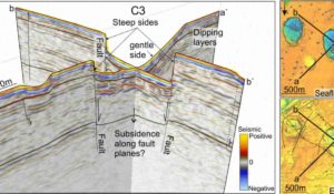
The researchers used seismic data to map underneath the seafloor of the Makassar Strait, a narrow seaway between the islands of Borneo and Sulawesi.

They found evidence of 19 ancient submarine landslides. Submarine landslides have triggered tsunami waves before, such as the 2018 event on Sulawesi in Indonesia, although most tsunamis are caused by large earthquakes.

Dr. Rachel Brackenridge, now at University of Aberdeen, said: “We found evidence of submarine landslides happening over 2.5million years.

“They happened every 160,000 years or so and ranged greatly in size.

“The largest of the landslides comprised 600 km3 of sediment, while the smallest we identified were five km3.

“There will be many smaller events that we have yet to identify.”

Dr. Brackenridge explained how they identified the ancient landslides.

“Seismic data allows us to image the subsurface. The different characteristics of rocks below the seabed allow us to reconstruct the conditions they were deposited in.

“We can see a layered and orderly seabed, then there are huge bodies of sediment that appear chaotic.

“We can tell from the internal characteristics that these sediments have spilled down a slope in a rapid, turbulent manner. It’s like an underwater avalanche.”

The researchers say that the strong ocean current that flows through the Makassar Strait could be behind the prehistoric events and any potential submarine landslides.

Dr. Uisdean Nicholson, who led the research at Heriot-Watt University, said: “The Makassar Strait is an important oceanic gateway. It’s through there the main branch of the Indonesian Throughflow transports water—over 10 million cubic metres a second—from the Pacific to the Indian Ocean.

“The current acts as a conveyor belt, transporting sediment from the Mahakam Delta and dumping it on the upper continental slope to the south, making the seabed steeper, weaker and more likely to collapse.

“We estimate the largest, tsunamigenic events—those that displace 100 km3—occurred every 500,000 years.

“Indonesia has mitigation and early warning measures in place in different parts of the country, but not the area that would be affected by a tsunami wave generated from these landslides.

“This includes the cities of Balikpapan and Samarinda, which have a combined population of over 1.6 million people.

“Such an event could be concentrated and amplified by Balikpapan Bay, the site selected for the new capital city of Indonesia.

“Our next step is to quantify the risk in this area by building various numerical models of landslide events and tsunami generation.

“This could help us predict a threshold size that causes dangerous tsunamis and help inform any mitigation strategies.

“We also plan to visit the coastal areas of Kalimantan to look for physical evidence for historic or prehistoric tsunamis, to test the model outcomes and further improve our understanding of this hazard.”

Professor David Tappin of the British Geological Survey and UCL was involved in the study, and is working on the Sulawesi tsunami, which struck the opposite side of the Makassar Strait in September 2018.

Professor Tappin said: “The new study on submarine landslides is important in demonstrating that the tsunami hazard in this region of Indonesia is possibly greater than previously thought, but more research is necessary to confirm this.”

Professor Ben Sapiie from Institut Teknologi Bandung, Indonesia, said: “This research enriches the Indonesian geological and geophysical communities’ knowledge about sedimentation and landslide hazards in the Makassar Strait. The future of earth sciences research is using an integrated, multi-scientific approach with international collaborators.”

Dr. Nicholson recently identified ancient submarine landslides near the Falkland Islands in a separate research project.

Reference:
Rachel E. Brackenridge et al. Indonesian Throughflow as a preconditioning mechanism for submarine landslides in the Makassar Strait, Geological Society, London, Special Publications (2020). DOI: 10.1144/SP500-2019-171

Note: The above post is reprinted from materials provided by Heriot-Watt University.

Excessive rain triggered 2018 Kīlauea volcano eruption, study finds

Lava streaming from an active vent during the 2018 eruption of Kīlauea Volcano
Lava streaming from an active vent during the 2018 eruption of Kīlauea Volcano. Credit: U.S. Geological Survey

Excessive and sustained rainfall triggered the 2018 eruption of Kīlauea volcano in Hawaii, according to researchers at the University of Miami (UM) Rosenstiel School of Marine and Atmospheric Science. The researchers suggest that local rainfall patterns may contribute significantly to the timing and frequency of the eruption at Kīlauea and perhaps at other volcanoes.

In a new study, published in the journal Nature, UM Rosenstiel School scientists Jamie Farquharson and Falk Amelung showed that the eruption was likely initiated by prolonged, and at times extreme, rainfall in the months leading up to the event.

“We knew that changes in the water content in the Earth’s subsurface can trigger earthquakes and landslides. Now we know that it can also trigger volcanic eruptions,” said Falk Amelung, professor of geophysics at the UM Rosenstiel School and coauthor of the study. “Under pressure from magma, wet rock breaks easier than dry rock. It is as simple as that.”

The long-lived eruption of Kīlauea, one of Hawaii’s most active volcanoes, entered an extraordinary new phase on May 3, 2018, throwing incandescent lava nearly two hundred feet in the air and spewing lava over 13 square miles across the well-populated east coast of Hawaii’s Big Island. The unprecedented eruption, which destroyed hundreds of homes, involved the collapse of the summit caldera before it ceased four months later in September 2018.

Using a combination of ground-based and satellite measurements of rainfall, Farquharson and Amelung modelled the fluid pressure within the volcano’s edifice over time—a factor that can directly influence the tendency for mechanical failure in the subsurface, ultimately driving volcanic activity.

The team’s results highlight that fluid pressure was at its highest in almost half a century immediately prior to the eruption, which they propose facilitated magma movement beneath the volcano. Their hypothesis also explains why there was no widespread uplift at the volcano in the months prior.

“An eruption happens when the pressure in the magma chamber is high enough to break the surrounding rock and the magma travels to the surface,” said Amelung. “This pressurization causes inflation of the ground by tens of centimeters. As we did not see any significant inflation in the year prior to the eruption we started to think about alternative explanations.”

While small steam explosions and volcanic earthquakes have been linked to rainfall infiltration at other volcanoes in the past, this is the first time that this mechanism has been invoked to explain deeper magmatic processes.

“Interestingly, when we investigate Kīlauea’s historical eruption record, we see that magmatic intrusions and recorded eruptions are almost twice as likely to occur during the wettest parts of the year,” said Jamie Farquharson, a postdoctoral researcher at the UM Rosenstiel School and lead author of the study.

The authors highlight that if this process can be detected at Kīlauea, then it is likely to occur elsewhere as well.

“Having established the evidence for rainfall-triggered eruptions at Kīlauea, it will be fascinating to investigate other volcanoes,” said Farquharson. “If we can identify regions of the globe where this kind of coupling between rainfall and volcanism exists, it could go a long way towards advanced warning of associated volcanic hazards.”

“It has been shown that the melting of ice caps in Iceland led to changes of volcanic productivity,” said Farquharson. “As ongoing climate change is predicted to bring about changes in rainfall patterns, we expect that this may similarly influence patterns of volcanic activity.”

“This study was only possible thanks to a number of Earth-observing satellites,” said Amelung. “We obtained precipitation information from a joint mission between NASA and the Japanese Space Exploration Agency and ground deformation observations from a mission of the European Space Agency.”

The study, titled “Extreme rainfall triggered the 2018 rift eruption at Kīlauea Volcano,” by Farquharson and Amelung from the UM Rosenstiel School of Marine and Atmospheric Science, was published April 22, 2020 in the journal Nature.

Reference:
Extreme rainfall triggered the 2018 rift eruption at Kīlauea Volcano, Nature (2020). DOI: 10.1038/s41586-020-2172-5

Note: The above post is reprinted from materials provided by University of Miami.

Researchers offer glimpse into dinosaur ecosystems

About 75 million years ago, southern Alberta was a lush and warm coastal floodplain rich in plant and animal life, similar to Louisiana’s environment today. Credit: Luke Dickey // Special to Western News

By casting an eye into the daily lives of dinosaurs millions of years in the past, Western researchers may be helping humanity get a glimpse of its future.

Seventy-five-million years ago, North America was divided into western and eastern landmasses by a shallow inland sea. The west was home to an extremely rich diversity of dinosaurs; it has been a mystery as to how so many big animals co-existed in such a small area.

Researchers have proposed that diversity was maintained by dividing up the landscape and food sources. For example, horned dinosaurs (ceratopsians) may have stuck to coastal areas, while duck-billed dinosaurs (hadrosaurs) preferred more inland habitats.

This idea remained untested, however, as researchers cannot directly observe dinosaur behavior and ecosystems.

To solve this conundrum, a team including Western researchers has now compared the compositions of stable isotopes in fossil teeth from these dinosaurs.

Stable isotopes are naturally occurring varieties of chemical elements (like carbon or oxygen) that do not change into other elements over time. When animals consume food and water, the stable isotopes of the elements that make up those resources are passed to the animal’s tissues, including tooth enamel.

The stable carbon and oxygen isotope compositions of these herbivorous dinosaurs were measured using various methods. The primary approach was laser gas chromatography isotope ratio mass spectrometry conducted at Western’s Laboratory for Stable Isotope Science (LSIS) by Anthropology professor Fred Longstaffe, Western research scientist Li Huang and project lead Thomas Cullen of the Field Museum.

“This approach allowed us to analyze very small samples and, because of that, extend the science of isotope ecology back into the time of the dinosaurs,” said Longstaffe, Canada Research Chair in Stable Isotope Science. “Normally, my isotope ecology work is focused on Ice Age animals and the reasons for their disappearance or survival. To attempt to reach back much deeper to the time when the dinosaurs lived was both challenging and exciting.”

The study, “Large-scale stable isotope characterization of a Late Cretaceous dinosaur-dominated ecosystem,” was recently published in the journal Geology.

The researchers compared results for numerous individuals of each dinosaur species to those of other animals in this ancient ecosystem. While multiple ecological patterns are evident in the results, and differences found in some species, the stable carbon and oxygen isotope ranges for large herbivorous dinosaurs were found to strongly overlap, providing direct evidence against the habitat use hypothesis.

“Measuring the ratios of the different isotopes of elements such as carbon or oxygen in tissues like tooth enamel gives us a unique window into the diet and habitat of an animal who has been extinct for millions of years,” Cullen said.

“Dinosaurs lived in a weird world: broad-leafed and flowering plants were much less common; it was warm enough in high latitudes to support crocodilians; carbon dioxide in the atmosphere was higher than it is today; and there was little to no ice at the poles.

“It’s not like anything we, as humans, have any direct experience with—but it may be the direction we are headed. It’s critical that we understand how ecosystems and environments function under those sorts of conditions so we can better prepare ourselves for the future.”

The new study is one of the largest ever conducted on a dinosaur ancient ecosystem, involving more than 350 isotopic measurements from 17 different species whose fossils had all accumulated in a single ancient wetland deposit. Even more uniquely, the authors combined this information with measurements from 16 living species that the team previously sampled from a modern coastal wetland in Louisiana.

About 75 million years ago, southern Alberta was a lush and warm coastal floodplain rich in plant and animal life, similar to Louisiana’s environment today.

Reference:
T.M. Cullen et al. Large-scale stable isotope characterization of a Late Cretaceous dinosaur-dominated ecosystem, Geology (2020). DOI: 10.1130/G47399.1

Note: The above post is reprinted from materials provided by University of Western Ontario.

New study takes the pulse of a sleeping supervolcano

This model shows how iron- and magnesium-rich magma (green) is formed at great depth and can move along the outer edges of the large Altiplano-Puna magma body (APMB)(red) to gradually force its way up to the surface during a volcanic eruption. Eruptions with such lava are uncommon and provide a unique insight into the processes that take place deep inside the Earth under the Andes. Credit: Osvaldo Gonzalez Maurel

Under the volcanoes in the Andes where Chile, Argentina and Bolivia meet, there is a gigantic reservoir of molten magma. For several million years, it has been there without fully solidifying or causing a supervolcanic eruption. Geologists have long wondered how this is possible. Researchers from Uppsala University, among others, have now discovered that the secret may be hidden tributaries of hot magma from inside the Earth.

The study is published in the journal Scientific Reports.

“Huge volcanic eruptions from so-called supervolcanoes are very unusual, but when they happen they are extremely devastating. It’s incredibly important for volcanologists to clarify what keeps this sleeping giant alive and what can cause it to awaken,” says Valentin Troll, Professor of Petrology at the Department of Earth Sciences at Uppsala University.

The giant so-called Altiplano-Puna magma body is estimated to contain 500,000 cubic kilometers of molten and semimolten magma. In order to provide a picture of how much volume is involved, it can be said that the entire island of Gran Canaria would fit inside — more than ten times over. The last really large volcanic eruption here occurred 4 million years ago and was the last in a series of very large explosive eruptions that began 10 million years ago. Some of them can be classified as supervolcanic eruptions.

In order to look for answers as to how the magma could stay molten for millions of years, the researchers studied lavas that were ejected from the magma reservoir during smaller volcanic eruptions after the last major eruption. The chemical composition of such material can provide an indication of how a magma reservoir works, how far down from inside the Earth the material originates, how long it remained in the reservoir and what different processes the magma underwent before it was ejected by the volcano.

In this case, the researchers wants to find out if new magma forces its way into the reservoir and therefore needed to find material that, after forming in the Earth’s mantle, was not affected by interaction with the magma that was already in the reservoir.

“This was a demanding task. Under these particular volcanoes in the Central Andes is the Earth’s thickest crust, 70 kilometers thick, which means that the magma is given many chances to change and react with the material it comes into contact with when it forces its way up to the surface,” says Frances Deegan, a researcher at Uppsala University.

The researchers therefore searched several years for lava that was as “original” as possible. Finally, they found what they were looking for. They have now analyzed the composition of the oxygen isotopes in their samples to find out how lavas were formed and where they originate from. The results showed that the lavas came from deep within the Earth and that they represent the material that feeds the volcanoes of the Central Andes, keeping them alive.

This new knowledge is important to understanding how large, complex volcanoes work.

“Supervolcanic eruptions can cause gigantic disasters. The last one that happened on the Earth was Toba’s super eruption in Indonesia 73,000 years ago and it is considered to have almost led to the extinction of mankind. Even if we can’t prevent a super eruption from happening, it would be smart to use the time until the next eruption to learn as much as possible to increase the chances for our communities to survive such an event,” says Valentin Troll.

Reference:
Osvaldo González-Maurel, Frances M. Deegan, Petrus le Roux, Chris Harris, Valentin R. Troll, Benigno Godoy. Constraining the sub-arc, parental magma composition for the giant Altiplano-Puna Volcanic Complex, northern Chile. Scientific Reports, 2020; 10 (1) DOI: 10.1038/s41598-020-63454-1

Note: The above post is reprinted from materials provided by Uppsala University.

New study finds connection between fault roughness and the magnitude of earthquakes

Fault
Credit: McGill University

A new study led by McGill University has found that tectonic plates beneath the Earth’s surface can show varying degrees of roughness and could help explain why certain earthquakes are stronger than others.

Earthquakes happen when the rocks beneath the Earth’s surface break along geological fault lines and slide past each other. The properties of these faults—such as the roughness of their surface—can have an influence on the size of seismic events, however their study has been challenging because they are buried deep beneath the Earth’s surface.

In order to have a better understanding of the characteristics of these faults, researchers from McGill University, the University of California Santa Cruz and Ruhr University Bochum in Germany used high-resolution seismic reflection data to map and measure the roughness of 350 km2 of a plate boundary fault located off the Pacific coast of Costa Rica.

“We already knew that the roughness of a fault was an important factor, but we did not know how rough faults in the subsurface truly are, nor how variable the roughness is for a single fault,” says James Kirkpatrick, a professor in McGill’s Department of Earth and Planetary Sciences.

Rougher surfaces of faults may explain earthquake magnitude

In a recently published study in Nature Geoscience, Kirkpatrick and his colleagues were able to show that some parts of the studied fault have a rougher surface than others.

Historically, the earthquakes that have occurred in this part of the world have been moderately large (M7) and Kirkpatrick, who is also the study’s first author, believes the rough patches they found might be the reason why.

“These rough patches are stronger and more resistant to earthquake slip,” he says. “The historical record of earthquakes is relatively short, so we can’t say with certainty that larger ones have not occurred. Future seismic events in the area, which will be recorded with modern equipment, should help us determine if they show the same limited magnitude.”

Kirkpatrick and his colleagues also hope to apply their methods to other subduction zones where similar geophysical data is available to start to evaluate whether their conclusions are generally applicable.

“This connection between the fault roughness and earthquake magnitude might one day help us understand the size and style of earthquakes most likely to occur a given fault.”

Reference:
James D. Kirkpatrick et al, Subduction megathrust heterogeneity characterized from 3D seismic data, Nature Geoscience (2020). DOI: 10.1038/s41561-020-0562-9

Note: The above post is reprinted from materials provided by McGill University.

Planet Earth. and You!

Planet Earth. and You!

Online Geology Courses : Earthquakes, volcanoes, mountain building, ice ages, landslides, floods, life evolution, plate motions—all of these phenomena have interacted over the vast expanses of deep time to sculpt the dynamic planet that we live on today. Planet Earth presents an overview of several aspects of our home, from a geological perspective. We begin with earthquakes—what they are, what causes them, what effects they have, and what we can do about them. We will emphasize that plate tectonics—the grand unifying theory of geology—explains how the map of our planet’s surface has changed radically over geologic time, and why present-day geologic activity—including a variety of devastating natural disasters such as earthquakes—occur where they do. We consider volcanoes, types of eruptions, and typical rocks found there. Finally, we will delve into the processes that produce the energy and mineral resources that modern society depends on, to help understand the context of the environment and sustainability challenges that we will face in the future.

Offered by: University of Illinois at Urbana-Champaign

The University of Illinois at Urbana-Champaign is a world leader in research, teaching and public engagement, distinguished by the breadth of its programs, broad academic excellence, and internationally renowned faculty and alumni. Illinois serves the world by creating knowledge, preparing students for lives of impact, and finding solutions to critical societal needs.

What you will learn from this course

Orientation

You will become familiar with the course, your classmates, and our learning environment. The orientation will also help you obtain the technical skills required for the course.

Week 1: Earthquakes!

In the lectures for this week, we will consider what an earthquake is, how it occurs, how we can record and measure its size, and what we can do to mitigate damage. Our first weekly assignment consists of reporting your own experience with earthquakes (if any). The Week 1 Lab gives you a chance to work with seismograms, locate an earthquake epicenter, and determine magnitude. Finally, the Week 1 Discussion addresses the balance between risks from quakes and costs of preventive measures.

Week 2: Plate Tectonics

In the early twentieth century, publication of the hypothesis on continental drift caused an uproar that soon died down. Data collected in mid-century led geologists to reconsider the idea that continents could move. During the 1960s and 1970s, old ideas were reworked into what is now called the theory of plate tectonics. As we will see, this robust theory encompasses many geological phenomena that appear to be unrelated at first glance: earthquakes and volcanoes, but also ice ages, fossils, and mountains. Today, plate tectonics provides an overarching framework for interpreting the Earth. We study its details in Week 2, but we will return to this theory again and again throughout the rest of this course.

Week 3: Volcanoes!

This week, you will learn how and where rocks can melt, and what happens when molten material of various compositions bursts out of the ground. The lecture videos also cover different types of eruptions, as well as the rocks and mountains produced by them. In the lab, you will study details about the 1980 eruption of Mount St. Helens and the eruption of Mount Vesuvius in the year 79. The discussion forum gives you the opportunity to weigh risks to people living on or near volcanoes and what can be done to minimize damage and loss of life. The weekly assignment provides a place for you to share your own experiences with volcanoes or eruptions or, if you have never been near a volcano, your thoughts about such events.

Week 4: Rocks and Mineral Resources

As part of the Week 4 Assignment, you will take a close look at your daily surroundings to identify Earth resources. The video lectures for the week examine various aspects of finding, extracting, and using resources such as metals and stones. For the lab, you will utilize Google Earth to examine several mining sites around the world. In the discussion, you will weigh the pros and cons of mining operations, as many communities have had to do already. This week also includes peer grading discussions, as explained on the How Graded Discussions Work page. Finally, we provide an optional assignment for those who would like to identify some common minerals.

Week 5: Energy Resources

The video lectures for this week cover various aspects of energy usage by modern civilization, especially our utilization of fossil fuels. The Week 5 Lab sends you on a Google Earth tour of energy-producing sites around the world, places where both conventional and alternative forms of energy are being generated. The Week 5 Assignment gives you a chance to survey your own personal use of energy – where does it come from and how much do you use – and then to share the information with others in the class. During the Week 5 Discussion, you will consider the implications of how society uses the energy of fossil fuels and the implications for the local environment and global climate.

Enroll Now


Related Articles