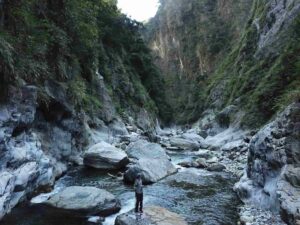
Drones flying along miles of rivers in the steep, mountainous terrain of central Taiwan and mapping the rock properties have revealed new clues about how water helps shape mountains over geological time, according to a team led by Penn State scientists.
The researchers found a link between the size of boulders in the rivers and the steepness of the rivers. The link shows how rock properties can influence the relationship between tectonic processes happening deep underground and how mountainous landscapes change shape. They reported in the journal Science Advances.
“Over the course of a mountain belt developing, we’re seeing differences in how rivers incise, or cut down into the bedrock, in the younger and older sections,” said Julia Carr, lead author of the study who earned her doctorate in geosciences from Penn State in 2022. “It means that as a mountain belt evolves, erosion is changing at the surface.”
As tectonic plates collide and form mountain ranges, rocks that were previously buried in the Earth’s crust are pushed to the surface in a process called uplift. The temperature and pressure that these rocks experience leads to variability in rock properties — like rock hardness or the spacing and orientation of fractures — that then affect how easily they are eroded by elements at the surface, the scientists said.
In Taiwan, the scientists found the main signature of rock strength of the mountains was the size of boulders in rivers, which were larger and stronger in locations where rocks had been buried deeper in Earth’s crust. And the size of boulders correlated with the steepness of the rivers, which must be powerful enough to move these boulders downstream before eroding the mountain, the scientists said.
“When the boulders in the channels are larger, the river needs to steepen to be able to erode at the same rate,” said Roman DiBiase, associate professor of geosciences at Penn State and co-author of the study. “This is because in order to erode rock, the sediment covering a river channel needs to move out of the way. The larger the boulders in the channel, the steeper the channel needs to be to move them.”
Models can account for how things like storms and floods impact erosion rates, but it’s harder to factor the role of rock strength on the process, the scientists said.
“Determining the controls on river incision into rock is important for understanding how mountain ranges evolve over geologic time,” DiBiase said. “But some key parameters for testing models of river incision, such as flow depth and sediment cover, are difficult to measure at large scales.”
The researchers turned to drones to avoid obstacles like hazardous river crossings and waterfalls to collect data. During these surveys, the scientists collected hundreds of thousands of measurements of river channel morphology and more than 22,000 measurements of boulders along roughly 18 miles of rivers.
“That’s where it’s really unprecedented — something of this scale is really unusual,” said Carr, who conducted the research at Penn State and is now a postdoctoral fellow at Simon Fraser University in British Columbia. “It’s exciting to be able to survey at this scale — it helps us see patterns we really would otherwise never see. If you just went into the field and surveyed the few spots you could get to easily, you would not observe this pattern.”
Taiwan’s central mountain range is one of the steepest landscapes on Earth and has one of the highest erosion rates of any place outside glaciated or human-influenced areas, Carr said. In addition, the tectonic setting of Taiwan is well known and has systematic burial depth patterns that can be used to evaluate the connection between subsurface history of rocks and their current condition at the surface.
“It’s this great unique place because unlike somewhere like the Himalayas or the Alps, where there’s so many complex tectonic histories, Taiwan can be a relatively simple landscape to study because the same collision forces that created it millions of years ago are still active today,” Carr said. “And these lessons learned from Taiwan can help inform erosion models that are applied to other mountain ranges with fewer constraints.”
Because of how the range formed, younger rocks are found in the south and west, while older rocks that were buried deeper — up to 24 miles underground — are found further east and north, the scientists said.
In the younger sections, rivers have fewer, smaller boulders that cover less of the area of the channels. And as you travel toward the older sections, the boulders increase to a median size of more than six feet, the scientists said.
These boulders aren’t sitting in the rivers waiting to be broken down over time, according to the researchers. Instead, boulders in each of the sections of rivers were close to the threshold of mobility — meaning the water was nearly powerful enough to move them downstream. During high flows after storms, these boulders may be fully mobile, and as they move, they help incise the river.
“One way you can think about how rivers incise long term — you need to be able to move sediment, and once you cross over some threshold, you can incise the river,” Carr said. “If we apply this, it implies this primary rock strength signal controlling boulder size is setting river incision in the landscape. And that matches with the local steepness of the rivers.”
Also contributing were Donald Fisher, professor of geosciences at Penn State; En-Chao Yeh, associate professor at National Taiwan Normal University; and Eric Kirby, professor at University of North Carolina at Chapel Hill.
The National Science Foundation supported this work.
Link to drone video footage: https://youtu.be/uER7H-zm1yE
Reference:
Julia C. Carr, Roman A. DiBiase, En-Chao Yeh, Donald M. Fisher, Eric Kirby. Rock properties and sediment caliber govern bedrock river morphology across the Taiwan Central Range. Science Advances, 2023; 9 (46) DOI: 10.1126/sciadv.adg6794
Note: The above post is reprinted from materials provided by Penn State. Original written by Matthew Carroll.


