A scientific team has discovered the geological footprint of earthquakes and tsunamis that affected the Aysén region (southern Chile) up to 9,000 years ago. This new study improves the assessment of seismic hazard in a wide area of the American continent prone to large earthquakes.
The study, published in Journal of Geophysical Research: Solid Earth, enabled the researchers to establish the first paleoseismological record of the Liquiñe-Ofqui Fault Zone (LOFZ), a large geological structure that crosses southern Chile and is partially responsible for the seismic activity of the Andean country.
The LOFZ fracture area, which stretches over more than 1,000 kilometres north-south in Chile, is a geological structure associated with volcanism and that has an impact on the relief of the Andean country. This seismically hazardous area has some active volcanoes –such as Macá, Hudson and Mentolat- and steep reliefs that can enlarge the effects of the most violent geological phenomena.
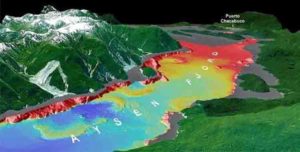
In this area, Aysén fjord is a model to study geological processes –earthquakes, tsunamis, etc.— that can be a threat to the local population. According to Galderic Lastras, “the Aysén fjord is cross-cut by the strike-slip fault system (LOFZ) that causes local earthquakes, such as the crisis in 2007. The main earthquake of this crisis —magnitude 6.2— caused dozens of landslides and a local tsunami, with some casualties and important damage to fish farms.”
“Moreover, this fjord is quite close to the plate boundary between the South American and the Nazca Plates, an active subduction zone that causes large magnitude earthquakes,” says Lastras, expert on submarine cartography and head of the oceanographic survey DETSUFA that worked on the cartography of the geological footprint of submarine landslides in Aysén.
Aysén fjord: earthquakes and tsunamis in a natural laboratory
When an earthquake occurs –moderate or strong-, it can destabilize the mountain slopes that surround the fjord. Rock masses can slide and fall until reaching the fjord bottom, causing local tsunamis. This forms an increased risk for the population since there is an extremely short warning time. The geological footprint of these landslides ─piled up at the bottom of the fjord and separated by sediments─ is then visible in the sedimentary record.
According to Maarten Van Daele, postdoctoral researcher and expert on sedimentary deposits created by earthquakes, “strong seismic shaking triggers both onshore and subaquatic landslides. These are buried in the fjord and we can image and map them using geophysical methods. In this study, we also retrieved sediment cores, which allowed us to determine ages for the landslide events using radiocarbon dating of organic material in the sediment.”
Combining different geophysical techniques —reflection seismics, geochemistry of volcanic ashes, etc.— the scientific team constructed the first paleoseismic record of the Liquiñe-Ofqui Fault Zone. “For the first time —adds Van Daele— we have a rough idea of earthquake recurrence rates along this fault. Other similar studies are needed along the fault trace, but this is an important first step to improve the assessment of the seismic hazard in the region.”
Looking for the most violent seismic episodes
Earthquakes can destabilize fjord slopes and cause landslides, but other factors such as heavy rainfall can also be involved and enhance slope instability. As a result, the experts could identify evidence of ten earthquakes in Aysén fjord –including the most recent one in 2007— but the amount of such earthquake events is probably even higher since not every earthquake will cause a significant landslide.
According to Katleen Wils, predoctoral researcher at Ghent University and first author of the study, “we know these landslides occurred due to a common trigger: an earthquake. In the Aysén region, the main source of seismic hazard comes from the LOFZ fault rather than the subduction zone. Those earthquakes had intensities similar to those occurring during the 2007 main episode, which was up to IX, corresponding to violent shaking and considerable damage.”
“According to the data, six of the analysed earthquake events took place in the fjord during the last 9,000 years, while the other four occurred before that. This shows that there is an important seismic hazard in the region, mainly originating from the LOFZ, but also from the subduction zone,” notes Wils, expert on geophysics and the study of earthquakes and seismic hazard.
The number of earthquakes recorded in Aysén fjord may be clear, but “it is more difficult to have a clear idea of their magnitude,” warns Galderic Lastras. “One of the identified events has a similar age (about 2,000 years before present) to a tsunami deposit described in the coastal Lake Huelde, in Chiloé Island, and with a turbidite in Lake Riñihue. Identifying signs of an earthquake in different locations far away from each other is a sign of a large magnitude earthquake, which has likely originated in the subduction zone.”
According to the authors, their study reveals that LOFZ is an active fault system that should be characterized in more detail in future studies in order to have more knowledge on the complete seismic system.
Paleoseismology: the unwritten history of great earthquakes
The paleoseismological record of Aysén fjord is an important part of the geological history of the region as a written record of past earthquakes in the area is non-existent. Understanding the rate at which earthquakes took place in the past is essential to infer the occurrence of future earthquakes.
Because of this uncertainty, “geological research is an essential tool to explain the unwritten history of the most violent earthquake events that affected a certain area. It is important to know as much as possible about past seismic activity of a region. This means that technology and scientific knowledge are the key to improve the assessment of seismic hazard, mitigate the effects of natural disasters and help society directly,” the authors write.
Reference:
Katleen Wils et al. Holocene Event Record of Aysén Fjord (Chilean Patagonia): An Interplay of Volcanic Eruptions and Crustal and Megathrust Earthquakes, Journal of Geophysical Research: Solid Earth (2017). DOI: 10.1002/2017JB014573
Note: The above post is reprinted from materials provided by University of Barcelona.


 up to 9,000 years ago. This new study improves the assessment of seismic hazard in a wide area of the American continent prone to large earthquakes.)