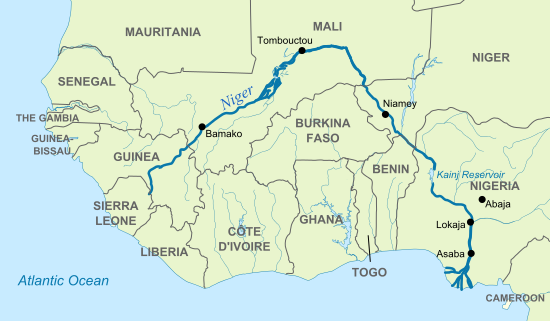
The Niger River is the principal river of western Africa, extending about 4,180 km (2,600 mi). Its drainage basin is 2,117,700 km2 (817,600 sq mi) in area. Its source is in the Guinea Highlands in southeastern Guinea. It runs in a crescent through Mali, Niger, on the border with Benin and then through Nigeria, discharging through a massive delta, known as the Niger Delta or the Oil Rivers, into the Gulf of Guinea in the Atlantic Ocean. The Niger is the third-longest river in Africa, exceeded only by the Nile and the Congo River (also known as the Zaïre River). Its main tributary is the Benue River.
Etymology
The Niger is called Jeliba or Joliba “great river” in Manding; Orimiri or Orimili “great water” in Igbo; Egerew n-Igerewen “river of rivers” in Tuareg; Isa Ber “big river” in Songhay; Kwara in Hausa; and Oya in Yoruba. The origin of the name Niger, which originally applied only to the middle reaches of the river, is uncertain. The likeliest possibility is an alteration, by influence of Latin niger “black”, of the Tuareg name egerew n-igerewen, which is used along the middle reaches of the river around Timbuktu. As Timbuktu was the southern end of the principal Trans-Saharan trade route to the western Mediterranean, it was the source of most European knowledge of the region.
Medieval European maps applied the name Niger to the middle reaches of the river, in modern Mali, but Quorra (Kworra) to the lower reaches in modern Nigeria, as these were not recognized as being the same river. When European colonial powers began to send ships along the West coast of Africa in the 16th and 17th centuries, the Senegal River was often postulated to be seaward end of the Niger. The Niger Delta, pouring into the Atlantic through mangrove swamps and thousands of distributaries along more than a hundred miles, was thought to be no more than coastal wetlands. It was only with the 18th century visits of Mungo Park, who travelled down the Niger River and visited the great Sahelian empires of his day, that Europeans correctly identified the course of the Niger, and extending the name to its entire course.
The modern nations of Nigeria and Niger take their names from the river, marking contesting national claims by colonial powers of the “Upper”, “Lower” and “Middle” Niger river basin during the Scramble for Africa at the end of the 19th century.
Geography
The Niger River is a relatively “clear” river, carrying only a tenth as much sediment as the Nile because the Niger’s headwaters lie in ancient rocks that provide little silt. Like the Nile, the Niger floods yearly; this begins in September, peaks in November, and finishes by May.
An unusual feature of the river is the Inner Niger Delta, which forms where its gradient suddenly decreases. The result is a region of braided streams, marshes, and lakes the size of Belgium; the seasonal floods make the Delta extremely productive for both fishing and agriculture.
The river ‘loses’ nearly two-thirds of its potential flow in the Inner Delta between Ségou and Timbuktu to seepage and evaporation. All the water from the Bani River, which flows into the Delta at Mopti, does not compensate for the ‘losses’. The average ‘loss’ is estimated at 31 km3/year, but varies considerably between years. The river is then joined by various tributaries, but also loses more water to evaporation. The quantity of water entering Nigeria measured in Yola was estimated at 25 km3/year before the 1980s and at 13.5 km3/year during the 1980s. The most important tributary of the Niger in Nigeria is the Benue River which merges with the river at Lokoja in Nigeria. The total volume of tributaries in Nigeria is six times higher than the inflow into Nigeria, with a flow near the mouth of the river standing at 177.0 km3/year before the 1980s and 147.3 km3/year during the 1980s.
The above story is based on materials provided by Wikipedia


. Its drainage basin is 2,117,700 km2 (817,600 sq mi)