The Lena is the easternmost of the three great Siberian rivers that flow into the Arctic Ocean (the other two being the Ob River and the Yenisei River). It is the 11th longest river in the world and has the 9th largest watershed. It is the largest among the rivers whose watershed is entirely within the Russian territorial boundaries.
Course
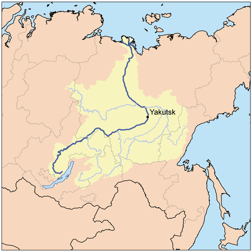
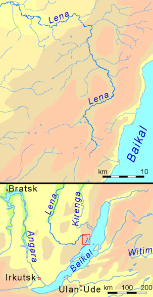
Rising at a height of 1,640 metres (5,381 ft) at its source in the Baikal Mountains south of the Central Siberian Plateau, 7 kilometres (4 mi) west of Lake Baikal, the Lena flows northeast, being joined by the Kirenga River, Vitim River and Olyokma River. From Yakutsk it enters the lowlands and flows north until joined by its right-hand tributary the Aldan River. The Verkhoyansk Range deflects it to the north-west; then after receiving its most important left-hand tributary, the Vilyuy River, it makes its way nearly due north to the Laptev Sea, a division of the Arctic Ocean, emptying south-west of the New Siberian Islands by the Lena Delta – 30,000 square kilometres (11,583 sq mi) in area, and traversed by seven principal branches, the most important being the Bykov, farthest east.
Basin
The total length of the river is estimated at 4,400 km (2,700 mi). The area of the Lena river basin is calculated at 2,490,000 square kilometres (961,394 sq mi). Gold is washed out of the sands of the Vitim and the Olyokma, and mammoth tusks have been dug out of the delta.
Tributaries
The Kirenga River flows north between the upper Lena and Lake Baikal. The Vitim River drains the area northeast of Lake Baikal. The Olyokma River flows north. The Amga River makes a long curve southeast and parallel to the Lena and flows into the Aldan. The Aldan River makes similar curve southeast of the Aldan and flows into the Lena north of Yakutsk. The Maya River, a tributary of the Aldan, drains an area almost to the Sea of Okhotsk. The T-shaped Chona-Vilyuy River system drains most of the area to the west.
History
It is commonly believed that the river Lena derives its name from the original Even-Evenk name Elyu-Ene, which means “the Large River”.
According to folktales related a century after the fact, in the years 1620–23 a party of Russian fur hunters under the leadership of Demid Pyanda sailed up Lower Tunguska, and discovered the proximity of Lena and either carried their boats there or built new ones. In 1623 Pyanda explored some 2,400 kilometers of the river from its upper rocky part to its wide flow in the central Yakutia. In 1628 Vasily Bugor and ten men reached the Lena, collected yasak from the natives and founded Kirinsk in 1632. In 1631 the voyevoda of Yeniseisk sent Pyotr Beketov and twenty men to found an ostrog at Yakutsk (founded in 1632). From Yakutsk other expeditions spread out to the south and east. The Lena delta was reached in 1633.
Baron Eduard Von Toll, accompanied by Alexander von Bunge, carried out an expedition to the Lena delta area and the islands of New Siberia on behalf of the Russian Imperial Academy of Sciences in 1885. They explored the Lena delta with its multitude of arms that flow towards the Arctic Ocean. Then in spring 1886 they investigated the New Siberian Islands and the Yana River and its tributaries. During one year and two days the expedition covered 25,000 km, of which 4,200 km were up rivers, carrying out geodesic surveys en route.
Vladimir Ilyich Ulyanov may have taken his alias, Lenin, from the river Lena, when he was exiled to the Central Siberian Plateau, but the origin of his pen name is uncertain.
Lena delta
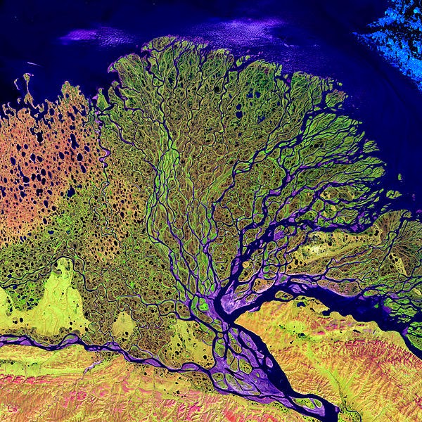
At the end of the Lena River there is a large delta that extends 100 kilometres (62 mi) into the Laptev Sea and is about 400 km (250 mi) wide. The delta is frozen tundra for about 7 months of the year, but in May transforms the region into a lush wetland for the next few months. Part of the area is protected as the Lena Delta Wildlife Reserve.
The Lena delta divides into a multitude of flat islands. The most important are (from west to east): Chychas Aryta, Petrushka, Sagastyr, Samakh Ary Diyete, Turkan Bel’keydere, Sasyllakh Ary, Kolkhoztakh Bel’keydere, Grigoriy Diyelyakh Bel’kee (Grigoriy Islands), Nerpa Uolun Aryta, Misha Bel’keydere, Atakhtay Bel’kedere, Arangastakh, Urdiuk Pastakh Bel’key, Agys Past’ Aryta, Dallalakh Island, Otto Ary, Ullakhan Ary and Orto Ues Aryta.
Turukannakh-Kumaga is a long and narrow island off the Lena delta’s western shore.
One of the Lena delta islands, Ostrov Amerika-Kuba-Aryta or Ostrov Kuba-Aryta, was named after the island of Cuba during Soviet times. It is on the northern edge of the delta.
Note : The above story is based on materials provided by Wikipedia


