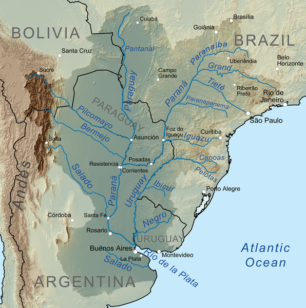
The Paraná River is a river in south Central South America, running through Brazil, Paraguay and Argentina for some 4,880 kilometres (3,030 mi). It is second in length only to the Amazon River among South American rivers. The name Paraná is an abbreviation of the phrase “para rehe onáva”, which comes from the Tupi language and means “like the sea” (that is, “as big as the sea”). It merges first with the Paraguay River and then farther downstream with the Uruguay River to form the Río de la Plata and empties into the Atlantic Ocean.
Course
The course is formed at the confluence of the Paranaiba and Grande rivers in southern Brazil. From the confluence the river flows in a generally southwestern direction for about 619 km (385 mi) before encountering the city of Saltos del Guaira, Paraguay. This was once the location of the Sete Quedas waterfall, where the Paraná fell over a series of seven cascades. This natural feature was said to rival the world famous Iguazu Falls to the south. The falls were flooded, however, by the construction of the Itaipu dam, which began operating in 1984.
For approximately the next 200 km (120 mi) the Paraná flows southward and forms a natural boundary between Paraguay and Brazil until the confluence with the Iguazu River. Shortly upstream from this confluence, however, the river is dammed by the Itaipu Dam, the second largest hydroelectric power station in the world (after the Three Gorges Dam in the People’s Republic of China), and creating a massive, shallow reservoir behind it.
After merging with the Iguazu, the Paraná then becomes the natural border between Paraguay and Argentina. Overlooking the Paraná River from Encarnación, Paraguay, across the river, is downtown Posadas, Argentina. The river continues its general southward course for about 468 km (291 mi) before making a gradual turn to the west for another 820 km (510 mi), and then encounters the Paraguay River, the largest tributary along the course of the river. Before this confluence the river passes through a second major hydroelectric project, the Yaciretá dam, a joint project between Paraguay and Argentina. The massive reservoir formed by the project has been the source of a number of problems for people living along the river, most notably the poorer merchants and residents in the low lying areas of Encarnación, a major city on the southern border of Paraguay. River levels rose dramatically upon completion of the dam, flooding out large sections of the city’s lower areas.
From the confluence with the Paraguay River, the Paraná again turns to the south for another approximately 820 km (510 mi) through Argentina, making a slow turn back to the east near the city of Rosario for the final stretch of less than 500 km (310 mi) before merging with the Uruguay River to form the Río de la Plata and emptying into the Atlantic Ocean. During the part of its course downstream from the city of Diamante, Entre Ríos, it splits into several arms and forms the Paraná Delta, a long flood plain which reaches up to 60 km in width.
Note : The above story is based on materials provided by Wikipedia


. It)