Researchers from the University of Helsinki and the University of Tübingen have come up with a new way of analysing sand in mountain rivers to determine the activity of landslides upstream, which has important implications for understanding natural hazards in mountainous regions.
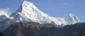
Landslides occur in hilly and mountainous landscapes, often triggered by extreme rainfall events or ground shaking resulting from earthquakes. For example, a magnitude 7.8 earthquake in Nepal in April 2015 and its aftershocks are estimated to have triggered more than 25,000 landslides. For people living in these regions landslides are a major natural hazard, thus knowledge of the history of landslide activity in these areas is critical to understanding and mitigating their risk.
Measuring the pace of landslide erosion with a handful of sand
The 2015 Nepal earthquake and the landslides it triggered were dramatic examples of natural hazards associated with a single event, but knowledge of the longer-term behaviour of landslide activity in a region is much more difficult to measure. The authors developed a new technique that enables them to understand how often landslides occur in a region and how long the sediment produced from landslides remains within a river system before being transported downstream.
“Our approach is based quite simply on taking a handful of sand from a river and measuring the chemistry of the sediments” says Todd Ehlers, co-author of the study and professor in the Department of Geociences at the University of Tübingen, Germany. “When combined with computer models we can determine how much landslide activity exists upstream of the location where the sediment was collected, and how long landslide produced sediment was in the river before being flushed out.”
Previous studies have been limited in their ability to determine how often landslides occur and how significant these events are at eroding topography compared to other processes such as river or glacier erosion. “What is surprising in this study is that we figured out a way to address both limitations that previous studies have struggled with”, Ehlers explains.
The results of the study have implications for understanding how active and important landslides are in a region, and also how long these catastrophic events swamp the rivers with sediment.
Heavy monsoon rainfall wipes the landscape clean
“Sediment in these steep landscapes is transported downstream surprisingly quickly” says David Whipp, study lead author and associate professor in the Institute of Seismology at the University of Helsinki. He continues “while sediment in many river systems may be stored for tens of thousands of years, our results suggest most of the sediment in the steep Himalayan mountains remains in the river system for no more than ten years.”
This surprising finding speaks to the immense power of water flowing in Himalayan mountain rivers during the annual monsoon season, which helps transport massive volumes of sediment downstream.
Reference:
“Quantifying landslide frequency and sediment residence time in the Nepal Himalaya” Science Advances (2019). DOI: 10.1126/sciadv.aav3482
Note: The above post is reprinted from materials provided by University of Helsinki.


