Under Mexico, where the Cocos Plate from the Pacific Ocean slides under the North American Plate, a bending line of hills, created when the seafloor first formed, sits atop a flattened area of subduction.
That newly recognized combination, scientists report, has created a fault that likely explains last September’s Puebla earthquake, scientists report.
On Sept. 19, a 7.1 magnitude quake struck 55 kilometers (34 miles) south of Puebla and 100 kilometers (62 miles) from Mexico City. It caused damage from the capital southeast through the states of Puebla and Morelos. In Mexico City alone, there were 228 deaths and more than 40 buildings collapsed.
“The 2017 earthquake was peculiar but not all that uncommon,” said University of Oregon seismologist Diego Melgar, lead author of a newly published paper. “The question became could earthquakes like this one occur closer to Mexico City? The answer is uncertain but it seems like it is unlikely.”
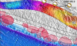
In a geometry-heavy analysis published online ahead of print in the journal Geophysical Research Letters, a seven-member research team of U.S. and Mexican scientists mapped a zone of high earthquake risks in a line going southeast of Mexico City that includes Puebla City, Oaxaca and Tehuacan.
Mexico City is in a hazy area, Melgar said. The map has a spot directly south where a quake conceivably could occur. Similar earthquakes in 1980 and 1999 in less populated areas to the southeast also occurred within the map. The research is part on an on-going effort to better understand Mexico’s earthquake risks.
“This 2017 earthquake was a test for the national capabilities on rapidly reporting an event in a region with a relatively good station coverage, said study co-author Xyoli Pérez-Campos, chief of Mexico’s National Seismological Service. “It also posed new scientific and social questions, of particular significance was how plausible it is to have a similar event closer to Mexico City.”
Inland earthquakes are known to happen, Melgar said, but there has been insufficient information for hazard maps that guide building codes and readiness plans.
“We find that earthquakes like the Puebla earthquake in 2017 are not always prioritized in Mexico when we think about the earthquakes that can happen,” Melgar said. “We need to prepare for these kinds of earthquakes, as well, not just for the earthquakes like 1985 that strike far away along the coast.”
The research focused on the fabric of the seafloor, particularly slightly raised fault lines called abyssal hills. They appear like lines of waves occurring repeatedly outward as mid-ocean ridges spread apart in pulses. The lines can read much like tree rings.
“They record the rates at which the seafloor is being formed,” Melgar said. “By looking at them we can tell if seafloor is being made quickly or slowly.”
Earthquakes in Mexico normally are generated offshore where the two plates converge like those in the Cascadia Subduction Zone from northern California to British Columbia, Canada.
The 8.1 magnitude Mexico City earthquake on Sept. 19, 1985, was a typical one. Centered in the ocean 250 miles west, it killed 10,000 people and destroyed 3,000 buildings. The capital’s susceptibility to earthquake damage is the result of the soft soil of an ancient lake on which the city was built.
“The smaller, inland 2017 earthquake comes along, but it was much closer to the city,” Melgar said. “It also impacted the city because of the lake bed that allows shaking to occur for longer periods than an earthquake on solid bedrock. We wanted to know why the 2017 earthquake happened at that particular location.”
The team showed that the lines of abyssal hills initially occurred at regularly occurring intervals as the Cocos Plate descended under the Mexico. However, that alignment eventually changed dramatically as the depth of areas of subduction shifted under the nation’s surface.
Where the subduction continued at deep angles, hills atop the diving plate shifted to a northeasterly direction. Beginning just south of Mexico City, the alignment of hills shifted, reflecting a zone where plate subduction flattened.
The 2017 earthquake likely was the result of “bending stresses occurring at the transition from flat-slab subduction to steeply dipping subduction,” the researchers concluded. “It’s like the grain on a plank of wood,” Melgar said. “If you bend with the grain or across the grain you might get some resistance. When you go too far, you get a snap.”
Where subduction stays deep, offshore earthquakes will continue to pose the most risk. The shallower subduction zone is at risk for land-based earthquakes.
An 8.2 earthquake near Chiapas that occurred two weeks before Sept. 19 Puebla event also may be related to the misalignment pattern, Melgar said.
Similar flat-slab subduction zones where such misalignment occurs, he said, may be common southward through Guatemala, El Salvador and Nicaragua, and again in Peru and northern Chile.
Reference:
Diego Melgar, Xyoli Pérez-Campos, Leonardo Ramirez-Guzman, Zack Spica, Victor Hugo Espíndola, William C. Hammond, Enrique Cabral-Cano. Bend Faulting at the Edge of a Flat Slab: The 2017 M w7.1 Puebla-Morelos, Mexico Earthquake. Geophysical Research Letters, 2018; DOI: 10.1002/2017GL076895
Note: The above post is reprinted from materials provided by University of Oregon.


