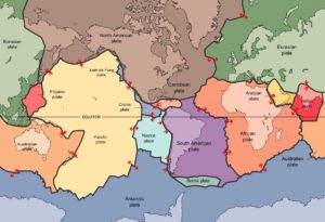
Plate tectonics is a scientific theory describing the large-scale motion of seven large plates and the movements of a larger number of smaller plates of the Earth’s lithosphere, since tectonic processes began on Earth between 3 and 3.5 billion years ago. The model builds on the concept of continental drift, an idea developed during the first decades of the 20th century. The geoscientific community accepted plate-tectonic theory after seafloor spreading was validated in the late 1950s and early 1960s.
The lithosphere, which is the rigid outermost shell of a planet (the crust and upper mantle), is broken into tectonic plates. The Earth’s lithosphere is composed of seven or eight major plates (depending on how they are defined) and many minor plates. Where the plates meet, their relative motion determines the type of boundary: convergent, divergent, or transform. Earthquakes, volcanic activity, mountain-building, and oceanic trench formation occur along these plate boundaries (or faults). The relative movement of the plates typically ranges from zero to 100 mm annually.
How do these massive slabs of solid rock float despite their tremendous weight?
The answer lies in the composition of the rocks. Continental crust is composed of granitic rocks which are made up of relatively lightweight minerals such as quartz and feldspar. By contrast, oceanic crust is composed of basaltic rocks, which are much denser and heavier. The variations in plate thickness are nature’s way of partly compensating for the imbalance in the weight and density of the two types of crust. Because continental rocks are much lighter, the crust under the continents is much thicker (as much as 100 km) whereas the crust under the oceans is generally only about 5 km thick. Like icebergs, only the tips of which are visible above water, continents have deep “roots” to support their elevations.
How did oceanic plate boundaries mapped?
Most of the boundaries between individual plates cannot be seen, because they are hidden beneath the oceans. Yet oceanic plate boundaries can be mapped accurately from outer space by measurements from GEOSAT satellites. Earthquake and volcanic activity is concentrated near these boundaries. Tectonic plates probably developed very early in the Earth’s 4.6-billion-year history, and they have been drifting about on the surface ever since-like slow-moving bumper cars repeatedly clustering together and then separating.
Types of plate boundaries
Transform boundaries
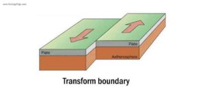
Transform boundaries (Conservative) occur where two lithospheric plates slide, or perhaps more accurately, grind past each other along transform faults, where plates are neither created nor destroyed. The relative motion of the two plates is either sinistral (left side toward the observer) or dextral (right side toward the observer). Transform faults occur across a spreading center. Strong earthquakes can occur along a fault. The San Andreas Fault in California is an example of a transform boundary exhibiting dextral motion.
Divergent boundaries
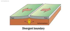
Divergent boundaries (Constructive) occur where two plates slide apart from each other. At zones of ocean-to-ocean rifting, divergent boundaries form by seafloor spreading, allowing for the formation of new ocean basin. As the ocean plate splits, the ridge forms at the spreading center, the ocean basin expands, and finally, the plate area increases causing many small volcanoes and/or shallow earthquakes. At zones of continent-to-continent rifting, divergent boundaries may cause new ocean basin to form as the continent splits, spreads, the central rift collapses, and ocean fills the basin. Active zones of Mid-ocean ridges (e.g., Mid-Atlantic Ridge and East Pacific Rise), and continent-to-continent rifting (such as Africa’s East African Rift and Valley, Red Sea) are examples of divergent boundaries.
Convergent boundaries
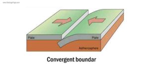
Convergent boundary, also known as a destructive plate boundary, is a region of active deformation where two or more tectonic plates or fragments of the lithosphere near the end of their life cycle. This is in contrast to a constructive plate boundary (also known as a mid-ocean ridge or spreading center). As a result of pressure, friction, and plate material melting in the mantle, earthquakes and volcanoes are common near destructive boundaries, where subduction zones or an area of continental collision (depending on the nature of the plates involved) occurs. The subducting plate in a subduction zone is normally oceanic crust, and moves beneath the other plate, which can be made of either oceanic or continental crust. During collisions between two continental plates, large mountain ranges, such as the Himalayas are formed. In other regions, a divergent boundary or transform faults may be present.
Reference:
Wikipedia: Plate tectonics
USGS: What is a tectonic plate?
Wikipedia: Transform fault
Wikipedia: Divergent boundary
Wikipedia: Convergent boundary


